county of los angeles enterprise geographic...
TRANSCRIPT

County of Los Angeles
Enterprise Geographic Information Systems (eGIS) Services Catalog Chief Information Office/Internal Services Department July 2015

Revision History
Version Date Name Description
Version 1.0 06/30/2015 Mark Greninger and Christine Lam First Draft

eGIS Services Catalog
i | P a g e
Contents Executive Summary ...................................................................................................................................... iv
eGIS Data Services ......................................................................................................................................... A
eGIS Online Mapping Services ...................................................................................................................... B
eGIS Countywide Applications ...................................................................................................................... C
eGIS License Management Services .............................................................................................................. D
eGIS Training and Support Services .............................................................................................................. E
GIS Solutions ................................................................................................................................................. F
eGIS Data Services ......................................................................................................................................... 1
Attachment List ........................................................................................................................... 1
Enterprise GIS Data Repository ................................................................................................... 1
GIS Data Acquisition .................................................................................................................... 5
eGIS Online Mapping Services .................................................................................................................... 12
Attachment List ......................................................................................................................... 12
Web Services ............................................................................................................................. 12
Map services .............................................................................................................................. 13
Geocode services ...................................................................................................................... 15
Query and Identification Services ............................................................................................. 16
Routing Services ........................................................................................................................ 16
Security ...................................................................................................................................... 16
Optimized Search Services (Geocortex Instant Search) ............................................................ 16
Custom GIS web services .......................................................................................................... 17
GIS Web API and GIS Application Development ....................................................................... 18
Service Level .............................................................................................................................. 19
eGIS Countywide Applications .................................................................................................................... 20
Attachment List ......................................................................................................................... 20
Service Locator .......................................................................................................................... 20
District Locator .......................................................................................................................... 21
GIS Viewer ................................................................................................................................. 22
Parcel viewer ............................................................................................................................. 23
Latitude Geographics Geocortex Application Development Framework ................................. 24
Application Hosting and Monitoring ......................................................................................... 25
Monitoring ................................................................................................................................. 25

eGIS Services Catalog
ii | P a g e
Mobile ....................................................................................................................................... 25
Service Level .............................................................................................................................. 26
eGIS License Management Services ............................................................................................................ 27
Attachment List ......................................................................................................................... 27
Esri Software ............................................................................................................................. 27
Google Maps API ....................................................................................................................... 28
Microsoft Bing ........................................................................................................................... 28
Service Level .............................................................................................................................. 29
eGIS Training and Support Services ............................................................................................................ 30
Attachment List ......................................................................................................................... 30
GIS Training ............................................................................................................................... 30
Customer Support ..................................................................................................................... 30
Service Level .............................................................................................................................. 30
GIS Solutions ............................................................................................................................................... 32
Attachment List ......................................................................................................................... 32
Custom maps ............................................................................................................................. 32
Custom scripts and tools ........................................................................................................... 32
Analysis and Research ............................................................................................................... 32
Application development .......................................................................................................... 33
Service Level .............................................................................................................................. 33
Attachments ................................................................................................................................................ 34
Attachment 1 - Enterprise GIS Strategic Plan - Update April 2015 ........................................... 35
Attachment 2 - GIS Case Studies ............................................................................................... 36
Attachment 3 – eGIS Service Level Agreement ........................................................................ 37
Attachment A.1 - TD 12-02 EGIS Central Repository ................................................................ 38
Attachment A.2 - Sample Geospatial Data Maintenance Agreement ...................................... 39
Attachment A.3 - LA County Enterprise GIS Data Catalog.xlsx ................................................. 40
Attachment A.4 - eGIS Database Server Access Instructions .................................................... 41
Attachment A.5 - eGISDataMaintProcess_v2_20150501 - MG comments .............................. 42
Attachment A.6 - Countywide Address Management System (CAMS) Editor's Guide ............. 43
Attachment B.1 - Instructions for publishing departmental map services ............................... 44
Attachment B.2 - Web Services Guide ...................................................................................... 45
Attachment B.3 - CIO Preferred Technologies for GIS .............................................................. 46

eGIS Services Catalog
iii | P a g e
Attachment C.1 - TD 12-04 EGIS Central Infrastructure ........................................................... 47
Attachment C.2 - Services Locator - LMS Governance.............................................................. 48
Attachment C.3 - Accessing Your Geocortex Viewer ................................................................ 49
Attachment D.1 - TD 12-03 EGIS Centralized Software Management ...................................... 50
Attachment D.2 - ESRI Master Purchase Agreement ................................................................ 51
Attachment D.3 - ESRI Software MPA attachment purchase rider........................................... 52
Attachment E.1 - LA County GIS Viewer Manual ...................................................................... 53
Attachment E.2 - LA County Parcel Viewer Manual .................................................................. 54

eGIS Services Catalog
iv | P a g e
Executive Summary Geographic Information Systems (GIS) technologies are powerful tools for improving the quality,
accuracy, efficiency, and responsiveness of government services provided by the County of Los Angeles.
An Enterprise GIS Steering Committee, composed of representatives from County departments, maintains an Enterprise GIS Strategic Plan (See Attachment 1) to guide a countywide approach to GIS, focused on:
Developing mutually accepted standards, policies, and business practices;
Encouraging collaborative GIS efforts among County, government, and related organizations;
Integrating GIS technologies into County business operations;
Ensuring that GIS resources are available for day-to-day operations;
Maximizing the cost-effectiveness of GIS investments;
Cultivating the advanced use of GIS;
Pursuing the innovative use of GIS and related technologies;
Supporting emergency and disaster planning, response, and recovery;
Communicating the value of GIS to County departments and agencies.
Attachment 2 (GIS Case Studies) contains one-page descriptions of how GIS has benefited many County
departments and programs, and can serve as a starting point for learning about the benefits of GIS tools
and analysis.
The Chief Information Office (CIO) and Internal Services Department (ISD) established the Enterprise GIS
(eGIS) Program in 2008 as a central, shared resource to support these goals. Departments are charged a
yearly subscription to access the services offered by the eGIS Program, and help determine the services
offered, which currently include the following GIS services:
1. Data Services 2. Online Mapping Services 3. Applications 4. Software License Management 5. Training and Support
GIS Solutions Services
The Enterprise GIS Group has extensive expertise supporting departmental deployment of GIS. From
application development to data maintenance, departments can contract with the eGIS group to
support their GIS goals.
This document defines these services to ensure that departments understand the scope of services
available to them. It document is divided into the following sections:
Section 1: High level summary of the six main services that come with the eGIS subscription.
Section 2: Detailed descriptions and examples of the services.
Appendixes: Technical specifications, instructions, and guidelines for leveraging Enterprise GIS services.

eGIS Services Catalog
v | P a g e
We hope that departments find this catalog to be a valuable tool for understanding and leveraging the
wide variety of Enterprise GIS capabilities to geo-enable their department. If you have any questions or
would like to meet an eGIS Representative for more details, please contact:
Mark Greninger, Geographic Information Officer, [email protected], (213) 253-5624
Crystal Cooper-Murrell, ISD IDD Division Manager, [email protected], (562) 940-2910
Satya Choday, GIS Section Manager, [email protected], (562) 940-2023

eGIS Services Catalog
A | P a g e
eGIS Data Services Service Overview The eGIS Program provides a single source of authoritative GIS data for County business.
Benefits 1. Enhances GIS data access and sharing, 2. Eliminates redundant data development, 3. Increases data accuracy, 4. Reduces storage duplication and costs, 5. Improves collaboration and coordination
Supports the Development of best practices.
Service Description The eGIS Data Repository holds over 500 datasets that form the foundation of any map, GIS application,
or geographic analysis. These datasets are maintained by County departments or acquired by the eGIS
Program for use countywide (LARIAC imagery, Demographic data, Points of Interest)
eGIS Member departments access the repository directly through Desktop GIS software (e.g. Esri ArcGIS
Desktop), or by leveraging eGIS Online Services (section 2) to build applications (see Section 3).
The public is able to access non-confidential and non-restricted information through the LA County GIS Data Portal (soon to include the Open Data Portal).
Governance CIO Technology Directive TD 12-02 requires departments to maintain authoritative copies of their GIS
data in the LA County Enterprise GIS Repository. Departments sign a “Geospatial Data Maintenance
agreement” which provides guidelines on ensuring data in the Repository is kept up to date.
The Enterprise GIS Data Committee (a subcommittee of the Enterprise GIS Steering Committee) establishes standards for the eGIS Data Repository.
Custom Data Services The eGIS Program can develop and build GIS data sets for departments through address geocoding, data
conversion and analysis, or geographic modelling (e.g. solar models).
Availability & Support Service Operation: 24 hours a day, 365 days a year
Support Hours:
eGIS Business Hours are Monday through Friday, 7:30 AM – 5:00 PM, please contact [email protected]
Off-hours and weekends: please contact ISD Customer Assistance Center at (562) 940-3305

eGIS Services Catalog
B | P a g e
eGIS Online Mapping Services Service Overview The eGIS Program maintains a variety of online GIS-related mapping services and Application
Programming Interfaces (APIs) that developers use to build applications or automate business functions.
Benefits 1. Increases application development speed, 2. Ensures access to current information, 3. Support shared code base for reduced development costs. 4. Supports the Development of best practices.
Service Description GIS Web services are used to embed geographic tools within applications. The eGIS Program uses Esri’s
ArcGIS Server technology to maintain web services that enable code and data re-use to increase
development speed and reduce development cost.
These include:
Map Services – Customized, high resolution maps embedded in applications.
Geocoding Services – for locating and validating addresses nationwide
Querying services – for searching for geographic features
Routing services – for getting direction and optimizing routes.
Identification Services – for finding administrative districts by address
Optimized Search Services – for rapidly returning information from big data sets.
The eGIS Program also hosts GIS Web Services that support departmental GIS applications.
Governance CIO Technology Directive TD 12-04 requires that GIS server software will be hosted in the Central GIS
Infrastructure. The Enterprise GIS Committee establishes the services required countywide.
Custom Online Services The eGIS Program can develop and build GIS web services for departments to support their business
requirements.
Availability & Support Service Operation: 24 hours a day, 365 days a year
Support Hours
eGIS Business Hours are Monday through Friday, 7:30 AM – 5:00 PM, please contact [email protected]
Off-hours and weekends: please contact ISD Customer Assistance Center at (562) 940-3305

eGIS Services Catalog
C | P a g e
eGIS Countywide Applications Service Overview The eGIS Program maintains a number of Countywide applications for department and public use.
Benefits 1. Purpose-driven applications that can be used by multiple departments and users, 2. Ensures access to current and authoritative spatial information, 3. Support shared applications for reduced development costs. 4. Application code can be extended and customized for department needs at lower cost.
Service Description Web-based GIS applications provide GIS capabilities to a broad audience, including management, staff,
and the public without the need for dedicated software, and accessible from desktop and mobile
platforms. Countywide applications include:
Services Locator – http://maps.lacounty.gov – Citizens can find the location and availability of public services based on their address or location. Departments can extend this application to focus on their services.
District Locator – http://gis.lacounty.gov/districtlocator – Citizens and staff find political and administrative districts based on an address. Departments can add their boundaries upon request.
GIS Viewer – http://gis.lacounty.gov/gisviewer – Citizens can view, query, and print authoritative spatial data (e.g. imagery, political and administrative districts, parcels) on a map anywhere in the County.
Parcel Viewer – http://gis.lacounty.gov/parcelviewer – eGIS member departments can view up-to-date County parcel information including ownership information and boundaries on a map.
Geocortex Application Development Framework – Powerful and easy to use web mapping applications can be built quickly and cost effectively using Latitude Geographics’ Geocortex technology products. The GIS Viewer and Parcel Viewer were built using this out-of-the-box solution.
Pictometry Connect Explorer – http://pol.pictometry.com/explorer - provides online access to oblique imagery which can be overlain by GIS data layers.
Governance The Services Locator has a Governance Committee. The eGIS Executive Committee and the eGIS Group
at ISD manage Countywide applications that multiple departments can simultaneously use.
Custom Applications Departments can leverage the Geocortex Framework to build GIS Web mapping applications
themselves, or the eGIS Program can build web applications for your department.
Availability & Support Service Operation: 24 hours a day, 365 days a year
Support Hours
eGIS Business Hours are Monday through Friday, 7:30 AM – 5:00 PM, please contact [email protected]
Off-hours and weekends: please contact ISD Customer Assistance Center at (562) 940-3305
eGIS Services Catalog
D | P a g e
eGIS License Management Services Service Overview The eGIS Program manages Countywide maintenance agreements with Esri, Microsoft Bing Maps, and Google Maps to eliminate duplicate purchasing and obtain pricing discounts.
Benefits 1. Reduce GIS software and services licensing costs, 2. Monitor software utilization to optimize the use of GIS software, 3. Improve the efficiency of software maintenance,
4. Increase the speed of software deployment.
Service Description The eGIS Program manages Countywide GIS software maintenance and services agreements to ensure access to new software versions, technical support, and reduced administration costs for departments. Departments purchase and maintain GIS software and services through these agreements.
Agreements include:
Esri – All desktop and server software and extensions for GIS staff.
Microsoft Bing Maps – Enables Bing Maps functionality for public-facing websites. Public facing and internal only applications have different cost structures.
Google Maps for Work – Enables Google Maps for map applications. Public facing and internal only applications have different cost structures.
ArcGIS Online – Uses a service credit system and charges for routing, driving times, demographic and lifestyle maps, elevation analysis, and much more.
The eGIS Program uses a software license management tool (OpenLM) to monitor and provide license
usage statistics for each department to support license optimization.
The Geographic Information Officer reviews requests for additional licenses to determine if unused
licenses or existing capacity is available to reduce costs.
Governance The eGIS Executive Committee establishes which Enterprise-level license agreements are managed by the eGIS Program.
Availability & Support Service Operation: 24 hours a day, 365 days a year
eGIS Business Hours are Monday through Friday, 7:30 AM – 5:00 PM, please contact [email protected]

eGIS Services Catalog
E | P a g e
eGIS Training and Support Services Service Overview The eGIS Program provides GIS training on desktop and web-based applications for eGIS member departments, and includes limited technical support and expertise in the eGIS Program subscription.
Benefits 1. Increases GIS skills and core competency to perform spatial analysis. 2. Provides in-class training led by expert GIS Analysts as part of its service to provide departmental
staff pertinent and useful skillsets.
3. Transfers knowledge on how to access the County’s GIS datasets, software, applications and other GIS resources.
Service Description The eGIS Group creates and holds GIS training on a regular basis at no cost, including:
Desktop Software – Beginner and intermediate GIS training to learn fundamental spatial concepts and commonly-used spatial functions and map-making.
Enterprise GIS Applications - Parcel Viewer and GIS Viewer training.
Custom training can be developed for departments as needed.
The subscription to eGIS includes a limited number of support hours that can be used to request maps,
technical support, application development, automation, etc. that leverage the substantial expertise of
eGIS Program Staff.
Governance The eGIS Executive Committee governs eGIS Program training offerings.
Availability & Support Training and support are offered during normal business hours: Monday through Friday, 7:30 AM – 5:00
PM, please contact [email protected].
eGIS Services Catalog
F | P a g e
GIS Solutions Service Overview The eGIS Program offers consulting and technical services for eGIS Member departments.
Benefits 1. Utilize expertise in geospatial web technologies, cartographic map products, demography data,
server infrastructure, etc.
2. eGIS Group can create maps, build geospatial applications and custom scripts that you may not have the staff, expertise, or time to do.
Service Description The eGIS Group consists of talented individuals with diverse backgrounds, experience, and
qualifications, who can assist departments in special projects and ongoing initiatives as needed. The
group consists of demographers, statisticians, cartographers, a graphic designer, IT specialists,
programmers, and GIS analysts.
Consulting services include:
Custom Data – Data profiling, standardization, probabilistic matching and data enrichment
Custom Maps – Creation of aesthetic or informational maps and in a variety of sizes
Custom Tools – Development of custom scripts and tools for your department GIS needs
Analysis and Research – Perform spatial analysis on your datasets to discover relationships, patterns, and trends
Application Development - Build or customize your own web application to work with your GIS services and datasets
Demographic research – Summarize data to create trends for department specific analysis
Governance Departments sign ISD Service Requests to access eGIS Consulting Services. These can be time and material or fixed price bids.
Availability & Support eGIS Business Hours are Monday through Friday, 7:30 AM – 5:00 PM, please contact

Section 2: Detailed Descriptions

eGIS Services Catalog – eGIS Data Services
1 | P a g e
eGIS Data Services The heart of the Enterprise GIS Program are the eGIS Data Services – establishing a single source of
authoritative GIS data to support County business.
CIO Technology Directive TD 12-02 (Attachment A.1) requires departments to maintain authoritative
copies of their GIS data in the LA County Enterprise GIS Repository. Departments sign a Geospatial Data
Maintenance Agreement (GDMA) (a sample is included as Attachment A.2) acknowledging this
requirement.
Attachment List Attachment Document Name Description
A.1 CIO Technology Directive TD 12-02 Requires Department to maintain data in the Repository
A.2 Geospatial Data Maintenance Agreement
Department sign the GDMA agreeing to maintain their GIS data
A.3 eGIS Data Catalog List of GIS data in the Repository
A.4 eGIS Database Server Access Instructions
Document sent to each department with their usernames and passwords
A.5 eGIS Data Maintenance Policies & Procedures
eGIS document describing procedures for uploading, maintaining, and accessing GIS data
A.6 CAMS Desktop Application Editor’s Guide
Manual for using the CAMS desktop application.
Enterprise GIS Data Repository The Enterprise GIS Data Repository consists of infrastructure to store and access the County’s GIS data.
This infrastructure includes Database servers, shared network drives, the LA County GIS Data Portal,
cloud based storage systems, as well as data management applications.
The eGIS Program maintains a complete list of data in the GIS Data Repository. This Los Angeles
Enterprise GIS Data Catalog (Attachment A.3) is available in the shared Network Drive (described below).
Enterprise GIS Database Server The core eGIS Data Service is the Enterprise GIS Database Server, which contains multiple Spatial
Databases holding the County’s authoritative GIS data and enables departmental access. These
databases hold over 500 GIS datasets. A small sample of datasets include:
Assessor Parcels with information from the County’s property database Points of Interest (over 200 categories of information including cell tower sites, hospitals, mental
health centers, police stations, etc.) Land Types (parks, school boundaries, shopping centers, cemeteries, etc.) Administrative Boundaries (flood district boundaries, service planning areas, etc.) Political Boundaries (precincts, city boundaries, etc.) Hydrology (rivers, streams, lakes, etc.) County open-source street centerline and address file Demography (10-year Census, annual estimates of population and poverty) GIS data are organized into 14 databases, each named after a unique Federal Geographic Data
Committee (FGDC) data themes.

eGIS Services Catalog – eGIS Data Services
2 | P a g e
Database Access
Connections to the databases are created through desktop GIS software (e.g. ArcGIS Desktop), direct
database connections, as well as through online services and APIs (more detail in the “Online Mapping
Services” section)
The eGIS Program provides a single read-only username and password to eGIS member departments to
access and view GIS data in the eGIS Database Server. Each department is also assigned a username and
password that allows them to maintain GIS data they are responsible for (more on that below).
Read-only username: viewer
Departmental username: (DRP, DPH, etc.)
Access instructions, along with the usernames and passwords, are sent to primary departmental GIS
contacts in the document “eGIS Database Server Access Instructions.” A sample is included as
Attachment A.4.
Security
The department that owns and publishes the dataset has editing privileges to update the dataset when
needed. Each department has its own credentials to access the databases which determines read or
write privileges. Other departments can view the datasets they have permissions for with GIS software
and use them as input of spatial analyses
Departmental GIS Databases
Each department also will be given rights to a departmental database that allows departments to create
and maintain data for internal applications, projects, etc. that are not categorized as authoritative
datasets or are staging datasets not ready for publication. The benefit is that the data can be shared
AERIAL 2011
eGIS_Addressing
eGIS_Basemaps_Grids
eGIS_Boundaries_Admin
eGIS_Boundaries_Political
eGIS_Cadastral
eGIS_Demographic
eGIS_Elevation
eGIS_Environmental
eGIS_Hazards
eGIS_Hydro
eGIS_Infrastructure
eGIS_Services
eGIS_Transportation

eGIS Services Catalog – eGIS Data Services
3 | P a g e
between colleagues within the same department, easily published to the database server, and scripts
can be created to automate data transfers within the eGIS Database Server.
Departmental GIS Database servers
Some departments require dedicated database instances or dedicated GIS database servers in the eGIS
environment rather than having just a departmental database. Reasons include:
Having the eGIS team implement best practice database management
Reducing server and application maintenance for departmental staff
High volume editing environments that require dedicated infrastructure
Ensuring Security and privacy for sensitive/confidential data.
These servers can be created and managed by the eGIS Group at ISD as part of the eGIS Consulting
Services, and funded by Departmental Service Orders.
Disaster Recovery
The Repository infrastructure includes disaster recovery, which enables the continuity of GIS data access
following a natural or human-induced disaster. Backups of data are replicated, stored, and served off-
site (outside of Los Angeles County). Departments who store their GIS datasets on the eGIS servers have
the ability to access their data in an event that is needed.
GIS Data Management GIS Data in the Server comes from the following sources:
Data created by departments in support of their operations,
Data licensed by the County from external sources, and
Data from other agencies and business partners.
The eGIS Data Maintenance Policies and Procedures (Attachment A.5) details the steps to ensure that
data meets the requirements laid out in the GIS Data Maintenance Agreement signed by departments.
For new data, departments work with eGIS Program staff who complete an initial data load into the
Repository and assign editing rights to the departmental user name, and relevant viewing rights to other
departments. The eGIS Program ensures that the requirements of the Geospatial Data Maintenance
Agreement are followed, and adds the data to the GIS Data Catalog.
Data schema changes as well as data deletion requests also go through the eGIS Program, who will
notify Repository users of those changes.
Departments that create, maintain, or are stewards for GIS data have a number of choices when it
comes to ensuring the repository is up to date. A department can:
Maintain data locally then copy updates to the repository
Establish an editing database within the eGIS Repository
Contract with the eGIS Program to maintain the data for them
eGIS Services Catalog – eGIS Data Services
4 | P a g e
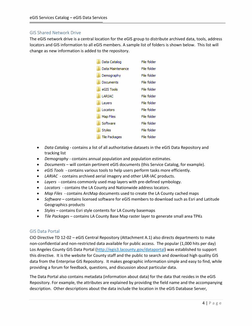
GIS Shared Network Drive The eGIS network drive is a central location for the eGIS group to distribute archived data, tools, address
locators and GIS information to all eGIS members. A sample list of folders is shown below. This list will
change as new information is added to the repository.
Data Catalog - contains a list of all authoritative datasets in the eGIS Data Repository and tracking list
Demography - contains annual population and population estimates.
Documents – will contain pertinent eGIS documents (this Service Catalog, for example).
eGIS Tools - contains various tools to help users perform tasks more efficiently.
LARIAC - contains archived aerial imagery and other LAR-IAC products.
Layers - contains commonly used map layers with pre-defined symbology.
Locators - contains the LA County and Nationwide address locators.
Map Files - contains ArcMap documents used to create the LA County cached maps
Software – contains licensed software for eGIS members to download such as Esri and Latitude Geographics products
Styles – contains Esri style contents for LA County basemaps
Tile Packages – contains LA County Base Map raster layer to generate small area TPKs
GIS Data Portal CIO Directive TD 12-02 – eGIS Central Repository (Attachment A.1) also directs departments to make
non-confidential and non-restricted data available for public access. The popular (1,000 hits per day)
Los Angeles County GIS Data Portal (http://egis3.lacounty.gov/dataportal) was established to support
this directive. It is the website for County staff and the public to search and download high quality GIS
data from the Enterprise GIS Repository. It makes geographic information simple and easy to find, while
providing a forum for feedback, questions, and discussion about particular data.
The Data Portal also contains metadata (information about data) for the data that resides in the eGIS
Repository. For example, the attributes are explained by providing the field name and the accompanying
description. Other descriptions about the data include the location in the eGIS Database Server,

eGIS Services Catalog – eGIS Data Services
5 | P a g e
reference date, accuracy, use and access restrictions, contact information and/or other helpful
information.
Loading and maintaining data in the GIS Data Portal is required as part of the Geospatial Data
Maintenance Agreement. Procedures, as noted earlier, are detailed in the eGIS Data Maintenance
Policies and Procedures (Attachment A.5).
The eGIS Group has developed automated procedures for exporting data from the eGIS Database Server
to locations referenced by the Data Portal to simplify the maintenance of Data Portal entries.
GIS Data Acquisition
Departmental Data Programs Departments establish internal programs to maintain GIS data that are critical to their operations.
These data, however, support operations for many other departments, and the eGIS Program ensures
that departmental data is kept up to date in the GIS Repository and made available Countywide.
Assessor Parcel Data
The Assessor manages parcel data for property assessment and taxation. This data is critical for
decisions about real property, open space, revenue, tax collection, emergency response, and many
other parts of the County’s operations.
Registrar of Voter Precinct/Political District Boundaries
The Registrar/Recorder County Clerk (RRCC), in support of elections, maintains a GIS file of precincts,
which match all political districts in the County, including Supervisorial Districts, State and Congressional
Districts, School Districts, and many more. Over 100 political district boundaries are represented in the
precinct file.

eGIS Services Catalog – eGIS Data Services
6 | P a g e
Public Works Data
The Department of Public Works maintains many GIS datasets related to physical infrastructure,
including storm drain and sewer networks, stream and lake boundaries, street centerlines and other
features of the LA County land base, flood zone boundaries, road closures, and many others. These data
form, in general, the physical infrastructure of the County.
Regional Planning Zoning Data
The Department of Regional Planning maintains zoning information and general plan boundaries that
support the short and long term development priorities of the County. This information is avaialable in
the Repository.
Administrative Boundaries
Departments manage administrative boundaries, from Public Health Planning Areas to the 16 programs
of the Department of Public Social Services. The administrative boundaries delineate the operational
footprint of the County, and are critical to understanding how services are delivered by the County.
eGIS Data Programs
The Chief Information Office and the eGIS Program manage three programs to acquire and update
information that has been determined to be critical, but do not fall under the jurisdiction of an existing
departmental GIS data programd. These datasets add to the richness and diversity of the County’s eGIS
Data Repository as well as enabling County departments to continue to perform research, distribute
information, develop applications, etc. with up-to-date data.
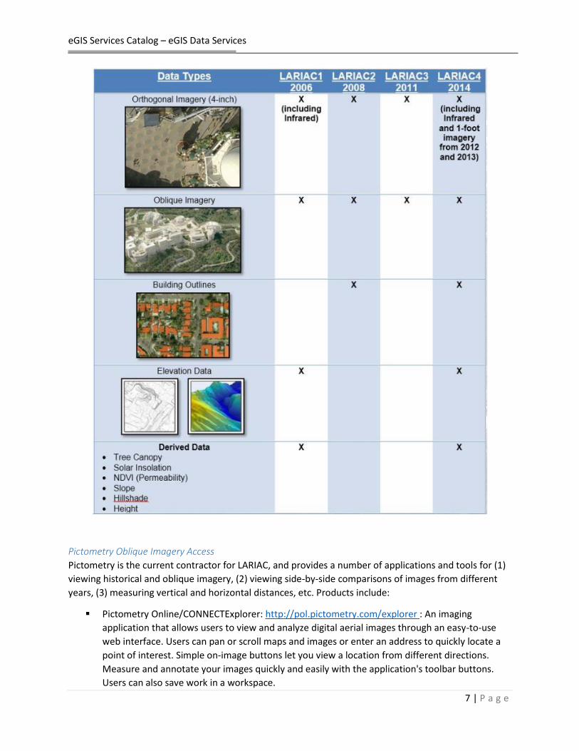
Los Angeles Region Imagery Acquisition Consortium (LARIAC)
The Los Angeles Region Imagery Acquisition Consortium (LARIAC) Program is a collaborative acquisition
program for digital aerial imagery and elevation data which has included the participation of the County
eGIS Program, over 40 cities, and more than 10 other public agencies.
LARIAC is managed by the Chief Information Office which supports the multi-year, multi-agency nature
of LARIAC. The eGIS Program manages funding, storage, and access to LARIAC data for both County
departments as well as LARIAC participating entities.
LARIAC is currently in its fourth round (2014) of imagery acquisition. For more information about
LARIAC, please go to http://egis3.lacounty.gov/dataportal/lariac.
Enterprise GIS subscriptions come with access to all current and historic LARIAC data through all of the
LARIAC data access methods. The eGIS Repository is the primary mechanism for County departments to
access the full range of data that comes from the LARIAC program.
eGIS Services Catalog – eGIS Data Services
7 | P a g e
Pictometry Oblique Imagery Access
Pictometry is the current contractor for LARIAC, and provides a number of applications and tools for (1)
viewing historical and oblique imagery, (2) viewing side-by-side comparisons of images from different
years, (3) measuring vertical and horizontal distances, etc. Products include:
Pictometry Online/CONNECTExplorer: http://pol.pictometry.com/explorer : An imaging
application that allows users to view and analyze digital aerial images through an easy-to-use
web interface. Users can pan or scroll maps and images or enter an address to quickly locate a
point of interest. Simple on-image buttons let you view a location from different directions.
Measure and annotate your images quickly and easily with the application's toolbar buttons.
Users can also save work in a workspace.

eGIS Services Catalog – eGIS Data Services
8 | P a g e
Pictometry CONNECTMobile – A mobile application that provides access to the highest quality
aerial imagery in LA County. Search any address and be instantly presented with the best image
of that location
Pictometry for ArcGIS Desktop – Connect: Integrates Pictometry Oblique imagery into Esri’s
ArcGIS Desktop product. Once the user clicks on a point on the ArcGIS Desktop map, the
extension will open a Pictometry image for the location you clicked on the map. The extension
allows you to visualize your spatial data overlaid on top of the imagery
The eGIS Program creates departmental organizations, and establishes usernames and passwords.
Pictometry provides training for the software and technical support. A representative from Pictometry
can either come out to your department location or host an online training session to train your staff.
The access methods listed above is supplemented by a number of technical methods that require
programming (Pictometry Gateway, Pictometry IPA). For more Pictometry and LARIAC access methods,
see the LARIAC Access Methods web page: http://egis3.lacounty.gov/dataportal/lariac/lariac-access-
methods/.

eGIS Services Catalog – eGIS Data Services
9 | P a g e
Location Management System (LMS)
The Location Management System (LMS) is a collaborative system to manage information about
locations (aka Points of Interest) across the County. The full dataset contains over 73,000 locations,
including 63,000 public and 14,000 non-public locations with consistent attributes. Location types are
broken into more than 270 unique types using three categories (i.e. cat1, cat2, cat3) that provide
detailed breakdowns of the location types.
This dataset supports the County Service Locator, and Enterprise Application that is funded by the eGIS
Program and maintained by the eGIS Group. The Service Locator is described in more detail in the eGIS
Applications Section.
The County has launched an ambitious program to maintain this data collaboratively. Each location in
the dataset has a defined page for it. If the information is incorrect, out of date, or the location is wrong,
registered users can edit the information and provide comments for that location. If any changes were
made, the site will notify the owner of dataset.
For more information about the LMS data, please go to
http://egis3.lacounty.gov/dataportal/2014/07/07/locationspoints-of-interest-lms-data.
Countywide Address Management System (CAMS)
The eGIS Program maintains a system in partnership with RRCC to enhance the County’s address
information. The Countywide Address Management System (CAMS) was created to redesign and expand
an earlier address data model to support a wider variety of location information, including address
points and landmarks, that better meets the County’s needs and more accurately represents the real
world. For details click on this link: http://egis3.lacounty.gov/eGIS/county-gis-projects/address-
management-cams/
CAMS provides:
Full support for distributed, multi-user editing of CAMS data
Editing by other departments, cities, and agencies in the County
Wider interdepartmental maintenance and usage of CAMS street centerline and address data as
a shared resource, and consequently
Integration of many redundant data sets and work flows that exist throughout the County.
The goal of the CAMS project is to expand the use of the CAMS systems and software to those cities and
staff creating and maintaining addresses, such as Engineering and Planning departments. This project
will develop workflow, quality control, distribution, and reporting systems to ensure the highest level of
accuracy within the system. The County of Los Angeles and the jurisdictions that are participants in this
project will see:
Design a Improved address spatial and name quality; Improved timeliness of address updates; Faster and more reliable access to address information; Improved and streamlined work processes across the multiple jurisdictions and agencies that
create addresses; Contemporary technologies providing enhanced information management and service delivery; Reduction in the cost of address maintenance.

eGIS Services Catalog – eGIS Data Services
10 | P a g e
The Enterprise GIS Group has built the CAMS Online Work Order System, a secure online mapping
application for cities and the County to easily identify errors and create work orders for (1) incorrect or
missing addresses, (2) incorrect or missing street labels, (3), incorrect or missing streets, and (4)
discrepancies between various street network datasets.
Within the application, users can create a new work order at a specific location or intersection. Fields
have been built into the work order, and therefore, the user can easily select a category, fill in a
description as well as his/her contact information, and submit it. The County will hire a dedicated staff
to oversee the address update process across the County. A list of key CAMS contacts can be found
here: http://egis3.lacounty.gov/eGIS/county-gis-projects/address-management-cams/cams-contacts/
The CAMS Desktop Application Editor’s Guide is included as Attachment A.6.
Demographic data
The eGIS Group has an annual contract with Hedderson Demographic Services in which annual County of
Los Angeles population and poverty estimates at either the Census Tract level or Census Tract-City split
levels are delivered. The County estimates populations on a yearly basis to improve its understanding of
population shifts so departments can provide services more effectively as populations grow and move.
A large part of the population and poverty estimates are located on the shared network drive described
above. For detailed information of the demography data, please go to:
http://egis3.lacounty.gov/dataportal/2014/09/09/population-and-poverty-estimates.

eGIS Services Catalog – eGIS Data Services
11 | P a g e
Service Level The Enterprise GIS Group maintains a Service Level Agreement (SLA), which outlines the service levels,
roles and responsibilities, a staff matrix, escalation procedures, and terms and conditions governing the
use of and access to eGIS systems.
Details about the eGIS Data Service Levels and staff responsibility matrix can be found in the relevant
section in the SLA.

eGIS Services Catalog – eGIS Data Services
12 | P a g e
eGIS Online Mapping Services Historically, GIS tools resided on powerful desktop machines and were accessible to highly technical
staff. This paradigm has shifted through the deployment of online GIS tools that enable maps, analytical
tools, and GIS capabilities to be accessed through online mapping and online GIS services. This allows
non-GIS systems and to take advantage of the power of GIS, providing GIS capabilities to anyone,
anywhere, at any time.
The eGIS Program maintains a variety of online GIS mapping services and Application Programming
Interfaces (APIs) that developers use to build applications or automate business functions to support the
wide use of GIS tools. These include:
Map Services – Customized, high resolution maps embedded in applications, including cached and dynamic map services.
Geocoding Services – for locating and validating addresses nationwide
Querying services – for searching for geographic features
Routing services – for getting direction and optimizing routes.
Identification Services – for finding administrative districts by address
Optimized Search Services – for rapidly returning information from big data sets.
The eGIS Program also develops, supports, and hosts departmental GIS Mapping Services.
Attachment List Attachment Document Name Description
B.1 Instructions for publishing departmental map services
How departments can publish their own map services
B.2 Web Services Guide Technical Guide for using eGIS custom-built web services (for programmers)
B.3 CIO Recommended Technologies for GIS
A list of technologies recommended by the CIO and the eGIS Committee for GIS infrastructure.
Web Services A web service represents a GIS resource (e.g. map, geocoder) that is located on a central server and is
made available to client applications and/or web browsers to consume. Publishing a web resource
allows one or multiple organizations to simultaneously access and consume the resource.
Esri ArcGIS Server Esri’s ArcGIS Server software is the worldwide leader in deploying GIS tools via web technologies.
ArcGIS Server provides geospatial services through standard communication protocols (JSON, XML,
SOAP, REST) to support GIS capabilities for applications, systems, and programs.
ArcGIS Server effectively web enables the Enterprise GIS Repository – enabling the rapid development of
applications for use by departments to streamline and improve their operations through the inclusion of
GIS capabilities.
Most importantly, ArcGIS Server provides standard methods for accessing GIS capabilities (WMS, WFS,
WMTS, etc). Once a developer understands how to leverage a single service, the developer can use the

eGIS Services Catalog – eGIS Data Services
13 | P a g e
exact same techniques to access any service published through ArcGIS Server, eliminating code
duplication and supporting a shared code repository.
Departmental application developers have access to a rich set of APIs, code samples, and technical
resources to help them leverage the technology and services supported by the eGIS Program.
Map services A map service connects to GIS data located on the eGIS Database Server to make maps, data, and
attributes available to many types of applications. The eGIS group hosts a variety of dynamic and cached
map services for County departments to consume in their web mapping applications.
Cached Map Services Cached map services serve maps very quickly using a cache of pre-drawn static images. Returning an
image tile from the cache takes the server much less time than drawing the map image on demand.
Access to the features and data contained in the map is maintained. Generally cached map services
underlay dynamic map services to provide a context for the information shown in a map. The Google
Map that everyone is familiar with is an example of a cached map service. Cached map services
maintained by the eGIS Program include:
Map Service Name and Description Sample
LACounty_Parcel Parcel Map and accompanying attributes such as ownership, site address, mailing address, property size, and year built.
LACounty_Aerial_XXXX
Imagery Base maps (2002, 2006, 2008, 2011, 2012, 2013, and 2014 aerial photography)

eGIS Services Catalog – eGIS Data Services
14 | P a g e
LACounty_Streetmap Street basemaps which contains street labels, tree canopy, building outlines, addresses, etc.
LACounty_Terrain
Terrain basemap shows elevation and contour lines at the 2-, 10-, and 50-ft intervals.
LACounty_Base
Combined imagery and labelled streets.

eGIS Services Catalog – eGIS Data Services
15 | P a g e
LACounty_Canvas A lighter version of the Street basemap which is optimized for overlays of Dynamic Map Services.
Dynamic Map Services Dynamic map services are displayed in the application when a request is made to the server. As the user
pans around in the mapping application, the service requests new map images from the server to
display. The EGIS Program maintains dynamic map services for many authoritative layers for inclusion in
applications. These follow the same organizational structure as the Enterprise GIS Database Server
databases, with the following services:
1. Administrative Boundaries 2. Basemaps and Grids 3. Demographics 4. Elevation 5. Hazards 6. Hydrology 7. LMS_Data_Public_2014 (Points of Interest) 8. Political Boundaries 9. Street Labels 10. Transportation
Departmental Map Services For departmental applications, departments are able to create and publish their own dynamic map
services to a dedicated folder on the GIS Server. Instructions for doing that are included in Attachment
B.1.
Geocode services Geocoding services translate an address or landmark into a coordinate that can be placed on a map.
The County’s geocoding services connect to the Countywide Address Management System (CAMS) to
find the locations of clients, incidents, infrastructure, and any other address stored in a County system.
County departments maintain millions of records with addresses in them – a geocode service
geospatially enables that information to be mapped, analyzed, and compared with other information.
The Enterprise GIS Program maintains two geocoders (aka Locators)
1. CAMS_Locator – searches for addresses in the County only.

eGIS Services Catalog – eGIS Data Services
16 | P a g e
2. CAMS_Locator_Nationwide – adds a nationwide address search.
Other Uses
Geocoding services can be used to:
1. Validate Addresses – to determine if addresses exist before they are entered into County systems.
2. Clean up addresses – fixing addresses that have incorrect information
3. Reverse geocode – take coordinates and find the relevant address.
4. Unduplicate data – finding two client records in the same location may well show duplicate information.
5. Detect fraud – multiple payments going to the same location with different names may show fraud.
Query and Identification Services Each map service also enables a query and search service that enables applications to query and search
the data that is included in the service, returning information geographically on a map.
Identification services take a coordinate, often returned from a geocode, to find the information
contains in another GIS layer. These services are critical for County departments, since they provide the
foundation for providing service location information to County staff and County constituents. For
example, an identification service is used to identify a County office or Board members that are
responsible for 500 W Temple Street, Los Angeles, CA or to find the nearest fire station to 350 S.
Figueroa Street, Los Angeles, CA.
Routing Services Routing services provide driving directions from one point to another, including drive times and
distances. The County Mileage Authorization & Reimbursement System (MARS) leverages a routing
service from Google (part of the eGIS Program) to make the submission of mileage claim forms easier
and faster, saving thousands of hours of County staff time.
Routing services can also support more advanced capabilities, including determining the most efficient
route for many stops (like the route of a caregiver or mail carrier), or a logistics exercise, determining
the most efficient combination of routes for multiple staff going to multiple locations (like UPS trucks for
example).
Security ArcGIS Server enables map services to be open or secure, supporting token-based authentication to
ensure that confidential or private data is available only to users with the relevant passwords.
Optimized Search Services (Geocortex Instant Search) Latitude Geographics Geocortex (see eGIS Applications for more details) Instant Search technology
supports a highly scalable and extremely fast indexed search engine that provides a fast and intuitive
search across millions of features and associated records. This feature allows end users to see search
suggestions as they are typing what they are looking for (AIN of parcels, cities and communities, Points

eGIS Services Catalog – eGIS Data Services
17 | P a g e
of Interests). As soon as the user enters three characters, a list will immediately appear to suggest, hint,
or predict, what the user is searching for. A maximum of ten selections will appear. The user may
continue typing in the characters if the entry is not there and the Instant Search feature will continue to
give suggestions.
The source for the Instant Search comes from the map services that the eGIS group or departments
publish onto the eGIS servers. Any map service can be indexed and included in the Instant Search.
Custom GIS web services The eGIS group has developed customized GIS web services that involve geocoding, routing, and
identifying. These extend the Esri web services to provide specific functionality for County business
processes enabling faster programming and deployment for eGIS departments.
Current web services support:
Geocoding
Finding district and administrative boundaries from addresses.
Finding parcel information from addresses.
Detailed specifications for developers are included in Attachment B.2 - Web Services Guide.
The Geocode function is designed for applications that require a single matched address (generally
automated computer to computer communication), compared to the GeocodeFindCandidates function
which returns a list of possible matches and which should be used for application developed. In fact,
this service returns the first result from the GeocodeFindCandidates service. LA County reference files
are extremely accurate and in most cases will provide the correct result, but in some cases, two
candidates will have the same score, and this service will select only one. See the Web Services Guide
for technical description and examples of the Geocode and GeocodeFindCandidates web services.

eGIS Services Catalog – eGIS Data Services
18 | P a g e
The Identify web service contains two sets with different goals. The first set has two services that will
return a list of the most commonly requested political districts including:
City or Community Name Supervisorial Congressional State Senate State Assembly State Board of Equalization
The second set of Identify web services covers a number of functions developed to perform a basic
function of Geographic Information Systems – “where am I?” Each function takes the input parameter,
a set of coordinates, and returns a single field/value pair with information about a boundary they are
inside. For example, the GetZipcodeFromXY function returns the zipcode, the GetSPAfromXY returns
the SPA (Service Planning Area).
These functions rely on a generalized back-end function called GenericIdentify which allows new
functions to be implemented very quickly upon request. The functions have been designed so that code
does not need to be changed on both our servers and required minimal change for developers since ALL
response tags are the exactly the same. If you need a specific function, contact the ISD Enterprise GIS
Team.
GIS Web API and GIS Application Development Web Services are only as useful as how they support application development. The Online Mapping
Services the eGIS Program provides can be used by widely adopted Application Programming Interfaces
(APIs), making application development easier, faster, less expensive, reusable, and interoperable. The
Enterprise GIS Steering Committee has developed a number of CIO Preferred Technologies for GIS,
which can help department select the technology they will use for application development. This
document is included as Attachment B.3
Esri Development Tools Esri maintains a large library of APIs, Software Development Kits (SDKs), and tools that enable
programmers to leverage the County’s GIS Mapping Services right away. Replacing their sample map
services with the County’s map services is easy to do and enables departments to begin application
development rapidly.
The Esri Developer page is here: https://developers.arcgis.com/en/
Leaflet For lightweight and mobile applications, Leaflet (http://leafletjs.com/) has distinguished itself as a
simple and powerful library for building simple applications, especially on a mobile platform. It can
leverage both external basemaps from MapBox, Esri, and Google, as well as internal map services. A
number of commercial sites leverage leaflet, which is a valuable addition to the GIS development space.

eGIS Services Catalog – eGIS Data Services
19 | P a g e
Geocortex Additionally, the eGIS Program maintains an enterprise license with Latitude Geographics for the
Geocortex Application Development Framework (more in the next section).
Service Level The Enterprise GIS Group maintains a Service Level Agreement (SLA), which outlines the service levels,
roles and responsibilities, a staff matrix, escalation procedures, and terms and conditions governing the
use of and access to eGIS systems.
Details about the eGIS Online Mapping Service Levels and staff responsibility matrix can be found in the
relevant section in the SLA.

eGIS Services Catalog – eGIS Applications
20 | P a g e
eGIS Countywide Applications The eGIS Program maintains a number of Countywide applications for department and public use. As
well, Technology Directive TD 12-04 – eGIS Central Infrastructure (Attachment C.1) – directs
departments that are building web-based mapping and GIS application to host the mapping capabilities
in the Central GIS Infrastructure managed by the eGIS Group.
Attachment List Attachment Document Name Description
C.1 TD 12-04 – eGIS Central Infrastructure
Directs departments to host GIS capabilities with the eGIS Group.
C.2 Service Locator/LMS Governance Document describing the governance of the Service Locator and Location Management System.
C.3 Accessing your Geocortex Viewer Instructions on how to access the Essentials Manager on ISD’s development server
Service Locator The County’s Service Locator is a web-based locator that allows citizens to find the location and
availability of recreation, health, safety, social services and more. Users may also (1) get contact
information for your local government representatives, (2) get additional information for all county
services and facilities, and (3) print driving directions to and from LA County facilities.

eGIS Services Catalog – eGIS Applications
21 | P a g e
To access the County’s Services Locator, go to http://maps.lacounty.gov.
Governance of the Services Locator and the related Location Management System (discussed in the eGIS
Data Services section) is detailed in Attachment C.2 - Services Locator - LMS Governance. Kimberly Jo
from the Chief Information Office oversees the Governance of the Service Locator. She can be
contacted at [email protected]
District Locator The Enterprise GIS Group has developed a simple web-based locator that allows citizens and staff to find political districts (e.g. supervisorial district, congressional district, state assembly district, state senate district) based on an address. This provides district and the public with authoritative information about administrative districts, which reduces staff time used to determine the correct contact for a resident.
To access the County’s District Locator, go to http://gis.lacounty.gov/districtlocator.

eGIS Services Catalog – eGIS Applications
22 | P a g e
GIS Viewer The LA County GIS Viewer (http://gis.lacounty.gov/gisviewer) was created by the Chief Information
Office and the eGIS Group at ISD. The objective of the GIS Viewer is to publicize the County’s GIS
authoritative data holdings and enable wide access to them through a powerful set of web-based GIS
tools. The audience is mainly targeted to internal County employees but it is also available to the public.
Free training on the GIS Viewer is available as part of the Enterprise GIS Training and Support Services.
Please see Section E (Training and Support Services) for descriptions and training manuals for the GIS
Viewer.
Users can explore geographic information, perform basic GIS functions, perform spatial queries, and
leverage the power of GIS:
GIS Functions
- Pan - Add shapefile(s) to the viewer
- Zoom in and out - Plot coordinates
- Identify features - Generate elevation profiles
- Search by attribute(s) such as AIN and owner name
- Set transparency of layers
- Measure distance and area - Buffer features
- Create aesthetic maps for printing, saving and/or exporting
- Perform simple and advanced spatial queries
- Create text and markups - Launch Bing and Google Street View from its current spatial location

eGIS Services Catalog – eGIS Applications
23 | P a g e
The GIS Viewer offers three custom reports and these reports can be saved and printed: (1) a parcel
summary report with a map, (2) a parcel summary report without a map, and (3) mailing labels of
owners.
The GIS Viewer was built using Latitude Geographics’ Geocortex Viewer for Silverlight (more information
on this application framework below).
To access the County’s GIS Viewer, go to http://gis.lacounty.gov/gisviewer.
Parcel viewer The County’s Parcel Viewer was developed by the eGIS group at ISD. Users can access parcel information
(including ownership information) and LARIAC data through the County’s Parcel Viewer, a secured
online web mapping application.
Free training on the Parcel Viewer is available as part of the Enterprise GIS Training and Support
Services. Please see Section E (Training and Support Services) for descriptions and training manuals for
the Parcel Viewer.
Users can explore geographic phenomena, perform basic GIS functions, perform spatial queries, and
leverage the power of GIS:
GIS Functions - Pan - Add shapefile(s) to the viewer
- Zoom in and out - Plot coordinates
- Identify features - Generate elevation profiles

eGIS Services Catalog – eGIS Applications
24 | P a g e
- Search by attribute(s) such as AIN and owner name
- Set transparency of layers
- Measure distance and area - Buffer features
- Create aesthetic maps for printing, saving and/or exporting
- Perform simple and advanced spatial queries
- Create text and markups - Launch Bing and Google Street View from its current spatial location
Custom parcel reports can be generated, saved, and printed. The three reports include a parcel
summary with a map, mailing labels of owners, and mailing labels of residents. Parcel attributes may be
exported as a .csv file to create brand specific mailing labels.
The application is available to eGIS and LARIAC members. The site is password protected – email
[email protected] to get your credentials. To access the County’s Parcel Viewer, please go to
http://gis.lacounty.gov/parcelviewer.
Latitude Geographics Geocortex Application Development Framework The Enterprise GIS Program maintains an enterprise license with Latitude Geographics, a company that
develops a number of software tools (Geocortex Essentials, Optimizer, etc) that support rapid
development of powerful web-GIS applications. These applications include the GIS Viewer and Parcel
viewers described above.
The license entitles the County to unlimited Geocortex Essentials, Optimizer, Workflow Designer, and
Report Designer installations that support Countywide applications. The eGIS group installs the latest
versions of Geocortex on the development server for GIS analysts and developers to use. Currently,
departments can deploy as many Viewer for Silverlight or HTML5 applications onto their own
department directory.
To gain access to the Geocortex Essentials Manager site on an ISD development server, please contact
[email protected] with your employee number. An instructional document called “Accessing your
Geocortex Viewer” (see Attachment C.3 for example without login credentials) will be emailed to you.

eGIS Services Catalog – eGIS Applications
25 | P a g e
Application Hosting and Monitoring The eGIS group at ISD supports hosting of departmental GIS applications and mapping systems. The
eGIS group generally follows the technology recommendations listed in Attachment B.3 – CIO Preferred
Technologies for GIS. It is recommended that departments start from that list as they begin to develop
applications.
There is no extra cost for eGIS member departments to host applications within the eGIS infrastructure.
The eGIS group also provides a development server for GIS analysts and developers to build and test
their application(s) prior to deployment into production.
eGIS members have access to the most current versions of software on the development server. The
servers are professionally managed by Windows System Engineers, Midrange Computing Division,
eCloud, System Security, and the eGIS group. Together, the ISD staff provides high levels of security
expertise, monitoring, and support for all of our applications.
Monitoring The County of Los Angeles licenses monitoring applications that allow administrators and GIS managers
to oversee the performance of severs, software, license, and applications.
Optimizer The eGIS group has installed a monitoring application, called Optimizer, on production servers which
allows the capture of information about ArcGIS Server sites and infrastructure. At any point, users may
check the status of map services and get general statistics such as the server CPU usage, server memory
usage, number of map requests made, number of hits to all Geocortex viewers (Silverlight and HTML5),
etc.
Please contact the eGIS group ([email protected]) to get access to Optimizer.
Mobile There is no doubt that mobile technology is quickly growing as well as its use to view, capture, analyze,
and edit data on the fly in the field. Traditionally, spatial information has been taken to the field using

eGIS Services Catalog – eGIS Applications
26 | P a g e
paper maps, compasses, handheld GPS units, etc. and then taken back to the office to upload the data
collection. This process was deemed too inefficient and costly. Desktop GIS applications are moving
toward mobile-friendly devices. It should not be considered a replacement, but rather, an extension
because desktop GIS continues to offer many features and capabilities that HTML5 do not have.
The eGIS group has been participating in this mobile transformation, and has developed and hosted
mobile applications (built on HTML5, JavaScript, CSS) for County departments to collect and/or edit field
data. The mobile applications work on a variety of platforms (e.g. smart phones, tablets) and operating
systems (e.g. android, Apple). These applications deliver powerful, yet lightweight GIS to the end users.
Service Level The Enterprise GIS Group maintains a Service Level Agreement (SLA), which outlines the service levels,
roles and responsibilities, a staff matrix, escalation procedures, and terms and conditions governing the
use of and access to eGIS systems.
Details about the eGIS Countywide Application Service Levels and staff responsibility matrix can be
found in the relevant section in the SLA.

eGIS Services Catalog – eGIS License Management Services
27 | P a g e
eGIS License Management Services The eGIS Program maintains several countywide license agreements for GIS related software. This
supports cost reductions through the optimization of license and service utilization.
CIO Technology Directive TD 12-03 - EGIS Centralized Software Management (Attachment D.1)
establishes the Enterprise GIS program as the manager of the countywide software maintenance
agreement with Esri, the primary desktop GIS software vendor.
Attachment List Attachment No.
Document Name Description
D.1 TD 12-03 eGIS Centralized Software Management
Establishes the eGIS Program as the holder of the Countywide software license agreement
D.2 Esri Master Purchase Agreement Fully executed Master Purchase agreement with software price list (Exhibit D of the MPA)
D.3 Esri Software MPA attachment purchase rider
Form used to inform ISD that the MPA exists and sole source justifications are not necessary
Esri License Transfer forms available as necessary
Mechanism to transfer licenses from departmental agreement to Countywide agreement
Esri Software Esri is the world leader in desktop GIS software, and is the recommended desktop GIS software within
the County (see Attachment B.3 – CIO Preferred Technologies for GIS).
The Enterprise GIS Program maintains a countywide enterprise maintenance agreement with Esri, as
well as a Master Purchase Agreement that provides discounts for new software purchases (see
Attachment D.2). Departments that purchase Esri software can leverage the MPA purchase rider to
avoid sole source justifications (Attachment D.3)
Regardless of whether a department subscribes to the eGIS Services, all Esri software licenses, both
current and discontinued, have been transferred from Department (Customer Number) to the eGIS
Program. This agreement, managed by ISD, provides opportunities for GIS licensing cost savings. Forms
to complete these transfers are available as needed.
Departments continue to have access to all software listed unless mutually agreed upon, and ongoing
costs for license maintenance and additional software purchases are passed back to departments
through ISD Service Requests.
The eGIS Program provides software updates and installation packages to departments for installation,
and has arranged with Esri to provide a backup license and authorization file to departments for a
backup license server in case there is a network disruption.
Esri Software Usage Monitoring – OpenLM OpenLM software provides usage reports on Esri ArcGIS Desktop software and extensions to find out
which persons have Esri ArcMap opened, who have checked out an ArcGIS license (e.g. Spatial Analyst)

eGIS Services Catalog – eGIS License Management Services
28 | P a g e
how long they have used it, but current and historically. OpenLM allows System administrators can
retrieve licenses either manually or automatically.
To get access to OpenLM, please contact the eGIS group at [email protected].
Esri ArcGIS Online As part of its software maintenance agreement, the County of Los Angeles has a central account with
Esri’s cloud platform, ArcGIS Online, which is managed by the eGIS group at ISD. eGIS members may
request an account to (1)publish spatial data and map services online, (2) share maps, (3) create data,
and (4) create applications. ArcGIS Online uses a service credit system and charges for routing, driving
times, demographic and lifestyle maps, elevation analysis, and much more. The geocoding capability has
been linked with the County’s Locator. The eGIS group monitors credit usage by department.
For a full list of ArcGIS Online services that utilize credits, please see:
http://www.esri.com/software/arcgis/arcgisonline/credits
Google Maps API The Enterprise GIS Program administers an annual license for Google Maps API for Work, with costs
allocated to departments that leverage the Google Maps API based upon the number of map draws. A
single license eliminates duplicate billing, and establishes better volume pricing.
eGIS member departments are able to build applications for web browsers, mobile devices, or custom
applications using a license for the Google Maps API. This agreement currently allows up to 1,000,000
public map loads per year. Several Web Service APIs are included in this package: Gecoding API,
Directions API, Distance Matrix API, Elevation API, and Time Zone API (usage limits may apply).
The Google license comes in two flavors – public and internal facing applications. There is a different
price per map draw for each of these two different licenses.
For more information, go to https://developers.google.com/maps/documentation/business.
Microsoft Bing The County of Los Angeles has an annual license agreement with Microsoft Bing Maps Platform API. The
license covers 100,000 transactions per month for public-facing websites which are shared amongst all
eGIS member departments. API options may include Geocoding API, Directions API, Search API, Imagery
API, Localization Support API, etc.

eGIS Services Catalog – eGIS License Management Services
29 | P a g e
For more information, go to http://www.microsoft.com/maps/default.aspx.
Service Level The Enterprise GIS Group maintains a Service Level Agreement (SLA), which outlines the service levels,
roles and responsibilities, a staff matrix, escalation procedures, and terms and conditions governing the
use of and access to eGIS systems.
Details about the eGIS License Management Service Levels and staff responsibility matrix can be found
in the relevant section in the SLA.

eGIS Services Catalog – eGIS Training and Support Services
30 | P a g e
eGIS Training and Support Services To help departments subscribing to Enterprise GIS services take full advantage of the both their Desktop
web-based GIS toolsets, the Enterprise GIS Program provides training for staff as well as support hours
for questions and technical support (four percent of overall subscription costs).
Attachment List Attachment No.
Document Name Description
E.1 LA County GIS Viewer Manual Training manual for the GIS Viewer
E.2 LA County Parcel Viewer Manual Training manual for the Parcel Viewer
GIS Training Training for Esri’s ArcGIS Desktop software is included at no cost to department staff who enroll in the
eGIS membership program. This includes a beginner’s course and an intermediate course and they focus
on accessing datasets in the eGIS repository and map services, creating maps, geocoding using the
County’s locator, and performing basic spatial analyses (e.g. buffer, clip, join tables). The manual is
available upon request.
No-cost training for the County’s GIS Viewer (http://gis.lacounty.gov/gisviewer) and Parcel Viewer
(http://gis.lacounty.gov/parcelviewer) are also available. Attendees will learn how to navigate the
viewers, search for data, create reports, generate basic queries, print maps, geocode a small list of
addresses, etc.
The training manuals for the LA County GIS Viewer and Parcel Viewer are included as attachments E.1
and E.2, respectively.
Specialized training can be developed for departments as part of GIS Development services. The eGIS
group will provide an estimate/quote based upon requirements.
Customer Support Each department that enroll in the eGIS membership is provided a number of support hours that equate
to 4% of their eGIS subscription budget. These hours can be used for technical support, application
development, ad-hoc analysis, map creation, troubleshooting, and/or additional training.
Additional services can be performed when support hours have run out and the hourly rate at the
current ISD rate.
Departments that do not subscribe to eGIS can request GIS services by leveraging eGIS Consulting
Services.
For more information, go to http://www.microsoft.com/maps/default.aspx.
Service Level The Enterprise GIS Group maintains a Service Level Agreement (SLA), which outlines the service levels,
roles and responsibilities, a staff matrix, escalation procedures, and terms and conditions governing the
use of and access to eGIS systems.

eGIS Services Catalog – eGIS Training and Support Services
31 | P a g e
Details about the eGIS Training and Support Service Levels and staff responsibility matrix can be found in
the relevant section in the SLA.

eGIS Services Catalog – eGIS Training and Support Services
32 | P a g e
GIS Solutions The eGIS Group provides support to many departments with additional services that go beyond the scope
of the standard GIS Services, including custom map creation, GIS application development, geographic
analysis, support of in-house applications, and advanced training. Requests are made through the ISD
Service Request (see Attachment E.1 for example) and sent to your eGIS Representative or to the GIS
Section Manager.
Attachment List Attachment No.
Document Name Description
F.1 ISD Service Request Sample
F.2
Custom maps The eGIS Group can assist in the creation of aesthetic or informational maps and in a variety of sizes for
all County departments. Maps can show trends, intensity, hot spots, and other useful information that
may not be clearly visible from looking at data tables. If your department does not have an in-house
mapping expertise and infrastructure, the ISD eGIS Group can create maps for you.
The eGIS Group can also create ArcMap templates pre-loaded with base maps and your department-
specific datasets for your staff to use. This goal here is give your staff a head start into using GIS without
searching through all the folders to find relevant spatial data.
The eGIS group has two color plotters (HP Designjets 500ps and Z6100ps) in house that can print up to
60 inches in width (length can vary). The printing of maps are at an additional cost. The eGIS Group is
not responsible for the physical service of hanging maps on your walls – please contact your
Department’s Facilities Operations Service.
For cartographic map samples, see http://egis3.lacounty.gov/GISSolutions/MapSamples.html
Custom scripts and tools The eGIS Group has programmers that can create custom scripts and tools for your department GIS
needs. A GIS function that you are looking for may not be available in the toolbox or there are too many
complex steps involved in getting the answer you need. Therefore, a script is needed to add specific
functionality to your application, geoprocessing, or expedite data analysis. Scripts and tools can be
written in python or .NET and can be reused by other departments, thereby saving time on many GIS
tasks commonly used across the County.
For sample scripts and tools, see http://egis3.lacounty.gov/GISSolutions/ScriptsToolsSamples.html
Analysis and Research The use of GIS promotes spatial knowledge, awareness, and increased understanding of the social or
physical phenomenon being studied. GIS can help us explore spatial trends in data that may not be
clearly visible. The eGIS group can perform spatial analysis on your datasets to discover relationships,
patterns, and trends and results are visually displayed and organized on a map.
Examples:

eGIS Services Catalog – eGIS Training and Support Services
33 | P a g e
Topological and geographic properties can be utilized to view service trends to help efficiently distribute services and resources.
Forecasts of detailed population characteristics including income, employment, migration trends, etc. at the regional, county, and census tract levels
Examine the dependence of one variable on one or more independent variables
Track the rate of a disease spreading and predict areas that will soon be impacted
If you are interested in this type of service or would like more information, email
Application development GIS technologies have been applied to diverse fields to assist professionals in collecting spatial data,
analyzing data, and mapping the results. Developers within the eGIS group can build or customize your
own web application to work with your GIS services, workflows, and datasets. Custom GIS application
services include:
Integrated mapping for websites, mobile devices, or lobby kiosks
Identity matching capabilities
Decision-making analysis and tools
Improved functionality including Bing Maps, Google and Esri APIs map controls and services
For eGIS department members, applications will be hosted on eGIS production servers at no extra cost.
If you are interested in this type of service or would like more information, email [email protected].
Service Level The Enterprise GIS Group maintains a Service Level Agreement (SLA), which outlines the service levels,
roles and responsibilities, a staff matrix, escalation procedures, and terms and conditions governing the
use of and access to eGIS systems.
Details about the eGIS Training and Support Service Levels and staff responsibility matrix can be found in
the relevant section in the SLA.

eGIS Services Catalog – GIS Solutions
34 | P a g e
Attachments