the application of terrestrial laser scanner surveys … · the application of terrestrial laser...
TRANSCRIPT
7th Australian Small Bridges Conference, Melbourne, Victoria 2015
1
THE APPLICATION OF TERRESTRIAL LASER SCANNER SURVEYS FOR DETAILED INSPECTION OF BRIDGES
Azimah Arbi, Design Engineer,
Kevin Ide, Experienced Surveyor
Aurecon Australasia Pty Ltd, Australia
ABSTRACT
Bridges are usually inspected by an experienced Engineer/s gaining access with an elevated work platform (EWP) or similar under bridge equipment (UBE). Detailed inspections, typically undertaken concurrently with the load assessment of the structure, require site verification of member sizes and span dimensions. Operational and safety constraints often impact upon the costs associated with this site work in addition to the quantity and quality of site proving captured. There is no legacy value in site measurements acquired in this manner, and any requirement for additional information requires returning to site which is detrimental to project cost and delivery. The Aurecon Spatial Team has made a commitment to exploring engineering application of new technologies and has invested in acquiring Terrestrial Laser Scanning experience since it’s early inception to the marketplace. In close collaboration with the Bridge Design Team, Aurecon has introduced, and is continuing to evolve, innovative methodologies using Terrestrial Laser Scan Surveys. Our objective is to generate a rapid, high definition point cloud of the bridge to capture defects and measurement of member sizes to overcome the issues related to incomplete inspection and survey. Once back in the office the Point Cloud dataset provides comprehensive desk top review capability beyond single or costly multiple site inspections. It also reduces Occupation Health and Safety (OH&S) risks associated with waterway access and high lift equipment. This paper will discuss the benefit of the use of Terrestrial Laser Scan Surveys in a range of bridge projects.
INTRODUCTION
Fundamental in Aurecon’s commitment to Laser Scanning technologies is the concept of rapid “whole” capture and its legacy value in comparison to implementation of conventional site measurements.
There will always be a balance between initial “Up-front” cost of site investigations and provision for contingency costing for missing data that may require subsequent inspections. Through our experience in deployment of Laser Scanning on a wide range of small bridge projects, it has been identified that there is real value and client savings that can be realised through the adoption of a “Whole Capture” strategy. In comparison to conventional site data collection, a single dataset can be re-utilized for extended investigations, some of which may be un-foreseen initially.
7th Australian Small Bridges Conference, Melbourne, Victoria 2015
2
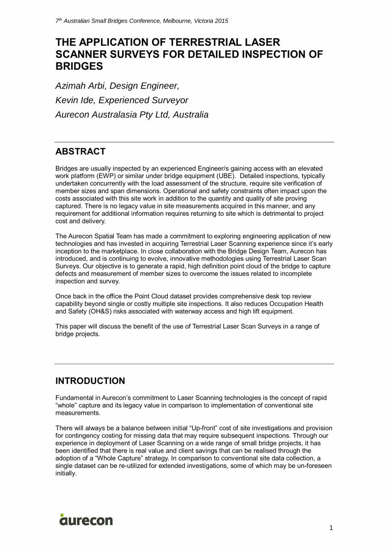
Cost burden in access support to accommodate additional site investigations
Value saving increase from Legacy scan data return
In reality, where direct site inspection access to critical components is constrained and necessitates significant external support and OHS systems, the up-front cost value of scan deployment is typically reasonably comparable. The value then of potential legacy savings through versatility gained through the application of scan based information is genuine. Examination of these benefits is highlighted in the following case studies.
PROJECT – RAIL BRIDGE RENEWAL PROGRAM – METRO TRAINS MELBOURNE (MTM) - 2011
Metro Trains Melbourne implemented a program to renew the bridge superstructure for some of the bridges. These bridges are all located on operational tracks and the replacement program does not permit extended closure of the tracks. The bridge superstructure replacement is required to be undertaken over a weekend occupation. Therefore it was critical to determine as accurately as possible the existing dimensions of the structure so that implementation can be undertaken without any delay during the weekend occupation. A variety of Rail Bridges was included in scope including:
4 Numbers of rail over road structures;
One rail over a waterway;
2 Numbers pedestrian overpass structures; and
One subway underpass structure At all sites demand for certainty in critical dimensioning was high, while accessibility for direct engineering inspections was limited due to road, rail, pedestrians and waterway crossings. Adequate capture of nominated measurements by conventional survey methodologies from safe areas alone was, in some instances, limited. For example; accurate measurement of abutment shelf and fender wall arrangements which were partially obscured or otherwise poorly identifiable from ground level. Integration of Laser Scan site detail capture provided not only a capability to capture areas of poor visibility through electromagnetic laser acquisition, but also provided a secondary dataset that could be cross verified to conventional manual and theodolite based measurements. This composite approach provided a high degree of confidence that existing bridge geometry could be accurately defined ensuring that the prefabricated new bridge deck fitted the existing geometry. This also helped estimate any vertical misalignment of the abutments possibly due to
7th Australian Small Bridges Conference, Melbourne, Victoria 2015
3
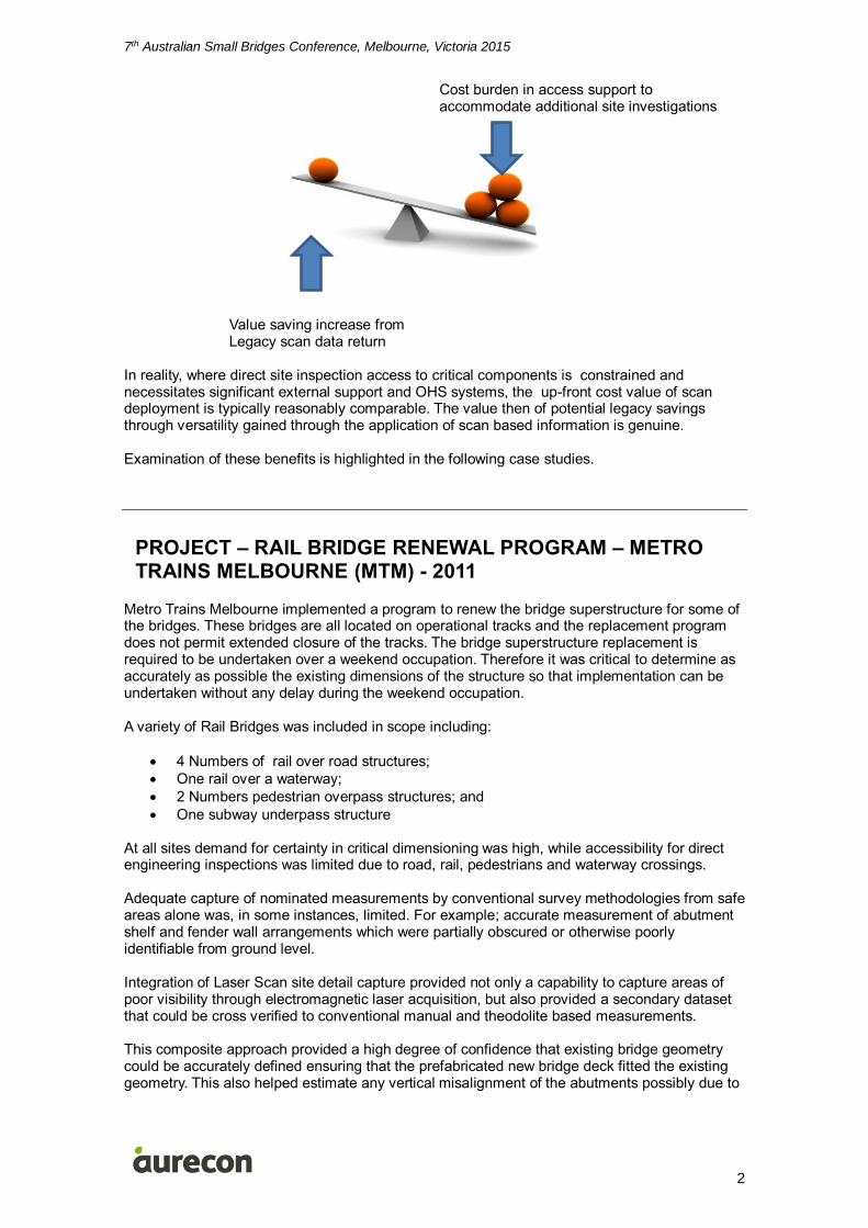
horizontal movements occurred during the life of the bridge. This form of survey enabled the designers to obtain any necessary additional information from the desktop without having to do any additional surveys that could be costly as well as generating a repository of detailed under structure model data. The cloud survey model generated for Victoria Street Bridge is shown in Figure 1 below:
Figure 1: Point Cloud survey model for Victoria Street Bridge.
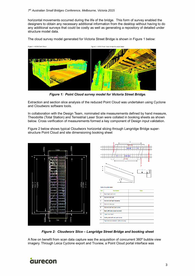
Extraction and section slice analysis of the reduced Point Cloud was undertaken using Cyclone and Cloudworx software tools. In collaboration with the Design Team, nominated site measurements defined by hand measure, Theodolite (Total Station) and Terrestrial Laser Scan were collated in booking sheets as shown below. Cross verification of measurements formed a key component of Design input validation.
Figure 2 below shows typical Cloudworx horizontal slicing through Langridge Bridge super-structure Point Cloud and site dimensioning booking sheet
Figure 2: Cloudworx Slice – Langridge Street Bridge and booking sheet
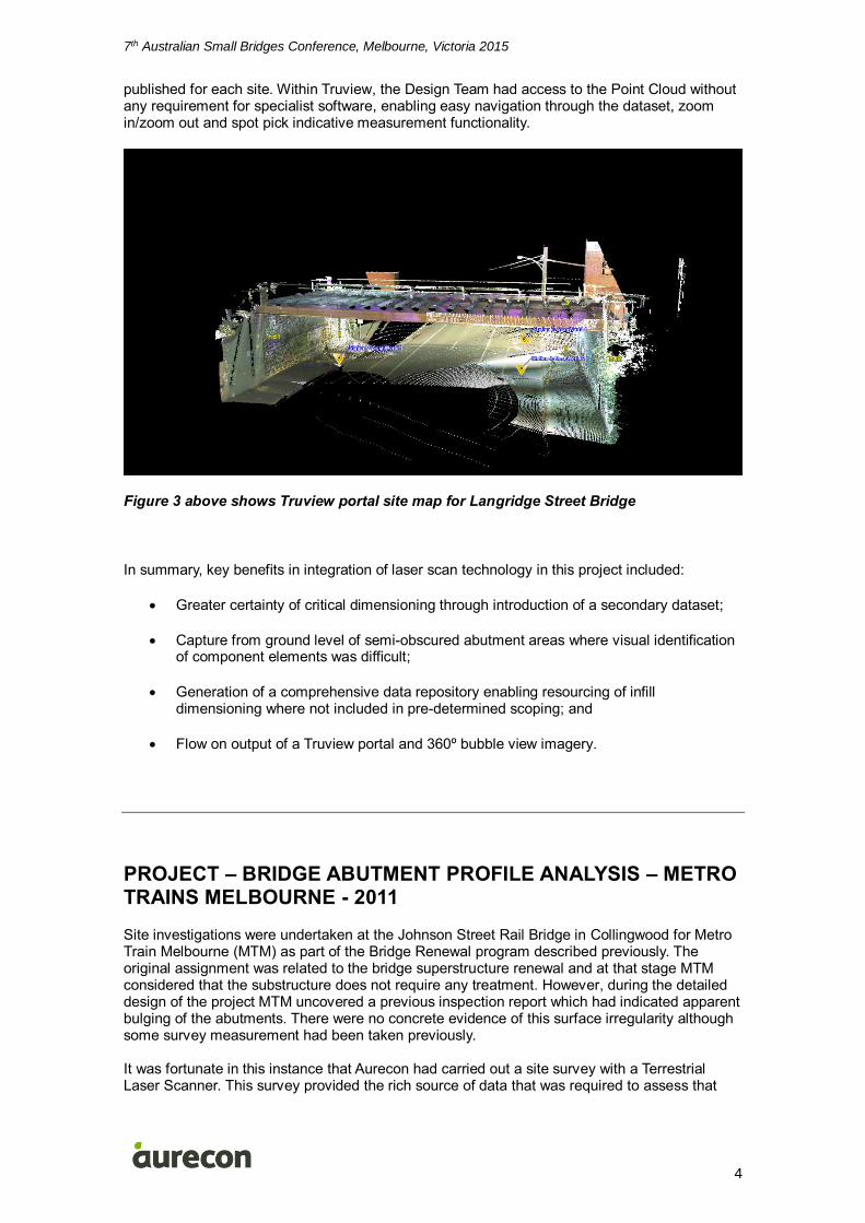
A flow on benefit from scan data capture was the acquisition of concurrent 360º bubble view imagery. Through Leica Cyclone export and Truview, a Point Cloud portal interface was
7th Australian Small Bridges Conference, Melbourne, Victoria 2015
4
published for each site. Within Truview, the Design Team had access to the Point Cloud without any requirement for specialist software, enabling easy navigation through the dataset, zoom in/zoom out and spot pick indicative measurement functionality.
Figure 3 above shows Truview portal site map for Langridge Street Bridge
In summary, key benefits in integration of laser scan technology in this project included:
Greater certainty of critical dimensioning through introduction of a secondary dataset;
Capture from ground level of semi-obscured abutment areas where visual identification of component elements was difficult;
Generation of a comprehensive data repository enabling resourcing of infill dimensioning where not included in pre-determined scoping; and
Flow on output of a Truview portal and 360º bubble view imagery.
PROJECT – BRIDGE ABUTMENT PROFILE ANALYSIS – METRO TRAINS MELBOURNE - 2011
Site investigations were undertaken at the Johnson Street Rail Bridge in Collingwood for Metro Train Melbourne (MTM) as part of the Bridge Renewal program described previously. The original assignment was related to the bridge superstructure renewal and at that stage MTM considered that the substructure does not require any treatment. However, during the detailed design of the project MTM uncovered a previous inspection report which had indicated apparent bulging of the abutments. There were no concrete evidence of this surface irregularity although some survey measurement had been taken previously. It was fortunate in this instance that Aurecon had carried out a site survey with a Terrestrial Laser Scanner. This survey provided the rich source of data that was required to assess that
7th Australian Small Bridges Conference, Melbourne, Victoria 2015
5
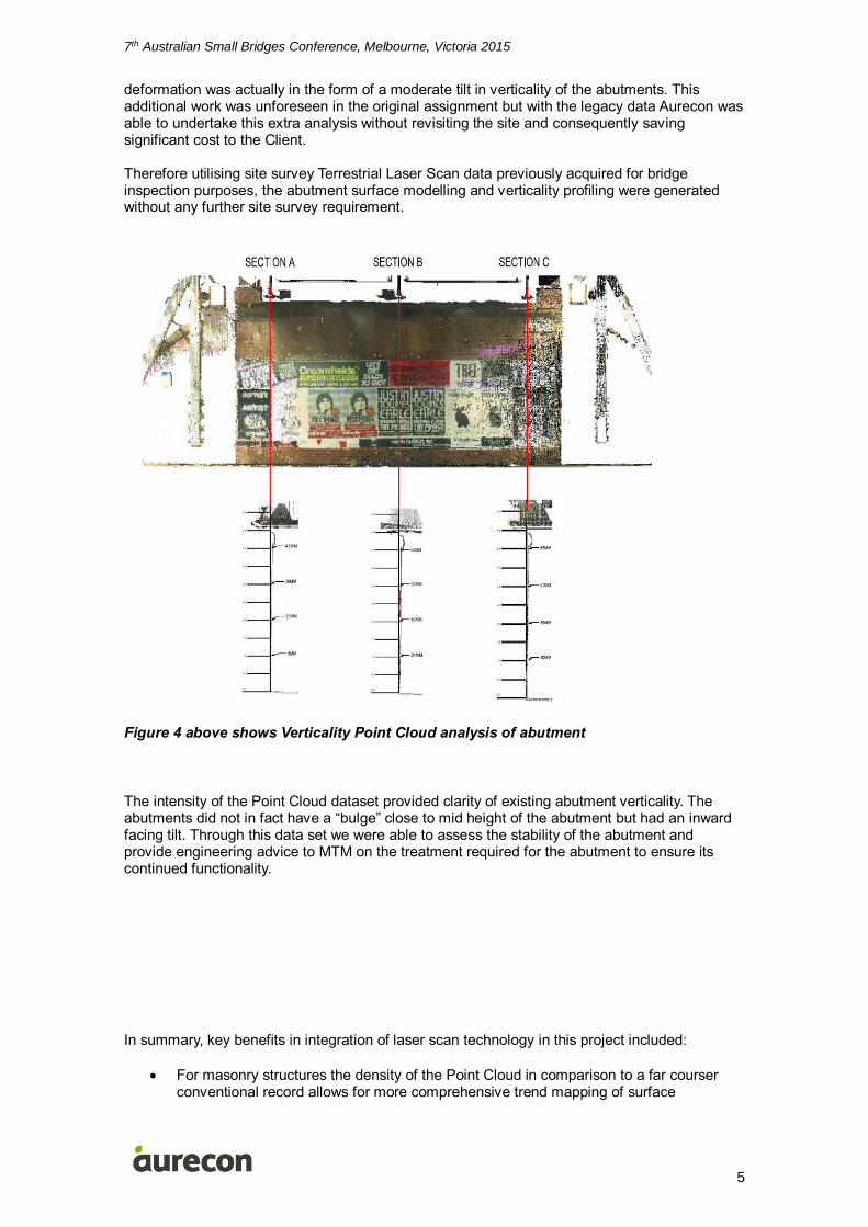
deformation was actually in the form of a moderate tilt in verticality of the abutments. This additional work was unforeseen in the original assignment but with the legacy data Aurecon was able to undertake this extra analysis without revisiting the site and consequently saving significant cost to the Client. Therefore utilising site survey Terrestrial Laser Scan data previously acquired for bridge inspection purposes, the abutment surface modelling and verticality profiling were generated without any further site survey requirement.
Figure 4 above shows Verticality Point Cloud analysis of abutment
The intensity of the Point Cloud dataset provided clarity of existing abutment verticality. The abutments did not in fact have a “bulge” close to mid height of the abutment but had an inward facing tilt. Through this data set we were able to assess the stability of the abutment and provide engineering advice to MTM on the treatment required for the abutment to ensure its continued functionality.
In summary, key benefits in integration of laser scan technology in this project included:
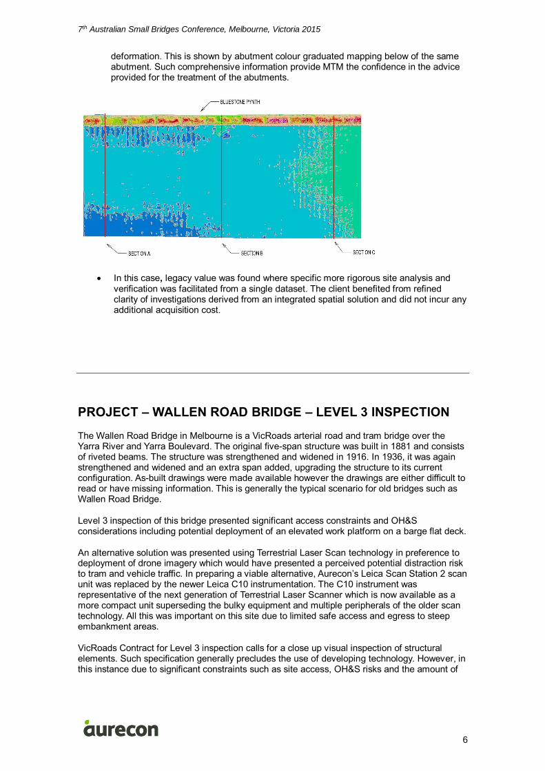
For masonry structures the density of the Point Cloud in comparison to a far courser conventional record allows for more comprehensive trend mapping of surface
7th Australian Small Bridges Conference, Melbourne, Victoria 2015
6
deformation. This is shown by abutment colour graduated mapping below of the same abutment. Such comprehensive information provide MTM the confidence in the advice provided for the treatment of the abutments.
In this case, legacy value was found where specific more rigorous site analysis and verification was facilitated from a single dataset. The client benefited from refined clarity of investigations derived from an integrated spatial solution and did not incur any additional acquisition cost.
PROJECT – WALLEN ROAD BRIDGE – LEVEL 3 INSPECTION
The Wallen Road Bridge in Melbourne is a VicRoads arterial road and tram bridge over the Yarra River and Yarra Boulevard. The original five-span structure was built in 1881 and consists of riveted beams. The structure was strengthened and widened in 1916. In 1936, it was again strengthened and widened and an extra span added, upgrading the structure to its current configuration. As-built drawings were made available however the drawings are either difficult to read or have missing information. This is generally the typical scenario for old bridges such as Wallen Road Bridge.
Level 3 inspection of this bridge presented significant access constraints and OH&S considerations including potential deployment of an elevated work platform on a barge flat deck.
An alternative solution was presented using Terrestrial Laser Scan technology in preference to deployment of drone imagery which would have presented a perceived potential distraction risk to tram and vehicle traffic. In preparing a viable alternative, Aurecon’s Leica Scan Station 2 scan unit was replaced by the newer Leica C10 instrumentation. The C10 instrument was representative of the next generation of Terrestrial Laser Scanner which is now available as a more compact unit superseding the bulky equipment and multiple peripherals of the older scan technology. All this was important on this site due to limited safe access and egress to steep embankment areas.
VicRoads Contract for Level 3 inspection calls for a close up visual inspection of structural elements. Such specification generally precludes the use of developing technology. However, in this instance due to significant constraints such as site access, OH&S risks and the amount of
7th Australian Small Bridges Conference, Melbourne, Victoria 2015
7
onsite measurements to be gathered, VicRoads agreed to the use of scanner technology tothe pick up the key dimensions.
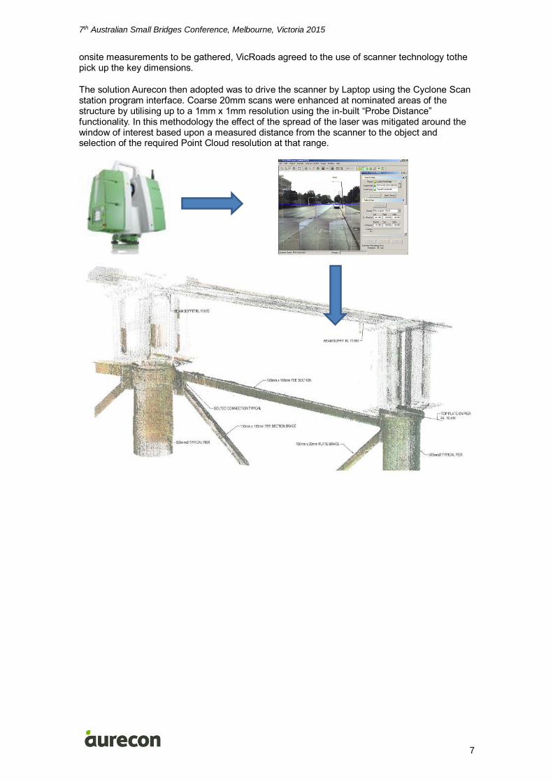
The solution Aurecon then adopted was to drive the scanner by Laptop using the Cyclone Scan station program interface. Coarse 20mm scans were enhanced at nominated areas of the structure by utilising up to a 1mm x 1mm resolution using the in-built “Probe Distance” functionality. In this methodology the effect of the spread of the laser was mitigated around the window of interest based upon a measured distance from the scanner to the object and selection of the required Point Cloud resolution at that range.
7th Australian Small Bridges Conference, Melbourne, Victoria 2015
8
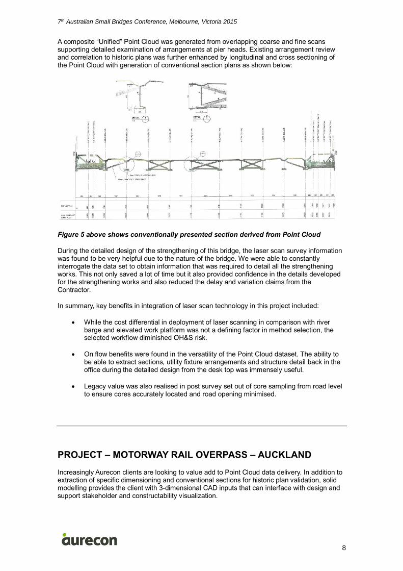
A composite “Unified” Point Cloud was generated from overlapping coarse and fine scans supporting detailed examination of arrangements at pier heads. Existing arrangement review and correlation to historic plans was further enhanced by longitudinal and cross sectioning of the Point Cloud with generation of conventional section plans as shown below:
Figure 5 above shows conventionally presented section derived from Point Cloud
During the detailed design of the strengthening of this bridge, the laser scan survey information was found to be very helpful due to the nature of the bridge. We were able to constantly interrogate the data set to obtain information that was required to detail all the strengthening works. This not only saved a lot of time but it also provided confidence in the details developed for the strengthening works and also reduced the delay and variation claims from the Contractor.
In summary, key benefits in integration of laser scan technology in this project included:
While the cost differential in deployment of laser scanning in comparison with river barge and elevated work platform was not a defining factor in method selection, the selected workflow diminished OH&S risk.
On flow benefits were found in the versatility of the Point Cloud dataset. The ability to be able to extract sections, utility fixture arrangements and structure detail back in the office during the detailed design from the desk top was immensely useful.
Legacy value was also realised in post survey set out of core sampling from road level to ensure cores accurately located and road opening minimised.
PROJECT – MOTORWAY RAIL OVERPASS – AUCKLAND
Increasingly Aurecon clients are looking to value add to Point Cloud data delivery. In addition to extraction of specific dimensioning and conventional sections for historic plan validation, solid modelling provides the client with 3-dimensional CAD inputs that can interface with design and support stakeholder and constructability visualization.
7th Australian Small Bridges Conference, Melbourne, Victoria 2015
9
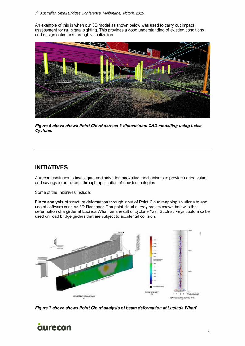
An example of this is when our 3D model as shown below was used to carry out impact assessment for rail signal sighting. This provides a good understanding of existing conditions and design outcomes through visualization.
Figure 6 above shows Point Cloud derived 3-dimensional CAD modelling using Leica Cyclone.
INITIATIVES
Aurecon continues to investigate and strive for innovative mechanisms to provide added value and savings to our clients through application of new technologies.
Some of the Initiatives include:
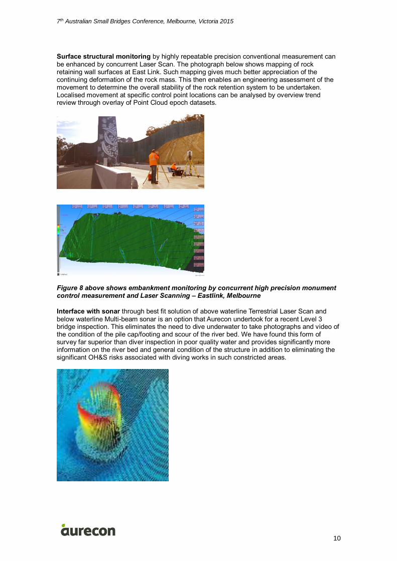
Finite analysis of structure deformation through input of Point Cloud mapping solutions to and use of software such as 3D-Reshaper. The point cloud survey results shown below is the deformation of a girder at Lucinda Wharf as a result of cyclone Yasi. Such surveys could also be used on road bridge girders that are subject to accidental collision.
Figure 7 above shows Point Cloud analysis of beam deformation at Lucinda Wharf
7th Australian Small Bridges Conference, Melbourne, Victoria 2015
10
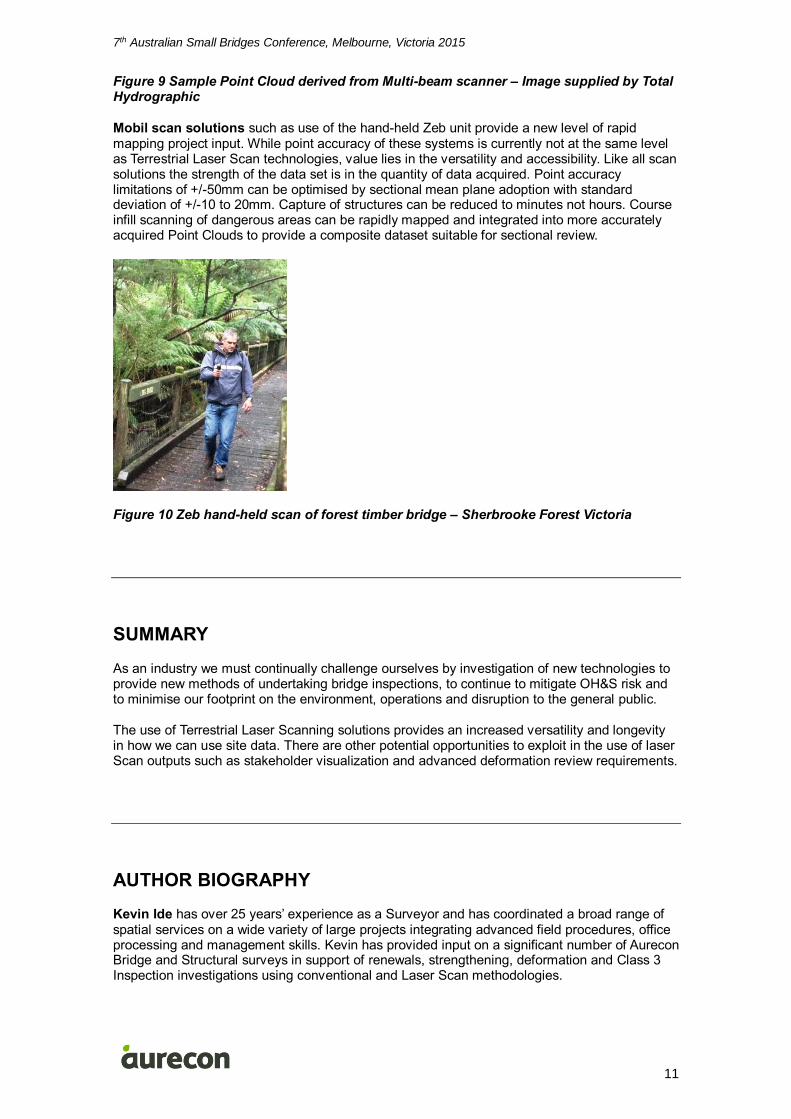
Surface structural monitoring by highly repeatable precision conventional measurement can be enhanced by concurrent Laser Scan. The photograph below shows mapping of rock retaining wall surfaces at East Link. Such mapping gives much better appreciation of the continuing deformation of the rock mass. This then enables an engineering assessment of the movement to determine the overall stability of the rock retention system to be undertaken. Localised movement at specific control point locations can be analysed by overview trend review through overlay of Point Cloud epoch datasets.
Figure 8 above shows embankment monitoring by concurrent high precision monument control measurement and Laser Scanning – Eastlink, Melbourne
Interface with sonar through best fit solution of above waterline Terrestrial Laser Scan and below waterline Multi-beam sonar is an option that Aurecon undertook for a recent Level 3 bridge inspection. This eliminates the need to dive underwater to take photographs and video of the condition of the pile cap/footing and scour of the river bed. We have found this form of survey far superior than diver inspection in poor quality water and provides significantly more information on the river bed and general condition of the structure in addition to eliminating the significant OH&S risks associated with diving works in such constricted areas.
7th Australian Small Bridges Conference, Melbourne, Victoria 2015
11
Figure 9 Sample Point Cloud derived from Multi-beam scanner – Image supplied by Total Hydrographic
Mobil scan solutions such as use of the hand-held Zeb unit provide a new level of rapid mapping project input. While point accuracy of these systems is currently not at the same level as Terrestrial Laser Scan technologies, value lies in the versatility and accessibility. Like all scan solutions the strength of the data set is in the quantity of data acquired. Point accuracy limitations of +/-50mm can be optimised by sectional mean plane adoption with standard deviation of +/-10 to 20mm. Capture of structures can be reduced to minutes not hours. Course infill scanning of dangerous areas can be rapidly mapped and integrated into more accurately acquired Point Clouds to provide a composite dataset suitable for sectional review.
Figure 10 Zeb hand-held scan of forest timber bridge – Sherbrooke Forest Victoria
SUMMARY
As an industry we must continually challenge ourselves by investigation of new technologies to provide new methods of undertaking bridge inspections, to continue to mitigate OH&S risk and to minimise our footprint on the environment, operations and disruption to the general public.
The use of Terrestrial Laser Scanning solutions provides an increased versatility and longevity in how we can use site data. There are other potential opportunities to exploit in the use of laser Scan outputs such as stakeholder visualization and advanced deformation review requirements.
AUTHOR BIOGRAPHY
Kevin Ide has over 25 years’ experience as a Surveyor and has coordinated a broad range of spatial services on a wide variety of large projects integrating advanced field procedures, office processing and management skills. Kevin has provided input on a significant number of Aurecon Bridge and Structural surveys in support of renewals, strengthening, deformation and Class 3 Inspection investigations using conventional and Laser Scan methodologies.

7th Australian Small Bridges Conference, Melbourne, Victoria 2015
12
Azimah Arbi is a Bridge Engineer of the Transportation Group within Aurecon’s Melbourne office. Since commencing work in 2009, she has been mainly involved in structural designs of bridges, railway structures, road crash barriers, retaining walls, marine structures and foundations. She has been involved detailed design for Regional Rail Link Work Package E, Level 3 inspection and assessment Wallen Road and Chandler Highway bridges for VicRoads North West.
Copyright Licence Agreement
The Author allows Leading Infrastructure (Organiser) to publish the work/s submitted for the 7th Annual Small Bridges Conference, granting Leading Infrastructure (Organiser) the non-exclusive right to:
• publish the work in printed format • publish the work in electronic format • publish the work online. The Author retains the right to use their work, illustrations (line art, photographs, figures, plates) and research data in their own future works The Author warrants that they are entitled to deal with the Intellectual Property Rights in the works submitted, including clearing all third party intellectual property rights and obtaining formal permission from their respective institutions or employers before submission, where necessary.