automated terrestrial laser scanner measurements of small-scale
TRANSCRIPT

International Snow Science Workshop Grenoble – Chamonix Mont-Blanc - 2013
Automated Terrestrial Laser Scanner measurements of small-scale snow avalanches
Marc S. Adams1,*, Engelbert Gleirscher1, Thomas Gigele1, Reinhard Fromm1
1 Austrian Research Centre for Forests (BFW), Innsbruck, Austria
ABSTRACT: Remote sensing is a powerful and versatile tool for measuring the spatial and temporal distribution of snow. In this study, an Automated Terrestrial Laser Scanner (ATLS) was employed to scan a mountainside in the ski area Lech Zürs (Austria). During the winter 2012/13, the ATLS gath-ered data on the snow depth distribution at the test site twice a day. In order to reduce the risk of ava-lanches to skiers, seven avalanche towers were placed on this slope by the ski resort operating com-pany. A mitigation measure called Snowcatcher was constructed in the runout zone for research pur-poses. It was instrumented with several load-measuring devices, to record forces in the system during an avalanche event. These sensors are supplemented by a network camera, which recorded images of the test site every 15 min. The combination of this data allows: I) monitoring the spatial distribution and height change of the snowpack throughout the winter; II) estimating the volume of artificially re-leased and spontaneous avalanches; III) cross-referencing the estimated avalanche masses with the exerted forces on the Snowcatcher, when impacted by an avalanche. The potential of these combined measurements is presented in two showcases: I) snow depth change within a 37 h period, where an avalanche was artificially released and impacted the Snowcatcher; II) recording the volume of multiple spontaneous avalanche events, which occurred on 4 June 2013. It is shown, that the ATLS setup pro-vides a very valuable data source for a wide range of applications in snow science and practice. KEYWORDS: Automated terrestrial laser scanning, Snowcatcher, avalanche control
1 INTRODUCTION
Collecting accurate data on the spatial and temporal distribution of snow in mountainous areas is essential to answering a wide range of questions from both science and practice. While in situ measurements of the snowpack may be expensive and potentially hazardous, remote sensing allows gathering data on the physical properties of snow, covering large areas from a safe distance (Nolin, 2010). Therefore, a wide range of remote sensing techniques have been applied to the fields of snow science and practice (Hall and Martinek, 1985). These techniques are particularly valu-able to avalanche hazard research and man-agement, as they for example provide area-wide data on the snow depth distribution in an avalanche path before and after an event (Schaffhauser et al., 2008). Avalanche hazard management also plays a major role in ski re-sorts, as many are endangered by avalanches,
which are often triggered artificially to reduce the risk to skiers.
In the scope of this work, an Automated Terrestrial Laser Scanner (ATLS) was em-ployed to continuously monitor a highly fre-quented mountainside in the ski area Lech Zürs (Austria), which has the potential for mul-tiple small avalanches. This methodology and instrument setup allowed recording the target area with a high temporal resolution, thus be-ing able to track the spatial snow depth distri-bution in the target area throughout the winter 2012/13.
Since the advent of the use of Terrestrial Laser Scanners (TLS) in snow science in 1999 (Moser et al., 2001), both the technical devel-opment of the hardware and software, as well as the amount of research and applications, have seen a staggering increase (Wiatr et al., 2013). This notwithstanding, so far few appli-cations have been published, which employ ATLS-based monitoring stations: Paar and Bauer (2001, 2004) have presented a similar application of TLS in the Arlberg region; Eitel et al. (2013) studied the potential of a low-cost ATLS system for monitoring and quantifying ecosystem structural dynamics.
The aim of this paper is to present and evaluate the benefits and possible constrains of the ATLS setup, while highlighting its poten-tial applications in combination with the other infrastructure available at the test site (i.e. Snowcatcher, avalanches masts, etc.).
______________________
*Corresponding author address: Marc S. Adams, Federal Research and Training Centre for For-ests, Natural Hazards and Landscape – BFW, Department of Natural Hazards, Rennweg 1, A-6020 Innsbruck, Austria; tel: +43-512 573933 5177; email: [email protected]
1060
International Snow Science Workshop Grenoble – Chamonix Mont-Blanc - 2013
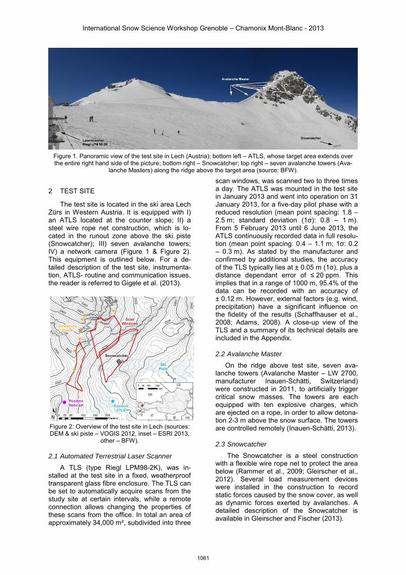
Figure 1. Panoramic view of the test site in Lech (Austria); bottom left – ATLS, whose target area extends over the entire right hand side of the picture; bottom right – Snowcatcher; top right – seven avalanche towers (Ava-
lanche Masters) along the ridge above the target area (source: BFW).
2 TEST SITE
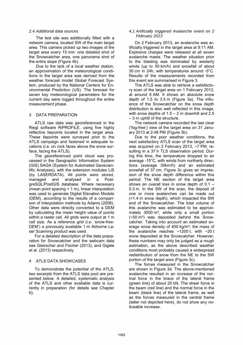
The test site is located in the ski area Lech Zürs in Western Austria. It is equipped with I) an ATLS located at the counter slope; II) a steel wire rope net construction, which is lo-cated in the runout zone above the ski piste (Snowcatcher); III) seven avalanche towers; IV) a network camera (Figure 1 & Figure 2). This equipment is outlined below. For a de-tailed description of the test site, instrumenta-tion, ATLS- routine and communication issues, the reader is referred to Gigele et al. (2013).
Figure 2: Overview of the test site in Lech (sources: DEM & ski piste – VOGIS 2012, inset – ESRI 2013,
other – BFW).
2.1 Automated Terrestrial Laser Scanner
A TLS (type Riegl LPM98-2K), was in-stalled at the test site in a fixed, weatherproof transparent glass fibre enclosure. The TLS can be set to automatically acquire scans from the study site at certain intervals, while a remote connection allows changing the properties of these scans from the office. In total an area of approximately 34,000 m², subdivided into three
scan windows, was scanned two to three times a day. The ATLS was mounted in the test site in January 2013 and went into operation on 31 January 2013, for a five-day pilot phase with a reduced resolution (mean point spacing: 1.8 – 2.5 m; standard deviation (1σ): 0.8 – 1 m). From 5 February 2013 until 6 June 2013, the ATLS continuously recorded data in full resolu-tion (mean point spacing: 0.4 – 1.1 m; 1σ: 0.2 – 0.3 m). As stated by the manufacturer and confirmed by additional studies, the accuracy of the TLS typically lies at ± 0.05 m (1σ), plus a distance dependant error of ≤ 20 ppm. This implies that in a range of 1000 m, 95.4% of the data can be recorded with an accuracy of ± 0.12 m. However, external factors (e.g. wind, precipitation) have a significant influence on the fidelity of the results (Schaffhauser et al., 2008; Adams, 2008). A close-up view of the TLS and a summary of its technical details are included in the Appendix.
2.2 Avalanche Master
On the ridge above test site, seven ava-lanche towers (Avalanche Master – LW 2700, manufacturer Inauen-Schätti, Switzerland) were constructed in 2011, to artificially trigger critical snow masses. The towers are each equipped with ten explosive charges, which are ejected on a rope, in order to allow detona-tion 2-3 m above the snow surface. The towers are controlled remotely (Inauen-Schätti, 2013).
2.3 Snowcatcher
The Snowcatcher is a steel construction with a flexible wire rope net to protect the area below (Rammer et al., 2009; Gleirscher et al., 2012). Several load measurement devices were installed in the construction to record static forces caused by the snow cover, as well as dynamic forces exerted by avalanches. A detailed description of the Snowcatcher is available in Gleirscher and Fischer (2013).
1061
2.4 Additional data sources
The test site was additionally fitted with a network camera, located SW of the main target area. This camera picked up two images of the target area every 15 min: one detailed shot of the Snowcatcher area, one panorama shot of the entire slope (Figure 4b).
Due to the lack of a local weather station, an approximation of the meteorological condi-tions in the target area was derived from the weather forecast model Global Forecast Sys-tem, produced by the National Centers for En-vironmental Prediction (US). The forecast for seven key meteorological parameters for the current day were logged throughout the entire measurement phase.
3 DATA PREPARATION
ATLS raw data was georeferenced in the Riegl software RiPROFILE, using five highly reflective tiepoints located in the target area. These tiepoints were surveyed prior to the ATLS campaign and fastened in adequate lo-cations (i.e. on rock faces above the snow sur-face, facing the ATLS).
The georeferenced point cloud was pro-cessed in the Geographic Information System (GIS) SAGA (System for Automated Geoscien-tific Analyses), with the extension modules LiS (by LASERDATA). All points were stored, managed and analysed in a Post-greSQL/PostGIS database. Where necessary (mean point spacing < 1 m), linear interpolation was used to generate Digital Elevation Models (DEM), according to the results of a compari-son of interpolation methods by Adams (2008). Other data were directly converted to a DEM by calculating the mean height value of points within a raster cell. All grids were output at 1 m cell size. As a reference grid (i.e. ‘snow-free-DEM’) a previously available 1 m Airborne La-ser Scanning product was used.
For a detailed description of the data prepa-ration for Snowcatcher and the webcam data see Gleirscher and Fischer (2013), and Gigele et al. (2013) respectively.
4 ATLS DATA SHOWCASES
To demonstrate the potential of the ATLS, two excerpts from the ATLS data pool are pre-sented below. A detailed, systematic analysis of the ATLS and other available data is cur-rently in preparation (for details see Chapter 6).
4.1 Artificially triggered Avalanche event on 2 February 2013
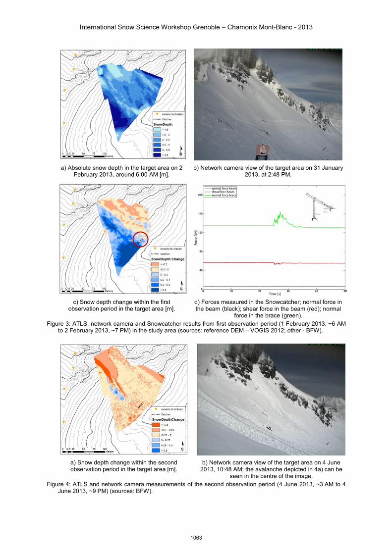
On 2 February 2013, an avalanche was ar-tificially triggered in the target area at 9:11 AM. Explosive charges were released at all seven avalanche masts. The weather situation prior to the blasting was dominated by westerly winds (up to 50 km/h) and snowfall of about 30 cm in 24h, with temperatures around -5°C. Results of the measurements recorded from this event are summarised in Figure 3.
The ATLS was able to retrieve a satisfacto-ry scan of the target area on 1 February 2013, at around 6 AM. It shows an absolute snow depth of 1.5 to 3.5 m (Figure 3a). The influ-ence of the Snowcatcher on the snow depth distribution is also well reflected in this image, with snow depths of 1.5 – 2 m downhill and 2.5 – 3 m uphill of the structure.
The network camera recorded the last clear (‘fog-free’) view of the target area on 31 Janu-ary 2013 at 2:48 PM (Figure 3b).
Due to the poor weather conditions, the next satisfactory ATLS scan of the target area was acquired on 2 February 2013, ~7 PM, re-sulting in a 37 h TLS observation period. Dur-ing this time, the temperature dropped to an average -15°C, with winds from northerly direc-tions (average 30km/h) and an estimated snowfall of 37 cm. Figure 3c gives an impres-sion of the snow depth difference within this period: The NE section of the target area shows an overall loss in snow depth of 0.1 – 0.3 m. In the SW of the scan, the deposit of one or more avalanches can be made out (<1.4 m snow depth), which impacted the SW end of the Snowcatcher. The total volume of this avalanche was estimated to be approxi-mately 3000 m³, while only a small portion (~50 m³) was deposited behind the Snow-catcher. Taking into account an estimated av-erage snow density of 400 kg/m³, the mass of the avalanche reaches ~1200 t, with ~20 t snow deposited at the Snowcatcher. However, these numbers may only be judged as a rough estimation, as the above described weather conditions most probably caused a widespread redistribution of snow from the NE to the SW portion of the target area (Figure 3c).
The forces measured in the Snowcatcher are shown in Figure 3d. The above-mentioned avalanche resulted in an increase of the nor-mal force in the brace of the lateral frame (green line) of about 25 kN. The shear force in the beam (red line) and the normal force in the beam (black line) of the lateral frame, as well as the forces measured in the central frame (latter not depicted here), do not show any no-ticeable increase.
1062
International Snow Science Workshop Grenoble – Chamonix Mont-Blanc - 2013
a) Absolute snow depth in the target area on 2 February 2013, around 6:00 AM [m].
b) Network camera view of the target area on 31 January 2013, at 2:48 PM.
c) Snow depth change within the first
observation period in the target area [m]. d) Forces measured in the Snowcatcher; normal force in the beam (black); shear force in the beam (red); normal
force in the brace (green). Figure 3: ATLS, network camera and Snowcatcher results from first observation period (1 February 2013, ~6 AM
to 2 February 2013, ~7 PM) in the study area (sources: reference DEM – VOGIS 2012; other - BFW).
a) Snow depth change within the second observation period in the target area [m].
b) Network camera view of the target area on 4 June 2013, 10:48 AM; the avalanche depicted in 4a) can be
seen in the centre of the image. Figure 4: ATLS and network camera measurements of the second observation period (4 June 2013, ~3 AM to 4
June 2013, ~9 PM) (sources: BFW).
1063

International Snow Science Workshop Grenoble – Chamonix Mont-Blanc - 2013
4.2 Multiple spontaneous avalanche events on 4 June 2013
On the morning of 4 June 2013 multiple smaller avalanches spontaneously released in the target area. After a prolonged snowfall peri-od at the end of Mai, both rising temperatures and strong solar radiation caused a weakening of the snow pack. A comparison of the ATLS measurements recorded in the morning and af-ternoon of that day (Figure 4a); show a general decrease of the snow depth, due to snow set-tling and ablation. Furthermore, one large and one smaller avalanche can be traced, both in the NW section of the target area. The recorded webcam data suggests, that the larger ava-lanche occurred between 8:33 AM and 8:48 AM and the smaller between 10:33 AM and 10:48 AM. Both the release area and the frac-ture depth (-1.5 – -1 m), as well as the height of the deposited snow mass (0.1 – 0.6 m) can be clearly identified in Figure 4a. The total volume of the larger avalanche in the SW was estimated to be approximately 100 m³.
Figure 4b gives an overview of the target ar-ea as recorded by the webcam, in the morning of 4 June 2013 at 10:48 AM.
5 CONCLUSION – LESSONS LEARNED
The two above presented showcases have effectively demonstrated the extensive potential of the ATLS setup. Despite partially unfavoura-ble weather conditions, several avalanche events could be detected by the ATLS and the corresponding release and deposition volume roughly estimated.
On the upside, the ATLS system allows closely monitoring the test site’s snow depth changes at a high temporal resolution, resulting in a wide range of applications, inter alia includ-ing the detection and mass balance estimation of avalanches. Once successfully setup, the ATLS only requires sporadic intervention and otherwise runs fully automatic, thus being very time- and cost-efficient. Due to the fact, that it is an active remote sensing system (i.e. emitting energy, rather than detecting natural radiation), the ATLS can perform measurements at any time of the day. Although the background radia-tion does have an influence on the fidelity of the ATLS results, it can operate under any lighting conditions, providing a clear line-of-sight to the target area is available. Finally, the integrated nature of the monitoring system at the test site in Lech (combination of ATLS, avalanche tow-ers, Snowcatcher and network camera) provided a unique opportunity and a wide range of poten-tial applications.
On the downside, the wavelength of the em-ployed TLS (905 nm), results in a high depend-ency of the system on favourable weather condi-tions. If no clear line-of-sight between the scan-ner and the target can be established (e.g. due to fog, precipitation or snowdrift), the resulting scans are mostly unusable. Unfortunately, these conditions sometimes prevail over several days in high-Alpine terrain and usually are most rele-vant to the formation and release of avalanches. Finally, as the TLS used in this study is a rela-tively old model (first introduced in 1999), the scan time is relatively long, increasing the sus-ceptibility to changing weather and limiting the size of the scanned area. The newer generation TLS (LPM-321, first introduced in 2007) was not available for the presented study.
6 OUTLOOK
As stated above, the data recorded with the ATLS opens up a wide range of different appli-cations. A detailed analysis of the presented data is currently under preparation including the following aspects: detailed analysis of the course of the late
winter / spring 2013 (Jan – Jun) combining results from all instruments in the test area
detailed analysis of the efficiency of artificial avalanche release in the test area
further comparison of the estimated deposi-tion volumes of recorded avalanche events and the forces measured in the Snowcatch-er These analyses are planned to be submitted
for publication in late 2013. A continuation of the ATLS measurements is planned for the coming winter 2013/14, possibly combining the ATLS with other instruments.
7 ACKNOWLEDGEMENTS
The authors would like to sincerely thank Skilifte Lech, in particular Mr Walter Metzler and Trumer Schutzbauten GmbH, in particular Mr Gernot Stelzer for their support.
Furthermore, the authors are much obliged to the GIS-service of the Province of Vorarlberg (VOGIS) for supplying essential GIS-data.
This work was partially carried out in the frame of the project SNOWCATCHER, which was supported by the FFG (Österreichische Forschungsförderungsgesellschaft; project number 815444).
The assistance of Armin Graf and the whole Snow and Avalanche Unit (BFW) is gratefully acknowledged.
1064
International Snow Science Workshop Grenoble – Chamonix Mont-Blanc - 2013
8 REFERENCES
Adams, M.S., 2008. Critical evaluation of terrestrial laser scanning in a snow-covered Alpine environment. Master thesis, Institute of Geography; University of Innsbruck, Austria.
Bauer, A. and Paar, G., 2004. Monitoring von Schneehöhen mittels terrestrischem Laserscanner zur Risikoanalyse von Lawinen. 14th International Course on Engineering Surveying, Zurich, Switzerland.
Eitel, J.U.H., Vierling, L.A. and Magney, T.S., 2013. A lightweight, low cost autonomously operating terrestrial laser scanner for quantifying and monitoring ecosystem structural dynamics. Agricultural and Forest Meteorology, 180, 86 – 96.
Gigele, T., Fromm, R. and Adams, M., 2013. Erfahrungsbericht ferngesteuerter Messungen mit terrestrischem Laserscanner. In proceedings ISSW – International Snow Science Workshop, Grenoble, France.
Gleirscher, E., and Fischer, J.-T., 2013. Retarding avalanches in motion with net structures. Cold Regions Science and Technology, in press.
Gleirscher, E., Fischer, J.-T., Rainer, E., Stelzer, G., Rammer, L., and Kern, M., 2012. Snowcatcher: A new snow avalanche protection measure. In proceedings ISSW – International Snow Science Workshop, Anchorage, Alaska.
Hall, D.K. and Martinec, J., 1985. Remote sensing of ice and snow. Chapham Hall Ldt., London.
Inauen-Schätti, 2013. Company website, http://www.seilbahnen.ch; accessed 14 August 2013.
Moser, A., Geigl, B., Steffan, H., Bauer, A., Paar, G., Fromm, R., Schaffhauser, H., Köck, K., Schönhuber, M. and Randeu, W. L., 2001. SAMPLE – Snow Avalanche Monitoring Prognosis by Laser Equipment – Entwicklung eines Meßsystems zur Bestimmung der zeitlichen und örtlichen Schneehöhe in Lawinenhängen als verbesserte Grundlage für die Lawinenprognose und ihre Anwendung am Präbichl. Final report.
Nolin, A.W., 2010. Recent advances in remote sensing of seasonal snow. Journal of Glaciology, 56, 200.
Paar, G. and Bauer, A., 2001. Terrestrial long range laser scanning for high density snow cover measurement. 5th Conference on Optical 3D Measurement Techniques, Vienna (Okt 01), ed. by V. Grün and Kahmen, pp. 33-40, Herbert Wichmann Verlag, Karlsruhe.
Rammer, L., Stelzer, G., and Kern, M., 2009. Investigation on the effectiveness of the catch-fence „Snowcatcher“ as avalanche protection system. In proceedings ISSW – International Snow Science Workshop, Davos, Switzerland.
Sailer, R., Fromm, R., Jörg, P., Schaffhauser, A. and Adams, M., 2008. Ground Based Remote Sensing of Snow Properties and Avalanche Simulation. Proceedings of Earth Conference 2008, Lesvos, Greece.
Schaffhauser, A., Adams, M., Fromm, R., Joerg, P., Luzi, G., Noferini, L. and Sailer, R., 2008. Remote sensing based retrieval of snow cover properties. Cold Regions Science and Technology 54: 164-175.
Wiatr, T., Reichertera, K., Papanikolaoub, I., Fernández-Steegerc, T. and Masona, J., 2013. Slip vector analysis with high resolution t-LiDAR scanning. Tectonophysics, in press.
9 APPENDIX
Figure 5: ATLS Riegl LPM98-2K at the test site. Table 1: Technical specifications of the Riegl LPM98-
2K.
1065