t13 - final report: terrestrial mollusk surveys for … report terrestrial mollusk surveys for...
TRANSCRIPT

Final Report
Terrestrial Mollusk Surveys for Survey and ManageSpecies in the Baker Lake Project Area
(Baker River Project Relicense Study No T13)
Prepared by:
Lia Kruger and Genevieve MartinHamer Environmental19997 Hwy 9Mount Vernon, WA 98274Phone: (360) 422-6510e-mail: [email protected]
Prepared for:
Baker River Project RelicenseWildlife and Terrestrial Resources Working Group
15 November 2002
Unpublished Work © 2002Puget Sound Energy, Inc.

EXECUTIVE SUMMARY
Puget Sound Energy (PSE) originally acquired their license for the Baker River Project
through the Federal Energy Regulatory Commission (FERC) on 4 June 1956 as Project
No. 2150; this license expires on 30 April 2006. To aid in the re-licensing process, the
Wildlife and Terrestrial Resources Working Group (WLTRWG) requested a survey for
“survey and manage” terrestrial mollusks adjacent to Baker Lake, which may be affected
by the Baker Lake Reservoir. These surveys were conducted in the fall of 2001 and
spring of 2002 using the Survey Protocol for Terrestrial Mollusk Species found the
Northwest Forest Plan, Version 2.0 (29 Oct 1997). Approximately 270 acres of potential
terrestrial mollusk habitat were within the sampling area delineated around the reservoir.
The first surveys began on 5 October 2001 and ended 16 November 2001. All fall and
spring surveys met the environmental constraints of the survey protocol.
During the 73 survey visits that covered approximately 270 acres, only 2 species of
survey and manage were suspected but not confirmed, Deroceras hesperium (evening
field slug) and Hemphillia glandulosa (warty jumping slug.) to be in the area. The most
common species found during the mollusk surveys were Haplotrema vancouverences,
Ariolimax columbianus,and Vespericola columbianus. H. vancouverences was found at
26 different locations throughout the project area. A. columbianus was found at 13
locations mostly in the southern part of the Baker River Project area and V. columbianus
at 10 locations throughout the perimeter of Baker Lake. Monadenia fidelis was
encountered at 4 locations, 1 east, 1 west, and 3 at the southern part of the lake.
Ancortrema sportella was located at 3 areas at the southern half of the. For the suspected

Terrestrial Mollusk Surveys in the Baker Lake Project Area; Final Report
November 20, 2002 2
survey and manage species encountered, Hemphilla glandulosa (unverified detection)
was identified in one location on the eastern lower portion of the lake and Deroceras
hesperium (unverified detection) was found on the western middle section of the Baker
Lake perimeter.
A variety of mollusk species were present in the Baker Lake survey area; however, only a
very small portion of these species were suspected to be survey and manage species as
defined by the Northwest Forest Plan. The habitat associated with the survey and
manage species in the area is abundant. Thus, we conclude that small-undetected
populations may exist. Why these suspected survey and manage species were scarce was
unknown. The low abundance and limited distribution in our study area could be the
result of species rarity and/or limited dispersal ability. Another possibility is that these
small populations could be isolated.

Terrestrial Mollusk Surveys in the Baker Lake Project Area; Final Report
November 20, 2002 3
INTRODUCTION ........................................................................................................................................ 4
RATIONAL AND SIGNIFICANCE OF THE STUDY............................................................................................ 5
STUDY AREA .............................................................................................................................................. 6
BACKGROUND........................................................................................................................................... 6
SURVEY AND MANAGE SPECIES LIKELY PRESENT IN THE PROJECT AREA............................................ 7SURVEY AND MANAGE SPECIES WITH LOWER LIKELIHOODS OF PRESENCE......................................... 8QUALIFICATIONS OF KEY PERSONNEL .................................................................................................. 10
METHODS ................................................................................................................................................. 10
DETERMINE THE SAMPLING AREA WITHIN THE PROJECT BOUNDARY ................................................ 10CONDUCTING TERRESTRIAL MOLLUSK SURVEYS................................................................................. 11
Timing of Surveys................................................................................................................................ 11Survey Method .................................................................................................................................... 12Data Recording................................................................................................................................... 13
RESULTS.................................................................................................................................................... 13
SURVEY CONDITIONS AND SPECIES FOUND ........................................................................................... 13ABUNDANCE AND DISTRIBUTION............................................................................................................ 14HABITAT ASSOCIATIONS ........................................................................................................................ 16
DISCUSSION.............................................................................................................................................. 18
ACKNOWLEDGMENTS.......................................................................................................................... 20
LITERATURE CITED.............................................................................................................................. 20
APPENDIX 1. ............................................................................................................................................ 35
Terrestrial Mollusk Surveys in the Baker Lake Project Area; Final Report
November 20, 2002 4
INTRODUCTION
The current license for the Baker River Watershed project will expire 30 April 2006. One
task to support the Baker River re-licensing project proposed by the Wildlife and
Terrestrial Resources Working Group (WLTRWG) was to conduct survey and manage
terrestrial mollusk surveys in the project area adjacent to Baker Lake reservoir. All
survey and manage terrestrial mollusks species meet table C-3 interagency standards
guidelines (ROD 1994) and should be protected if found. The protection is outlined in
Strategy 2 (as defined in the standards and guidelines) when these species occur naturally
within the range of the northern spotted owl. Before this effort, surveys for survey and
manage terrestrial mollusks had not been conducted in the Baker Lake watershed. We
lacked information on the species present, their habitat associations, their location
relative to the reservoir, and their abundance.
To answer these questions, this study conducted surveys for survey and manage
terrestrial mollusks as defined by the United States Forest Service (USFS) within 100 feet
of the high water mark of the reservoir to determine the presence or absence of these
species. Terrestrial mollusks that use logs or other accumulated debris as habitat within
this zone may die due to rising spring reservoir levels (Don Gay, personal
communication). The study was necessary to assess any impact on terrestrial mollusks
from management of the reservoir, and to assist the WLTRWG in developing protection,
mitigation, or enhancement measures to reduce these impacts. The objectives were to
determine the presence and distribution of survey and manage mollusk species within 100
Terrestrial Mollusk Surveys in the Baker Lake Project Area; Final Report
November 20, 2002 5
feet of the high water mark of Baker Lake reservoir and, if present, to identify associated
habitat types.
Rational and Significance of the Study
This study was designed to identify mollusk species present in the Baker River project
area. The results should assist the WLTRWG in assessing the impact reservoir
fluctuation may have on terrestrial mollusk species. Information generated from this
study, along with the vegetation cover class and habitat maps from proposed vegetation
studies (T2, T5 and T15), will assist in identifying areas of special concern (due to use by
survey and manage species), and help designate priority habitats within the project
boundaries.
The study should provide valuable information in the preparation of the final license
application and provide baseline species and habitat information necessary for
compliance with the Northwest Forest Plan.
These results constitute baseline information to evaluate project alternatives and/or
develop specific proposals for protection, mitigation, and enhancement of terrestrial
mollusk species populations and their habitats. In addition, this information will facilitate
the design and planning of future studies and inventories for the re-licensing project.

Terrestrial Mollusk Surveys in the Baker Lake Project Area; Final Report
November 20, 2002 6
STUDY AREA
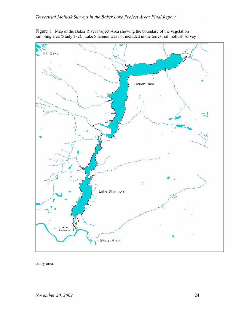
The Baker River watershed is located in a mountainous region on the west slope of the North
Cascades range in Skagit and Whatcom counties of Washington State (Figure 1). The headwaters
of the river lie in the northeastern section of the basin along the slopes of Mt. Challenger and
Whatcom Peak.
The Upper Baker Development completed in 1959 is located on Baker River
approximately 8 miles north of Concrete, Washington. Baker Lake, the reservoir behind
the Upper Baker dam, is approximately 9 miles long (Puget Sound Energy 2000) and is
surrounded by lands managed by the USFS. The study included areas within 100 feet of
the high water mark of the reservoir of Baker Lake. Figure 1 shows the project area for
Baker Lake including lands inside the FERC boundary that was the focus of sampling in
this study.
BACKGROUND
Nine survey and manage terrestrial species could occur in the Baker Lake Project area.
All species were noted when found. The snail Cryptomastix devia (Puget Oregonian)
was the only snail species reported in the Baker Lake project area (Funish et al. 1997).
Megomphix hemphilli (Oregon megomphix), Pristoloma articum crateris (Crater Lake
tightcoil), and Vertigo n.sp (Hoko vertigo) were suspected to be present (BLM 1999) and
the Bureau of Land Management (BLM) recommended surveys for these species. .
Survey and manage slug species include Deroceras hesperium (evening field slug),
Hemphillia burringtoni (keeled jumping slug), Hemphillia glandulosa (warty jumping
Terrestrial Mollusk Surveys in the Baker Lake Project Area; Final Report
November 20, 2002 7
slug), Hemphillia malonei (Malone jumping slug), and Hemphillia pantherina (panther
jumping slug). These mollusks were suspected to inhabit the project site. Therefore, the
United States Department of Agriculture (USDA) recommended surveys (Furnish 1997).
Non survey and manage mollusk species found in the project area were documented also.
A list of the survey and manage terrestrial mollusk species and description of their
habitats are shown in Table 1. Detailed habitat descriptions and geographic distributions
for each survey and manage terrestrial mollusk species supposed to be in the project area
and those species which could occur but are not likely to be present are described below.
Survey and Manage Species Likely Present in the Project Area
Cryptomastix devia (Puget Oregonian)
Cryptomastix devia has been found in the western Cascade Range and Puget Trough from
Southern Vancouver Island, B.C. through western Washington to the Oregon side of the
Columbia Gorge. C. Devia live in mature to late successional moist forest and riparian
zones, under logs, among leaf litter and/or talus. They are often found under or near big
leaf maple trees and may be underneath sword fern growing under these trees (BLM
1999).
Deroceras hesperium (evening field slug)
D. hesperium are found in low to mid-elevations between the western Cascade Range and
the Pacific Ocean from northwestern Oregon through western Washington, and on
Vancouver Island, B.C. D. hesperium are associated with litter, debris, rock crevices and
a variety of low vegetation. (BLM 1999).

Terrestrial Mollusk Surveys in the Baker Lake Project Area; Final Report
November 20, 2002 8
Hemphillia burringtoni (keeled jumping slug)
H. burringtoni are found throughout the Olympic Peninsula, WA. Their range extends
across the Puget Trough to the western Cascade Range in Washington and to the Coast
range of northwestern Oregon. This species prefers moist conifer forests and are
associated with conifer logs and/or heavy ground cover of low vegetation, litter, and
debris (BLM 1999).
Hemphillia glandulosa (warty jumping slug)
The range of the H. glandulosa extends from the western Cascade Range to the Pacific
coast from northern Oregon to British Columbia, Canada. They prefer moist coniferous
habitat and are associated with conifer logs and/or heavy ground cover of low vegetation,
litter, and debris (BLM 1999).
Survey and Manage Species with Lower Likelihood of Presence
Megomphix hemphilli (Oregon megomphix)
The range of Oregon megomphix is from the Puget Trough of western Washington
through the Willamette Valley, Cascade Range foothills, and Coast range of Oregon.
They inhabit moist coniferous and hardwood forests. Big leaf maples in the tree canopy
and sword ferns seem to be the characteristic habitat of this species (BLM 1999).

Terrestrial Mollusk Surveys in the Baker Lake Project Area; Final Report
November 20, 2002 9
Pristiloma articum crateris (Crater Lake tightcoil)
This species may be found south of Crater Lake, Klamath County, and Jefferson County
Oregon. It may also live in the Winema, Umpqua, and Willamette National Forests and
portions of BLM districts adjacent to these lands (BLM 1999).
Vertigo n.sp. (Hoko vertigo)
The Hoko vertigo is known only from the Hoko River drainage on the Olympic
Peninsula, Clallam County, Washington. This mollusk is associated with old growth
forests and riparian species. Smooth trunks and lower limbs of deciduous trees and shrubs
are typical habitats (BLM 1999).
Hemphillia malonei (Malone jumping slug)
H. malonei is endemic to the Mount Hood area and the Columbia Gorge in Oregon, and
Washington at elevations below 1,220 m (4,000 ft). The predominant habitat of this
species is mixed hardwood forests near the Columbia River (BLM 1999).
Hemphillia pantherina (panther jumping slug)
A single site near Lewis River in Skamania County, Washington is the only known
population of H. pantherina. However, it is suspected to live throughout the Cascade
Range of western Washington and from the Snoqualmie watershed to the Columbia
Gorge at elevations below 915 m (3,000 ft). The main habitat is deep forest litter near
streams (BLM 1999).

Terrestrial Mollusk Surveys in the Baker Lake Project Area; Final Report
November 20, 2002 10
Qualifications of Key Personnel
Hamer Environmental employed a team of skilled field biologists to conduct the
fieldwork for the project. All field members were certified by the USFS for terrestrial
mollusk surveys and had previous field experience conducting surveys for these species.
In addition, all team members were proficient with aerial photographs, topographic maps,
and global positioning systems (GPS) to locate survey sites in rugged terrain under many
environmental conditions.
METHODS
The research followed two basic steps:
(1) Determine the area to be sampled within the project boundary and;
(2) Sample within 100 feet of the high water mark of the reservoir using the
Survey Protocol for Terrestrial Mollusk Species from the Northwest Forest Plan,
Version 2.0 (29 Oct 1997).
Determine the Sampling Area within the Project Boundary
We obtained maps from R2 Resource Consultants Inc. for the survey and manage
terrestrial mollusk surveys. Joetta Zablotney from R2 Resource Consultants used
existing GIS data layers to produce a topographical map of the Baker Lake Reservoir and
FERC boundary. These maps included the Baker Lake Reservoir and all lands within
100 feet of the high water mark. The maps also displayed roads, trails, boat access
points, recreational sites, and other developed areas. The maps included a delineation

Terrestrial Mollusk Surveys in the Baker Lake Project Area; Final Report
November 20, 2002 11
line 100 feet from the high water mark (724-foot elevation) that was divided into 10-acre
sampling areas using GIS. These 10-acre sampling areas surround the reservoir. In
addition, UTM coordinates for the start and end points of each sequentially numbered 10-
acre sample plots were provided to field crews to assist them in locating the sample sites
using hand-held GPS units.
Conducting Terrestrial Mollusk Surveys
The objective of the terrestrial mollusk survey protocol was to establish whether a
specific survey and manage species was present in proposed project areas and to
document known sites discovered during surveys (Furnish et al. 1997). Approximately
270 acres of potential terrestrial mollusk habitat were surveyed within the sampling area
delineated around the reservoir by R2 Resource Consultants. The mollusk surveyors
located the beginning of each 10-acre survey area using hand-held GPS (Garmin e-trex
Summit) units. When biologists reached the sample unit, they surveyed the unit
according to the Survey Protocol for Terrestrial Mollusk Species from the Northwest
Forest Plan. The following description of the survey protocol was taken from Furnish et
al., 1997.
Timing of Surveys
Fall surveys can usually begin in mid-September to early October but yearly variations in
seasonal weather can justify an earlier or later survey season. Fall surveys began 1) after
autumn rains had soaked the ground (i.e., after 3 days of moderate rain); 2) when the
forest floor litter was wet through the soil between trees or; 3) after morning dew or frost

Terrestrial Mollusk Surveys in the Baker Lake Project Area; Final Report
November 20, 2002 12
was present when surveying in areas in which autumn rains did not occur before the
ground froze. Surveys could continue into the late fall or early winter until the air
temperature remained below 5°C (40°F) for more than 3 days, the ground remained
frozen, or snow cover prevented a reasonable search. Surveys resumed in the spring after
the snow melted and the ground had thoroughly thawed. Spring surveys could continue
as long as daytime air temperatures remained under 27°C (80°F).
Two visits were required to ensure that a range of environmental conditions was present
during the survey effort. Mollusk species are sensitive to changes in moisture,
temperature, and light; therefore, survey results can vary considerably from visit to visit.
For this study, the first surveys began on 5 October 2001 and ended 16 November 2001.
The second visit began 18 April 2002 and was completed on 30 April 2002
Survey Method
Surveyors meandered throughout each 10-acre sampling unit looking for any suitable
mollusk habitat (see Appendix 1 for habitat requirements) using the guidelines below.
1. Two 20-minute “sample areas” were identified for every 10 acres of suitable habitat
in the survey unit. For units less than 10 acres, at least 2 sample areas were
required.
2. For every 10 acres, opportunistic “point searches” were made of key habitat features
along the survey routes. These short searches were be done by rolling over small
logs, looking under bits of bark, rocks, vegetation and debris, picking through
hardwood litter, and searching the needle and leaf litter at the bases of logs and
Terrestrial Mollusk Surveys in the Baker Lake Project Area; Final Report
November 20, 2002 13
shrubs. Surveyors checked representative sample points where snails and slugs
might be expected be found. No single point was searched for more than 5
minutes (for a total of 20 minutes of point searches).
3. “Search areas” (20- minute search) were 5 meters in diameter.
4. A minimum of 1 hour of search time was completed per 10 acres that did not include
hiking, species identification, and flagging time.
5. “Search areas” were flagged only if a survey and manage species was found. A GPS
reading was taken of all search area locations.
6. A GPS reading of an opportunistic “point search” was only taken if a survey and
manage species was found. When a survey and manage species was detected, the
area was flagged.
Data Recording
The data recorded at all survey search areas and at the opportunistic search points where
a survey and manage species was found included air and soil temperature, elevation,
slope, aspect, special habitat features, plant association, overstory species, and understory
species (See Appendix 1 for data forms).
RESULTS
Survey Conditions and Species Found
For the surveys conducted during the fall, air and ground temperatures on each survey
day remained above 40°F thereby meeting the environmental constraints of the protocol
(Figure 6). For surveys conducted in the spring, air and ground temperatures never
Terrestrial Mollusk Surveys in the Baker Lake Project Area; Final Report
November 20, 2002 14
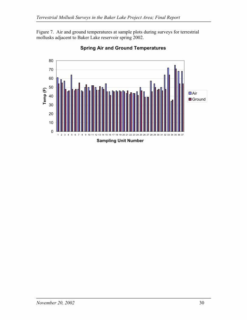
exceeded 80°F and were never below 40°F for 3 consecutive days (Figure 7). Surveys at
sampling units 27 and 34 were conducted with air and ground temperatures several
degrees below 40°F. However, sampling never occurred when 3 consecutive days of
lower temperatures existed. Therefore, all spring surveys met the environmental
constraints of the survey protocol.
Of the 9 survey and manage terrestrial mollusk species that could be present in the
sampling area, only 6 species had a high likelihood of presence. These species included
Cryptomastix devia (Puget Oregonian), Deroceras hesperium (evening field slug),
Hemphillia burringtoni (keeled jumping slug), and Hemphillia glandulosa (warty
jumping slug) (Table 1). During the 73 survey visits which covered approximately 270
acres, only two survey and manage species, Deroceras hesperium (evening field slug)
and Hemphillia glandulosa (warty jumping slug) may have been detected. An expert did
not confirm these, so they are only suspected to occur in the project area. All mollusk
species found during the survey period including non survey and manage species are
listed in Table 2.
Abundance and Distribution
The total numbers of live specimens encountered within the survey area for all plots and
visits combined are shown in Figure 2. Figure 3 shows the total number of live
specimens and remnant shells observed within the study area for all plots and visits
combined. . Mollusk remnant shells are the empty shells that do not have a snail inside.
Live specimens are those found alive. The most commonly encountered species was
Terrestrial Mollusk Surveys in the Baker Lake Project Area; Final Report
November 20, 2002 15
Haplotrema vancouverences with 60 detections, while the least commonly encountered
species with only one detection each were Ancotrema sportella, Deroceras hesperium
(unverified detection), and Hemphillia glandulosa (unverified detection). D. hesperium
and H. glandulosa (unverified detections) are survey and manage species.
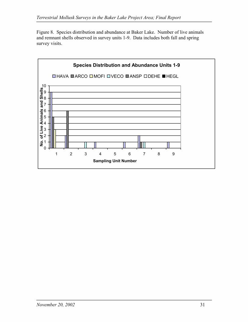
The locations of each transect and sample plot are shown in Figure 4. For spring and fall
survey visits, the distribution and abundance of all mollusk species found throughout the
study area are shown in Figures 8-11. Each graph represents a quarter of the total survey
area and gives species abundance for each sampling unit. The two suspected but
unverified) survey and manage species D. hesperium (evening field slug) and H.
glandulosa (warty jumping slug) were observed in units 12 and 34, respectively. The
units with the highest abundance of specimens were 1, 2, 26, and 31. Sampling sites with
no detections included units 5, 8, 13, 15, 16, and 23.
The most common species found during the mollusk surveys were Haplotrema
vancouverences, Ariolimax columbianus, and Vespericola columbianus. H.
vancouverences was found at 26 different locations throughout the project area. A.
columbianus was detected at 13 locations mostly in the southern part of the Baker River
Project area and V. columbianus at 10 locations throughout the perimeter of Baker Lake.
Monadenia fidelis was encountered at 4 locations, 1 east, 1 west, and 3 at the southern
part of the lake. Ancortrema sportella was located at 3 areas of the southern half of the
lake. For the suspected survey and manage but not verified species encountered,
Hemphillia glandulosa was in one location on the eastern lower portion of the lake and
Terrestrial Mollusk Surveys in the Baker Lake Project Area; Final Report
November 20, 2002 16
Deroceras hesperium (unverified detection) was on the western middle section of the
Baker Lake perimeter (Figure 5).
Habitat Associations
All surveys were conducted in suitable habitat for mollusk and slugs. All 74 survey plots
searched during this project were located in typical key habitats such as sword ferns, big
leaf maple litter and debris, as well as shrubs, logs and moist vegetation. Each survey and
manage mollusk species has a distinct habitat association. Key features within these
habitats may offer the ideal location for each particular species. Mollusk species
generally are distributed in moist, undisturbed coniferous forest plant associations while
others use specific habitat components such as rock outcrops, deciduous trees, or logs.
Survey and manage terrestrial mollusks are not riparian obligates; however, riparian
reserves may provide suitable habitat for many species. Some populations may be
strictly confined to the riparian zone in drier landscapes. Suitable habitats for each
survey and manage species including key habitat features are listed in Table 1.
The one specimen of H. glandulosa that may have been detected, but was not confirmed,
was discovered under sword fern in a mixed stand dominated by an overstory of western
red cedar, western hemlock, and big leaf maple. Canopy closure of the overstory was
35%. Sword fern and vine maple dominated the understory. Bryophytes dominated the
ground cover of the plot. The plot had a slope of 15% with a northeast aspect.

Terrestrial Mollusk Surveys in the Baker Lake Project Area; Final Report
November 20, 2002 17
The specimen of D. hesperium that may have been detected was found in an open area
devoid of any overstory. Therefore, canopy closure was 0%. Understory did not exist
while grass and soil dominated the ground cover. . The plot had a slope of 5% with a
north aspect.
To assess suitability of all habitats within the Baker Lake project area, we examined
vegetation cover types created for the Vegetation Mapping Project (T2) (Appendix 2).
This mapping project has identified all vegetation cover types around the perimeter of
Baker Lake. Specific polygons denote individual cover types. Each sampling unit created
for the mollusk project contained many of these polygons revealing the diversity of
vegetation per unit.
Suitable habitat for Cryptomastix devia, Megomphix hemphilli, and Vertigo n.sp. are
cover types such as mixed conifer/ deciduous forest that include: upland forests, middle-
late serial stage dominated by trees greater than 9” DBH and contain at least 20%
coniferous trees. Primary habitat for Hemphillia burringtoni, Hemphillia glandulosa,
Hemphillia malonei, Hemphillia pantherina, and Pristiloma articum crateris old-growth
conifer forest, mature conifer forest, and open mature conifer forest. Additional suitable
habitat may be found mid-successional conifer forest, open mid-successional conifer
forest, and pole conifer forest. Old growth conifer forests cover types include upland
forest, old forest serial stage, stand dominated by mature (>39” DBH) trees usually
greater than 250 years old, multistoried stands, abundant snag and coarse woody debris
material, and at least two tree species. Mature conifer forest cover types include upland

Terrestrial Mollusk Surveys in the Baker Lake Project Area; Final Report
November 20, 2002 18
forest, late serial stage, forested areas dominated by mature (> 21” DBH) trees, 80 to 250
years old, crown closure usually in excess of 60%, usually two storied to multi-storied
stands, medium to high density of snags and downed material and trees generally greater
than 100’. Open mature conifer forest cover types include upland forest, late serial stage,
forested areas dominated by mature (> 21” DBH) trees from 80 to 250 years old, crown
closure usually less than or equal to 60%, usually two storied stands, medium to high
density of snags and downed material, areas usually at higher elevations and/or with low
productivity. Suitable habitats for Deroceras hesperium are not as specific as for the
other survey and manage terrestrial mollusk species because little is known about this
species. D. hesperium may be found in most forested areas with low shrubs and rocks.
DISCUSSION
The survival of terrestrial mollusk species hinges upon the quality of their habitat.
According to the USFS protocol, both Hemphillia glandulosa and Deroceras hesperium
are vulnerable to heat and desiccation; therefore, they rely on logs and large woody
debris, forest floor litter, and spaces under or between rocks as refugia. These areas
maintain low temperatures and moderate humidity. Management considerations should
focus on maintaining the temperature and moisture of these microsites. Overstory and
understory vegetation need to be retained to shade the ground, and maintain humidity
through evapotranspiration and condensation of fog and dew. Recorded observations
(USFS, 1999) indicate western hemlock/Douglas fir stands should have summer crown
closure from 70-90%. Although we are still learning about the specific needs of mollusks,
it appears that a mix of conifers and hardwoods provides the best habitat. The diversity of
Terrestrial Mollusk Surveys in the Baker Lake Project Area; Final Report
November 20, 2002 19
plant species in the area should be optimized to provide a range of hosts for fungi and
other food substrates available throughout the season.
Management should also include maintenance and recruitment of large and small woody
debris and a thick layer of litter and duff on the forest floor. The components that are
mandatory aspects of the mollusks’ biology provide food, shelter from predators, and a
depository for their eggs (USFS, 1999). The logs provide travel corridors an important
consideration because mollusks have limited dispersal abilities and care should be taken
to avoid further isolation of individual populations. Therefore, habitat quality improves in
direct proportion to the amount of large woody debris.
The Northwest Forest Plan is designed to protect a variety of species associated with late
successional and old growth forests, including certain species of mollusks. Within the
survey area is a variety of different habitat types. Each survey and manage species listed
on Table 1 is associated with at least one of these habitat types. As a result, the perimeter
of Baker Lake could be considered good quality habitat although low in abundance for all
the survey and manage terrestrial mollusk species of the area. Surveys found an
abundance of terrestrial mollusk species. Although good habitat existed along the edge
of the reservoir, only a thin area along the edge of the forest was surveyed. However, in
this study, the number of detected survey and manage species was low.
H. vancouverences, A. columbianus, and V. columbianus are very common mollusk
species widely found throughout the survey area. These species will usually be abundant
Terrestrial Mollusk Surveys in the Baker Lake Project Area; Final Report
November 20, 2002 20
in all areas. For the survey and manage species, D. hesperium existed at only one
location on the west side of Baker Lake. H. glandulosa was encountered only on the east
side of the lake. We do not know why the quantity of survey and manage species was
small. The small amount and limited distribution in our study area could be due to the
species rarity and/or limited dispersal ability. In addition, these small populations could
be isolated and optimal habitat scarce. Nonetheless, we can assume that a small
population of these two species exists in the study area.
It is likely that a larger number of Survey and Manage species would have been found if
more area had been surveyed above the high water mark of the lake into the adjacent
forested areas. The habitat suitability improves and the amount of suitable habitat
increases further away from the lake and further from the surveyed area. Additional
surveys may be useful to generate more abundance and distribution information along
with the specific habitat associations for these two species.
ACKNOWLEDGMENTS
Numerous people were involved in this project. A special thanks to the great survey crew
(Frank Lapsansky, Natalie Martens, Annie Bourinsky, and Danielle Flath) for completing
the surveys to protocol, and to Joetta Zablotney of R2 Resource Consultants for creating
the maps for this project.
LITERATURE CITED
Bureau of Land Management. 1999. Field Guide to Survey and manage TerrestrialMollusk Species from the Northwest Forest Plan. BLM. Eugene, Oregon.
Terrestrial Mollusk Surveys in the Baker Lake Project Area; Final Report
November 20, 2002 21
Furnish. J., Monthy, R., and Applegarth, J. 1997. Survey protocol for terrestrial molluskspecies from the Northwest Forest Plan: Draft Version 2.0 (October 29, 1997). USDAForest Service/USDI Bureau of Land Management, Portland, OR.
Puget Sound Energy. http://www.pse.com/hydro/baker_river.html. April 2001.
Personal Communications
Gay, Don. Mt. Baker Snoqualmie National Forest. 2105 Highway 20, Sedro Woolley,WA
Walker and Associates, 12853 Interurban Avenue So, Seattle, WA.
Terrestrial Mollusk Surveys in the Baker Lake Project Area; Final Report
November 20, 2002 22
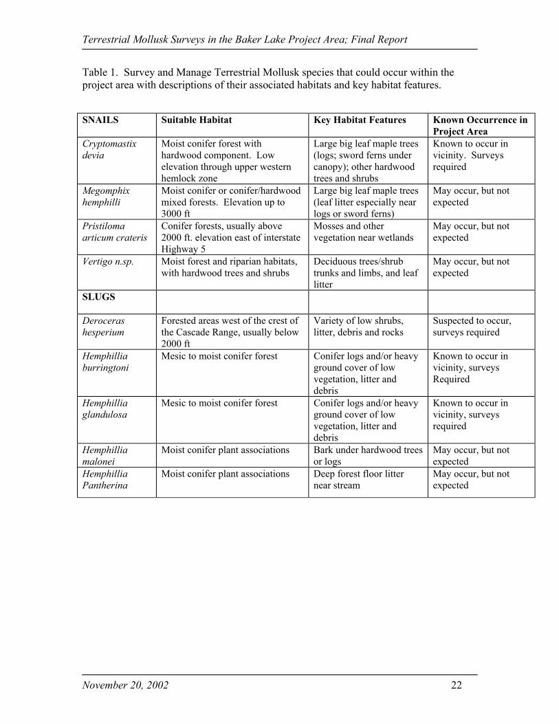
Table 1. Survey and Manage Terrestrial Mollusk species that could occur within theproject area with descriptions of their associated habitats and key habitat features.
SNAILS Suitable Habitat Key Habitat Features Known Occurrence inProject Area
Cryptomastixdevia
Moist conifer forest withhardwood component. Lowelevation through upper westernhemlock zone
Large big leaf maple trees(logs; sword ferns undercanopy); other hardwoodtrees and shrubs
Known to occur invicinity. Surveysrequired
Megomphixhemphilli
Moist conifer or conifer/hardwoodmixed forests. Elevation up to3000 ft
Large big leaf maple trees(leaf litter especially nearlogs or sword ferns)
May occur, but notexpected
Pristilomaarticum crateris
Conifer forests, usually above2000 ft. elevation east of interstateHighway 5
Mosses and othervegetation near wetlands
May occur, but notexpected
Vertigo n.sp. Moist forest and riparian habitats,with hardwood trees and shrubs
Deciduous trees/shrubtrunks and limbs, and leaflitter
May occur, but notexpected
SLUGS
Derocerashesperium
Forested areas west of the crest ofthe Cascade Range, usually below2000 ft
Variety of low shrubs,litter, debris and rocks
Suspected to occur,surveys required
Hemphilliaburringtoni
Mesic to moist conifer forest Conifer logs and/or heavyground cover of lowvegetation, litter anddebris
Known to occur invicinity, surveysRequired
Hemphilliaglandulosa
Mesic to moist conifer forest Conifer logs and/or heavyground cover of lowvegetation, litter anddebris
Known to occur invicinity, surveysrequired
Hemphilliamalonei
Moist conifer plant associations Bark under hardwood treesor logs
May occur, but notexpected
HemphilliaPantherina
Moist conifer plant associations Deep forest floor litternear stream
May occur, but notexpected

Terrestrial Mollusk Surveys in the Baker Lake Project Area; Final Report
November 20, 2002 23
Table 2. Species encountered during 2 survey visits to the Baker Lake Reservoir in fall2001 and spring 2002.
Scientific (Latin) Name Abbreviated Name Common Name
Ariolimax columbianus ARCO Banana slug
Deroceras hesperium* DEHE Evening field slug
Haplotrema vancouverences HAVA Robust lancetooth
Monadenia fidelis MOFI Pacific sideband
Vespericola columbianus VECO Northwest hesperian
Hemphillia glandulosa* HEGL Warty jumping slug
Ancotrema sportella ANSP Beaded lancetooth
*Survey and manage species, unverified detections
Terrestrial Mollusk Surveys in the Baker Lake Project Area; Final Report
November 20, 2002 24
Figure 1. Map of the Baker River Project Area showing the boundary of the vegetationsampling area (Study T-2). Lake Shannon was not included in the terrestrial mollusk survey
study area.

Terrestrial Mollusk Surveys in the Baker Lake Project Area; Final Report
November 20, 2002 25
Figure 2. Total of live terrestrial mollusk specimens encountered at all plots during 2survey visits adjacent to the Baker Lake reservoir, fall 2001 and spring 2002.
0
10
20
30
40
50
60
70
HAVA ARCO VECO M OFI ANSP DEHE HEGL CRDE HEBU HEM A HEPA M EHE PRAR PRCO PRDU VESP
Abbreviated Species Name
Tota
l Num
ber o
f Liv
e Sp
ecim
ens
* HEGL, DEHE- Unverified detection

Terrestrial Mollusk Surveys in the Baker Lake Project Area; Final Report
November 20, 2002 26
Figure 3. Total of live terrestrial mollusk specimens and remnant shells encountered atall plots during 2 survey visits adjacent to the Baker Lake reservoir fall 2001 and spring2002.
79
41
18
51 1 1 0 0 0 0 0 0 0 0 0
0
10
20
30
40
50
60
70
80
90
HAVA ARCO VECO M OFI ANSP DEHE HEGL CRDE HEBU HEM A HEPA M EHE PRAR PRCO PRDU VESP
Abbreviated Species Name
No. L
ive
Spe
cim
ens
and
Shel
ls
* DEHE and HEGL- Unverified detection
Terrestrial Mollusk Surveys in the Baker Lake Project Area; Final Report
November 20, 2002 27
Figure 4. Map of Baker Lake reservoir showing the location of sampling units andsurvey plot locations within these units.
(Placeholder sheet for Figure 4)

Terrestrial Mollusk Surveys in the Baker Lake Project Area; Final Report
November 20, 2002 28
Figure 5. Map of Baker Lake reservoir showing the locations of mollusk specimensobserved during the surveys.
(Placeholder sheet for Figure 5)

Terrestrial Mollusk Surveys in the Baker Lake Project Area; Final Report
November 20, 2002 29
Figure 6. Air and ground temperatures at sample plots during surveys for terrestrialmollusks adjacent to Baker Lake reservoir, fall 2001.
Fall Air and Ground Temperatures
0
10
20
30
40
50
60
70
80
1 2 3 4 5 6 7 8 9 10 11 12 13 14 15 16 17 18 19 2 21 2 2 2 25 2 27 2 2 3 31 3 3 3 35 3 37
Sampling Unit Number
Tem
p (F
)
AirGround
Terrestrial Mollusk Surveys in the Baker Lake Project Area; Final Report
November 20, 2002 30
Figure 7. Air and ground temperatures at sample plots during surveys for terrestrialmollusks adjacent to Baker Lake reservoir spring 2002.
Spring Air and Ground Temperatures
0
10
20
30
40
50
60
70
80
1 2 3 4 5 6 7 8 9 10 11 12 13 14 15 16 17 18 19 20 21 22 23 24 25 26 27 28 29 30 31 32 33 34 35 36 37
Sampling Unit Number
Tem
p (F
)
AirGround
Terrestrial Mollusk Surveys in the Baker Lake Project Area; Final Report
November 20, 2002 31
Figure 8. Species distribution and abundance at Baker Lake. Number of live animalsand remnant shells observed in survey units 1-9. Data includes both fall and springsurvey visits.
Species Distribution and Abundance Units 1-9
0123456789
10
1 2 3 4 5 6 7 8 9
Sampling Unit Number
No.
of L
ive
Ani
mal
s an
d Sh
ells
HAVA ARCO MOFI VECO ANSP DEHE HEGL

Terrestrial Mollusk Surveys in the Baker Lake Project Area; Final Report
November 20, 2002 32
Figure 9. Species distribution and abundance at Baker Lake. Number of live animalsand remnant shells observed in survey units 10-18. Data includes both fall and springsurvey visits.
Species Distribution and Abundance Units 10-18
0123456789
10
10 11 12 13 14 15 16 17 18
Sampling Unit Number
No.
of L
ive
Ani
mal
s an
d Sh
ells
HAVA ARCO MOFI VECO ANSP DEHE HEGL

Terrestrial Mollusk Surveys in the Baker Lake Project Area; Final Report
November 20, 2002 33
Figure 10. Species distribution and abundance at Baker Lake. Number of live animalsand remnant shells observed in survey units 19-27. Data includes both fall and springsurvey visits.
Species Distribution and Abundance Units 19-27
0123456789
10
19 20 21 22 23 24 25 26 27
Sampling Unit Number
No.
of L
ive
Ani
mal
s an
d Sh
ells
HAVA ARCO MOFI VECO ANSP DEHE HEGL

Terrestrial Mollusk Surveys in the Baker Lake Project Area; Final Report
November 20, 2002 34
Figure 11. Species distribution and abundance at Baker Lake. Number of live animalsand remnant shells observed in survey units 28-37. Data includes both fall and springsurvey visits.
Species Distribution and Abundance Units 28-37
0123456789
10
28 29 30 31 32 33 34 35 36 37
Sampling Unit Number
No.
of L
ive
Ani
mal
s an
d Sh
ells
HAVA ARCO MOFI VECO ANSP DEHE HEGL
Terrestrial Mollusk Surveys in the Baker Lake Project Area; Final Report
November 20, 2002 35
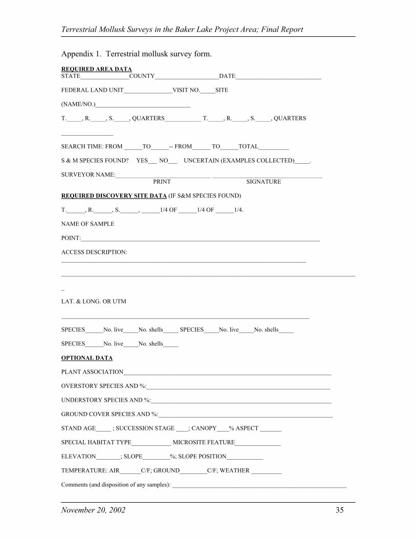
Appendix 1. Terrestrial mollusk survey form.
REQUIRED AREA DATASTATE________________COUNTY_____________________DATE____________________________
FEDERAL LAND UNIT________________VISIT NO._____SITE
(NAME/NO.)_______________________________
T._____, R._____, S._____, QUARTERS____________ T._____, R._____, S._____, QUARTERS
_________________
SEARCH TIME: FROM ______TO______-- FROM______ TO______TOTAL__________
S & M SPECIES FOUND? YES___ NO___ UNCERTAIN (EXAMPLES COLLECTED)_____.
SURVEYOR NAME:_______________________________ ____________________________________ PRINT SIGNATURE
REQUIRED DISCOVERY SITE DATA (IF S&M SPECIES FOUND)
T.______, R.______, S.______, ______1/4 OF ______1/4 OF ______1/4.
NAME OF SAMPLE
POINT:______________________________________________________________________________
ACCESS DESCRIPTION:________________________________________________________________________________
________________________________________________________________________________________________
_
LAT. & LONG. OR UTM
_________________________________________________________________________________
SPECIES______No. live_____No. shells_____ SPECIES_____No. live_____No. shells_____
SPECIES______No. live_____No. shells_____
OPTIONAL DATA
PLANT ASSOCIATION____________________________________________________________________
OVERSTORY SPECIES AND %:____________________________________________________________
UNDERSTORY SPECIES AND %:___________________________________________________________
GROUND COVER SPECIES AND %:_________________________________________________________
STAND AGE_____ ; SUCCESSION STAGE ____; CANOPY____% ASPECT _______
SPECIAL HABITAT TYPE_____________ MICROSITE FEATURE_______________
ELEVATION________; SLOPE_________%; SLOPE POSITION____________
TEMPERATURE: AIR_______C/F; GROUND_________C/F; WEATHER __________
Comments (and disposition of any samples): _________________________________________________________
Terrestrial Mollusk Surveys in the Baker Lake Project Area; Final Report
November 20, 2002 36
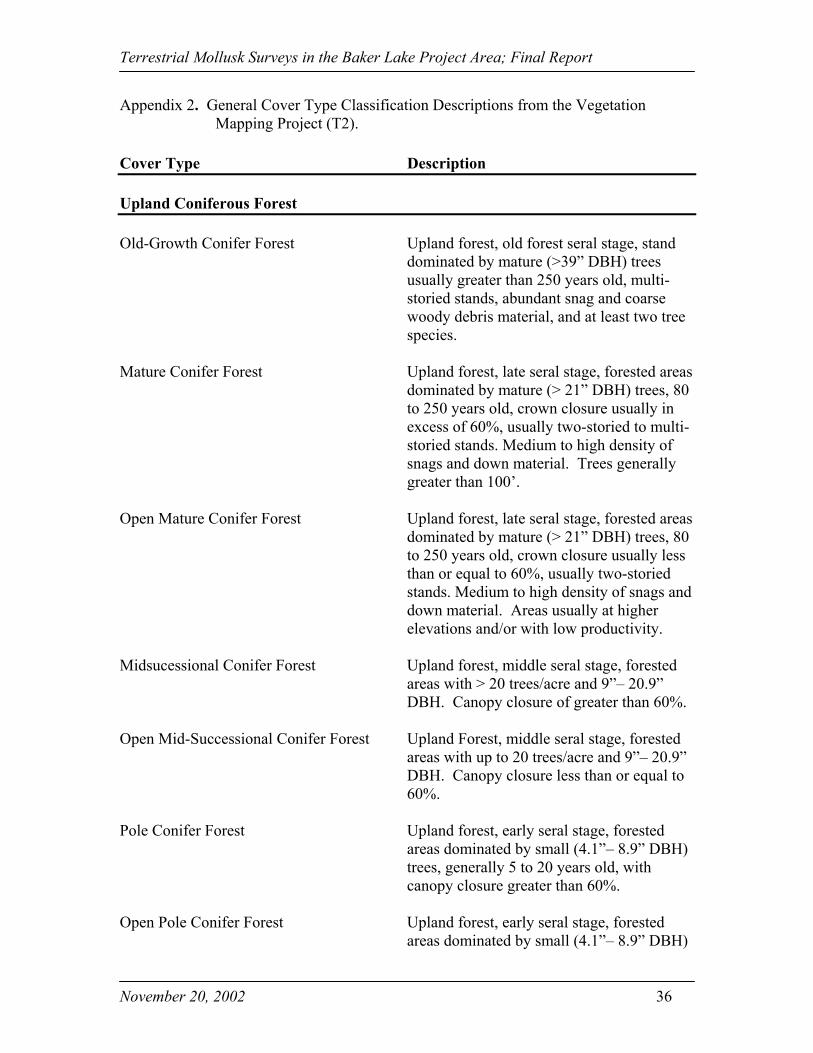
Appendix 2. General Cover Type Classification Descriptions from the VegetationMapping Project (T2).
Cover Type Description
Upland Coniferous Forest
Old-Growth Conifer Forest Upland forest, old forest seral stage, standdominated by mature (>39” DBH) treesusually greater than 250 years old, multi-storied stands, abundant snag and coarsewoody debris material, and at least two treespecies.
Mature Conifer Forest Upland forest, late seral stage, forested areasdominated by mature (> 21” DBH) trees, 80to 250 years old, crown closure usually inexcess of 60%, usually two-storied to multi-storied stands. Medium to high density ofsnags and down material. Trees generallygreater than 100’.
Open Mature Conifer Forest Upland forest, late seral stage, forested areasdominated by mature (> 21” DBH) trees, 80to 250 years old, crown closure usually lessthan or equal to 60%, usually two-storiedstands. Medium to high density of snags anddown material. Areas usually at higherelevations and/or with low productivity.
Midsucessional Conifer Forest Upland forest, middle seral stage, forestedareas with > 20 trees/acre and 9”– 20.9”DBH. Canopy closure of greater than 60%.
Open Mid-Successional Conifer Forest Upland Forest, middle seral stage, forestedareas with up to 20 trees/acre and 9”– 20.9”DBH. Canopy closure less than or equal to60%.
Pole Conifer Forest Upland forest, early seral stage, forestedareas dominated by small (4.1”– 8.9” DBH)trees, generally 5 to 20 years old, withcanopy closure greater than 60%.
Open Pole Conifer Forest Upland forest, early seral stage, forestedareas dominated by small (4.1”– 8.9” DBH)
Terrestrial Mollusk Surveys in the Baker Lake Project Area; Final Report
November 20, 2002 37
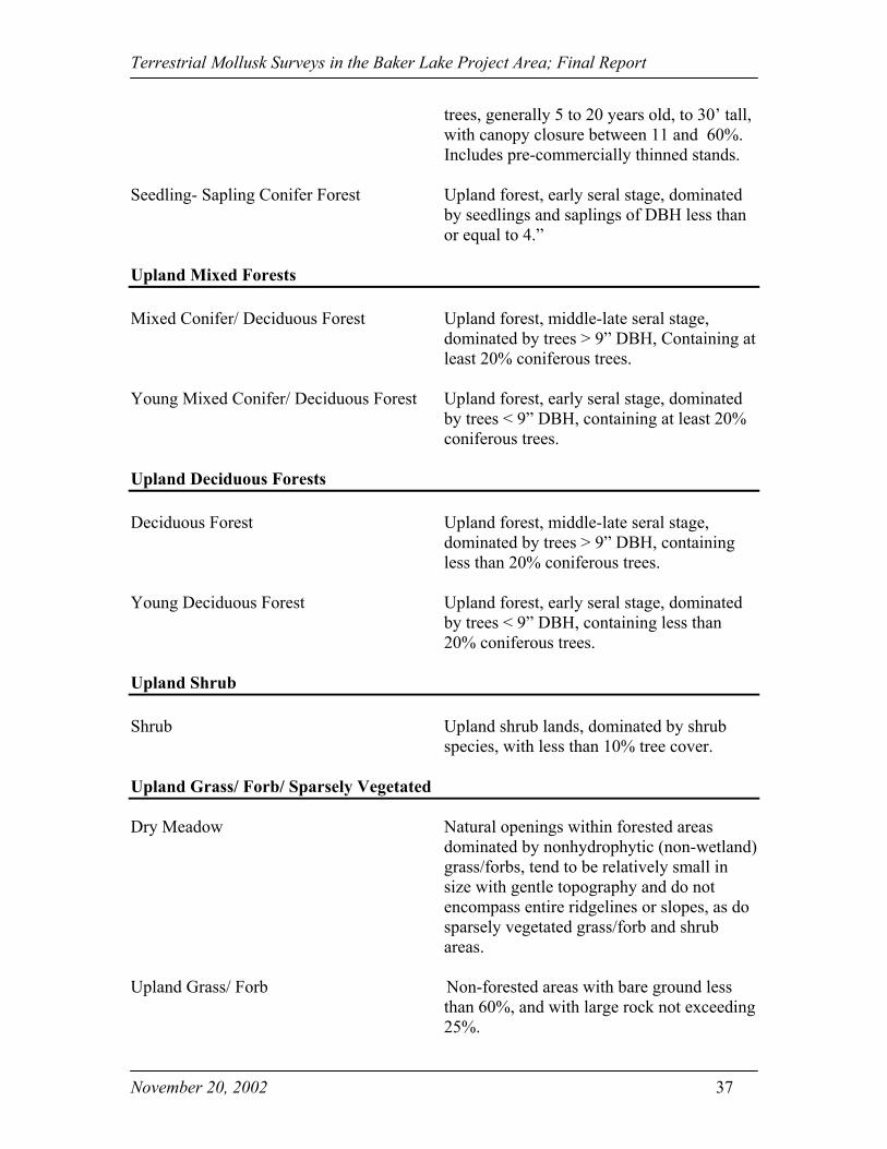
trees, generally 5 to 20 years old, to 30’ tall,with canopy closure between 11 and 60%.Includes pre-commercially thinned stands.
Seedling- Sapling Conifer Forest Upland forest, early seral stage, dominatedby seedlings and saplings of DBH less thanor equal to 4.”
Upland Mixed Forests
Mixed Conifer/ Deciduous Forest Upland forest, middle-late seral stage,dominated by trees > 9” DBH, Containing atleast 20% coniferous trees.
Young Mixed Conifer/ Deciduous Forest Upland forest, early seral stage, dominatedby trees < 9” DBH, containing at least 20%coniferous trees.
Upland Deciduous Forests
Deciduous Forest Upland forest, middle-late seral stage,dominated by trees > 9” DBH, containingless than 20% coniferous trees.
Young Deciduous Forest Upland forest, early seral stage, dominatedby trees < 9” DBH, containing less than20% coniferous trees.
Upland Shrub
Shrub Upland shrub lands, dominated by shrubspecies, with less than 10% tree cover.
Upland Grass/ Forb/ Sparsely Vegetated
Dry Meadow Natural openings within forested areasdominated by nonhydrophytic (non-wetland)grass/forbs, tend to be relatively small insize with gentle topography and do notencompass entire ridgelines or slopes, as dosparsely vegetated grass/forb and shrubareas.
Upland Grass/ Forb Non-forested areas with bare ground lessthan 60%, and with large rock not exceeding25%.

Terrestrial Mollusk Surveys in the Baker Lake Project Area; Final Report
November 20, 2002 38
Upland Sparsely Vegetated Grass/ Forb Non-forested areas with bare ground from60 – 90%, but with large rock not exceeding25%.
Wetlands (Shallow Water)
Palustrine Forested Wetland Non-tidal wetland characterized by woodyvegetation that is 6 m (20 ft) or taller(Cowardin et al., 1979).
Palustrine Scrub-Shrub Wetland Non-tidal wetland characterized by woodyvegetation that is up to 20 ft (6 m) tall. Thisincludes true shrubs, young trees, or treesand shrubs that are small or stunted becauseof environmental conditions (Cowardin etal., 1979).
Palustrine Emergent Wetland Non-tidal wetland characterized by erect,rooted herbaceous hydrophytes, excludingmosses and lichens. Areas that aredominated by pioneer plants which becomeestablished during periods of low water arenot Emergent Wetland and should beclassified as Vegetated Streambeds(Cowardin et al., 1979).
Aquatic Bed Wetlands dominated by plants that growprincipally on or below the surface of thewater for most of the growing season inmost years. The plants are either attached tothe substrate or float freely in the waterabove the bottom or on the surface(Cowardin et al., 1979).
Streambed All wetlands contained within the riverinesystem. The Riverine System includes allwetlands and deepwater habitats containedwithin a channel except for wetlanddominated by trees, shrubs, persistentemergents, emergent mosses or lichens.Vegetated streambeds are exposed longenough to be colonized by herbaceousannuals or seedlings herbaceous perennials.This vegetation, unlike Emergent Wetlands,

Terrestrial Mollusk Surveys in the Baker Lake Project Area; Final Report
November 20, 2002 39
is usually killed by rising water levels orsudden flooding (Cowardin et al., 1979).
Lacustrine Habitat Includes all wetlands and deepwater habitatswith all of the following characteristics: 1)situated in a topographic depression or adammed river channel; 2) lacking trees,shrubs, persistent emergents, emergentmosses or lichens with greater than 30%aerial coverage; and 3) total areas exceeds 8hectares (20 acres) (Cowardin et al., 1979).
Deepwater Habitat
Deepwater Habitat The boundary between wetland anddeepwater habitat in the Riverine andLacustrine system lies at a depth of 2 m (6.6ft) below low water (Cowardin et al., 1979).
Rock/ Talus/ Bare Soil/ Unconsolidated Substrates
Unconsolidated Shore Wetland habitats having the followingcharacteristics: 1) unconsolidated substrateswith less than 75% aerial cover of stone,boulders, or bedrock; 2) less than 30% aerialcover of vegetation other than pioneeringplants; and 3) any of the following waterregimes: irregularly exposed, regularlyflooded, irregularly flooded, intermittentlyflooded, saturated, or artificially flooded(Cowardin et al., 1979). Vegetatedunconsolidated nontidal shores are exposedfor sufficient periods to be colonized byherbaceous annuals or seedling herbaceousperennials.
Unconsolidated Bottom All wetland and deepwater habitats with atleast 25% cover of particles smaller thanstones and a vegetative cover less than 30%(Cowardin et al., 1979).
Rock/ Talus Homogeneous areas of rock rubble rangingin average size from 0.5 -6 ft (0.15 – 1.8 m)across, composed of basalt, sedimentary,

Terrestrial Mollusk Surveys in the Baker Lake Project Area; Final Report
November 20, 2002 40
and/or andesite; includes riprap slides. Maybe associated with cliffs.
Rock Outcropping Less than 25 ft in height (7.6 m). May beassociated with cliffs.
Cliff Near vertical wall of rock or a rock outcropat least 25 ft (7.6 m) high and occurringbelow 5,000 ft (1,524 m).
Unvegetated Area of bare ground with less than 10%vegetative cover.
Disturbed/ Modified Types
Agriculture/ Pasture
Residential/ Developed
Recreational Area
Project Facilities Dams, switchyards, etc.
Other Disturbed