wise eionet spatial data sets (internal version)
TRANSCRIPT

WISE EIONET spatial data sets (Internal Version)
Technical Report Version 1.4 2021-03-29
WISE EIONET spatial data sets V1.4 2021-03-29
i
Imprint
Title: WISE EIONET spatial data sets (Internal Version). Technical Report. Version 1.4. 2021-03-29 Creator: Fernanda Néry, European Environment Agency Created: 2018-09-20 Last update: 2021-03-29 Language: eng License: https://creativecommons.org/licenses/by/4.0/
Contents
Preamble ........................................................................................................................................................................................................................................ 1 Summary ........................................................................................................................................................................................................................................ 2 How to use the pre-filled data sets to prepare a WISE-5 delivery .............................................................................................................................................. 3
About the shapefiles ................................................................................................................................................................................................................. 3 About the identifiers ................................................................................................................................................................................................................. 3 Objects with status = 'retired' .................................................................................................................................................................................................. 4 Objects with status = 'superseded' .......................................................................................................................................................................................... 4 All other objects ........................................................................................................................................................................................................................ 5 Special cases .............................................................................................................................................................................................................................. 6
Annex 1. About the status value ................................................................................................................................................................................................... 7 Annex 2. Quick reference card...................................................................................................................................................................................................... 9
List of Figures Figure 3. Status. ............................................................................................................................................................................................................................. 7
List of Tables Table 1. Additional fields present in the shapefiles: cYear, country, lat, lon, statusCode, statusDate, remarks and qcCheck. .............................................. 3
WISE EIONET spatial data sets V1.4 2021-03-29
1
Preamble
The WISE databases contain near 70 000 identifiers related to EIONET monitoring sites, surface water bodies, groundwater bodies, sub-units or river basin districts. The country data sets can be downloaded from the WISE Restricted distribution area. Authorised reporters have access to this internal version to help prepared their WISE-5 delivery (the publicly available European dataset only includes non-confidential spatial objects with associated time series). The country data sets can also be accessed in CDR (see the Reportnet2 CDR Guidance). Around 39 000 EIONET identifiers have been replaced by new identifiers and are kept in the register for quality control purposes. Around 21 000 EIONET identifiers have been retired, because they are no longer in use. Note that the retired identifiers may have associated time series. Therefore, it is still possible to report a successor code to re-establish the continuity of the time series. Presently, around 10 000 EIONET identifiers are still in use. Countries that report under the Water Framework Directive should ideally report all their spatial data under that reporting obligation. The existing EIONET identifiers should be mapped to WFD identifiers. That requires a single delivery under WISE-5: the identifier of the corresponding WFD successor needs to be filled in. Please read the documentation available in http://cdr.eionet.europa.eu/help/WISE_SoE/wise5 Contact your EIONET National Focal Point if you need reporting permissions. Contact [email protected] if you need technical support preparing your data. Contact [email protected] if you have problems with your EIONET account.
WISE EIONET spatial data sets V1.4 2021-03-29
2
Summary
1. This document describes the content of the EIONET files in the WISE restricted distribution area:
River basin districts
River basin district sub-units
Surface water bodies
Groundwater bodies
Monitoring sites
2. The data sets include all information reported to the European Environment Agency (EEA) under the WISE - Spatial Data (WISE-5) reporting obligation, until 2021-03-01.
3. The data sets also include legacy information reported until 2013 to the EEA under the following terminated EIONET reporting obligations River quality (EWN-1), Lake quality (EWN-2), Groundwater quality (EWN-3), State & Quantity of Water Resources (EWN-4) and the previous data model of the WISE SoE - Emissions (WISE-1) reporting obligation.
4. The structure of the shapefiles follows the model defined for spatial data delivered under the WISE-5 reporting obligation. Detailed information about the structure and content of the spatial data is available in CDR help and specifically in the WISE GIS Guidance.
5. For the 27 EU Member States, Iceland, Norway and the United Kingdom that reported their River Basin Management Plans spatial data under the WFD2016 reporting obligation until 2021-03-01, the EIONET data was consolidated with the reported WFD spatial data (which is also available in the restricted area).
6. For 28 EU Member States that reported their River Basin Management Plans spatial data under the WFD2010 reporting obligation, the legacy EIONET data was also consolidated with the legacy WFD data (which is also available in the restricted area).
7. The geometry of all spatial objects is published in WGS 84 (urn:ogc:def:crs:EPSG::4326). The geometry of the objects was not edited or corrected: topological and positional errors may exist.
8. Due to incomplete information, the shapefiles may contain:
empty geometries
'NotApplicable' or 'Unknown' values in alphanumeric attributes
-9999 in numeric attributes
'9999-12-31' in attributes related to dates.
9. The shapefiles also contain attributes that provide ancillary information (see Table 1), but should be removed if the file is used to prepare a WISE-5 delivery.
10. Additional information is available in the WISE restricted distribution area, namely an extract the WFD2010 and WFD2016 data and the country boundaries.
WISE EIONET spatial data sets V1.4 2021-03-29
3
How to use the pre-filled data sets to prepare a WISE-5 delivery
About the shapefiles
1. The shapefiles have the structure required by the WISE-5 reporting.
2. After you update the information in each shapefile, use the conversion tool in the CDR envelope to upload and convert the zipfile to a GML file that can be delivered. Remember to remove the ancillary attributes (Table 1) before converting the shapefiles to GML. (Empty shapefile templates can also be found in the help page).
Table 1. Additional fields present in the shapefiles: cYear, country, lat, lon, statusCode, statusDate, remarks and qcCheck.
Field name Description
cYear Integer field containing the year when the information was reported. The value 2013 is used for the objects that have never been reported in WISE-5 (i.e. legacy EIONET data).
country Two-letter ISO code of the country (ISO 3166 alpha-2), except for Greece and the United Kingdom, for which the abbreviations EL and UK are used.
lat Latitude, in decimal degrees, of an arbitrary point located within the geometry of the object (if available)
lon Longitude, in decimal degrees, of an arbitrary point located within the geometry of the object (if available)
statusCode Status code of the thematic identifier in the WISE register (refer to Status for further information).
statusDate Date of reference for the status code (typically the date when the object was reported or extracted for publication).
remarks Additional information about the status code of the superseding object, if any.
qcCheck Additional information about checks performed in the data.
About the identifiers
1. The EEA uses the thematicId to identify each object uniquely across Europe and within each identifier scheme ('eionetMonitoringSiteCode', 'eionetSurfaceWaterBodyCode', 'eionetGroundWaterBodyCode', 'eionetSubUnitCode', 'eionetRBDCode'). Read the WISE GIS Guidance for further information.
2. The identifier of objects (thematicId) must follow the required syntax:
Start with the ISO 3166-1 alpha-2 country code, except for Greece ('EL') and the United Kingdom ('UK');
Be followed by the national code, with a maximum of 40 characters;
Use only uppercase letters [A to Z] and digits [0 to 9].
The underscore character ('_') or the hyphen character ('-') may be used as separators within the code (but not to separate the country code from the national code, and not in the end of the code).
3. The national code that was used when reporting the object is stored in the localId column. The EEA does not use the national codes, because they are not unique. You may use the localId value to cross-reference the WISE-5 record with information residing in the national databases. There are no syntax requirements for the national code: use whatever code is used in the national systems.
WISE EIONET spatial data sets V1.4 2021-03-29
4
Objects with status = 'retired'
1. Review all objects with status = 'retired'.
2. These objects are not used in EEA products, because they have no associated time series – or have been retired because they have not been used since 2013.
3. If you are not going to report time series associated with that object, you can simply delete that record (there is no need to report it back to EEA).
4. If you plan to deliver time series associated with that object (under WISE-1, WISE-3 or WISE-4), then it
must be included in your WISE-5 delivery.
Contact [email protected]
Important note: When reporting time series under WISE-1, WISE-3 or WISE-4, the EU-27 countries, Iceland, Norway and the United Kingdom should use WFD monitoring sites, water bodies, etc. The WFD objects are reported under the WFD2022 Spatial reporting obligation, and it is not necessary to report them once again in WISE-5. Use EIONET objects only if strictly necessary (e.g. multiple reservoirs that are part of the same WFD waterbody).
Objects with status = 'superseded'
1. Review all objects with status = 'superseded'. 2. For each of these objects, a replacement identifier is proposed in the successoId attribute. The successor
can be:
another EIONET object reported at a later date (succeIdSch LIKE 'eionet%')
a WFD object reported under the Water Framework Directive (succeIdSch LIKE 'eu%')
3. If the replacement is correct, you can simply delete that record (there is no need to report it again).
4. If the replacement is incorrect, then contact [email protected].
WISE EIONET spatial data sets V1.4 2021-03-29
5
All other objects
1. If an object has been replaced, please provide its successors (it may be another EIONET object or a WFD object). Use the successoId attribute and in the the succeIdSch attribute. Set wEvolution = 'deletion'.
2. You may use the process in point 1 to correct any errors – for example if there are any wrong identifiers in the shapefiles, simply provide their correct identifier as a successor.
3. If the object has been deleted (e.g. a monitoring site that was retired) and was not replaced, then set wEvolution = 'deletion'. Remember to provide any missing value, especially the geometry (see point 3 and 4 below).
4. Check the missing values, especially the geometry: please complete the information as much as possible prior to delivering the data.
5. If there are new objects to be reported, simply add the necessary records and fill the values according to
the instructions in the WISE GIS Guidance.
WISE EIONET spatial data sets V1.4 2021-03-29
6
Special cases
1. The data set may contain a shapefile named GroundWaterBodyPoint.shp – it contains information about groundwater bodies for which only the location of a point was known. Groundwater bodies must be reported as polygons: use the GroundWaterBody.shp for that effect. You cannot report point or line geometries for groundwater bodies. Note: If a spatial delineation of the groundwater body is not available, you may use a convex hull based on the location of national sites monitoring the water body. Most GIS software will allow the creation of convex hull geometries; see for example ArcGIS or QGIS. (EU-27 countries, Iceland, Norway and the United Kingdom should always use WFD groundwater bodies, which have already been reported.).
2. The data set may contain a shapefile named SurfaceWaterBodyPoint.shp – it contains information about surface water bodies for which only the location of a point was known. Surface water bodies must be reported as lines (use the SurfaceWaterBodyLine shapefile) or as polygons (use the SurfaceWaterBody shapefile). Note: If the geometry of surface water bodies is not available from a national data source, consider using a publicly available dataset such as Ecrins or EU-Hydro. Strictly speaking, only the surface water bodies with associated time series (and their monitoring sites) need to be reported.
3. If the delineation of the main river basin is not available, you may report the entire country as a single River Basin District and its single SubUnit. This may apply to the following cases:
Country Identifier IdentifierScheme Observations
AL AL100 eionetRBDCode Report the geometry.
AL200 eionetRBDCode Report the geometry.
AL300 eionetRBDCode Report the geometry.
AL400 eionetRBDCode Report the geometry.
AL500 eionetRBDCode Report the geometry.
AL600 eionetRBDCode Report the geometry.
AL800 eionetRBDCode Report the geometry.
BA No information available. If necessary report the country geometry as a single RBD (e.g. BA1)
ME No information available. If necessary report the country geometry as a single RBD (e.g. ME1)
MK No information available. If necessary report the country geometry as a single RBD (e.g. MK1)
RS RS1 eionetRBDCode Report the geometry.
TR No information available. If necessary report the country geometry as a single RBD (e.g. TR1)
XK No information available. If necessary report the country geometry as a single RBD (e.g. XK1)
WISE EIONET spatial data sets V1.4 2021-03-29
7
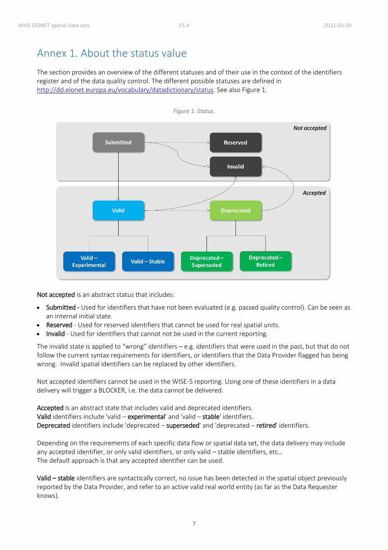
Annex 1. About the status value
The section provides an overview of the different statuses and of their use in the context of the identifiers register and of the data quality control. The different possible statuses are defined in http://dd.eionet.europa.eu/vocabulary/datadictionary/status. See also Figure 1.
Figure 1. Status.
Not accepted is an abstract status that includes:
Submitted - Used for identifiers that have not been evaluated (e.g. passed quality control). Can be seen as an internal initial state.
Reserved - Used for reserved identifiers that cannot be used for real spatial units. Invalid - Used for identifiers that cannot not be used in the current reporting.
The invalid state is applied to “wrong” identifiers – e.g. identifiers that were used in the past, but that do not follow the current syntax requirements for identifiers, or identifiers that the Data Provider flagged has being wrong. Invalid spatial identifiers can be replaced by other identifiers. Not accepted identifiers cannot be used in the WISE-5 reporting. Using one of these identifiers in a data delivery will trigger a BLOCKER, i.e. the data cannot be delivered. Accepted is an abstract state that includes valid and deprecated identifiers. Valid identifiers include 'valid – experimental' and 'valid – stable' identifiers. Deprecated identifiers include 'deprecated – superseded' and 'deprecated – retired' identifiers. Depending on the requirements of each specific data flow or spatial data set, the data delivery may include any accepted identifier, or only valid identifiers, or only valid – stable identifiers, etc… The default approach is that any accepted identifier can be used. Valid – stable identifiers are syntactically correct, no issue has been detected in the spatial object previously reported by the Data Provider, and refer to an active valid real world entity (as far as the Data Requester knows).

WISE EIONET spatial data sets V1.4 2021-03-29
8
Valid – experimental identifiers are syntactically correct identifiers that are proposed by the Data Requester (i.e. the EEA or DG ENV) to replace invalid identifiers. These identifiers were never reported by countries. They are proposed as a replacement for an invalid identifier that was reported by in the past (e.g. an identifier that had special characters). If countries accept the change and use it in the reporting, then the identifier state will be changed to 'valid – stable', 'deprecated – superseded' or 'deprecated – retired' (depending on what is reported, see definitions below). Valid identifiers are syntactically correct identifiers reported by the Data Provider. However issues have been detected with the spatial object itself (e.g. the name is missing and/or the geometry needs to be checked), so the identifier cannot be marked as 'valid – stable'. Valid identifiers may replace 'deprecated' identifiers or 'invalid' identifiers (the same applies to 'valid – stable' or valid – experimental identifiers). Deprecated – superseded identifiers are syntactically correct identifiers that have been replaced by another identifier (as reported by Data Providers in the normal reporting process, using the life-cycle information attributes). Deprecated – retired identifiers are syntactically correct identifiers that are no longer used and have not been replaced (e.g. a monitoring site that is no longer operational and has not been replaced by a different one). Deprecated identifiers are syntactically correct identifiers that were valid in the past. This status is only used when there is not enough information to know if the identifier has been superseded or retired.
WISE EIONET spatial data sets V1.4 2021-03-29
9
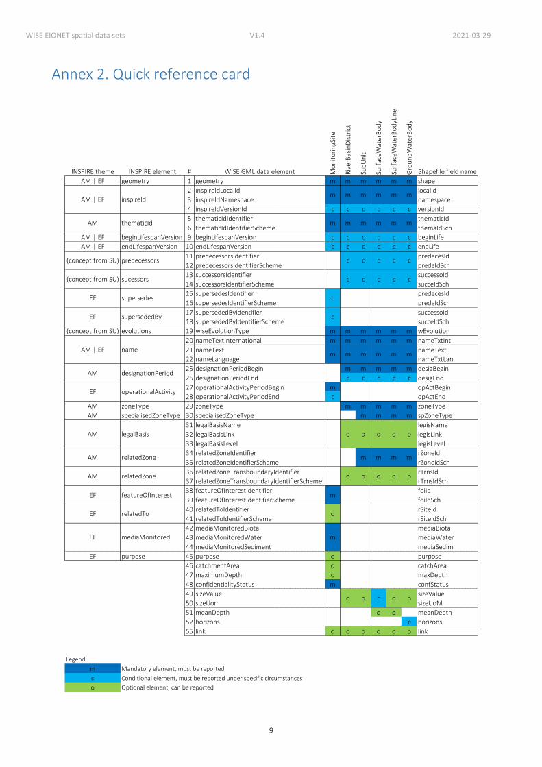
Annex 2. Quick reference card
INSPIRE theme INSPIRE element # WISE GML data element Mo
nit
ori
ngS
ite
Riv
erB
asin
Dis
tric
t
Sub
Un
it
Surf
aceW
ater
Bo
dy
Surf
aceW
ater
Bo
dyL
ine
Gro
un
dW
ater
Bo
dy
Shapefile field name
AM | EF geometry 1 geometry m m m m m m shape
2 inspireIdLocalId localId
3 inspireIdNamespace namespace
4 inspireIdVersionId c c c c c c versionId
5 thematicIdIdentifier thematicId
6 thematicIdIdentifierScheme themaIdSch
AM | EF beginLifespanVersion 9 beginLifespanVersion c c c c c c beginLife
AM | EF endLifespanVersion 10 endLifespanVersion c c c c c c endLife
11 predecessorsIdentifier predecesId
12 predecessorsIdentifierScheme predeIdSch
13 successorsIdentifier successoId
14 successorsIdentifierScheme succeIdSch
15 supersedesIdentifier predecesId
16 supersedesIdentifierScheme predeIdSch
17 supersededByIdentifier successoId
18 supersededByIdentifierScheme succeIdSch
(concept from SU) evolutions 19 wiseEvolutionType m m m m m m wEvolution
20 nameTextInternational m m m m m m nameTxtInt
21 nameText nameText
22 nameLanguage nameTxtLan
25 designationPeriodBegin m m m m m desigBegin
26 designationPeriodEnd c c c c c desigEnd
27 operationalActivityPeriodBegin m opActBegin
28 operationalActivityPeriodEnd c opActEnd
AM zoneType 29 zoneType m m m m m zoneType
AM specialisedZoneType 30 specialisedZoneType m m m m spZoneType
31 legalBasisName legisName
32 legalBasisLink legisLink
33 legalBasisLevel legisLevel
34 relatedZoneIdentifier rZoneId
35 relatedZoneIdentifierScheme rZoneIdSch
36 relatedZoneTransboundaryIdentifier rTrnsId
37 relatedZoneTransboundaryIdentifierScheme rTrnsIdSch
38 featureOfInterestIdentifier foiId
39 featureOfInterestIdentifierScheme foiIdSch
40 relatedToIdentifier rSiteId
41 relatedToIdentifierScheme rSiteIdSch
42 mediaMonitoredBiota mediaBiota
43 mediaMonitoredWater mediaWater
44 mediaMonitoredSediment mediaSedim
EF purpose 45 purpose o purpose
46 catchmentArea o catchArea
47 maximumDepth o maxDepth
48 confidentialityStatus m confStatus
49 sizeValue sizeValue
50 sizeUom sizeUoM
51 meanDepth o o meanDepth
52 horizons c horizons
55 link o o o o o o link
Legend:
m
c
o
Conditional element, must be reported under specific circumstances
Optional element, can be reported
o o c o o
Mandatory element, must be reported
EF featureOfInterest m
EF relatedTo o
EF mediaMonitored m
AM relatedZone o o o o o
AM relatedZone m m m m
AM designationPeriod
EF operationalActivity
AM legalBasis o o o o o
m m m m m
(concept from SU) sucessors c c c c
EF supersedes c
EF supersededBy c
AM | EF namem
c
(concept from SU) predecessors c c c c c
AM thematicId m m m m m m
AM | EF inspireIdm m m m m m