ontario ministry of the environment - record of site ... 214206.pdf · ontario ministry of the...
TRANSCRIPT

Ontario Ministry of the Environment - Record of Site Condition # 214206
Record of Site Condition
Under Part XV.1 of the Environment Protection Act
Summary
Notice to Readers Concerning Due Diligence
This record of site condition has been filed in the Environmental Site Registry to which the public has
access and which contains a notice advising users of the Environmental Site Registry who have dealings
with any property to consider conducting their own due diligence with respect to the environmental
condition of the property, in addition to reviewing information in the Environmental Site Registry.
Contents of this Record of Site Condition
This record of site condition consists (RSC) of this document which is available to be printed directly from
the Environmental Site Registry as well as all supporting documentation indicated in this RSC to have been
submitted in electronic format to the Ministry of the Environment.
Record of Site Condition Number 214206Date Filed to Environmental Site Registry 2014/07/29Certification Date 2014/01/28Current Property Use CommercialIntended Property Use ResidentialCertificate of Property Use Number No CPUApplicable Site Condition Standards** Full Depth Generic Site Conditions Standard,
with Non-potable Ground Water, CoarseTextured Soil, for Residential property use
Property Municipal Address 256 NIPISSING STREET, STURGEON FALLS,ON, P2B 3A2
1 of 20Filed Record of Site Condition # 214206 on 2014/07/29

PART 1: PROPERTY OWNERSHIP, PROPERTY INFORMATION AND OWNER'S CERTIFICATIONS
Information about the owner who is submitting or authorizing the submission of the RSC
Owner Name PIERRE SÉNÉCAL
Mailing Address 45 RIVERFRONT DRIVE, STURGEON FALLSONTARIO, CANADA
Postal Code P2B 3G1
Phone (705) 753-1484
Fax
Email Address
Information about other current owners
Owner Name STEPHANIE JOSETTE SÉNÉCAL
Mailing Address 45 RIVERFRONT DRIVE, STURGEON FALLSONTARIO, CANADA
Postal Code P2B 3G1
Phone (705) 753-1484
Fax
Email Address [email protected]
2 of 20Filed Record of Site Condition # 214206 on 2014/07/29

RSC Property Location Information
Municipal Address(es) 256 NIPISSING STREET, STURGEON FALLS, ON P2B 3A2
Municipality West Nipissing
Legal Description See Attached Lawyer’s Letter
Assessment Roll Number(s)
485201000507575
Property Identifier Number(s)
49080-0697 (LT)
RSC Property Geographical References
Coordinate System UTM
Datum NAD 83
Zone 17
Easting 582,749.76
Northing 5,135,162.60
RSC Property Use Information
The following types of property uses are defined by the Regulation: Agricultural or other use, Commercial use, Community use, Industrial use, Institutional use, Parkland use, and Residential use.
Current Property Use Commercial
Intended Property Use Residential
Certificate of Property Use has been issued under section 168.6 of the EPA
No
3 of 20Filed Record of Site Condition # 214206 on 2014/07/29

Please See the Signed Statements of Property Owner, or Agent, or Receiver at the End of this RSC
The rest of this page has been left intentionally blank
4 of 20Filed Record of Site Condition # 214206 on 2014/07/29

PART 2: LIST OF REPORTS, SUMMARY OF SITE CONDITIONS AND QUALIFIED PERSON’S STATEMENTS AND CERTIFICATIONSQualified Person's Information
Name JAKE BERGHAMER
Type of Licence Under Professional Engineers Act
Licence
Licence Number 90521410
QP Employer Name LVM|MERLEX LTD.
Mailing Address 2-120 PROGRESS COURT, NORTH BAYONTARIO, P1A 0C2 CANADA
Phone (705) 476-2550
Fax (705) 476-8882
Email Address [email protected]
Municipal Information
Local or Single-Tier Municipality
West Nipissing
Ministry of the Environment District Office
District Office Sudbury District Office
District Office Address Suite 1201, 199 Larch St., Sudbury ON P3E 5P9
5 of 20Filed Record of Site Condition # 214206 on 2014/07/29

Phase One Environmental Site Assessment ReportDocument used as the phase one environmental site assessment report and updates in submitting the RSC for filing
The date the last work on all of the records review, interviews and site reconnaissance components of the phase one environmental site assessment was done (refer to clause 28(1)(a) of O. Reg. 153/04)
(YYYY/MM/DD)
2014/01/28
Type of Report
Report Title Date of Report (YYYY/MM/DD)
Author of Report
Name of ConsultingCompany
P1 ESA Commercial Lot, 256 Nipissing Street, Sturgeon Falls, Ontario, Phase I Environmental Site Assessment Report - 13/10/13196
2014/01/28 Jake Berghamer
LVM | MERLEX LTD.
Reports and Other Documents Related to the Phase One Environmental Site AssessmentReports and other documents relied upon in certifying the information set out in section 10 of Schedule A or otherwise used in conducting the phase one environmental site assessment
Report Title Date of Report (YYYY/MM/DD)
Author of Report
Name of ConsultingCompany
Standard Guide for Developing Conceptual Site Models for Contaminated Sites Designation E 1689-95
2008/01/01 American Society for Testing Materials
CSA Standard z768-01 (Reaffirmed 2006) - Phase I Environmental Site Assessment
2001/02/01 Canadian Standards Association (CSA)
Maps of the National Topographic System - Map 31-L/5 (Sturgeon Falls) 1986/01/01 Energy, Mines and Resources Canada
Northern Ontario Engineering Geology Terrain Study Data Base Map - North Bay, Map 5041
1979/01/01 Ministry of Natural Resources
Government of Ontario
Geological Highway Map Southern Ontario: Ontario Geological Survey, Map 2441
1979/01/01 Ontario Ministry of Northern Devleopment and Mines
Government of Ontario
Waste Disposal Site Inventory 1991/06/01 Ontario Ministry of the Environment (MOE)
Government of Ontario
Ontario Inventory of PCB Storage Sites 2003/01/01 Ontario Ministry of the Environment (MOE)
Government of Ontario
Inventory of Coal Gasification Plant Waste Sites in Ontario 1987/04/01 Ontario Ministry of the Environment (MOE)
Government of Ontario
Inventory of Industrial Sites using Coal Tars and Related Tars in Ontario 1988/11/01 Ontario Ministry of the Environment (MOE)
Government of Ontario
Occupational Health and Safety Act, Bill 208 2012/04/01 Ontario Government
Government of Ontario
Gasoline Handling Act RSO 1990 1990/01/01 Ontario Government of Ontario
6 of 20Filed Record of Site Condition # 214206 on 2014/07/29
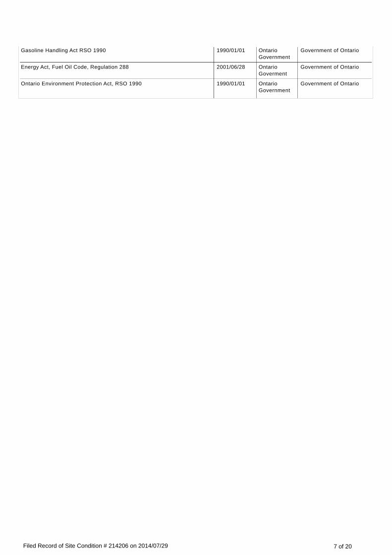
Gasoline Handling Act RSO 1990 1990/01/01 Ontario Government
Government of Ontario
Energy Act, Fuel Oil Code, Regulation 288 2001/06/28 Ontario Goverment
Government of Ontario
Ontario Environment Protection Act, RSO 1990 1990/01/01 Ontario Government
Government of Ontario
7 of 20Filed Record of Site Condition # 214206 on 2014/07/29

Phase Two Environmental Site Assessment ReportDocument used as the phase two environmental site assessment report and updates in submitting the RSC for filing
The date the last work on all of the planning of the site investigation and conducting the site investigation components of the phase two environmental site assessment was done (refer to clause 33.5(1)(a) of O. Reg. 153/04)
(YYYY/MM/DD)
2014/04/21
Type of Report
Report Title Date of Report (YYYY/MM/DD)
Author of Report
Name of ConsultingCompany
P2 ESA Commercial Lot 256 Nipissing Street, Sturgeon Falls, Ontario, Phase Two Environmental Site Assessment Report - 13/10/13196
2014/04/21 Jake Berghamer
LVM | MERLEX LTD.
Reports and Other Documents Related to the Phase Two Environmental Site AssessmentReports and other documents relied upon in making any certifications in the RSC for the purposes of Part IV of Schedule A or otherwise used in conducting the phase two environmental site assessment
Report Title Date of Report (YYYY/MM/DD).
Author of Report
Name of ConsultingCompany
Guidance Manual on Sampling, Analysi, and Data Management for Contaminated Sites - Volume I: Main Report
1993/12/01 Canadian Council of Ministers of the Environment (CCME)
Guidance Manual on Sampling, Analysis, and Data Management for Contaminated Sites - Volume II: Analytical Method Summaries
1993/12/01 Canadian Council of Ministers of the Environment (CCME)
Subsurface Assessment Handbook for Contaminated Sites 1994/03/01 Canadian Council of Ministers of the Environment (CCME)
CSA Standard Z769-00 Phase II Environmental Site Assessment 2004/01/01 Canadian Standards Association (CSA)
Maps of the National Topographic System Map 31 L/6 (North Bay) 1986/01/01 Energy, Mines and Resources Canada
Records of Site Condition - Part XV.1 of the Act 2004/01/01 Government of Ontario
Ontario Government
Ontario Environmental Protection Act 1990/01/01 Government of Ontario
Ontario Government
Phase I Environmental Site Assessment, Commerical Lot, 256 Nipissing Street, Sturgeon Falls, Ontario
2014/01/28 Jake Berghamer
LVM | Merlex Ltd.
Environmental Sampling and Analysis for Technicians 1994/01/01 Maria Csuros Lewis Publishers
Guidance on Sampling and Analytical Methods for Use at Contaminated Sites in Ontario
1996/12/01 Ontario Ministry of Environment and Energy (MOEE)
Ontario Government
8 of 20Filed Record of Site Condition # 214206 on 2014/07/29

Ontario Ministry of Environment and Energy (MOEE)
Guidance for Use at Contaminated Sites in Ontario 1997/01/01 Ontario Ministry of Environment and Energy (MOEE)
Ontario Government
Protocol for Analytical Methods Used in the Assessment of Properties under Part XV.1 of the Environmental Protection Act
2011/07/01 Ontario Ministry of the Environment (MOE)
Ontario Government
Soil, Groundwater, and Sediment Standards for Use under part XV.1 of the Environmental Protection Act
2011/04/15 Ontario Ministry of the Environment (MOE)
Ontario Government
Northern Ontario Engineering Geology Terrain Study Data Base Map - North Bay, Map 5041
1979/01/01 Ontario Ministry of Natural Resources
Ontario Government
9 of 20Filed Record of Site Condition # 214206 on 2014/07/29

Environmental ConditionSection 41 applies? No
Section 43.1 applies? No
Site Condition InformationCertification date (YYYY/MM/DD) 2014/01/28
Total area of RSC property (in hectares) 0.80000
Number of any previously filed RSC that applies to any part of the RSC property
Number of any previously filed Transition Notice that applies to any part of the RSC property
Soil Texture Coarse
Assessment/Restoration Approach Full Depth Generic
Site investigation includes the investigation, sampling and analysis of ground water? Yes
Is there soil present that is sufficient to investigate, sample and analyze soil on, in or under the property in accordance with s. 6, Schedule E of O.Reg. 153/04?
Yes
Site investigation includes the investigation, sampling and analysis of soil on, in or under the property which is used in the RSC?
Yes
Name of the laboratory used to analyze any samples collected of soil, ground water or sediment
AGAT LABORATORIES, PARACEL LABORATORIES
Ground water condition (potable, non-potable) Non-potable
Applicable Site Condition Standard TABLE 3
Local or single-tier municipality non-potable written notification date 2014/04/09
10 of 20Filed Record of Site Condition # 214206 on 2014/07/29

Table 1 – Maximum Contaminant Concentrations Compared to Applicable Site Condition Standards
Measured Concentration for Contaminants in Soil
ContaminantName
Maximum Concentration
Applicable Site Condition Standard
Unit of Measure
1 Petroleum Hydrocarbons F1**** < 5 55 µg/g
2 Petroleum Hydrocarbons F2 < 10 98 µg/g
3 Petroleum Hydrocarbons F3 < 50 300 µg/g
4 Petroleum Hydrocarbons F4 < 50 2800 µg/g
5 Benzene < 0.02 0.21 µg/g
6 Ethylbenzene < 0.05 2 µg/g
7 Toluene < 0.08 2.3 µg/g
8 Xylene Mixture < 0.05 3.1 µg/g
9 Dichlorodifluoromethane < 0.05 16 µg/g
10 Vinyl Chloride < 0.02 0.02 µg/g
11 Bromomethane < 0.05 0.05 µg/g
12 Trichlorofluoromethane < 0.05 4 µg/g
13 Acetone < 0.5 16 µg/g
14 Dichloroethylene, 1,1- < 0.05 0.05 µg/g
15 Methylene Chloride < 0.05 0.1 µg/g
16 Dichloroethylene, 1,2-trans- < 0.05 0.084 µg/g
17 Methyl tert-Butyl Ether (MTBE) < 0.05 0.75 µg/g
18 Dichloroethane, 1,1- < 0.02 3.5 µg/g
19 Methyl Ethyl Ketone < 0.5 16 µg/g
20 Dichloroethylene, 1,2-cis- < 0.02 3.4 µg/g
21 Chloroform < 0.04 0.05 µg/g
22 Dichloroethane, 1,2- < 0.03 0.05 µg/g
23 Trichloroethane, 1,1,1- < 0.05 0.38 µg/g
24 Carbon Tetrachloride < 0.05 0.05 µg/g
25 Dichloropropane, 1,2- < 0.03 0.05 µg/g
26 Trichloroethylene < 0.03 0.061 µg/g
27 Bromodichloromethane < 0.05 13 µg/g
28 Methyl Isobutyl Ketone < 0.5 1.7 µg/g
29 Trichloroethane, 1,1,2- < 0.04 0.05 µg/g
30 Dibromochloromethane < 0.05 9.4 µg/g
31 Ethylene dibromide < 0.04 0.05 µg/g
32 Tetrachloroethylene < 0.05 0.28 µg/g
33 Tetrachloroethane, 1,1,1,2- < 0.04 0.058 µg/g
34 Chlorobenzene < 0.05 2.4 µg/g
35 Bromoform < 0.05 0.27 µg/g
36 Styrene < 0.05 0.7 µg/g
37 Tetrachloroethane, 1,1,2,2- < 0.05 0.05 µg/g
38 Dichlorobenzene, 1,3- < 0.05 4.8 µg/g
39 Dichlorobenzene, 1,4- < 0.05 0.083 µg/g
11 of 20Filed Record of Site Condition # 214206 on 2014/07/29

39 Dichlorobenzene, 1,4- < 0.05 0.083 µg/g
40 Dichlorobenzene, 1,2- < 0.05 3.4 µg/g
41 Dichloropropene,1,3- < 0.04 0.05 µg/g
42 Hexane (n) < 0.05 2.8 µg/g
43 Acenaphthene < 0.05 7.9 µg/g
44 Acenaphthylene < 0.05 0.15 µg/g
45 Benz[a]anthracene < 0.05 0.5 µg/g
46 Benzo[a]pyrene < 0.05 0.3 µg/g
47 Benzo[b]fluoranthene < 0.05 0.78 µg/g
48 Benzo[ghi]perylene < 0.05 6.6 µg/g
49 Benzo[k]fluoranthene < 0.05 0.78 µg/g
50 Chrysene < 0.05 7 µg/g
51 Dibenz[a h]anthracene < 0.05 0.1 µg/g
52 Fluoranthene < 0.05 0.69 µg/g
53 Fluorene < 0.05 62 µg/g
54 Indeno[1 2 3-cd]pyrene < 0.05 0.38 µg/g
55 Naphthalene < 0.05 0.6 µg/g
56 Phenanthrene < 0.05 6.2 µg/g
57 Pyrene < 0.05 78 µg/g
58 Methlynaphthalene, 2-(1-) *** < 0.05 0.99 µg/g
59 Antimony < 0.8 7.5 µg/g
60 Arsenic 1 18 µg/g
61 Boron (total) < 5 120 µg/g
62 Barium 15 390 µg/g
63 Beryllium < 0.5 4 µg/g
64 Cadmium < 0.5 1.2 µg/g
65 Chromium Total 20 160 µg/g
66 Cobalt 3.8 22 µg/g
67 Copper 7 140 µg/g
68 Lead 2 120 µg/g
69 Molybdenum < 0.5 6.9 µg/g
70 Nickel 74 100 µg/g
71 Selenium < 0.4 2.4 µg/g
72 Silver < 0.2 20 µg/g
73 Thallium < 0.4 1 µg/g
74 Uranium 0.5 23 µg/g
75 Vanadium 25 86 µg/g
76 Zinc 13 340 µg/g
77 Polychlorinated Biphenyls < 0.1 0.35 µg/g
12 of 20Filed Record of Site Condition # 214206 on 2014/07/29

Table 1 – Maximum Contaminant Concentrations Compared to Applicable Site Condition Standards (Continued)
Ground Water
ContaminantName
Maximum Concentration
Applicable Site Condition Standard
Unit of Measure
1 Petroleum Hydrocarbons F1**** < 25 750 µg/L
2 Petroleum Hydrocarbons F2 < 100 150 µg/L
3 Petroleum Hydrocarbons F3 < 100 500 µg/L
4 Petroleum Hydrocarbons F4 < 100 500 µg/L
5 Benzene < 0.2 44 µg/L
6 Ethylbenzene < 0.1 2300 µg/L
7 Toluene < 0.2 18000 µg/L
8 Xylene Mixture < 0.1 4200 µg/L
9 Acenaphthylene < 0.2 1.8 µg/L
10 Acenaphthene < 0.2 600 µg/L
11 Anthracene < 0.1 2.4 µg/L
12 Benz[a]anthracene < 0.2 4.7 µg/L
13 Benzo[a]pyrene < 0.01 0.81 µg/L
14 Benzo[b]fluoranthene < 0.1 0.75 µg/L
15 Benzo[ghi]perylene < 0.2 0.2 µg/L
16 Benzo[k]fluoranthene < 0.1 0.4 µg/L
17 Chrysene < 0.1 1 µg/L
18 Dibenz[a h]anthracene < 0.2 0.52 µg/L
19 Fluoranthene < 0.2 130 µg/L
20 Fluorene < 0.2 400 µg/L
21 Indeno[1 2 3-cd]pyrene < 0.2 0.2 µg/L
22 Methlynaphthalene, 2-(1-) *** < 0.2 1800 µg/L
23 Naphthalene < 0.2 1400 µg/L
24 Phenanthrene < 0.1 580 µg/L
25 Pyrene < 0.2 68 µg/L
26 Tetrachloroethane, 1,1,1,2- < 0.1 3.3 µg/L
27 Trichloroethane, 1,1,1- < 0.3 640 µg/L
28 Tetrachloroethane, 1,1,2,2- < 0.1 3.2 µg/L
29 Trichloroethane, 1,1,2- < 0.2 4.7 µg/L
30 Dichloroethane, 1,1- < 0.3 320 µg/L
31 Dichloroethylene, 1,1- < 0.3 1.6 µg/L
32 Dichlorobenzene, 1,2- < 0.1 4600 µg/L
33 Dichloroethane, 1,2- < 0.2 1.6 µg/L
34 Dichloropropane, 1,2- < 0.2 16 µg/L
35 Dichlorobenzene, 1,3- < 0.1 9600 µg/L
36 Dichloropropene,1,3- < 0.3 5.2 µg/L
37 Dichlorobenzene, 1,4- < 0.1 8 µg/L
38 Acetone < 1 130000 µg/L
39 Bromodichloromethane < 0.2 85000 µg/L
13 of 20Filed Record of Site Condition # 214206 on 2014/07/29

39 Bromodichloromethane < 0.2 85000 µg/L
40 Bromoform < 0.1 380 µg/L
41 Bromomethane < 0.2 5.6 µg/L
42 Carbon Tetrachloride < 0.2 0.79 µg/L
43 Chlorobenzene < 0.1 630 µg/L
44 Chloroform < 0.2 2.4 µg/L
45 Dichloroethylene, 1,2-cis- < 0.2 1.6 µg/L
46 Dibromochloromethane < 0.1 82000 µg/L
47 Dichlorodifluoromethane < 0.2 4400 µg/L
48 Ethylene dibromide < 0.1 0.25 µg/L
49 Methyl Ethyl Ketone < 1 470000 µg/L
50 Methyl Isobutyl Ketone < 1 140000 µg/L
51 Methyl tert-Butyl Ether (MTBE) < 0.2 190 µg/L
52 Methylene Chloride < 0.3 610 µg/L
53 Hexane (n) < 0.2 51 µg/L
54 Styrene < 0.1 1300 µg/L
55 Tetrachloroethylene < 0.2 1.6 µg/L
56 Dichloroethylene, 1,2-trans- < 0.2 1.6 µg/L
57 Trichloroethylene < 0.2 1.6 µg/L
58 Trichlorofluoromethane < 0.4 2500 µg/L
59 Vinyl Chloride < 0.17 0.5 µg/L
60 Antimony < 0.5 20000 µg/L
61 Arsenic 1.7 1900 µg/L
62 Barium 83.9 29000 µg/L
63 Beryllium < 0.5 67 µg/L
64 Boron (total) 15.7 45000 µg/L
65 Cadmium < 0.2 2.7 µg/L
66 Chromium Total 2.9 810 µg/L
67 Cobalt 1.5 66 µg/L
68 Copper 1 87 µg/L
69 Lead < 0.5 25 µg/L
70 Molybdenum < 0.5 9200 µg/L
71 Nickel 385 490 µg/L
72 Selenium < 1 63 µg/L
73 Silver < 0.2 1.5 µg/L
74 Thallium < 0.3 510 µg/L
75 Uranium < 0.5 420 µg/L
76 Vanadium 1.4 250 µg/L
77 Zinc < 5 1100 µg/L
78 Polychlorinated Biphenyls < 0.1 7.8 µg/L
14 of 20Filed Record of Site Condition # 214206 on 2014/07/29

Remedial Action and Mitigation
Remediated Soils
Estimated quantities of the soil, if any, originating at and remaining on the RSC property that have been remediated, at a location either on or off the property, to reduce the concentration of contaminants in the soil. Indicate the remediation process or processes used and the estimated amount of soil remediated by each identified process.
Soil Remediation Process Estimated Quantity of Soil (in-ground volume in m³)
Description of Remediation
Description of any action taken to reduce the concentration of contaminants (including soil removals) on, in or under the RSC property.
Soil or Sediment Removed and Not Returned
Estimated quantities of soil or sediment, if any, removed from and not returned to the RSC property.
Estimated Quantity of Soil (in-ground volume in m³)
Estimated Quantity of Sediment (in-ground volume in m³)
Soil Brought to the Property
Estimated quantity of the soil, if any, being brought from another property to and deposited at the RSC property, not including any soil that may have originated at but been remediated off the RSC property and that is identified in section 28 of Schedule A.
Estimated Quantity of Soil Brought to the Property(in-ground volume in m³)
432.0
15 of 20Filed Record of Site Condition # 214206 on 2014/07/29

Ground Water Control or Treatment Measures
Ground water control or treatment measures that were required for the RSC property prior to the certification date for the purpose of submitting the RSC for filing.
Ground water control or treatment measures that are required for the RSC property after the certification date.
Estimated volume of ground water, if any, removed from and not returned to the RSC property.
Estimated Volume of Ground Water (in litres)
16 of 20Filed Record of Site Condition # 214206 on 2014/07/29
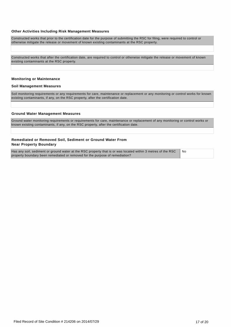
Other Activities Including Risk Management Measures
Constructed works that prior to the certification date for the purpose of submitting the RSC for filing, were required to control or otherwise mitigate the release or movement of known existing contaminants at the RSC property.
Constructed works that after the certification date, are required to control or otherwise mitigate the release or movement of known existing contaminants at the RSC property.
Monitoring or Maintenance
Soil Management Measures
Soil monitoring requirements or any requirements for care, maintenance or replacement or any monitoring or control works for known existing contaminants, if any, on the RSC property, after the certification date.
Ground Water Management Measures
Ground water monitoring requirements or requirements for care, maintenance or replacement of any monitoring or control works or known existing contaminants, if any, on the RSC property, after the certification date.
Remediated or Removed Soil, Sediment or Ground Water From Near Property Boundary
Has any soil, sediment or ground water at the RSC property that is or was located within 3 metres of the RSC property boundary been remediated or removed for the purpose of remediation?
No
17 of 20Filed Record of Site Condition # 214206 on 2014/07/29
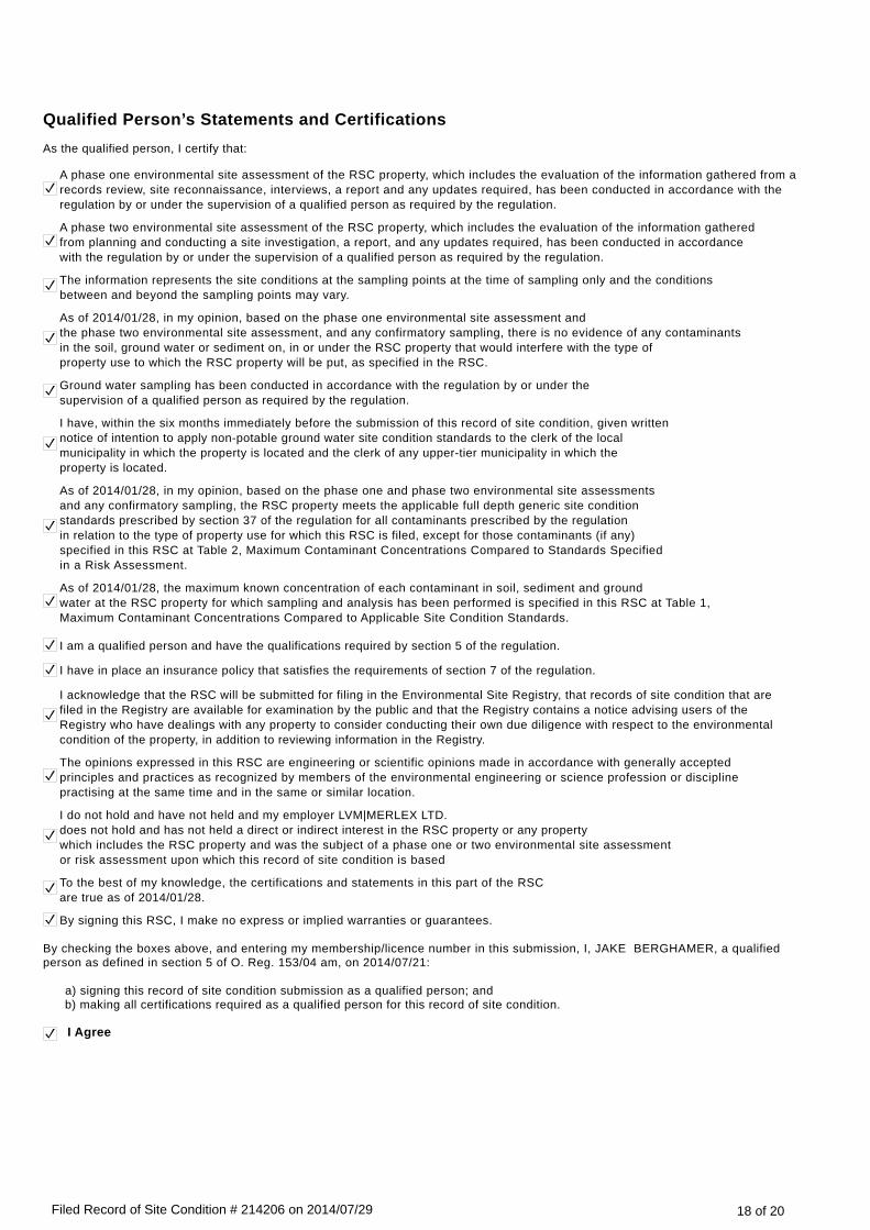
Qualified Person’s Statements and CertificationsAs the qualified person, I certify that:
A phase one environmental site assessment of the RSC property, which includes the evaluation of the information gathered from a records review, site reconnaissance, interviews, a report and any updates required, has been conducted in accordance with the regulation by or under the supervision of a qualified person as required by the regulation.
A phase two environmental site assessment of the RSC property, which includes the evaluation of the information gathered from planning and conducting a site investigation, a report, and any updates required, has been conducted in accordance with the regulation by or under the supervision of a qualified person as required by the regulation.
The information represents the site conditions at the sampling points at the time of sampling only and the conditions between and beyond the sampling points may vary.
As of 2014/01/28, in my opinion, based on the phase one environmental site assessment and the phase two environmental site assessment, and any confirmatory sampling, there is no evidence of any contaminants in the soil, ground water or sediment on, in or under the RSC property that would interfere with the type of property use to which the RSC property will be put, as specified in the RSC.
Ground water sampling has been conducted in accordance with the regulation by or under the supervision of a qualified person as required by the regulation.
I have, within the six months immediately before the submission of this record of site condition, given written notice of intention to apply non-potable ground water site condition standards to the clerk of the local municipality in which the property is located and the clerk of any upper-tier municipality in which the property is located.
As of 2014/01/28, in my opinion, based on the phase one and phase two environmental site assessments and any confirmatory sampling, the RSC property meets the applicable full depth generic site condition standards prescribed by section 37 of the regulation for all contaminants prescribed by the regulation in relation to the type of property use for which this RSC is filed, except for those contaminants (if any) specified in this RSC at Table 2, Maximum Contaminant Concentrations Compared to Standards Specified in a Risk Assessment.
As of 2014/01/28, the maximum known concentration of each contaminant in soil, sediment and ground water at the RSC property for which sampling and analysis has been performed is specified in this RSC at Table 1, Maximum Contaminant Concentrations Compared to Applicable Site Condition Standards.
I am a qualified person and have the qualifications required by section 5 of the regulation.
I have in place an insurance policy that satisfies the requirements of section 7 of the regulation.
I acknowledge that the RSC will be submitted for filing in the Environmental Site Registry, that records of site condition that are filed in the Registry are available for examination by the public and that the Registry contains a notice advising users of the Registry who have dealings with any property to consider conducting their own due diligence with respect to the environmental condition of the property, in addition to reviewing information in the Registry.
The opinions expressed in this RSC are engineering or scientific opinions made in accordance with generally accepted principles and practices as recognized by members of the environmental engineering or science profession or discipline practising at the same time and in the same or similar location.
I do not hold and have not held and my employer LVM|MERLEX LTD.does not hold and has not held a direct or indirect interest in the RSC property or any property which includes the RSC property and was the subject of a phase one or two environmental site assessmentor risk assessment upon which this record of site condition is based
To the best of my knowledge, the certifications and statements in this part of the RSCare true as of 2014/01/28.
By signing this RSC, I make no express or implied warranties or guarantees.
By checking the boxes above, and entering my membership/licence number in this submission, I, JAKE BERGHAMER, a qualified person as defined in section 5 of O. Reg. 153/04 am, on 2014/07/21:
a) signing this record of site condition submission as a qualified person; and b) making all certifications required as a qualified person for this record of site condition.
I Agree
18 of 20Filed Record of Site Condition # 214206 on 2014/07/29

Additional Documentation Provided by Property Owner or AgentThe following documents have been submitted to the Ministry of the Environment as part of the record of site condition
Lawyer’s letter consisting of a legal description of the property
Copy of any deed(s), transfer(s) or other document(s) by which the RSC property was acquired
A Current plan of Survey
Area(s) of Potential Environmental Concern
Table of Current and Past Uses of the Phase One Property
Phase 2 Conceptual Site Model
Owner or agent certification statements
v 4.1.1
19 of 20Filed Record of Site Condition # 214206 on 2014/07/29

As an owner of the RSC ProPertY:
2. I have conducted reasonable inquiries to obtain all information relevant to thisnSd,-inctuOinglnfoimation_from the other current owners of the nSC_ q^r9991!yhlmeO in inii "part of the RSC and I have obtained all information relevant to thisRSC of which I am aware'
3. I have disclosed all information referred to in paragraph2 to any qualified personnamed in this RSC.
4. To mv knowle.dqe, thg statements made in this part of the RSC are true as of4
5. I have *ensured
that access to the entire p-rqperty, including. the phase onepropertv, anv prrase two property and the RSC'prgneflv, has been afforded toi6J-duZiiridd fie'rson-5no'to-pefsons superviseil by tfie qualified person, forpurpdses of c6nducting the site reconnaissance.
Name or o*n",.figffeSeg CCal
Signature Date sisneo -lult/ 33/ AA,4
20 of 20Filed Record of Site Condition # 214206 on 2014/07/29

Michel Law Office Avocat - Notaire • Barrister - Solicitor
ALAIN A. MICHEL B.A. (HONS) L.L.B.
42, Rue Principale Street E., C.P.lBox 310, Verner ON POH 2MO Tel. (705) 594"1212 Fax. (705) 594-1062
April 15, 2014
LVM Merlex Ltd. 2-120 Progress Court North Bay ON P1A OC2
Attention: Victoria Steuernol
Dear Mrs. Steuernol,
Re: Pierre and Stephanie Senecal 256 Nipissing Street
I am the solicitor for Pierre and Stephanie Senecal. I hereby confirm as follows:
1) Legal description: PIN 49080-0697 part lot 3 con 1, Springer SRO Part 1, 36R-10553, West Nipissing; District of Nipissing
2) Municipal address: 256 Nipissing Street Sturgeon Falls ON
3) Roll # 485201000507575.0000
4) Owners:
Yours very tr=.:ulc,u.-. ____
~lain A. Michel
AAM/ar
Pierre Senecal Stephanie Josette Senecal as joint tenants fee simple


AreasofPotentialEnvironmentalConcern
AREA OF
POTENTIAL
ENVIRONMENTAL
CONCERN
LOCATION OF AREA OF
POTENTIAL
ENVIRONMENTAL CONCERN
ON PHASE ONE PROPERTY
POTENTIALLY
CONTAMINATING ACTIVITY
LOCATION
OF PCA
CONTAMINANTS OF
POTENTIAL
CONCERN
MEDIA
POTENTIALLY
IMPACTED
APEC 1 North boundary of Site.
Rail line (27, 46), fuel storage (28), former fuel storage (28), former oil storage tanks (14), vehicle maintenance (52).
Off-Site PHCs F1 – F4, BTEX, PAHs, Metals
Soil, Groundwater
APEC 2 East boundary of the Site. Use of paints and solvents (39), oil storage tank (14).
Off-Site PHCs F1 – F4, PAHs, VOCs
Soil, Groundwater
APEC 3 West boundary of the Site. Metal fabricating (34), oil storage tanks (14), PCB storage site (8).
Off-Site PHCs F1 – F4, PAHs, BTEX, Metals, PCBs
Soil, Groundwater
APEC 4 West end of Site around construction.
Imported fill of unknown quality (30).
On-Site PHCs F1 – F4, BTEX
Soil

Current and Past Uses of the Phase Two Property
YEAR NAME OF OWNER DESCRIPTION OF PROPERTY USE
PROPERTY USE1 OTHER OBSERVATIONS FROM AERIAL PHOTOGRAPHS, FIRE INSURANCE
PLANS, ETC.
2013 – Present
Pierre Sénécal, Stephanie Josette Sénécal
Vacant Commercial Currently being redeveloped. 2012 Satellite image shows Site as supporting a vacant field of vegetation.
2000 – 2013 Carl Maurice, Carole Maurice
Vacant Commercial Google Street View shows the Site being used to sell fresh produce. This is reportedly a seasonal, short-period use of the Site.
1989 – 2000 Ranik Inc. / 814294 Ontario Inc.
Vacant / Possibly Agricultural
Commercial In a 1989 aerial photograph, the building associated with the mini golf appears to have been demolished. The eastern portion of the Site appears to be used for agricultural purposes.
1981 – 1989 Nipissing Bus Lines Ltd.
Possibly mini golf / possibly agricultural
Commercial Title search records indicate a grant of easement was given to the Town of Sturgeon Falls in 1987 for water main installation and maintenance. A portion of the Property was transferred to 814294 Ontario Ltd. (a.k.a. Ranik Inc.in 1989. According to local residence, the mini golf operation ended in the early 1980’s.
1980 – 1981 Gerald St. Jacques, Ivan Lalonde
Mini golf / agricultural
Commercial In a 1980 aerial photograph, the mini golf operation on the west end of the Site appears to be functioning and the eastern portion of the Site appears to be used for agricultural purposes.
1976 – 1980 Marathon Realty Company
Mini golf / possibly agricultural
Commercial In a 1977 aerial photograph, the mini golf operation appears to be present and the eastern portion of the Site appears as though it may be used for agricultural purposes.
1884 – 1976 Canadian Pacific Railway Co.
Vacant / possibly agricultural.
Industrial First Developed Use. A 1929 aerial photo shows the Site as vacant, likely supporting grasses, with a pedestrian path running diagonally northwest to southeast through the west end. However, the rail line has been constructed to the north of the Subject Site and the property was owned at that time by the Canadian Pacific Railway Co. Therefore, the first developed use was part of the railway corridor even though no structures or buildings were present on the Subject Site itself. Aerial Photos from 1951 and 1970 show that the Subject Site is vacant or possibly used for agricultural purposes.
Pre – 1884 Crown Land Vacant Agricultural or other
Land not used, no developments.
Notes:
1 – Regulatory Types as defined in O. Reg. 153/04

13/10/13196
PHASE TWO ESA - CONCEPTUAL SITE MODEL – 256 NIP ISSING STREET, STURGEON FALLS, ONTARIO
1
PHASE TWO CONCEPTUAL SITE MODEL
Discussion of the Conceptual Site Model (CSM) of the Phase Two Study Area
LVM | Merlex Ltd. has created several figures to help in understanding the current and historical
conditions of the original Phase One and Two Property, the Phase One Study Area, and the RSC
Property. These figures make up the Conceptual Site Model (CSM) and are discussed below. The
Phase Two CSM is provided and discussed in this section, as required under O. Reg. 153/04, as
amended. The CSM is based on recent Phase Two ESA work. The approximate location of the new
building as well as the area of imported fill on the Site is outlined in the figures. The figures are included
in Appendix 1.
I. Potentially Contaminating Activities and Areas of Potential Environmental Concern
The Phase One and Two Property (identical boundaries) are located in the Municipality of Sturgeon Falls,
Ontario (see Drawing No. 1b, Appendix 1).
During the Phase One ESA (LVM | Merlex Ltd., 2013/2014, Ref. No. 13/10/13196), three (3) APECs
attributable to historical and current PCAs situated within 250 m of the Phase Two Property were
identified. One (1) PCA resulting in an APEC was identified on the Site. No other PCAs were identified
located within 250 m of the Phase Two Property boundaries. PCAs and APECs are discussed below and
illustrated on Drawing No. 4 in Appendix 1.
On-Site PCAs resulting in an APEC at the RSC Property
One (1) PCA resulting in an APEC was identified on the Site (RSC One Property). The west/southwest
end of the Site around the area of the newly constructed building has been backfilled and graded with
imported fill of unknown quality (PCA #30). The contaminants of concern potentially associated with
excavating the fill from the original source off-Site, transporting the fill to the Phase II Property, and
grading the fill at the Phase II Property, are PHCs in the F1 – F4 range and BTEX compounds.
Off-Site PCAs resulting in APECs at the RSC Property
Three (3) PCAs were identified on properties adjacent to the Site that resulted in APECs along the
boundaries of the RSC Property.
PCA 1 is located off-Site along the north boundary of the Site and includes a rail line (PCA #46) and the
area immediately adjacent to the rail line to the north where there is a fuel storage area (PCA #28) and a
vehicle maintenance operation (PCA #27). As these PCAs are adjacent to the site to the north and
considered up gradient they result in an APEC along the north boundary of the Site (APEC 1).
Contaminants of concern in this area include PHCs F1 – F4, BTEX, PAHs, and metals.
PCA 2 is located off-Site along the east boundary of the Site and includes a sign manufacturer (PCA #8
and #39) with a fuel oil AST (PCA #28) servicing the building. As these PCAs are adjacent to the site to
the east and considered up/cross gradient they result in an APEC along the east boundary of the Site
(APEC 2). Contaminants of concern in this APEC include PHCs F1 – F4, PAHs, and VOCs.

13/10/13196
PHASE TWO ESA - CONCEPTUAL SITE MODEL – 256 NIP ISSING STREET, STURGEON FALLS, ONTARIO
2
PCA 3 was identified off-Site along the west boundary of the Property and involved a welding/fabricating
shop (PCA #34) opposite Nipissing Street, and the historical and possible ongoing PCB storage site (PCA
#8). As these PCAs are adjacent to the Site to the west and considered cross/down gradient they result in
an APEC along the west boundary of the Site (APEC 1). Contaminants of concern in this APEC include
PHCs F1 – F4, PAHs, BTEX, PCBs, and metals.
The APECs occurring on the Phase Two Property have been thoroughly investigated for all associated
COCs. Contaminants of concern were above the applicable MOE SCS not identified in any APECs on the
Subject Site.
Contaminants of concern were found to be below the applicable MOE SCS for all identified APECs on
and off the Subject Site.
AREA OF POTENTIAL
ENVIRONMENTAL
CONCERN
LOCATION OF AREA OF POTENTIAL
ENVIRONMENTAL CONCERN ON PHASE
ONE PROPERTY
POTENTIALLY CONTAMINATING
ACTIVITY*
LOCATION OF PCA
CONTAMINANTS OF POTENTIAL
CONCERN
MEDIA POTENTIALLY
IMPACTED
APEC 1 North boundary of Site.
Rail line (46), fuel storage (28), former fuel storage (28), former oil storage tanks (14), vehicle maintenance (52).
Off-Site PHCs F1 – F4, BTEX, PAHs, Metals
Soil, Groundwater
APEC 2 East boundary of the Site.
Use of paints and solvents (39), oil storage tank (14).
Off-Site PHCs F1 – F4, PAHs, VOCs
Soil, Groundwater
APEC 3 West boundary of the Site.
Metal fabricating (34), oil storage tanks (14), PCB storage site (8).
Off-Site PHCs F1 – F4, PAHs, BTEX, Metals, PCBs
Soil, Groundwater
APEC 4 West end of Site around construction.
Imported fill of unknown quality (30).
On-Site PHCs F1 – F4, BTEX
Soil
* Refers to Ontario Regulation 153/04, Part 6, Table 2 – Potentially Contaminating Activities; O. Reg. 511/09, s.31; O. Reg. 245/10, s.5 (1,2); O. Reg. 179/11, s.7; O. Reg. 269/11, s.2.

13/10/13196
PHASE TWO ESA - CONCEPTUAL SITE MODEL – 256 NIP ISSING STREET, STURGEON FALLS, ONTARIO
3
II. Subsurface Structures and Utilities
At the time of this investigation, a municipal drinking water line was known to be present in the subsurface
as it was previously associated with Site operations (mini-putt) located on the RSC Property. No other
subsurface structures or utilities were identified.
Physical Characteristics
I. Stratigraphy from ground surface to the deepest aquifer or aquitard investigated
Geologic cross sections were constructed to illustrate the stratigraphy at the Site. The cross section
locations are shown on Drawing No. 5 and the cross sections A‐A’ and B‐B’ are illustrated on Drawing No.
6.
II. Hydrogeological Characteristics
The geodetic elevation of the Site is approximately ±212 m above sea level (Google Earth, 2013). Based
upon local geological mapping (Ontario Ministry of Natural Resources, Northern Ontario Engineering
Geology Terrain Study Data Base Map – North Bay, Map 5041, 1979), the subsurface conditions are
comprised of glaciolacustrine plains made up of silty sands as the dominant landform. The topographic
variety of the dominant landform is considered to be a plain, or flat. Local relief is considered to be mainly
low and drainage is dry with a suspected high water table.
Groundwater levels were encountered between 1.55 to 2.06 metres below original ground surface
(mbgs), with an inferred flow direction southwesterly, towards the Sturgeon River and eventually
Lake Nipissing.
The topography of the Site slopes down from northeast to southwest, towards the Sturgeon River,
eventually leading to Lake Nipissing.
There are no known environmentally sensitive areas in the study area of the Site.
The permeability of the main geological units was estimated as follows:
Sand fill: 10-1 to 10-5 cm/sec Natural Sands: 10-1 to 10-3 cm/sec
Based on the Site-specific geology, the main units investigated during the Phase Two ESA were the fill
and the native sand units, and wells were constructed to straddle the encountered groundwater table.
Groundwater measurements based upon one sampling event on Site ranged from 1.55 mbgs to 2.06
mbgs and groundwater flow was shown to flow to the southwest.
The horizontal gradient across the Site was measured as approximately 3.44 x 10⁻³ metres per metre
(m/m).
III. Approximate depth to bedrock
The approximate depth to bedrock on Site is unknown as boreholes were advanced to 4.5 mbgs and
bedrock was not encountered.

13/10/13196
PHASE TWO ESA - CONCEPTUAL SITE MODEL – 256 NIP ISSING STREET, STURGEON FALLS, ONTARIO
4
Bedrock elevations in the area are known to be highly variable, with significant elevation differences over
short horizontal distances. Based upon available records, the estimated depth to bedrock in the area of
the Site is 5 to >20 mbgs based on local spot elevations of known bedrock outcrops at surface (Google
Earth, 2013), and data from the LVM-Merlex Historical Geotechnical Database. The bedrock surface at
Minnehaha Bay, located approximately 500 m to the west-south-west of the Site was encountered at
elevations ranging from 200.6 m to 193.8 m during a 2009 Geotechnical Investigation (LVM-Merlex,
2009).
IV. Approximate depth to water table
Groundwater measurements based upon one sampling event on Site ranged from 1.55 mbgs to 2.06
mbgs and groundwater flow was shown to flow to the southwest. The groundwater contours and
interpreted groundwater flow direction are presented on Drawing 3 found in Appendix 1.
V. Any respect in which section 41 or 43.1 of the Regulation applies to the property
In regards to section 41 of O. Reg. 153/04:
a) The Property:
i. is not situated within an area of natural significance;
ii. does not include, nor is it adjacent to, an area of natural significance or part of such an
area;
iii. does not include land that is within 30 metres of an area of natural significance or part of
such an area.
b) Soil with pH values outside of the acceptable ranges was not identified on the subject site
In regards to section 43.1 of O. Reg. 153/04:
a) The Property:
i. is not a shallow soil property;
ii. does not include all or part of a water body, nor is it adjacent to a water body, and does
not include land that is within 30 m of a water body.
Sections 41 and 43.1 do not apply to the subject site.
VI. Areas where soil has been brought from another property and placed on, in or under the Phase Two Property
Granular fill is present in the western portion of the Site for developing the office/residential building now
present on Site. It is reported by the builder that the quantity of fill brought to the site was 432 m3. On
March 3rd, 2014, three (3) soil samples (one for every 160 m3 of soil brought to the site) plus a duplicate
soil sample were obtained from the fill brought to the Site. The samples were analytically tested for
contaminants of concern (COCs) that may have come into contact with the soil during removal from the
pit, transportation, and grading on the RSC Property. COCs included BTEX and PHCs in F1 to F4
ranges. None of the COCs were present in any of the soil samples at concentrations exceeding
applicable MOE SCS.

13/10/13196
PHASE TWO ESA - CONCEPTUAL SITE MODEL – 256 NIP ISSING STREET, STURGEON FALLS, ONTARIO
5
VII. Approximate locations of proposed building or structures
A new mixed use commercial/residential building was constructed at the Phase Two Property in the area
of the southwest quadrant of the Site.

13/10/13196
PHASE TWO ESA - CONCEPTUAL SITE MODEL – 256 NIP ISSING STREET, STURGEON FALLS, ONTARIO
6
Additional Information Soil Quality
Environmental conditions within the soils were characterized based on the analytical results of soil
samples obtained during the Phase Two ESA field investigation.
Three (3) sampled boreholes (all of which were developed with monitoring wells), and three (3) auger
probes, were advanced on the RSC Property.
One (1) sampled borehole developed with monitoring well was advanced in each of APECs 1, 2 and 3.
COCs were not detected in any of the submitted soil samples obtained from the RSC Property at
concentrations that exceed the applicable Site Condition Standards (SCS) (see Certificates of Analysis in
Appendix 3).
Granular fill is present in the western portion of the Site for developing the office/residential building now
present on Site. It is reported by the builder that the quantity of fill brought to the site was 432 m3. On
March 3rd, 2014, three (3) soil samples (one for every 160 m3 of soil brought to the site) plus a duplicate
soil sample were obtained from the fill brought to the Site. The samples were analytically tested for
contaminants of concern (COCs) that may have come into contact with the soil during removal from the
pit, transportation, and grading on the RSC Property. COCs included BTEX and PHCs in F1 to F4
ranges. None of the COCs were present in any of the soil samples at concentrations exceeding
applicable MOE SCS.
For a complete list of results, see Appendix 3 for the Certificate of Analysis provided by AGAT Laboratory.
The soil quality investigation concluded that none of the PCAs has resulted in a confirmed area of
environmental concern and therefore no additional environmental work was required at the RSC Property.
Groundwater Quality
Environmental conditions within the groundwater were characterized based on the analytical results of
groundwater samples obtained during the Phase II ESA field investigation.
Three (3) monitoring wells were constructed on the RSC Property, one in each of APEC 1, 2, and 3. No
COCs were detected at concentrations that exceed the applicable site condition standards from any of
the groundwater samples obtained from the RSC One Property. For further detail, see the Certificate of
Analysis found in Appendix 3 of this report.
The combined results of the soil and groundwater samples lead to the conclusion that no additional
environmental work was required for the APECs located on the Phase Two Property.
Vapour Intrusion
Vapour intrusion was not investigated as part of the Phase Two ESA as there was no occupied buildings
located on the Phase Two Property at the time of the ESA II field investigation. A new building is currently
under construction. Based on the soil and water quality findings, a vapour intrusion investigation does not
appear to be warranted.

13/10/13196
PHASE TWO ESA - CONCEPTUAL SITE MODEL – 256 NIP ISSING STREET, STURGEON FALLS, ONTARIO
7
Contaminant Pathways and Receptors
Based on the analytical results of the soil and groundwater samples obtained from the ESA Phase II
property meeting the applicable MOE SCS, it is LVM | Merlex Ltd.’s opinion that it is not necessary to
carry out a study of the human health and ecological contaminant pathway and receptor models,
identifying the source, release mechanisms, transport pathways, human and ecological receptors on, in
or under the RSC Property, and types and routes of receptor exposure. See Drawing No.’s 6 and 7 in
Appendix 1.
Proposed Future Land Use
The proposed future land use is mixed Commercial and Residential.


Source Release and Transport Mechanisms Exposure Pathway Potential Receptors
Historical Fuel
Storage,
Vehicle
Maintenance
and Rail Line,
PCB Storage
Site, Use of
Paints and
Solvents,
Metal
Fabricating,
Imported Fill
Infiltration through
concrete slab
Soil
PHCs, PAHs,
VOCs, BTEX,
PCBs, Select
Metals
Dermal Contact Soil Organisms
Ingestion Terrestrial Biota
Vapour and Soil
InhalationBirds and Mammals
Direct Contact Terrestrial Plants
Building removed Leaching Root Uptake
Natural recharge Groundwater
PHCs, PAHs,
VOCs, BTEX,
PCBs, Select
Metals
Dermal Contact Soil Organisms
Vapour Inhalation Birds and Mammals
Direct Contact Terrestrial Plants
Root Uptake Aquatic Biota
Legend:
Exposure Pathway from COC
Negligable Exposure Pathway
Contaminant Pathways and Receptors ‐ Ecological

Source Exposure Pathway
Site Residen
t
Site Visitor
Rep
etitive Short‐
term
Visitors
Construction W
orker
Historical Fuel
Storage, Vehicle
Maintenance and Rail
Line, PCB Storage
Site, Use of Paints
and Solvents, Metal
Fabricating, Imported
Fill
Infiltration
through concrete
slab and soil
Soil
PAHs, PHCs, VOCs,
BTEX, PCBs, Select
Metals
Ingestion and
Dermal Contact
Wind Erosion Airborne
ParticlesInhalation
VolatizationOutdoor Air
Inhaltion and
Dermal Contact
VolatizationIndoor Air
Inhaltion and
Dermal Contact
LeachingPlant Uptake Garden
ProduceIngestion
Natural recharge
Groundwater
PAHs, PHCs, VOCs,
BTEX, PCBs, Select
Metals
Ingestion and
Dermal Contact
VolatizationOutdoor Air
Inhaltion and
Dermal Contact
VolatizationIndoor Air
Inhaltion and
Dermal Contact
Plant Uptake Garden
ProduceIngestion
Legend:
Exposure Pathway from COC
Negligable Exposure Pathway
Receptor
Potential ReceptorsRelease and Transport Mechanisms
Contaminant Pathways and Receptors ‐ Human Health