ontario ministry of the environment and climate change ... 217210.pdf · ontario ministry of the...
TRANSCRIPT

Ontario Ministry of the Environment and Climate Change - Record of Site Condition # 217210
Record of Site Condition
Under Part XV.1 of the Environment Protection Act
Summary
Notice to Readers Concerning Due Diligence
This record of site condition has been filed in the Environmental Site Registry to which the public has
access and which contains a notice advising users of the Environmental Site Registry who have dealings
with any property to consider conducting their own due diligence with respect to the environmental
condition of the property, in addition to reviewing information in the Environmental Site Registry.
Contents of this Record of Site Condition
This record of site condition consists (RSC) of this document which is available to be printed directly from
the Environmental Site Registry as well as all supporting documentation indicated in this RSC to have been
submitted in electronic format to the Ministry of the Environment and Climate Change.
Record of Site Condition Number 217210Date Filed to Environmental Site Registry 2015/03/20Certification Date 2014/10/31Current Property Use CommercialIntended Property Use ResidentialCertificate of Property Use Number No CPUApplicable Site Condition Standards** Full Depth Generic Site Conditions Standard,
with Potable Ground Water, Medium and FineTextured Soil, for Residential property use
Property Municipal Address 1198 QUEEN STREET NORTH, NEWDUNDEE, ON, N0B 2E0
1 of 16Filed Record of Site Condition # 217210 on 2015/03/20

PART 1: PROPERTY OWNERSHIP, PROPERTY INFORMATION AND OWNER'S CERTIFICATIONS
Information about the owner who is submitting or authorizing the submission of the RSC
Owner Name 1907172 ONTARIO INC.
Authorized Person WALTER VEUGEN
Mailing Address 60 WALTER KURT PLACE, NEW DUNDEEONTARIO, CANADA
Postal Code N0B 2E0
Phone (519) 620-8925
Fax
Email Address [email protected]
2 of 16Filed Record of Site Condition # 217210 on 2015/03/20

RSC Property Location Information
Municipal Address(es) 1198 QUEEN STREET NORTH, NEW DUNDEE, ON N0B 2E0
Municipality Wilmot
Legal Description See Attached Lawyer’s Letter
Assessment Roll Number(s)
301802000204300
Property Identifier Number(s)
22206-0062 (LT)
RSC Property Geographical References
Coordinate System UTM
Datum NAD 83
Zone 17
Easting 537,371.49
Northing 4,799,847.17
RSC Property Use Information
The following types of property uses are defined by the Regulation: Agricultural or other use, Commercial use, Community use, Industrial use, Institutional use, Parkland use, and Residential use.
Current Property Use Commercial
Intended Property Use Residential
Certificate of Property Use has been issued under section 168.6 of the EPA
No
3 of 16Filed Record of Site Condition # 217210 on 2015/03/20

Please See the Signed Statements of Property Owner, or Agent, or Receiver at the End of this RSC
The rest of this page has been left intentionally blank
4 of 16Filed Record of Site Condition # 217210 on 2015/03/20

PART 2: LIST OF REPORTS, SUMMARY OF SITE CONDITIONS AND QUALIFIED PERSON’S STATEMENTS AND CERTIFICATIONSQualified Person's Information
Name TANYA SMITH
Type of Licence Under Professional Engineers Act
Licence
Licence Number 100072221
QP Employer Name XCG CONSULTANTS LIMITED
Mailing Address 820 TRILLIUM DRIVE, KITCHENERONTARIO, N2R 1K4 CANADA
Phone (519) 741-5774
Fax (519) 741-5627
Email Address [email protected]
Municipal Information
Local or Single-Tier Municipality
Wilmot
Upper-Tier Municipality Waterloo
Ministry of the Environment and Climate Change District Office
District Office Guelph District Office
District Office Address 1 Stone Road W., Guelph ON N1G 4Y2
5 of 16Filed Record of Site Condition # 217210 on 2015/03/20

Phase One Environmental Site Assessment ReportDocument used as the phase one environmental site assessment report and updates in submitting the RSC for filing
The date the last work on all of the records review, interviews and site reconnaissance components of the phase one environmental site assessment was done (refer to clause 28(1)(a) of O. Reg. 153/04)
(YYYY/MM/DD)
2015-01-13
Type of Report
Report Title Date of Report (YYYY/MM/DD)
Author of Report
Name of ConsultingCompany
P1 ESA PHASE ONE ENVIRONMENTAL SITE ASSESSMENT, SOUTH PORTION OF 1198 QUEEN STREET NORTH, NEW DUNDEE, ONTARIO
2015-01-28 Tanya Smith XCG CONSULTANTS LTD.
Reports and Other Documents Related to the Phase One Environmental Site AssessmentReports and other documents relied upon in certifying the information set out in section 10 of Schedule A or otherwise used in conducting the phase one environmental site assessment
Report Title Date of Report (YYYY/MM/DD)
Author of Report
Name of ConsultingCompany
N/A
6 of 16Filed Record of Site Condition # 217210 on 2015/03/20

Phase Two Environmental Site Assessment ReportDocument used as the phase two environmental site assessment report and updates in submitting the RSC for filing
The date the last work on all of the planning of the site investigation and conducting the site investigation components of the phase two environmental site assessment was done (refer to clause 33.5(1)(a) of O. Reg. 153/04)
(YYYY/MM/DD)
2014-10-31
Type of Report
Report Title Date of Report (YYYY/MM/DD)
Author of Report
Name of ConsultingCompany
P2 ESA PHASE TWO ENVIRONMENTAL SITE ASSESSMENT, SOUTH PORTION OF 1198 QUEEN STREET NORTH, NEW DUNDEE, ONTARIO
2015-01-29 Tanya Smith XCG CONSULTANTS LTD.
Reports and Other Documents Related to the Phase Two Environmental Site AssessmentReports and other documents relied upon in making any certifications in the RSC for the purposes of Part IV of Schedule A or otherwise used in conducting the phase two environmental site assessment
Report Title Date of Report (YYYY/MM/DD).
Author of Report
Name of ConsultingCompany
N/A
7 of 16Filed Record of Site Condition # 217210 on 2015/03/20

Environmental ConditionSection 41 applies? No
Section 43.1 applies? No
Site Condition InformationCertification date (YYYY/MM/DD) 2014/10/31
Total area of RSC property (in hectares) 0.14000
Number of any previously filed RSC that applies to any part of the RSC property
Number of any previously filed Transition Notice that applies to any part of the RSC property
Soil Texture Medium and Fine
Assessment/Restoration Approach Full Depth Generic
Site investigation includes the investigation, sampling and analysis of ground water? Yes
Is there soil present that is sufficient to investigate, sample and analyze soil on, in or under the property in accordance with s. 6, Schedule E of O.Reg. 153/04?
Yes
Site investigation includes the investigation, sampling and analysis of soil on, in or under the property which is used in the RSC?
Yes
Name of the laboratory used to analyze any samples collected of soil, ground water or sediment
MAXXAM ANALYTICS
Ground water condition (potable, non-potable) Potable
Applicable Site Condition Standard TABLE 2
8 of 16Filed Record of Site Condition # 217210 on 2015/03/20

Table 1 – Maximum Contaminant Concentrations Compared to Applicable Site Condition Standards
Measured Concentration for Contaminants in Soil
ContaminantName
Maximum Concentration
Applicable Site Condition Standard
Unit of Measure
1 Chromium VI < 0.2 10 µg/g
2 Mercury < 0.05 1.8 µg/g
3 Antimony < 0.2 7.5 µg/g
4 Arsenic < 1 18 µg/g
5 Selenium < 0.5 2.4 µg/g
6 Barium 5.4 390 µg/g
7 Beryllium < 0.2 5 µg/g
8 Boron (total) < 5 120 µg/g
9 Cadmium < 0.1 1.2 µg/g
10 Chromium Total 4.9 160 µg/g
11 Cobalt 1.3 22 µg/g
12 Copper 3.4 180 µg/g
13 Lead 2.6 120 µg/g
14 Molybdenum < 0.5 6.9 µg/g
15 Nickel 2.9 130 µg/g
16 Silver < 0.2 25 µg/g
17 Thallium < 0.05 1 µg/g
18 Uranium 0.34 23 µg/g
19 Vanadium 9.4 86 µg/g
20 Zinc 12 340 µg/g
21 Petroleum Hydrocarbons F1**** < 10 65 µg/g
22 Petroleum Hydrocarbons F2 < 10 150 µg/g
23 Petroleum Hydrocarbons F3 < 50 1300 µg/g
24 Petroleum Hydrocarbons F4 < 50 5600 µg/g
25 Benzene < 0.02 0.17 µg/g
26 Ethylbenzene < 0.02 1.6 µg/g
27 Toluene < 0.02 6 µg/g
28 Xylene Mixture < 0.04 25 µg/g
9 of 16Filed Record of Site Condition # 217210 on 2015/03/20

Table 1 – Maximum Contaminant Concentrations Compared to Applicable Site Condition Standards (Continued)
Ground Water
ContaminantName
Maximum Concentration
Applicable Site Condition Standard
Unit of Measure
1 Sodium 48,000 490000 µg/L
2 Chromium VI 0.56 25 µg/L
3 Mercury < 0.1 1 µg/L
4 Antimony < 0.5 6 µg/L
5 Arsenic < 1 25 µg/L
6 Selenium < 2 10 µg/L
7 Barium 87 1000 µg/L
8 Beryllium < 0.5 4 µg/L
9 Boron (total) 44 5000 µg/L
10 Cadmium < 0.1 2.7 µg/L
11 Chromium Total < 5 50 µg/L
12 Cobalt < 0.5 3.8 µg/L
13 Copper 1.4 87 µg/L
14 Lead < 0.5 10 µg/L
15 Molybdenum 2.9 70 µg/L
16 Nickel < 1 100 µg/L
17 Silver < 0.1 1.5 µg/L
18 Thallium < 0.05 2 µg/L
19 Uranium 2.4 20 µg/L
20 Vanadium < 0.5 6.2 µg/L
21 Zinc < 5 1100 µg/L
22 Petroleum Hydrocarbons F1**** < 25 750 µg/L
23 Petroleum Hydrocarbons F2 < 100 150 µg/L
24 Petroleum Hydrocarbons F3 < 200 500 µg/L
25 Petroleum Hydrocarbons F4 < 200 500 µg/L
26 Benzene < 0.2 5 µg/L
27 Ethylbenzene 0.53 2.4 µg/L
28 Toluene 1.9 24 µg/L
29 Xylene Mixture 2.6 300 µg/L
10 of 16Filed Record of Site Condition # 217210 on 2015/03/20

Remedial Action and Mitigation
Remediated Soils
Estimated quantities of the soil, if any, originating at and remaining on the RSC property that have been remediated, at a location either on or off the property, to reduce the concentration of contaminants in the soil. Indicate the remediation process or processes used and the estimated amount of soil remediated by each identified process.
Soil Remediation Process Estimated Quantity of Soil (in-ground volume in m³)
Description of Remediation
Description of any action taken to reduce the concentration of contaminants (including soil removals) on, in or under the RSC property.
Soil or Sediment Removed and Not Returned
Estimated quantities of soil or sediment, if any, removed from and not returned to the RSC property.
Estimated Quantity of Soil (in-ground volume in m³)
Estimated Quantity of Sediment (in-ground volume in m³)
Soil Brought to the Property
Estimated quantity of the soil, if any, being brought from another property to and deposited at the RSC property, not including any soil that may have originated at but been remediated off the RSC property and that is identified in section 28 of Schedule A.
Estimated Quantity of Soil Brought to the Property(in-ground volume in m³)
11 of 16Filed Record of Site Condition # 217210 on 2015/03/20

Ground Water Control or Treatment Measures
Ground water control or treatment measures that were required for the RSC property prior to the certification date for the purpose of submitting the RSC for filing.
Ground water control or treatment measures that are required for the RSC property after the certification date.
Estimated volume of ground water, if any, removed from and not returned to the RSC property.
Estimated Volume of Ground Water (in litres)
12 of 16Filed Record of Site Condition # 217210 on 2015/03/20

Other Activities Including Risk Management Measures
Constructed works that prior to the certification date for the purpose of submitting the RSC for filing, were required to control or otherwise mitigate the release or movement of known existing contaminants at the RSC property.
Constructed works that after the certification date, are required to control or otherwise mitigate the release or movement of known existing contaminants at the RSC property.
Monitoring or Maintenance
Soil Management Measures
Soil monitoring requirements or any requirements for care, maintenance or replacement or any monitoring or control works for known existing contaminants, if any, on the RSC property, after the certification date.
Ground Water Management Measures
Ground water monitoring requirements or requirements for care, maintenance or replacement of any monitoring or control works or known existing contaminants, if any, on the RSC property, after the certification date.
Remediated or Removed Soil, Sediment or Ground Water From Near Property Boundary
Has any soil, sediment or ground water at the RSC property that is or was located within 3 metres of the RSC property boundary been remediated or removed for the purpose of remediation?
No
13 of 16Filed Record of Site Condition # 217210 on 2015/03/20

Qualified Person’s Statements and CertificationsAs the qualified person, I certify that:
A phase one environmental site assessment of the RSC property, which includes the evaluation of the information gathered from a records review, site reconnaissance, interviews, a report and any updates required, has been conducted in accordance with the regulation by or under the supervision of a qualified person as required by the regulation.
A phase two environmental site assessment of the RSC property, which includes the evaluation of the information gathered from planning and conducting a site investigation, a report, and any updates required, has been conducted in accordance with the regulation by or under the supervision of a qualified person as required by the regulation.
The information represents the site conditions at the sampling points at the time of sampling only and the conditions between and beyond the sampling points may vary.
As of 2014/10/31, in my opinion, based on the phase one environmental site assessment and the phase two environmental site assessment, and any confirmatory sampling, there is no evidence of any contaminants in the soil, ground water or sediment on, in or under the RSC property that would interfere with the type of property use to which the RSC property will be put, as specified in the RSC.
Ground water sampling has been conducted in accordance with the regulation by or under the supervision of a qualified person as required by the regulation.
As of 2014/10/31, in my opinion, based on the phase one and phase two environmental site assessments and any confirmatory sampling, the RSC property meets the applicable full depth generic site condition standards prescribed by section 36 of the regulation for all contaminants prescribed by the regulation in relation to the type of property use for which this RSC is filed, except for those contaminants (if any) specified in this RSC at Table 2, Maximum Contaminant Concentrations Compared to Standards Specified in a Risk Assessment.
As of 2014/10/31, the maximum known concentration of each contaminant in soil, sediment and ground water at the RSC property for which sampling and analysis has been performed is specified in this RSC at Table 1, Maximum Contaminant Concentrations Compared to Applicable Site Condition Standards.
I am a qualified person and have the qualifications required by section 5 of the regulation.
I have in place an insurance policy that satisfies the requirements of section 7 of the regulation.
I acknowledge that the RSC will be submitted for filing in the Environmental Site Registry, that records of site condition that are filed in the Registry are available for examination by the public and that the Registry contains a notice advising users of the Registry who have dealings with any property to consider conducting their own due diligence with respect to the environmental condition of the property, in addition to reviewing information in the Registry.
The opinions expressed in this RSC are engineering or scientific opinions made in accordance with generally accepted principles and practices as recognized by members of the environmental engineering or science profession or discipline practising at the same time and in the same or similar location.
I do not hold and have not held and my employer XCG CONSULTANTS LIMITEDdoes not hold and has not held a direct or indirect interest in the RSC property or any property which includes the RSC property and was the subject of a phase one or two environmental site assessmentor risk assessment upon which this record of site condition is based
To the best of my knowledge, the certifications and statements in this part of the RSC are true as of 2014/10/31.
By signing this RSC, I make no express or implied warranties or guarantees.
By checking the boxes above, and entering my membership/licence number in this submission, I, TANYA SMITH, a qualified person as defined in section 5 of O. Reg. 153/04 am, on 2015/03/10:
a) signing this record of site condition submission as a qualified person; and b) making all certifications required as a qualified person for this record of site condition.
I Agree
14 of 16Filed Record of Site Condition # 217210 on 2015/03/20

Additional Documentation Provided by Property Owner or AgentThe following documents have been submitted to the Ministry of the Environment and Climate Changeas part of the record of site condition
Certificate of Status or equivalent for the owner
Lawyer’s letter consisting of a legal description of the property
Copy of any deed(s), transfer(s) or other document(s) by which the RSC property was acquired
A Current plan of Survey
Area(s) of Potential Environmental Concern
Table of Current and Past Uses of the Phase One Property
Phase 2 Conceptual Site Model
Owner or agent certification statements
5.2.6
15 of 16Filed Record of Site Condition # 217210 on 2015/03/20

16 of 16Filed Record of Site Condition # 217210 on 2015/03/20


Phase One Property, Phase Two Property, and RSC Property

South Portion of 1198 Queen Street North, New Dundee, Ontario
ATTACHMENTS
Summary of Areas of Potential Environmental Concern
APEC Identifier
Location of APEC on Phase One Property
Potentially Contaminating
Activity
Location of PCA (on-site or off-site)
Contaminants of Potential
Concern
Media Potentially Impacted
APEC1 Throughout the entire Phase One Property, as the adjacent property to the northeast was a historic garage and gasoline service station
#10 Commercial Autobody Shops #28 Gasoline and Associated Products Storage in Fixed Tanks #52 Storage, Maintenance, Fuelling and Repair of Equipment, Vehicles and Material Used to Maintain Transportation Systems
Off-site Contaminants related to vehicle maintenance garage operations and gasoline storage in USTs: - BTEX - PHCs (F1-F4) - metals
Soil and Groundwater
Notes: 1 - Area of Potential Environmental Concern means the area on, in, or under a phase one property where one or more
contaminants are potentially present, as determined through the phase one environmental site assessment, including through;
(a) identification of past or present uses on, in, or under the phase one property; and (b) identification of potentially contaminating activity. 2 - Potentially Contaminating Activity means a use or activity set out in Column A of Table 2 of Schedule D that is
occurring or has occurred in a phase one study area 3 - When completing this column, identify all contaminants of potential concern using the Method Groups as identified
in the “Protocol for the Assessment of Properties under Part XV.1 of the Environmental Protection Act,” dated March 9, 2004, amended as of July 1, 2011, as specified below: • ABNs, PCBs, Metals, Electrical Conductivity, SAR, CPs, PAHs, As, Sb, Se, Cr (VI), 1,4-Dioxane, THMs, Na,
Hg, Dioxins/Furans, PCDDs/PCDFs, VOCs, B-HWS, Methyl Mercury, OCs, BTEX, Cl-, high pH, PHCs, Ca, Mg, CN-, low pH (some acronyms not defined)
4 - When submitting a record of site condition for filing, a copy of this table must be attached
5-3538-02-01/RSC535380201001Att 5.docx

South Portion of 1198 Queen Street North, New Dundee, Ontario
ATTACHMENTS
Current and Past Uses of the Phase One Property
Year Name of Owner Description of Property Use Property Use
Other Observations from Aerial Photographs, City
Directories, Etc.
May 1871 to September 1896
Philip S. Lautenschlager
No information available
Agricultural or other use
No information available
September 1896 to September 1896
Friedlich Lautenschlager
No information available
Agricultural or other use
No information available
September 1896 to March 1913
August Lautenschlager
No information available
Agricultural or other use
No additional information available
March 1913 to March 1914
Arthur G. Lautenschlager
No information available
Agricultural or other use
No additional information available
March 1914 to March 1916
Edward C. Diebel No information available
Agricultural or other use
No additional information available
March 1916 to February 1947
Arthur Lautenschlager
Agricultural farm land
Agricultural or other use
The 1945 aerial photograph shows the Phase One Property as part of a larger agricultural farm field.
February 1947 to March 1961
Albert W. Becker Agricultural farm land
Agricultural or other use
The 1955 aerial photograph is similar to the 1945 aerial photograph.
March 1961 to March 1961
Peter J and Pauline Chomitz
Agricultural farm land
Agricultural or other use
No additional information available
March 1961 to June 2011
Gordon M. and Ruth Howling
Vacant property Commercial Use
The 1993 aerial photograph shows the Phase One Property being used for vehicle storage.
June 2011 to May 2014
Ruth Howling Vacant property Commercial Use
No additional information available
May 2014 to Present
1907172 Ontario Inc.
Vacant Property Commercial Use
No additional information available
Notes: 1. For each owner, specify one of the following types of property use (as defined in O. Reg. 153/04) that applies:
• Agriculture or other use • Commercial use • Community use • Industrial use • Institutional use • Parkland use • Residential use
2. When submitting a record of site condition for filing, a copy of this table must be attached
5-3538-02-01/RSC535380201001Att 6.docx

South Portion of 1198 Queen Street North, New Dundee, Ontario
ATTACHMENTS
ATTACHMENT 7 PHASE TWO CONCEPTUAL SITE MODEL
5-3538-02-01/RSC535380201001Att 7.docx

South Portion of 1198 Queen Street North, New Dundee, Ontario
ATTACHMENTS
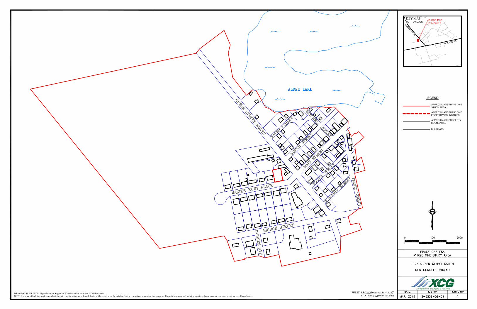
PHASE TWO CONCEPTUAL SITE MODEL A Conceptual Site Model (CSM) was prepared during the Phase One Environmental Site Assessment (ESA). The Phase One ESA included the identification of the Phase One Study Area which included properties within a 250-metre radius of the Phase One Property. The Phase One Study Area including property boundaries, roadways, and buildings is shown on Figure 1. The Phase Two Property is currently vacant with no structures on-site. The Phase Two Property details are shown on Figure 2. The land use and occupants on the adjacent neighbouring properties to the Phase Two Property are also shown on Figure 2.
The Phase Two Property is generally flat with a slight slope downward to the south toward Walter Kurt Place. The Phase Two Property is at a similar grade with its neighbouring properties. The Phase Two Property currently has no on-site structures and the ground surface is landscaped Potential Contaminating Activities Based on information provided during the Phase One ESA, historically the Phase Two Property was agricultural land before it was a vacant grassed lot. No potentially contaminating activities (PCAs) were identified on the Phase One Property. There were four properties identified as having PCAs within the Phase One Study Area. The PCAs identified on the properties within the Phase One Study Area were #10 Commercial Autobody Shops, #28 Gasoline and Associated Products Storage in Fixed Tanks, #33 Metal Treating, Coating, Plating and Finishing, #34 Metal Fabrication, and #52 Storage, Maintenance, Fuelling and Repair of Equipment, Vehicles and Material Used to Maintain Transportation Systems. The PCAs identified in the Phase One Study Area are shown on Figure 3 and listed below in Table 1. Table 1 Summary of PCAs at the Phase One Property
Address Location PCA Evaluation as an APEC 1192 Queen Street North
Adjacent to the northeast of the Phase One Property
#10 Commercial Autobody Shops #28 Gasoline and Associated Products Storage in Fixed Tanks #52 Storage, Maintenance, Fuelling and Repair of Equipment, Vehicles and Material Used to Maintain Transportation Systems
Yes, based on the proximity to the Phase One Property.
Northern portion of 1198 Queen Street North
Adjacent to the northwest of the Phase One Property
#28 Gasoline and Associated Products Storage in Fixed Tanks
No, due to the location down gradient of the inferred groundwater flow direction and historical subsurface investigations.
1206 Queen Street North
Approximately 40 m north of the Phase One Property
#33 Metal Treating, Coating, Plating and Finishing #34 Metal Fabrication
No, due to the location down gradient of the inferred groundwater flow direction.
63 Benjamin Street
Approximately 185 metres southeast of the Phase One Property
#28 Gasoline and Associated Products Storage in Fixed Tanks
No, due to separation distance from the Phase One Property and location at a lower topographical elevation.
Areas of Potential Concern The Phase One ESA identified one area of potential concern (APEC) on the Phase Two Property. The APEC identified for the Phase Two Property results from the PCAs in the Phase One Study Area. APEC1 is related to from historical activities on the adjacent property to the
5-3538-02-01/RSC535380201001Att 7.docx

South Portion of 1198 Queen Street North, New Dundee, Ontario
ATTACHMENTS
northeast (10 Commercial Autobody Shops, #28 Gasoline and Associated Products Storage in Fixed Tanks, and #52 Storage, Maintenance, Fuelling and Repair of Equipment, Vehicles and Material Used to Maintain Transportation Systems).
The APEC identified at the Phase Two Property and the contaminants of concern related to this APEC are listed in Table 2. The APEC identified at the Phase Two Property is also shown on Figure 4. Table 2 Summary of Areas of Potential Environmental Concern
APEC Identifier
Location of APEC on Phase One Property
Potentially Contaminating
Activity
Location of PCA (on-site or off-site)
Contaminants of Potential
Concern
Media Potentially Impacted
APEC1 Throughout the entire Phase One Property, as the adjacent property to the northeast was a historic garage and gasoline service station
#10 Commercial Autobody Shops #28 Gasoline and Associated Products Storage in Fixed Tanks #52 Storage, Maintenance, Fuelling and Repair of Equipment, Vehicles and Material Used to Maintain Transportation Systems
Off-site Contaminants related to vehicle maintenance garage operations and gasoline storage in USTs: - BTEX - PHCs (F1-F4) - metals
Soil and Groundwater
Notes: 1 - Area of Potential Environmental Concern means the area on, in, or under a phase one property where one or more
contaminants are potentially present, as determined through the phase one environmental site assessment, including through;
(a) identification of past or present uses on, in, or under the phase one property; and (b) identification of potentially contaminating activity. 2 - Potentially Contaminating Activity means a use or activity set out in Column A of Table 2 of Schedule D that is
occurring or has occurred in a phase one study area 3 - When completing this column, identify all contaminants of potential concern using the Method Groups as identified
in the “Protocol for the Assessment of Properties under Part XV.1 of the Environmental Protection Act,” dated March 9, 2004, amended as of July 1, 2011, as specified below: • ABNs, PCBs, Metals, Electrical Conductivity, SAR, CPs, PAHs, As, Sb, Se, Cr (VI), 1,4-Dioxane, THMs, Na,
Hg, Dioxins/Furans, PCDDs/PCDFs, VOCs, B-HWS, Methyl Mercury, OCs, BTEX, Cl-, high pH, PHCs, Ca, Mg, CN-, low pH (some acronyms not defined)
4 - When submitting a record of site condition for filing, a copy of this table must be attached Factors Influencing Contaminant Distribution It is possible that roadways and sanitary and storm sewer lines in the vicinity of the Phase Two Property may influence the migration of shallow contaminants. It is not anticipated that other buried utilities would influence contaminant distribution and migration; as the shallowest depth to groundwater at the Phase Two Property is approximately 10 metres below ground surface (bgs).
5-3538-02-01/RSC535380201001Att 7.docx

South Portion of 1198 Queen Street North, New Dundee, Ontario
ATTACHMENTS
Overburden Geology The typically geology encountered during the Phase Two ESA generally consisted of a surface layer of topsoil, underlain by sand to a maximum depth of 1.1 metres bgs, underlain by clay to a maximum depth of 6.1 metres bgs, underlain by sandy silt to a maximum depth to 9.1 metres bgs and sand beneath that to the termination of the wells at a maximum depth of 13.4 metres bgs. Bedrock or a confining layer was not encountered during the Phase Two ESA.
Cross-section locations are shown on Figure 5. The stratigraphy encountered at the Phase Two Property is shown on cross-sections in Figures 6 and 7. The cross-sections also include the well construction details, groundwater elevations, and the measured water table depth. Hydrogeological Characteristics One overburden groundwater unit was identified during the Phase Two ESA activities. The overburden groundwater unit generally consists of layers of sand, clay, sandy silt and sand. Grain size analysis of the overburden material indicated that between 70% and 90% of soil passed through sieve #200 (<0.075mm) and between 9.3% and 30% did not pass through sieve #200 (>0.075mm). The horizontal hydraulic gradient was calculated to be 0.0054. Depth to Bedrock Bedrock was not encountered during the Phase Two ESA investigation nor previous investigations at the Phase Two Property. Based on a records reviewed during the Phase One ESA, shale bedrock was encountered at an approximate depth of 61 metres bgs, approximately 120 metres northeast of the Phase Two Property. Depth to Groundwater and Groundwater Flow Direction The groundwater table was found at depths ranging from 10.0 metres bgs to 11.2 metres bgs. The horizontal hydraulic gradient was calculated using the groundwater elevations from monitoring wells with the same screened depth ranges. Groundwater elevations were measured on October 1, 2014. Groundwater elevations and contours are shown on Figure 8. Applicability of Ontario Regulation 153/04, Section 41 or Section 43.1 Based on the information reviewed during the Phase One ESA and the results of the Phase Two ESA, the Phase Two Property is not considered environmentally sensitive, as defined in Ontario Regulation (O. Reg.) 153/04, Section 41. Based on the stratigraphy encountered during the Phase Two ESA, the Phase Two Property was not determined to be a shallow soil property or located within 30 metres of a water body, as defined in Section 43.1 of O. Reg. 153/04. Areas Where Soil Has Been Brought From Another Property Based on information reviewed during the Phase One ESA and results of the Phase Two ESA, fill was not identified at the Phase Two Property. No soil was brought to the Phase Two Property during the Phase Two ESA activities. Proposed Buildings and Structures Based on information provided during the Phase One ESA, the Phase Two Property is to be developed for residential property use. The locations of any future buildings and structures on the Phase Two Property are not currently known.
5-3538-02-01/RSC535380201001Att 7.docx

South Portion of 1198 Queen Street North, New Dundee, Ontario
ATTACHMENTS
Soil Contaminants of Concern (COCs) and Distribution During the Phase Two ESA, soil samples were selected and submitted under Chain of Custody protocols to Maxxam Analytics (Maxxam) in Mississauga, for chemical analyses of petroleum hydrocarbons (PHCs) Fractions F1 to F4 (F1-F4), benzene, toluene, ethylbenzene, xylenes (BTEX), pH, and/or metals. Based on the findings of the Phase Two ESA, no soil COCs were identified at the Phase Two Property. A summary analytical results in groundwater and soil are shown on Figure 9 and in cross-section on Figures 6 and 7. Groundwater COCs and Distribution During the Phase Two ESA, groundwater samples were selected and submitted under Chain of Custody protocols to Maxxam, for chemical analyses of PHCs (F1-F4), BTEX, and/or metals. Based on a review of the analytical results from the initial sampling event, ethylbenzene was observed to marginally exceed the applicable Ministry of the Environment and Climate Change (MOECC)1 Table 2 SCS at MW3. This sampling location is located adjacent to the Walter Kurt Place roadway with vehicular traffic. As no field evidence of impacts were identified during the Phase Two ESA field activities, this results was interpreted to be anomalous. Two additional groundwater sampling events were completed at this monitoring well location (MW3) on October 17, 2014 and October 31, 2014 to verify the initial result. The subsequent groundwater sampling analytical results indicated that all analyzed parameters (including ethylbenzene) were either below the laboratory RDL or MOECC Table 2 SCS. The analytical results of the subsequent groundwater sampling events are considered to be representative of conditions at the Phase Two Property. Therefore, no groundwater COCs were identified at the Phase Two Property. A summary analytical results in groundwater and soil are shown on Figure 9 and in cross-section on Figures 6 and 7. Exposure Pathways, Release Mechanisms, and Receptors The Human Health and Ecological Conceptual Site Models are shown on Figures 10 and 11, respectively. There are no current contaminant sources or release mechanisms present on the Phase Two Property. As no COCs were identified in groundwater at the Phase Two Property, release mechanisms, transport pathways, human and ecological receptors, receptor exposure points, and routes of exposure are all incomplete. Groundwater at the Phase Two Property is not used as a potable or industrial source of water.
1 Previously also known as the Ministry of the Environment (MOE) and the Ministry of the Environment and Energy (MOEE).
5-3538-02-01/RSC535380201001Att 7.docx

South Portion of 1198 Queen Street North, New Dundee, Ontario
ATTACHMENTS
FIGURES
5-3538-02-01/RSC535380201001Att 7.docx


RESIDENTIAL
(18 WALTER
KURT PL.)
(30 WALTER
KURT PL.)
(40 WALTER
KURT PL.)
RITZ TECHNOLOGIES INC.
(1206 QUEEN ST. N.)
FORMER HOWLING GARAGE
(1192 QUEEN ST. N.)
STORAGE SHED
(1191 QUEEN ST. N.)
LIBRARY
(FORMER TD BANK)
(1176 QUEEN ST. N.)
(15 WALTER
KURT PL.)
(25 WALTER
KURT PL.)
RESIDENTIAL
(1198 QUEEN ST. N.)
R
E
S
ID
E
N
T
IA
L
R
E
S
ID
E
N
T
IA
L
MULTI-TENANT
COMMERCIAL
(1166 QUEEN ST. N.)
(12 MAIN ST.)
R
E
S
I
D
E
N
T
I
A
L
ST. JAMES
LUTHERAN CHURCH
(1177 QUEEN ST. N.)
B
R
ID
G
E
S
T
.
Q
U
E
E
N
S
T
.
N
.
DRAWING REFERENCE: Figure based on Region of Waterloo online maps and XCG field notes.NOTE: Location of building, underground utilities, etc. are for reference only and should not be relied upon for detailed design, renovation, or construction purposes. Property boundary and building locations shown may not represent actual surveyed boundaries. FILE: RSC535380201001.dwg
0 20m10
SHEET: RSC535380201001Att7-04.pdf
LEGEND:
APPROXIMATE PROPERTY
BOUNDARIES
GRASSED AREA
FENCELINE
KEY MAPNOT TO SCALE
BUILDINGS
PHASE TWO
PROPERTY
APPROXIMATE PHASE ONE
PROPERTY BOUNDARIES
AREA OF POTENTIAL
ENVIRONMENTAL CONCERN


South Portion of 1198 Queen Street North, New Dundee, Ontario
Figure 10 Human Health Conceptual Site Model
Sources Residency Media Exposure Routes Potential Human Receptors
SoilsOn-Site Off-Site
Resident - AdultResident - ChildrenWorkers (Construction/Remediation)Workers (Long-term)Workers (Repetitive Short-term)
No Impacted Soil Property Visitors - RecreationalProperty Visitors - Trespassers
Wind ErosionResident - AdultResident - ChildrenWorkers (Construction/Remediation)Workers (Long-term)Workers (Repetitive Short-term)Property Visitors - RecreationalProperty Visitors - Trespassers
VolatilizationResident - AdultResident - ChildrenWorkers (Construction/Remediation)Workers (Long-term)Workers (Repetitive Short-term)Property Visitors - RecreationalProperty Visitors - Trespassers
Groundwater
Resident - AdultResident - ChildrenWorkers (Construction/Remediation)Workers (Long-term)Workers (Repetitive Short-term)
No Impacted Groundwater Property Visitors - RecreationalProperty Visitors - Trespassers
VolatilizationResident - AdultResident - ChildrenWorkers (Construction/Remediation)Workers (Long-term)Workers (Repetitive Short-term)Property Visitors - RecreationalProperty Visitors - Trespassers
Surface Water (Not Applicable)
Resident - AdultResident - ChildrenWorkers (Construction/Remediation)Workers (Long-term)Workers (Repetitive Short-term)Property Visitors - RecreationalProperty Visitors - Trespassers
LEGEND
Inhalation
Ingestion / Dermal ContactOn-site Soils
Complete Pathway Incomplete Pathway
Ingestion /Dermal Contact
Inhalation
Ingestion /Dermal Contact
Indoor / Outdoor Air Inhalation
Leac
hing
toG
roun
dwat
er
Surface Water Surface Water
On-site / Off-site Particulate Matter
On-site / Off-site Groundwater
Impacted Soils
ImpactedGroundwater
Mig
ratio
n to
Surf
ace
Wat
er
Indoor / Outdoor Air

South Portion of 1198 Queen Street North, New Dundee, Ontario
Pre-Submission Form
Figure 11 Ecological Conceptual Site Model
Sources Residency Media Exposure Routes Potential Ecological Receptors
Soils
Soil Invertebrates CropsMammals Trees/ShrubsBirds GrassReptiles/Amphibians
Soil InvertebratesMammals
No Impacted Soil BirdsReptiles/Amphibians
Soil InvertebratesMammalsBirdsReptiles/Amphibians
Soil Invertebrates CropsMammals Trees/ShrubsBirds GrassReptiles/Amphibians
Soil Invertebrates CropsMammals Trees/ShrubsBirds GrassReptiles/Amphibians
Groundwater
CropsTrees/Shrubs
No Impacted Groundwater GrassBirds/Mammals CropsInvertebrates Trees/Shrubs
Grass
Migration off site
CropsTrees/ShrubsGrass
Birds/Mammals CropsInvertebrates Trees/Shrubs
Grass
Surface Water (Not Applicable)
LEGEND
Stem / Foliar Uptake
Prey / Food Ingestion
Dermal Contact
Complete Pathway Incomplete Pathway
Root Uptake
Gill Uptake
Surface Water Surface Water Water Ingestion
On-site Groundwater Root Uptake
Mig
ratio
n to
Surf
ace
Wat
er
Volatilization
Off-site Groundwater
Impacted Soils On-site Soils Ingestion
Root Uptake
Volatilization
Terrestrial Animals Terrestrial Plants Aquatic Animals
Aquatic Plants
Dermal Contact / Root Uptake
Leac
hing
toG
roun
dwat
er
Prey / Food Ingestion
Foliar Deposition
Inhalation/Uptake Via Volatilization
ImpactedGroundwater