south asia research initiative (sari) - welcome to...
TRANSCRIPT
South Asia Research Initiative (SARI)Updates & Next Steps
Rama NemaniNASA AMES Research Center
and
Krishna Prasad VadrevuUniversity of Maryland College Park
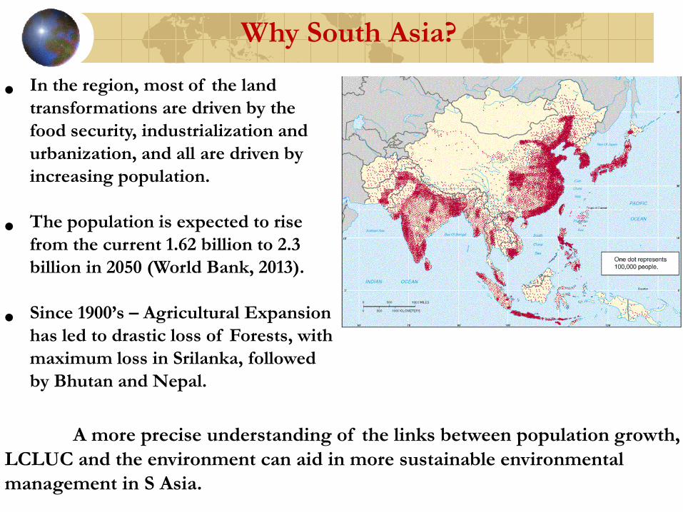
Why South Asia?
• In the region, most of the land transformations are driven by the food security, industrialization and urbanization, and all are driven by increasing population.
• The population is expected to rise from the current 1.62 billion to 2.3 billion in 2050 (World Bank, 2013).
• Since 1900’s – Agricultural Expansion has led to drastic loss of Forests, with maximum loss in Srilanka, followed by Bhutan and Nepal.
A more precise understanding of the links between population growth, LCLUC and the environment can aid in more sustainable environmental management in S Asia.

SARI - Goal
To develop an innovative research, education, and capacity building program involving state-of-the-art remote sensing, natural sciences, engineering and social sciences to enrich LCLUC science in South Asia.

To strengthen the theoretical underpinnings of LCLUC science in the South Asia region, SARI will facilitate:
• Creation of new partnerships with space agencies, universities and non-government organizations;
• Development of integrated methodologies for regional
scale LCLUC products and data sharing mechanisms,
• Programs for leadership training and experience,
• International workshops to identify regional priorities, conducting capacity building programs, and
• International student/researcher exchanges.
Objectives

Need for SARI came from local scientists
Jan-10-13th, 2013-Regional Science Meeting, Coimbatore
Total participants =120US – 18 researchers
Nepal-3; Srilanka-2; Myanmar-1; Afghanistan, Myanmar, Bangladesh-1 eachPakistan, China invited but could not attend – Visa issues
India – University Researchers, Government, Non-Government, NGO’s

Earth Observations Data and Products
- In India, a wealth of satellite data is available for LCLUC and environmental studies. Other countries yet to develop such capabilities.
- In contrast to other countries in South Asia, data access seems to be improving in India; however, lot needs to be done.
- Free access to raw data (not pdf files or JPEG maps) seems highly challenging. Example. forest maps in India!
- Most of the south Asia researchers seems to be using global products (GPP, NPP, burnt areas, any of the ECV’s), as local products are lacking. There is a strong need for local products.
- Expertise/technical know-how and latest processing methods useful to create science based products seems highly clustered.
- Inter-agency cooperation seems limited.

Earth Observations Data/Products(what is needed)
- Data sharing a major issue! Coordinated policy efforts are needed to resolve this issue!
- International cooperation between NASA, ISRO, and other space agencies in the region is needed to secure satellite data continuity and to increaseeffective dissemination of data!
- Capacity building is needed in geospatial and web-based technologies to address regional issues.
- Development of spatial tools using free and open-source software for geospatial applications shows promise for addressing LCLUC issues.
- Collaborative research can help building strong science.

• Strong sense of collaboration among South Asian scientists with US scientists;
• Highly diverse ecosystems/land cover types in South Asia for building case studies and underpinning LCLUC science;
• Presence of education and research organizations with focus on space research, forests agriculture, urban, water management, climate, atmospheric sciences, etc.
• Easy to communicate in English with researchers, students, and local people;
• Dedicated student support from Universities;
• High computer literacy;
• Relatively safe working environment in some of the Asian countries;
• High cost-to-benefit ratio due to high dollar value.
Research Strengths in SA

SARI – Facilitator and Catalyst for LCLUC Research in Asia
SARI
Identify Priority Areas in LCLUC
Promote NASA and
other Satellite RS products
Provide forum for
exchange of scientific
ideas
Synthesize information on LCLUC science
Build observational Networks
to build LCLUC
science
Facilitate capacity
building and training activities

• Phase-II – Science Planning Organizing regional workshop to bring researchers together
• Phase-III – Implementation
• Phase-I – Concept Development
Developing a white paper
SARI in motion

Phase I Concept Development
• Organizational committee with Co-leads and Task Force members formed
• SARI Formulation Leads: Rama Nemani and Krishna Vadrevu
• Task-force leads: Ruth DeFries, Thenkabail Prasad, Karen Seto, Dan Brown, and Ivan Csiszar
• Regional leads: In progress
Fig. 10
White paper prepared highlighting the need for SARI and Action Plan – to be submitted to NASA LCLUC program.

LCLUC as related to • Urbanization
• Land-Atmospheric Interactions
• Forests
• Extreme events
• Climate change
• Agriculture and Food production
Phase-II – Science Planning (many themes to choose from)

• South Asia has 14% of global cropland and 34% of global irrigated lands.
• Croplands in the region are have been decreasing rapidly due to increasing urbanization and industrialization.
• To meet the demands of the growing population, more than 80% of the increase in production will have to come from yield increase, since there is very little scope for expansion of agricultural lands.
Agricultural LCLUC
• Increasing extreme events are negatively affecting agricultural production
Understanding cropland changes and the impact of intensive agricultural practices on ecosystem services requires integrated approaches.

Agriculture, economy and the environment

Declining winds

Declining solar radiation at the surface

Declining evaporation rates

Irrigation expansion impacting climate
Groundwater Changes in peak monsoon

• Indian Council of Agricultural Research (ICAR)Land use planningFood production systems
• Indian Institute of Tropical Meteorology (IITM)Climate-Aerosol interactionsClimate variability and trends
• Indian Institute of Science (IISc)Climate modelingWater resourcesEcosystem servicesAerosol observations
• National Remote Sensing Center (NRSC)Land use mappingSatellite observations
Interest from regional players

• Complete the whitepaper with feedback from this meeting.
Next Steps
• Engage partners outside India
• Formulate 2-3 science questions related agriculture
Data/methods for studying LCLUCLand-atmosphere interactions (regional)Land use and water resources (local)
• Plan for a workshop.