reference station networks: beyond surveying. shm ... · reference station networks: beyond...
TRANSCRIPT

Reference Station Networks: Beyond Surveying."
SHMSHM
Structural Health MonitoringStructural Health Monitoring
Managing the nations' bridge infrastructureManaging the nations' bridge infrastructure
Advance technology for safety, productivity, and low costsAdvance technology for safety, productivity, and low costs
James Stowell
CGSIC 49th Meeting Savannah Georgia
•Data Acquisition Systems for Demanding Environments
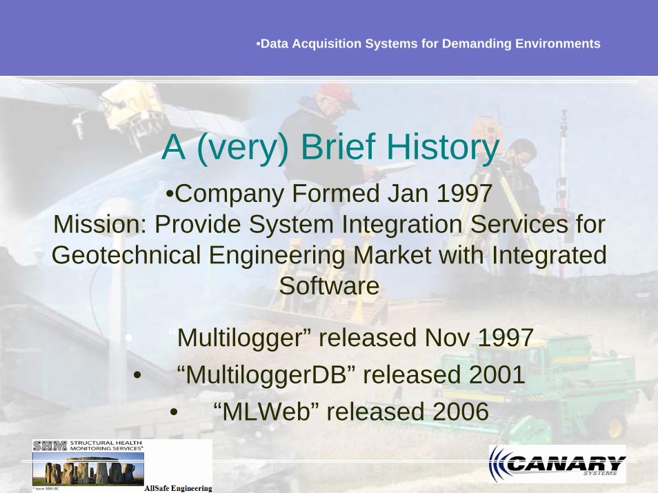
• “Multilogger” released Nov 1997• “MultiloggerDB” released 2001
• “MLWeb” released 2006
A (very) Brief History•Company Formed Jan 1997
Mission: Provide System Integration Services for Geotechnical Engineering Market with Integrated
Software

•Data Acquisition Systems for Demanding Environments
•75 Newport Road, Suite 211 New London, NH USA Phone: 603-526-9800 Fax: 603-526-9004 Email: [email protected] Web: www.canarysystems.com
• Building Campbell/Data Based Systems• Developing Hardware Peripherals (control box)• Developing Integrated Software (GPS/TPS/IPS)• Connect over 800+ instruments “simultaneously”
and alarming
What Are We Doing?

•Data Acquisition Systems for Demanding Environments
Customers
Software: MultiLogger licenses 750+ (customers)
Hardware: Managing 3000 MCU’s, (box Controller)
Top 100 hundred Engineering Companies World Wide

•Data Acquisition Systems for Demanding Environments
•75 Newport Road, Suite 211 New London, NH USA Phone: 603-526-9800 Fax: 603-526-9004 Email: [email protected] Web: www.canarysystems.com
Who Are We Doing It For?• Government – USACE/ USA
• Consulting Engineering Firms
• Engineering Companies/ URS/ ARCADIS
• Utilities - TVA/PG&E/etc.
• State DOTs

y = 5E-07x - 0.0833
time
1 hour
GPSIPS TPS
Map Coordinates

Canary Connections
• Same instrumentsGPSTPSIPS (inclinometers)Weather stations
+ over 100 different types of Geotechnical Instruments
“Bridging the Gap Geodesy to Civil Engineering”

Data Acquisition Systems for Demanding Environments
•75 Newport Road, Suite 211 New London, NH USA Phone: 603-526-9800 Fax: 603-526-9004 Email: [email protected] Web: www.canarysystems.com
Chickamauga Lock Project ExampleInstrumentation Includes (approximately):
• (44) Vibrating Wire Crackmeters
• (128) Vibrating Wire Extensometers
• (30) Vibrating Wire Growthmeters
• (180) Vibrating Wire Inclinometers and Tiltmeters
• (10) Vibrating Wire Jointmeters
• (12) Applied Geomechanics Tiltmeters
• (44) Vibrating Wire Piezometers and Uplift Cells
• (135) Vibrating Wire Stressmeters
• (258) Vibrating Wire Overcore Stress Cells
• (10) RXTX Optical Pendulums
• (13) CR10X & CR1000 Based Monitoring Systems
• (2) VW Comm Module Wireless Vibrating Wire Systems
• (1) Leica TCRP1201 Total Station with 20 Circular Prisms and 2 Reference Prisms
• (24) Manually Recorded Survey Markers
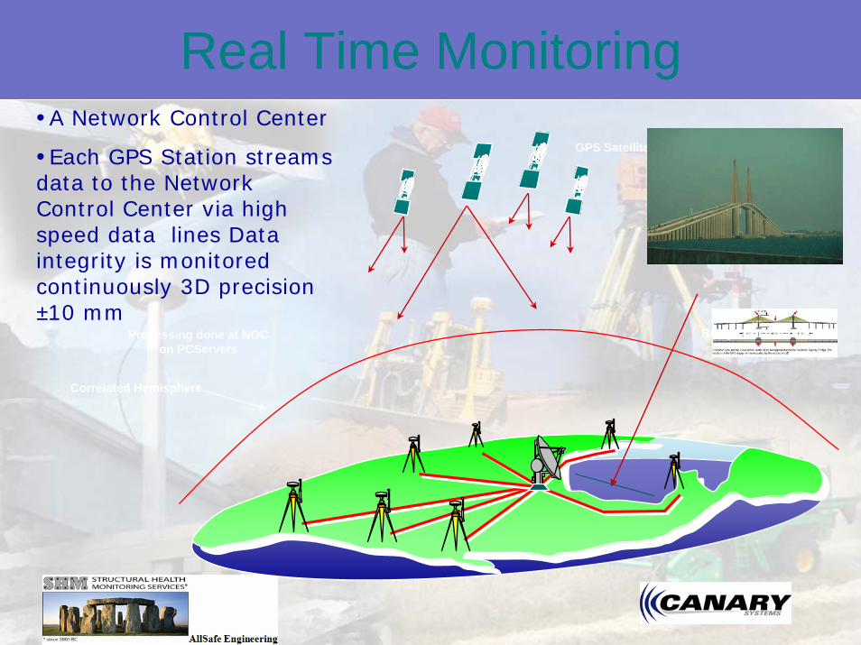
•A Network Control Center
•Each GPS Station streams data to the Network Control Center via high speed data lines Data integrity is monitored continuously 3D precision ±10 mm
Real Time MonitoringGPS Satellites
Bridge or structure
Correlated Hemisphere
Spaced based Triangulation
Processing done at NOC on PCServers

Data Sample
• Multiple structures per interface
• Selectable sensors• Dynamic graphing
based on date range desire
• Alarms by sensor• Custom data display
at sensor, structure, or structures levels

Real Time results unfiltered and resulting from a maximum displacement of 4 cm.

Reference Station Networks
• Perfect environment
• Perfect Tool
• WYSWYG
• Perfect Opportunity
•Yeah baby, we have been waiting a long time!

Structural Health Monitoring
• Start with a “GPS/IPS”(inclinometer positioning system) sensor system to clarify initial structural health concerns
• Additional sensor types can then be strategically added in suspect locations
• Structural engineers, using state-of-the-art analytics, can develop a final diagnosis quickly and efficiently with information from our sensor systems
• A definitive diagnosis leads to development of structure specific remedies and optimized Asset Management programs

Wikipedia

Monitoring ApplicationsTunnelling and Buildings
Construction site near by the tunnelDeformation risk in bad soilUrban areasMultiple total stations neededGNSS used for reference point stabilityGeotechnical sensors Railways and Highways ConstructionMaintenance of structures


•Dulles

Monitoring ApplicationsDams and Landslide
Safety and risk management of important transport links and urban areasLandslide areas near by damGlacier above water reservoir
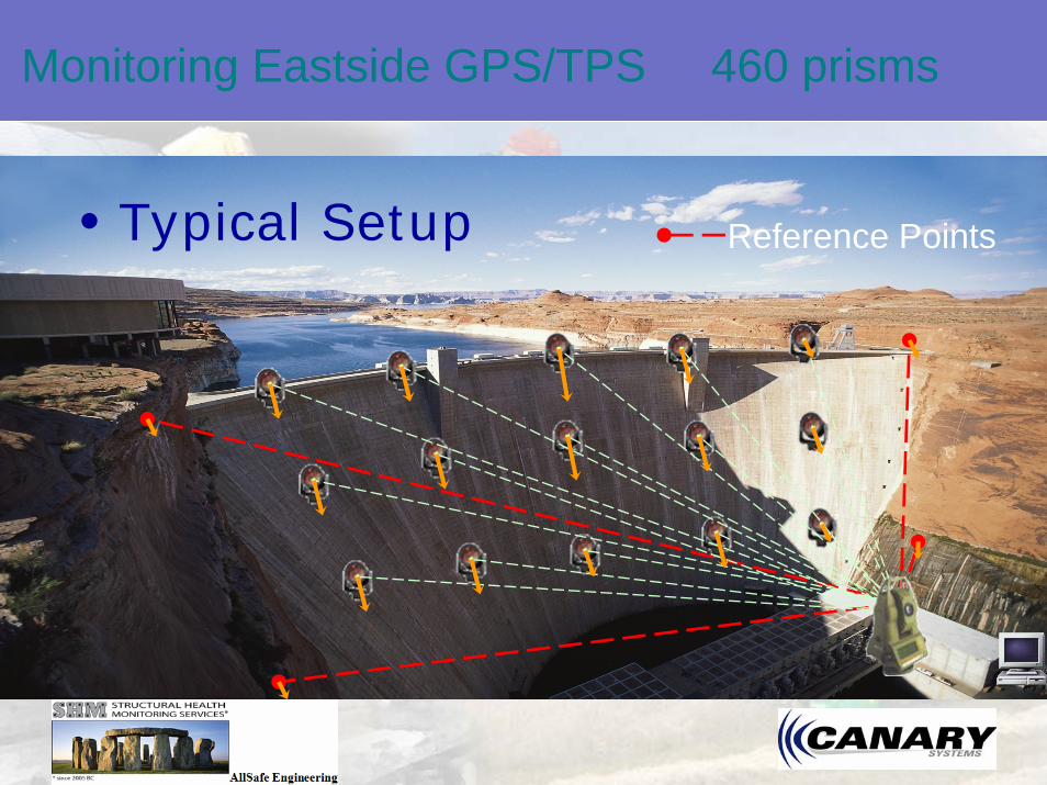
Monitoring Eastside GPS/TPS 460 prisms
•Typical Setup Reference Points

Monitoring
•Typical Setup Reference Points
Critical Zone ?Critical Zone ?
GPS
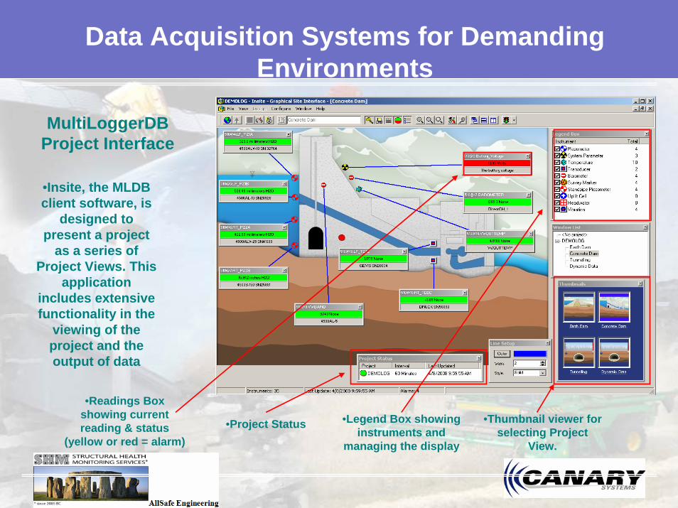
MultiLoggerDB Project Interface
•Insite, the MLDB client software, is
designed to present a project
as a series of Project Views. This
application includes extensive functionality in the
viewing of the project and the output of data
•Readings Box showing current reading & status
(yellow or red = alarm)
•Legend Box showing instruments and
managing the display
•Thumbnail viewer for selecting Project
View.
Data Acquisition Systems for Demanding Environments
•Project Status
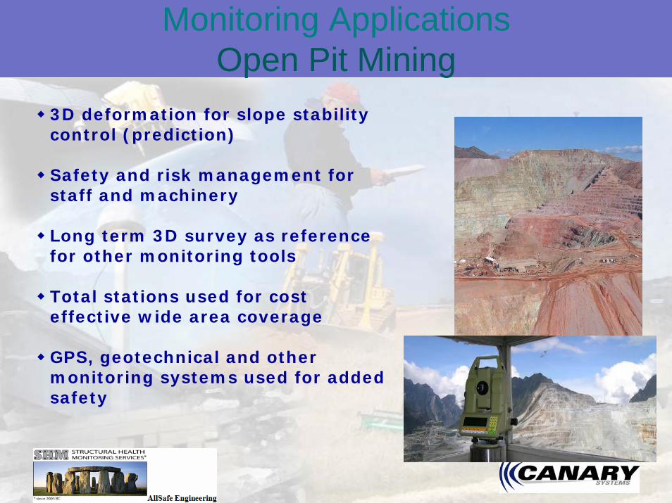
Monitoring ApplicationsOpen Pit Mining
3D deformation for slope stability control (prediction)
Safety and risk management for staff and machinery
Long term 3D survey as reference for other monitoring tools
Total stations used for cost effective wide area coverage
GPS, geotechnical and other monitoring systems used for added safety

Example – Mine
•Before
•After

Example – Mine
••First signs of First signs of movementmovement
••Second signs Second signs of movementof movement
••Danger signsDanger signs
••Crack VisibleCrack Visible
••Action takenAction taken
••Move workersMove workers
•Movement detected 2 weeks before visible Crack

•Data Acquisition Systems for Demanding Environments
•75 Newport Road, Suite 211 New London, NH USA Phone: 603-526-9800 Fax: 603-526-9004 Email: [email protected] Web: www.canarysystems.com
Morenci – Total Stations

Monitoring ApplicationsSeismic and Subsidence
Measurement of tectonic movement, earthquakes, isostatic rebound, glacial flow, subsidence due to extraction of groundwater or mining
1D or 3D deformation for understanding risks to infrastructure and for scientific study
Measurement of movements over wide areas
Often use a combination of GNSS and geotechnical instrumentation

Monitoring ApplicationsBridges and Structures
Safety and risk management of important transport links and urban areas
Construction near by buildings (high rise buildings)
Maintenance of Structures
Insurance and Bonds

IPS Inclinometer Positioning System
Continuous Beam Deflection Monitoring Using Precise
Inclinometer Data

Integrated Monitoring System
•Ground Map coordinates
•Traditionally a laser beam coupled with a ZNL is used to materialize the
main verticale.
•The observed deviations are reported on the map
coordinates.
•GPS•TPS•IPS


External Recognition of Technology GPS World Magazine
Feature Article and Cover
Sept 2003
How did we get there?
BRIDGES Magazine Feature Article and Cover
April 2006
Structural health monitoring using GPS
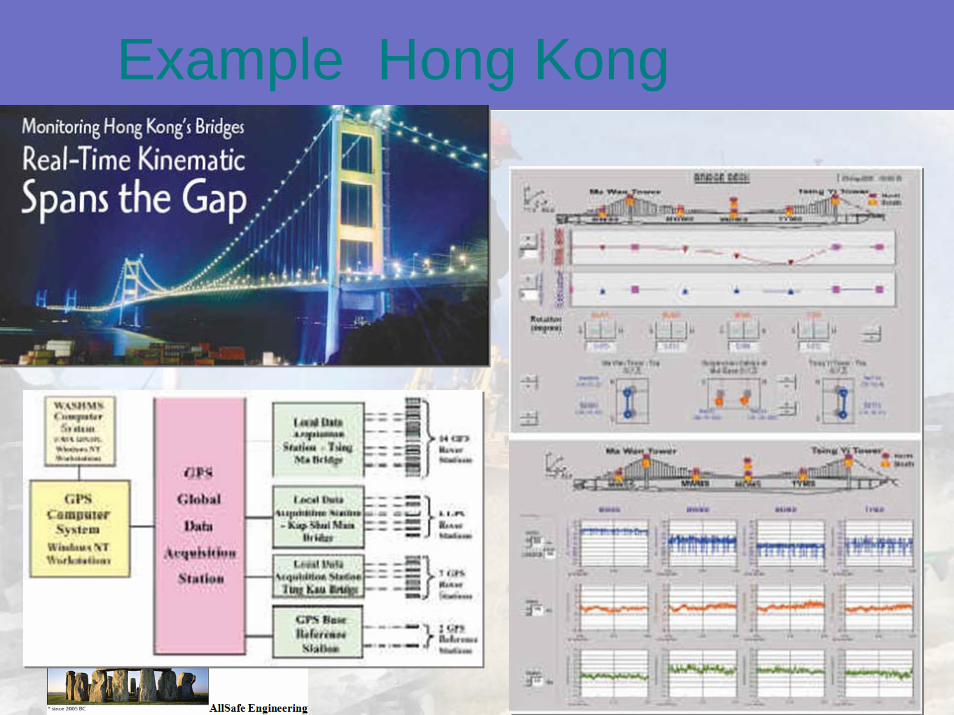
Example Hong Kong

2009 ASCE Report Card for America’s Infrastructure
Almost 27%, or more than one in four, of the nation’s bridges are considered structurally deficient or functionally obsolete. In real numbers, this means that of the 600,905 bridges listed by the U.S. Department of Transportation inDecember 2008, 72,868 (12.1%) were categorized as structurally deficientand 89,024 (14.8%) were categorized as functionally obsolete. Even thoughthe number of deficient rural bridges declined by 8596 from 2005 to 2008,the number of deficient urban bridges increased by 2817 during the same time period. Considering the higher level of passenger and freight traffic on these urban bridges, the impact is significant.
•72,868 (12.1%) structurally deficient•89,024 (14.8%) were categorized as functionally obsolete.
•One in four, (1/4) count your bridges every 4th one could fail.

WHY?


Real-Time Data Series


Diurnal effects

Jeanne
4 Hurricanes…….Structure Impact?

FLORIDA BLOWS!


Crossing tracks of Frances, Jeanne, Charley
Skyway

Hurricane Frances
Skyway
CNTR

Hurricane JeanneCNTR

Hurricane Jeanne


Conclusions Close“Refernece Stations have allowed this technology to enhanced
tremendously.”Objective and quantitative information on exact structural asset condition and management- increase life cycle
Reduced costs, delays, and risks in maintaining its Building/ Bridge infrastructure- Safety enhanced
Improved use of cash and capital resources from making “just-in-time” repairs and replacement
Enhanced maintenance practices “objective criteria” instead of subjectiveValued 24/7 health Monitoring Solutions
Higher accuracy and Precision

•Educate•Solicit
•Influence•Show off your work
Funding?How to influence people and get money

New Instruments
• TPS1 second/ remote
• Visual TargetingReflectorless
• Reduced prisms• Coaxial optics• Reduces risk• remote
• Visual ScanningExceed Tolerance
• Automatic Scanning – Course 10 x 10– Fine 1 x 1
3 in 1 1. TPS2. Scanner3. Coaxial Camera

•Ask yourself
•Are you ready for a failure?
Question

Thank you
www.canarysystem.com