anna university, chennaicac.annauniv.edu/phpproject1/uddetails/udug_2015/03.geo.pdfmodern surveying...
TRANSCRIPT
1
ANNA UNIVERSITY, CHENNAI
UNIVERSITY DEPARTMENTS
REGULATIONS – 2015
CHOICE BASED CREDIT SYSTEM
PROGRAMME EDUCATIONAL OBJECTIVES (PEOs) I. To prepare the students for successful careers in Geospatial Industries and Information
Technology that meet the needs of India and other Countries.
II. To develop the professional ability among the students to collect various Geospatial relates
from various platform, data, analysis and synthesis that create user oriented real world
applications.
III. To provide an opportunity for students to work as part of teams on multidisciplinary
projects.
IV. To provide students with a sound foundation in the mathematical, scientific and
engineering fundamentals necessary to formulate, solve and analyze engineering and
multidisciplinary problems and to prepare them for graduate studies.
V. To promote students awareness of the life-long learning and to introduce them to
professional ethics and codes of professional practice.
PROGRAMME OUTCOMES (POs)
a) Graduates will acquire basic knowledge in B.E (Geoinformatics) and engineering.
b) Graduates will acquire the ability to model and development of application in Geospatial arena interpret and analyze data, and report results.
c) Graduates will acquire the ability to develop Geospatial system that meets desired specifications and requirements.
d) Graduates will acquire the ability to function on engineering and science laboratory teams, as well as on multidisciplinary problem solving teams.
e) Graduates will acquire the ability to identify, formulate and solve Geomatics related problems.
f) Graduates will acquire an understanding of their professional and ethical responsibilities.
g) Graduates will be able to communicate effectively in both verbal and written forms.
h) Graduates will gain confidence to apply Geospatial techniques in global and societal contexts.
i) Graduates will be capable of self - education and clearly understand the value of lifelong learning.
j) Graduates will be broadly educated and will have an understanding of the impact of
engineering on society and demonstrate awareness of contemporary issues.
k) Graduates will be familiar with modern hardware and software tools and equipments to analyze Geospatial / Geomatics engineering problems.
B. E. GEOINFORMATICS
2
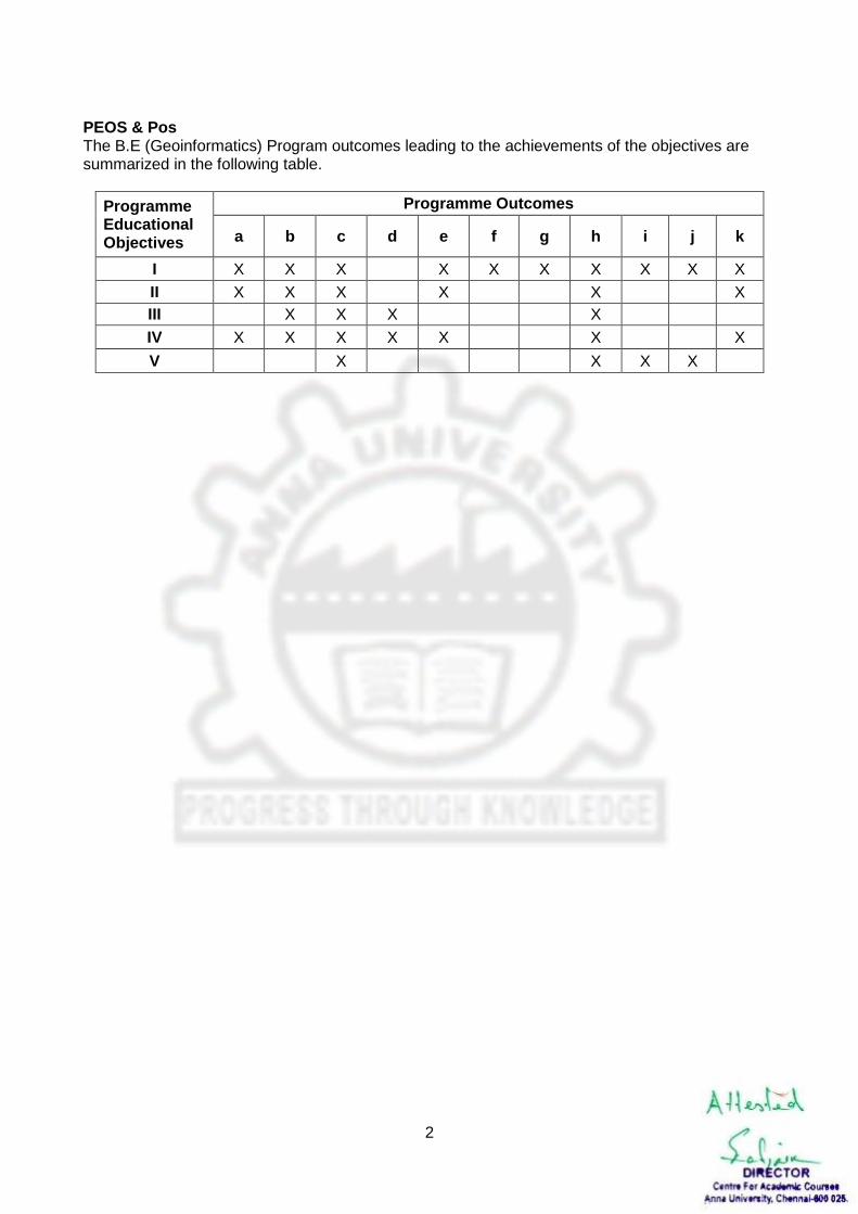
PEOS & Pos The B.E (Geoinformatics) Program outcomes leading to the achievements of the objectives are summarized in the following table.
Programme Educational Objectives
Programme Outcomes
a b c d e f g h i j k
I X X X X X X X X X X
II X X X X X X
III X X X X
IV X X X X X X X
V X X X X
3
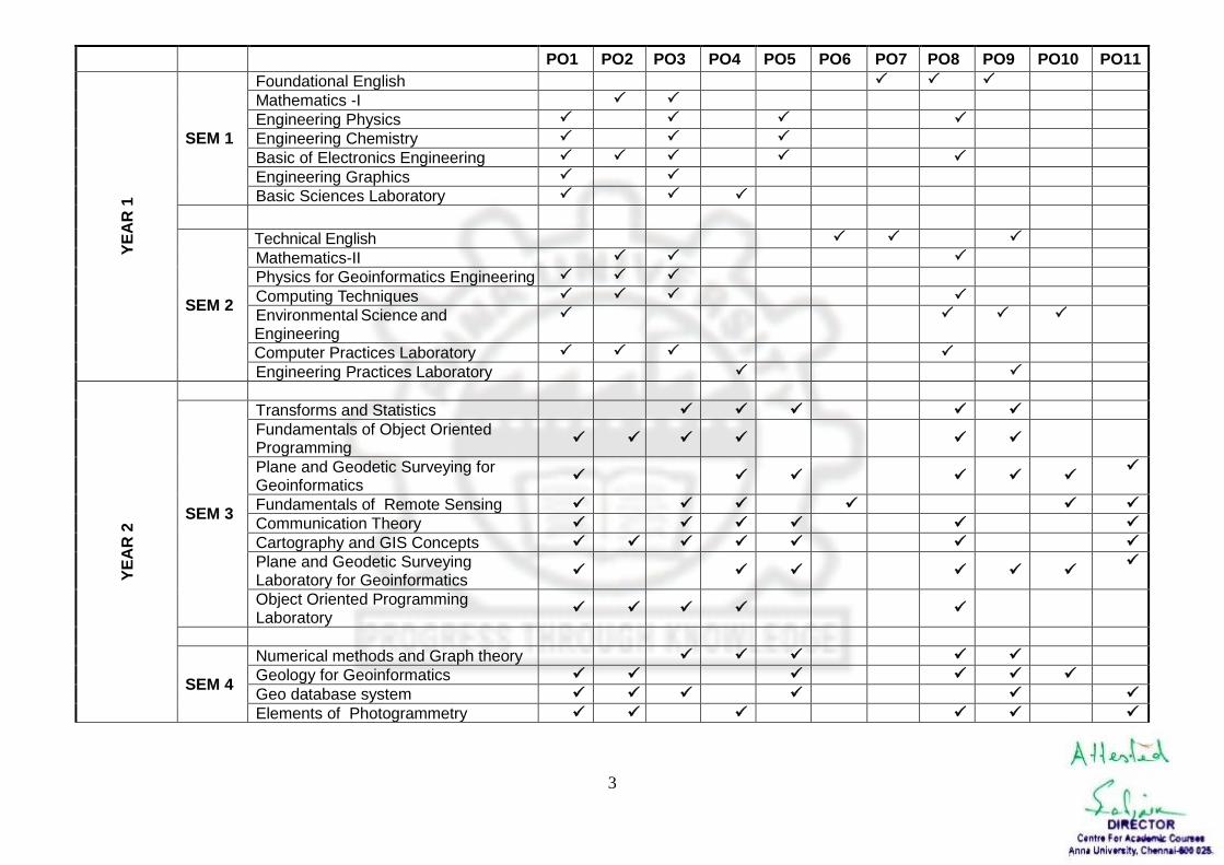
PO1 PO2 PO3 PO4 PO5 PO6 PO7 PO8 PO9 PO10 PO11
YE
AR
1
SEM 1
Foundational English
Mathematics -I
Engineering Physics
Engineering Chemistry
Basic of Electronics Engineering
Engineering Graphics
Basic Sciences Laboratory
SEM 2
Technical English
Mathematics-II
Physics for Geoinformatics Engineering
Computing Techniques
Environmental Science and Engineering
Computer Practices Laboratory
Engineering Practices Laboratory
YE
AR
2
SEM 3
Transforms and Statistics
Fundamentals of Object Oriented Programming
Plane and Geodetic Surveying for Geoinformatics
Fundamentals of Remote Sensing Communication Theory Cartography and GIS Concepts Plane and Geodetic Surveying Laboratory for Geoinformatics
Object Oriented Programming Laboratory
SEM 4
Numerical methods and Graph theory
Geology for Geoinformatics
Geo database system Elements of Photogrammetry
4
Modern Surveying
Urban Geoinformatics
Total Station and GPS Surveying Laboratory
Cartography and GIS Laboratory
YE
AR
3
SEM 5
Geodesy
Digital Image Processing for Geoinformatics Engineers
Advanced Remote Sensing
Satellite Meteorology
Professional Elective I
Professional Elective II
Geo Database Laboratory
Photogrammetry Laboratory
SEM 6
Hydrology and Water Resources Engineering for Geoinformatics
Spatial Analysis and Applications
Open Source GIS
Soft Computing Techniques
Professional Elective III
Open Elective I*
Spatial Analysis and Applications Laboratory
Digital Image Processing Laboratory
Survey Camp (2 Weeks – During V Semester)
YE
AR
4
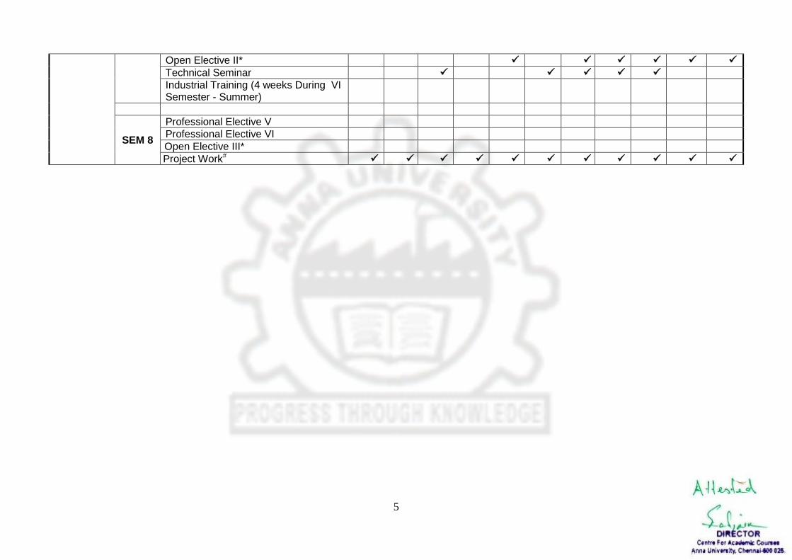
SEM 7
Decision Support System for Resource Management
Agriculture and Forestry for Geoinformatics
Employability Skills
Oceanography and Coastal Processes
Professional Elective IV
5
Open Elective II*
Technical Seminar
Industrial Training (4 weeks During VI Semester - Summer)
SEM 8
Professional Elective V
Professional Elective VI
Open Elective III*
Project Work#
6
ANNA UNIVERSITY, CHENNAI
UNIVERSITY DEPARTMENTS
REGULATIONS – 2015
CHOICE BASED CREDIT SYSTEM
CURRICULA AND SYLLABI I - VIII SEMESTERS
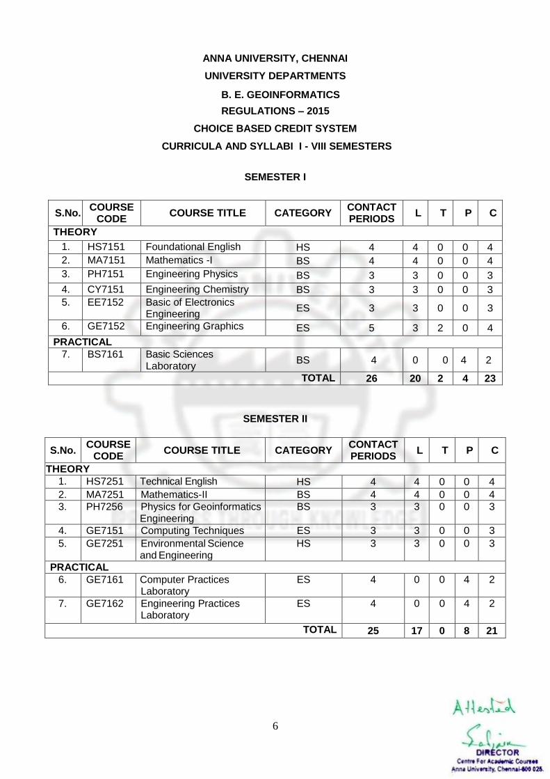
SEMESTER I
S.No. COURSE
CODE COURSE TITLE CATEGORY
CONTACT PERIODS
L T P C
THEORY
1. HS7151 Foundational English HS 4 4 0 0 4
2. MA7151 Mathematics -I BS 4 4 0 0 4
3. PH7151 Engineering Physics BS 3 3 0 0 3
4. CY7151 Engineering Chemistry BS 3 3 0 0 3
5. EE7152
Basic of Electronics Engineering
ES 3 3 0 0 3
6. GE7152 Engineering Graphics ES 5 3 2 0 4
PRACTICAL
7. BS7161 Basic Sciences Laboratory
BS 4 0 0 4 2
TOTAL 26 20 2 4 23
SEMESTER II
S.No. COURSE
CODE COURSE TITLE CATEGORY
CONTACT PERIODS
L T P C
THEORY
1. HS7251 Technical English HS 4 4 0 0 4
2. MA7251 Mathematics-II BS 4 4 0 0 4
3. PH7256 Physics for Geoinformatics Engineering
BS 3 3 0 0 3
4. GE7151 Computing Techniques ES 3 3 0 0 3
5. GE7251 Environmental Science and Engineering
HS 3 3 0 0 3
PRACTICAL
6. GE7161 Computer Practices Laboratory
ES 4 0 0 4 2
7. GE7162 Engineering Practices Laboratory
ES 4 0 0 4 2
TOTAL 25 17 0 8 21
B. E. GEOINFORMATICS
7
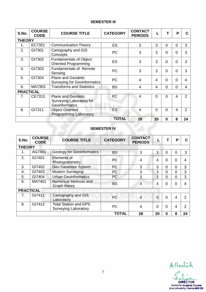
SEMESTER III
S.No. COURSE
CODE COURSE TITLE CATEGORY
CONTACT PERIODS
L T P C
THEORY
1. EC7351 Communication Theory ES 3 3 0 0 3
2. GI7301
Cartography and GIS Concepts
PC 3 3 0 0 3
3. GI7302 Fundamentals of Object Oriented Programming
ES 3 3 0 0 3
4. GI7303 Fundamentals of Remote Sensing
PC 3 3 0 0 3
5. GI7304 Plane and Geodetic Surveying for Geoinformatics
PC 4 4 0 0 4
6. MA7303 Transforms and Statistics BS 4 4 0 0 4
PRACTICAL
7. CE7313 Plane and Geodetic Surveying Laboratory for Geoinformatics
PC 4 0 0 4 2
8. GI7311 Object Oriented Programming Laboratory
ES 4 0 0 4 2
TOTAL 28 20 0 8 24
SEMESTER IV
S.No. COURSE
CODE COURSE TITLE CATEGORY
CONTACT PERIODS
L T P C
THEORY
1. AG7401 Geology for Geoinformatics BS 3 3 0 0 3
2. GI7401 Elements of Photogrammetry
PC 4 4 0 0 4
3. GI7402 Geo Database System PC 3 3 0 0 3
4. GI7403 Modern Surveying PC 3 3 0 0 3
5. GI7404 Urban Geoinformatics PC 3 3 0 0 3
6. MA7401 Numerical Methods and Graph theory
BS 4 4 0 0 4
PRACTICAL
7. GI7411 Cartography and GIS Laboratory
PC 4 0 0 4 2
8. GI7412 Total Station and GPS Surveying Laboratory
PC 4 0 0 4 2
TOTAL 28 20 0 8 24
8
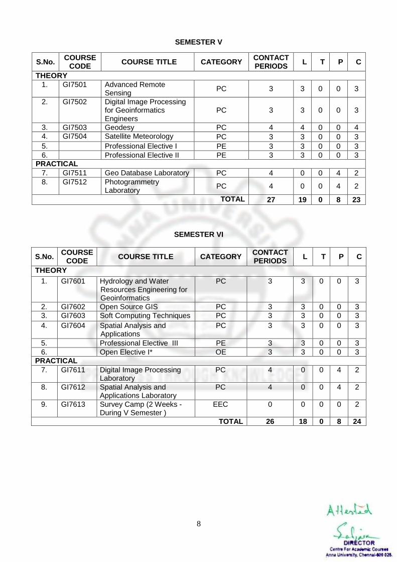
SEMESTER V
S.No. COURSE
CODE COURSE TITLE CATEGORY
CONTACT PERIODS
L T P C
THEORY
1. GI7501 Advanced Remote Sensing
PC 3 3 0 0 3
2. GI7502 Digital Image Processing for Geoinformatics Engineers
PC 3 3 0 0 3
3. GI7503 Geodesy PC 4 4 0 0 4
4. GI7504 Satellite Meteorology PC 3 3 0 0 3
5. Professional Elective I PE 3 3 0 0 3
6. Professional Elective II PE 3 3 0 0 3
PRACTICAL
7. GI7511 Geo Database Laboratory PC 4 0 0 4 2
8. GI7512 Photogrammetry Laboratory
PC 4 0 0 4 2
TOTAL 27 19 0 8 23
SEMESTER VI
S.No. COURSE
CODE COURSE TITLE CATEGORY
CONTACT PERIODS
L T P C
THEORY
1. GI7601
Hydrology and Water Resources Engineering for Geoinformatics
PC 3 3 0 0 3
2. GI7602 Open Source GIS PC 3 3 0 0 3
3. GI7603 Soft Computing Techniques PC 3 3 0 0 3
4. GI7604 Spatial Analysis and Applications
PC 3 3 0 0 3
5. Professional Elective III PE 3 3 0 0 3
6. Open Elective I* OE 3 3 0 0 3
PRACTICAL
7. GI7611 Digital Image Processing Laboratory
PC 4 0 0 4 2
8. GI7612 Spatial Analysis and Applications Laboratory
PC 4 0 0 4 2
9. GI7613 Survey Camp (2 Weeks - During V Semester )
EEC 0 0 0 0 2
TOTAL 26 18 0 8 24
9
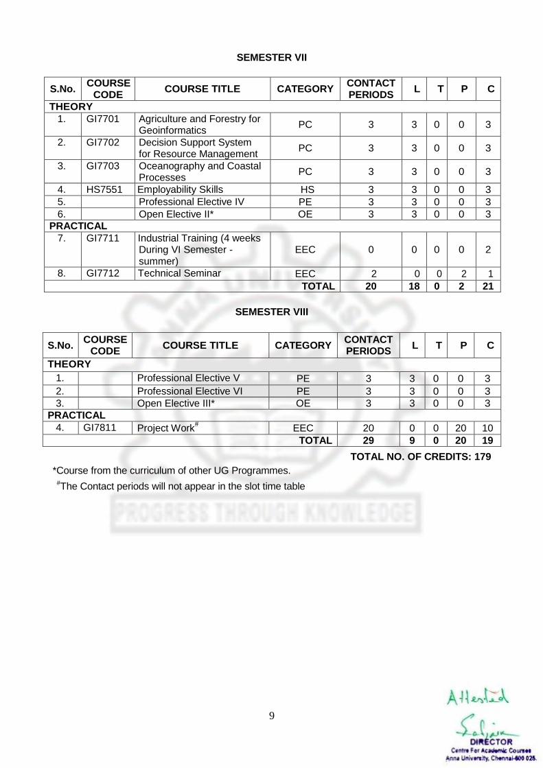
SEMESTER VII
S.No. COURSE
CODE COURSE TITLE CATEGORY
CONTACT PERIODS
L T P C
THEORY
1. GI7701 Agriculture and Forestry for Geoinformatics
PC 3 3 0 0 3
2. GI7702 Decision Support System for Resource Management
PC 3 3 0 0 3
3. GI7703 Oceanography and Coastal Processes
PC 3 3 0 0 3
4. HS7551 Employability Skills HS 3 3 0 0 3
5. Professional Elective IV PE 3 3 0 0 3
6. Open Elective II* OE 3 3 0 0 3
PRACTICAL
7. GI7711
Industrial Training (4 weeks During VI Semester - summer)
EEC 0 0 0 0 2
8. GI7712 Technical Seminar EEC 2 0 0 2 1
TOTAL 20 18 0 2 21
SEMESTER VIII
S.No. COURSE
CODE COURSE TITLE CATEGORY
CONTACT PERIODS
L T P C
THEORY
1. Professional Elective V PE 3 3 0 0 3
2. Professional Elective VI PE 3 3 0 0 3
3. Open Elective III* OE 3 3 0 0 3
PRACTICAL
4. GI7811 Project Work# EEC 20 0 0 20 10
TOTAL 29 9 0 20 19
TOTAL NO. OF CREDITS: 179
*Course from the curriculum of other UG Programmes.
#The Contact periods will not appear in the slot time table
10
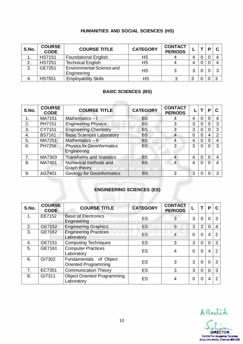
HUMANITIES AND SOCIAL SCIENCES (HS)
S.No. COURSE
CODE COURSE TITLE CATEGORY
CONTACT PERIODS
L T P C
1. HS7151 Foundational English HS 4 4 0 0 4
2. HS7251 Technical English HS 4 4 0 0 4
3. GE7251 Environmental Science and Engineering
HS 3 3 0 0 3
4. HS7551 Employability Skills HS 3 3 0 0 3
BASIC SCIENCES (BS)
S.No. COURSE
CODE COURSE TITLE CATEGORY
CONTACT PERIODS
L T P C
1. MA7151 Mathematics – I BS 4 4 0 0 4
2. PH7151 Engineering Physics BS 3 3 0 0 3
3. CY7151 Engineering Chemistry BS 3 3 0 0 3
4. BS7161 Basic Sciences Laboratory BS 4 0 0 4 2
5. MA7251 Mathematics – II BS 4 4 0 0 4
6. PH7256 Physics for Geoinformatics Engineering
BS 3 3 0 0 3
7. MA7303 Transforms and Statistics BS 4 4 0 0 4
8. MA7401
Numerical methods and Graph theory
BS 4 4 0 0 4
9. AG7401 Geology for Geoinformatics BS 3 3 0 0 3
ENGINEERING SCIENCES (ES)
S.No. COURSE
CODE COURSE TITLE CATEGORY
CONTACT PERIODS
L T P C
1. EE7152
Basic of Electronics Engineering
ES 3 3 0 0 3
2. GE7152 Engineering Graphics ES 5 3 2 0 4
3. GE7162 Engineering Practices Laboratory
ES 4 0 0 4 2
4. GE7151 Computing Techniques ES 3 3 0 0 3
5. GE7161 Computer Practices Laboratory
ES 4 0 0 4 2
6. GI7302
Fundamentals of Object Oriented Programming
ES 3 3 0 0 3
7. EC7351 Communication Theory ES 3 3 0 0 3
8. GI7311
Object Oriented Programming Laboratory
ES 4 0 0 4 2
11
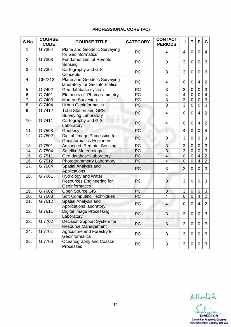
PROFESSIONAL CORE (PC)
S.No. COURSE
CODE COURSE TITLE CATEGORY
CONTACT PERIODS
L T P C
1. GI7304
Plane and Geodetic Surveying for Geoinformatics
PC 4 4 0 0 4
2. GI7303
Fundamentals of Remote Sensing
PC 3 3 0 0 3
3. GI7301
Cartography and GIS Concepts
PC 3 3 0 0 3
4. CE7313
Plane and Geodetic Surveying laboratory for Geoinformatics
PC 4 0 0 4 2
5. GI7402 Geo database system PC 3 3 0 0 3
6. GI7401 Elements of Photogrammetry PC 4 4 0 0 4
7. GI7403 Modern Surveying PC 3 3 0 0 3
8. GI7404 Urban Geoinformatics PC 3 3 0 0 3
9. GI7412 Total Station and GPS Surveying Laboratory
PC 4 0 0 4 2
10. GI7411
Cartography and GIS Laboratory
PC 4 0 0 4 2
11. GI7503 Geodesy PC 4 4 0 0 4
12. GI7502 Digital Image Processing for Geoinformatics Engineers
PC 3 3 0 0 3
13. GI7501 Advanced Remote Sensing PC 3 3 0 0 3
14. GI7504 Satellite Meteorology PC 3 3 0 0 3
15. GI7511 Geo database Laboratory PC 4 0 0 4 2
16. GI7512 Photogrammetry Laboratory PC 4 0 0 4 2
17. GI7604 Spatial Analysis and Applications
PC 3 3 0 0 3
18. GI7601 Hydrology and Water Resources Engineering for Geoinformatics
PC 3 3 0 0 3
19. GI7602 Open Source GIS PC 3 3 0 0 3
20. GI7603 Soft Computing Techniques PC 4 0 0 4 2
21. GI7612 Spatial Analysis and Applications laboratory
PC 4 0 0 4 2
22. GI7611 Digital Image Processing Laboratory
PC 3 3 0 0 3
23. GI7702 Decision Support System for Resource Management
PC 3 3 0 0 3
24. GI7701 Agriculture and Forestry for Geoinformatics
PC 3 3 0 0 3
25. GI7703 Oceanography and Coastal Processes
PC 3 3 0 0 3
12
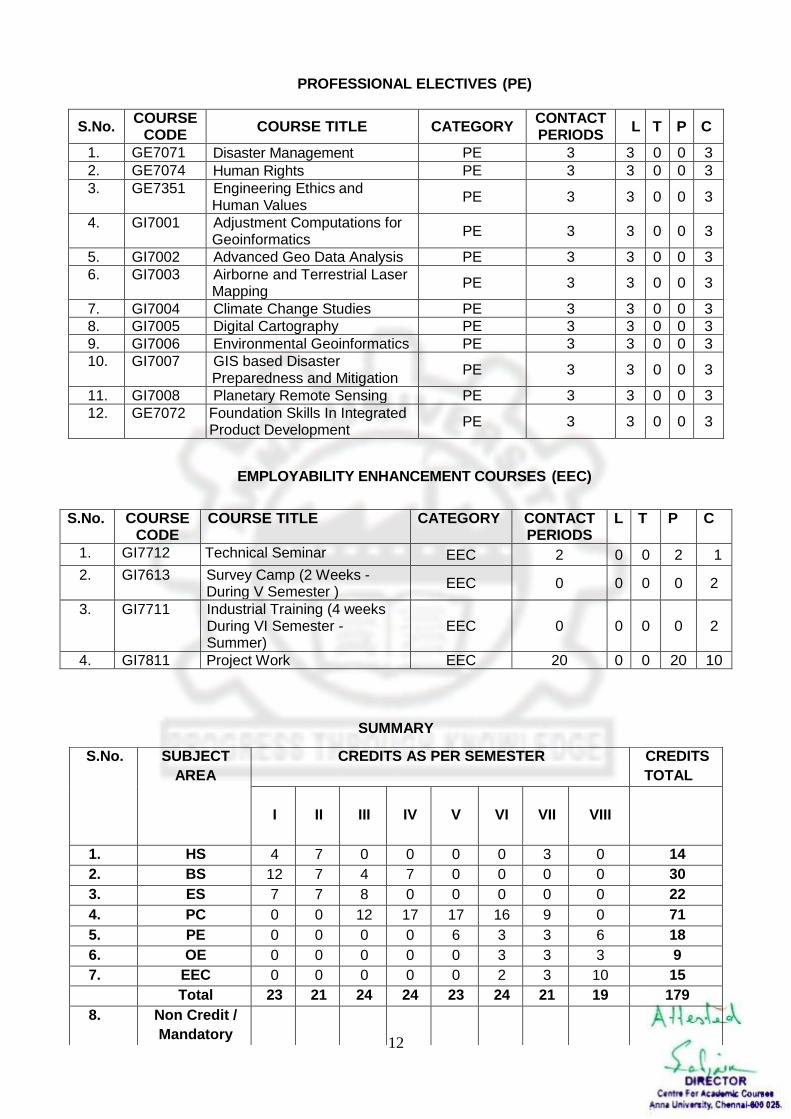
PROFESSIONAL ELECTIVES (PE)
S.No. COURSE
CODE COURSE TITLE CATEGORY
CONTACT PERIODS
L T P C
1. GE7071 Disaster Management PE 3 3 0 0 3
2. GE7074 Human Rights PE 3 3 0 0 3
3. GE7351 Engineering Ethics and Human Values
PE 3 3 0 0 3
4. GI7001 Adjustment Computations for Geoinformatics
PE 3 3 0 0 3
5. GI7002 Advanced Geo Data Analysis PE 3 3 0 0 3
6. GI7003 Airborne and Terrestrial Laser Mapping
PE 3 3 0 0 3
7. GI7004 Climate Change Studies PE 3 3 0 0 3
8. GI7005 Digital Cartography PE 3 3 0 0 3
9. GI7006 Environmental Geoinformatics PE 3 3 0 0 3
10. GI7007 GIS based Disaster Preparedness and Mitigation
PE 3 3 0 0 3
11. GI7008 Planetary Remote Sensing PE 3 3 0 0 3
12. GE7072 Foundation Skills In Integrated Product Development
PE 3 3 0 0 3
EMPLOYABILITY ENHANCEMENT COURSES (EEC)
S.No. COURSE CODE
COURSE TITLE CATEGORY CONTACT PERIODS
L T P C
1. GI7712 Technical Seminar EEC 2 0 0 2 1
2. GI7613 Survey Camp (2 Weeks - During V Semester )
EEC 0 0 0 0 2
3. GI7711 Industrial Training (4 weeks During VI Semester - Summer)
EEC 0 0 0 0 2
4. GI7811 Project Work EEC 20 0 0 20 10
SUMMARY
S.No. SUBJECT
AREA
CREDITS AS PER SEMESTER CREDITS
TOTAL
I
II III IV V VI VII VIII
1. HS 4 7 0 0 0 0 3 0 14
2. BS 12 7 4 7 0 0 0 0 30
3. ES 7 7 8 0 0 0 0 0 22
4. PC 0 0 12 17 17 16 9 0 71
5. PE 0 0 0 0 6 3 3 6 18
6. OE 0 0 0 0 0 3 3 3 9
7. EEC 0 0 0 0 0 2 3 10 15
Total 23 21 24 24 23 24 21 19 179
8. Non Credit /
Mandatory
13
HS7151 FOUNDATIONAL ENGLISH L T P C 4 0 0 4 COURSE DESCRIPTION: This course aims at developing the language skills necessary for the first year students of Engineering and Technology. OBJECTIVES:
To develop the four language skills – Listening, Speaking, Reading and Writing.
To improve the students’ communicative competence in English.
To teach students the various aspects of English language usage.
CONTENTS UNIT I GREETING AND INTRODUCING ONESELF 12 Listening- Types of listening – Listening to short talks, conversations; Speaking – Speaking about one’s place, important festivals etc. – Introducing oneself, one’s family/ friend; Reading – Skimming a passage– Scanning for specific information; Writing- Guided writing - Free writing on any given topic ( My favourite place/ Hobbies/ School life, writing about one’s leisure time activities, hometown, etc.); Grammar – Tenses (present and present continuous) -Question types - Regular and irregular verbs; Vocabulary – Synonyms and Antonyms. UNIT II GIVING INSTRUCTIONS AND DIRECTIONS 12 Listening – Listening and responding to instructions; Speaking – Telephone etiquette - Giving oral instructions/ Describing a process – Asking and answering questions; Reading – Reading and finding key information in a given text - Critical reading - Writing –Process description( non-technical)- Grammar – Tense (simple past& past continuous) - Use of imperatives – Subject – verb agreement – Active and passive voice; - Vocabulary – Compound words – Word formation – Word expansion ( root words). UNIT III READING AND UNDERSTANDING VISUAL MATERIAL 12 Listening- Listening to lectures/ talks and completing a task; Speaking –Role play/ Simulation – Group interaction; Reading – Reading and interpreting visual material; Writing- Jumbled sentences – Discourse markers and Cohesive devices – Essay writing (cause & effect/ narrative);Grammar – Tenses (perfect), Conditional clauses –Modal verbs; Vocabulary –Cause and effect words; Phrasal verbs in context. UNIT IV CRITICAL READING AND WRITING 12 Listening- Watching videos/ documentaries and responding to questions based on them; Speaking Informal and formal conversation; Reading –Critical reading (prediction & inference); Writing–Essay writing ( compare & contrast/ analytical) – Interpretation of visual materials; Grammar – Tenses (future time reference);Vocabulary – One word substitutes (with meanings) – Use of abbreviations & acronyms – Idioms in sentences. UNIT V LETTER WRITING AND SENDING E-MAILS 12 Listening- Listening to programmes/broadcast/ telecast/ podcast; Speaking – Giving impromptu talks, Making presentations on given topics- Discussion on the presentation; Reading –Extensive reading; Writing- Poster making – Letter writing (Formal and E-mail) ;Grammar – Direct and Indirect speech – Combining sentences using connectives; Vocabulary –Collocation; TEACHING METHODS: Interactive sessions for the speaking module. Use of audio – visual aids for the various listening activities. Contextual Grammar Teaching.
14
EVALUATION PATTERN: Internals – 50% End Semester – 50%
TOTAL: 60 PERIODS
OUTCOMES:
Students will improve their reading and writing skills
Students will become fluent and proficient in communicative English
Students will be able to improve their interpersonal communication
TEXTBOOK: 1. Richards, Jack.C with Jonathan Hull and Susan Proctor New Interchange : English for
International Communication. (level2, Student’s Book) Cambridge University Press, New Delhi: 2010.
REFERENCES: 1. Bailey, Stephen. Academic Writing: A practical guide for students. New York:
Rutledge,2011. 2. Morgan, David and Nicholas Regan. Take-Off: Technical English for Engineering.
London: Garnet Publishing Limited, 2008. 3. Redston, Chris & Gillies Cunningham Face2Face (Pre-intermediate Student’s Book&
Workbook) Cambridge University Press, New Delhi: 2005 4. Comfort, Jeremy, et al. Speaking Effectively : Developing Speaking Skillsfor Business
English. Cambridge University Press, Cambridge: Reprint 2011. MA7151 MATHEMATICS – I
(Common to all branches of B.E. / B.Tech. Programmes in I Semester)
L T P C 4 0 0 4
OBJECTIVES:
The goal of this course is for students to gain proficiency in calculus computations. In calculus, we use three main tools for analyzing and describing the behavior of functions: limits, derivatives, and integrals. Students will use these tools to solve application problems in a variety of settings ranging from physics and biology to business and economics.
To make the student acquire sound knowledge of techniques in solving ordinary differential equations that model engineering problems.
To familiarize the student with functions of several variables. This is needed in many branches of engineering.
To acquaint the student with mathematical tools needed in evaluating multiple integrals and their usage.
UNIT I DIFFERENTIAL CALCULUS 12 Representation of functions - New functions from old functions - Limit of a function - Limits at infinity - Continuity - Derivatives - Differentiation rules - Polar coordinate system - Differentiation in polar coordinates - Maxima and Minima of functions of one variable.
UNIT II FUNCTIONS OF SEVERAL VARIABLES 12 Partial derivatives – Homogeneous functions and Euler’s theorem – Total derivative – Differentiation of implicit functions – Change of variables – Jacobians – Partial differentiation of implicit functions – Taylor’s series for functions of two variables – Errors and approximations – Maxima and minima of functions of two variables – Lagrange’s method of undetermined
15
multipliers. UNIT III INTEGRAL CALCULUS 12 Definite and Indefinite integrals - Substitution rule - Techniques of Integration - Integration by parts, Trigonometric integrals, Trigonometric substitutions, Integration of rational functions by partial fraction, Integration of irrational functions - Improper integrals. UNIT IV MULTIPLE INTEGRALS 12 Double integrals – Change of order of integration – Double integrals in polar coordinates – Area enclosed by plane curves – Triple integrals – Volume of solids – Change of variables in double and triple integrals. UNIT V DIFFERENTIAL EQUATIONS 12 Method of variation of parameters – Method of undetermined coefficients – Homogenous equation of Euler’s and Legendre’s type – System of simultaneous linear differential equations with constant coefficients. TOTAL : 60 PERIODS OUTCOMES:
Understanding of the ideas of limits and continuity and an ability to calculate with them and apply them.
Improved facility in algebraic manipulation.
Fluency in differentiation.
Fluency in integration using standard methods, including the ability to find an appropriate method for a given integral.
Understanding the ideas of differential equations and facility in solving simple standard examples.
TEXTBOOKS:
1. James Stewart, "Calculus with Early Transcendental Functions", Cengage Learning, New Delhi, 2008.
2. Narayanan S. and Manicavachagom Pillai T. K., “Calculus" Volume I and II, S. Viswanathan Publishers Pvt. Ltd., Chennai, 2007.
3. Erwin Kreyszig, "Advanced Engineering Mathematics", John Wiley and Sons, 9th Edition, New Delhi, 2014.
4. Grewal B.S., “Higher Engineering Mathematics”, Khanna Publishers, New Delhi, 43rd Edition, 2014.
REFERENCES:
1. Ramana B.V., “Higher Engineering Mathematics”, Tata McGraw Hill Co. Ltd., New Delhi, 11th Reprint, 2010.
2. Jain R.K. and Iyengar S.R.K., “Advanced Engineering Mathematics”, Narosa Publications, New Delhi, 3rd Edition, 2007.
3. Bali N., Goyal M. and Watkins C., “Advanced Engineering Mathematics”, Firewall Media (An imprint of Lakshmi Publications Pvt., Ltd.,), New Delhi, 7th Edition, 2009.
4. Greenberg M.D., “Advanced Engineering Mathematics”, Pearson Education, New Delhi, 2nd Edition, 5th Reprint, 2009.
5. Peter V.O’Neil, “Advanced Engineering Mathematics”, Cengage Learning India Pvt., Ltd, New Delhi, 2007.
16
PH7151 ENGINEERING PHYSICS
(Common to all branches of B.E. / B.Tech. Programmes) L T P C
3 0 0 3
OBJECTIVE:
To introduce the concept and different ways to determine moduli of elasticity and
applications.
To instill the concept of sound, reverberation, noise cancellation, and ultrasonic generation,
detection and applications
To inculcate an idea of thermal properties of materials, heat flow through materials and
quantum physics
To promote the basic understanding of interferometers, principles and applications of
lasers, optical fibers and sensors
To establish a sound grasp of knowledge on the basics, significance and growth of single
crystals
UNIT I PROPERTIES OF MATTER 9 Elasticity – Poisson’s ratio and relationship between moduli (qualitative) - stress-strain diagram for ductile and brittle materials, uses - factors affecting elastic modulus and tensile strength - bending of beams - cantilever - bending moment - Young’s modulus determination - theory and experiment - uniform and non-uniform bending - I shaped girders - twisting couple - hollow cylinder - shaft - torsion pendulum - determination of rigidity modulus- moment of inertia of a body (regular and irregular).
UNIT II ACOUSTICS AND ULTRASONICS 9 Classification of sound - loudness and intensity - Weber-Fechner Law - standard intensity and intensity level - decibel - reverberation - reverberation time - calculation of reverberation time for different types of buildings – sound absorbing materials - factors affecting acoustics of buildings : focussing, interference, echo, echelon effect, resonance - noise and their remedies. Ultrasonics: production - magnetostriction and piezoelectric methods - detection of ultrasound - acoustic grating – ultrasonic interferometer - industrial applications – Non-destructive testing - ultrasonic method: scan modes and practice.
UNIT III THERMAL AND MODERN PHYSICS 9 Thermal expansion - thermal stress - expansion joints - bimetallic strips - thermal conductivity- heat conductions in solids – flow of heat through compound media - Forbe’s and Lee’s disc method: theory and experiment- Black body radiation – Planck’s theory (derivation) – Compton effect – wave model of radiation and matter – Schrödinger’s wave equation – time dependent and independent equations – Physical significance of wave function – particle in a one dimensional box. UNIT IV APPLIED OPTICS 9 Interference - Michelson interferometer: construction, working, determination of wave length and thickness - anti-reflection coating - air wedge and its applications - Lasers – principle and applications – Einstein’s coefficients – CO2 and Nd:YAG laser - semiconductor lasers: homo junction and hetero junction - construction and working – applications. Optical fibres - classification (index & mode based) - principle and propagation of light in optical fibres - acceptance angle and numerical aperture - fibre optic communication system - active and passive sensors.
UNIT V CRYSTAL PHYSICS 9 Single crystalline, polycrystalline and amorphous materials – Single crystals: unit cell, crystal systems, Bravais lattices, ditections and planes in a crystal, Miller indices - interplanar distance for a cubic crystal - coordination number and packing factor for SC, BCC, FCC, HCP and diamond structures - structure and significance of NaCl, CsCl, ZnS and graphite - crystal imperfections:
17
point defects, line defects – Burger vectors, dislocations and stacking faults – Growth of single crystals: Bridgman and Czochralski methods.
TOTAL: 45 PERIODS OUTCOME:
The students will understand different moduli of elasticity, their determination and
applications.
The students will gain knowledge on the properties of sound, noise cancellation, and
production, detection and applications of ultrasonics
The students will acquire sound knowledge on thermal expansion and thermal conductivity
of materials. Further they will gain an idea of quantum physics.
The students will gain knowledge on interferometers, lasers and fiber optics
The students will secure knowledge on the basics of crystal structures and their
significance. Further they gain basic ideas of growing single crystals.
TEXTBOOKS: 1. Gaur R.K. and Gupta S.L., “Engineering Physics”, Dhanpat Rai Publications (2013) 2. Palanisamy P.K., “Engineering Physics”, Scitech Publications (P) Ltd. (2006). 3. Arumugam M., “Engineering Physics”, Anuradha Publications (2000)
REFERENCES: 1. Serway R.A. and Jewett, J.W. “Physics for Scientists and Engineers with Modern Physics”.
Brooks/cole Publishing Co. (2010). 2. Tipler P.A. and Mosca, G.P., “Physics for Scientists and Engineers with Modern Physics”.
W.H.Freeman, (2007). 3. Markert J.T.,Ohanian, H. and Ohanian, M. “Physics for Engineers and Scientists”.
W.W.Norton & Co. (2007).
CY7151 ENGINEERING CHEMISTRY L T P C 3 0 0 3
OBJECTIVE
To develop an understanding about fundamentals of polymer chemistry.
Brief elucidation on surface chemistry and catalysis.
To develop sound knowledge photochemistry and spectroscopy.
To impart basic knowledge on chemical thermodynamics.
To understand the basic concepts of nano chemistry.
UNIT I POLYMER CHEMISTRY 9 Introduction: Functionality-degree of polymerization. Classification of polymers- natural and synthetic, thermoplastic and thermosetting. Types and mechanism of polymerization: addition (free radical, cationic, anionic and living); condensation and copolymerization. Properties of polymers: Tg, tacticity, molecular weight-weight average, number average and polydispersity index. Techniques of polymerization: Bulk, emulsion, solution and suspension.
UNIT II SURFACE CHEMISTRYAND CATALYSIS 9 Adsorption-Types of adsorption-adsorption of gases on solids- adsorption from solutions- Types of isotherms–Frendlich adsorption isotherm,Langmuir adsorption isotherm.Industrial applications of adsorption. Catalysis: Characteristics and types of catalysts-homogeneous and heterogeneous, auto catalysis. Enzyme catalysis -factors affecting enzyme catalysis, Michaelis-Menton equation. Industrial applications of catalysts.
18
UNIT III PHOTOCHEMISTRY AND SPECTROSCOPY 9 Photochemistry: Laws of photochemistry- Grotthuss-Draper law, Stark-Einstein law and Lambert-Beer Law. Photo processes-internal conversion, inter-system crossing, fluorescence, phosphorescence, chemiluminescence and photo-sensitization. Spectroscopy: Electromagnetic spectrum-absorption of radiation-electronic, vibrational and rotational transitions. Width and intensities of spectral lines. Spectrophotometric estimation of iron. UV-Vis and IR spectroscopy- principles, instrumentation (Block diagram) and applications.
UNIT IV CHEMICAL THERMODYNAMICS 9
Second law: Entropy-entropy change for an ideal gas, reversible and irreversible processes; entropy of phase transitions; Free energy and work function: Helmholtz and Gibbs free energy functions; Criteria of spontaneity; Gibbs-Helmholtz equation; Clausius Clapeyron equation; Maxwell relations-Van’t Hoff isotherm and isochore. Chemical potential; Gibbs-Duhem equation- variation of chemical potential with temperature and pressure. UNIT V NANOCHEMISTRY
9
Basics-distinction between molecules, nanoparticles and bulk materials; size-dependent properties. Preparation of nanoparticles – sol-gel and solvothermal. Preparation of carbon nanotube by chemical vapour deposition and laser ablation. Preparation of nanowires by VLS growth, electrochemical deposition and electro spinning.Properties and uses of nanoparticles, nanoclusters, nanorods, nanotubes and nanowires. TOTAL: 45 PERIODS
OUTCOME
Will be familiar with polymer chemistry, surface chemistry and catalysis.
Will know the photochemistry, spectroscopy and chemical thermodynamics.
Will know the fundamentals of nano chemistry.
TEXTBOOKS 1. Jain P. C. & Monica Jain., “Engineering Chemistry”, DhanpatRai Publishing Company
(P) Ltd, New Delhi, 2014. 2. Kannan P., Ravikrishnan A., “Engineering Chemistry”, Sri Krishna Hitech Publishing
Company Pvt. Ltd. Chennai, 2014
REFERENCES 1. Pahari A., Chauhan B., “Engineering Chemistry”, Firewall Media, New Delhi, 2012. 2. Sivasankar B., “Engineering Chemistry”, Tata McGraw-Hill Publishing Company Ltd,
New Delhi, 2012. 3. AshimaSrivastava. Janhavi N N, Concepts of Engineering Chemistry”, ACME
Learning Private Limited., New Delhi., 2010. 4. Vairam S., Kalyani P., Suba Ramesh., “Engineering Chemistry”, Wiley India Pvt Ltd.,
New Delhi., 2011.
EE7152 BASIC OF ELECTRONICS ENGINEERING L T P C 3 0 0 3
OBJECTIVES:
• To provide knowledge in the basic concepts of Electronics Engineering including
semiconductors, transistors, electronic devices, signal generators and digital electronics.
UNIT I SEMICONDUCTORS AND RECTIFIERS 9 Classification of solids based on energy band theory, Intrinsic semiconductors, Extrinsic
semiconductors – P-type and N-type, P-N junction, VI Characteristics of PN junction diode, Half
19
and Full wave rectifiers, Zener effect, Zener diode, Zener diode Characteristics, Zener diode as a
regulator.
UNIT II TRANSISTOR AND AMPLIFIERS 9 Bipolar junction transistors – CB, CE, CC configurations and characteristics, Biasing circuits –
Fixed bias, Voltage divider bias, CE amplifier, Concept of feedback, Negative feedback,
voltage series feedback amplifier, Current series feedback amplifier.
UNIT III FET AND POWER ELECTRONIC DEVICES 9 FET – Configuration and characteristics, FET amplifier, Characteristics and simple applications of SCR, Diac, Triac and UJT. UNIT IV SIGNAL GENERATORS AND LINEARICS 9 Positive feedback, Sinusoidal oscillators – RC phase shift, Hartley, Colpitts, Wein bridge
oscillators, Operational amplifier – Adder, Inverting and Non-inverting amplifiers, integrator and
differentiator, IC 555 based Astable and Monostable Multivibrators. UNIT V DIGITAL ELECTRONICS 9 Boolean algebra, Logic Gates, , Half and Full adders, Decoder, Encoder, Multiplexer, Demultiplexer, Flip flops, Digital to Analog converters - R-2R and weighted resistor types, Analog to Digital converters - Successive approximation and Flash types.
TOTAL: 45 PERIODS
OUTCOMES:
Ability to identify electronics components and use of them to design circuits.
TEXTBOOK: 1. Malvino, ‘Electronic Principles’, McGraw Book Co., 1993.
REFERENCES:
1. Grob. B and Schultz. M.E. ‘Basic Electronics’, Tata Mcgraw Hill, 2003. 2. Thomas L. Floyd, ‘Electronics Devices’, Pearson Education, 2002. 3. Thomas L. Floyd, ‘Digital Fundamentals’, Pearson Education, 2003. 4. Millman, Halkias Jacob, Jit Christos and Satyabrata, ‘Electronic devices and Circuits ’Tata
McGraw Hill, 2nd Edition. GE7152 ENGINEERING GRAPHICS L T P C
3 2 0 4
OBJECTIVES:
To develop in students, graphic skills for communication of concepts, ideas and design of engineering products and expose them to existing national standards related to technical drawings.
CONCEPTS AND CONVENTIONS (NOT FOR EXAMINATION) 1 Importance of graphics in engineering applications – Use of drafting instruments – BIS conventions and specifications – Size, layout and folding of drawing sheets – Lettering and dimensioning.
UNIT I PLANE CURVES AND FREE HANDSKETCHING 14 Basic Geometrical constructions, Curves used in engineering practices-Conics – Construction of ellipse, parabola and hyperbola by eccentricity method – Construction of cycloid –
20
construction of involutes of square and circle – Drawing of tangents and normal to the above curves. Visualization concepts and Free Hand sketching: Visualization principles –Representation of Three Dimensional objects – Layout of views- Free hand sketching of multiple views from pictorial views of objects UNIT II PROJECTION OF POINTS, LINES AND PLANE SURFACES 14 Orthographic projection- principles-Principal planes-First angle projection-Projection of points. Projection of straight lines (only First angle projections) inclined to both the principal planes- Determination of true lengths and true inclinations by rotating line method and trapezoidal method and traces Projection of planes (polygonal and circular surfaces) inclined to both the principal planes by rotating object method. UNIT III PROJECTION OF SOLIDS 14 Projection of simple solids like prisms, pyramids, cylinder, cone and truncated solids when the axis is inclined to both the principal planes by rotating object method and auxiliary plane method. UNIT IV PROJECTION OF SECTIONED SOLIDS AND DEVELOPMENT OF
SURFACES 14
Sectioning of solids in simple vertical position when the cutting plane is inclined to theone of the principal planes and perpendicular to the other – obtaining true shape of section. Development of lateral surfaces of simple and sectioned solids – Prisms, pyramids cylinder sand cones. Development of lateral surfaces of solids with cut-outs and holes UNIT V ISOMETRIC AND PERSPECTIVE PROJECTIONS 15 Principles of isometric projection – isometric scale –Isometric projections of simple solids and truncated solids - Prisms, pyramids, cylinders, cones- combination of two solid objects in simple vertical positions and miscellaneous problems. Perspective projection of simple solids-Prisms, pyramids and cylinders by visual ray method and vanishing point method. COMPUTER AIDED DRAFTING (DEMONSTRATION ONLY) 3 Introduction to drafting packages and demonstration of their use.
L=45+T=30, TOTAL: 75 PERIODS OUTCOMES:
On Completion of the course the student will be able to
Perform free hand sketching of basic geometrical shapes and multiple views of objects.
Draw orthographic projections of lines, Planes and Solids
Obtain development of surfaces.
Prepare isometric and perspective views of simple solids.
TEXTBOOKS: 1. N.D.Bhatt and V.M.Panchal, “Engineering Drawing”, Charotar Publishing House,
50thEdition, 2010.
REFERENCES: 1. K.R.Gopalakrishna., “Engineering Drawing” (Vol I&II combined) Subhas Stores,
Bangalore, 2007 2. Luzzader, Warren.J., and Duff, John M.,,’’ Fundamentals of Engineering Drawing with
an introduction to Interactive Computer Graphics for Design and Production”, Eastern Economy Edition, Prentice Hall of India Pvt Ltd, New Delhi, 2005
3. M.B.Shah and B.C.Rana, “Engineering Drawing”, Pearson, 2nd Edition, 2009 4. K.Venugopal and V.Prabhu Raja, “Engineering Graphics”, New Age International
(P)Limited ,2008. 5. K. V. Natarajan, “A text book of Engineering Graphics”, 28th Edition, Dhanalakshmi
Publishers, Chennai, 2015.
21
6. Basant Agarwal and Agarwal C.M., “Engineering Drawing”, Tata McGraw Hill Publishing Company Limited, New Delhi, 2008.
7. N.S Parthasarathy and Vela Murali, “ Engineering Drawing”, Oxford University Press, 2015
Publication of Bureau of Indian Standards: 1. IS 10711 – 2001: Technical products Documentation – Size and lay out of drawing sheets. 2. IS 9609 (Parts 0 & 1) – 2001: Technical products Documentation – Lettering. 3. IS 10714 (Part 20) – 2001 & SP 46 – 2003: Lines for technical drawings. 4. IS 11669 – 1986 & SP 46 – 2003: Dimensioning of Technical Drawings. 5. IS 15021 (Parts 1 to 4) – 2001: Technical drawings – Projection Methods.
Special points applicable to University Examinations on Engineering Graphics:
1. There will be five questions, each of either or type covering all units of the syllabus. 2. All questions will carry equal marks of 20 each making a total of 100. 3. The answer paper shall consist of drawing sheets of A3 size only. The students will be
permitted to use appropriate scale to fit solution within A3 size. 5. The examination will be conducted in appropriate sessions on the same day
BS7161 BASIC SCIENCES LABORATORY L T P C (Common to all branches of B.E. / B.Tech Programmes) 0 0 4 2
PHYSICS LABORATORY: (Any Seven Experiments) OBJECTIVE:
To inculcate experimental skills to test basic understanding of physics of materials including properties of matter, thermal and optical properties.
To induce the students to familiarize with experimental determination of velocity of ultrasonic waves, band gap determination and viscosity of liquids.
1. Torsional pendulum - Determination of rigidity modulus of wire and moment of inertia of
disc 2. Non-uniform bending - Determination of young’s modulus 3. Uniform bending – Determination of young’s modulus 4. Lee’s disc Determination of thermal conductivity of a bad conductor 5. Potentiometer-Determination of thermo e.m.f of a thermocouple 6. Laser- Determination of the wave length of the laser using grating 7. Air wedge - Determination of thickness of a thin sheet/wire 8. a) Optical fibre -Determination of Numerical Aperture and acceptance angle b) Compact disc- Determination of width of the groove using laser. 9. Acoustic grating- Determination of velocity of ultrasonic waves in liquids. 10. Ultrasonic interferometer – determination of the velocity of sound and compressibility of liquids 11. Post office box -Determination of Band gap of a semiconductor. 12. Spectrometer- Determination of wavelength using gating. 13. Viscosity of liquids - Determination of co-efficient of viscosity of a liquid by Poiseuille’s flow
22
OUTCOME: Upon completion of the course, the students will be able
To determine various moduli of elasticity and also various thermal and optical properties of
materials.
To determine the velocity of ultrasonic waves, band gap determination and viscosity of
liquids.
CHEMISTRY LABORATORY:
(Minimum of 8 experiments to be conducted)
1. Estimation of HCl using Na2CO3 as primary standard and Determination of alkalinity in water sample.
2. Determination of total, temporary & permanent hardness of water by EDTA method. 3. Determination of DO content of water sample by Winkler’s method. 4. Determination of chloride content of water sample by argentometric method. 5. Estimation of copper content of the given solution by Iodometry. 6. Determination of strength of given hydrochloric acid using pH meter. 7. Determination of strength of acids in a mixture of acids using conductivity meter. 8. Estimation of iron content of the given solution using potentiometer. 9. Estimation of iron content of the water sample using spectrophotometer (1, 10-
Phenanthroline/thiocyanate method). 10. Estimation of sodium and potassium present in water using flame photometer. 11. Determination of molecular weight of poly vinyl alcohol using Ostwald viscometer. 12. Pseudo first order kinetics-ester hydrolysis. 13. Corrosion experiment-weight loss method. 14. Determination of CMC. 15. Phase change in a solid.
TOTAL: 60 PERIODS
TEXTBOOKS: 1. Vogel’s Textbook of Quantitative Chemical Analysis (8TH edition, 2014) 2. Laboratory Manual- Department of Chemistry, CEGC, Anna University (2014).
HS7251 TECHNICAL ENGLISH L T P C 4 0 0 4 OBJECTIVES:
To enable students acquire proficiency in technical communication.
To enhance their reading and writing skills in a technical context.
To teach various language learning strategies needed in aprofessional environment. CONTENTS UNIT I ANALYTICAL READING 12 Listening- Listening to informal and formal conversations; Speaking – Conversation Skills(opening, turn taking, closing )-explaining how something works-describing technical functions and applications; Reading –Analytical reading, Deductive and inductive reasoning; Writing- vision statement–structuring paragraphs. UNIT II SUMMARISING 12 Listening- Listening to lectures/ talks on Science & Technology; Speaking –Summarizing/ Oral Reporting, Reading – Reading Scientific and Technical articles; Writing- Extended definition –Lab Reports – Summary writing.
23
UNIT III DESCRIBING VISUAL MATERIAL 12 Listening- Listening to a panel discussion; Speaking – Speaking at formal situations; Reading –Reading journal articles - Speed reading; Writing-data commentary-describing visual material-writing problem-process- solution-the structure of problem-solution texts- writing critiques UNIT IV WRITING/ E-MAILING THE JOB APPLICATION 12 Listening- Listening to/ Viewing model interviews; Speaking –Speaking at different types of interviews – Role play practice ( mock interview); Reading – Reading job advertisements and profile of the company concerned; Writing- job application – cover letter –Résumé preparation. UNIT V REPORT WRITING 12 Listening- Viewing a model group discussion; Speaking –Participating in a discussion - Presentation; Reading – Case study - analyse -evaluate – arrive at a solution; Writing– Recommendations- Types of reports (feasibility report)- designing and reporting surveys- – Report format.- writing discursive essays. TEACHING METHODS: Practice writing Conduct model and mock interview and group discussion. Use of audio – visual aids to facilitate understanding of various forms of technical communication. Interactive sessions. EVALUATION PATTERN: Internals – 50% End Semester – 50%
TOTAL: 60 PERIODS OUTCOMES:
Students will learn the structure and organization of various forms of technical communication.
Students will be able to listen and respond to technical content.
Students will be able to use different forms of communication in their respective fields. TEXTBOOK:
1. Craig, Thaine. Cambridge Academic English: An integrated skills course for EAP(Student’s Book)Level: Intermediate Cambridge University Press, New Delhi: 2012
REFERENCES: 1. Laws, Anne. Presentations. Hyderabad: Orient Blackswan, 2011. 2. Ibbotson, Mark. Cambridge English for Engineering. Cambridge University Press,
Cambridge, New Delhi: 2008 3. Naterop, Jean B. and Rod Revell. Telephoning in English. Cambridge: Cambridge
University Press, 2004. 4. Rutherford, Andrea J. Basic Communication Skills for Technology. New Delhi: Pearson
Education, 2001. 5. Bailey, Stephen. Academic Writing A practical Guide for Students. Routledge, London:
2004 6. Hewings, Martin. Cambridge Academic English: An integrated skills course for
EAP(Student’s Book)Level: Intermediate Cambridge University Press, New Delhi: 2012.
24
MA7251 MATHEMATICS – II (Common to all branches of B.E. / B.Tech. Programmes
in I Semester)
L T P C 4 0 0 4
OBJECTIVES:
To develop the use of matrix algebra techniques that is needed by engineers for practical applications.
To acquaint the student with the concepts of vector calculus, needed for problems in all engineering disciplines.
To develop an understanding of the standard techniques of complex variable theory so as to enable the student to apply them with confidence, in application areas such as heat conduction, elasticity, fluid dynamics and flow of the electric current.
To make the student appreciate the purpose of using transforms to create a new domain in which it is easier to handle the problem that is being investigated.
UNIT I MATRICES 12 Eigenvalues and Eigenvectors of a real matrix – Characteristic equation – Properties of eigenvalues and eigenvectors – Cayley-Hamilton theorem – Diagonalization of matrices – Reduction of a quadratic form to canonical form by orthogonal transformation – Nature of quadratic forms. UNIT II VECTOR CALCULUS 12 Gradient and directional derivative – Divergence and Curl – Irrotational and Solenoidal vector fields – Line integral over a plane curve – Surface integral - Area of a curved surface - Volume integral - Green’s, Gauss divergence and Stoke’s theorems – Verification and application in evaluating line, surface and volume integrals. UNIT III ANALYTIC FUNCTION 12 Analytic functions – Necessary and sufficient conditions for analyticity - Properties – Harmonic
conjugates – Construction of analytic function - Conformal mapping – Mapping by functions Error!
Objects cannot be created from editing field codes.- Bilinear transformation UNIT IV COMPLEX INTEGRATION 12 Line integral - Cauchy’s integral theorem – Cauchy’s integral formula – Taylor’s and Laurent’s series – Singularities – Residues – Residue theorem – Application of residue theorem for evaluation of real integrals – Use of circular contour and semicircular contour with no pole on real axis. UNIT V LAPLACE TRANSFORMS 12 Existence conditions – Transforms of elementary functions – Transform of unit step function and unit impulse function – Basic properties – Shifting theorems -Transforms of derivatives and integrals – Initial and final value theorems – Inverse transforms – Convolution theorem –– Transform of periodic functions – Application to solution of linear ordinary differential equations with constant coefficients. TOTAL : 60 PERIODS OUTCOMES: Upon successful completion of the course, students should be able to:
Evaluate real and complex integrals using the Cauchy integral formula and the residue theorem
Appreciate how complex methods can be used to prove some important theoretical results.
Evaluate line, surface and volume integrals in simple coordinate systems
Calculate grad, div and curl in Cartesian and other simple coordinate systems, and establish identities connecting these quantities
Use Gauss, Stokes and Greens theorems to simplify calculations of integrals and prove simple results.
TEXTBOOKS:
25
1. Erwin Kreyszig, "Advanced Engineering Mathematics", John Wiley and Sons, 9th Edition, New Delhi, 2014.
2. Grewal B.S., “Higher Engineering Mathematics”, Khanna Publishers, New Delhi, 43rd Edition, 2014.
REFERENCES: 1. Ramana B.V., “Higher Engineering Mathematics”, Tata McGraw Hill Co. Ltd., New Delhi, 11th
Reprint, 2010. 2. Glyn James, “Advanced Modern Engineering Mathematics”, Pearson Education, New Delhi,
2007. 3. Jain R.K. and Iyengar S.R.K., “Advanced Engineering Mathematics”, Narosa Publications,
New Delhi, 3rd Edition, 2007. 4. Bali N., Goyal M. and Watkins C., “Advanced Engineering Mathematics”, Firewall Media
(An imprint of Lakshmi Publications Pvt., Ltd.,), New Delhi, 7th Edition, 2009. 5. Peter V.O’Neil, “Advanced Engineering Mathematics”, Cengage Learning India Pvt., Ltd,
New Delhi, 2007. PH7256 PHYSICS FOR GEOINFORMATICS ENGINEERING L T P C
3 0 0 3
OBJECTIVE:
To understand the fundamentals of electromagnetic radiation, measurement of radiation and physical laws.
To introduce the concepts of atmosphere and scattering principles. To understand the interaction of EMR with atmosphere and to introduce the concept of imaging and non-imaging sensors for atmospheric probing.
To gain knowledge about basic optical principles in remote sensing and to introduce the concept of photography and its development.
To understand the basics of gravitation and the physics behind it, and to introduce satellites and its effectiveness in earth monitoring.
To understand the different types of electro-optic sensors and its detection mechanism UNIT I ELECTROMAGNETIC RADIATION 9 Electromagnetic Spectrum - radiation quantities - spectral quantities - relationship between luminous and radiant quantities - hemispherical reflectance, transmittance and absorbance, measurement of electromagnetic radiation - responsivity - normalization, radiating structures - thermal emission - fluorescent emission - Radiation principles - Planck‘s law, Wien’s Displacement Law, Stefan’s Boltzmann law, Kirchoff‘s law. UNIT II INTERACTION OF EMR WITH ATMOSPHERE AND EARTH’S SURFACE 9 Introduction to atmosphere, atmospheric composition, atmospheric scattering, Raleigh scattering, Mie scattering, non-selective scattering -atmospheric absorption - atmospheric windows, refraction - interaction of EMR earth‘s surface - reflection - transmission - spectral signature - Reflectance characteristics of Earth‘s cover type: Vegetation, water, soil - Interaction of microwave with atmosphere and Earth‘s surface – Radar - Radar operating principle - radar equation - Side Looking Airborne Radar - Definitions: Incidence angle, look angle, depression angle, Azimuth angle – Spatial resolution in radar - Synthetic Aperture radar. UNIT III OPTICS FOR REMOTE SENSING 9 Lenses, mirrors, prisms - Defects of lens - chromatic aberration - longitudinal chromatic aberration - achromatism of lenses - achromatism for two lenses in contact - separated by a distance - spherical aberration - minimization of Spherical aberration - coma astigmatism - Radiative Transfer Functions, Lamella Pack, Volume scattering - Principles of photography: black and white
26
photography - sensitivity - speed - characteristic curve - developing and printing - basic colour photography - construction of colour films - film type - types of filter - and its uses. UNIT IV GRAVITATION AND SATELLITES 9 Newton‘s law of gravitation - Gravitational field and potential - Determination of gravity, variation of acceleration due to gravity of the earth with depth and with altitude - Variation of acceleration due to gravity due to rotation of the earth – Refraction. Diffraction - Fresnel theory, Circular diffraction gravity, Polarisation double dittraction - Escape velocity - Kepler‘s law of planetary motion - Dopplar effect - Satellites - Types of satellites - Earth observation satellites, Communications satellites, Navigation satellites, Weather satellites, Military satellites and Scientific satellites. UNIT V ELECTRO-OPTIC SENSORS 9 Photomultipliers, photo resistors, photodiodes, nonselective detectors - Optical receivers, PIN and APD, optical preamplifiers, Detectors: Basic detector mechanisms, noise in detectors. Thermal and photo emissive detectors, Photoconductive and photovoltaic detectors, performance limits, Photographic, - Sensitivity, time and frequency response - hybrid photo detectors - Imaging detectors - eye and vision, photographic film. Camera tubes, solid-state arrays, video, Detector electronics, detector interfacing - Different CCD cameras. Orbital Mechanics, Concept of orbits- propulsion, aero dynamics, navigation guidance and control.
TOTAL: 45 PERIODS OUTCOME:
The students will gain knowledge about electromagnetic radiation and its principles.
The students will be able to understand the physics of atmosphere and the use of imaging and
non-imaging sensor in atmospheric probing.
The students will gain knowledge about remote sensing and photography.
The students will be encouraged to learn the development of satellite technology in geo-
informatics.
The students will gain knowledge about different electro optic sensors.
REFERENCES:
1. Thomas M Lillesand, Ralp W Kiefer and Jonathan W Chipman, “Remote Sensing & Image Interpretation”, Wiley India, Fifth Edition (2007).
2. Manual of Remote Sensing - Third Edition, 1988, Published by American Society of Photogrammetry.
3. Anij Reddy, M. “Textbook of Remote Sensing and Geographical Information systems”, B S Publications, Hyderabad (2008).
4. Paul Menzel, W. “Remote sensing applications with meteorological satellites”, NOAA Satellite Information Service (2006).
5. David G Andrews, “An Introduction to Atmospheric Physics”, Cambridge University Press, 2nd Edition (2010).
6. Gupta, S.K. “Engineering Physics- Volume I, III”, Krishna Prakasan Media Pvt Ltd, First Edition (2001).
7. Graham Smith,F.,Terry A. King and Dan Wilkins, “Optics and Photonics: An Introduction”, John Wiley & Sons (2007).
8. Ian S. McLean, “Electronic Imaging in Astronomy: Detectors and Instrumentation”, Springer Science & Business Media, 2nd Edition (2008).
GE7151 COMPUTING TECHNIQUES (Common to all branches of Engineering and Technology)
L T P C 3 0 0 3

27
OBJECTIVE: • To learn programming using a structured programming language.
• To provide C programming exposure.
• To introduce foundational concepts of computer programming to students of different
branches of Engineering and Technology.
UNIT I INTRODUCTION 9 Introduction to Computers – Computer Software – Computer Networks and Internet - Need for logical thinking – Problem formulation and development of simple programs - Pseudo code - Flow Chart and Algorithms. UNIT II C PROGRAMMING BASICS 9 Introduction to C programming – Fundamentals – Structure of a C program – Compilation and linking processes - Constants, Variables – Data Types – Expressions - Operators –Decision Making and Branching – Looping statements – Solving Simple Scientific and Statistical Problems. UNIT III ARRAYS AND STRINGS 9 Arrays – Initialization – Declaration – One dimensional and two dimensional arrays - Strings- String operations – String Arrays - simple programs- sorting- searching – matrix operations. UNIT IV POINTERS 9 Macros - Storage classes –Basic concepts of Pointers– Pointer arithmetic - Example Problems - Basic file operations UNIT V FUNCTIONS AND USER DEFINED DATA TYPES 9 Function – definition of function – Declaration of function – Pass by value – Pass by reference – Recursion –Enumerators – Structures - Unions
TOTAL : 45 PERIODS OUTCOME: At the end of the course, the student should be able to:
• Write C program for simple applications • Formulate algorithm for simple problems • Analyze different data types and arrays • Perform simple search and sort.
Use programming language to solve problems
TEXTBOOKS:
1. Pradip Dey, Manas Ghosh, “Computer Fundamentals and Programming in C”, Second Edition, Oxford University Press, 2013
2. Ashok N. Kamthane, “Computer programming”, Pearson Education, 2007.
3. Yashavant P. Kanetkar. “Let Us C”, BPB Publications, 2011.
REFERENCES: 1. Kernighan,B.W and Ritchie,D.M, “The C Programming language”, Second Edition,
Pearson Education, 2006 2. Byron S Gottfried, “Programming with C”, Schaums Outlines, Second Edition, Tata
McGraw-Hill, 2006. 3. R.G. Dromey, “How to Solve it by Computer”, Pearson Education, Fourth Reprint, 2007
GE7251 ENVIRONMENTAL SCIENCE AND ENGINEERING L T P C 3 0 0 3
28
OBJECTIVES:
To study the nature and facts about environment.
To finding and implementing scientific, technological, economic and political solutions to environmental problems.
To study the interrelationship between living organism and environment.
To appreciate the importance of environment by assessing its impact on the human world; envision the surrounding environment, its functions and its value.
To study the dynamic processes and understand the features of the earth‟ s interior and surface.
To study the integrated themes and biodiversity, natural resources, pollution control and waste management.
UNIT I ENVIRONMENT, ECOSYSTEMS AND BIODIVERSITY 14 Definition, scope and importance of environment – need for public awareness - concept of an ecosystem – structure and function of an ecosystem – producers, consumers and decomposers – energy flow in the ecosystem – ecological succession – food chains, food webs and ecological pyramids – Introduction, types, characteristic features, structure and function of the (a) forest ecosystem (b) grassland ecosystem (c) desert ecosystem (d) aquatic ecosystems (ponds, streams, lakes, rivers, oceans, estuaries) – Introduction to biodiversity definition: genetic, species and ecosystem diversity – biogeographical classification of India – value of biodiversity: consumptive use, productive use, social, ethical, aesthetic and option values – Biodiversity at global, national and local levels – India as a mega-diversity nation – hot-spots of biodiversity – threats to biodiversity: habitat loss, poaching of wildlife, man-wildlife conflicts – endangered and endemic species of India – conservation of biodiversity: In-situ and ex-situ conservation of biodiversity. Field study of common plants, insects, birds Field study of simple ecosystems – pond, river, hill slopes, etc. UNIT II ENVIRONMENTAL POLLUTION 8 Definition – causes, effects and control measures of: (a) Air pollution (b) Water pollution (c) Soil pollution (d) Marine pollution (e) Noise pollution (f) Thermal pollution (g) Nuclear hazards – soil waste management: causes, effects and control measures of municipal solid wastes – role of an individual in prevention of pollution – pollution case studies – disaster management: floods, earthquake, cyclone and landslides.
Field study of local polluted site – Urban / Rural / Industrial / Agricultural. UNIT III NATURAL RESOURCES 10 Forest resources: Use and over-exploitation, deforestation, case studies- timber extraction, mining, dams and their effects on forests and tribal people – Water resources: Use and over- utilization of surface and ground water, floods, drought, conflicts over water, dams-benefits and problems – Mineral resources: Use and exploitation, environmental effects of extracting and using mineral resources, case studies – Food resources: World food problems, changes caused by agriculture and overgrazing, effects of modern agriculture, fertilizer-pesticide problems, water logging, salinity, case studies – Energy resources: Growing energy needs, renewable and non renewable energy sources, use of alternate energy sources. case studies – Land resources: Land as a resource, land degradation, man induced landslides, soil erosion and desertification – role of an individual in conservation of natural resources – Equitable use of resources for sustainable lifestyles.
Field study of local area to document environmental assets – river / forest / grassland / hill / mountain. UNIT IV SOCIAL ISSUES AND THE ENVIRONMENT 7 From unsustainable to sustainable development – urban problems related to energy –
29
water conservation, rain water harvesting, watershed management – resettlement and rehabilitation of people; its problems and concerns, case studies – role of non-governmental organization- environmental ethics: Issues and possible solutions – climate change, global warming, acid rain, ozone layer depletion, nuclear accidents and holocaust, case studies. – wasteland reclamation – consumerism and waste products – environment production act – Air (Prevention and Control of Pollution) act – Water (Prevention and control of Pollution) act – Wildlife protection act – Forest conservation act – enforcement machinery involved in environmental legislation- central and state pollution control boards- Public awareness. UNIT V HUMAN POPULATION AND THE ENVIRONMENT 6 Population growth, variation among nations – population explosion – family welfare programme– environment and human health – human rights – value education – HIV / AIDS – women and child welfare – role of information technology in environment and human health – Case studies.
TOTAL : 45 PERIODS OUTCOMES:
Environmental Pollution or problems cannot be solved by mere laws. Public participation is an important aspect which serves the environmental Protection. One will obtain knowledge on the following after completing the course.
Public awareness of environmental is at infant stage.
Ignorance and incomplete knowledge has lead to misconceptions
Development and improvement in std. of living has lead to serious environmental disasters
TEXTBOOKS : 1. Gilbert M.Masters, ‘Introduction to Environmental Engineering and Science’, 2nd edition,
Pearson Education (2004). 2. Benny Joseph, ‘Environmental Science and Engineering’, Tata McGraw-Hill, New Delhi,
(2006).
REFERENCES : 1. R.K. Trivedi, ‘Handbook of Environmental Laws, Rules, Guidelines, Compliances and
Standards’, Vol. I and II, Enviro Media. 2. Cunningham, W.P. Cooper, T.H. Gorhani, ‘Environmental Encyclopedia’,Jaico Publ.,
House, Mumbai, 2001. 3. Dharmendra S. Sengar, ‘Environmental law’, Prentice hall of India PVT LTD,New
Delhi,2007. 4. Rajagopalan, R, ‘Environmental Studies-From Crisis to Cure’, Oxford University Press
(2005) GE7161 COMPUTER PRACTICES LABORATORY L T P C
0 0 4 2
OBJECTIVES:
To understand the basic programming constructs and articulate how they are used to develop a program with a desired runtime execution flow.
To articulate where computer programs fit in the provision of computer-based solutions to real world problems.
To learn to use user defined data structures.
LIST OF EXPERIMENTS
1. Search, generate, manipulate data using MS office/ Open Office
2. Presentation and Visualization – graphs, charts, 2D, 3D
3. Problem formulation, Problem Solving and Flowcharts
4. C Programming using Simple statements and expressions
5. Scientific problem solving using decision making and looping.
6. Simple programming for one dimensional and two dimensional arrays.
30
7. Solving problems using String functions
8. Programs with user defined functions
9. Program using Recursive Function
10. Program using structures and unions.
TOTAL : 60 PERIODS
OUTCOME: At the end of the course, the student should be able to:
Write and compile programs using C programs.
Write program with the concept of Structured Programming
Identify suitable data structure for solving a problem Demonstrate the use of conditional statement.
LABORATORY REQUIREMENTS FOR BATCH OF 30 STUDENTS 30 Systems with C compiler
GE7162 ENGINEERING PRACTICES LABORATORY
(Common to all Branches of B.E. / B.Tech. Programmes) L T P C
0 0 4 2
OBJECTIVE:
To provide exposure to the students with hands-on experience on various Basic Engineering Practices in Civil, Mechanical, Electrical and Electronics Engineering.
GROUP – A (CIVIL & ELECTRICAL)
1. CIVIL ENGINEERING PRACTICES 15 PLUMBING
Basic pipe connections involving the fittings like valves, taps, coupling, unions, reducers, elbows and other components used in household fittings. Preparation of plumbing line sketches. • Laying pipe connection to the suction side of a pump. • Laying pipe connection to the delivery side of a pump. • Practice in connecting pipes of different materials: Metal, plastic and flexible pipes used in household appliances.
WOOD WORK
Sawing, planing and making joints like T-Joint, Mortise and Tenon joint and Dovetail joint.
STUDY
Study of joints in door panels and wooden furniture • Study of common industrial trusses using models.
2. ELECTRICAL ENGINEERING PRACTICES 15
Basic household wiring using Switches, Fuse, Indicator and Lamp etc., • Stair case light wiring • Tube – light wiring • Preparation of wiring diagrams for a given situation. • Study of Iron-Box, Fan Regulator and Emergency Lamp
GROUP – B (MECHANICAL AND ELECTRONICS)
3. MECHANICAL ENGINEERING PRACTICES WELDING 15
31
• Arc welding of Butt Joints, Lap Joints, and Tee Joints • Gas welding Practice. • Basic Machining - Simple turning, drilling and tapping operations.. • Study and assembling of the following:
a. Centrifugal pump b. Mixie c. Air Conditioner.
DEMONSTRATION ON FOUNDRY OPERATIONS. 4. ELECTRONIC ENGINEERING PRACTICES 15
• Soldering simple electronic circuits and checking continuity. • Assembling electronic components on a small PCB and Testing. • Study of Telephone, FM radio and Low Voltage Power supplies.
TOTAL : 60 PERIODS
OUTCOME:
• Ability to fabricate carpentry components and to lay pipe connections including plumbing works.
• Ability to use welding equipments to join the structures • Ability to do wiring for electrical connections and to fabricate electronics circuits.
EC7351 COMMUNICATION THEORY L T P C
3 0 0 3
OBJECTIVES:
• To introduce the relevance of this course to the existing technology through
demonstrations, case studies, simulations, contributions of scientist, national /
international policies with a futuristic vision along with socio-economic impact and issues
• To introduce the concepts of various modulations and their spectral analysis
• To introduce random processes and their characteristics
• To understand noise impact on modulations and
• To introduce some of the essential baseband signal processing techniques
UNIT I AMPLITUDE MODULATION 9 Review of Fourier and Hilbert Transforms-Amplitude Modulation – AM, DSBSC, SSBSC, VSB–Spectral analysis of modulated signals–Demodulation – Square law, envelope detectors Super heterodyne receivers
UNIT II ANGLE MODULATION 9
Angle modulation – PM and FM – Narrow band, Wideband FM - Spectral analysis of modulated signal – FM Modulators and FM Demodulators – Discriminator, PLL, Stereo FM
UNIT III RANDOM PROCESS 9
Random variables, Central limit Theorem, Random Process, Stationary Processes, Mean, Correlation & Covariance functions, Power Spectral Density, Ergodic Processes, Gaussian Process, Transmission of a Random signal Through a LTI filter.
UNIT IV NOISE PERFORMANCE 9 Noise sources and types – Noise figure and noise temperature – Noise in cascaded systems – Narrow band noise – PSD of in-phase and quadrature noise – Noise performance in AM systems – Noise performance in FM systems – Pre-emphasis and de-emphasis – Capture effect, threshold effect.
UNIT V BASEBAND TECHNIQUES 9 Quantization – Uniform and non-uniform quantization – Quantization noise – Companding laws of
32
speech signals – PCM, DPCM, ADPCM, DM, ADM, and Subband Coding. Multiplexing– TDM (E and T lines), FDM
TOTAL: 45 PERIODS
OUTCOMES:
Ability to comprehend and appreciate the significance and role of this course in the
present contemporary world
Students will have acquired the knowledge on different modulation techniques
Students will get information about signals broadcasted with different modulation
techniques
Students will understand the role of random process in communication systems.
TEXTBOOKS:
1. S.Haykin, “Communication Systems” 4/e, John Wiley 2007
2. D.Roody, J.Coolen, “Electronic Communications”, 4/e PHI 2006
REFERENCES:
1. J.G.Proakis, M.Salehi, “Fundamentals of Communication Systems” – Pearson Education
2006.
2. H P Hsu, Schaum Outline Series- “Analog and Digital Communications” TMH 2006
3. B.P.Lathi, “Modern Digital and Analog Communication Systems”, 3/e, Oxford University
Press,2007.
4. B.Sklar, “Digital Communications Fundamentals and Applications” 2/e Pearson Education
2007
GI7301 CARTOGRAPHY AND GIS CONCEPTS L T P C 3 0 0 3 OBJECTIVES:
To introduce concepts of Cartography and GIS
To expose the process of map making and production
To introduce GIS data structures, data input and data presentation
UNIT I ELEMENTS OF CARTOGRAPHY 9
Definition of Cartography - Maps - functions - uses –– Types of Maps – Map Scales and Contents –
Map projections – shape, distance, area and direction properties – perspective and mathematical projections – Indian maps and projections – Map co-ordinate systems – UTM and UPS references UNIT II MAP DESIGN AND PRODUCTION 9 Elements of a map - Map Layout principles – Map Design fundamentals – symbols and conventional signs - graded and ungraded symbols - color theory - colours and patterns in symbolization – map lettering - map production – map printing– colours and visualization – map reproduction - Map generalization - geometric transformations – bilinear and affine transformations UNIT III FUNDAMENTALS OF GIS 9 Introduction to GIS - Definitions – History of GIS - Components of a GIS – Hardware, Software, Data, People, Methods – Types of data – Spatial, Attribute data- types of attributes – scales/ levels of measurements - spatial data models – Raster Data Structures – Raster Data Compression - Vector Data Structures - Raster vs Vector Models- TIN and GRID data models. UNIT IV DATA INPUT AND TOPOLOGY 9 Scanner - Raster Data Input – Raster Data File Formats – Georeferencing – Vector Data Input
33
–Digitiser – Datum Projection and reprojection -Coordinate Transformation – Topology - Adjacency, connectivity and containment – Topological Consistency – Non topological file formats - Attribute Data linking – Linking External Databases – GPS Data Integration - Raster to Vector and Vector to Raster Conversion UNIT V DATA QUALITY AND OUTPUT 9 Data quality - Basic aspects - completeness, logical consistency, positional accuracy, temporal accuracy, thematic accuracy and lineage – Metadata – GIS Standards – Interoperability - OGC - Spatial Data Infrastructure - -Data Output - Map Compilation – Chart/Graphs – v
TOTAL: 45 PERIODS OUTCOMES: At the end of the course, the student shall
Be familiar with appropriate map projection and co-ordinate system for production of
Maps and shall be able to compile and design maps for the required purpose.
Be familiar with co-ordinate and datum transformations
Understand the basic concepts and components of GIS, the techniques used for storage of
spatial data and data compression
Understand the concepts of spatial data quality and data standard
TEXTBOOKS: 1. Arthur, H. Robinson, Elements of Cartography, Seventh Edition, John Wiley and Sons,
2004.
2. Kang-Tsung Chang, " Introduction to Geographic Information Systems", McGraw Hill
Publishing, 2nd Edition, 2011.
3. Ian Heywood, Sarah Cornelius, Steve Carver, Srinivasa Raju, “An Introduction to
Geographical Information Systems, Pearson Education, 2nd Edition, 2007.
REFERENCES: 1. John Campbell, " introductory Cartography", Wm.C. Brown Publishers, 3rd Edition, 2004
2. C.P. Lo Albert K.W. Yeung, Concepts and Techniques of Geographic Information
Systems, Prentice Hall of India Publishers, 2006
GI7302 FUNDAMENTALS OF OBJECT ORIENTED PROGRAMMING L T P C 3 0 0 3 OBJECTIVES :
To facilitate the student to develop Object Oriented Programming
To Familiarize GIS customisation programming using Java and AJAX.
UNIT I CONCEPTS OF OBJECT ORIENTED PROGRAMMING 9 Principles - Abstract Data types - Inheritance - Polymorphism - Object Identity - Object Modeling -Object Oriented Programming Languages - Object Oriented Databases - Object Oriented user Interfaces - Object Oriented GIS - Object Oriented Analysis - Object Oriented Design –Examples. UNIT II C++ PROGRAMMING FUNDAMENTALS 9 Introduction to C++- Keywords, Identifiers- Data types- Variables – Operators`-Manipulators-Operator Overloading- Operator Precedence- Control Statements-Functions - Call by Reference - Arguments - Function Overloading – Exercises
UNIT III CLASSES AND OBJECTS 9 Classes and Objects - Member Functions - Nesting of Member Functions Constructors -
34
Destructors -Type Conversions - Inheritance - Base class - Derived Class - Visibility modes - Single Inheritance - Multilevel Inheritance - Multiple Inheritance - Nesting - Polymorphism- File -Opening and Closing - Exercises
UNIT IV JAVA PROGRAMMING 9 Java – C++ comparison – Java and portability – Java beans and events – Servlet – applets package – interface – implementation – class hierarchies in Java- Polymorphism and inheritance – data hiding concepts- Java client and server side pages - Customization in GIS.
UNIT V SCRIPTS AND OOP 9 AJAX - Introduction – history – libraries - Struts – JSF – Hibernate – Spring – AJAX Programming – Java scripts - Python and Perl- Customization in GIS.
TOTAL : 45 PERIODS OUTCOMES:
At the end of the course the student will be able to understand
Concepts of Object Oriented programming techniques
the tools and procedure involved in programming with C++, Java
concepts of various scripting languages and their use in GIS customization
TEXTBOOKS: 1. Balagurusamy. E., Object Oriented Programming with C++, Tata McGraw Hill Publications,
Fourth edition, 2008
2. Daniel Liang, Introduction to Java Programming, Pearson, Sixth Edition, 2010
REFERENCES: 1. Bjarne Stroustrup, Programming: Principles and Practice using C++, Addison Wesley
Publications, First Edition, 2008.
2. Ponnambalam. P and Tiuley Alguindigue, “A C++ Primer for Engineers: An Object
Oriented approach” , McGraw Hill, 1997.
3. Kris Hadlock, Ajax for Web applications developers, Sams Publishing, First
edition,2006
4. Bhushan Trivedi : “ Programming with ANSI C ++ . A Step by step approach “ Oxford
University Press,2010
5. http://docs.oracle.com/javaee/5/tutorial/doc
6. www.cplusplus.com/doc/tutorial/
GI7303 FUNDAMENTALS OF REMOTE SENSING L T P C
3 0 0 3 OBJECTIVES:
To introduce the concepts of remote sensing processes and its components.
To expose the various remote sensing platforms and sensors and to introduce the
elements of data interpretation
UNIT I REMOTE SENSING AND ELECTROMAGNETIC RADIATION 9 Definition – components of RS – History of Remote Sensing – Merits and demerits of data collation between conventional and remote sensing methods - Electromagnetic Spectrum – wave theory, particle theory, Stefan – Boltzmann Law and Wien’s Law – visible and non visible spectrum – Radiation sources: active & passive; Radiation Quantities UNIT II EMR INTERACTION WITH ATMOSPHERE 9 Standard atmospheric profile – main atmospheric regions and its characteristics – interaction of
35
radiation with atmosphere - Scattering (Rayleigh, Mie, non-selective scattering) absorption and refraction – Atmospheric effects on visible, infrared, thermal and microwave spectrum – Atmospheric windows. UNIT III EMR INTERACTION WITH EARTH MATERIAL 9 Energy balance equation – Specular and diffuse reflectors – Spectral reflectance & emittance – Spectroradiometer / Spectrophotometer – Spectral Signature concepts – Typical spectral reflectance curves for vegetation, soil and water body – Factors affecting spectral reflectance of vegetation, soil and water body. UNIT IV PLATFORMS AND SENSORS 9 Ground based platforms –Airborne platforms – Space borne platforms – Classification of satellites – Sun synchronous and Geosynchronous satellites – Resolution concepts – Scanners - Along and across track scanners – Orbital and sensor characteristics of different satellites – Airborne and Space borne TIR sensors – Calibration – S/N ratio – Passive/Active microwave sensing – Airborne and satellite borne RADAR –SAR –LIDAR , UAV – High Resolution Sensors UNIT V DATA PRODUCTS AND VISUAL INTERPRETATION 9 Photographic (film and paper) and digital products – quick look products - High Resolution data products data - ordering – interpretation – basic characteristics of image elements – interpretation keys (selective and elimination) – visual interpretation of natural resources.
TOTAL: 45 PERIODS OUTCOMES: At the end of the course the student will be able to understand
The characteristics of electromagnetic radiation and its interaction with earth features
The types and configuration of various satellites and sensors
The elements of data interpretation
TEXTBOOKS: 1. Richards, Remote sensing digital Image Analysis-An Introduction Springer - Verlag 1993.
2. Lillesand, T.M. and Kiefer R.W. Remote Sensing and Image interpretation, John Wiley and
Sons, Inc, New York, 2002.
REFERENCES: 1. Janza, F.Z., Blue H.M. and Johnson,J.E. Manual of Remote Sensing. Vol.I, American
Society of Photogrametry, Virginia, USA, 2002.
2. Verbyla, David, Satellite Remote Sensing of Natural Resources. CRC Press, 1995
3. Paul Curran P.J. Principles of Remote Sensing. Longman, RLBS, 2003.
GI7304 PLANE AND GEODETIC SURVEYING FOR GEOINFORMATICS L T P C 4 0 0 4 OBJECTIVES:
To introduce the rudiments of plane surveying and geodetic principles to Geoinformatics
Engineers.
To learn the various methods of plane and geodetic surveying to solve the real world
problems.
To introduce the concepts of Control Surveying
To introduce the basics of Astronomical Surveying
UNIT I FUNDAMENTALS OF CONVENTIONAL SURVEYING 12
36
Definition- Classifications - Basic principles – Equipment and accessories for ranging and chaining – Methods of ranging - well conditioned triangles – Chain traversing - Compass – Basic principles - Types - Bearing - System and conversions- Sources of errors and Local attraction - Magnetic declination-Dip-compass traversing - Plane table and its accessories - Merits and demerits - Radiation – Intersection - Resection – Plane table traversing. UNIT II LEVELLING 12 Level line - Horizontal line - Datum - Bench marks -Levels and staves - temporary and permanent adjustments – Methods of levelling - Fly levelling - Check levelling - Procedure in levelling - Booking -Reduction - Curvature and refraction - Reciprocal levelling - Precise levelling - Contouring. UNIT III THEODOLITE SURVEYING 12 Horizontal and vertical angle measurements - Temporary and permanent adjustments – Heights and distances–Tacheometric surveying – Trigonometric levelling – Horizontal curves in route surveying – classification, functions and requirements - methods of setting out simple curves - setting out transition curves by offsets and angles UNIT IV CONTROL SURVEYING AND ADJUSTMENT 12 Horizontal and vertical control- Methods - Triangulation- Base line - Instruments and accessories – Corrections - Satellite station - Traversing - Gale‘s table. Concepts of measurements and errors – error propagation and linearization – adjustment methods – least square methods – angles, lengths and levelling network – simple problems. UNIT V ASTRONOMICAL SURVEYING 12 Astronomical terms and definitions - Motion of sun and stars - Celestial coordinate systems – different time systems - Nautical Almanac - Apparent altitude and corrections - Field observations and determination of time, longitude, latitude and azimuth by altitude and hour angle method
TOTAL : 60 PERIODS OUTCOMES:
At the end of the course the student will be able to understand
The use of various surveying instruments in mapping
The error and adjustments procedures associated with surveying and mapping
The methods used for establishment of horizontal and vertical control
Concepts of astronomical surveying and methods to determine time, longitude, latitude and
azimuth
TEXTBOOKS : 1. T.P.Kanetkar and S.V.Kulkarni, Surveying and Levelling, Parts1 & 2, Pune Vidyarthi Griha
Prakashan, Pune, 2008
2. Dr.B.C.Punmia, Ashok K.Jain and Arun K Jain, Surveying Vol.I & II, Lakshmi Publications
Pvt Ltd, New Delhi, 2005
REFERENCES:
1. R. Subramanian, Surveying and Levelling, Oxford University Press, Second Edition, 2012.
2. James M. Anderson and Edward M. Mikhail, Surveying, Theory and Practice, Seventh
Edition, McGraw Hill 2001
3. Bannister and S. Raymond, Surveying, Seventh Edition, Longman 2004
4. S.K. Roy, Fundamentals of Surveying, Second Edition, Prentice‘ Hall of India 2004
5. K.R. Arora, Surveying Vol I & II, Standard Book house , Twelfth Edition. 2013
MA7303 TRANSFORMS AND STATISTICS L T P C
37
4 0 0 4
OBJECTIVES:
To acquaint the student with Fourier Series and Fourier transform techniques used in wide variety of situations in which the functions used are not periodic and to solve boundary value problems;
To introduce the concept of Probability and Statistics which is central to many geomatic applications.
UNIT I FOURIER SERIES 12 Dirichlet’s conditions – General Fourier series – Odd and even functions – Half-range Sine and cosine series – Complex form of Fourier series – Parseval’s identity – Harmonic Analysis.
UNIT II FOURIER TRANSFORM 12 Fourier integral theorem – Fourier transform pair - Sine and cosine transforms – Properties – Transform of elementary functions – Convolution theorem – Parseval’s identity.
UNIT III RANDOM VARIABLES 12 Discrete and continuous random variables – Moments – Moment generating functions – Binomial, Poisson, Geometric, Uniform, Exponential, Gamma, Weibull and Normal distributions - Functions of a random variable.
UNIT IV TWO-DIMENSIONAL RANDOM VARIABLES 12 Joint distributions – Marginal and conditional distributions – Covariance – Correlation and Linear regression – Transformation of random variables – Central limit theorem (for independent and identically distributed random variables). UNIT V TESTS OF SIGNIFICANCE 12
Sampling distributions - Tests for single mean, proportion, Difference of means (large and small
samples) – Tests for single variance and equality of variances – χ2- test for goodness of fit –
Independence of attributes – Non-parametric tests: Test for Randomness and Rank - sum
test (Wilcoxon test).
TOTAL : 60 PERIODS OUTCOMES :
The students can able to solve the problems in Fourier series and Fourier transforms by using these techniques.
Students will be able characterize probability models using probability mass (density) functions & cumulative distribution functions.
The students can independently participate in the processes of analysis, planning, formulating strategies of development, decision-making, governing and management and independent making of tactical and strategic decisions related to the statistics.
TEXTBOOKS:
1. Grewal B.S., “Higher Engineering Mathematics”, Khanna Publishers, New Delhi,
43rd Edition, 2014.
2. Milton, J. S. and Arnold, J.C., “Introduction to Probability and Statistics”, Tata McGraw Hill,
New Delhi, 4th Edition, 3rd Reprint, 2008.
3. Johnson, R.A. and Gupta, C.B., “Miller and Freund’s Probability and Statistics for
Engineers”, Pearson Education, Asia, 8th Edition, 2011.
REFERENCES:
1. Devore, J.L., “Probability and Statistics for Engineering and the Sciences”, Thomson
Brooks/Cole, International Student Edition, New Delhi, 7th Edition, 2008.
2. Walpole, R.E., Myers, R.H., Myers, S.L. and Ye, K., “Probability and Statistics for

38
Engineers and Scientists”, Pearson Education, Asia, 8th Edition, 2007.
3. Ross, S.M., “Introduction to Probability and Statistics for Engineers and Scientists”,
Elsevier, New Delhi, 3rd Edition, 2004.
4. Spiegel, M.R., Schiller, J. and Srinivasan, R.A., “Schaum’s Outline of Theory and Problems
of Probability and Statistics”, Tata McGraw Hill, New Delhi, 2004.
5. Erwin kreyszig, “Advanced Engineering Mathematics”, John Wiley & Sons, 9th Edition,
New Delhi, 2014.
CE7313 PLANE AND GEODETIC SURVEYING LABORATORY FOR L T P C GEOINFORMATICS 0 0 4 2
OBJECTIVE:
To familiarize with the various surveying instruments and methods.
EXCERCISES : 4 hours each 1. Chain traversing
2. Compass traversing
3. Plane table surveying – Method of intersection
4. Plane table surveying – Three point problem(any one method)
5. Plane table surveying – Two point problem
6. Plane table traversing
7. Fly leveling using dumpy/tilting level
8. Check leveling using dumpy/tilting level
9. Measurement of horizontal and vertical angles using theodolite.
10. Determination of tacheometric constants using horizontal and inclined line of sight.
11. To determine the elevation of an object using single plane method when base is accessible
and inaccessible
12. To determine the distance and difference in elevation between two inaccessible points
using double plane method.
13. Heights and distances by stadia and tangential tacheometry
14. Theodolite traversing
15. Extra meridian observation to determine azimuth (Demonstration only).
TOTAL : 60 PERIODS OUTCOMES:
At the end of the course the student will be able to use various surveying instruments like chain, compass, plane table, level and theodolite for mapping.
REFERENCES:
1. T.P.Kanetkar and S.V.Kulkarni, Surveying and Levelling, Parts1 & 2, Pune Vidyarthi Griha
Prakashan, Pune, 2008
2. Dr.B.C.Punmia, Ashok K.Jain and Arun K Jain, Surveying Vol.I & II, Lakshmi Publications
Pvt Ltd, New Delhi, 2005
3. James M. Anderson and Edward M. Mikhail, Surveying, Theory and Practice, Seventh
Edition, Mc Graw Hill 2001
4. Bannister and S. Raymond, Surveying, Seventh Edition, Longman 2004
5. David Clark, Plane and Geodetic Surveying for Engineers, Volume I, Constable and
Company Ltd, London, 1952
6. David Clark and James Clendinning, Plane and Geodetic Surveying for Engineers, Volume
II, Constable and Company Ltd, London, 1958
39
7. S.K. Roy, Fundamentals of Surveying, Second Edition, Prentice‘ Hall of India 2004
8. K.R. Arora, Surveying Vol I & II, Standard Book house , Tenth Edition,2008
GI7311 OBJECT ORIENTED PROGRAMMING LABORATORY L T P C 0 0 4 2 OBJECTIVES :
To implement different concepts of Object Oriented Programming using C++
Hands on exercise on various OOPs concepts using C++.
To Implement GIS customization using JAVA and AJAX
EXERCISES:
1. Arithmetic operations
2. Control structures
3. Graphic Libraries
4. Matrix manipulation and functions
5. Operator Overloading – binary and unary operators as friend and member functions
6. Unary operator - Prefix and Postfix form
7. Nesting of member functions
8. Constructors, Destructors
9. Constructor Overloading
10. Inheritance and its forms
11. Visibility mode – public, private and protected
12. Runtime Polymorphism – Virtual functions
13. File opening and file closing
14. GIS customization using JAVA
15. GIS customization using AJAX
(P:60) TOTAL : 60 PERIODS OUTCOMES: At the end of the course the student will be able to develop
Programs using C++ language
Codes implementing various Object oriented concepts
Scripts using Java and AJAX
REFERENCE : 1. Bjarne Stroustrup, Programming: Principles and Practice using C++, Addison
Wesley Publications, First Edition, 2008. AG7401 GEOLOGY FOR GEOINFORMATICS L T P C 3 0 0 3 OBJECTIVES :
To make the students realize the importance of Geology in understanding Geoinformatics.
To familiarize the students about the various mineral and fuel resources and natural hazards.
UNIT I THE SOLID EARTH AND STRUCTURAL GEOLOGY 9 Scope and branches of Geology - Relevance to Geoinformatics - Geology for natural resources inventory - Interior of the Earth - Plate Tectonics - Introduction to geological structures.
40
UNIT II MINERALOGY AND PETROLOGY 9 Important rock forming minerals – physical properties and uses. Classification and description of rocks – Forms and mode of occurrence of rocks. Important ore forming minerals – physical properties and uses – Distribution of economic minerals in India. Geology of coal and Hydrocarbons. UNIT III GEOMORPHOLOGY 9 Geomorphic processes and Landforms – Classification and Description. Weathering; Drainage pattern and morphometry. Significance of Geomorphology in geo-resources exploration and natural hazard studies.
UNIT IV GEOLOGIC HAZARDS 9 Classification of natural hazards – Geologic hazards – Earthquakes – Landslides – Volcanism and Tsunami. Earthquake and volcanic belts of the world; Seismicity and landslides in India. Mitigation of Geologic hazards. UNIT V GEOPHYSICS AND REMOTE SENSING FOR GEOLOGY 9 Introduction to geophysical methods for ground truth verification and resource exploration – Seismic, Electrical, Gravity, Magnetic and Radiometric methods – Spectra of Minerals and rocks; Remote Sensing for geologic mapping, ground water, minerals and hydrocarbon exploration. Remote Sensing for study of geologic Hazards. Introduction to planetary geology.
(L:45) TOTAL: 45 PERIODS OUTCOMES: By the end of the course the student will be able to understand the structure of earth and geological structures with following
The importance of minerals, ores and rocks will be understood.
The concepts of geomorphology and natural hazards will also be understood.
The role of geophysics and remote sensing for natural resources inventory and to study and understand the planetary geology
TEXTBOOKS: 1. Venkatareddy. D. Engineering Geology, Vikas Publishing House Pvt. Ltd. 2010. 2. N. Chenna Kesavulu. Textbook of Engineering Geology, Macmillan India Ltd., 2009. 3. Parbin Singh. A Text book of Engineering and General Geology, Katson publishing
house, Ludhiana 2009. 4. Arnaud Gerkens, J.C. Foundation of exploration geophysics. Amsterdam; New York:
Elsevier; New York, NY, USA., 2002. 5. S.N. Pandey, Principles and Applications of Photo geology: New Age International (P)
Ltd., New Delhi. 1988.
REFERENCES: 1. Ravi P. Gupta, Remote Sensing Geology, Springer-Verlag New York, 2002. 2. Robert J.Twiss, Eldridge. M.Moores, Structural Geology W.H.Freeman and Co-New
York 2007. 3. Bloom, A.L. Geomorphology: A systematic analysis of late Cenozoic landforms.
Waveland press, INC. Long Grove, Illinois. 1998. 4. Sabins F.F. Remote Sensing, Principles and Interpretation 1996 W.H. Freeman and Co.
GI7401 ELEMENTS OF PHOTOGRAMMETRY L T P C
4 0 0 4
41
OBJECTIVE:
To introduce basics and concepts of optics, Aerial photography acquisition and mapping from Aerial photographs.
UNIT I PRINCIPLES AND PROPERTIES OF PHOTOGRAPHY 12 History - Definition, Applications - Types of Photographs, Classification - Photographic overlaps – Film-based Aerial Cameras – Construction - Camera accessories - Camera calibration - Digital Aerial cameras – Multiple frame and Line cameras - Linear array scanner - Flight Planning - Crab & Drift - Computation of flight plan - Basic horizontal and vertical control - Pre pointing and Post pointing. UNIT II GEOMETRIC PROPERTIES OF AERIAL PHOTOGRAPHS 12 Photo coordinate measurement - Refinement of photo coordinates - Vertical photographs - geometry, scale – Stereoscopes - Stereoscopic parallax - parallax equations - Tilted photograph - Geometry, Scale, Coordinate system – Relief displacement –- Photo Interpretation. UNIT III STEREO PLOTTERS& ORIENTATION 12 Projection system, Viewing, Measuring and Tracing system - parallelogram - Stereo plotters – Classification – Analog, semi analytical, Analytical and Digital; Analog Stereo Plotters - Interior orientation- Relative orientation- Absolute orientation; Analytical plotters- Interior Orientation: Two dimensional coordinate transformations – Collinearity condition and Coplanarity condition - Relative orientation - Three dimensional conformal coordinate transformation - UNIT IV AEROTRIANGULATION, TERRAIN MODELING, ORTHOPHOTO 12 Absolute orientation – Aerotriangulation: –Bundle Adjustment– DTM, DEM and DSM, Rectified photo, Orthophoto and True Orthophoto. UNIT V DIGITAL PHOTOGRAMMETRY 12 Photogrammetric Scanner – Digital Photogrammetry Work Station and its components – Analytical stereo plotters vs Digital Photogrammetry - Work Station Basic system function – Storage System – Stereoscopic Viewing and Measuring System–Photogrammetry project Planning - Other acquisition systems – UAV – terrestrial imaging, Oblique Photography, Close Range Photogrammetry, terrestrial and mobile LIDAR
TOTAL: 60 PERIODS OUTCOMES:
At the end of the course the student will be able to understand
Photographic process and characteristics of tools used in photogrammetry
Concepts of stereoscopy and geometry of various types of photographs
The process of Planning photogrammetric operations
The use of stereoplotters in map preparation and orthophoto generation
TEXTBOOKS: 1. Paul. R Wolf., Bon A.DeWitt, Elements of Photogrammetry with Application in GIS McGraw
Hill International Book Co., 4th Edition, 2014
2. E.M.Mikhail, J.S.Bethel, J.C.McGlone, Introduction to Modern Photogrammetry, Wiley
Publisher, 2001
REFERENCES: 1. GollfriedKonecny, Geoinformation: RemoteSensing, Photogrammetry andGeographical
Information Systems, CRC Press, 1st Edition, 2002
2. Karl Kraus, Photogrammetry: Geometry from Images and Laser Scans, Walter de Gruyter
GmbH & Co. 2nd Edition, 2007
GI7402 GEO DATABASE SYSTEM L T P C
3 0 0 3

42
OBJECTIVE :
To introduce the students to the concepts of DBMS, Spatial Database Management System (SDBMS), Spatial Database design, basic application program development and user interfaces.
UNIT I INTRODUCTION 9 Data – Information - File system vs DBMS – Database Management Systems – Database Architectures, users and administrators – Classification of Database Management Systems - Spatial Data- Points, Lines, Polygons- definition of SDBMS -user classes of SDBMS – Multi layer architecture of SDBMS - GIS and SDBMS UNIT II SPATIAL CONCEPTS AND DATA MODELS 9 Field based model – object based model – spatial data types – operations on spatial objects - Entity Relationship Model (ER Model) – Relational Model – Constraints and Normal forms of Relational Model - mapping ER model to Relational model – ER model with spatial concepts – Object-oriented data modeling with Unified Modeling Language (UML) UNIT III QUERY LANGUAGE 9 SQL – Data Definition – Data Manipulation - Basic structure of SQL – Set operations – Aggregate Functions –Simple queries –spatial Vs non spatial- Nested sub queries – Complex queries – Views – Trigger - OGIS standard for extending SQL - example spatial SQL queries – Object relational SQL. UNIT IV SPATIAL STORAGE AND INDEXING 9 Disk geometry – Buffer manager –Field-Record – File System - File Structure – Clustering -Basic concepts of file organizations, indexing – Spatial Indexing – Grid files – R Tree - Concurrency support – Spatial Join index - Database recovery techniques – Database Security. UNIT V DESIGN AND DEVELOPMENT OF SPATIAL DATA BASE SYSTEM 9 Exploring Spatial Geometry, Organizing spatial data, Spatial data relationships and functionalities of any one commercial and one FOSS DBMS each – Application program and user Interfaces.
(L:45) TOTAL: 45 PERIODS OUTCOMES: At the end of the course the student will be able to understand
Concepts and architecture of SDBMS
Concepts of SQL and generation of queries
Concepts of spatial data storage and design of SDBMS TEXTBOOKS:
1. Shashi Shekhar, Sanjay Chawla,‖Spatial Databases a Tour‖ Prentice Hall, 2003. 2. Philippe Rigaux, Michel Scholl, Agnès Voisard ― Spatial Databases‖ Morgan
Kaufmann,ISBN13: 9781558605886, ISBN10: 1558605886,2002 REFERENCES:
1. Abraham Silberschatz, Henry F. Korth and S.Sudharshan, ―Database System Concepts‖, Sixth edition, McGraw Hill, 2011
2. Ravi Kothuri, Albert Godfrind, Euro Beinat ―Pro Oracle Spatial for Oracle Database 11g‖, Apress , ISBN13 : 9788181288882, 2007
3. Regina, Leo Hsu ―PostGIS in Action‖, Oreilly & Associates Inc., ISBN-13: 9781935182269, ISBN-10: 1935182269, 2011
GI7403 MODERN SURVEYING L T P C
3 0 0 3
43
OBJECTIVE :
To understand the working of Total Station equipment and solve the surveying problems. UNIT I FUNDAMENTALS OF TOTAL STATION AND ELECTROMAGNETIC WAVES 9 Methods of Measuring Distance, Basic Principles of Total Station, Historical Development, Classifications, applications and comparison with conventional surveying. Classification - applications of Electromagnetic waves, Propagation properties, wave propagation at lower and higher frequencies- Refractive index (RI) - factors affecting RI-Computation of group for light and near infrared waves at standard and ambient conditions-Computation of RI for microwaves at ambient condition - Reference refractive index- Real time application of first velocity correction. Measurement of atmospheric parameters- Mean refractive index- Second velocity correction -Total atmospheric correction- Use of temperature - pressure transducers. UNIT II ELECTRO OPTICAL AND MICRO WAVE SYSTEM 9 Electro-optical system: Measuring principle, Working principle, Sources of Error, Infrared and Laser Total Station instruments. Microwave system: Measuring principle, working principle, Sources of Error, Microwave Total Station instruments. Comparison between Electro-optical and Microwave system. Care and maintenance of Total Station instruments – Traversing and Trilateration-COGO functions, offsets and stake out-land survey applications.
UNIT III SATELLITE SYSTEM 9 Basic concepts of GPS - Historical perspective and development - applications - Geoid and Ellipsoid- satellite orbital motion - Keplerian motion – Kepler‘s Law - Perturbing forces - Geodetic satellite - Doppler effect - Positioning concept –GNSS, IRNSS and GAGAN - Different segments - space, control and user segments - satellite configuration – GPS signal structure - Orbit determination and representation - Anti Spoofing and Selective Availability - Task of control segment - GPS receivers.
UNIT IV GPS DATA PROCESSING 9 GPS observables - code and carrier phase observation - linear combination and derived observables - concept of parameter estimation – downloading the data RINEX Format – Differential data processing – software modules -solutions of cycle slips, ambiguities, Concepts of rapid, static methods with GPS - semi Kinematic and pure Kinematic methods -satellite geometry & accuracy measures - applications- long baseline processing- use of different softwares available in the market.
UNIT V MISCELLANEOUS 9 Reconnaissance – Route surveys for highways, railways and waterways – Hydrographic survey- Tides – MSL – Sounding methods – Three point problem – River surveys – Measurement of current and discharge – Mine surveying Equipment – Weisbach triangle – Tunnel alignment and setting out – Transfer of azimuth – Gyro Theodolite – Shafts and audits - Cadastral survey- Legal – Real – Tax cadastre – Land record system – Settlement procedure – deformation studies.
TOTAL : 45 PERIODS OUTCOMES: At the end of the course the student will be able to understand
Working principles of total station and GPS instruments
Propagation of EMR through atmosphere and corrections for its effects
The functioning various types total station and GPS equipments and their applications
Various techniques available for surveying and mapping with total station and GPS.
TEXTBOOKS:
1. Rueger, J.M. Electronic Distance Measurement, Springer-Verlag, Berlin, 1990.
44
2. Satheesh Gopi, rasathishkumar, N.madhu, ― Advanced Surveying , Total Station GPS
and Remote Sensing ― Pearson education , 2007 isbn: 978-81317 00679
REFERENCES : 1. R.Subramanian, Surveying and Levelling, Oxford University Press, Second Edition, 2012.
2. Laurila, S.H. Electronic Surveying in Practice, John Wiley and Sons Inc, 1993.
3. Guocheng Xu, GPS Theory, Algorithms and Applications, Springer - Verlag, Berlin, 2003.
4. Alfred Leick, GPS satellite surveying, John Wiley & Sons Inc., 3rd Edition, 2004.
5. Seeber G, Satellite Geodesy, Walter De Gruyter, Berlin, 1998
GI7404 URBAN GEOINFORMATICS L T P C 3 0 0 3
OBJECTIVES :
To impart knowledge to the students to understand role of Geoinformatics Technology for Urban planning and Management
UNIT I FUNDAMENTALS 9 Relevance of Geoinformatics for Urban Planning - Scope and Limitations - Resolution - Characteristics of Settlements - Interpretation from Aerial and Satellite images - Digital Image Processing Techniques - Texture based analysis - Automated Feature extraction.
UNIT II URBAN MAPPING 9 Urban Area - planning and administrative agencies - Physical Structure and Composition - Delimitation of Urban Agglomeration - Urban Pattern Characterization – Urban Morphology - Land Cover Classification - Urban Heat Island - Housing Typology - Use of High-resolution, Hyperspectral Remote Sensing – Radar Remote Sensing for Urban Areas. UNIT III URBAN PLANNING 9 Classification of Plans - Master and Detailed Development - Objectives and Contents – Census Estimation - Water Demand Analysis - Use of remote sensing and GIS in plan preparation - Urban Information System- and data base management - Urban Solid Waste Management Planning - Utility Planning – transportation planning - case studies – smart city concepts
UNIT IV URBAN ANALYSIS 9 Urban Growth and Sprawl- Physical Patterns and Forms - Causes and Consequences - Monitoring Urban Growth through Remote Sensing - Analysis of Urban Growth - Geodemographic Analysis – Property Market Analysis Urban Renewal - Land Suitability Analysis – traffic and parking analysis- case studies.
UNIT V URBAN MODELLING 9 Urban Growth Modelling - Planning Support Systems - Urban Environmental Monitoring and Modelling - 3D city Modelling – Intelligent transportation systems - Case Studies
(L:45) TOTAL : 45 PERIODS OUTCOMES: At the end of the course the student will be able to understand
The basics of Urban mapping and Plan preparation.
The application of remote sensing in urban mapping.
The role of remote sensing in preparation of urban plans.
The modeling techniques for modeling and prediction of future land use scenarios
TEXTBOOKS:
45
1. Netzband, Maik; Stefanov, William L.; Redman, Charles (Eds.)¸Applied Remote Sensing for Urban Planning, Governance and Sustainability, Springer, 1st Edition, 2007
2. Rashed, Tarek; Jürgens, Carsten (Eds.), Remote Sensing of Urban and Suburban Areas, Springer, 1st Edition. 2010
REFERENCES : 1. Jean-Paul Donnay, Michael John Barnsley, Remote sensing and urban analysis, 1st
Edition, Taylor & Francis e-Library, 2005 2. Qihao Weng, Dale A. Quattrochi (Eds), Urban Remote Sensing, 1st edition, CRC Press,
2006 3. Soergel, Uwe (Eds.), Radar Remote Sensing of Urban Areas, Remote Sensing and
Digital Image Processing, Vol. 15, 1st Edition, Springer, 2010
4. Basudeb Bhatta, Analysis of Urban Growth and Sprawl from Remote Sensing Data, 1st
Edition, Springer-Verlag, 2010
MA7401 NUMERICAL METHODS AND GRAPH THEORY L T P C
4 0 0 4
OBJECTIVES:
To provide the mathematical foundations of numerical techniques for solving linear system, eigenvalue problems, interpolation, numerical differentiation and integration and the errors associated with them;
To demonstrate the utility of numerical techniques of ordinary and partial differential equations in solving engineering problems where analytical solutions are not readily available.
UNIT I SOLUTION OF EQUATIONS AND EIGENVALUE PROBLEMS 12 Solution of algebraic and transcendental equations - Fixed point iteration method – Newton-Raphson method- Solution of linear system of equations - Gauss elimination method – Pivoting - Gauss-Jordan methods – Iterative methods of Gauss-Jacobi and Gauss-Seidel - Matrix Inversion by Gauss-Jordan method - Eigenvalues of a matrix by Power method and by Jacobi’s method.
UNIT II INTERPOLATION AND APPROXIMATION 12 Interpolation with unequal intervals - Lagrange interpolation – Newton’s divided difference interpolation – Cubic Splines - Interpolation with equal intervals - Newton’s forward and backward difference formulae – Least square method - Linear curve fitting. UNIT III EMPIRICAL LAWS AND CURVE-FITTING 12 Graphical methods - Laws reducible to the linear law - Method of group averages - Laws containing three constants - Principle of least squares - Method of least squares - Fitting of other curves - Method of movements.
UNIT IV INTRODUCTION TO GRAPH THEORY 12 Definition and examples of graphs - Subgraphs - Complement of a graph - Matrix representation of a graph - Graph isomorphism - Paths and cycles in graph - Euler trails and circuits - Hamilton paths and cycles - Definition and example of trees.
UNIT V GRAPH ALGORITHMS 12 Rooted trees, trees and sorting, Dijkstra's and Prim's algorithm for minimum spanning trees, The Max-Flow Min-Cut theorem for network flows.
TOTAL: 60 PERIODS
OUTCOMES:
46
Demonstrate understanding of common numerical methods and how they are used to obtain approximate solutions.
Apply numerical methods to obtain approximate solutions to mathematical problems. Derive numerical methods for various mathematical operations and tasks, such as
interpolation, differentiation, integration, the solution of linear and nonlinear equations, and the solution of differential equations.
Analyse and evaluate the accuracy of common numerical methods.
TEXT BOOKS:
1. Grewal, B.S. and Grewal,J.S., “Numerical methods in Engineering and Science”, Khanna
Publishers, New Delhi, 9th Edition, 2007.
2. Ralph P. Grimaldi, "Discrete and combinatorial Mathematics", Pearson Education,
Asia, 4th Edition, 2002.
REFERENCES: 1. Brian Bradie, “A Friendly Introduction to Numerical Analysis”, Pearson Education Asia, New
Delhi, 1st Edition, 2007.
2. Kenneth H.Rosen, “Discrete Mathematics and its Applications”, Tata McGraw Hill Pub.
Co. Ltd., New Delhi, 7th
Edition, Special Indian edition, 2011.
3. Laurene V. Fausett, “Applied Numerical Analysis using MATLAB”, Pearson Education,
New Delhi, 1st print, 2nd Edition, 2009.
4. S. R. K. Iyengar, R. K. Jain, Mahinder Kumar Jain, "Numerical Methods for Scientific and
Engineering Computation", 6th Edition, New Age International Publishers, New Delhi, 2012.
5. Tremblay J.P. and Manohar R, “Discrete Mathematical Structures with Applications to Computer Science”, Tata McGraw Hill Pub. Co. Ltd, New Delhi, 30th Reprint, 2011.
GI7411 CARTOGRAPHY AND GIS LABORATORY L T P C 0 0 4 2
OBJECTIVES :
Hands on experience of basics of cartography and GIS.
Designing the map
Development of GIS database and populating attributes data EXERCISES:
1. Simple conical, cylindrical and planner projection for a reduced earth (2 to 4cm reduced earth) – aspect and secant demo.
2. Graded symbolization and isopleth / choropleth map 3. Map compilation and Design 4. Data Input – Onscreen Digitisation – Creation of Point, Line and Polygon layers 5. Projection, Reprojection and Coordinate Transformation of Maps
6. Attribute data input and Measurement of Distance, Area 7. Linking External Database and Tabular Data Analysis using SQL commands 8. Generating Graphs, Charts and Diagrams from Tabular data 9. Data Conversion – Vector to Raster and Raster to Vector 10. Map Joining, Edge Matching and Layout Design
TOTAL: 60 PERIODS
OUTCOMES: At the end of the course the student will be able to
To design and produce thematic maps with suitable projection, symbols and color codes
To compile and develop digital maps
To create spatial database and nonspatial databases in GIS environment
To analyse spatial database and generate reports, maps REFERENCE:
47
1. Arthur, H. Robinson et al, Elements of Cartography, 7th Edition, John Wiley and Sons, 2004.
2. C.P. Lo Albert K.W. Yeung, "Concepts and Techniques of Geographic Information Systems", Prentice Hall of India Publishers, 2006
GI7412 TOTAL STATION AND GPS SURVEYING LABORATORY L T P C 0 0 4 2 OBJECTIVE :
To train the students to acquire skill in making precise measurements and obtaining accurate results with Total Station and GPS.
EXERCISES:
1. Study of Total Station 2. Distance and Coordinate Measurement 3. Missing Line Measurement 4. Remote Elevation Measurement 5. Resection 6. Setting out : Point and Line 7. Taking Offsets 8. Area Measurement 9. Total Station Traversing 10. Study of Hand held GPS 11. Study of Geodetic GPS 12. Static and semi kinematics survey 13. Differential Positioning 14. Precise Positioning 15. GPS Traversing
TOTAL : 60 PERIODS OUTCOMES: At the end of the course the student will be able to
Work with Total Station and GPS instruments for measurement and mapping
Use Total Station and GPS for alignment and setting out works
REFERENCE: 1. Satheesh Gopi, rasathishkumar, N.madhu, ― Advanced Surveying , Total Station GPS
and Remote Sensing ― Pearson education , 2007 isbn: 978-81317 00679
GI7501 ADVANCED REMOTE SENSING L T P C
3 0 0 3 OBJECTIVES :
To introduce the concepts of remote sensing processes and its components.
To expose the various remote sensing platform and sensors and to introduce the elements of data interpretation
UNIT I THERMAL REMOTE SENSING AND ANALYSIS 9 Thermal radiation principles – Thermal interaction sensors and characters – thermal image characters – image degradation sources & correction –Land surface temperature measurement– Application: LST, emissivity mapping, SST, ET distribution, Urban heat islands, existing models UNIT II HYPERSPECTRAL REMOTE SENSING 9
48
Diffraction principles - field spectrum – BDRF and spectral reflectance & imaging spectrometry-sensors - virtual dimensionality – Hughe‘s phenomenon - Data reduction, Calibration and normalization –Binary encoding- thresholding - library matching. UNIT III HYPERSPECTRAL IMAGE ANALYSIS 9 Spectral library – response functions – MNF transformation – Kalman filters- library matching, spectral angle mapper, BBMLC-spectral mixture analysis – end member extraction – spectral unmixing- MIA analysis concepts - PCF, PCA, WPCA spectral transformation – band detection, reduction and selection principles -data compression- Applications UNIT IV MICROWAVE REMOTE SENSING 9 Radiometry – RADAR - SLAR, Resolution concepts - Synthetic aperture RADAR - SAR image Characteristics - Topographic effect – SAR Missions – ERS, JERS, RADARSAT, ENVISAT, TerraSAR X,RISAT – Scatterometer, Altimeter. UNIT V LIDAR 9 LIDAR – Principles and Properties- different LiDAR System- Space Borne and airborne LiDAR missions – Typical parameters of LiDAR system. Data Processing – geometric correction-data quality enhancement – filtering LiDAR mapping applications – hydrology, Disaster mitigation and management
(L:45) TOTAL : 45 PERIODS OUTCOMES: At the end of the course the student will be able to understand
The characteristics of electromagnetic radiation and its interaction with earth features
The types and configuration of various satellites and sensors
The concepts of thermal and hyperspectral remote sensing and their applications
The concept, processing of LIDAR and its applications
TEXTBOOKS 1. Richards, Remote sensing digital Image Analysis-An Introduction Springer - Verlag,1993. 2. Lillesand, T.M. and Kiefer R.W. Remote Sensing and Image interpretation, John Wiley and
Sons, Inc, New York, 2002. 3. Ulaby, F.T., Moore, R.K, Fung, A.K, Microwave Remote Sensing; active and passive, Vol.
1,2 and 3, Addison - Wesley publication company 2001 REFERENCES
1. Janza, F.Z., Blue H.M. and Johnson,J.E. Manual of Remote Sensing. Vol.I, American Society of Photogrametry, Virginia, USA, 2002.
2. Verbyla, David, Satellite Remote Sensing of Natural Resources. CRC Press, 1995 3. Paul Curran P.J. Principles of Remote Sensing. Longman, RLBS, 2003. 4. Woodhouse lain.H, Introduction to Microwave Remote Sensing Taylor & Francis 2006.
GI7502 DIGITAL IMAGE PROCESSING FOR GEOINFORMATICS L T P C
ENGINEERS 3 0 0 3 OBJECTIVE
To make the undergraduate Engineering Students understand the concepts, principles, processing of Satellite data in order to extract useful information from them.
UNIT I FUNDAMENTALS OF IMAGE PROCESSING 9
49
Information Systems - Encoding and decoding - acquisition, storage and retrieval –data products - satellite data formats - Digital Image Processing Systems - Hardware and software design consideration Scanner, digitizer - photo write systems. UNIT II SENSORS MODEL AND PRE PROCESSING 9 Image Fundamentals – Sensor models – spectral response – Spatial response – IFOV,GIFOV& GSI – Simplified Sensor Models – Sampling & quantization concepts – Image Representation& geometry and Radiometry – Colour concepts – Sources of Image degradation and Correction procedures- Atmospheric, Radiometric, Geometric Corrections- Image Geometry Restoration-Interpolation methods and resampling techniques.
UNIT III IMAGE ENHANCEMENT 9 Image Characteristics - Histograms - Scattergrams – Univariate and multi variate statistics-enhancement in spatial domain – global, local & colour Transformations – PC analysis, edge detections, merging - filters - convolution – LPF, HPF , HBF, directional box, cascade –Morphological and adaptive filters – Zero crossing filters – scale space transforms – power spectrum – texture analysis – frequency transformations - Fourier, wavelet and curvelet transformations. UNIT IV IMAGE CLASSIFICATION 9 Spectral discrimination - pattern recognition concepts - Baye‘s approach - Signature and training sets – Separability test –Supervised Classification – Minimum distance to mean, Parallelepiped, MLC – Unsupervised classifiers – ISODATA,K-means-Support Vector Machine - Segmentation (Spatial, Spectral) – Tree classifiers - Accuracy assessment – Error matrix – Kappa statistics – ERGAS, RMS. UNIT V ADVANCED CLASSIFIERS 9 Fuzzy set classification – sub- pixel classifier – hybrid classifiers, Texture based classification – Object based classifiers - Artificial Neural nets - Hebbian leaning - Expert system, types and examples - Knowledge systems.
(L:45) TOTAL : 45 PERIODS
OUTCOMES: At the end of the course the student will be able to understand
Various components and characteristics of image processing systems
The concepts of image geometry and radiometry and corrections
Various types of image enhancement techniques used for satellite image processing
The concepts of Image classification and use of various classifiers
Various object recognisation techniques available for extraction of features TEXTBOOKS :
1. John, R. Jensen, Introductory Digital Image Processing, Prentice Hall, New Jersey, 2005 3rd edition.
2. Robert, A. Schowengergt, Techniques for Image Processing and classification in Remote Sensing, 1983.
REFERENCES: 1. Robert, G. Reeves,- Manual of Remote Sensing Vol. I & II - American Society of
Photogrammetry, Falls, Church, USA, 1983. 2. Richards, Remote sensing digital Image Analysis - An Introduction Springer -Verlag 1993. 3. Digital Image Processing by Rafael C. Gonzalez,Richard Eugene Woods- Pearson/
Prentice Hall,2008 4. Fundamentals of Digital Image Processing by Annadurai Pearson Education (2007)
GI7503 GEODESY L T P C
50
4 0 0 4
OBJECTIVE:
To understand the geometry of the earth and its relationship with nature.
UNIT I FUNDAMENTALS 12 Definitions- Classifications, Applications, Problem of Geodesy and purpose of Geodesy Historical development and Organization of Geodesy. Reference Surfaces and their relationship. Engineering, Lunar, Planetary and interferometric Synthetic aperture radar Geodesy – Local and International Spheroid. Geodetic Control (Horizontal and Vertical) – Standards. Methods and Computations.
UNIT II GEOMETRIC GEODESY 12 Geomentry of ellipsoid, fundamental mathematical relationship of ellipsoid, Geodetic, Geocentric and Reduced latitudes and their relationship. Ellipsoidal Co-ordinates in terms of Reduced, Geodetic and geocentric latitude. Radius of curvature in the meridian & prime vertical and their relationship. Mean Radius of curvature in any azimuth, Length of the meridian arcs and arcs of parallel and Area of trapezium on the ellipsoid. Curves on the ellipsoid, properties of Geodesic. Natural or Astronomical co-ordinate System, Geodetic or Geographical co-ordinate System, Rectangular or Cartesian Co-ordinate System and relationship between them. Curvilinear Co-ordinate System. Deflection of Vertical, Spherical excess. Astro-Geodetic method of determining the reference Spheroid.
UNIT III PHYSICAL GEODESY 12 Basics - INGN -the significance of gravity measurements, Gravity field of earth, Concept of equipotential, Geopotential and Spheropotential Surface - Normal gravity and its computations, Methods of measuring Absolute and Relative gravity- Gravimeters-Reduction of gravity measurements, terrain and Isostasy corrections. Gravity networks. Gravity anomaly and Gravity disturbance-Fundamental equation of Physical Geodesy. Gravimetric determination of Geoid and Deflection of Vertical, Geo potential number - Orthometric height, Normal height, Dynamic height and their corrections – computation of orthometric height, Ellipsoidal height and its determination with a single and reciprocal observation of vertical angle - geoidal height – methods and computation.
UNIT IV GEODETIC ASTRONOMY 12 Celestial Sphere – Astronomical triangle – celestial coordinates systems and its relationship with Cartesian Co-ordinates and Transformation between them -Special star positions, Major constellations- time systems (sidereal, Universal , atomic and standard ) rising and setting of Stars with respect to Declination, hour angle and Azimuth, Culmination, Prime Vertical Crossing and Elongation. Determination of Astronomical Azimuth- stars altitude and hour angle methods, astronomical latitude and longitude determination UNIT V GEODETIC COMPUTATIONS 12 Rectangular and Polar Co - ordinates - First and Second geodetic problem – Similarity and Helmert‘s transformation- methods of point determinations – problems on intersection, resection, arc section and also with over determinations, polar method and its extension.
(L:60)TOTAL: 60 PERIODS OUTCOMES: At the end of the course the student will be able to understand
Fundamentals of Geodesy, Techniques involved in establishment of geodetic control
Concepts of geoid, ellipsoid and their interrelationship
Various types of coordinate systems and relationship between them
Methods required for computation of geodetic and astronomical parameters
The methods for measurement of gravity and gravity network
TEXTBOOKS:
51
1. Wolfgang Torge, Geodesy, Walter De Gruyter Inc., Berlin, 2001.
2. Guy Bomford‖Geodesy‖ Nabu Press,2010,ISBN 1172029091
REFERENCES: 1. Petr Vanicek and Edward J. Krakiwsky, Geodesy: The concepts, North-Holland
Publications Co., Amsterdam, 1991.
2. Tom Herring, ―Geodesy ‗ Elsevier,2009,ISBN : 0444534601
3. Schwarze, V.S. Geodesy: The challenge of the 3rd millennium, Springer verlag, and 2002.
4. James R.Smith, Introduction to Geodesy, John wiley & Sons Inc. 1997.
GI7504 SATELLITE METEOROLOGY L T P C
3 0 0 3 OBJECTIVES:
To introduce the basic concepts of Remote Sensing of atmosphere and satellite meteorology.
To gain the knowledge on meteorological applications in weather forecasting aviation and trade applications.
To familiarize the Indian Meteorological satellites and sensors.
UNIT I BASICS 9 Basics — Concepts in Satellite Meteorology — Conventional Direct Measurements — Indirect Methods and Remote Sensing
UNIT II WEATHER SATELLITES AND SENSING SYSTEMS 9 Weather Satellites and Sensing Systems — Orbit Types and Altitudes — View Angle and Implications — INSAT and KALPANA — TRMM and GPM and others — American and European Missions, availability of data and derived data sets.
UNIT III DATA RECORDS AND APPLICATIONS 9 Data Records and Applications — Active and Passive Sensor Data — Microwave Sensors and Applications — Altitude. Wind.. Temperature and Wave Measurements and Sensors — AWS Global Network in Measurements UNIT IV METEOROLOGICAL APPLICATIONS 9 Meteorological Applications — Oceanographic Applications — Weather Forecasting — Aviation Meteorology — Agriculture and Irrigation Management — Meteorology in Transportation Industry — Business and Trade Application
UNIT V MANAGEMENT AND MONITORING 9 Satellite Meteorology in Welfare Management — Cyclone Warning Systems — World Precipitation and Warming — Sea level Monitoring — Ice and Snow — Flood and Storm Surge Warning Systems — Storms — Wild Fires and Volcanic Ash
TOTAL: 45 PERIODS OUTCOMES: At the end of the course the student will be able to understand
Concepts of satellite meteorology and satellite sensors useful for the same
The applications of meteorological studies in resource management, disaster management
TEXTBOOKS:
52
1. Kidder and VonderHarr, ― Satellite Meteorology: An introduction‖, Academic Press, San Diego, CA, 1995
2. Cracknell, ―The Advanced Very High Resolution Radiometer (AVHRR)‖, Taylor and Francis Int. Ltd., Great Britain, 1997
REFERENCES:
1. Asnani, G.C ―Tropical Meteorology‖, Vol.I and II, 1993 2. Doviak and Zrnic, ― Doppler Radar and Weather observations‖, Academic press,
London,1992. 3. Sauvageot, ―Radar Meteorology‖, Artech House Publishers, Norwood, MA, 1992 4. S.R.Kalsi, ―Use of Satellite Image in Tropical Cyclone Intensity Analysis and
Forecasting‖, India Meteorological Department, New Delhi, Meteorological Monograph, Cyclone warning Division No.1/2002.
GI7511 GEO DATABASE LABORATORY L T P C
0 0 4 2
OBJECTIVE :
To get practical experience on the server – client setup on the database Management system and extending it to spatial data handling
EXERCISES:
1. Basics of Database
Field, Record, table and relationships concepts on file type database 2. Server / client operations
Starting / Shutdown of server
Client user creation
client connection over network 3. Data Definition of Tables
Creation, Deletion and Modification of definition 4. Data Manipulation
Insert, delete and modify table data 5. Simple Queries
On single table
Linking with multiple tables
With simple conditions 6. Views
Creation of views
Querying on views 7. Queries on Tables and views
Simple, Complex, nested queries using the tables and views 8. Data Control of Tables and Views
Defining different constraints
Handling different permissions on tables and views 9. Index on tables 10. Database triggers 11 Spatial data creation
Creation of simple geometries (point, line and polygon) on database 12. Indexing and viewing spatial data 13. Topological querying on spatial data 14. Geometrical functions and analysis
Area and length, Buffer, Union and intersection
53
15. Front end tool applications Designing of database application with any front end tool
(P:60) TOTAL : 60 PERIODS
OUTCOMES: At the end of the course the student will be able to
Create database structure and populate database Apply geometric functions to derive spatial parameters
Apply simple overlay and buffering tools on spatial database REFERENCE:
1. Abraham Silberschatz, Henry F. Korth and S.Sudharshan, ― Database System Concepts‖ , Sixth edition, McGraw Hill, 2011.
GI7512 PHOTOGRAMMETRY LABORATORY L T P C
0 0 4 2 OBJECTIVE:
To acquire knowledge about Interior, Relative and Absolute Orientation using Analogand Analytical Stereo plotters
1. Preparation of Stereogram card 2. Determining the aerial photograph scale based on an aerial photograph and the measured
ground size of objects 3. Determining the ground coverage and flight altitude of an aerial photograph and the spatial
resolution of a scanned image of aerial photograph 4. Determining the height of selected objects using the relief displacement method and
shadow method on a single aerial photograph 5. Determining the height of selected objects using the Mirror Stereoscope and Parallax bar
on an aerial photograph stereo pair 6. Determining the height of selected objects using the parallax method on scanned aerial
photograph stereo pair 7. Interior orientation in Analog Stereo Plotter 8. Relative Orientation in Analog Stereo Plotter 9. Absolute Orientation in Analog Stereo Plotter 10. Interior Orientation, Relative Orientation, Absolute Orientation in Semi Analytical Stereo
Plotter 11. Interior Orientation and Exterior Orientation in Digital Photogrammetry 12. Aerial Triangulation in Digital Photogrammetry 13. DTM production in Digital Photogrammetry 14. Feature Extraction in Digital Photogrammetry 15. Orthophoto production in Digital Photogrammetry
TOTAL : 60 PERIODS
OUTCOMES: At the end of the course the student will be able to
Produce Orthophoto, DTM from digital photographs using DPW
Produce planimetric maps from stereomodels using DPW REFERENCE:
1. Paul. R Wolf, Bon A.DeWitt, Elements of Photogrammetry with application in GIS- McGraw Hill International Book Co., 3rd Edition, 2000
54
GI7601 HYDROLOGY AND WATER RESOURCES ENIGINEERING FOR GEOINFORMATICS L T P C
3 0 0 3
OBJECTIVE :
To impart knowledge in various applications of hydrology and water resources using Geomatic technology.
UNIT I HYDROLOGIC COMPONENTS 9 Hydrologic cycle - estimation of various components – clouds - rainfall – runoff – evaporation – transpiration – evapo-transpiration – interception – depression storage - Spectral properties of water. UNIT II SURFACE WATER MODELLING 9 Drainage basin – Delineation and codification of watershed - Morphometric analysis – Hydrological Modelling – Rainfall – runoff modelling – USDA-SCS-CN Method – Urban Hydrology – LiDAR Mapping for Urban area – Impact of Climate change on Hydrological modeling - Water quality mapping and monitoring – Correlation model for pollution detection. UNIT III RISK AND DAMAGE ASSESSMENT 9
Mapping of snow covered area – Snow melt runoff – glacier runoff modelling – flood forecasting –
Flood Risk Zoning - Flood damage assessment – Flood Modelling - Early warning system for flood mitigation – drought – types – assessment of droughts and mitigation - water harvesting structures UNIT IV GROUND WATER MODELLING 9 Origin – classification and properties of aquifer – ground water potential identification – surface indicators – aquifer parameters – hydrologic budgeting – different types of ground water models –
mathematical modelling of ground water system - seawater intrusion – interfacing GIS with
ground water model - artificial recharge of ground water. UNIT V IRRIGATION AND WATERSHED MANAGEMENT 9 Project investigation, implementation, maintenance stage – location of storage/diversion works – capacity curve generation – hydro-economic conjunctive use model – impact of climate and land use change on drainage basin – sediment yield - modelling of reservoir siltation – prioritization of watersheds – watershed modelling for sustainable development.
(L:45) TOTAL : 45 PERIODS OUTCOMES: At the end of the course the student will be able to understand
The components of hydrologic system and their measurement through remote sensing
systems
The techniques useful for assessment of Risk and Damage due to water related disasters
using remote sensing and GIS
The modeling tools for ground water flow modeling .Assess the irrigation water requirement
and watershed management through intervention of remote sensing and GIS tools
Text Books 1. Gert A. Schultz, Edwin T. Engman, Remote Sensing in Hydrology and Water Management,
Springer Berlin Heidelberg -2012. 2. S. K. Gupta, Modern Hydrology and Sustainable Water Development, John Wiley & Sons –
2011. 3. K. Ramamohan Reddy, B. Venkateswara Rao, C. Sarala, HYDROLOGY AND
WATERSHED MANAGEMENT, Allied Publishers – 2014. REFERENCES:
1. Andrew Skidmore, Environmental Modelling with GIS and Remote Sensing, CRC Press–
2002.
55
2. Dorota Swiatek, Stefan Ignar, Modelling of Hydrological Processes in the Narew
Catchment, Springer Berlin Heidelberg - 2011
3. Tim Davie, FUNDAMENTALS OF HYDROLOGY Second edition, Taylor & Francis -2008
4. Prof. Dawei Han, Concise Hydrology, Createspace Independent Pub - 2010
5. L. Asawa, Irrigation and Water Resources Engineering, New Age International - 2008
GI7602 OPEN SOURCE GIS L T P C 3 0 0 3 OBJECTIVE:
The open source options are for research and development. It helps the candidate to think creatively and independently in Geoinformatics project implementation. It also gives complete freedom to modify the software to suit the needs. The course exposes to major avenues of open source opportunities.
UNIT I BASICS FOR OPEN SOURCE IMPLEMENTATION 9 Open Source Software and Free ware W3C, WWW and Protocols – Software standards and open source GIS -OGC, GDAL and OSGeo, FOSS4G - Open source software for Desktop GIS and WEB mapping - Proprietary vs Open source - OGC Standards. UNIT II OPEN SOURCE DEVELOPMENT ENVIRONMENT 9 Linux and Windows – Post-gre SQL and Data base Engines - C,C++, OOP and Java streams - GNU,Mosix – WAP and Android stack –Scripts and Macros. UNIT III DESKTOP GIS WITH OPEN SOURCE GIS 9 View Graphics – Data exchanges- portability and interoperability – Raster handling and Image analysis – vector data management –Rater and vector analysis - 2D/3D vectors with topology, 3D Voxel, 2D Raster. UNIT IV DATA BASE MANAGEMENT AND USER INTERFACE 9 Files vs Database - Distributed operations and Architecture – ODBC - Open source Database management tools- Database: Spatial and Attribute queries Spatial functions and Analysis – Map Server, Application Server and Data Base server concepts. UNIT V OPEN SOFTWARE AND WEB MAPPING 9 Open Source Software : GRASS, QGIS, OSSIM, Post-gre SQL and (R) Environment – WEB Mapping Architecture and components – WEB mapping servers- Thin clients in WEB mapping - WMS,WFS, WCS,WPS and other web services- Open Server standards.
TOTAL: 45 PERIODS OUTCOMES: At the end of the course the student will be able to understand.
Concepts and protocols used in Open Source GIS .
Functionalities of Open Source GIS software in Desktop and Web based environments.
The availability of various Open Source GIS software and their architecture.
TEXTBOOKS : 1. Mitchell T (2005) ‗Web mapping illustrated‘, O‘Reilly Media Inc., Sebastopol, Canada 2. Neteler M, Helena M (2008) ‗Open source GIS: A GRASS GIS approach‘, 3rd edn,
Springer, New York 3. Bill Kropla(2005) Beginning Map Server: Open Source GIS Development, A press(Springer
Verlog) New york.

56
REFERENCE: 1. Peng, Z.R. and Tsou, M.H. Internet GIS: distributed geographic information services for the
Internet and wireless networks. New York: John Wiley and Sons, New york, 2003
GI7603 SOFT COMPUTING TECHNIQUES L T P C 3 0 0 3
OBJECTIVE :
The objective of the course is to make the students to understand the concepts of Artificial Neural Network, Fuzzy logic and Genetic algorithms and also their application in Geomatics.
UNIT I SOFT COMPUTING AND ARTIFICIAL NEURAL NETWORKS 9 Soft Computing : Introduction - soft computing vs. hard computing - soft computing techniques - applications of soft computing - ANN : Structure and Function of a single neuron: Biological neuron, artificial neuron, definition of ANN, Taxonomy of neural net, Difference between ANN and human brain, characteristics and applications of ANN, single layer network, Perceptron training algorithm, Linear separability, Widrow & Hebbian learning rule/Delta rule, ADALINE, MADALINE and BPN. UNIT II FUZZY SYSTEMS 9 Fuzzy Logic: Fuzzy set theory, Fuzzy set versus crisp set, Crisp and fuzzy relations - introduction and features of membership functions, Fuzzy rule base system : fuzzy propositions, formation, decomposition & aggregation of fuzzy rules, fuzzy reasoning, fuzzy inference systems, fuzzy decision making. UNIT III NEURO-FUZZY MODELLING 9 Adaptive Neuro-Fuzzy Inference Systems – Architecture – Hybrid Learning Algorithm – Learning Methods that Cross-fertilize ANFIS and RBFN – Coactive Neuro Fuzzy Modeling – Framework Neuron Functions for Adaptive Networks – Neuro Fuzzy Spectrum. UNIT IV GENETIC ALGORITHM 9 Genetic algorithm : Fundamentals, basic concepts, working principle, encoding, fitness function, reproduction, Genetic modeling: Inheritance operator, cross over, inversion & deletion, mutation operator, Bitwise operator, Generational Cycle, Convergence of GA, Applications & advances in GA, Differences & similarities between GA & other traditional method UNIT V APPLICATIONS OF SOFT COMPUTING IN GEOMATICS 9 image registration - Object recognition - Automated feature extraction - navigation – Integration of soft computing and GIS for flood forecasting and monitoring, Landslide susceptibility, Highway alignment, smart city planning, agriculture, solid waste disposal TOTAL : 45 PERIODS OUTCOMES:
At the end of the course, students will be able to understand the concepts of Artificial Neural Network, Fuzzy logic, Genetic algorithms and also their application in Geomatic.
TEXTBOOKS: 1. Freeman J.A. and Skapura B.M., "Neural Networks, Algorithms Applications and
Programming Techniques", Addison-Wesely, 1990 2. Jang J.S.R.,Sun C.T and Mizutami E - Neuro Fuzzy and Soft computing Prentice hall New Jersey,1998
57
REFERENCES: 1. Timothy J.Ross:Fuzzy Logic Engineering Applications. McGraw Hill,NewYork,1997. 2. Laurene Fauseett: Fundamentals of Neural Networks. Prentice Hall India, New Delhi,1994. 3. George J.Klir and Bo Yuan, Fuzzy Sets and Fuzzy Logic, Prentice Hall Inc., New
Jersey,1995 4. Nih.J. Ndssen Artificial Intelligence, Harcourt Asia Ltd.,Singapore,1998
GI7604 SPATIAL ANALYSIS AND APPLICATIONS L T P C 3 0 0 3 OBJECTIVE:
To provide exposure to Raster, Vector, Network and Geo-statistical Analysis Capabilities of GIS.
UNIT I RASTER ANALYSIS 9 Raster Data Exploration: Query Analysis - Local operations: Map Algebra, Reclassification, Logical and Arithmetic Overlay operations-–Neighbourhood operations: Aggregation, Filtering – Extended Neighbourhood operations- Zonal Operations - Statistical Analysis – Cost-Distance Analysis-Least Cost Path. UNIT II VECTOR ANALYSIS 9 Non-topological analysis: Attribute database query, Structured Query Language, Co-ordinate transformation, Summary Statistics, Calculation of Area, Perimeter and distance – Topological Analysis: Reclassification, Aggregation, Overlay analysis: Point-in-polygon, Line-in-Polygon, Polygon-on-Polygon: Clip, Erase, Identity, Union, Intersection – Proximity Analysis: Buffering UNIT III NETWORK ANALYSIS 9 Network – Introduction - Network Data Model – Elements of Network - Building a Network database - Geocoding – Address Matching - Shortest Path in a Network – Time and Distance Based shortest path analysis – Driving Directions – Closest Facility Analysis – Catchment / Service Area Analysis-Location-Allocation Analysis. UNIT IV SURFACE AND GEOSTATISTICAL ANALYSIS 9 Surface Data – Sources of X,Y, Z data – DEM, TIN – Terrain Analysis – Slope, Aspect, Viewshed, Watershed Analysis: Watershed boundary, Flow Direction, Flow Accumulation, Drainage Network, Spatial Interpolation: IDW, Spline, Kriging, Variogram. UNIT V CUSTOMISATION, WEB GIS, MOBILE MAPPING 9 Customisation of GIS: Need, Uses, Scripting Languages –Embedded scripts – Use of Python script - Web GIS: Web GIS Architecture, Advantages of Web GIS, Web applications- Location Based Services: emergency and business solutions - Big data analytics.
TOTAL: 45 PERIODS OUTCOMES: At the end of the course the student will be able to understand
Different tools available in GIS for analysis Raster and Vector data
GIS functionalities to analysis network and surface data set
The possibilities of customization of GIS
The architecture of Web GIS and its applications
Concept of recent techniques like mobile mapping and LBS
58
TEXTBOOKS: 1. Kang – tsung Chang, Introduction to Geographical Information System, 4th Ed., Tata
McGraw Hill Edition, 2008. 2. Lo, C.P. and Yeung, Albert K.W., Concepts and Techniques of Geographic Information
Systems Prentice Hall, 2002. REFERENCES:
1. Michael N. DeMers, Fundamentals of geographic information systems, Wiley,2009 2. John Peter Wilson, The handbook of geographic information science, Blackwell Pub.,2008
GI7611 DIGITAL IMAGE PROCESSING LABORATORY L T P C 0 0 4 2 OBJECTIVE :
To familiarize the undergraduate level students in the regular Image Processing Software with respect to basic processing required to generate thematic maps from Satellite data.
EXERCISES:
1. Use of available tools for
Study of image file formats and organization
Preprocessing techniques : radiometric correction & alterations
Preprocessing techniques : Ground control and rectification
2. Implementation of
Image reading and writing
Enhancenments – histogram, filters
Band ratioing and normalization – NDVI,SAVI & NDWI
Data reduction
Image fusion
Classification – supervised & unsupervised
PCA
Accuracy assessment – correlation, RMSE & kappa
Image transformations
3. Use of available tools for
MLC classification using available tools
Sub pixel classification
noise removal, Vectorisation, & map compilation
TOTAL : 60 PERIODS OUTCOMES:
At the end of the course the student will be able to
Enhance satellite imagery through filtering, band ratioing, PCA etc
Georeference and project satellite imagery
Classify and assess accuracy of classification.
REFERENCE: 1. Richards, Remote sensing digital Image Analysis - An Introduction Springer -Verlag 1993.
59
GI7612 SPATIAL ANALYSIS AND APPLICATIONS LABORATORY L T P C 0 0 4 2 OBJECTIVE
To experience the students in various Spatial and Network analysis of Spatial Data and develop problem-solving skills using GIS
EXERCISES:
1. Raster Analysis
Data exploration-statistics & query analysis
Map algebra, Reclassification, arithmetic & logical overlay
Focal and zonal operations
Distance and shortest path analysis
2. Vector Analysis
Attribute analysis & Data extraction
Overlay and Cost weighted overlay
Proximity – Buffer analysis
3. Network Analysis
Network Conflation, Geocoding
Short route analysis
Service area, Closest facility analysis
4. Surface Analysis
Slope and Aspect calculation
Interpolation techniques
13.Viewshed analysis & Watershed Delineation
5. Customization
Scripting/ embedded scripts
Batch Processing and WebGIS demo
TOTAL: 60 PERIODS
OUTCOMES: At the end of the course the student will be able to
Analysis Raster and Vector data using various tools available in GIS
Customize GIS environment writing simple scripts
Appreciate use of WEB GIS in dissemination of spatial data sets.
REFERENCE:
1. Michael N. DeMers, Fundamentals of geographic information systems, Wiley, 2009 GI7613 SURVEY CAMP L T P C
(2 WEEKS DURING V SEMESTER WINTER) 0 0 0 2
Two weeks Survey Camp will be conducted during winter in the following activities:
1. Triangulation 2. Trilateration
60
OUTCOMES:
At the end of the course the student will be able to apply the surveying techniques in field to establish horizontal and vertical control network using modern surveying equipments.
Students will also be exposed to modern mapping techniques. GI7701 AGRICULTURE AND FORESTRY FOR GEOINFORMATICS L T P C 3 0 0 3 OBJECTIVE:
This course enables the students to understand and apply remote sensing and GIS techniques in various fields of agriculture, soil, land and forest resources.
UNIT I CROP INVENTORY AND REMOTE SENSING 9 Introduction - leaf optical properties - identification of crops and crop inventorying – crop acreage estimation - vegetation indices - yield estimation - crop production forecasting through digital analysis - microwave and hyper spectral sensing for crop inventory - crop monitoring and condition assessment in command areas - case studies. UNIT II REMOTE SENSING FOR SOIL 9 Introduction - soil survey, types of soil surveys - soil genesis and soil classification -soil taxonomy - soil reflectance properties - soil mapping using remote sensing – problem soils -saline, alkali soil characteristics - mapping of saline alkaline soils - soil erosion and sedimentation - assessment of soil erosion - estimation of reservoir capacity. UNIT III LAND EVALUATION AND MANAGEMENT 9 Introduction - land use / land cover definition - land use / land cover classification-concepts and approaches of land evaluation – Change dynamics – Land capability assessments - decision support system for land use planning - optimum land use planning for sustainable agriculture. UNIT IV DAMAGE ASSESSMENT 9 Introduction - damage by pests and diseases - crop loss assessment by floods - flood hazard zone mapping - remote sensing capabilities and contributions for drought management - land degradation due to water logging and salinity - crop stress - reflectance properties of stressed crops - identification of crop stress - Agricultural insurance in India – CCIS,ECIS, FIIS and NAIS UNIT V FOREST MANAGEMENT 9 Introduction - forest taxonomy - inventory of forests - forest type and density mapping-biomass assessment - timber volume estimation - factors for forest degradation-mapping degraded forests - deforestation and afforestation - forest fire mapping and damage assessment – species mapping - sustainable development of forests.
TOTAL : 45 PERIODS OUTCOMES: At the end of the course the student will be able to understand
Characterization of crops using Remote Sensing tools
The concepts of soil mapping through remote sensing
The evaluation of land capability for better land use planning
TEXTBOOKS: 1. Srinivas, M.G., Remote Sensing Applications, Narosa Publishing House, New Delhi, 2001. 2. Andrew Rencz, Manual of Remote Sensing. Vol.3. Edn.3. Remote Sensing for the Earth
Sciences, American Society for Photogrammetry and Remote Sensing, John Wiley & Sons, New York, 1999
61
REFERENCES: 1. Jensen, J.R., Remote Sensing of the Environment - An Earth Resource Perspective.
Dorling Kindersley (India) Pvt. Ltd., New Delhi, 2001 2. Agarwal, C.S. and P.K.Garg, Textbook on Remote Sensing in Natural Resources
Monitoring and Management. Wheeler Publishing, New Delhi, 2000 3. Narayan, L.R.A., Remote Sensing and its Applications. Universities Press (India)
Ltd.,Hyderabad, 2001. GI7702 DECISION SUPPORT SYSTEM FOR RESOURCE MANAGEMENT L T P C 3 0 0 3 OBJECTIVE:
To impart the knowledge of Expert Systems, fuzzy logic and operation research techniques for Geoinformatics Engineering.
UNIT I STRUCTURE OF EXPERT SYSTEMS 9 Definition – Features, needs, components – characteristics – players - Structure and phases of building ES – Human vs Artificial Expertise, Conventional programming vs Expert system-Types – Rule based, Frame based & Hybrid – Activities - Design, Planning, monitoring, Controlling-Expert system - examples in geomatics. UNIT II RULE BASED EXPERT SYSTEMS 9 Levels and sources of Knowledge-Knowledge Engineering - process - Knowledge Acquisition Methods- RGA analysis - Machine learning – Validation, Representation schemes, Rule, Semantic network, frames and logic – Inference Techniques – Types of Reasoning deductive, inductive, adductive, analogical and non-monotonic – Rule based Expert system - Evolution – Architecture - Evolution – Architecture - conflict resolution - types of inference: forward and backward chaining - search techniques - Case studies: MYCIN, PROSPECTOR – Examples in geomatics UNIT III INEXACT REASONING 9 Bayesian theory, examples – Certainty theory: overview, uncertain evidence, rule inferencing - certainty factors – Fuzzy sets – Representation, hedges inference & fuzzy logic – Classification of RS data using Fuzzy logic. UNIT IV OPERATION RESEARCH 9 Origin - Nature and significance - Models and Modeling – Applications and Scope – Linear programming - Problem formulation – structure and assumptions - standard form – Graphical solution – solution by simplex method – Sensitivity Analysis - Duality – Formulations of Dual problem – Geoinformatics problems & solutions- use of AHP. UNIT V NETWORK AND INVENTORY MODELS 9 Shortest route - minimal spanning tree - maximum flow models - project network- CPM and PERT network-critical path scheduling - Types of Inventory- The classical EOQ model -Deterministic inventory problems - Price breaks - Stochastic inventory problems- selective inventory control techniques
TOTAL: 45 PERIODS
OUTCOMES:
At the end of the course, the student will be able to understand the concept of the Expert Systems, fuzzy logic and operation research techniques and their application in Geoinformatics Engineering.
62
TEXTBOOKS:
1. Peter Jackson, ―Introduction to Expert systems‖, Pearson Education, 2004.
2. Turban E., ―Expert Systems and Applied Artificial Intelligence‖, Macmillan, 2004.
REFERENCES:
1. Donald A.Waterman., ―A Guide to Expert systems‖, Pearson Education, 2001. 2. Durkin.J., ―Expert Systems Design and Development‖, Prentice Hall, 1994 3. Dan.W.Patterson, ―Introduction to Artificial Intelligence and Expert systems, Prentice Hall,
2003. 4. Ermine.J.I, ―Expert Systems: Theory and Practice‖, Prentice
GI7703 OCEANOGRAPHY AND COASTAL PROCESSES L T P C
3 0 0 3
OBJECTIVE:
To familiarize the students about the basics and Geomatics applications in the field of Oceanography and coastal processes
UNIT I FUNDAMENTAL OCEANOGRAPY 9 Origin and Ocean basins – bottom topography - Physical properties of sea water – chemistry of sea water – Biological parameters –tectonic history-Ocean dynamics - Heat budget, Waves kinematics, Tides – coastal land forms. UNIT II OCEAN CIRCULATIONS AND INSTRUMENTS 9 Air-Sea Interactions – Surface and Deep Sea Currents, Thermohaline and wind driven circulations, Ekman Transport and Geostrophic balance, ElNino and ENSO- Collection of water samples – Current measuring devices – deep sea coring devices – Hydrographic survey – Bathymetry – LiDAR and Sonar processing. UNIT III OCEAN COLOR REMOTE SENSING 9 Ocean color radiometers – Radiative transfer theory - atmospheric correction -SST measurement -Cloud detection algorithms, single channel and McSST approach, Bayesian approach -Ocean primary productivity estimation–Bio-optical algorithms –- Coastal Land Use/ Landcover -– Ocean color Sensors & data products UNIT IV COASTAL HAZARD REMOTE SENSING 9 Shoreline change mapping - Erosion and accretion estimation - Transect based and polygon based shoreline change analysis –Oil spill studies - Use of MSS and SAR images,statistical and Neural network approaches- Sea level rise - Sea surface variability from Altimeters and Scatterometers. UNIT V DISASTER MANAGEMENT 9 Cyclones- Radars, Synthetic procedures, Dvorak Intensity and forecasting technique - Tsunami propagation and run up - Flood and storm surges –Total water level elevation measurement, HIROBM-BOOS model -mitigation strategies- Early warning systems.
TOTAL: 45 PERIODS OUTCOMES: At the end of the course the student will be able to understand
The basics of Ocean processes and characteristics of Ocean parameters
The concepts of ocean dynamics and design of appropriate structures
The use of remote sensing sensors for mapping and modeling oceanic processes and Coastal Zone management
63
TEXTBOOKS: 1. Vasilis D. Valavanis, GIS in oceanography & Fisheries, Taylor & Francis London & New
York, 2002 2. Alasdair J.Edward, Remote Sensing Handbook for Tropical Coastal Management,
UNESCO publishing, 2000.
REFERENCES : 1. Grant Gross,M., Oceangraphy, Merrill Publishing company, Columbus, U.S.A., 2002. 2. Karsten Manager, Shoreline Management Guidelines, DHI Water & Environment,
Denmark, 2004. 3. Dean, R.G. nd Dalrymple, R.A., Coastal Process with Engineering Application,
Cambridge University press, Cambridge, 2006. 4. Paul D.Kumar, Beach process and sedimentation. Prentice - Hall Inc., New Jersey, 2002.
HS7551 EMPLOYABILITY SKILLS L T P C 3 0 0 3 COURSE DESCRIPTION
This course aims to help the students acquire the employability skills necessary for the workplace situations. It also attempts to meet the expectations of the employers by giving special attention to language skills, presentation skills, group discussion skills and soft skills. This will be achieved through expert guidance and teaching activities focusing on employability skills.
COURSE OBJECTIVES • To enhance the employability skills of students with a special focus on presentation skills,
group discussion skills and interview skills • To help them improve their reading skills, writing skills, and soft skills necessary for the
workplace situations • To make them employable graduates
CONTENTS
UNIT I READING AND WRITING SKILLS 9 Reading: skimming & scanning strategies – note making skills – interpreting visual material (charts & tables) – critical reading – fast reading necessary for reading letters & files - preparing job applications - writing covering letter and résumé - applying for jobs online - email etiquette – writing official letters (placing an order, letters to consumers, etc.) writing reports – collecting, analyzing and interpreting data
UNIT II SOFT SKILLS 9 Hard skills & soft skills – soft skills: self-management skills & people skills - training in soft skills - persuasive skills – sociability skills –interpersonal skills – team building skills – leadership skills – problem solving skills – adaptability - stress management – motivation techniques – life skills - UNIT III PRESENTATION SKILLS 9 Preparing slides with animation related to the topic – organizing the material - Introducing oneself to the audience – introducing the topic – answering questions – individual presentation practice–– presenting the visuals effectively – 5 minute presentation
UNIT IV GROUP DISCUSSION SKILLS 9 Participating in group discussions – understanding group dynamics - brainstorming the topic -– questioning and clarifying –GD strategies (expressing opinions, accepting or refusing others opinions, turn taking) – activities to improve GD skills – viewing recorded GD - mock GD
UNIT V INTERVIEW SKILLS 9 Interview etiquette – dress code – body language – mock interview -–attending job interviews – answering questions confidently – technical interview – telephone/Skype interview - practice in
64
different types of questions – one to one interview &panel interview – FAQs related to job interview- Emotional and cultural intelligence.
TOTAL: 45 PERIODS
LEARNING OUTCOMES
Students will be able to make presentations and participate in group discussions with high level of self-confidence.
Students will be able to perform well in the interviews
They will have adequate reading and writing skills needed for workplace situations
REFERENCES: 1. Corneilssen, Joep. How to Prepare for Group Discussion and Interview. New Delhi: Tata-
McGraw-Hill, 2009.
2. Dabreo, Desmond A. Group Discussion and Team Building. Mumbai: Better Yourself Books, 2004.
3. Ramesh, Gopalswamy, and Mahadevan Ramesh. The ACE of Soft Skills. New Delhi: Pearson, 2010.
4. Gulati, Sarvesh. Corporate Soft Skills. New Delhi: Rupa and Co. 2006. 5. Van Emden, Joan, and Lucinda Becker. Presentation Skills for Students. New York:
Palgrave Macmillan, 2004.
EXTENSIVE READING 1. Covey, Stephen R. The 7 Habits of Highly Effective People. New York: Free Press, 2013. 2. Bagchi, Subroto. The Professional. New Delhi: Penguin Books India, 2009.
WEB RESOURCES
1. www.humanresources.about.com 2. www.careerride.com
3. https://bemycareercoach.com/softskills
GI7711 INDUSTRIAL TRAINING L T P C
(4 WEEKS DURING VI SEMESTER - SUMMER) 0 0 0 2 OBJECTIVES:
To train the Geoinformatics Students for the Industry so as the Students shall gain confidence in handling Practical Problems in Geoinformatics Engineering Task.
The Student can gain skills in the related training institute both by observation and involving Practical work experience.
STRATEGY: a) The Student individually contact the organizations involved in Geoinformatics Activities
with the help of the Coordinator and fix the training period and Type of Training. b) The Students shall be evaluated on the basis of 1) Dairy 2) Training Report 3) Viva-Voce
Examination. The evaluation committee consists of (1) Coordinator (2) Staff Member (3) Expert Member
c) The Student maintain the day wise work diary while undergoing the training and get it endorsed by the supervising officer : it shall be submitted as part of evaluation
THE REPORT: a) The Student prepares the document for the individual training following the principles of
documentation standards with necessary flowcharts, diagrams, photographs and other
65
details as the case may be. The document will be part of evaluation b) The Student shall enclose a certificate duly signed from the Supervising Officer of the
Place of Training and Coordinating Faculty
c) The Viva-Voce Examination shall be part of evaluation GI7712 TECHNICAL SEMINAR LT P C 0 0 2 1 AIM: To work on a specific technical topic in Civil Engineering and acquire the skill of written and oral presentation. To acquire writing abilities for seminars and conferences.
TOTAL: 30 PERIODS STRATEGY:
The students will work for two hours per week guided by a group of staff members. They will be asked to talk on any topic of their choice and to engage in dialogue with the audience. A brief copy on their talk also should be submitted. Similarly, the students will have to present a seminar of not more than fifteen minutes on the technical topic. They should also answer the queries on the topic. The students as the audience also should interact. Evaluation will be based on the general and technical presentation and the report and also on the interaction shown during the seminar. GI7811 PROJECT WORK L T P C
0 0 20 10 OBJECTIVES:
The focus on project work is to enable the students to work individually or as a group of not more than four members on a project involving comprehension of their skills either on experimental or application studies related to Geoinformatics implementation. If more than one student is involved, the project shall be divided into part I, Part II etc, and each student has to concentrate in one of the parts. The group project may be on (i) one problem and segments of results or (ii) one problem solution (methodology) and different applications. Every project work shall have a guide who is a member of the faculty of the University. Twelve periods per week shall be allotted in the Time Table and the time shall be utilized by the students to receive directions from the guide, library reading, laboratory work,
computer analysis or field work and to present the progress made in the project. The
student shall maintain a weekly progress chart and attach the same in the report along with the signature of the guide. Each student shall finally produce a comprehensive report covering background information, literature survey, problem statement, methodology, project work details, results and conclusions. This final report shall be typewritten form as specified in the guidelines. The report shall follow the guidelines for format, structure, text size, number of pages and other style manual standards prescribe by the University. The continuous assessment and semester evaluation may be carried out as
specified in the guidelines to be issued from time to time.
TOTAL: 300 PERIODS
66
GE7071 DISASTER MANAGEMENT L T P C 3 0 0 3 OBJECTIVES:
To provide students an exposure to disasters, their significance and types.
To ensure that students begin to understand the relationship between vulnerability, disasters, disaster prevention and risk reduction
To gain a preliminary understanding of approaches of Disaster Risk Reduction (DRR)
To enhance awareness of institutional processes in the country and
To develop rudimentary ability to respond to their surroundings with potential disaster response in areas where they live, with due sensitivity
UNIT I INTRODUCTION TO DISASTERS 9 Definition: Disaster, Hazard, Vulnerability, Resilience, Risks – Disasters: Types of disasters – Earthquake, Landslide, Flood, Drought, Fire etc - Classification, Causes, Impacts including social, economic, political, environmental, health, psychosocial, etc.- Differential impacts- in terms of caste, class, gender, age, location, disability - Global trends in disasters: urban disasters, pandemics, complex emergencies, Climate change- Dos and Don’ts during various types of Disasters. UNIT II APPROACHES TO DISASTER RISK REDUCTION (DRR) 9 Disaster cycle - Phases, Culture of safety, prevention, mitigation and preparedness community based DRR, Structural- nonstructural measures, Roles and responsibilities of- community, Panchayati Raj Institutions/Urban Local Bodies (PRIs/ULBs), States, Centre, and other stake-holders- Institutional Processes and Framework at State and Central Level- State Disaster Management Authority(SDMA) – Early Warning System – Advisories from Appropriate Agencies.
UNIT III INTER-RELATIONSHIP BETWEEN DISASTERS AND DEVELOPMENT 9 Factors affecting Vulnerabilities, differential impacts, impact of Development projects such as dams, embankments, changes in Land-use etc.- Climate Change Adaptation- IPCC Scenario and Scenarios in the context of India - Relevance of indigenous knowledge, appropriate technology and local resources.
UNIT IV DISASTER RISK MANAGEMENT IN INDIA 9 Hazard and Vulnerability profile of India, Components of Disaster Relief: Water, Food, Sanitation, Shelter, Health, Waste Management, Institutional arrangements (Mitigation, Response and Preparedness, Disaster Management Act and Policy - Other related policies, plans, programmes and legislation – Role of GIS and Information Technology Components in Preparedness, Risk Assessment, Response and Recovery Phases of Disaster – Disaster Damage Assessment.
UNIT V DISASTER MANAGEMENT: APPLICATIONS AND CASE STUDIES AND FIELD WORKS 9
Landslide Hazard Zonation: Case Studies, Earthquake Vulnerability Assessment of Buildings and Infrastructure: Case Studies, Drought Assessment: Case Studies, Coastal Flooding: Storm Surge Assessment, Floods: Fluvial and Pluvial Flooding: Case Studies; Forest Fire: Case Studies, Man Made disasters: Case Studies, Space Based Inputs for Disaster Mitigation and Management and field works related to disaster management.
TOTAL: 45 PERIODS
OUTCOMES: The students will be able to
Differentiate the types of disasters, causes and their impact on environment and society
Assess vulnerability and various methods of risk reduction measures as well as mitigation.
Draw the hazard and vulnerability profile of India, Scenarious in the Indian context, Disaster damage assessment and management.
67
TEXTBOOKS:
1. Singhal J.P. “Disaster Management”, Laxmi Publications, 2010. ISBN-10: 9380386427
ISBN-13: 978-9380386423
2. Tushar Bhattacharya, “Disaster Science and Management”, McGraw Hill India Education
Pvt. Ltd., 2012. ISBN-10: 1259007367, ISBN-13: 978-1259007361]
3. Gupta Anil K, Sreeja S. Nair. Environmental Knowledge for Disaster Risk Management,
NIDM, New Delhi, 2011
4. Kapur Anu Vulnerable India: A Geographical Study of Disasters, IIAS and Sage Publishers,
New Delhi, 2010.
REFERENCES:
1. Govt. of India: Disaster Management Act , Government of India, New Delhi, 2005
2. Government of India, National Disaster Management Policy,2009.
GE7074 HUMAN RIGHTS L T P C
3 0 0 3
OBJECTIVES :
To sensitize the Engineering students to various aspects of Human Rights.
UNIT I 9 Human Rights – Meaning, origin and Development. Notion and classification of Rights – Natural, Moral and Legal Rights. Civil and Political Rights, Economic, Social and Cultural Rights; collective / Solidarity Rights. UNIT II 9 Evolution of the concept of Human Rights Magana carta – Geneva convention of 1864. Universal Declaration of Human Rights, 1948. Theories of Human Rights. UNIT III 9 Theories and perspectives of UN Laws – UN Agencies to monitor and compliance.
UNIT IV 9 Human Rights in India – Constitutional Provisions / Guarantees. UNIT V 9 Human Rights of Disadvantaged People – Women, Children, Displaced persons and Disabled persons, including Aged and HIV Infected People. Implementation of Human Rights – National and State Human Rights Commission – Judiciary – Role of NGO’s, Media, Educational Institutions, Social Movements.
TOTAL : 45 PERIODS OUTCOME :
Engineering students will acquire the basic knowledge of human rights.
REFERENCES: 1. Kapoor S.K., “Human Rights under International law and Indian Laws”, Central Law
Agency, Allahabad, 2014.
2. Chandra U., “Human Rights”, Allahabad Law Agency, Allahabad, 2014.
3. Upendra Baxi, The Future of Human Rights, Oxford University Press, New Delhi
68
GE7351 ENGINEERING ETHICS AND HUMAN VALUES L T P C 3 0 0 3 OBJECTIVES
• To emphasise into awareness on Engineering Ethics and Human Values. • To understand social responsibility of an engineer. • To appreciate ethical dilemma while discharging duties in professional life.
UNIT I HUMAN VALUES 3 Morals, Values and Ethics – Integrity – Work Ethic – Honesty – Courage –Empathy – Self-Confidence – Discrimination- Character.
UNIT II ENGINEERING ETHICS 9 Senses of 'Engineering Ethics' - variety of moral issues - types of inquiry - moral dilemmas - moral autonomy - Kohlberg's theory - Gilligan's theory - consensus and controversy – Models of Professional Roles - theories about right action - Self-interest –Professional Ideals and Virtues - uses of ethical theories. Valuing Time – Co-operation – Commitment –
UNIT III ENGINEERING AS SOCIAL EXPERIMENTATION 9 Engineering as experimentation - engineers as responsible experimenters - codes of ethics –Importance of Industrial Standards - a balanced outlook on law – anticorruption- occupational crime -the challenger case study. UNIT IV ENGINEER’S RIGHTS AND RESPONSIBILITIES ON SAFETY 12
Collegiality and loyalty – Respect for authority – Collective Bargaining – Confidentiality- Conflict of interest – Occupational Crime – Professional Rights – IPR- Safety and risk - assessment of safety and risk - risk benefit analysis and reducing risk - the Three Mile Island, Bhopal Gas plant and Chernobyl as case studies. UNIT V GLOBAL ISSUES 12 1
Multinational corporations - Environmental ethics - computer ethics - weapons development - engineers as managers-consulting engineers-engineers as expert witnesses and advisors -moral leadership-Sample code of conduct.
TOTAL : 45 PERIODS OUTCOMES
Students will have the ability to perform with professionalism , understand their rights, legal ,ethical issues and their responsibilities as it pertains to engineering profession with engaging in life-long learning with knowledge of contemporary issues.
TEXTBOOKS 1. Mike Martin and Roland Schinzinger, “Ethics in Engineering”, McGraw-Hill, New York
2005. 2. Charles E Harris, Michael S. Protchard and Michael J Rabins, “Engineering Ethics –
Concepts and Cases”, Wadsworth Thompson Leatning, United States, 2000 (Indian 3. Govindarajan M, Natarajan S, Senthil Kumar V. S, “Engineering Ethics”, Prentice Hall of
India, New Delhi, 2004. REFERENCES
1. Charles D. Fleddermann, “Engineering Ethics”, Pearson Education / Prentice Hall, New Jersey, 2004
2. Charles E Harris, Michael S. Protchard and Michael J Rabins, “Engineering Ethics – Concepts and Cases”, Wadsworth Thompson Leatning, United States, 2000
3. John R Boatright, “Ethics and the Conduct of Business”, Pearson Education, New Delhi, 2003.
4. Edmund G Seebauer and Robert L Barry, “Fundamentals of Ethics for Scientists and Engineers”, Oxford Press , 2000
5. R.Subramanian , “Professional Ethics “,Oxford University Press ,Reprint ,2015.
69
GI7001 ADJUSTMENT COMPUTATIONS FOR GEOINFORMATICS L T P C 3 0 0 3
OBJECTIVE:
To impart skills in computational adjustment for Geomatics problems UNIT I MEASUREMENT AND ERROR 9 Concepts of measurement and Error - Types of errors - Elementary concepts in probability - Reliability of measurement - significant figures - Error Propagation - linearization - Multivariate distribution - Error ellipse- Weights and cofactors - Non-linear stochastic variables. UNIT II LEAST SQUARES ADJUSTMENT 9 Introduction - simple adjustment methods - Least squares method - Examples of least squares problems. Techniques of least squares- concept of weight - least squares adjustment of indirect Observations - least squared adjustment of observations only. UNIT III VARIANCE COVARIANCE PROPAGATION 9 Random events and probability - Random variables - continuous probability distributions- normal distribution - Expectation - measures of precision and accuracy - covariance and correlation - covariance, cofactor and weight matrices - Introduction to sampling. Derivation of the propagation laws - Examples - stepwise propagation. UNIT IV PRE ANALYSIS OF SURVEY MEASUREMENTS 9 Pre analysis procedure- Horizontal angle and Distance measurement - elevation difference - Survey tolerances – Database creation using GIS: Modeling- Map layout. UNIT V APPLICATION IN GEOMATICS ENGINEERING 9 Introduction- the distance condition and its linearization- azimuth condition and its linearization - angle condition and its linearization - position fixing by Distance - Two parameter similarity transformation - Four parameter similarity Transformation- adjustment of Trisection. Errors in GIS - error propagation in GIS based modeling.
TOTAL: 45 PERIODS OUTCOMES: At the end of the course the student will be able to understand
The concepts of error, error distribution and error adjustment procedures
The procedure involved in error adjustment using least square adjustment, elementary
Probability theory and variance covariance propagation
To create GIS database by collecting quality datasets.
TEXTBOOKS: 1. Mikhail, E.M. and Gracie G., Analysis and adjustment of Survey measurements, Van
Nostrand Reinhold, New York, 2005
2. Paul.R.Wolf and Charles. D.Ghilani, Adjustment Computations -Statistics and least
squares in surveying and GIS, John Wiley and sons inc., 1996.
REFERENCE: 1. Dr.B.C Punmia, Ashok. K.Jain, Arun .K. Jain, Surveying Vol III 15th Edition 2005.
70
GI7002 ADVANCED GEO DATA ANALYSIS L T P C 3 0 0 3 OBJECTIVE:
To provide exposure to Various Geospatial analysis tools available in GIS
To introduce algorithms involved in analysis of geospatial data
To expose variety of applications of geodata analysis for solving real world problems UNIT I ANALYSIS OF SPATIAL DISTRIBUTIONS 9 Introduction spatial measurements and statistics - Geographic analysis with statistics Understanding spatial data distributions - Measuring geographic distributions - Finding the center - Measuring the compactness of the distribution - Measuring orientation and direction - Testing statistical significance – Case Studies UNIT II ANALYSIS OF SPATIAL PATTERNS 9 Identifying spatial patterns - Statistical parameters to characterize patterns - Measuring the pattern of feature locations - Measuring the spatial pattern of feature values - Defining spatial neighborhoods and weights - Identifying clusters - Parameters for identification of clusters- Analysis of features clusters - clusters of similar values – Case Studies UNIT III UNDERSTANDING SPATIAL AND TEMPORAL RELATIONSHIPS 9 Analyzing geographic relationships- statistics to analyze relationships- Identifying geographic relationships - Analyzing geographic processes – Mapping Change – Various measures for quantification of change – Time Series analysis – Track Maps -Case Studies UNIT IV GIS MODELLING 9 Introduction – GIS Modelling Process - Suitability Analysis – Design of Boolean Suitability Model - Finding Suitable Locations by Selection, Overlay – Rating of Suitable Locations – Weighted Overlay, Fuzzy Overlay – Use of Artificial Intelligence – Case Studies. UNIT V NETWORK MODELLING 9 Designing a Path Model – Modelling path in networks – Modelling overland path – Flow Modelling – Modelling accumulation over surface – Tracing Flow over Network – Designing Interaction Models – Allocation of Demand to facilities – Modelling Travel to facilities – Case Studies
TOTAL: 45 PERIODS OUTCOMES:
Students will gain thorough knowledge on the concepts of spatial data modeling
Students will be able to model the real time flow networks and its implementation. REFERENCES:
1. Andy Mitchell (2001), The ESRI Guide to GIS Analysis, Volume 1: Geographic Patterns and Relationships, ESRI Press
2. Andy Mitchell (2005), The ESRI Guide to GIS Analysis, Volume 2: Spatial Measurements and Statistics, ESRI Pres
3. Andy Mitchell (2012), The Esri Guide to GIS Analysis, Volume 3: Modeling Suitability, Movement, and Interaction, ESRI Press.
71
GI7003 AIRBORNE AND TERRESTRIAL LASER MAPPING L T P C 3 0 0 3 OBJECTIVE:
To introduce the concepts of Space Borne, Air Borne, Terrestrial and Bathymetric LASER Scanners for Topographic and Bathymetric Mapping
UNIT I SPACE BORNE RADAR AND LIDAR ALTIMETER 9 Principle and Properties of LASER- Production of Laser – Components of LASER – LiDAR – Types of LiDAR :Range Finder, DIAL and Doppler LiDAR - Platforms: Terrestrial, Airborne and Space borne LiDAR – Space Borne LiDAR Missions – Space Borne Radar Altimeter for mapping Sea Surface Topography , Moon Topography - Merits of ALS in comparison to Levelling, echo sounding, GPS leveling, Photogrammetry and Interferometry UNIT II AIRBORNE LASER SCANNERS 9 Airborne Topographic Laser Scanner – Ranging Principle – Pulse Laser and Continuous Wave Laser – First Return and Last Return – Ellipsoidal and Geoidal Height - Typical parameters of a Airborne Laser Scanner (ALS) – Specifications of Commercial ALS –- Components of ALS - GPS, IMU, LASER Scanner, Imaging Device, Hardware and Software. UNIT III DATA ACQUISITION AND PRE PROCESSING 9 Various Scanning Mechanism – Synchronization of GPS, IMU and ALS Data - Reflectivity of terrain objects – Laser Classification – Class I to Class IV Laser – Eye Safety - Flight Planning –Determination of various data acquisition parameters – Swath Width, Point Density, No. of Strips, Area Covered, Point Spacing - Data Processing – Determination of flight trajectory UNIT IV POST PROCESSING AND APPLICATIONS 9 Post Processing – Geo location of Laser Foot Prints – Various Co-ordinate Transformations involved - Filtering - Ground Point filtering – Digital Surface Model and Digital Elevation Model - LIDAR data formats – Post Processing Software - Overview of LIDAR Applications in various domains - 3D city models – Corridor Mapping Applications – Forestry Applications. UNIT V TERRESTRIAL AND BATHYMETRIC LASER SCANNERS 9 Terrestrial Laser Scanners (TLS) – Working Principle – Commercial TLS Specifications –Bathymetric Laser Scanners (BLS) – Working Principle of BLS – Depth of Penetration of BLS – Applications of TLS and BLS
TOTAL : 45 PERIODS OUTCOMES: At the end of the course the student will be able to understand
Concepts of ALTM and working principle
Available types of ATLM sensors and components of ALTM system
Process of data acquisition, data processing and possible applications
The fundamentals of terrestrial and bathymetric scanners and their applications
TEXTBOOKS: 1. Jie Shan and Charles K. Toth, Topographic Laser Ranging and Scanning – Principles and
Processing, CRC Press, Taylor & Francis Group, 2009
2. George Vosselman and Hans-Gerd Maas, Airborne and Terrestrial Laser Scanning,
Whittles Publishing, 2010.
3. Michael Renslow, Manual of Airborne Topographic LiDAR, The American Society for
Photogrammetry and Remote Sensing , 2013.
72
GI7004 CLIMATE CHANGE STUDIES L T P C
3 0 0 3 OBJECTIVES:
To address the climate as dynamical systems is the main objective of the course.
To focus both historical, archaeological and anthropogenic evidences of climatic change.
Special emphasis is given for hazard assessment and climatic change models
UNIT I BASICS OF CLIMATIC CHANGE 9 Concepts of climatic cycles and long term changes – earth orbital variations – solar flares and outputs – magnetic and force fields – earth movements and energy release – ocean variability and periodic cycles –impacts of earthquakes and volcanoes. UNIT II ANTHROPOGENIC IMPACTS 9 Anthropogenic impacts- agriculture and impacts - industries and pollutions – urbanization – vehicles, transport and fossil fuels - chemicals, synthetics, solid wastes and gas outputs – municipal wastes UNIT III CHANGE ASSESSMENT 9 Historical evidences – archeological evidences – indicators of vegetation: species limits, pollens, tree rings and fossils – temperature and precipitation trends – evidences from terrain evaluation – ice and glacier changes – sea- level assessments – under water assessments – sediment analysis UNIT IV CLIMATE CHANGE HAZARDS 9 Global warming and impacts – carbon gas build up – possible land use changes – land productivity and livelihood changes – forest fires and wild life – impacts on water bodies – floods and droughts – human health impacts-Change Management: Use of renewable energy– land use adaptation - planning disaster mitigation UNIT V CLIMATE CHANGE MODELS 9 Climate change Models – RCM –GCM-Ozone depletion – greenhouse gas carbon-sequestration-IPCC and Indian scenario.
TOTAL: 45 PERIODS OUTCOMES: At the end of the course the student will be able to understand
The concepts of climate change and effects of anthropogenic impacts
The methods for analysis of climate change and corresponding hazards
The methods and models available for prediction of future scenarios
TEXTBOOKS: 1. William James Burroughs , Climate change : A multi disciplinary Approach 2007
2. Jane Mc Adam ,‖ Climate change and Displacement Multi disciplinary Perspectines‖2010
REFERENCES:
1. Richard Somerville‘‖ the forgiving Air: understanding Environmental change, II Edition.
2. Heidi cullen, The weather of the future; heat waves, extreme storms, and other scenes
from a climate changed planet.
3. Stephen H Schneider, ―Science as a contact sp
4. ort inside the battle to save earth‘s climate.
5. James Hoggan Climate cover up; the crusate to Deny global warming.
73
GI7005 DIGITAL CARTOGRAPHY L T P C 3 0 0 3 OBJECTIVES:
To gain knowledge and practice the art, science and technology of digital cartography for
designing, visualization and communication of Maps and other Cartographic products
using computing and information technology.
To gain skills in the use of cartographic and GIS software, algorithms and hardware.
UNIT I INTRODUCTION 9 Cartographic Products and Map automation – logics in digital map design – infra-structures, tools and functions in automated mapping – map layout, multiple maps, color and patterns in digital mapping – human perception of static, multi-media and animated maps. UNIT II DATA CAPTURE AND REPRESENTATION 9 Spatial data capture in raster and vector formats – texture data capture / creation – non-spatial data loggers and attributes – metadata design - data classes and graphics for metadata – graphics and maps – storage, warehousing and mining for automated mapping – graphic formats for visualization, communication and printing – 3D printing – compressions and standards. UNIT III DIGITAL MAP DESIGN 9 Selection of point, line and pattern symbols – simple and multivariate maps – information abstraction and maps –scientific and artistic design principles – designing dynamics – time representation and animation – animated and multimedia maps – representing processes – 3D graphical designs and maps. UNIT IV GEOVISUALIZATION 9
Flat maps and raised maps – terrain visualization – visualization of uncertainty – flow maps –
virtual maps – simulated maps – mobile information and mobile maps – web mapping – widgets/dashboard UNIT V DIGITAL MAP MODELING 9 Map generalization – geo-statistics in generalization, and quantitative mapping – digital classification – contiguity and hierarchy in mapping – map models
TOTAL : 45 PERIODS
OUTCOMES: At the end of the course the student will be able to understand
The concept of digital mapping and automated mapping
The principles involved in data collection and cartographic design of digital maps
The concepts of geovisulisation and map modelling
TEXTBOOKS: 1. Robert G Cromley, Principles of Digital Cartography, Prentice hall, 1992
2. Word, Clifford H and C peter kerer (Edr) 1996 Cartigraphic Designs-theoretical and
practical perspective, John wiley & sones, chichester.
REFERENCES: 1. Menno Jan Kraak & Ferjan Ormeling, Cartography Visualization of Geospatial Data, 2nd
Edition, Pearson Education, 2004
2. Jobst, Markus, ”Presentation in Digital Cartography 2010.
3. Ruas, dnme,” Advances in Cartography and GI Science,” Vol 1,2011
4. Lindur, Wilfried,” Digital Photogrammetry “2009 Springer
74
GI7006 ENVIRONMENTAL GEOINFORMATICS L T P C 3 0 0 3 OBJECTIVE:
The objective of this course is to expose the students to the applications of Remote Sensing and GIS for water quality assessment, soil degradation assessment and monitoring pollution.
UNIT I WATER AND THE ENVIRONMENT 9 Sources and demands of water - Characteristics of water- Point and non-point sources of water pollution - Spectral responses of clear and contaminated water - chlorophyll- Remote Sensing of Water quality assessment - Classification of water quality for various purposes, Sampling procedure, quality analysis, Data base creation and quality modeling using GIS. Database Creation and designing water supply network, sewerage network using GIS. Runoff estimation- flood prediction modeling. UNIT II SOIL CONSERVATION AND MANAGEMENT 9 Formation of Soils- classification - land forms- soil erosion-factors influencing soil erosion, soil contamination- distribution and accumulation of contaminants such as toxic metals, synthetic chemicals in soil- mining pollution- methods of conservation- afforestation- EMR responses with contaminated soil - modeling soil characteristics using satellite data-soil degradation assessment using Remote Sensing and GIS- Land reclamation. UNIT III ECOLOGY AND ECOSYSTEM 9 Conservation and resource management - spectral reflectance from vegetated surface - Stress monitoring - Land cover and Land use mapping - forest conservation - Biodiversity-biomonitoring of the environment and Remote Sensing - wild life studies - Revenue management-environment and ecological concerns- Resource development in remote areas-Impacts of anthropogenic activity- Solid Waste management, Design of collection network using GIS. UNIT IV AIR POLLUTION AND GLOBAL CLIMATOLOGY 9 Air Pollutants- Dispersion modeling -Air quality monitoring - case studies -climatology - emissivity characteristics- measurements of atmospheric temperature – composition - constituent distribution and concentration- wind flows and air circulation – Hurricane tracking - meteorological satellite systems. UNIT V SENSORS AND DATA FOR ENVIRONMENTAL MONITORING 9 Sensors for environmental monitoring - sensors - LIDAR- LASER Remote Sensing - EMR –absorption spectrometers - selection of ground truth sites-sea truth observation - Radar techniques for sensing ocean surface - thermal measurements- application of remote sensing for oil slicks mapping - Chlorophyll detection - Fisheries resources - Coastal marine studies - determination of temperature and sea state. TOTAL: 45 PERIODS OUTCOMES: At the end of the course the student will be able to appreciate
The possible applications of Remote Sensing and GIS in water quality, soil conservation
and ecology
The availability various remote sensing sensors for acquiring environmental datasets
The use of satellite remote sensing in climatology and air pollution studies
TEXTBOOKS: 1. Andrew N. Rencz, Manual of Remote Sensing: Remote Sensing for Natural Resource
Management and Environmental Monitoring, John Wiley & Sons Inc, April 2004.
2. Baretl, E.C. and Culis I.F. Introduction to Environmental Remote Sensing, Second edition,
Chapman and Hall, New York, 1993.
75
REFERENCE: 1. Lintz, J.and Simonent, D.S.Remote sensing of environment Addision Wesley, Rading
mars, 1976.
GI7007
GIS BASED DISASTER PREPAREDNESS AND MITIGATION L T P C 3 0 0 3
OBJECTIVE:
To understand various technological options especially Remote Sensing and GIS in Disaster management.
UNIT I INTRODUCTION TO DISASTERS 9 Disaster: Definition and Classification - Hydrological and geological disasters, characteristics crisis and consequences - Role of Government administration, University research organization and NGO’s - International disaster assistance - Sharing technology and technical expertise. UNIT II LONG TERM MITIGATION MEASURES 9 Needs and approach towards prevention - Principles and components of mitigation Disaster legislation and policy - Insurance - Cost effective analysis - Utilization of resources -Training - Education - Public awareness - Roles of media. UNIT III SAFETY RATING OF STRUCTURES 9 Slope stability of Ghat roads -Structural safety of Dams, Bridges, Hospitals, Industrial structures, - Disaster resistant structures - Low cost housing for disaster prone areas - Cyclone shelter projects and their implications - Reconstruction after disasters: Issues of practices. UNIT IV SPACE SCIENCE INPUT IN DISASTER MANAGEMENT 9 Remote sensing in Hazard evaluation - Zonation - Risk assessment - Damage assessment- Land use planning and regulation for sustainable development –Communication satellite application- Network- Use of Internet - Warning system - Post disaster review - Case studies. UNIT V EMERGENCY PLANNING USING SPATIAL AND NON-SPATIAL DATA 9 Information systems management - Spatial and non-spatial data bank creation – Operational emergency management - Vulnerability analysis of infrastructure and settlements - Predisaster and post disaster planning for relief operations - Potential of GIS application in development planning - Disaster management plan - Case studies.
TOTAL: 45 PERIODS OUTCOMES: At the end of the course the student will be able to understand
The concepts of disaster and disaster management
Different techniques for analysis of disaster proneness and mitigation measures
The use of spatial science in four folds of disaster management TEXTBOOKS:
1. J. P. Singhal (2010), Disaster Management, Laxmi Publications, ISBN-10:9380386427,
ISBN-13:978-9380386423.
2. Tushar Bhattacharya (2012), Disaster Science and Management, McGraw Hill India
Education Pvt Ltd., ISBN-10: 1259007367, ISBN-13:978-1259007361.
3. Gupta Anil K, Sreeja S, Nair. 2011 Environmental Knowledge for Disaster Risk
Management, NIDM, New Delhi.
4. Kapur Anu 2010: Vulnerable India: A Geographical study of Disasters, IIAS and sage
Publishers, New Delhi.
76
REFERENCES: 1. Bell, F.G. Geological Hazards: Their assessment, avoidance and mitigation. E & FN
SPON Routledge, London. 1999.
2. George G. Penelis and Andreas J. Kappos - Earthquake Resistant concrete Structures.
E & FN SPAN, London, 1997.
3. David Alexander, Natural Disasters, UCL Press, London, Research Press, New Delhi,
1993.
4. Mitigating Natural Disasters, Phenomena, Effects and options, A Manual for policy
makers and planners, United Nations. New York, 1991.
5. Govt. of India: Disaster Management Act 2005, Government of India, New Delhi.
6. Government of India, 2009.National Disaster Management Policy.
GI7008 PLANETARY REMOTE SENSING L T P C
3 0 0 3 OBJECTIVES :
To provide an insight to the field of planetary science
To enlighten the student on modern techniques available for remote sensing of planetary surfaces.
UNIT I UNIVERSE AND SOLAR SYSTEM 9 Origin of Universe - Big Bang and Steady state theories, Solar System - planets, satellites asteroids, meteorites and comets and internal differentiation of the planets. UNIT II TERRESTRIAL PLANETS 9 Geology and geophysics of terrestrial planets: earth, mars, venus and mercury; physical properties, composition, mineralogy and petrology of the planets and the Moon. UNIT III PLANETARY ATMOSPHERE 9 Exo- and Endogenic processes associated with origin and internal evolution of planets – planetary volcanism, craters, elemental composition; mineralogy and petrology; thermal, seismic and magnetic properties, UNIT IV REMOTE SENSING FOR PLANETARY GEOLOGY 9 Approaches to Remote Sensing analysis of the planetary surfaces; applications derived from interaction of electromagnetic radiation (X-ray, gamma-ray, visible, near-IR, mid-IR, radar). UNIT V PLANETARY EXPLORATION MISSIONS 9 Past, present and future missions - Analyses and Interpretation of data gathered through various missions: identification of morphological features.
TOTAL: 45 PERIODS OUTCOMES: At the end of course the students have
Exposure to fundamentals of planetary surface and orbital mechanics.
Understanding of principles and methods for planetary observations. Knowledge on Geology and Climate of various planets. Knowledge of remote sensing methods for mapping of planetary surfaces
77
TEXTBOOKS: 1. Lecture notes on the formation and early evolution of planetary systems by Philip
J.Armitage - arXiv , 2010
2. Principles of Planetary Climate by Raymond T.Pierrehumbert, University of Chicago,
Publication date: December 2010.
REFERENCES: 1. Radar Remote sensing of Planetary surfaces Bruce A. Campbell, Cambridge University
Press, Publisher Date: 19 May 2011
2. Planetary Geology (Nicholas M. Short), 1975, Prentice-Hall Publ., New Jersey,1975
3. Introduction to planetary science ‗Gunter Faur.Teresa.M.Mensing, Springler 2007-05-18
GE7072 FOUNDATION SKILLS IN INTEGRATED PRODUCT DEVELOPMENT
L T P C 3 0 0 3
OBJECTIVES:
To understand the global trends and development methodologies of various types of products and services
To conceptualize, prototype and develop product management plan for a new product based on the type of the new product and development methodology integrating the hardware, software, controls, electronics and mechanical systems
To understand requirement engineering and know how to collect, analyze and arrive at requirements for new product development and convert them in to design specification
To understand system modeling for system, sub-system and their interfaces and arrive at the optimum system specification and characteristics
To develop documentation, test specifications and coordinate with various teams to validate and sustain up to the EoL (End of Life) support activities for engineering customer
UNIT I FUNDAMENTALS OF PRODUCT DEVELOPMENT 9 Global Trends Analysis and Product decision - Social Trends - Technical Trends- Economical Trends - Environmental Trends - Political/Policy Trends - Introduction to Product Development Methodologies and Management - Overview of Products and Services - Types of Product Development - Overview of Product Development methodologies - Product Life Cycle – Product Development Planning and Management.
UNIT II REQUIREMENTS AND SYSTEM DESIGN 9 Requirement Engineering - Types of Requirements - Requirement Engineering - traceability Matrix and Analysis - Requirement Management - System Design & Modeling - Introduction to System Modeling - System Optimization - System Specification - Sub-System Design - Interface Design.
UNIT III DESIGN AND TESTING 9 Conceptualization - Industrial Design and User Interface Design - Introduction to Concept generation Techniques – Challenges in Integration of Engineering Disciplines - Concept Screening & Evaluation - Detailed Design - Component Design and Verification – Mechanical, Electronics and Software Subsystems - High Level Design/Low Level Design of S/W Program - Types of Prototypes, S/W Testing- Hardware Schematic, Component design, Layout and Hardware Testing – Prototyping - Introduction to Rapid Prototyping and Rapid Manufacturing - System Integration, Testing, Certification and Documentation
78
UNIT IV SUSTENANCE ENGINEERING AND END-OF-LIFE (EOL) SUPPORT 9 Introduction to Product verification processes and stages - Introduction to Product Validation processes and stages - Product Testing Standards and Certification - Product Documentation - Sustenance -Maintenance and Repair – Enhancements - Product EoL - Obsolescence Management – Configuration Management - EoL Disposal
UNIT V BUSINESS DYNAMICS – ENGINEERING SERVICES INDUSTRY 9 The Industry - Engineering Services Industry - Product Development in Industry versus Academia –The IPD Essentials - Introduction to Vertical Specific Product Development processes -Manufacturing/Purchase and Assembly of Systems - Integration of Mechanical, Embedded and Software Systems – Product Development Trade-offs - Intellectual Property Rights and Confidentiality – Security and Configuration Management.
TOTAL: 45 PERIODS OUTCOMES: Upon completion of the course, the students will be able to:
Define, formulate and analyze a problem
Solve specific problems independently or as part of a team
Gain knowledge of the Innovation & Product Development process in the Business Context
Work independently as well as in teams
Manage a project from start to finish
TEXTBOOKS: 1. Book specially prepared by NASSCOM as per the MoU. 2. Karl T Ulrich and Stephen D Eppinger, "Product Design and Development", Tata McGraw
Hill, Fifth Edition, 2011. 3. John W Newstorm and Keith Davis, "Organizational Behavior", Tata McGraw Hill,
Eleventh Edition, 2005. REFERENCES: 1. Hiriyappa B, “Corporate Strategy – Managing the Business”, Author House, 2013. 2. Peter F Drucker, “People and Performance”, Butterworth – Heinemann [Elsevier], Oxford,
2004. 3. Vinod Kumar Garg and Venkita Krishnan N K, “Enterprise Resource Planning –
Concepts”, Second Edition, Prentice Hall, 2003. 4. Mark S Sanders and Ernest J McCormick, "Human Factors in Engineering and Design",
McGraw Hill Education, Seventh Edition, 2013