mpca – mids developer perspective · mpca – mids developer perspective. february 4, 2011. ......
TRANSCRIPT

MPCA – MIDSDeveloper Perspective
February 4, 2011
Paul RobinsonDevelopment Manger [email protected]
p-gen3-12p

MPCA – MIDSDeveloper Perspective
Presentation Assumptions
• Thinking about process from a residential development standpoint
• Areas controlled by Comprehensive Plans likely the Metropolitan Council.
• Primarily in areas with urban services (MUSA)

Land Development ProcessDevelopment Process is Complex
Generally Includes:
• A Due Diligence Process
• Site/Property Evaluation
• Regulatory Evaluation
• Market Evaluation
• Entitlement Process
• Receive Government Approvals
• Apply for and receive applicable permits
• Construction
• Sales

Cities & Agencies: - Locust Hills - Wayzata
City of Wayzata • Al Orsen• Loren Gorden• Mike Kelly• Don Johaneson
City of Minnetonka• Geoff Olsen• Cary Teague • Jo Colleran• Jennifer Posma• Lee Gustafson
DNR• Julie Ekman• Dirk Peterson• Daryl Ellison• Wayne Barstad
BSWR“Board of Soil & Water Resources”• Brad Wosney
SRF (City Consultants)• Beth Bartz, Planning - EAW, 106 Review• Julie Wischnack - Planning • Larry Erickson - Bridges• Jeremy West – Bridges
BRAA (City Consultants)• Paul Bokenstedt• John Smyth
SHPO• Dennis Gimmestad
US Army Corps of Engineers• Joe Yanta
Lake Minnetonka Conservation District (LMCD)• Greg Nybeck, • Judd Harper,
Minnehaha Creek Watershed District (MCWD)• Renae Clarke - Permitting Technician• Eric Evenson - Executive Director• James Wisker - Permitting Technician
Hennepin County • Craig Twinem - Roadway Policy and Design• Bob Byers - Plat Approval• Chris Sagsveen - CR 101 Project Manager
Other Agencies/Players• Environmental Control Board• Minnesota Department of Health• Metropolitan Council Environmental Services• Minnesota Pollution Control Agency• Xcel Energy• Centerpointe Energy• Mediacom• Comcast• Qwest
10 Primary Reviewing Agencies & Consultant Teams – 9 Secondary Agencies
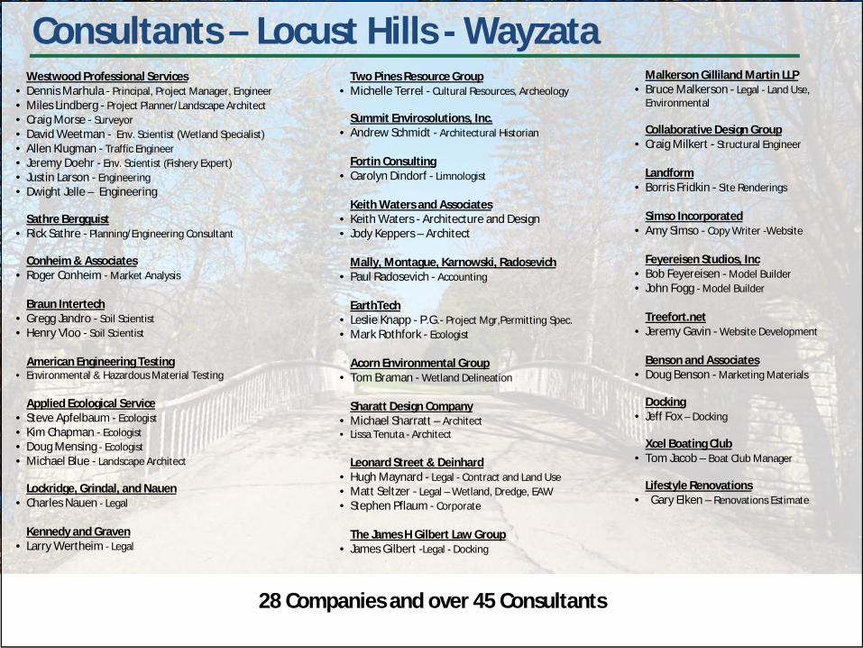
Consultants – Locust Hills - WayzataWestwood Professional Services
• Dennis Marhula - Principal, Project Manager, Engineer• Miles Lindberg - Project Planner/Landscape Architect• Craig Morse - Surveyor• David Weetman - Env. Scientist (Wetland Specialist)• Allen Klugman - Traffic Engineer• Jeremy Doehr - Env. Scientist (Fishery Expert)• Justin Larson - Engineering• Dwight Jelle – Engineering
Sathre Bergquist• Rick Sathre - Planning/Engineering Consultant
Conheim & Associates• Roger Conheim - Market Analysis
Braun Intertech• Gregg Jandro - Soil Scientist• Henry Vloo - Soil Scientist
American Engineering Testing • Environmental & Hazardous Material Testing
Applied Ecological Service• Steve Apfelbaum - Ecologist• Kim Chapman - Ecologist• Doug Mensing - Ecologist• Michael Blue - Landscape Architect
Lockridge, Grindal, and Nauen• Charles Nauen - Legal
Kennedy and Graven• Larry Wertheim - Legal
Two Pines Resource Group• Michelle Terrel - Cultural Resources, Archeology
Summit Envirosolutions, Inc. • Andrew Schmidt - Architectural Historian
Fortin Consulting • Carolyn Dindorf - Limnologist
Keith Waters and Associates• Keith Waters - Architecture and Design• Jody Keppers – Architect
Mally, Montague, Karnowski, Radosevich • Paul Radosevich - Accounting
EarthTech • Leslie Knapp - P.G.- Project Mgr,Permitting Spec.• Mark Rothfork - Ecologist
Acorn Environmental Group• Tom Braman - Wetland Delineation
Sharatt Design Company• Michael Sharratt – Architect• Lissa Tenuta - Architect
Leonard Street & Deinhard• Hugh Maynard - Legal - Contract and Land Use• Matt Seltzer - Legal – Wetland, Dredge, EAW• Stephen Pflaum - Corporate
The James H Gilbert Law Group• James Gilbert -Legal - Docking
Malkerson Gilliland Martin LLP• Bruce Malkerson - Legal - Land Use,
Environmental
Collaborative Design Group• Craig Milkert - Structural Engineer
Landform• Borris Fridkin - Site Renderings
Simso Incorporated• Amy Simso - Copy Writer -Website
Feyereisen Studios, Inc• Bob Feyereisen - Model Builder• John Fogg - Model Builder
Treefort.net• Jeremy Gavin - Website Development
Benson and Associates• Doug Benson - Marketing Materials
Docking• Jeff Fox – Docking
Xcel Boating Club• Tom Jacob – Boat Club Manager
Lifestyle Renovations• Gary Elken – Renovations Estimate
28 Companies and over 45 Consultants

City Permits/Approvals – Locust Hills - Wayzata
City of Wayzata• Planned Unit Development Zoning• Preliminary and Final Plats• Shoreland Conditional Use Permit • Wetland Conditional Use Permit• Grading Permit• Roadway Crossing Permit• Wetland (MCWD Rule D – Reviewed by City)• Stormwater Management for Land Development
Projects (MCWD Rule N – Reviewed by City)• Erosion Control Permit (MCWD Rule B Reviewed by
City)• Municipal Water and Sewer Connection Permit• Tree Removal Permit and Tree Preservation Plan• Wetland Conservation Act Approval (Wayzata LGU –
Reviewed by City of Minnetonka, MCWD, DNR and BWSR)
City of Minnetonka • Rezoning to Planned Unit Development• Master Development Plan• Conditional Use Permit for Impervious Trail in
Wetland Buffer• Approval of Wetland Replacement Plan• Right of Way Vacation Approval• Wetland Permit • Roadway Crossing Permit• Erosion Control Permit (MCWD Rule B – Reviewed by
City)• Stormwater Management for Land Development
Projects (MCWD Rule N – Reviewed by City)• Floodplain Alteration Approval (Rule C – Reviewed by
City)• Municipal Water and Sewer Connection Permit• Grading Permit• Bridge Permit• Right-of-Way Work Permit
29 Approvals and/or Permits between the two Cities

Other Permits/Approvals – Locust Hills - Wayzata
Minnesota Department of Health• Well Abandonment• Water Main Extension Approval• Water Appropriation Permit• Public Waters Work Permit• Variance for Treatment of Contaminated Groundwater
Hennepin County• Plat Review• Temporary and Permanent County Road Access Permits
(Minnetonka and Wayzata)• Permit for Utility Work in ROW
Minnesota Department of Natural Resources• Utility Crossing of Public Lands and Waters License• Aquatic Plant Management Control Permit (Not yet
Applied for)
Minnehaha Creek Watershed DistrictIn Minnetonka • Stream and Lake Crossing (Rule G)• Wetland Buffer (Rule )In Wayzata • Floodplain Permit (MCWD Rule C) • Stream and Lake Crossing (Rule G)
Minnesota Pollution Control Agency• 401 Water Quality Certification or Waiver• Sanitary Sewer Extension Approval• NPDES/ SDS General Permit• Development Response Action Plan Approval• Sanitary Sewer Connection Permit
U.S. Army Corps of Engineers with State Historic Preservation Office
• Corps of Engineers – 106 Historic Properties Mitigation –Memorandum of Agreement
U.S. Army Corps of Engineers• Corps of Engineers – 404 Wetland Permit • Corps of Engineers - 401 Water Quality Certification
Waive
Federal Emergency Management Agency• Letter of Floodplain Map Amendment (Not yet Received)
Lake Minnetonka Conservation District• Multiple Dock Design Approval and License
22 Additional Approvals and/or Permits (51 Total)

Land Development Process
Approval (Entitlement) Timeline
• While we used to plan on 4-6 months to get approvals we now need 1-2+ years. (PUD Examples)
• Locust Hills • 1 ¾ years from starting Sketch Plan to Final Plat Approval
• Woodland Cove • 2 ½ year process best case
• Our timelines have expanded and in turn increased costs and risks

Land Development Process
Developer thoughts about the process
• Each time you work on a development you add something to your list that you never heard of or encountered before. (new rules, new fees, new rule interpretations)
• The list never gets shorter.
• You can ask the same question multiple times and get different answers.
• You are always looking out for what will be the next Achilles heel. What did you miss.
• New rules are developed as a reaction to what we are proposing. This does not lead to open sharing of information/trust.
• Rules can change at any time, rarely repercussion to agencies, almost always repercussions to developers, usually adding more cost/burdens.

Land Development Process “What has been happening to land?”
Woodland Cove – Concept PlanAcres %
ROW - Public and Private 93 19%Open Space - Total 156 32%Commercial Areas 7 1%Residential Areas 234 48%
Total Acres 490 100%
Land Development Pie
48%Homes
19% ROW
32%OpenSpace

Land Development Process “What has been happening to land?”
Woodland Cove - Open Space Open Space Acres
% of Open Space
% of Development
General Open Space (Woods, Prairie)* 47 30% 10%Public and Private Parks* 36 23% 7.5%Storm Water 30 19% 6%Wetlands* 21 13% 4%Wetland Buffers* 22 14% 4.5%
Total Open Space 156 100% 32%* 45 wooded acres are included in these open space numbers
Wetlands 13% Woods &
Open Space30%
StormWater19%
Parks23%
Buffers14%

Parks – 36 Acres (7%)
12
Woodland CoveTotal Open Space:
Storm Water Treatment - 30 Acres (6%) (20% of Open Space)
Buffers - 22 Acres (4%)
Sedimentation basins, Infiltration and other low impact development techniques (LID) – 106 areas
Wetlands – 21 Acres (4%)
All Open Space – 156 Acres (32%)

Land Development Process “What has been happening to land?”
Woodland Cove
What is left to develop?• 234 acres out of 490 acres.
How many units are required?• Met Council/City Minimum Units 1,071 – Negotiated 2.2units/Acre – Less than current
requirement.
What does that mean?
• 234 acres/1071 units = 1/5 acre or 9,500 sq. ft. per lot• 1,071 lots 70’ x 135’ more of an urban standard, not typical for area 30 miles from
Minneapolis, 14 miles from 494.
• Not practical or possible to make all 9,500 sq. ft. SF lots• Would not meet the DNR shoreland standards 100’ width, 50% open space (23,000 sq.ft.
min lot size in overlay, 14,500 in R-1)
• Requires use of multi family housing options.

Product Category 3-8-10 Concept
Lakeshore Single Family 26
Lakefront Single Family 8
Custom Single Family 34
Large Lot Single Family: 140
Medium Lot Single Family: 174
Small Lot Single Family: 207
Single Family Totals: 589
Twin Homes: 54
Row Townhome: 207
Back to Back Townhome: 106
Multi-Story 115
Multi-Family Totals: 482
ALL UNITS TOTAL 1071
Woodland CoveConcept Data:
• 208 Lots - 1 – 1/2 acre
• 381 Lots – 1/4 acre - 12,000 to 1/5 acre 8,000 sq. ft.
• 484 Units – Multi-Family (Twin, TH, BB, Condo) – 45% of the total units

Land Development Process Storm Water Rules
What does our experience tell us about the evolution of storm water rules?
• Rules are getting more complicated
• Everyone is trying to catch up with an evolving field/body of knowledge and we are often caught in the middle.
• Many ways to review and analyze storm water. Often each organization, agency, uses different methods that may conflict with one another
• WinSLAMM, XP-SWMM, SWAT, RECARGA, P8, HydroCAD, etc. • Curve Numbers, etc. • To calibrate or not to calibrate, monitoring – throwing money
away?
• New rules tend to….. increase complexity, increase restrictions, increase uncertainty.
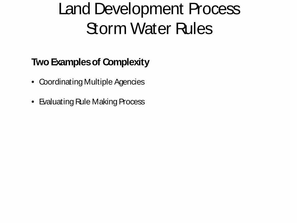
Land Development Process Storm Water Rules
Two Examples of Complexity
• Coordinating Multiple Agencies
• Evaluating Rule Making Process

Land Development Process Storm Water Rules – Example of Complexity
Woodland Cove
Background• Multi-Agencies• Agencies with formal and informal authority• Evolving storm water rules
• City (WSB) – Flocculation bias • Three Rivers Park District – Non-Degradation Interpretation bias• MCWD (Wenck)– More is better bias• Developer – Enough is enough bias(don’t take the bias comments to seriously)
Proactive Coordination • Decide to model a portion of the site to clarify rules, modeling,
assumptions , and interpretations. • All agencies participated voluntarily
NOTE: No time to explain why three agencies, multiple agencies not unusual.

Land Development Process Storm Water Rules – Example of Complexity
Broke the coordination process into stages 1. General Information
• Rules, how reviewed, their goals, etc.
2. What model(s) to use (Could spend 20 minutes on this)• P8 – pollutant and nutrient loading • HydroCAD for volume and rate
3. Assumptions for existing and proposed conditions.• Curve Numbers• Infiltration Rates
4. Modeled Existing Conditions
5. Modeled Proposed Conditions – Rubber hit the road
(process took 5+months May-Dec)

Land Development Process Storm Water Rules – Example of Complexity
Issues Raised/Resolved• Issue using P8 to model existing row crop. (understates the phosphorus
reductions)
• Verified culverts and field assumptions - Concrete vs. Corrugated
• Curve numbers (Soils Maps)
• # of other Technical questions…..(Time of concentration, downstream impacts, etc)• The right combination – sedimentation basins(used Min NURP) vs. infiltration
used 35% v. 65% mix
• Infiltration rates
NOTE: No time to talk about how the 885 page MN Storm Water Manual is fast becoming a hammer and/or an excuse for added regulation when convenient.
“The directive the Manual Sub-Committee received from the SSC was to produce a document that could be used as a single source to guide stormwater managers through the maze of Regulations”
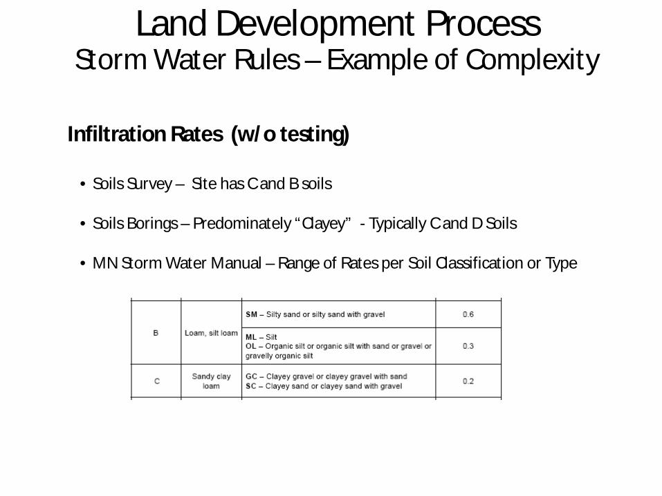
Land Development Process Storm Water Rules – Example of Complexity
Infiltration Rates (w/o testing)
• Soils Survey – Site has C and B soils
• Soils Borings – Predominately “Clayey” - Typically C and D Soils
• MN Storm Water Manual – Range of Rates per Soil Classification or Type

Land Development Process Storm Water Rules – Example of Complexity
Infiltration Rates (How implemented?)
Assume B soils – MN Storm Water Manual .3 -.6 inch/hour
• Regulator 1 – If no additional testing –take average of the MN Storm Water Manual .45.
• Regulator 2 – If no additional testing – use .3 plus safety factor
• Regulator 3 – Design it, build it and then we will test each infiltration area and see. Scary…..Did we do that with NURP ponds?

Land Development Process Storm Water Rules – Example of Complexity
Infiltration Rates (What we did)
• We wanted to get ahead of the curve. • Double Ring Tests - B soils .5 inch/hour – C soils .25 inch hour – (cost $350-
$500 each without any excavation) – Used .25 inch/hour for the model
• Realized this may not be enough, that .25 may be too conservative, we wanted to find out what we really had. (Thought more testing would add more certainty)
• Based on suggestion from Three Rivers we contacted John Gulliver U of M-They were willing to conduct test for us using the Modified Phillip Dunn method they developed.
• Asked the Agencies if they were o.k. with this. All Agreed.
• When we asked how and a where the test would be done. Wide range of opinion. (Explaining this alone could take 20 minutes)

Land Development Process Storm Water Rules – Example of Complexity
Infiltration Testing (Issues)
• Significant variability
• Testing open to wide interpretation
• While agencies say they would use actual tests over ranges in the MN Storm Water Manual we are concerned that this will depend on who you are working with and not the rule itself.

Land Development Process Storm Water Rules – Example of Complexity
.58 inches/hour
• Example of variability • A2 - Low - .001 cm/hour• B2 - High – 5.3 cm/hour
• Some rules call for 1 test per site. • Let’s hope it’s A2 and not B2• Some for 5 feet below practice, not
practical.• Testing each infiltration basin is also
not practical. • Commercially done each site could
cost $ 3,500.

Land Development Process Storm Water Rules – Example of Complexity
MCWD Proposed Rules• Generally we have worked well with MCWD.
• Have collaborated with them on several projects
• Current rules are going too far. New wetland buffer rule will added 50% more buffer area.
• Analyzed their rules
• Focus - abstraction credits for handling storage of 1” of rainfall over impervious surfaces.

Land Development Process Storm Water Rules – Example of Complexity
MCWD Proposed Credits
Assumptions • Abstraction credits in terms 1 ac. ft.• Costs above open space. Cost do not include typical seeding and preparation or
land cost.
Abstraction Credits (Ways to Meet Abstraction Requirement)
• Infiltration – Seems to be the standard and the most efficient if you have the space – Costs $ 25,000 -$100,000 per ac. ft. credit. (1 acre of land needed)
(Similar to the added costs for development for each acres of storm water treatment added)
• Infiltration Trench - $135,000 - $150,000 per ac. ft. credit (3/5 Acre of Land Needed) (100’ x 100’ x 4’)
Land Development Process Storm Water Rules – Example of Complexity
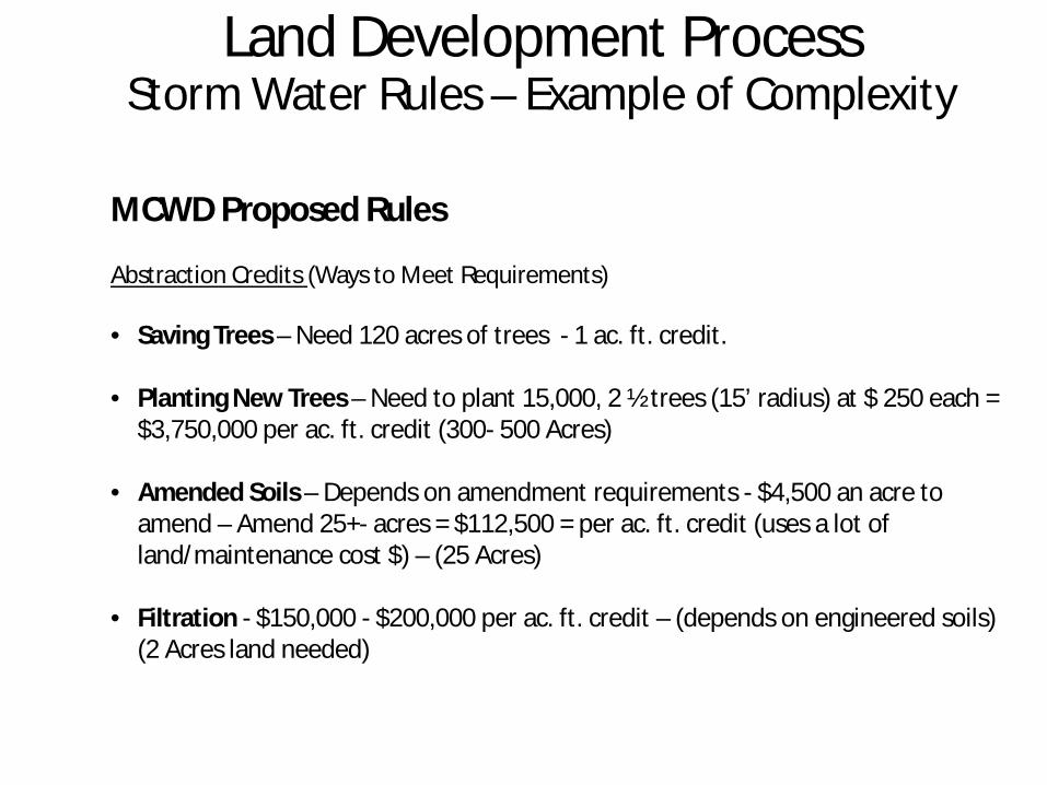
MCWD Proposed Rules
Abstraction Credits (Ways to Meet Requirements)
• Saving Trees – Need 120 acres of trees - 1 ac. ft. credit.
• Planting New Trees – Need to plant 15,000, 2 ½ trees (15’ radius) at $ 250 each = $3,750,000 per ac. ft. credit (300- 500 Acres)
• Amended Soils – Depends on amendment requirements - $4,500 an acre to amend – Amend 25+- acres = $112,500 = per ac. ft. credit (uses a lot of land/maintenance cost $) – (25 Acres)
• Filtration - $150,000 - $200,000 per ac. ft. credit – (depends on engineered soils) (2 Acres land needed)

Land Development Process Storm Water Rules – Example of Complexity
MCWD Proposed Rules (Other thoughts)
• To a developer when you talk about meeting storm water rules it gets confusing. What exactly are you trying to meet.
• Volume Control• Rate Control• Phosphorus Reduction• Pollutant ReductionTakes time to understand the interrelationships
• For Woodland Cove we planned for what we thought was worst case increased stormwater treatment areas from 3-4% to 6-8% of the site.
• Found that we barely meet the new rules on a site with over 30% open space.
• When you add doubling the areas for storm water with the 50% increase for wetland buffers, together almost 20 -30 acres of additional area was lost.

Land Development Process Storm Water Rules – Example of Complexity
How much protection do we need?
• Rules and agencies are always trying to protect the down side. Like using a safety fact or having to replace 2 times the wetland area impacted.
• Little focus on the up side. Such as the benefits from native vegetation getting established in infiltration areas, increasing infiltration rates over time.

Land Development Process Storm Water Rules – Example of Complexity
• Little focus on the up side. There is a common understanding that as native vegetation gets established infiltration rates go up!
AfterBefore

Land Development Process Summary
• We want to be good stewards.• Need rules that are clear.
• Consider setting a maximum land dedication, e.g. 5%?• We need to be able to understand and be able to plan a development prior to construction.
• Need rules that can be easily applied • Boards and Councils often do not understand the nuances of the technical regulation. • Staff members, while they may say they are implementing the boards policy, often have a
significant amount of discretion over exactly how the board implements a rule. (Non-Degradation – Oxymoron)
• Want rules that are fair, ones that don’t place an undue burden on a particular segment of the public.
• Pre-Settlement – means “essentially no change since before settlement”. If every agency set that as their benchmark we should all get out of our cars and start walking.
• Recognize that there are increasing demands on the costs to develop.
• Recognize that the land requirements for development have changed considerably over time.

End of Presentation
MPCA – MIDSDeveloper Perspective