archaeological evaluation and assessment of land at
TRANSCRIPT

Archaeological Evaluation andAssessment of land at Victoria House,
Military Road, Canterbury, KentMarch 2010
SWAT. ArchaeologySwale and Thames Archaeological Survey Company
School Farm Oast, Graveney RoadFaversham, Kent
ME13 8UPTel: 01795 532548 or 07885 700 112
www.swatarchaeology.com
Archaeological Evaluation and Assessment of Land at
Victoria House, Military Road, Canterbury
NGR: 615700 158400
Site Code: VHC-EV-10 (Planning Application CA/09/00085)
Report for
Jenner (Contractors) Ltd
SWAT. ARCHAEOLOGY
Swale and Thames Archaeological Survey Company
School Farm Oast, Graveney Road
Faversham, Kent
ME13 8UP
Tel; 01975 532548 or 07885 700 112
www.swatarchaeology.com

i
Contents
Figures……………………………………………………………………………. ii
Summary………………………………………………………………………… 1
Introduction…………………………………………………………………….. 1
Site Description and Topography………………………………………….. 1
Planning Background………………………………………………………….2
Archaeological Background…………………………………………………. 2
Aims and Objectives…………………………………………………………… 4
Methodology…………………………………………………………………….. 4
Monitoring……………………………………………………………………….. 5
Results…………………………………………………………………………….5
Finds……………………………………………………………………………… 6
Discussion………………………………………………………………………..6
Conclusion………………………………………………………………………. 6
Acknowledgements……………………………………………………………..7
References………………………………………………………………………..7
Appendix 1………………………………………………………………………. 8

ii
List of Figures
Figure 1. Location of Trenches
Figure 2. Location of Air Raid shelter
Figure 3. Trenches 1 & 2. Plan and sections
Figure 4. Trenches 3 &4. Plans and sections
Figure 5. Trenches 5 & 6. Plans and sections
Figure 6. Trench 7. Plans and sections
Figure 7. Plans and sections
Figure 8. Plans and sections.
Fig.1. T1. Facing North. Fig.2. T5. Air Raid shelter facing south-west.
Fig. 3. T7. Facing East. Fig. 4. T7. Facing East, additional work.

1
Archaeological Evaluation and Assessment of Land at Victoria House, Military Road, Canterbury
NGR: 615700 158400
Site Code: VHC-EV-10
SUMMARY
Swale & Thames Survey Company (SWAT) carried out an archaeological evaluation and
assessment of land on the site of the former late 19th c building Victoria House on Military
Road in Canterbury, Kent. A planning application (CA/09/00085) for the construction of
houses and flats with associated parking was submitted to Canterbury City Council (CCC)
whereby Canterbury City Council requested that an Archaeological Evaluation and
Assessment be undertaken in order to determine the possible impact of the development on
any archaeological remains. The work was carried out in accordance with the requirements
set out within an Archaeological Specification (CCC 2009) and in discussion with the
Archaeological Officer for Canterbury City Council.
The Archaeological Evaluation consisted of seven trenches which encountered no
archaeological features of any significant antiquity. The remains of a WWII air raid shelter
were exposed in trenches 5 and 6 at the southern end of the site.
The Archaeological Evaluation has therefore been successful in fulfilling the primary aims and
objectives of the Specification.
INTRODUCTION
Swale & Thames Survey Company (SWAT) was commissioned by Jenner (Construction) Ltd.
to carry out an archaeological evaluation and assessment at the above site. The work was
carried out in accordance with the requirements set out within an Archaeological Specification
(CCC 2009) and in discussion with the Archaeological Officer, Canterbury City Council. The
evaluation was carried out from the 15th-19th March 2010.
SITE DESCRIPTION AND TOPOGRAPHY
The development site located on the grounds of Victoria House, Military Road, Canterbury
(NGR 615700 158400) measures approximately 56m x 52m and lies c 20m OD on the
southern side of Military Road on relatively level ground situated on the south side of the
Stour Valley. The land slopes down to the Great Stour c 500m to the north, and to the south,
the ground rises on to the dip slope of the North Downs.
According the British Geological Survey (BGS), the underlying geology of the development
site is Pleistocene Head Brickearth. The soil overlaying the Brickearth is a fertile Calcareous
Brown Earth (CBE) which when well drained, as on this site, is considered good for

2
horticultural and arable use. This Brown Earth (CBE), (003), was encountered in Trenches 1,
2, 3, 4, 5, and 7. Only Trench 6, which was greatly disturbed, showed no evidence of this
context.
PLANNING BACKGROUND
A planning application (CA/09/00085) for the construction of houses and flats with associated
parking at the above site was submitted to Canterbury City Council (CCC) and subsequently
granted consent on 19th June 2009. Canterbury City Council requested that an Archaeological
Evaluation and Assessment be undertaken in order to determine the possible impact of the
development on any archaeological remains. The following condition was attached to the
planning consent:
“No development shall take place until the applicant, or their agents or
successors in title, has secured the implementation of a programme of
archaeological work in accordance with a written specification and timetable
which has been submitted to and approved by the Local Planning Authority”
Requirements for the archaeological evaluation comprised trial trenching targeting a
representative 4% sample of the impact area with trenches designed to establish whether
there were any archaeological deposits at the site that may be affected by the proposed
development. The results from this evaluation will be used to inform CCC of any further
archaeological mitigation measures that may be necessary in connection with the
development proposals.
ARCHAEOLOGICAL AND HISTORICAL BACKGROUND
Archaeological Background
Prehistoric
There are no finds or features of Palaeolithic or Mesolithic date recorded in the Canterbury
District Historic Environment Record (CDHER) within the 500m study area for Victoria House.
One polished stone axe head of Neolithic date was recovered from North Holmes Road. An
assemblage of prehistoric material recovered from an evaluation on Sturry Road may also be
of Neolithic date. Evidence of Bronze Age activity within the study area was centred around
Christ Church University during an evaluation and subsequent excavation where a number of
features were recorded (CAT 1996). No Iron Age features are listed in the CDHER for the
study area, but two findspots in the area contained Iron Age coins.
Roman
Investigations on and around the site of the Hospital of St John the Baptist on Northgate
3
recorded a series of metalled surfaces and flanking ditches associated with the Roman Road
to Reculver and evidence of a number of Late Roman buildings along a branching lane (CAT
1987). Later investigations at Northgate car park exposed the Roman road to Reculver (CAT
1996). Excavations at what is now Christchurch University revealed a substantial Roman
conduit that may have been part of the Roman town’s water system. A Roman cemetery
located off the Sturry Road was first identified during the 19th century when the area was
quarried for Brickearth on both sides of the road between the Artillery Barracks and Vauxhall
Pits (Victoria County History, Kent Vol.III, 1932). Much of the cemetery was lost through
quarrying and more recent investigations have not been able to ascertain its size and nature.
Early Medieval
The Early Medieval period saw noticeable growth within the study area. In 597AD the
Episcopal See was established at Canterbury which included St Augustine’s Abbey and
possibly an early foundation within the later precincts of St Gregory’s Priory. Excavations at
Christchurch University revealed probable 5th to 6th century occupation in the form of a
number of sunken floored buildings with associated features (CAT 1996).
Medieval
Growth within the study area continued well into the Medieval period with the establishment of
two ecclesiastical centres, St Gregory’s Priory, founded by Archbishop Lanfranc before 1086,
and the Hospital of St John the Baptist, founded on 1087. Archaeological excavations in the
late 1980s revealed much of the priory of St Gregory and cemeteries associated with the
Hospital (Tatton Brown 1989). The growth of these religious centres, including the Cathedral
and St Augustine’s, saw the construction of a number of water supplies within the study area.
They include two conduit houses centred within the high ground of what is now known as
King’s Park. One of these conduits, lying c 0.5km east of Victoria House, was fed by two large
ponds. The water was piped into a conduit towards the Cathedral and St Gregory’s Priory.
The course of the conduit is thought to run parallel with Military Road, and sections of it were
identified during evaluations in advance of construction of the Military Road/Sturry Road link
road. Early 19th century maps of Military Road and Barracks show two conduits, one following
the line of Military Road and the other diverting to the north and rejoining at the junction of
Military Road and Ruttington Lane. It is possible that these two conduits may in fact be 19th
century additions constructed during the development of the barracks, incorporating the
original Medieval system, as both of these conduits continue towards St Gregory’s and the
Cathedral. The second Conduit House lies c 0.5km south of Victoria House and fed water to
St Augustine’s Abbey. A Medieval map of the conduit and early post Medieval maps show
the site of Victoria House as undeveloped and agricultural with the possible existence of
vineyards in the surrounding area.

4
Post Medieval
A 1734 copy of a 1600 map of Canterbury included in Oxford Archaeology’s Desk-based
Assessment shows the site of Victoria House within the grounds of King’s Park. The land
remained relatively undeveloped until the late 18th century with the construction of Cavalry
Barracks within the grounds of King’s Park in 1795 and further infantry and artillery barracks
in the late 18th and early 19th century to stem the need for billeting of troops in Canterbury
during protracted wars including the Seven Years War, American War of Independence and
Napoleonic War. Most of the development of the barracks occurred north of Military Road,
with the site of Victoria House surviving as parkland and later a rifle range until the
construction Victoria House as stables in 1898. In addition to the stables there was a series of
ménages, riding school enclosures, between Victoria House and Ruttington Lane.
Contemporary with these developments was the construction of the Garrison Church of All
Saints east of Victoria House. The area south continued to be used as a drill ground and rifle
range as seen on the 3rd edition Ordnance Survey Map of 1907.
Historical Background
There are a number of historical sites within a 500m radius of the development area listed in
the Canterbury District Historic Environment Record including one World Heritage Site and
four Scheduled Ancient Monuments.
World Heritage Sites
Just within the southern periphery of the 500m study area lies St Augustine’s Abbey (OA 2), a
World Heritage Site and Scheduled Ancient Monument. The World Heritage Site of
Canterbury Cathedral and its precincts lie just outside the south west limit of the Study Area.
Scheduled Ancient Monuments
The four Scheduled Ancient Monuments with the Study Area are:
12th c Monastic Conduit House – Listed as KE 266 by English Heritage. This structure is
located in King’s Park and is associated with the water supply to St Augustine’s Abbey. It lies
c 450m to the south of the development area.
St Augustine’s Abbey and precincts - Listed as KE 49 by English Heritage. The Abbey and
precincts lie c 500m to the south west of the development area.
Conduit House and associated water works - Listed as KE 265 by English Heritage.
Located on Military Road and linked to the water supply to St Augustine’s Abbey, the Conduit
House lies c 400m east of the development area.
The Hospital of St John the Baptist - Listed as KE 382 by English Heritage. The Hospital
and associated buildings was founded in 1087 and lies c 500m northwest of the development
site in the Northgate area of Canterbury.
Listed Buildings

5
There are two Grade II* Listed Buildings within the 500m radius of the study area. Both are
within the Scheduled Area of the Hospital of St John the Baptist and comprise the Medieval
gatehouse fronting Northgate and the refectory.
There are eight Grade II Listed Buildings/Grade C Listed Churches within the study area.
They are:
Grade II Listed section of Medieval wall within the Scheduled Area of the Hospital of St John
the Baptist.
Grade C Listed mid 19th century Church of St Gregory
Grade II Listed 18th century house -114A Northgate.
Grade II Listed 16th century house – 113 and 114 Northgate.
Grade II listed 16th century house – 32 Northgate.
Grade II Listed house with part 15th century fabric – 30 Northgate.
Grade II listed Medieval house – 28 and 29 Northgate
Grade II Listed watermill with part Medieval fabric - Barton Mill on the Great Stour River. The
only extant Medieval watermill in Canterbury.
Victoria House
Victoria House was constructed in 1898 as stables with associated riding school ménages
near the Calvary Barracks north of Military Road. It became an Officers’ saddle and riding
club by 1935, and around that time a building was constructed on the eastern edge of the site.
The southern perimeter brick wall was also built to close off the miniature rifle range in the
centre of the site. A long northeast-southwest mound is seen on plans directly behind Victoria
House. It was during the evaluation that a reinforced concrete air raid shelter was exposed in
trenches 5 and 6. A Level 2 Photographic Survey was undertaken on the standing structure
before and during demolition. Sizes of the various elements of design can be calculated easily
from the standard size bricks used in its construction.
AIMS AND OBJECTIVES
The purpose of the evaluation, as set out within the Archaeological Specification (2009)
(Manual of Specifications, Part B) was to:
“a) ascertain the extent, depth below ground surface, depth of deposit, character, date,
significance and condition of any archaeological remains on site;
b) establish the extent to which previous development and/or other processes have
affected archaeological deposits at the site; and
c) establish the likely impact on archaeological deposits of the proposed development.”

6
Specific aims of the archaeological work were set out in the Archaeological Specification
(2009) (Manual of Specifications, Part A).
“The aim of this initial phase of evaluation work is to determine whether any significant
archaeological remains survive on site. Assessment of the results should provide
guidance on what mitigation measures would be appropriate. Such measures may
include further detailed archaeological excavation ahead of development; and/or an
archaeological watching brief during construction work. This specification sets out the
requirements for trial trenching on site. Further mitigation measures will be subject to
other documents or specifications which will need to be agreed with the Local
Planning Authority.”
METHODOLOGY
Trial trenching was carried out on 15TH March 2010, with the excavation of seven trenches
measuring 2m in width and approximately 15m in length (see below). Trench location was
agreed prior to the excavation between CCC and SWAT. The trenches were initially scanned
for surface finds prior to excavation. Excavation was carried out using a tracked 360º
mechanical excavator fitted with a toothless ditching bucket, removing the overburden to the
top of the first recognisable archaeological horizon, or natural, under the constant supervision
of an experienced archaeologist. Trenches were subsequently hand-cleaned to reveal
features in plan and carefully selected cross-sections through the features were excavated to
enable sufficient information about form, development date and stratigraphic relationships to
be recorded without prejudice to more extensive investigations, should these prove to be
necessary. All archaeological work was carried out in accordance with the specification.
A single context recording system was used to record the deposits, and context recording
numbers were assigned to all deposits for recording purposes; these are used in the report
and shown in bold.
After a site inspection by the CCC Heritage Officer on 16th March 2010, it was agreed that
three trenches (1, 5 and 7) should be partially remachined to test the depth of the Brown
Earth (003) which may have been masking archaeological features cutting the Head
Brickearth (004). This was undertaken on 19th March 2010 using a 1.5 tonne tracked machine
with toothless bucket.
MONITORING
Curatorial monitoring was carried out during the course of the evaluation.

7
RESULTS
All trenches were covered in various types of modern overburden with intact tarmac, and in
Trenches 4, 5 and 7, which lay to the south of the southern butt wall, turf and disturbed
garden soil.
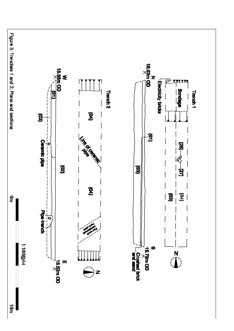
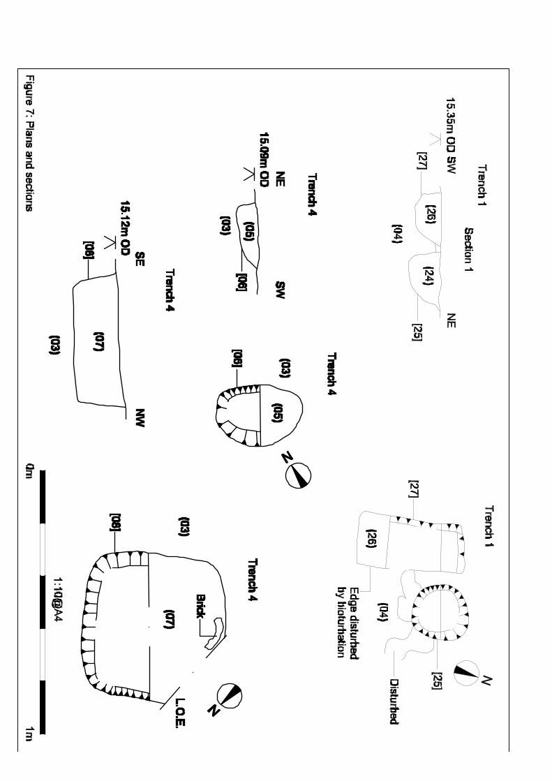
Trench 1
(15m x 2m x <1m)
Trench 1 was aligned north-south and located to the north of the site. It was the closest trench
to Military Road and the medieval conduit located parallel to the road. 0.25m of tarmac
overlay a bedding of crushed brick and sand. This bedding deposit sealed a thick (c 0.70m)
deposit of Calcareous Brown Earth (003). This geological deposit covered the natural Head
Brickearth (004). Due to the occurrence of (003), it was necessary to re-machine a 1m wide
trench along its length of trench 1 to expose the Head Brickearth (004) and get a
measurement of the depth of the Brown Earth (003). Two modern features cut these
geological layers. A round posthole [025] with a c 0.20m diameter contained post Medieval
brick fragments within its fill of redeposited Brown Earth (024). A small rectangular feature
[027] adjacent to [025] measured 0.40m x 0.20m. Its fill (026) contained one residual flint and
occasional flecks of ceramic building material (cbm) and clinker. The area around these two
features was disturbed by bioturbation, most likely animal burrowing, which disturbed the
eastern edge of [027]. No cultural material or archaeological features of great antiquity were
found, though one large flint with a worked face was retrieved from (003) during machining.
No evidence of the Medieval conduit system was encountered during the evaluation.
Trench 2
(15.25 x 2m x <1m)
This trench was aligned east–west at the north-eastern end of the site. The western third of
the trench had a concrete layer over a sand bedding up to 0.20m thick. East of this concrete
surface was a subsoil of equal depth consisting of redeposited Calcareous Brown Earth (002)
which was discoloured to a dark brown grey. These two layers covered CBE (003) which was
c 0.35m thick and sealed the Brickearth (004). No features besides two modern ceramic pipes
and their associated trenches were seen in this trench.
Trench 3
(14.75m x 2m x <0.90m)
This trench was aligned east-west and was located towards the eastern corner of site. The
western third of the trench had a tarmac surface over type 1 bedding (001) over subsoil (002).
These contexts overlay CBE (003) which measured c 0.60m thick and lay exposed at the
surface before the machining of the trench due to earlier demolition work. No features were

8
seen in this trench except for one toothed bucket cut created during the aforementioned
demolition work.
Trench 4 (15.35m x 2m x <0.80m)
This trench was aligned north-south and lay west of trench 3 near the centre of the site.
Running relatively east-west along the centre of this trench was a Victorian brick perimeter
wall, and the surface deposits reflect this. The northern half of the trench was covered in
disturbed tarmac over a type 1 bedding deposit (001), over subsoil (002) which was c 0.25m
thick. The southern half, which was outside the boundary wall and laid to grass, contained a
humic garden soil that was exposed when the turf was removed. This humic layer (023) was
up to 0.60m thick and was most likely an imported soil used to landscape the site during
construction of the council offices. Two features and one toothed machine cut were observed
cutting the CBE (003). One shallow posthole [006] measuring 0.32m x 0.23m x <0.08m was
filled with redeposited CBE (005) and contained no cultural material except for very small
flecks of cbm and coke. A sub-square feature [008] measured 0.55m x 0.55m x < 0.18m. Its
fill (007) was a mixture of redeposited CBE and Head Brickearth and contained large
fragments of brick (retained). The shape of this feature and its proximity to the toothed bucket
cut gives it the appearance of a JCB ‘foot’, which is plausible as the area was under
development during the construction of the council offices and these two features were sealed
by heavily disturbed humic soil (023) used to landscape the grassed area to the north of the
offices.
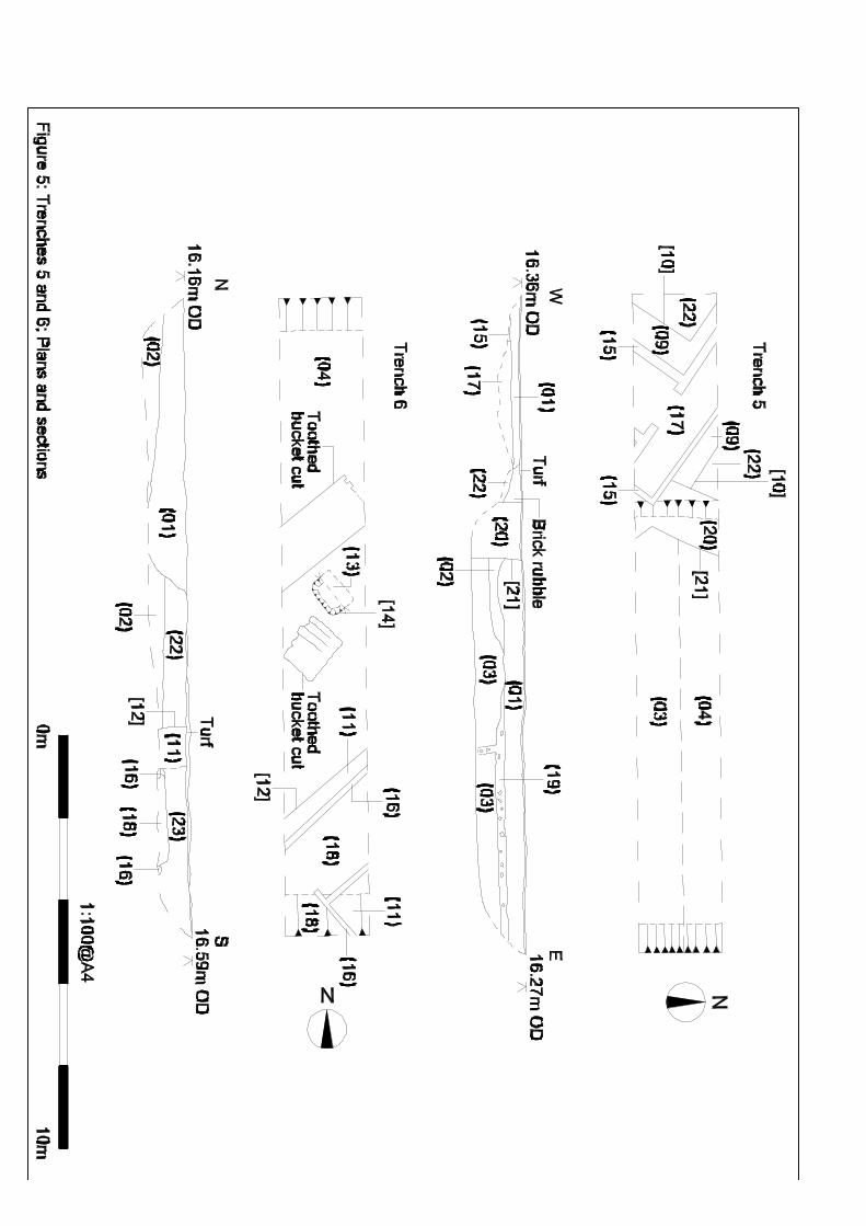
Trench 5
(16m x 2m x <1.20m)
Trenches 5 and 6 exposed a reinforced concrete air raid shelter (015) (016). Trench 5 was
covered in turf, and the western 5m contained the air raid shelter (015) which was covered by
modern overburden (001). A modern machine cut [021] cut the modern overburden (001) to
the east and the air raid shelter’s foundation cut and its fill [010](009) to the west. The
foundation cut [010] for the shelter cut a compacted gravel deposit (022) which was only
exposed up to a depth of 0.15m. This compacted deposit was also observed in trench 6. West
of the modern machine cut [021] was modern overburden (001) up to c 0.60m thick, and it
appears to have been used as a levelling deposit for the turf. Below this overburden was
subsoil (002) and a c 0.20m thick deposit of crushed brick and mortar (019) that lay on the
same horizon. The crushed brick and mortar deposit (019) was observed in both the north
and south-facing sections and may be contemporary with the landscaping of the area south of
the Victorian brick boundary wall. The air raid shelter walls (015) were comprised of concrete
reinforced with rebar and were up to 0.25m thick. A narrow 0.85m wide northwest-southeast
aligned corridor opened onto a doorway to a northeast-southwest aligned corridor measuring
c 1.50m wide. It was not possible to measure the surviving depth of the shelter due to the

9
amount of concrete rubble within the structure. Trench 5 was remachined on 19th March to
test the depth of the CBE (003). A 1m wide slot was cut along the length of the trench on its
north side to expose the Head Brickearth (004) and to expose any features that may have
been cutting it. The depth of the Calcareous Brown Earth {003) was up to c 0.70m thick, and
no features were seen cutting the Brickearth.
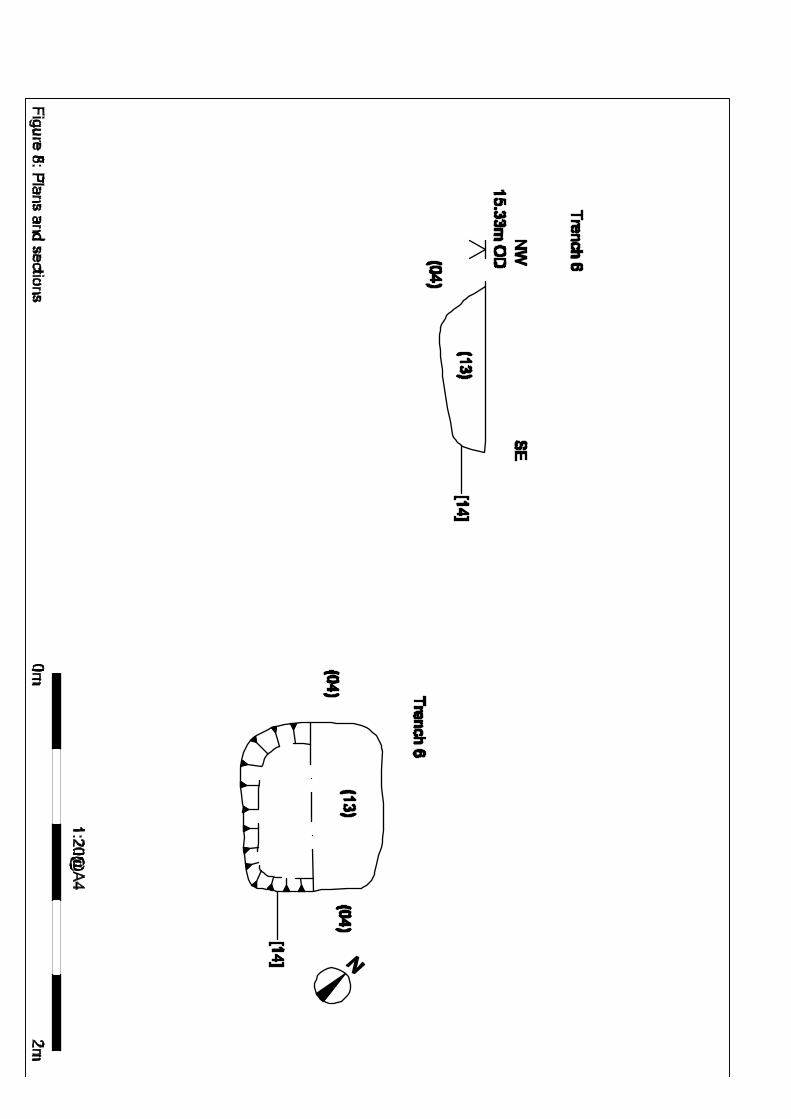
Trench 6
(15.50m x 2m x < 0.95m)
Trench 6 contained a northeast-southwest aligned 1.50m wide corridor of the air raid shelter
(016) and its return at the extreme southern end of the trench. When tied in with the exposed
walls in trench 5, the shelter consisted of the typical ‘H’ shape in plan common to many WWII
air raid shelters. A 1m thick deposit of modern overburden (001) covered subsoil (002) at the
northern end of trench 6 and cut a c 0.55m thick deposit of compacted gravel (022) which was
also cut by the foundation trench for the shelter [012]. This deposit (022) was also seen in
trench 5, but its date is uncertain as no cultural material was found. It has most likely been
greatly disturbed during the construction of the air raid shelter and more recently during
demolition work of Victoria House. The concrete walls of the shelter (016) were 0.15m-0.18m
thick but were badly damaged during demolition. The backfill (011) of the construction trench
[012] consisted of a mixed Brickearth and CBE matrix that was only visible in plan. The
shelter was covered by a humic deposit (023) up to 0.75m thick which is most likely the same
deposit seen in trench 4 which was used for landscaping during the construction of the
lawned area immediately in front of the council offices. One feature and two toothed bucket
machine marks were seen cutting the Head Brickearth (004). The sub-rectangular feature
[014] measured 0.90m x 0.74m x < 0.24m and was filled by (013) which consisted of
redeposited natural Brickearth containing two sherds of pottery, including one glazed post-
Medieval fragment.
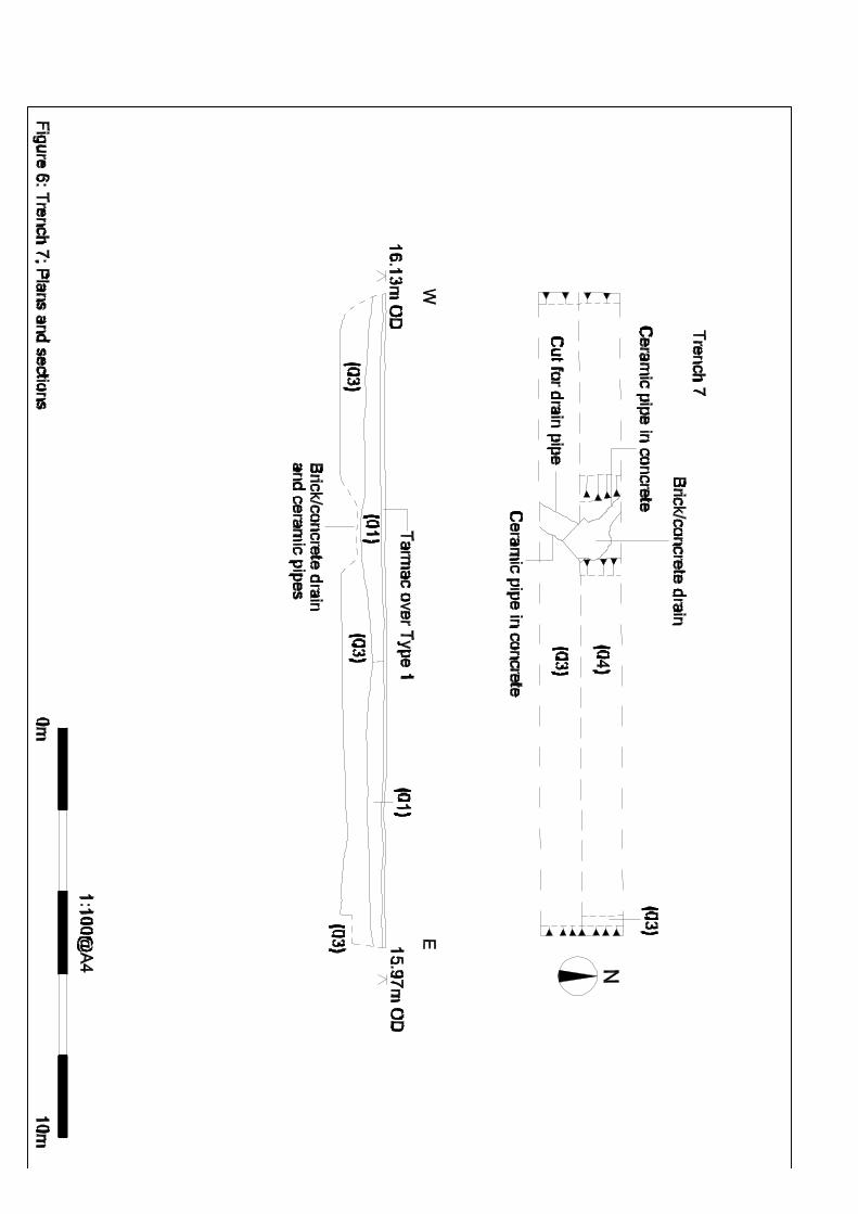
Trench 7
(15.75m x 2m x < 2.10m)
Trench 7 was completely sealed by undisturbed tarmac over a bedding layer of type 1
hardcore that covered a brick and mixed rubble deposit up to 0.50m thick. This rubble layer
covered CBE (003) up to 0.70m thick. No features were seen in trench 7 except for a brick
and concrete drain and two ceramic drain pipes set in concrete. This trench was remachined
on 19th March down to the Head Brickearth (004), and a number of struck flints were found in
the CBE (003) and retained.
FINDS
Few archaeological finds were recovered during the course of the evaluation, and all were
from the modern/post-medieval period except for flints found in the Calcareous Brown Earth
(003) in trenches 1 and 7.

10
DISCUSSION
The evaluation carried out at Victoria House, Military Road, Canterbury did encounter one
large feature, a WWII air raid shelter in trenches 5 and 6 and four small post-Medieval
postholes and pits. One of the pits context (013) produced two small fragments of glazed pot
dating from about 1625-1675 and 1650-1700/1725AD. One of the ‘pits’, in trench 4, is most
likely the depression from the foot of a JCB, as it was in close proximity of a toothed bucket
machine cut. There was no evidence of archaeological features before the post-medieval
period, and the only early artefacts discovered were Bronze Age struck flints found in the
natural deposit of Calcareous Brown Earth (003) in trenches 1 and 7. No evidence of the
Medieval conduit system was found in the trenches, nor was there any residual evidence
anywhere on the site. It can be assumed that the conduit lay north of the development area.
Historical maps of the northeast of Canterbury show this area relatively undisturbed until the
19th century when Military Road and vicinity was turned into barracks, firing ranges, drill
grounds and equestrian facilities.
CONCLUSION
The archaeological evaluation has been successful in fulfilling the primary aims and
objectives of the Specification. Despite the archaeological potential of the immediate
surrounding area the only archaeological features uncovered were probably from the post-
medieval period. The positioning of the seven trenches within the area at risk has ascertained
that the potential for encountering archaeology before the later post-medieval period is low.
This evaluation has therefore assessed the archaeological potential of land intended
for development. The results from this work will be used to aid and inform the
Archaeological Officer of Canterbury City Council any further archaeological
mitigations measures that may be necessary in connection with the development
proposals.
ACKNOWLEDGEMENTS
SWAT would like to thank Jenner (Contractors) Ltd for commissioning the project. Thanks are
also extended to Richard Cross (Canterbury City Council Archaeological Officer) for his
advice and assistance. Pottery dating by Nigel MacPherson-Grant. Julie Martin, James
Madden and Peter Cichy carried out the archaeological fieldwork; illustrations were produced
by Jonny Madden at Digitise This. The project was managed and the report collated by Dr.
Paul Wilkinson.
Julie Martin
21 March 2010

11
REFERENCES
SWAT Archaeology (2009) Specification for a Programme of Archaeological Evaluation and
Assessment of Land at Victoria House, Military Road, Canterbury, Kent. Swat Archaeology
(Swale and Thames Survey Company).
Institute for Archaeologists (IfA) Rev (2008) Standard and Guidance for archaeological field
evaluation.
Oxford Archaeology (2006) Victoria House, Military Road, Canterbury – Archaeological Desk-
based Assessment Oxford Archaeological Unit.
Website
www.soilsworldwide.net ‘Soil classification system of England and Wales’.

12
APPENDIX 1 – Kent County Council SMR Summary Form
Site Name: Victoria House, Military Road, Canterbury SWAT Site Code: VHC-EV-10 Site Address: Victoria House, Military Road, Canterbury, Kent Summary: Swale & Thames Survey Company (SWAT) carried out an archaeological evaluation at
Victoria House, Military Road, Canterbury in Kent. A planning application (CA/09/00085) for
the construction of houses and flats along with associated parking, was submitted to
Canterbury City Council (CCC) whereby Canterbury City Council Heritage and Conservation
(CCCHC) requested that an Archaeological Evaluation be undertaken in order to determine
the possible impact of the development on any archaeological remains. The work was carried
out in accordance with the requirements set out within an Archaeological Specification (CCC
2009) and in discussion with the Archaeological Officer, Canterbury City Council.
The Archaeological Evaluation consisted of seven trenches which encountered only one
significant archaeological feature which was of a modern date, and this was located in
Trenches 5 and 6. This feature was a WWII air raid shelter. Four small postholes and pits
contained mainly post Medieval artefacts. .
District/Unitary: Canterbury Parish: Northgate
Period(s): Tentative: Post Medieval/Modern NGR (centre of site : 8 figures): (NB if large or linear site give multiple NGRs): NGR 615700 158400 Type of archaeological work (delete) Evaluation Date of Recording: March 2010 Unit undertaking recording: Swale & Thames Survey Company (SWAT) Geology: Head Brickearth Title and author of accompanying report: Martin, J. (2010) Specification for a Programme of Archaeological Evaluation and
Assessment of Land at Victoria House, Military Road, Canterbury, Kent .
Summary of fieldwork results (begin with earliest period first, add NGRs where appropriate) As above (cont. on attached sheet) Location of archive/finds: SWAT Contact at Unit: Paul Wilkinson Date:23 March 2010

13