land at witherington farm downton...
TRANSCRIPT

Land at Witherington Farm Downton Wiltshire
Archaeological Evaluation
September 2014
for
Hive Energy Ltd
CA Project: 770098 CA Report: 14407

Land at Witherington Farm
Downton, Wiltshire
Archaeological Evaluation
CA Project: 770098 CA Report: 14407
prepared by Adam Howard, Archaeologist/Matt Nichol, Project Officer
date 15.09.14
checked by Richard Greatorex, Principle Fieldwork Manager
date 24.09.14
approved by Richard Greatorex, Principle Fieldwork Manager
signed
date 25.09.14
issue 01
This report is confidential to the client. Cotswold Archaeology accepts no responsibility or liability to any third party to whom this report, or any part of it, is made known. Any such party relies upon this report entirely
at their own risk. No part of this report may be reproduced by any means without permission.
© Cotswold Archaeology
Cirencester Milton Keynes Andover Building 11 Unit 4 Stanley House Kemble Enterprise Park Cromwell Business Centre Walworth Road Kemble, Cirencester Howard Way, Newport Pagnell Andover, Hampshire Gloucestershire, GL7 6BQ MK16 9QS SP10 5LH t. 01285 771022 t. 01908 218320 t. 01264 347630 f. 01285 771033

© Cotswold Archaeology
1
Land at Witherington Farm, Downton, Wiltshire: Archaeological Evaluation
CONTENTS
SUMMARY ..................................................................................................................... 3
1. INTRODUCTION ................................................................................................ 5
The site .............................................................................................................. 5
Archaeological background ................................................................................ 6
Archaeological objectives ................................................................................... 7
Methodology ....................................................................................................... 7
2. RESULTS (FIGURES 2-15) ............................................................................... 8
3. DISCUSSION ..................................................................................................... 19
5. CA PROJECT TEAM .......................................................................................... 21
6. REFERENCES ................................................................................................... 21
APPENDIX B: THE FINDS - TABLE 1: FINDS CONCORDANCE ................................. 34
APPENDIX C: THE PALAEOENVIRONMENTAL EVIDENCE ....................................... 35
APPENDIX D: OASIS REPORT FORM .......................................................................... 36
LIST OF ILLUSTRATIONS
Fig. 1 Site location plan (1:25,000).
Fig. 2 Trench location plan showing archaeological features, geophysical survey results
and services (1:2000).
Fig. 3 Trench location plan (NE corner of Site) showing archaeological features,
geophysical survey results and services (1:2000).
Fig. 4 Trench location plan (N central part of Site) showing archaeological features,
geophysical survey results and services (1:2000).
Fig. 5 Trench location plan (central part of Site) showing archaeological features,
geophysical survey results and services (1:2000).
Fig. 6 Trench location plan (SE part of Site) showing archaeological features, geophysical
survey results and services (1:2000).
Fig. 7 Trench 1: section and photographs
Fig. 8 Trench 4: section and photograph
Fig. 9 Trench 6: section and photograph
Fig. 10 Trench 9: section and photograph
Fig. 11 Trench 10: section and photograph

© Cotswold Archaeology
2
Land at Witherington Farm, Downton, Wiltshire: Archaeological Evaluation
Fig. 12 Trench 14: section and photograph
Fig. 13 Trench 17: section and photograph
Fig. 14 Trench 32: section and photograph
Fig. 15 Trench 36: section and photograph
Fig. 16 Trench 37: section and photograph
Fig. 17 Trench 38: section and photograph
Fig. 18 Trench 42: section and photograph
Fig. 19 Trench 50: section and photograph
© Cotswold Archaeology
3
Land at Witherington Farm, Downton, Wiltshire: Archaeological Evaluation
SUMMARY
Project Name: Land at Witherington Farm
Location: Downton, Wiltshire
NGR: 419775 124910
Type: Evaluation
Date: 11-22 August 2014
Planning Reference:
Location of Archive: Salisbury Museum Services
Accession Number: No receiving museum
Site Code: LWF14
An archaeological evaluation was undertaken by Cotswold Archaeology in August 2014 at
Land at Witherington Farm, Downton, Wiltshire. Fifty trenches were excavated.
Areas 3 and 5 contain the largest concentration of archaeological remains, forming a late
prehistoric agricultural landscape mostly consisting of a field lynchet system. Archaeological
potential diminishes to the south and west of these areas. Evaluation trenches 1 to 6, 8 to
10, 12 to 15, 17, 18, 22, 23, 25, 31 to 34, 36 to 38, 42, 43, 49 and 50 contained
archaeological features in the form of trackways, holloways, field boundaries, gullies, pits,
postholes and negative lynchets.
A large proportion of these features identified in the evaluation corresponded with those
revealed by the geophysical survey. Artefacts recovered during the evaluation, dated from
the Late Bronze Age to early Roman period, including pottery and burnt and worked flint.
The desk based assessment clearly established that the Site had been settled since at least
the Bronze Age, as evidenced by the excluded barrows (ring ditches) etc. The geophysical
survey established that there was evidence of agricultural manipulation of the landscape, in
the form of lynchets and boundary ditches, which clearly predated the current field patterns.
The evaluation has successfully confirmed the findings of both the earlier assessments,
identifying a predominantly agricultural landscape (as it is today), interspersed with the
occasional funerary monument introduced during the Bronze Age. It is assumed that some
of the agricultural manipulation of the landscape would have commenced in the Middle to

© Cotswold Archaeology
4
Land at Witherington Farm, Downton, Wiltshire: Archaeological Evaluation
Late Bronze Age and continued through the Iron Age and on into the Early Romano-British
period. It is noteworthy that the Romano-British finds are dated to the earlier part of the
occupation period only. The Site has been intensively ploughed through the ages and even
more so in recent times, so other evidence of discreet features (pits and post holes), such as
those identified in Trenches 17 and 32 may well have been lost.

© Cotswold Archaeology
5
Land at Witherington Farm, Downton, Wiltshire: Archaeological Evaluation
1. INTRODUCTION
1.1 In August 2014 Cotswold Archaeology (CA) carried out an archaeological evaluation
for Hive Energy Ltd at land at Witherington Farm, Wiltshire (centred on NGR:
419775 124910; Figure 1), hereafter referred to as the Site. The evaluation was
undertaken to support a planning application for a solar park on the Site.
1.2 The evaluation was carried out in accordance with a detailed Written Scheme of
Investigation (WSI) produced by CA (2014) and approved by Claire King, the
Assistant County Archaeologist for Wiltshire Council (WC). The fieldwork also
followed the Standard and Guidance for Archaeological Field Evaluation (IFA 2009),
the Management of Archaeological Projects (English Heritage 1991) and the
Management of Research Projects in the Historic Environment (MORPHE): Project
Manager’s Guide (English Heritage 2006). Fieldwork was monitored by Claire King,
including a site visit on 15/08/14.
The site
1.3 The Site is approximately 88ha in size and is located on the sloping sides of a dry
valley in a sparsely populated, rural area on a ridge of chalk hills at the northern
edge of the parish of Downton, Wiltshire (Figure 1). Approximately 1km to the west
is the broad valley bottom of the Wiltshire River Avon which flows from south to
north cutting the natural chalk. Three villages lie nearby; Downton, which lies
approximately 3km to the south-west and adjacent villages Alderbury and Whaddon
which lie approximately 1-2km north of the Site. Other settlement in the locality
comprises isolated farms and houses. Several large country estates lie within the
Avon valley. The nearest is Trafalgar House with the rear of the estate’s parkland
situated approximately 520m to the south-west of the Site. Local land use is
predominantly large arable fields with occasional areas of downland pasture on the
steeper slopes. To the south-east and to the north of the Site the geology changes
and the landscape becomes progressively dominated by woodland.
1.4 The northern boundary of the Site is also the parish boundary between Downton
parish and Alderbury parish. This boundary is marked predominantly by a lynchet
which may represent a ploughing headland. Below the lynchet is a dense hedgerow
which becomes increasingly wooded at the north-west end of the Site. The southern

© Cotswold Archaeology
6
Land at Witherington Farm, Downton, Wiltshire: Archaeological Evaluation
Site boundary was historically the boundary between Downton parish and
Standlynch parish and is marked by a low bank and a dense mature hedgerow. The
fields are largely featureless although a circular pond, likely to be a dewpond is
located within the north-easterly field. Separating investigation Areas 1 and 4 of the
Site (see Figure 2) from the remaining investigation areas on a north/south
alignment, is the footprint of the former (long since dismantled) railway line from
Salisbury to Poole. The original construction of the railway line (predominantly
wooded today), would have had a very negative impact on any archaeological
remains that may have existed within its footprint.
1.5 The dominant underlying bedrock geology of the Site is mapped as Newhaven
Chalk Formation - Chalk. Sedimentary Bedrock formed approximately 71 to 86
million years ago in the Cretaceous Period. Local environment previously dominated
by warm chalk seas. These rocks were formed in warm shallow 'Chalk' shelf seas
with little sediment input from land. They often consist of a calcareous ooze of the
microscopic remains of plankton (BGS Online).
1.6 Orientated east/west across the central lower level of Site near to the present Barn
location and to the south of the Site, two bands of superficial head deposits
consisting of clay, silt, sand and gravel are present. Superficial deposits formed up
to 3 million years ago in the Quaternary Period. Local environment previously
dominated by subaerial slopes. These rocks were formed from the material
accumulated by down slope movements including landslide, debris flow, solifluction,
soil creep and hill wash (BGS Online).
Archaeological background
1.7 There is evidence, derived principally from soil marks and cropmarks seen on aerial
photographs, for widespread buried archaeological remains. Such remains probably
include buried in-filled ditches from early Bronze Age ring ditches, different phases
of prehistoric field systems probably dating from the Bronze Age to the Roman
period and possibly some settlement remains. An oval enclosure may exist at the
site, which might represent an enclosed settlement site although the evidence for
this is limited to an indistinct crop mark.
© Cotswold Archaeology
7
Land at Witherington Farm, Downton, Wiltshire: Archaeological Evaluation
1.6 The geophysical survey undertaken earlier this year further defined much of the
cropmark evidence. A total of four ring ditches, numerous linear ditches and a
possible large enclosure were identified within the landscape (Stratascan 2014).
Most coincide with the existing aerial photographic evidence. However, the
background level of magnetic response was very low and as such some of the
anomalies associated with buried archaeology were relatively weak. Prior to
trenching commencing, it was considered probable that modern ploughing had
removed the near-surface magnetic component of many archaeological features.
1.7 A considerable quantity of later prehistoric and Roman period metalwork had also
been found at the Site via the Portable Antiquities Scheme, which added further
weight to the view that there was a strong likelihood for potentially important
archaeological remains to survive, (albeit probably truncated by ploughing).
Archaeological objectives
1.8 The objectives of the evaluation were to provide information about the
archaeological resource within the Site, including its presence/absence, character,
extent, date, integrity, state of preservation and quality. In accordance with the
Standard and Guidance for Archaeological Field Evaluation (IfA 2009), the
evaluation was designed to be minimally intrusive and minimally destructive to
archaeological remains. The information gathered will hopefully be sufficient to
enable the archaeological advisor to Wiltshire Council to identify and assess the
particular significance of any heritage assets recorded, consider the impact of the
proposed development upon them, and to avoid or minimise conflict between the
conservation of the heritage assets and any aspect of the development proposal, in
line with the National Planning Policy Framework (DCLG 2012).
Methodology
1.9 Fifty trenches were machine excavated and comprised 25no. x 30m x 2m trial
trenches and 25no. x 50m x 2m trial trenches (see Figure 2).
1.10 Trench 17 was extended several metres and measured up to approximately 32m x
1.8m north-west/south-east and up to 8.2m north-east/south-west in order to safely
excavate and fully investigate features found within each trench.

© Cotswold Archaeology
8
Land at Witherington Farm, Downton, Wiltshire: Archaeological Evaluation
1.11 All excavated trenches were set out on OS National Grid (NGR) co-ordinates using
Leica GPS. The final completed trench survey was recorded using Leica GP in
accordance with CA Technical Manual 4 Survey Manual (2012).
1.12 Due regard for known services was undertaken prior to, during excavation and upon
completion of the work at the Site. All work was undertaken in accordance with Safe
Systems of Work for – Avoiding Overhead Services & Underground Services. The
work was undertaken in line with a detailed Written Scheme of Investigation (WSI)
produced by CA (2014) and approved by WC.
1.13 All trenches were excavated by mechanical excavator equipped with a toothless
grading bucket. All machine excavation was undertaken under constant
archaeological supervision to the top of the first significant archaeological horizon or
the natural substrate, whichever was encountered first. Where archaeological
deposits were encountered they were excavated by hand in accordance with CA
Technical Manual 1: Fieldwork Recording Manual (2013).
1.14 Deposits/fills were assessed by Cotswold Archaeology for their palaeo-
environmental potential in accordance with CA Technical Manual 2: The Taking and
Processing of Environmental and Other Samples from Archaeological Sites (2003)
and were sampled and processed. All artefacts recovered during the evaluation
were processed in accordance with Technical Manual 3 Treatment of Finds
Immediately after Excavation (1995).
1.15 The archive and artefacts from the evaluation are currently held by CA at their
offices in Andover and Kemble respectively. Subject to the agreement of the legal
landowner all artefacts will be deposited with Salisbury Museum Services along with
the site archive. A summary of information from this project, set out within Appendix
D, will be entered onto the OASIS online database of archaeological projects in
Britain.
2. RESULTS (FIGURES 2-15)
2.1 50 trenches were excavated during the evaluation. Trenches 1, to 6, 8, to 10, 12 to 15, 17, 18, 22, 23, 25, 31 to 34, 36 to 38, 42, 43, 49 and 50 contained
archaeological features in the form of possible track ways, holloways, field
© Cotswold Archaeology
9
Land at Witherington Farm, Downton, Wiltshire: Archaeological Evaluation
boundaries, gullies, pits, postholes and negative lynchets. Trenches 7, 11, 16, 19, 20, 21, 24, 26 to 30, 35, 39, 40, 41, 44 to 48 had no features of archaeological
interest. The trenches consisted of topsoil (mid grey/brown, very friable silt/clay with
common sub-angular flint and moderate chalk inclusions) and chalk natural. Trench
11 had two layers of colluvium, and Trenches 3 and 28 contained subsoil. The
natural in Trench 21 comprised a clay matrix.
2.2 Artefact material was recovered from trenches 3, to 6, 8, 10 to 12, 14, 17 to 20, 22 to
34, 36, 38, and 42. This consisted of Late Prehistoric (Late Bronze Age to Iron Age)
and Roman pottery, 3.048kg of burnt unworked flint, and 55 pieces of worked flint
(two of which were also burnt). Two fragments from an iron rod of modern date were
also recovered from the topsoil of Trench 11.
2.3 Trench 1 (Figures 2 & 3) Trench 1 contained several ditches 102, 104, 106, 108, 110, 112 all of which were
linear in plan and on an east-west alignment, all were cut into the natural, 101, and
sealed by the topsoil, 100. Three of these ditches may relate to features identified by
the geophysical survey which are on the same alignment. Ditch 102 had shallow
concave sides and a concave base this was interpreted as a plough furrow, and was
filled by 103. Ditch 104, had rounded corners, moderate concave sides, and a
concave base, this was interpreted as a field boundary, and was filled by 105. Ditch
106 had rounded corners, moderate concave sides and a v-shaped base, this was
interpreted as a plough furrow, and was filled by 107. Ditch 108 had rounded
corners, shallow, concave sides and a flat base; this was interpreted as a possible
boundary ditch and was filled by 109. Ditch 110 had rounded corners, shallow
concave sides, and a flat to concave base; this was interpreted as a field boundary
and was filled by 111. Ditch 112 had rounded corners, shallow concave sides, and a
v shaped base this was interpreted as a plough scar and filled by 113.
2.4 Trench 2 (Figures 2 & 3)
Trench 2 contained a negative lynchet, 202 and a ditch 203 both were NE/SW
aligned and linear in plan. Lynchet 202 had rounded corners, moderate concave
sides, and a flat base and was filled by 205. It cut ditch 203, which had rounded
corners, moderate concave sides, and a flat base. This ditch relates to a feature
identified by the geophysical survey. Ditch 203, was filled by 204.

© Cotswold Archaeology
10
Land at Witherington Farm, Downton, Wiltshire: Archaeological Evaluation
2.5 Trench 3 (Figures 2 & 3)
Trench 3 contained topsoil, 300, subsoil, 301 and natural 302, and a single negative
Lynchet 303. 300 contained an assemblage of worked and burnt flint one of which
was a core with two platforms. Lynchet 303, was linear in plan, and had moderate
straight sides, and an irregular base. This was filled by 304. Lynchets 303, 402 and
507 (see Trenches 4 and 5 below) relate to features identified by the geophysical
survey.
2.6 Trench 4 (Figures 2, 3 & 8)
Trench 4 contained a negative Lynchet 402, a furrow 404 and a possible holloway
408. Lynchet 402 was linear in plan on a NE/SW alignment, had imperceptible brake
of slope from the surroundings and had straight sides and a flat base, this was filled
by 403. Furrow 404, was not excavated and was filled by 405. Holloway 408, was
linear in plan with a shallow concave base and filled by 406. Topsoil 400 contained a
worked flint flake. Lynchets 402, 303 and 507 appear to form part of the same
geophysical anomaly.
2.7 Trench 5 (Figure 2 & 3)
Trench 5 contained a trackway 502, pits 503 and 505 and a negative lynchet 507.
Trackway 502 was linear in plan, with moderate straight irregular sides, with an
undulating base and a N/S alignment. It was filled by 501. Pit 503, was sub-circular
in plan, rounded but irregular corners, very steep near vertical sides, and an
irregular base and filled by 504. Pit 505 was sub-circular in plan, with rounded
irregular sides, very steep near vertical sides, and an irregular concave base. It was
filled with 506 which contained burnt flint. A sample was taken from 506, but due to
the poor quality of the sampled material, no interpretation was possible. Lynchet 507
was linear in plan, with a slightly rounded break of slope, very gentle sides, flat base,
with a N/S alignment and filled by 508 and 510. Lynchets 507, 402 and 303 relate to
different sections of same archaeological anomaly identified by the geophysical
survey.

© Cotswold Archaeology
11
Land at Witherington Farm, Downton, Wiltshire: Archaeological Evaluation
2.8 Trench 6 (Figures 2, 3 & 9) Trench 6 contained ditch 602. The ditch was linear in plan, with straight corners, NE
side straight, SW side straight to slightly curved, and a flat base, on an E/W
alignment. It was filled by 601. It is on the same alignment curve as 1002, and may
form part of a holloway or trackway boundary and both relate to anomalies identified
by the geophysical survey.
2.8 Trench 8 (Figures 2 & 3) Trench 8 contained a layer of Colluvium 801, and a negative lynchet 803. Lynchet
803 was linear in plan, with straight moderate sides, concave to flat base, E/W
alignment, and filled by 804. 803 relates to a feature identified by the geophysical
survey. Topsoil 800 contained burnt flint.
2.9 Trench 9 (Figures 2, 3 & 10)
Trench 9 contained ditch 902. Ditch 902 was linear in plan, had rounded corners,
moderate sides, and a concave base with a NE/SW alignment. It was filled by 903.
The ditch is on the same alignment as a geophysical feature which is located further
to the southeast.
2.10 Trench 10 (Figures 2, 3 & 11)
Trench 10 contained holloway 1002. Holloway 1002 was linear in plan, with gradual
irregular sides, and an undulating base. It was filled by 1003 which contained a
worked flint chip. Topsoil 1000 contained a flint flake. It is on the same alignment
curve as 602, and may form part of a holloway or trackway boundary which relates
to a feature/features identified by the geophysical survey.
2.11 Trench 12 (Figure 2)
Trench 12 was targeted on a geophysical anomaly and contained a negative lynchet
1203. Lynchet 1203 was linear in plan, with strait sides, a flat base, and was aligned
NNE/SSW. The lynchet relates to a feature identified by the geophysical survey. It
was filled by 1201, which contained pottery with unfeatured bodysherds in a flint-
and-quartz tempered fabric of Late Bronze Age to Iron Age date and pottery in a

© Cotswold Archaeology
12
Land at Witherington Farm, Downton, Wiltshire: Archaeological Evaluation
sand-tempered fabric dating to the Middle to Late Iron Age. Topsoil 1200 also
produced pottery of the Late Bronze Age to Iron Age date.
2.12 Trench 13 (Figure 2)
Trench 13 contained a negative lynchet 1302. Lynchet 1302 was linear in plan, with
rounded corners, with shallow concave sides, and a flat base. The lynchet relates to
a feature identified by the geophysical survey. It was a filled with 1303 and 1304.
2.13 Trench 14 (Figures 2, 4 & 12)
Trench 14 contained a negative lynchet 1402. Lynchet 1402 was linear in plan, with
gradual concave sides, a flat base with a shallow brake of slope. It was filled with
1403 which produced several unfeatured bodysherds of 1st century Roman date
and three flint flakes, a blade, a notched flake and burnt flint.
2.14 Trench 15 (Figure 2 & 4)
Trench 15 contained ditch 1502. Ditch 1502 was linear in plan, had rounded corners,
shallow concave sides, and a flat base. The ditch relates to a feature identified by
the geophysical survey. It was filled by 1503.
2.15 Trench 17 (Figures 2, 4 & 13)
Trench 17 contained lynchets 1703 and 1705 and postholes 1707 and 1709.
Lynchet 1703 and lynchet 1705, were both irregular in plan, and had rounded
corners, concave gradual sides, and a gentle sloping flat base. They were filled by
1704 and 1706 respectively. Posthole 1707 was circular in plan, straight/slightly
irregular asymmetrical sides, and a v shaped base it was filled by 1708. Posthole
1709 was circular in plan, with straight near vertical sides, and a flat rounded base
and filled by 1710. The two lynchets relate to features identified by the geophysical
survey, which converge on one another; one an approximate N/S alignment and the
other on an approximate E/W alignment. Both were relatively shallow and had
clearly been heavily truncated by ploughing, Topsoil 1700 produced a flint flake and
burnt flint.

© Cotswold Archaeology
13
Land at Witherington Farm, Downton, Wiltshire: Archaeological Evaluation
2.16 Trench 18 (Figure 2)
Trench 18 contained lynchet 1803. The lynchet was linear in plan with gentle
concave sides and a flat base and relates to a feature identified by the geophysical
survey. It was filled by 1801, which contained worked flint.
2.17 Trench 22 (Figure 2)
Trench 22 contained a feature which could either be a holloway or negative lynchet
2202 and ditch 2204. Feature 2202 was linear in plan with rounded to strait gentle
sides and a flat gradually sloping base with a SW/NE alignment. This may relate to a
feature identified by the geophysical survey. It was filled by 2203. Ditch 2204 was
linear in plan, the NW side is strait the SE side is gradual concave and a flat base,
with a SW/NE alignment. The ditch was filled by 2205. Topsoil 2200 contained burnt
flint.
2.18 Trench 23 (Figure 2)
Trench 23 contained lynchet 2303. The lynchet was linear in plan, with shallow
concave sides, a flat base, and an E/W alignment. The lynchet relates to a feature
identified by the geophysical survey. Lynchet 2303 was filled by 2301. Topsoil 2300 produced one flint end scraper, worked flint flakes and burnt flint.
2.19 Trench 25 (Figure 2)
Trench 25 contained ditch 2503. The ditch was linear in plan, with moderately
sloping sides, and an asymmetrical v shaped irregular base, and was aligned N/S.
Ditch 2503 relates to a feature identified by the geophysical survey. It was filled by
2504, 2505 and 2506. Fill 2505 produced three moderately corticated flint flakes, all
of which were in a fresh condition with no edge damage. They were undiagnostic
waste flakes but may indicate a broad prehistoric date for this fill. Fill 2505; also
produced a small amount of degraded animal bone which was so poorly preserved
that species identification was not possible.

© Cotswold Archaeology
14
Land at Witherington Farm, Downton, Wiltshire: Archaeological Evaluation
2.20 Trench 31 (Figure 2)
Trench 31 contained ditch 3102. The ditch was not excavated and was on the same
alignment as 3303. This may relate to a feature identified by the geophysical survey
in the southern part of the trench, a possible ploughed out furrow was identified on
the same alignment as a feature in the northern part of the trench. Ditch 3102 was
filled by 3103. Topsoil 3100 produced worked and burnt flint.
2.21 Trench 32 (Fig 2, 5 & 14)
Trench 32 contained pits 3202, 3205, 3209, 3212, 3215, and posthole 3218. Pit
3202 was sub oval in plan, had rounded corners, with very steep almost vertical
sides, and a concave base. It was filled by 3203 and 3204. Pit 3205 was sub oval in
plan, with rounded corners, steep almost vertical sides, and a concave base. It was
filled by 3206. Pit 3209 was sub oval in plan, with rounded corners, moderate to
vertical sides, and a concave undulating base. It was filled by 3211 and 3210. Pit
3212 was sub oval in plan, with rounded corners, moderate to vertical sides, and a
flat base. It was filled by 3213 and 3214. Pit 3215 was sub-oval in plan, with rounded
corners, irregular moderately sloping sides, and a concave base. It was filled with
3216 and 3217. These pits were identified as a single geophysical feature. Posthole
3218 was circular in plan, with rounded corners, steep almost vertical sides, and a
gradual concave base. It was filled by 3208 and 3207. Posthole 3218 cut pit 3205.
Topsoil 3200 produced worked and burnt flint.
2.22 Trench 33 (Figure 2 & 5)
Trench 33 contained a single gully 3303. The gully was linear in plan, with moderate
concave sides, and a shallow concave to flat base, with an E/W alignment. The gully
relates to a feature identified by the geophysical survey. It was filled by 3304.
Topsoil 3300 produced burnt flint.
2.23 Trench 34 (Figure 2)
Trench 34 contained pits 3402, 3404 and posthole 3406. Pit 3402 was circular in
plan, with smooth rounded corners, moderately sloping sides, and an undulating/flat
base. It was filled with 3403 which contained burnt flint. Pit 3404 was circular in plan,

© Cotswold Archaeology
15
Land at Witherington Farm, Downton, Wiltshire: Archaeological Evaluation
with smooth rounded corners, steep concave sides, and an undulating/flat base. It
was filled by 3405. Posthole 3406 was circular in plan, with smooth rounded corners,
moderate concave sides, and a flat base. It was filled by 3407. Topsoil 3400
contained worked flint and burnt flint.
2.24 Trench 36 (Figures 2, 5 & 15)
Trench 36 contained a single ditch 3602. The ditch was linear in plan, with gradual
strait sides, flat base, and a N/S alignment and appears to be associated with a field
system on a N/S and E/W alignment. The ditch relates to a feature identified by the
geophysical survey. It was filled by 3603 which contained worked and burnt flint.
2.25 Trench 37 (Figures 2, 5 & 16)
Trench 37 contained ditch 3703 and 3705. Ditch 3703 was linear in plan, with
gradual strait sides, an irregular base, and a NNW/SSE alignment. It was filled by
3704, which produced poorly preserved animal bone. Ditch 3705 was linear in plan,
gradual strait sides, with shallow concave base (the sides and base are irregular due
to natural chalk), and was aligned N/S. It was filled with 3706. Both features were
identified by the geophysical survey.
2.26 Trench 38 (Figures 2, 5 & 17)
Trench 38 was originally targeted on two geophysical anomalies, which were
interpreted as two converging ditches, but once the overburden was stripped, only
pit 3804 was revealed. Pit 3804 was sub-oval in plan, with irregular/rounded corners,
and gradual concave sides with a concave irregular base. It was filled by 3805 and
3806. Secondary fill 3806 contained Late Bronze Age to Iron Age pottery and burnt
and worked flint.
2.27 Trench 42 (Figures 2, 6 & 18)
Trench 42 contained a ditch 4204 and tree throw 4202. Ditch 4204 was linear in
plan, with steeply sloping v shaped sides, a concave rounded base, and aligned
N/S. The ditch was identified on the geophysical survey. It was filled by 4205 (which
contained worked flint) and 4206. Ditch 4204, forms part of the same enclosure as
4303, (see below).

© Cotswold Archaeology
16
Land at Witherington Farm, Downton, Wiltshire: Archaeological Evaluation
2.28 Trench 43 (Figure 2)
Trench 43 contained ditch 4302. Ditch 4304 was linear in plan, with steeply sloping v
shaped sides, and a concave rounded base. The ditch was identified on the
geophysical survey. It was filled with 4303. It is clearly part of the same
ditch/enclosure system as 4204 above.
2.29 Trench 49 (Figures 2 & 6)
Trench 49 contained lynchet 4902. Lynchet 4902 was linear in plan, with moderate
concave sides and an irregular base, with a N/S alignment. The lynchet was
identified by the geophysical survey. It was filled by 4903.
2.30 Trench 50 (Figures 2, 6 & 19)
Trench 50 contained negative lynchet 5003. Lynchet 5003 was linear in plan,
shallow concave sides, flat base, NE/SW alignment. This lynchet relates to a feature
identified by the geophysical survey. It was filled by 5002.
The finds evidence
2.31 The finds assemblage consisted of worked and burnt flint and Late Bronze Age to
Roman pottery. Modern metal work was also recovered.
Pottery: Late Prehistoric
2.32 Pottery which is dateable to the Late Prehistoric period (spanning the Late Bronze
Age and Iron Age) on the basis of fabric and firing characteristics comprises a total
of six unfeatured bodysherds in a flint-and-quartz tempered fabric recorded in topsoil
1200 (Trench 12) and pit fill 3806 (Trench 38).
2.33 A total of 10 sherds of pottery in a sand-tempered fabric were recovered from
colluvium 1102 (Trench 11) and ditch fill 1201 (Trench 12). Included amongst the
sherds from colluvium 1102 (Trench 11) was a rim sherd from a globular jar with a
short, everted rim, which is a form commonly dating to the Middle to Late Iron Age.

© Cotswold Archaeology
17
Land at Witherington Farm, Downton, Wiltshire: Archaeological Evaluation
Pottery: Roman
2.34 Negative lynchet 1403 (Tr. 14) produced seven unfeatured bodysherds, comprising:
one in a wheelthrown, fine grog-tempered fabric, which probably dates to the 1st
century; three sherds of greyware and three sherds in a black-firing, sand-tempered
fabric. The latter two types of pottery are only broadly dateable to the Romano-
British period.
Metal objects
2.35 Two fragments from an iron rod of modern date were recovered from topsoil 1100
(Tr 11).
Worked flint 2.36 A total of 55 worked flint items was recorded, in addition to 115 pieces of burnt,
unworked flint weighing a total of 3.048kg. Two pieces of worked flint had also been
subjected to burning. The majority of struck flint (67%) was recovered from topsoil or
as unstratified finds.
2.37 The lithics comprised: 46 flakes; two blades; one chip; two cores; one retouched
flake; two end scrapers; and one notch. The waste flakes were only broadly
dateable to the prehistoric period. The core from topsoil 300 (Tr. 3) had two
platforms, with only two flakes removed; that from topsoil 2800 (Tr. 28) was also
used to produce flakes and was a scruffy, multi-platform type. Both are suggestive of
Late Neolithic/Bronze Age flint working.
2.38 One end scraper, from topsoil 2300 (Tr. 23), was made on a thick flake with semi-
abrupt, irregular but fairly neat retouch on the distal dorsal edge. The other, from
topsoil 2800 (Tr. 28), was made using steep, irregular retouch, also on the distal
dorsal edge. Neither scraper was a diagnostic type. The bulk of the flint (89%) was
heavily corticated white and most was in a rolled and edge-damaged condition,
which would be in keeping with redeposition.
2.39 Three flakes were recovered associated with pottery of Late Bronze Age to Iron Age
date in pit fill 3806 (Tr. 38). Two of the flakes were fully corticated white and in fresh
(unrolled), undamaged condition. The third was moderately corticated and displayed
a moderate degree of edge damage, so this deposit may have been subject to some
disturbance.

© Cotswold Archaeology
18
Land at Witherington Farm, Downton, Wiltshire: Archaeological Evaluation
2.40 Ditch fill 2505 (Tr. 25) produced three moderately corticated flint flakes, all of which
were in a fresh condition with no edge damage. They were undiagnostic waste
flakes but may indicate a broad prehistoric date for this deposit.
2.41 Three flakes, a blade and a notched flake recovered from negative lynchet 1403 (Tr.
14) were all heavily corticated but had sustained a degree of rolling and edge
damage, suggesting that this deposit had been disturbed: Roman pottery was also
recovered from this deposit. The notched flake was well made with a notch formed
from fine, regular, semi-abrupt retouch in the centre of the right ventral edge.
2.42 Much of the burnt flint is fully calcined, resulting in a pale grey coloration and heavy
crazing. This type of material is often encountered on Middle/Late Bronze Age sites,
where it may have been used for cooking/water heating or, when crushed, for
inclusion within pottery and other ceramics.
Faunal Remains
2.43 Three fragments (12g) of animal bone were recovered from two deposits. The bone
had suffered a high level of surface erosion and was so poorly preserved that
species identification was not possible. As such no useful interpretative data could
be obtained.
Palaeo-environmental Evidence
2.44 One environmental sample (20 litres of soil) was retrieved from a single deposit with
the intention of recovering evidence of industrial or domestic activity and material for
radiocarbon dating. The sample was processed by standard flotation procedures
(CA Technical Manual No. 2).
Undated 2.45 Sample 1 was recovered from fill 506 within pit 505 (Tr. 5). The samples contained a
small number of modern roots and a single carbonised cleavers (Galium aparine)
seed. A small amount of poorly preserved, highly fragmented charcoal was present.
Identification of the charcoal was not possible due to its crumbly and fragmented
nature. The paucity of the ecofactual evidence means no further interpretative
information is possible. There is no material available for radiocarbon dating.
© Cotswold Archaeology
19
Land at Witherington Farm, Downton, Wiltshire: Archaeological Evaluation
3. DISCUSSION
3.1 Areas 3 and 5 contain the largest concentration of archaeology forming a Late
Prehistoric agricultural landscape consisting largely of lynchet land management.
Archaeological potential diminishes to the south and west of these areas. Evaluation
trenches 1 to 6, 8 to 10, 12 to 15, 17, 18, 22, 23, 25, 31 to 34, 36 to 38, 42, 43, 49
and 50 contained archaeological features in the form of track ways, holloways, field
boundaries, gullies, pits, postholes and negative lynchets. A large proportion of
these features were identified by the geophysical survey. Artefacts recovered date
from the Late Bronze Age through to the Roman period including pottery, burnt and
worked flint.
Area 1
3.2 Trenches 24 and 26 contained no archaeology. Topsoil 2400 produced burnt flint.
Trench 25 contained a single ditch 2503 which produced worked flint of prehistoric
date and some animal bone.
Area 2
3.3 Trenches 19, 20, and 21 contained no archaeology. Trench 17 contained two
negative lynchets, 1703 and 1705 that may have once formed the corner of a field
system which was also marked by postholes 1707 and 1709. Trenches 18, 22 and 23 also contained negative lynchets. All of these features were identified by the
geophysical survey. Lynchet 1803 and topsoils 1700, 2200, and 2300 produced
worked and burnt flint.
3.4 Area 3
Trenches 7, 11 and 16 contained no archaeology; however colluvial deposit 1102
produced Middle to Late Iron Age pottery. Trench 1 contained five ditches and a
plough scar which were on the same alignment as geophysical results. Features
were excavated in Trenches 3, 4 and 5 and may form a single negative lynchet (303,
402 and 507). A single sample from pit 505 was taken (Trench 5) which produced
poorly preserved, highly fragmented charcoal which was not identifiable and not
suitable material for radiocarbon dating. Ditch 602, from Trench 6, and holloway
1002 from Trench 10, may form part of a track way that was enlarged or enhanced
over time. Ditch 602, topsoil 1000 and the hollowly 1002 produced worked flint.
Trench 9 contained a single ditch. Trenches 2, 8, 12, 13 and 14 contained negative
lynchets. Topsoil 1200, and lynchet 1201 produced Late Prehistoric pottery (Late

© Cotswold Archaeology
20
Land at Witherington Farm, Downton, Wiltshire: Archaeological Evaluation
Bronze Age to Iron Age date) and lynchet 1402 produced Roman pottery, some of
which dated to the 1st century AD. All of the trenches targeted features identified
within the geophysical survey all of which corresponded to the located features.
3.5 Area 4
Trenches 27, 28 and 29 contained no archaeology, despite targeting features
identified by the geophysical survey. Topsoil from these trenches produced worked
and burnt flint.
3.6 Area 5
Trench 30, 31, and 35 contained no archaeology. Topsoil from Trenches 30 and 31 produced burnt and worked flint. Trench 32 contained pits and post holes, 3200
produced worked and burnt flint and pit 3209 produced a flint blade. Trench 34
contained pits and postholes. Trench 33 contained a gully. Trenches 36 and 37 contained ditches 3602 and 3703 which may be the continuation of the same ditch.
These may correlate to ditches in trenches 42 and 43, forming a large rectangular
field system identified by the geophysical survey. Trench 38 contained a single pit
3804, which produced Late Prehistoric pottery (of Late Bronze Age to Iron Age
date).
3.7 Area 6
Trenches 39, 40, 41, 44, 45, 46, 47 and 48 contained no archaeology. Trenches 42 (ditch 4204) and 43 (ditch 4302) were identified in the geophysical survey and may
form a larger rectangular field system with ditches located in Trenches 36 and 37.
Ditch 4204 produced a worked flint flake. Trench 49 contained a possible holloway.
Trench 50 contained a negative lynchet.
4 CONCLUSION 4.1 The desk based assessment clearly established that the Site had been settled since
at least the Bronze Age, as evidenced by the excluded barrows (ring ditches) etc.
The geophysical survey established that there was evidence of agricultural
manipulation of the landscape, in the form of lynchets and boundary ditches, which
clearly predated the current field patterns. The evaluation has successfully
confirmed the findings of both earlier assessments, identifying a predominantly
agricultural landscape (as it is today), interspersed with the occasional funerary
monument dating back to the Bronze Age. It is assumed that some of the

© Cotswold Archaeology
21
Land at Witherington Farm, Downton, Wiltshire: Archaeological Evaluation
agricultural manipulation of the landscape would have commenced in the Middle to
Late Bronze Age and continued through the Iron Age and on into the Early Romano-
British period. It is noteworthy that the Romano-British finds are dated to the earlier
part of the occupation period only. The Site has been intensively ploughed through
the ages and even more so in recent times, so evidence of discreet features (pits
and post holes), such as those identified in Trenches 17 and 32 may well have been
lost.
5. CA PROJECT TEAM
Fieldwork was undertaken by CA Project Leader Matt Nichol, assisted by CA site
personnel, Joe Whelan, Sam Wilson, Steve Bush, Colin Forrestal and Sally Evans.
The report was written by Adam Howard and assisted Matt Nichol. The illustrations
were prepared by Leo Heatley. The finds report was produced by Jacky Sommerville
and Andy Clarke. The archive has been compiled and prepared for deposition by
Jennie Hughes. The project was managed for CA by, Richard Greatorex, Principal
Fieldwork Manager (Andover Office) who also edited this report.
6. REFERENCES
BGS (British Geological Survey) 2011 Geology of Britain Viewer
http://mapapps.bgs.ac.uk/geologyofbritain/home.html Accessed 4 July 2014.
CA (Cotswold Archaeology) 2013 Witherington Farm, Downton, Wiltshire: Heritage
Desk-Based Assessment. CA Report Ref. 13650
CA (Cotswold Archaeology) 2014 Land at Witherington Farm, Downton, Wiltshire:
Written Scheme of Investigation for an Archaeological Evaluation
DCLG (Department of Communities and Local Government) 2012 National Planning Policy
Framework
CA (Cotswold Archaeology) 2003 The taking and processing of environmental and other
samples from archaeological sites, CA Technical Manual No. 2

© Cotswold Archaeology
22
Land at Witherington Farm, Downton, Wiltshire: Archaeological Evaluation
APPENDIX A: CONTEXT DESCRIPTIONS
Trench No.
Context No.
Type Context interpretation
Description L (m) W (m) Depth/ thickness
(m) 1 100 Layer Topsoil Mid grey brown, silty clay, very
friable moderate small subangular flint and sparse small chalk nodules.
30.1 1.9 0.42
1 101 Layer Natural Off white, very fractured and friable chalk with evidence of water action some soil inclusions.
30.1 1.9 0.42
1 102 Cut Plough furrow/ditch
Linear in plan, rounded corners, shallow concave sides, concave base, E/W alignment.
1.9 0.56 0.19
1 103 Fill Of 102 Mid brown, silty clay, friable compaction, rare subangular flint.
0.56 0.56 0.19
1 104 Cut Of ditch Linear in plan, rounded corners, moderate concave sides, concave base, E/W alignment.
0.9 0.94 0.26
1 105 Fill Of 104 Mid brownish grey, sandy chalky silty clay friable compaction.
1.9 0.94 0.26
1 106 Cut Plough furrow/ditch
Linear in plan, rounded corners, moderate concave sides. v shaped base.
1.9 0.4 0.36
1 107 Fill Of 106 Mid greyish brown, silty clay very friable compaction, rare very small chalk nodules.
1.9 0.4 0.36
1 108 Cut Ditch Linear in plan, rounded corners, shallow concave, sides flat base.
1.9 1.3 0.18
1 109 Fill Of 108 Mid grey brown, silty clay very friable compaction.
1.9 1.3 0.18
1 110 Cut Ditch Linear in plan, rounded corners, shallow concave sides, flat to concave base, E/W alignment.
1.9 1.17 0.18
1 111 Fill Of 110 Mid grey brown, silty clay very friable.
1.9 1.17 0.18
1 112 Cut Plough scar Linear in plan, rounded corners, shallow concave sides, v shaped base.
1.9 0.46 0.27
1 113 Fill Of 112 Mid grey brown, silty clay, very friable.
1.9 0.46 0.27
2 200 Layer Topsoil Mid grey brown, silty clay, very friable, moderate small subangular flint and sparse small chalk nodules.
30.6 1.9 0.2
2 201 Layer Natural Off white, fractured and friable chalk with evidence of water action sparse inclusions of soil and flint.
30.6 1.9 0.2+
2 202 Cut Negative Lynchet Linear in plan, rounded corners, moderate concave sides, flat base.
1.9 6.41 0.25
2 203 Cut Ditch Linear in plan, rounded corners, moderate concave sides, flat base.
1.9 6.41 0.25
2 204 Fill Of 203 Mid greyish brown, silty clay, very friable, very small chalk nodules and subangular flint inclusions.
1.9 1.12 0.09
2 205 Fill Of 202 Dark brown, silty clay friable, chalk nodules and subangular flint inclusions.
1.9 1.12 0.09
3 300 Layer Topsoil Light brownish grey, silty clay friable, subangular stone inclusions.
29.8 1.9 0.8
3 301 Layer Subsoil/colluvium Light grey, silty clay friable, sub angular stone inclusions.
29.8 1.9 0.8

© Cotswold Archaeology
23
Land at Witherington Farm, Downton, Wiltshire: Archaeological Evaluation
Trench No.
Context No.
Type Context interpretation
Description L (m) W (m) Depth/ thickness
(m) 3 302 Layer Natural Chalk. 29.8 1.9 0.8+
3 303 Cut Negative Lynchet Linear in plan, moderate straight sides, irregular base.
1.9 5 0.8
3 304 Fill Of 303 Dark brown, silty clay, friable compaction.
1.9 5 0.8
4 400 Layer Topsoil Mid to light greyish brown, silty clay friable, angular chalk and flint inclusions.
50 1.9 0.8
4 401 Fill Of 402 Mid orangy grey, silty clay, friable compaction, rare rounded and angular flint inclusions.
22 1.9 0.23
4 402 Cut Negative Lynchet Linear in plan, imperceptible brake of slope from surroundings straight sides flat base NE/SW alignment.
22 1.8 0.23
4 403 Fill Of 404 Not excavated. 2.4 0.31 n/a
4 404 Cut Plough Furrow Not excavated. 2.4 0.31 n/a
4 405 Layer Natural Chalk. 50 1.9 0.8+
4 406 Fill Possible hollow way
Mid light greyish orangy brown, silty clay, friable compaction, frequent inclusions of angular to subrounded chalk.
4 1.9 0.28
4 407 Layer Buried soil Mid light orangy brown, silty clay friable compaction, small broken chalk inclusions.
16 1.9 0.41
4 408 Cut Possible hollow way
Linear in plan with a shallow concave base
5 500 Layer Topsoil Mid to light greyish brown, silty clay, friable compaction, angular to subangular chalk and flint inclusions.
30 1.8 1.05
5 501 Fill Of 502 Mid to light orangy brown, silty clay, friable compaction, occasional flint and broken chalk.
3.9 1.8 0.4
5 502 Cut Trackway Linear in plan, moderate straight and irregular sides, undulating base with a N/S alignment
2.5 1.82 0.72
5 503 Cut Pit Subcircular in plan, rounded but irregular corners, very steep near vertical sides, irregular base.
0.6 0.74 0.35
5 504 Fill Of 503 Dark greyish brown, sandy silt, firm compaction, very common subangular flint inclusions.
0.6+ 0.74 0.35
5 505 Cut Pit Subcircular in plan, rounded irregular sides, very steep near vertical sides, irregular concave base.
07 0.65 0.32
5 506 Fill Of 505 Mid brownish grey, fine sandy silt moderate compaction, very common subrounded chalk and sub angular flint.
0.7 0.65 0.37
5 507 Cut Negative Lynchet Linear in plan, slightly rounded break of slope, very gentle sides, flat base, N/S alignment.
1.8 6.8 0.26
5 508 Layer Colluvium Light yellowish greyish brown, silty clay friable compaction, angular chalk inclusions.
19.75 1.8 0.6
5 509 Layer Natural Chalk. 30 1.8 1.05
5 510 Fill Of 507 Mid orangy brown, silty clay friable, broken chalk and angular flint inclusions.
1.8 6.8 0.26
6 600 Layer Topsoil Mid to light greyish brown, silty clay friable/loose compaction, rounded to subrounded chalk.
50.2 1.95 0.55
6 601 Fill Of 602 Mid orangy brown, silty clay friable compaction, subangular to rounded chalk.
1.95 3.8 0.37

© Cotswold Archaeology
24
Land at Witherington Farm, Downton, Wiltshire: Archaeological Evaluation
Trench No.
Context No.
Type Context interpretation
Description L (m) W (m) Depth/ thickness
(m) 6 602 Cut Ditch Linear in plan, straight corners,
NE side straight, SW side straight to slightly curved, flat base.
1.95 2.9 0.37
6 603 Layer Natural Chalk. 50.2 1.95 0.55
7 700 Layer Topsoil Mid grey brown, silty clay very friable compaction with common subangular flint and moderate chalk nodules some evidence of root activity.
30.6 1.9 0.46
7 701 Layer Natural Off white chalk, very fractured and friable, water erosion is evident some soil inclusions.
30.6 1.9 0.46
8 800 Layer Topsoil Mid brown, silty clay, friable compaction, angular stone inclusions.
30 1.84 0.30
8 801 Layer Colluvium Mid brownish grey, silty clay friable compaction, sub angular stones.
30 1.84 0.20
8 802 Layer Natural Chalk bedrock. 30 1.84 0.08+
8 803 Cut Negative Lynchet Linear in plan, straight and moderate sides, concave to flat base, E/W alignment.
1.84 5.2 0.72
8 804 Fill Of 803 Dark brown, silty clay friable. 1.84 5.2 0.72
9 900 Layer Topsoil Mid grey brown, silty clay very friable compaction with common subrounded to subangular flint and chalk nodules.
30.5 1.9 0.27
9 901 Layer Natural Off white, friable and fractured chalk with sparse flint subrounded nodules, evidence of water erosion with mid yellow brown silty clay inclusions.
30 1.9 0.15
9 902 Cut Ditch Linear in plan, rounded corners, moderate sides, concave base. NW/SE alignment.
1.9 1.32 0.22
9 903 Fill Of 902 Mid brownish grey, silty clay friable compaction, sparse subangular.
1.93 1.32 0.22
10 1000 Layer Topsoil Light greyish brown, silty clay very friable, sub angular stone inclusions
29 1.88 0.42
10 1001 Layer Natural Chalk bedrock. 29 1.88 0.36
10 1002 Cut Holloway Linear in plan, gradual irregular sides, undulating base.
1.88 2.4 0.78
10 1003 Fill Of 1002 Mid brown, silty clay, friable compaction.
1.88 2.40 0.78
11 1100 Layer Topsoil Mid brown, silty clay, friable compaction, subangular stone inclusions.
30 1.92 1.32
11 1101 Layer Colluvium Light grey/brown, silty clay, friable compaction subangular stones.
30 1.92 0.70
11 1102 Layer Colluvium Mid grey, silty clay, friable compaction, sub angular stones.
30 1.92 0.25
12 1200 Layer Topsoil Mid greyish brown silty clay, broken, friable to loose rounded to subrounded chalk and flint.
30 1.90 0.30
12 1201 Fill Of 1203 Mid orangy brown, silty clay friable, broken chalk and subangular flint.
1.9 15 0.36
12 1202 Layer Natural Chalk bedrock. 30 1.90 0.30+
12 1203 Cut Lynchet Linear in plan, strait sides, flat base, NNE/SSW alignment.
1.9 1.6 0.36
13 1300 Layer Topsoil Light grey brown, silty clay, friable compaction, common subangular flint inclusions.
31 1.9 0.5

© Cotswold Archaeology
25
Land at Witherington Farm, Downton, Wiltshire: Archaeological Evaluation
Trench No.
Context No.
Type Context interpretation
Description L (m) W (m) Depth/ thickness
(m) 13 1301 Layer Natural Off white, flaky chalk with
moderate subrounded flint nodules.
31 1.9 0.25
13 1302 Cut Negative Lynchet Linear in plan, rounded corners, shallow concave sides, flat base.
2 5.27 0.45
13 1303 Fill Of 1302 Mid whitish greyish brown, silty clay very, friable compaction, common subrounded angular flint.
2 5.22 0.11
13 1304 Fill Of 1302 Mid grey brown, silty clay very friable, common sub angular flint and chalk nodules.
2 5.27 0.37
14 1400 Layer Topsoil Mid brown, silty clay friable sub angular stone inclusions.
50.2 1.84 0.29
14 1401 Layer Natural Chalk bedrock, very friable. 50.2 1.84 0.23
14 1402 Cut Negative Lynchet Linear in plan, gradual concave sides, flat base with shallow brake of slope.
1.84 5.7 0.46
14 1403 Fill Of 1402 Mid grey brown, silty clay, friable, sub angular stone inclusions.
1.84 5.7 0.46
15 1500 Layer Topsoil Mid grey brown, silty clay very friable, common small chalk nodules and subangular flint.
31.7 1.9 0.4
15 1501 Layer Natural Off white, chalk bedrock with rare flint nodules.
31.7 1.9 0.4
15 1502 Cut Ditch Linear in plan, rounded corners, shallow concave sides, flat base.
2 1 0.16
15 1503 Fill Of 1502 Mid brown, silty clay, very friable, occasional chalk nodules.
2 1 0.16
16 1600 Layer Topsoil Light grey brown, silty clay, very friable, common subangular flint and nodules of chalk.
29.2 1.9 0.42
16 1601 Layer Natural Off white, flaky chalk with moderate flint nodule inclusions.
29.2 1.9 0.42
17 1700 Layer Topsoil Mid brown, silty clay, friable, sub angular stone inclusions.
32.6 8.2 0.61
17 1701 Layer Subsoil/Colluvium Mid grey brown, silty clay, friable, sub angular stones.
32.6 8.2 0.61
17 1702 Layer Natural Chalk. 32.6 8.2 0.61+
17 1703 Cut Negative Lynchet Irregular in plan, rounded corners, concave gradual sides, gentle sloping flat base.
1.8 5.8 0.09
17 1704 Fill Of 1703 Light yellowish brown, clayey silt, friable, angular to subangular broken chalk and flint.
1.8 5.8 0.09
17 1705 Cut Negative Lynchet Irregular in plan, rounded corners concave gradual sides, gentle sloping flat base.
4.5 n/a 0.13
17 1706 Fill Of 1705 Light yellowish brown, clayey silt, friable, angular to subangular broken chalk and flint inclusions.
4.5 n/a 0.13
17 1707 Cut Posthole Circular in plan, straight/slightly irregular asymmetrical sides, v shaped base.
0.18 0.18 0.08
17 1708 Fill Of 1707 Mid whitish brown, clayey silt friable, small inclusions of subrounded chalk.
0.18 0.18 0.08
17 1709 Cut Posthole Circular in plan, straight near vertical sides, flat rounded base.
0.22 0.2 0.02
17 1710 Fill Of 1709 Mid brown, friable silty clay. 0.22 0.2 0.02
18 1800 Layer Topsoil Mid greyish brown, sandy silt fine with very abundant subrounded chalk and subangular flint.
50 1.8 0.26
18 1801 Fill Of 1803 Light reddish brown, silt, fine compaction with abundant subangular flint and common chalk.
1.8 4.25 0.25

© Cotswold Archaeology
26
Land at Witherington Farm, Downton, Wiltshire: Archaeological Evaluation
Trench No.
Context No.
Type Context interpretation
Description L (m) W (m) Depth/ thickness
(m) 18 1802 Layer Natural Chalk bedrock with occasional
subangular flint inclusions. 50 1.8 0.26+
18 1803 Cut Of Lynchet Linear in plan gentle concave sides flat base.
1.8 4.25 0.25
19 1900 Layer Topsoil Mid brown, silty clay, friable, sub angular stone inclusions.
49.8 1.84 0.28
19 1901 Layer Natural Chalk bedrock with some plough damage.
49.8 1.84 0.49
20 2000 Layer Topsoil Mid brown, silty clay, friable, sub angular stone inclusions.
29.6 1.84 0.38
20 2001 Layer Natural Chalk bedrock with some plough damage.
29.6 1.84 0.30
21 2100 Layer Topsoil Light brown, silty clay, friable, subangular stone inclusions.
49.6 1.84 0.38
21 2101 Layer Natural Clay with grey striations throughout.
49 1.84 0.39
22 2200 Layer Topsoil Light brown, silty clay, friable, subangular flint inclusions.
28.8 1.84 0.83
22 2201 Layer Subsoil/Colluvium Light brownish grey, silty clay friable, sub angular stone inclusions.
28.8 1.84 0.26
22 2202 Cut Holloway/Lynchet Linear rounded to strait gentle sides flat gradual base S/W.
1.84 4.1 0.42
22 2203 Fill Of 2202 Dark brown, silty clay, friable, subangular stone inclusions.
1.84 4.10 0.42
22 2204 Cut Ditch Linear in plan, NW side is strait SE side is gradual concave flat base, SW/NE alignment.
1.6 0.47 0.13
22 2205 Fill Of 2204 Mid reddish orangy brown, silty clay friable, broken subangular chalk.
1.6 0.47 0.13
22 2206 Layer Natural Chalk natural. 28.8 1.84 0.26+
23 2300 Layer Topsoil Mid greyish brown, sandy silt, fine compaction with abundant sub rounded chalk, very abundant sub angular flint.
51.5 1.8 0.28
23 2301 Fill Of 2303 Light reddish brown, silt, fine compaction abundant subangular chalk and abundant subangular flint.
1.8 3 0.21
23 2302 Layer Natural Chalk bedrock crumbling and weathered common sub angular/angular flint.
51 1.8 0.28+
23 2303 Cut Of Lynchet Linear in plan, shallow concave sides flat base, E/W alignment
1.8 3 0.21
24 2400 Layer Topsoil Mid greyish brown, sandy silt, fine compaction with abundant subrounded chalk and common subangular flint.
50 1.8 0.26
24 2400 Layer Natural Chalk. 50 1.8 0.47
25 2500 Layer Topsoil Mid greyish brown, sandy silt, fine compaction with abundant subrounded chalk and common subangular flint.
30 1.8 0.29
25 2501 Layer Natural Chalk. 30 1.8 0.29+
25 2502 Layer Subsoil Light brownish grey, sandy silt abundant subangular flint and common chalk.
30 1.8 0.30
25 2503 Cut Ditch Linear in plan, moderate slope asymmetrical v shaped irregular base, N/S alignment.
1.8 1.9 0.75
25 2504 Fill Of 2503 Mid orangy brown, sandy silt. moderate compaction very, common chalk occasional subangular flint.
1.8 1.9 0.15

© Cotswold Archaeology
27
Land at Witherington Farm, Downton, Wiltshire: Archaeological Evaluation
Trench No.
Context No.
Type Context interpretation
Description L (m) W (m) Depth/ thickness
(m) 25 2505 Fill Of 2503 Dark greyish brown, sandy silt,
moderate compaction common subangular flint and subrounded chalk.
1.8 1.6 0.21
25 2506 Fill Of 2503 Light greyish white, fine silt, moderate compaction abundant subrounded chalk.
1.8 1.2 0.35
26 2600 Layer Topsoil Mid greyish brown, sandy silt, fine compaction with abundant subrounded chalk and common subangular flint.
50 1.8 0.28
26 2601 Layer Natural Chalk. 50 1.8 0.28+
27 2700 Layer Topsoil Mid greyish brown, sandy silt, fine compaction with abundant subrounded chalk and common subangular flint.
30 1.8 0.25
27 2701 Layer Natural Chalk. 30 1.8 0.25
28 2800 Layer Topsoil Mid greyish brown, sandy silt, fine compaction with abundant subrounded chalk and common subangular flint.
50 1.8 0.129
28 2801 Layer Subsoil Mid orangy brown, silt, fine with common rounded chalk
50 1.8 0.17
28 2802 Layer Natural Chalk.
29 2900 Layer Topsoil Greyish brown, sandy silt, fine compaction with abundant sub rounded chalk.
50 1.8 0.26
29 2901 Layer Natural Chalk bedrock. 50 1.8 0.26+
30 3000 Layer Topsoil Mid brown, silty clay, friable compaction subangular stones.
48.1 1.84 0.24
30 3001 Layer Subsoil Light brown, silty clay friable, subangular stones.
48.1 1.84 0.13
30 3002 Layer Natural Chalk bedrock. 0.07 1.84 0.07+
31 3100 Layer Topsoil Dark greyish brown, silt, fine compaction, with abundant chalk.
54 1.8 0.31
31 3101 Layer Natural Chalk. 54 1.8 0.31+
31 3102 Cut Ditch Not excavated. 1.8 0.49 n/a
31 3103 Fill Of 3102 Mid brown, silty clay, frequent angular and sub angular chalk common flint.
1.8 0.49 n/a
32 3200 Layer Topsoil Mixed greyish brown, sandy silt, fine compaction with very abundant subangular flint and chalk lumps.
53 1.8 0.26
32 3201 Layer Natural Chalk. 53 1.8 0.26+ 32 3202 Cut Pit Sub oval in plan, rounded
corners, very steep almost vertical sides, concave base.
0.77 0.56 0.32
32 3203 Fill Of 3202 Light white grey, sandy silt, firm compaction, with abundant subangular chalk inclusions.
0.77 0.56 0.21
32 3204 Fill Of 3202 Light greyish brown, sandy silt moderate compaction with abundant chalk inclusions and subangular flint.
0.77 0.56 0.11
32 3205 Cut Pit Sub oval in plan, rounded corners steep almost vertical sides, concave base.
0.94 0.92 0.38
32 3206 Fill Of 3205 Light greyish brown, sandy silt, moderate compoaction abundant chalk inclusions.
0.94 0.92 0.38

© Cotswold Archaeology
28
Land at Witherington Farm, Downton, Wiltshire: Archaeological Evaluation
Trench No.
Context No.
Type Context interpretation
Description L (m) W (m) Depth/ thickness
(m) 32 3207 Fill Of 3218 Mid greyish brown, sandy silt,
moderate compaction abundant chalk and common subangular flint.
0.48 0.48 0.38
32 3208 Fill Of 3218 Light greyish white, sandy silt, moderate compaction with abundant subrounded chalk inclusions.
0.13 n/a 0.25
32 3209 Cut Pit Sub oval in plan, rounded corners, moderate to vertical sides, concave undulating base.
0.91 0.64 0.24
32 3210 Fill Of 3209 Mid greyish brown, sandy silt moderate compaction, abundant chalk and common subangular flint.
0.91 0.64 0.24
32 3211 Fill Of 3209 Light greyish brown, fine silt moderate compaction, very abundant chalk inclusions.
0.39 n/a 0.14
32 3212 Cut Pit Sub oval in plan, rounded corners, moderate to vertical sides, flat base.
0.86 0.73 0.19
32 3213 Fill Of 3212 Light greyish white fine silt moderate compaction.
0.86 0.73 0.08
32 3214 Fill Of 3212 Mid greyish brown, fine sandy silt moderate compaction, common chalk and subangular flint inclusions.
0.86 0.73 0.11
32 3215 Cut Posthole Suboval in plan, rounded corners, irregular moderately sloping sides, concave base.
0.84 0.72 0.27
32 3216 Fill Of 3215 Light greyish white, chalk rubble, very abundant chalk inclusions.
0.84 0.33 0.22
32 3217 Fill Of 3215 Mid greyish brown, fine sandy silt moderate compaction, abundant chalk and common subangular flint
0.84 0.33 0.22
32 3218 Cut Posthole Circular in plan, rounded corners, steep almost vertical sides, gradual concave base
0.58 0.58 0.38
33 3300 Layer Topsoil Light grey brown, silty clay friable compaction, subangular stone inclusions.
31 1.84 0.25
33 3301 Layer Subsoil Light yellowish grey, silty clay friable, subangular stone inclusions
31 1.84 0.13
33 3302 Layer Natural Light grey chalk natural which is friable.
31 1.84 0.38+
33 3303 Cut Gully Linear in plan, moderate concave sides, shallow concave to flat base, E/W alignment.
2.5 0.4 0.1
33 3304 Fill Of 3303 Light brown, silty clay friable compaction, sub angular stone inclusions.
2.5 0.4 0.1
34 3400 Layer Topsoil Dark greyish brown, fine silt with abundant chalk.
54 1.8 0.28
34 3401 Layer Natural Chalk. 54 1.8 0.28+

© Cotswold Archaeology
29
Land at Witherington Farm, Downton, Wiltshire: Archaeological Evaluation
Trench No.
Context No.
Type Context interpretation
Description L (m) W (m) Depth/ thickness
(m) 34 3402 Cut Pit Circular in plan, smooth
rounded corners, moderately sloping sides, undulating/flat base.
0.72 0.72 0.12
34 3403 Fill Of 3402 Light greyish brown, fine silt moderate compaction, common chalk inclusions.
0.72 0.72 0.12
34 3404 Cut Pit Circular in plan, smooth rounded corners, steep concave sides, undulating/flat base.
0.85 0.85 0.48
34 3405 Fill Of 3404 Mid brownish greyish white, sitly clay very friable compaction, common chalk inclusions.
0.85 0.85 0.48
34 3406 Cut Posthole Circular in plan, smooth rounded corners, moderate concave sides, flat base.
0.75 0.75 0.08
34 3407 Fill Of 3406 Mid brown, very friable silty clay chalk nodule inclusions.
0.75 0.75 0.08
35 3500 Layer Topsoil Dark brown, friable silty clay, subangular stone inclusions.
0.75 0.75 0.24
35 3501 Layer Subsoil Light brown, friable silty clay, subangular stone inclusions.
50.5 1.84 0.15
35 3502 Layer Natural Light yellowish grey chalk. 50.5 1.84 0.39+ 35 3503 Cut Tree throw 35 3504 Fill Of 3503 36 3600 Layer Topsoil Mid brown, silty clay friable
compaction, subangular stone inclusions.
31 1.83 0.36
36 3601 Layer Natural Light yellowish grey, chalk friable.
31 1.83 0.36+
36 3602 Cut Ditch Linear in plan, gradual strait sides, flat base, N/S alignment.
1.83 1 0.54
36 3603 Fill Of 3602 Light brown, silty clay friable compaction, subangular stone inclusions.
1.83 1 0.54
37 3700 Layer Topsoil Mid brown, silty clay friable compaction, subangular stone inclusions.
29.1 1.9 0.26
37 3701 Layer Subsoil Light brown, silty clay friable compaction, subangular stone.
29.1 1.9 0.16
37 3702 Layer Natural Light yellowy grey chalk. 29.1 1.9 0.42+ 37 3703 Cut Ditch Linear in plan, gradual strait
sides, irregular base, NNW/SSE alignment.
1.9 2.7 0.98
37 3704 Fill Of 3703 Mid brownish grey, silty clay friable compaction, sub angular stone inclusions.
1.9 2.7 0.68
37 3705 Cut Ditch Linear in plan, gradual strait sides, shallow concave base (sides and base are irregular due to natural chalk), N/S alignment
1.9 1 0.58
37 3706 Fill Of 3705 Light brownish grey, silty clay friable compaction, subangular stone inclusions.
1.9 1 0.58

© Cotswold Archaeology
30
Land at Witherington Farm, Downton, Wiltshire: Archaeological Evaluation
Trench No.
Context No.
Type Context interpretation
Description L (m) W (m) Depth/ thickness
(m) 38 3800 Layer Topsoil Mid greyish brown, loamy silt
abundant subangular flint. 47.3 1.8 0.26
38 3801 Layer Subsoil Mid reddish greyish brown, fine silt, with very abundant subangular flint.
47.3 1.8 0.4
38 3802 Layer Natural Weathered chalk. 47.3 1.8 0.66+ 38 3803 Layer Natural Periglacial frost cracked chalk
with patches of light brown fine silts abundant subangular flint inclusions.
47.3 1.8 0.66+
38 3804 Cut Pit Suboval in plan, irregular/rounded corners, gradual concave sides concave irregular base.
1.19 0.9 0.28
38 3805 Fill Of 3804 Light greyish brown, fine silt soft compaction, common chalk inclusions.
1.19 0.9 0.04
38 3806 Fill Of 3804 Dark brown with light grey mottling, fine loamy silt soft compaction, common subangular flint.
1.19 0.9 0.25
39 3900 Layer Topsoil Mid grey brown, silty clay very friable compaction, moderate chalk nodule inclusions.
50.5 1.9 0.28
39 3901 Layer Natural Off white chalk friable compaction some periglacial activity moderate flint nodules.
50.5 1.9 0.28+
40 4000 Layer Topsoil Mid grey brown, silty clay very friable moderate chalk inclusions subangular flint.
50.2 1.9 0.45
40 4001 Layer Natural Off white chalk friable compaction periglacial activity and subrounded flint inclusions.
50.2 1.9 0.45
41 4100 Layer Topsoil Mid brownish grey, sandy silt, abundant subrounded chalk and subangular flint.
50 1.8 0.27
41 4101 Layer Natural Chalk with patches of rooting activity.
50 1.8 0.27
42 4200 Layer Topsoil Mid brownish grey, sandy silt, abundant subrounded chalk and subangular flint.
30 1.8 0.21
42 4201 Layer Natural Chalk with patches of rooting activity.
30 1.8 0.21
42 4202 Cut Tree Throw/Quarry pit
n/a n/a n/a n/a
42 4203 Fill Of 4203 Mid greyish brown, sandy silt with common chalk and subangular flint inclusions occasional charcoal.
n/a n/a n/a
42 4204 Cut Ditch Linear in plan, steeply sloping v shaped sides, concave rounded base, N/S alignment.
1.8 0.98 0.45
42 4205 Fill Of 4204 Light greyish brown, fine sandy silt soft compaction, very abundant rounded chalk and occasional subangular flint.
1.8 0.98 0.29

© Cotswold Archaeology
31
Land at Witherington Farm, Downton, Wiltshire: Archaeological Evaluation
Trench No.
Context No.
Type Context interpretation
Description L (m) W (m) Depth/ thickness
(m) 42 4206 Fill Of 4204 Light greyish white, fine silty
chalk soft compaction, very abundant sub rounded chalk inclusions
29.6 1.84 0.43
43 4300 Layer Topsoil Mid brown, silty clay friable compaction, subangular stone inclusions.
29.6 1.84 0.43
43 4301 Layer Natural Solid chalk with plough scars. 29.6 1.84 0.07 43 4302 Cut Ditch Linear in plan, steeply sloping
v shaped sides, concave rounded base.
1.84 0.7 n/a
43 4303 Fill Of 4302 Light greyish brown, fine sandy silt soft compaction, very abundant rounded chalk and occasional subangular flint.
1.84 0.7 n/a
44 4400 Layer Topsoil Mid brownish brown, silty clay with angular flint and chalk fleck inclusions.
30 1.8 0.3
44 4401 Layer Natural Chalk with patches of clay and subrounded flint inclusions.
30 1.8 0.3+
45 4500 Layer Topsoil Mid brownish brown, silty clay with angular flint frag and chalk flecks.
50 1.8 0.3
45 4501 Layer Natural Chalk bedrock with patches of clay with subrounded flint inclusions.
50 1.8 0.3
46 4600 Layer Topsoil Mid brown, silty clay friable compaction, subangular stone inclusions.
49.5 1.84 0.35
46 4601 Layer Natural Chalk with periglacial scaring 49.5 1.84 0.07 47 4700 Layer Topsoil Mid brown, silty clay, friable
compaction, subangular stone inclusions.
49.3 1.84 0.32
47 4701 Layer Natural Chalk with periglacial scaring 49.3 1.84 0.32+ 48 4800 Layer Topsoil Mid grey, silty clay, very
friable with moderate subangular flint and chalk nodules
49.6 1.9 0.28
48 4801 Layer Natural Off white friable and fractured chalk moderate flint nodule inclusions periglacial scaring and patches of soil
49.6 1.9 0.28+
49 4900 Layer Topsoil Mid brownish grey, sandy silt abundant subrounded chalk and subangular flint.
30 1.8 0.26
49 4901 Layer Subsoil Chalk with patches of rooting activity.
30 1.8 0.26+
49 4902 Cut Ditch/Holloway Linear in plan, moderate concave, sides irregular base, S/N alignment.
1.84 n/a n/a
49 4903 Fill Of 4902 Mid brown, silty clay friable compaction, subangular stones inclusions.
1.84 4.4 0.23
50 5000 Layer Topsoil Mid brownish grey, sandy silt, abundant subrounded chalk, and subangular flint.
50 1.8 0.28
50 5001 Layer Subsoil Chalk with patches of rooting activity.
50 1.8 0.28+

© Cotswold Archaeology
32
Land at Witherington Farm, Downton, Wiltshire: Archaeological Evaluation
Trench No.
Context No.
Type Context interpretation
Description L (m) W (m) Depth/ thickness
(m) 50 5002 Fill Of 5003 Mid orangy brown, fine sandy
silt with very abundant subangular flint
1.8 2.86 0.12
50 5003 Cut Lynchet Linear in plan, shallow concave sides, flat base, NE/SW alignment.
1.8 2.86 0.12

© Cotswold Archaeology
33
Land at Witherington Farm, Downton, Wiltshire: Archaeological Evaluation

© Cotswold Archaeology
34
Land at Witherington Farm, Downton, Wiltshire: Archaeological Evaluation
APPENDIX B: THE FINDS - TABLE 1: FINDS CONCORDANCE
Context Description Count Weight(g) Spot-date 0 Worked flint: flake 1 16 - 300 Worked flint: flake, core 2 415 - Burnt flint 1 14 400 Worked flint: flake 1 400 - 506 Burnt flint 4 76 - 600 Worked flint: flake 1 29 - 601 Worked flint: flake 2 32 - 800 Burnt flint 2 163 - 1000 Worked flint: flake 1 3 - 1003 Worked flint: chip 1 <1 - 1100 Iron object: rod fragment 2 44 Modern Worked flint: flake 4 26 1102 Late Prehistoric pottery: sand-tempered fabric 8 34 MIA-LIA Burnt flint 3 142 1200 Late Prehistoric pottery: flint-and-quartz tempered fabric 2 4 Late Prehistoric 1201 Late Prehistoric pottery: sand-tempered fabric 2 2 MIA-LIA 1403 Roman pottery: greyware; grog-tempered fabric; black-
firing, sand-tempered fabric 7 36 RB
Worked flint: flake, blade, notch 5 43 Burnt flint 37 840 1700 Worked flint: flake 2 32 - Burnt flint 2 38 1801 Worked flint: flake 1 6 - 1900 Worked flint: flake 1 1 - Burnt flint 2 55 2000 Worked flint: flake 3 66 - Burnt flint 1 11 2200 Burnt flint 4 197 - 2300 Worked flint: flakes, end scraper 6 107 - Burnt flint 28 679 2400 Burnt flint 3 46 - 2500 Worked flint: flake 1 10 - 2505 Worked flint: flake
Animal bone 3 2
31 7
Prehistoric
2600 Worked flint: flake 3 23 - Burnt flint 6 134 2700 Worked flint: flake 1 <1 - 2800 Worked flint: end scraper, core 3 163 - Burnt flint 4 84 2900 Worked flint: flake 1 8 - Burnt flint 2 65 3000 Worked flint: flake 3 45 - Burnt flint 1 13 3100 Worked flint: flake 1 31 - Burnt flint 1 21 3200 Worked flint: flake 1 5 - Burnt flint 3 45 3210 Worked flint: blade 1 13 - 3300 Burnt flint 1 27 - 3400 Worked flint: retouched flake 1 40 - Burnt flint 4 282 3403 Burnt flint 2 44 - 3603 Worked flint: flake 1 35 - Burnt flint 3 54 3704 Animal bone 1 5 3806 Late Prehistoric pottery: flint-and-quartz tempered fabric 4 4 Late Prehistoric Worked flint: flake 3 27 Burnt flint 1 18 4205 Worked flint: flake 1 11 -

© Cotswold Archaeology
35
Land at Witherington Farm, Downton, Wiltshire: Archaeological Evaluation
APPENDIX C: THE PALAEOENVIRONMENTAL EVIDENCE
Flot inclusions
Context number 506 Feature number 505 Sample number (SS) 1 Flot volume (ml) 30 Sample volume processed (l) 20 Soil remaining (l) 20 Period U/D
Flot Inclusions
Plant macrofossils + Charcoal ++
Key U/D = undated + = 1-4 items; ++ = 5-20 items

© Cotswold Archaeology
36
Land at Witherington Farm, Downton, Wiltshire: Archaeological Evaluation
APPENDIX D: OASIS REPORT FORM
PROJECT DETAILS Project Name Land at Witherington Farm
Short description (250 words maximum)
Areas 3 and 5 contain the largest concentration of archaeology forming a Late Prehistoric agricultural landscape consisting of lynchet ploughing. Archaeological potential diminishes to the south and west of these areas. Evaluation trenches 1, to 6, 8, to 10, 12 to 15, 17, 18, 22, 23, 25, 31 to 34, 36 to 38, 42, 43, 49 and 50 contained archaeological features in the form of trackways, holloways, field boundaries, gullies, pits, postholes and negative lynchets. A large portion of these features were identified by the geophysical survey. Artefacts dated from the Late Bronze
Project dates 11-22 August 2014 Project type
Evaluation
Previous work
Not Known
Future work Unknown
PROJECT LOCATION Site Location SP5 3QT Downton Wiltshire Study area (M2/ha) 88ha Site co-ordinates (8 Fig Grid Reference) SU 1982 2489
PROJECT CREATORS Name of organisation Cotswold Archaeology Project Brief originator n/a Project Design (WSI) originator Cotswold Archaeology
Project Manager Richard Greatorex
Project Supervisor Matt Nichol MONUMENT TYPE None SIGNIFICANT FINDS None PROJECT ARCHIVES Intended final location of archive
(museum/Accession no.)
Content
Physical Animal Bone, Pottery and Metal
Paper Trench sheets, Context Sheets, Enviromental Sample Sheets, Environmental Register, Photographic Register.
Digital Finds Database, digital photos
BIBLIOGRAPHY

© Cotswold Archaeology
37
Land at Witherington Farm, Downton, Wiltshire: Archaeological Evaluation
BGS (British Geological Survey) 2011 Geology of Britain Viewer
http://mapapps.bgs.ac.uk/geologyofbritain/home.html Accessed 4 July 2014.
CA (Cotswold Archaeology) 2013 Witherington Farm, Downton, Wiltshire: Heritage Desk-Based
Assessment. CA Report Ref. 13650
CA (Cotswold Archaeology) 2014 Land at Witherington Farm, Downton, Wiltshire: Written Scheme of
Investigation for an Archaeological Evaluation
DCLG (Department of Communities and Local Government) 2012 National Planning Policy Framework
CA (Cotswold Archaeology) 2003 The taking and processing of environmental and other
samples from archaeological sites, CA Technical Manual No. 2

Wiltshire
CotswoldArchaeology
Cirencester 01285 771022
Milton Keynes 01908 218320
Andover 01264 347630
w www.cotswoldarchaeology.co.uk
N
PROJECT TITLE
FIGURE TITLE
FIGURE NO.DATEREVISIONSCALE@A4
PROJECT NO.DRAWN BYAPPROVED BY
0 1km
Reproduced from the 2009 Ordnance Survey Explorer map with the permission of Ordnance Survey on behalf of The Controller of Her Majesty's Stationery Office Crown copyright Cotswold Archaeology Ltd 100002109
c
15-09-2014001:25,000
770098DJBLM 1
Land at Witherington Farm, Wiltshire
Site location plan


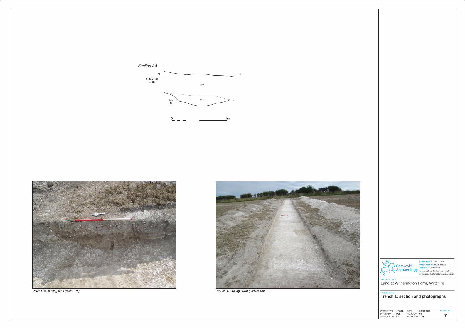
Ditch 110, looking east (scale 1m) Trench 1, looking north (scales 1m)
CotswoldArchaeology
Cirencester 01285 771022
Milton Keynes 01908 218320
Andover 01264 347630
w www.cotswoldarchaeology.co.uk
PROJECT TITLE
FIGURE TITLE
FIGURE NO.DATEREVISIONSCALE@A4
PROJECT NO.DRAWN BYAPPROVED BY
12-09-2014001:20
770098DJBLM 7
Land at Witherington Farm, Wiltshire
Trench 1: section and photographs
109.75mAOD
N
Section AA
S
ditch110
111
100
0 1m
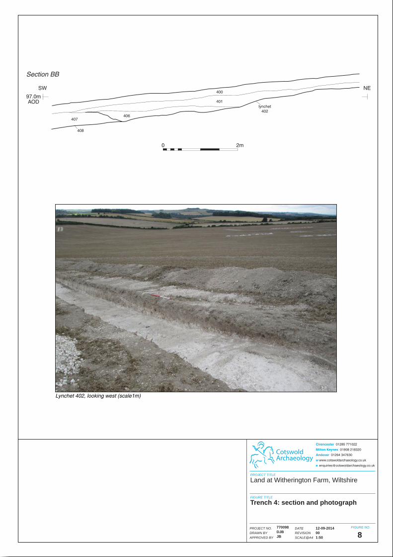
0 2m
97.0mAOD
SW
Section BB
NE400
401
406407
408
lynchet402
Lynchet 402, looking west (scale1m)
12-09-2014001:50
770098DJBJB 8
Land at Witherington Farm, Wiltshire
Trench 4: section and photograph
CotswoldArchaeology
Cirencester 01285 771022
Milton Keynes 01908 218320
Andover 01264 347630
w www.cotswoldarchaeology.co.uk
PROJECT TITLE
FIGURE TITLE
FIGURE NO.DATEREVISIONSCALE@A4
PROJECT NO.DRAWN BYAPPROVED BY

98.5mAOD
SW
Section CC
NE
holloway602
600
601
Possible holloway 602, looking north-west (scale 1m)
12-09-2014001:20
770098DJBJB 9
Land at Witherington Farm, Wiltshire
Trench 6: section and photograph
CotswoldArchaeology
Cirencester 01285 771022
Milton Keynes 01908 218320
Andover 01264 347630
w www.cotswoldarchaeology.co.uk
PROJECT TITLE
FIGURE TITLE
FIGURE NO.DATEREVISIONSCALE@A4
PROJECT NO.DRAWN BYAPPROVED BY
0 1m
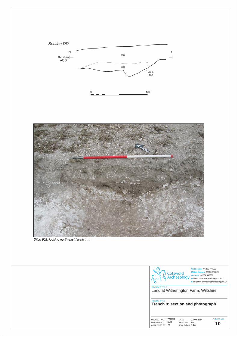
87.75mAOD
N
Section DD
S
ditch902
900
903
Ditch 902, looking north-east (scale 1m)
12-09-2014001:20
770098DJBJB 10
Land at Witherington Farm, Wiltshire
Trench 9: section and photograph
CotswoldArchaeology
Cirencester 01285 771022
Milton Keynes 01908 218320
Andover 01264 347630
w www.cotswoldarchaeology.co.uk
PROJECT TITLE
FIGURE TITLE
FIGURE NO.DATEREVISIONSCALE@A4
PROJECT NO.DRAWN BYAPPROVED BY
0 1m

1000
1003holloway1002
95.25mAOD
SW
Section EE
NE
Holloway 1002, looking north-west (scale 1m)
12-09-2014001:20
770098DJBJB 11
Land at Witherington Farm, Wiltshire
Trench 10: section and photograph
CotswoldArchaeology
Cirencester 01285 771022
Milton Keynes 01908 218320
Andover 01264 347630
w www.cotswoldarchaeology.co.uk
PROJECT TITLE
FIGURE TITLE
FIGURE NO.DATEREVISIONSCALE@A4
PROJECT NO.DRAWN BYAPPROVED BY
0 1m

0 2m
84.0mAOD
N
Section FF
S
1403
1400
lynchet1402
Lynchet 1402, looking north-east (scale 1m)
12-09-2014001:50
770098DJBJB 12
Land at Witherington Farm, Wiltshire
Trench 14: section and photograph
CotswoldArchaeology
Cirencester 01285 771022
Milton Keynes 01908 218320
Andover 01264 347630
w www.cotswoldarchaeology.co.uk
PROJECT TITLE
FIGURE TITLE
FIGURE NO.DATEREVISIONSCALE@A4
PROJECT NO.DRAWN BYAPPROVED BY

Lynchet 1703, looking west (scale 1m) Trench 17, looking north (scales 1m)
CotswoldArchaeology
Cirencester 01285 771022
Milton Keynes 01908 218320
Andover 01264 347630
w www.cotswoldarchaeology.co.uk
PROJECT TITLE
FIGURE TITLE
FIGURE NO.DATEREVISIONSCALE@A4
PROJECT NO.DRAWN BYAPPROVED BY
12-09-2014001:20
770098DJBLM 13
Land at Witherington Farm, Wiltshire
Trench 17: sections and photographs
84.5mAOD
SW
Section HH
NE
posthole1707
1708
84.75mAOD
N
Section GG
W
lynchet1703
1706
0 1m
0 1m
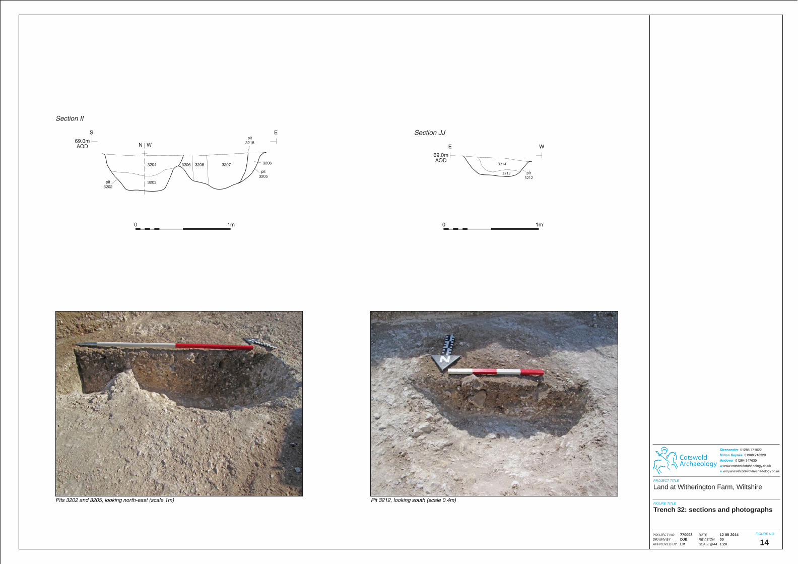
Pits 3202 and 3205, looking north-east (scale 1m) Pit 3212, looking south (scale 0.4m)
CotswoldArchaeology
Cirencester 01285 771022
Milton Keynes 01908 218320
Andover 01264 347630
w www.cotswoldarchaeology.co.uk
PROJECT TITLE
FIGURE TITLE
FIGURE NO.DATEREVISIONSCALE@A4
PROJECT NO.DRAWN BYAPPROVED BY
12-09-2014001:20
770098DJBLM 14
Land at Witherington Farm, Wiltshire
Trench 32: sections and photographs
69.0mAOD
S
Section II
E
3204 3206 32063208 3207
3203
pit3205
pit3202
pit3218N W
3214
3213 pit3212
69.0mAOD
E
Section JJ
W
0 1m 0 1m

81.0mAOD
E
Section KK
W
3600
3603
ditch3602
Ditch 3602, looking south (scale 1m)
12-09-2014001:20
770098DJBJB 15
Land at Witherington Farm, Wiltshire
Trench 36: section and photograph
CotswoldArchaeology
Cirencester 01285 771022
Milton Keynes 01908 218320
Andover 01264 347630
w www.cotswoldarchaeology.co.uk
PROJECT TITLE
FIGURE TITLE
FIGURE NO.DATEREVISIONSCALE@A4
PROJECT NO.DRAWN BYAPPROVED BY
0 1m

74.0mAOD
SW
Section LL
NE
3704
3701
3700
ditch3703
Ditch 3703, looking north-west (scale 1m)
12-09-2014001:20
770098DJBJB 16
Land at Witherington Farm, Wiltshire
Trench 37: section and photograph
CotswoldArchaeology
Cirencester 01285 771022
Milton Keynes 01908 218320
Andover 01264 347630
w www.cotswoldarchaeology.co.uk
PROJECT TITLE
FIGURE TITLE
FIGURE NO.DATEREVISIONSCALE@A4
PROJECT NO.DRAWN BYAPPROVED BY
0 1m

67.75mAOD
SE
Section MM
NW
pit3804
3806
3805
Pit 3804, looking south-west (scale 0.4m)
12-09-2014001:20
770098DJBJB 17
Land at Witherington Farm, Wiltshire
Trench 38: section and photograph
CotswoldArchaeology
Cirencester 01285 771022
Milton Keynes 01908 218320
Andover 01264 347630
w www.cotswoldarchaeology.co.uk
PROJECT TITLE
FIGURE TITLE
FIGURE NO.DATEREVISIONSCALE@A4
PROJECT NO.DRAWN BYAPPROVED BY
0 1m

85.5mAOD
W
Section NN
E
ditch4204
4205
4206
Ditch 4204, looking south (scale 0.4m)
12-09-2014001:20
770098DJBJB 18
Land at Witherington Farm, Wiltshire
Trench 42: section and photograph
CotswoldArchaeology
Cirencester 01285 771022
Milton Keynes 01908 218320
Andover 01264 347630
w www.cotswoldarchaeology.co.uk
PROJECT TITLE
FIGURE TITLE
FIGURE NO.DATEREVISIONSCALE@A4
PROJECT NO.DRAWN BYAPPROVED BY
0 1m
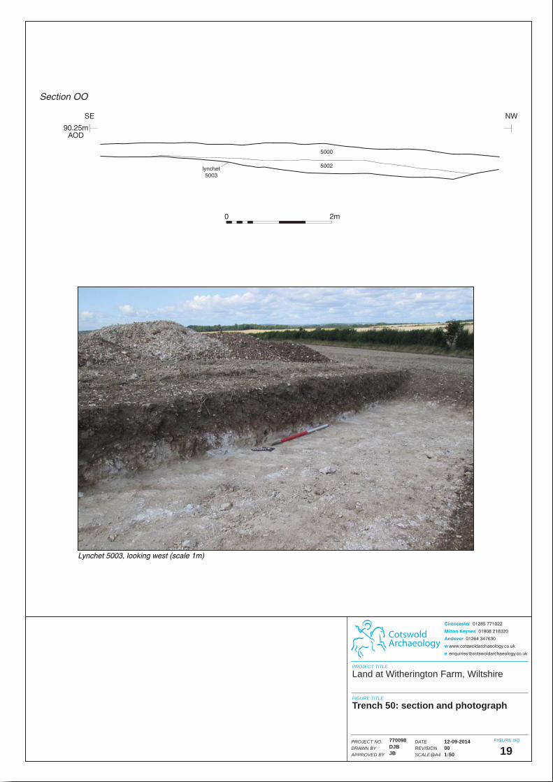
0 2m
5000
5002lynchet5003
90.25mAOD
SE
Section OO
NW
Lynchet 5003, looking west (scale 1m)
12-09-2014001:50
770098DJBJB 19
Land at Witherington Farm, Wiltshire
Trench 50: section and photograph
CotswoldArchaeology
Cirencester 01285 771022
Milton Keynes 01908 218320
Andover 01264 347630
w www.cotswoldarchaeology.co.uk
PROJECT TITLE
FIGURE TITLE
FIGURE NO.DATEREVISIONSCALE@A4
PROJECT NO.DRAWN BYAPPROVED BY