archaeological evaluation report: trial trenching …
TRANSCRIPT
ARCHAEOLOGICAL EVALUATION REPORT:
TRIAL TRENCHING AT THE GRIMSBY INSTITUTE, NUNS CORNER, GRIMSBY,
NORTH-EAST LINCOLNSHIRE
Planning Reference: N/A NGR: TA 2648 0804 Site Code: GRIN 08
North-East Lincolnshire Museum Accession Number: GRIM.2008.13
Report prepared for CDC Architecture Limited
On behalf of The Grimsby Institute
AAA Report Number 2008/033
June 2008
Allen Archaeological Associates Unit 1C, Branston Business Park
Lincoln Road Branston
Lincolnshire LN4 1NT
Tel/Fax: 01522 794400 E-mail: [email protected]
Website: www.allenarchaeology.co.uk

Contents
Summary 1 1.0 Introduction 2 2.0 Site location and description 2 3.0 Planning background 2 4.0 Archaeological and historical background 2 5.0 Methodology 4 6.0 Results 4 6.1 Trench 1 4 6.2 Trench 2 5 7.0 Discussion and conclusion 6 8.0 Effectiveness of methodology 7 9.0 Acknowledgements 7 10.0 References 8 11.0 Site archive 8
Appendices Appendix 1: Colour plates 9 Appendix 2: Post-Roman pottery and fired clay assessment 11 Appendix 3: Animal bone assessment 14 Appendix 4: Context summary list 15

List of Figures Figure 1: Location of site with the college outlined in red, at scale 1:25,000 Figure 2: Site location plan, with the college grounds outlined in red and the two trenches shown in blue (scale 1:2500) Figure 3: Trench location plan with archaeological features shown in solid black at scale 1:500. The proposed new development is outlined in red. Figure 4: Trench 1 plan and main section at scale 1:50, with C-D section at scale 1:20 Figure 5: Trench 2 plan and main section at scale 1:50 and sections C-D and E-F at scale 1:20
List of Plates Plate 1: The development area, looking north-west. Plate 2: Trench 1, pre-excavation, looking north-west. Plate 3: Ditches [106] and [108], north-west end of Trench 1, looking north-east. Plate 4: Ditches [112] and [118], Trench 1, looking north-east. Plate 5: Trench 2 pre-excavation, looking north. Plate 6: Ditch [204], north end of Trench 2, looking east.
Document Control
Element Name Date Report prepared by: Chris Clay and Mike Daley 30/05/2008 Illustrations prepared by: Maria Piirainen 28/05/2008 Report edited by: Mark Allen 30/05/2008 Report produced by: AAA 2008/033 02/06/2008
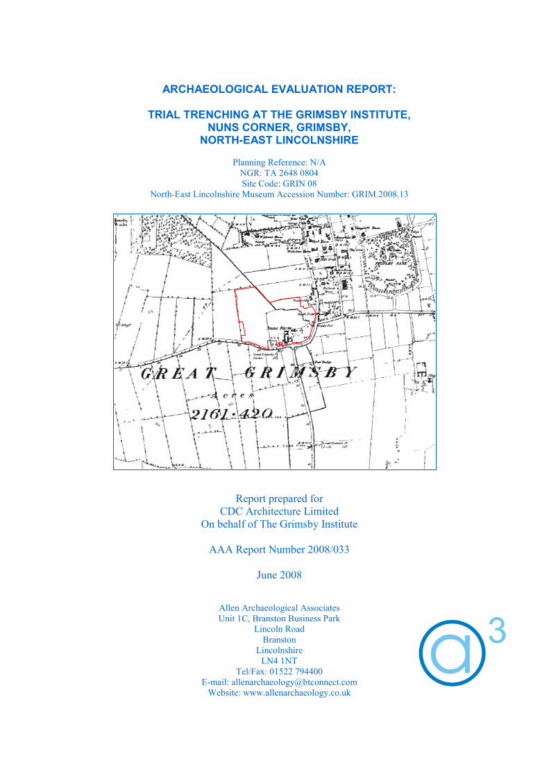
Cover image: 1890 Ordnance Survey map of Grimsby, with the college grounds outlined in red

North-East Lincolnshire Museums Service Accession Number GRIM 2008.13
1
Summary
• An archaeological evaluation by trial trenching was carried out in advance of an extensive programme of redevelopment at the Grimsby Institute, Nun’s Corner, Grimsby, North-East Lincolnshire.
• The site is believed to lie in the vicinity of the 12th century Augustinian priory of St. Leonard’s. In the
19th century, much of the area was used for the dumping of domestic waste from Grimsby.
• Two trenches were excavated within the proposed development area, exposing a series of features of possibly late Saxon and 12th to 13th century date, sealed beneath a substantial flood horizon of late medieval/post-medieval date. This clay layer was overlain by a spread of Victorian refuse.
Figure 1: Location of site with the college outlined in red, at scale 1:25,000 ©Crown Copyright 2006. All rights reserved. License No 100047330
The Site

North-East Lincolnshire Museums Service Accession Number GRIM 2008.13
2
1.0 Introduction 1.1 Allen Archaeological Associates was commissioned by CDC Architecture Ltd, on behalf of the
Grimsby Institute, to carry out an archaeological evaluation by trial excavation within the grounds of The Grimsby Institute, Nuns Corner in Grimsby, North-East Lincolnshire.
1.2 The site works and reporting conform to current national guidelines, as set out in Planning Policy
Guidance Note 16 (Department of the Environment 1990), Management of Archaeological Projects (Andrews 1991), and the Institute for Field Archaeologists ‘Standards and guidance for archaeological evaluations’ (IFA 2001).
1.3 The archive will be submitted to North-East Lincolnshire Museums Service within six months of
the completion of the report.
2.0 Site location and description 2.1 Grimsby lies on the coast of the administrative district of North-East Lincolnshire, and on the
southern bank of the Humber Estuary. The site is situated to the south-west of the town centre, off Bargate and Laceby Road. The area of works is within area of landscaped grounds, to the south of the Bargate entrance to the college, and east of the college sports hall.
2.2 The site centres on NGR TA 2648 0804, and lies on predominantly flat ground at an OD height of
approximately 7m. The local geology consists of drift deposits of Glacial Till, overlying a solid geology of Cretaceous Flamborough Chalk (British Geological Survey 1990).
3.0 Planning background 3.1 A planning application will shortly be submitted for a major redevelopment of the college
grounds, involving the demolition and rebuilding of much of the existing college. As the site lies in an area of potential archaeological significance, it was requested that a programme of archaeological evaluation by trial trenching was undertaken prior to the submission of the planning application, in order to more accurately determine the archaeological potential of the proposed development area.
4.0 Archaeological and historical background 4.1 There is little evidence for prehistoric activity in the vicinity of the site, although numerous
scatters of Mesolithic and Neolithic flint implements have been recovered from the wider area, predominantly located within riverine locations along the banks of the River Freshney, Buck Beck and along the coastal plain (Ellis et al 2001).
4.2 Evidence for funerary activity in the Bronze Age in the surrounding area is noted, with round
barrow burial monuments recorded at Toothill and Bourne Lane in Grimsby, and Beacon Hill in Cleethorpes (Wise 1990).
4.3 A thriving economy, possibly with continental trading links, is well attested in the Iron Age with
gold coin hoards including four Gallo-Belgic imported coins from Bargate, two Gallo-Belgic E imports and four British coins from Scartho, and a single Corieltauvian coin from Beacon Hill (ibid).
4.4 An Iron Age settlement excavated from 1976 until 1990 at Weelsby Avenue in Grimsby revealed
evidence for a mixed farming economy that was replaced by a specialist manufacturing industry,

North-East Lincolnshire Museums Service Accession Number GRIM 2008.13
3
focussed upon the production of high status harness fittings. The significance of this site may be demonstrated by it yielding the second largest volume of Iron Age bronze casting debris in England (Sills 2001).
4.5 Little in the way of excavated evidence has been recorded for the Romano-British period in this
area, although a broad range of artefactual evidence has been recovered, including a large pottery assemblage dating from the 2nd to 4th centuries AD from Peakes Lane, c. 1km to the east of the site (Whitwell 1982).
4.6 Grimsby is traditionally considered to have been founded during the Anglo-Scandinavian period.
The account of Geoffrey Gaimar, a 12th century writer, attests to the existence of a settlement by chronicling the crossing of the Danes to Grimsby on their way to York in AD 866 (Wise 1990). The place name also suggests development in this period, as it comes from the Old Norse, meaning Grimr’s farm or settlement (Cameron 1998).
4.7 Grimsby appears in the Domesday Survey of 1086, under the control of three major landowners;
the Bishop of Bayeux, Drogo of La Beuvrière and Ralph of Mortimer (Morgan and Thorn 1986). The town also appears in the Orkneyinga Saga of c.1200, in the phrase ‘i grims bæ mithivm’ meaning ‘in the middle of Grimsby’ (Pálsson and Edwards 1981).
4.8 The town developed in the medieval period as a major port with important trade links with
Scandinavia, with a particular emphasis on the trade of fish. The gradual silting of the natural haven and competition from the emerging ports of Boston and Hull caused serious decline in the 14th and 15th centuries however (Ambler 1990).
4.9 The proposed development area is believed to be located within the boundaries of the medieval
priory of St Leonard’s. Excavations in 1962 on the college grounds revealed burials, pottery and architectural fragments likely to be associated with the priory. St. Leonard’s was an Augustinian nunnery, built before 1184 (probably by Henry II), and occupied until its closure during the dissolution of 1539. It was a relatively small and poor establishment; in 1296 the nuns had to beg for alms to support themselves, and in 1297 certain men were excommunicated for an unjust distraint, or recovery of rent arrears, upon their property. Another licence to beg was granted in 1311, on the ground that their houses and corn had been consumed by fire. In 1394 they were excused from payment of a subsidy at the bishop's request, on account of their poverty. A further licence to beg was granted in 1459, as not only had their buildings been burnt again, but their land inundated by floodwaters (Page 1906).
4.10 The late medieval decline in Grimsby continued until the development of a new dock in 1800 to
encourage seaborne trade, with the arrival of the railway in 1846 inspiring further growth (Ambler 1990).
4.11 Cartographic evidence provided by the 1890 First Edition Ordnance Survey map of Grimsby (see
front cover) shows that urban expansion had not yet reached the development area. The map shows the site to be open ground, with Nun’s Farm shown to the north of Bargate at its junction with Scartho Road.
4.12 Previous archaeological interventions in the college grounds have shown that the area was used as
a landfill site for the expanding town, with substantial dumps of up to 0.7m of 19th/20th century domestic waste being recorded (Allen 2006, Clay 2006).

North-East Lincolnshire Museums Service Accession Number GRIM 2008.13
4
5.0 Methodology 5.1 The trial excavation methodology entailed the excavation of two trenches in locations specified
by the Archaeologist at North-East Lincolnshire Council (Figures 2 and 3). Trench 1 was 20m long by 1.6m wide and Trench 2 was 10m long by 1.6m wide.
5.2 Machine excavation was carried out using a 3CX JCB excavator fitted with a 1.6m wide toothless
dykeing bucket. Modern topsoil and overburden was removed in layer not exceeding 0.1m in depth, under close archaeological supervision, until the first archaeologically significant horizon was exposed. All further excavation was then carried out by hand.
5.3 Archaeological features were sample excavated in order to determine their depth, profile,
orientation and where possible, date and function. A full written record of all archaeological features and deposits was made on Allen Archaeological Associates context record sheets, accompanied by plan and section drawings at appropriate scales (1:50 and 1:20). A full colour photographic record was maintained, and selected prints have been included as an appendix to this report (Appendix 1). The fieldwork was carried out by the author, with the assistance of one experienced field archaeologist over a period of three days, Tuesday 13th to Thursday 15th May 2008.
6.0 Results 6.1 Trench 1 (Figure 4)
6.1.1 The uppermost deposit was a modern topsoil horizon, 100, that was between 0.3 and 0.6m deep and represented the modern landscaping of the college grounds. It sealed 101, a 0.1 to 0.2m deep layer of dark brown/grey silty clay with frequent ceramic building material, chalk fragments and 19th/20th glass bottles, pottery and other domestic detritus. This deposit represents the recent use of the area as a landfill site, identified at other localities within the college grounds (Allen 2006, Clay 2006).
6.1.2 Below 101 was 102, a compact grey/brown clay. The deposit was between 0.3m and 0.85m deep,
and was at its deepest towards the centre of the trench, over a slight natural hollow (see Section 6.1.3 below). It was archaeologically sterile and was interpreted as an alluvial deposit.
6.1.3 102 sealed a buried topsoil, 103, and underlying subsoil 104, both of which slumped into a slight
hollow in the underlying natural clay, 105, at the centre of the trench. 6.1.4 104 sealed a series of linear features and pits that were cut into the natural clay. At the north-west
end of the trench, ditch [106] ran on a broadly east – west alignment, and had moderately sloping sides and a concave base. It was filled by an undated natural silting deposit, 107, of dark grey/brown silty clay.
6.1.5 To the south-east, ditch [106] cut a steep-sided linear feature, [108], which was aligned north-east
to south-west. It also was undated and was filled by a silting deposit of mid brown/grey silty clay, 109. Towards the west side of the trench, the ditch was cut by a large sub-circular feature, [110], probably representing part of a large pit or pond, the remainder of which lay beyond the limit of excavation. The section exposed measured 7.5m by 0.85m and was 0.12m deep. The fill was an undated natural silting deposit of very dark grey/brown silty clay, 111.
6.1.6 Further to the south-east [110] cut two further intercutting linear features, [112] and [118]. The
earlier of the two ditches, [118], was approximately 1.5m wide and 0.65m deep, with a moderately steep bowl-shaped profile, and it was aligned north-east to south-west. The primary fill, 120, was a dark brown/grey silty clay, representing natural silting. It was sealed by a mixed

North-East Lincolnshire Museums Service Accession Number GRIM 2008.13
5
deposit, 119, comprising grey/brown silty clay mottled with yellow/brown clay. The mixed nature of the deposit suggests that it may represent a deliberate backfilling event.
6.1.7 The north-west side of [118] was cut by [112], which also ran on a broadly north-east to south-
west alignment. The profile of the ditch varied along its excavated length, from a steep-sided V-shape at the north-eastern baulk, to a steep-sided profile with a wider, flatter base further to the south-west. It was filled by a silting deposit of grey/brown silty clay, 113. Both ditches [112] and [118] were undated.
6.1.8 Towards the south-east end of the trench, a narrow steep-sided linear feature, [115] ran on an east
– west alignment. The possible beam-slot was filled by a natural silting deposit, 117 which was undated. At the south-western side of the trench, it intersected a shallow irregular pit, [114], which was also undated, but contained two animal bone fragments and a fragment of fish bone. The similarity of the fills of the two features made it impossible to determine a stratigraphic relationship.
6.2 Trench 2 (Figure 5)
6.2.1 The topsoil in this trench was a 0.5 to 0.75m deep dark brown silty clay, 200, representing the modern landscaping of the college grounds. It sealed 201, a dumped deposit of black and dark brown silty clay with abundant early modern glass and ceramic vessels, scrap metal and brick and tile fragments. This deposit was up to 0.45m deep, and represented the ubiquitous 19th/20th century landfill deposit.
6.2.2 Below 201 was 202, a 0.1 to 0.3m deep grey/brown silty clay representing a possible former
subsoil. This deposit sealed the natural geology, 203, an orange/brown clay, which was cut by a number of small pits and linear features.
6.2.3 At the north end of the trench, one side of a ditch was exposed, running east – west and curving
slightly to an east-north-east to west-south-west alignment at the east side of the trench, [204]. The feature had a moderately steep southern edge and a flat base, and contained a single fill of dark grey/brown silty clay, 205. The fill produced three pottery sherds of 12th to early 13th century date, two fragments of fired clay, five animal bone fragments, eight fish bone fragments and two pieces of oyster shell.
6.2.4 To the south of ditch [204], a small sub-rectangular shallow pit, [206] was excavated against the
eastern limit of excavation. It survived to a depth of 0.1m and had very shallow sides and a concave base. The fill, 207, was an undated brown/grey silty clay.
6.2.5 Towards the south end of the trench was another small pit-like feature, [208]. It was roughly
circular, with a diameter of c.0.25m. The feature had shallow sloping sides, with a sharp break of slope to a very steep pointed base, 0.14m deep. The profile of the feature suggested that it was a void for a wooden stake. It contained an undated fill of brown/grey silty clay, 209, which contained a single fragment of pig femur.
6.2.6 Immediately to the south of [208] was a small gully or elongated pit, [210]. It was 0.3m wide and
extended 0.55m from the western edge of the trench, ending with a semi-circular terminus. It was very shallow, surviving to only 0.08m deep, and contained a natural silting deposit of grey/brown silty clay, from which a single sherd of 9th/10th century Lincoln Shelly Ware was recovered.

North-East Lincolnshire Museums Service Accession Number GRIM 2008.13
6
7.0 Discussion and conclusion
7.1 The scheme of archaeological evaluation has demonstrated the presence of archaeological features within both of the excavated trenches. The earliest activity on the site is represented by a single small sherd of pottery of late Saxon date (9th/10th century). This was recovered from the small pit or ditch [210], at the south end of Trench 2. The function of the feature is unclear therefore the nature of the activity represented is unknown; although the presence of Late Saxon pottery on the site is significant, as it represents the first evidence of activity of this period in the vicinity of the site.
7.2 At the north end of Trench 2, ditch [204] produced three sherds of pottery indicating a 12th to
early 13th century date for the feature. This potentially makes the feature contemporary with the priory of St. Leonard’s, which is believed to have been established in the vicinity of the site towards the end of the 12th century (Page 1906). As a note of caution however, the date range for the pottery makes it equally possible that the ditch represents a land division or property boundary that pre-dates the foundation of the priory. It is possible, though not certain, that the same ditch is represented by [106] in Trench 1.
7.3 A further series of ditches were identified in Trench 1. None of the ditches produced any dating
evidence, although stratigraphic relationships provided a relative sequence. Towards the north end of the trench, ditch [108] was cut by ditch [106]. It is has been suggested that [106] is the same feature as [204] in Trench 2 which produced early medieval pottery, which would indicate an earlier date for [108]. However, this interpretation is far from certain.
7.4 South-east of [108], ditch [118] was cut by [112]. It contained an initial natural silting deposit,
sealed by a probable backfill deposit. It is possible that the feature was backfilled immediately prior to the excavation of the adjacent ditch [112], representing a slight realignment of an existing boundary. Based on a shared alignment, it is also plausible that either [112] or [118] are broadly contemporary with [108].
7.5 Ditches [108], [112] and [118] were all cut by a large sub-circular feature, [110]. The function
and date of the feature were unclear, although it may represent a large pond, the majority of which extends beyond the limit of excavation to the south-west.
7.6 Possible structural elements were identified during the evaluation, comprising possible beam slot
[115] in Trench 1, and posthole [208] in Trench 2. Without associated features or dating evidence however, these features offer little interpretative potential.
7.7 The general lack of dating evidence and other artefacts from the site suggests that the features
were located away from the centre of any contemporary settlement activity, in areas not habitually used for the disposal of domestic or industrial waste. Instead, they may be associated with agricultural processes.
7.8 All the features were sealed by a considerable depth of overburden, particularly in Trench 1.
Immediately overlying the features, a subsoil and topsoil had formed after the silting up and abandonment of these features. This in turn lay beneath a thick layer of sterile clay, interpreted as an alluvial horizon. Documentary evidence suggests flooding of the area in 1459, when the nuns of St. Leonard’s were given license to beg on account of flooding of their estates, and it is possible that this flood event is represented by the clay layer (Page 1906).
7.9 This scenario fits well with the wider historical context of the area. Grimsby was suffering a
serious decline in the 14th and 15th centuries, partially due to the gradual silting of The Haven which restricted sea access to the town (Ambler 1990). A further consequence of the silting of The Haven was that it would have impeded the outflow of local rivers into the sea, therefore encouraging overbank flooding onto the surrounding land. The depth of the alluvial deposit on the
North-East Lincolnshire Museums Service Accession Number GRIM 2008.13
7
site (up to 0.85m) indicates that it formed over a long period of time and that at some stage after the 12th to 13th century the area was inundated and remained submerged or frequently flooded marshland, usable for little more than seasonal grazing. This situation may have persisted until the diversion of the River Freshney through Grimsby to The Haven at the beginning of the 18th century to improve the flow and provide fresh water (Ambler 1990).
7.10 The presence of this medieval and later flood horizon would suggest that the underlying features
recorded in the two trenches all predate this period of flooding, and are likely to be of a broadly similar date to the features dated by ceramic evidence to the late Saxon and early medieval periods, although the lack of dating evidence from the majority of the features makes closer dating impossible.
7.11 In the 19th century, the site was used as a dumping ground for waste from Grimsby, and evidence
of this was recorded overlying the flood horizon in both trenches. This deposit was significantly deeper in Trench 2, and had a greater density of domestic waste, comprising glass bottles, pottery, brick and tile, wood, leather shoe fragments, and metal objects such as pots, pans and kettles, all of 19th and 20th century date. Archaeological watching briefs within the college grounds to the north of the current programme of fieldwork have shown that this deposit extends over much of the area, and is up to 0.7m deep in places (Allen 2006, Clay 2006). It is quite probable that this depth of material has allowed for the preservation of earlier features and deposits within the college grounds, which relate to the documented medieval priory and possibly earlier activity.
8.0 Effectiveness of methodology 8.0 This scheme of archaeological investigation has identified a complex of features and deposits of
late Saxon and later date within the proposed development area, although the most significant finds and features are buried at some depth below the existing ground surface. The evaluation has provided sufficient evidence to inform the planning process and allow for appropriate mitigation strategies to be established, if required.
9.0 Acknowledgements 9.1 Allen Archaeological Associates would like to thank CDC Architecture and their client, The
Grimsby Institute for this commission. Thanks also go to the staff and students of Grimsby Institute for their co-operation during the fieldwork.

North-East Lincolnshire Museums Service Accession Number GRIM 2008.13
8
10.0 References Allen, M., 2006, Archaeological watching brief report during construction of an extension at the Refectory, Nuns Corner, the Grimsby Institute, Grimsby, North-East Lincolnshire, Allen Archaeological Associates Ambler, R.W., 1990, ‘Historical Development of Grimsby and Cleethorpes’, in Ellis, S. and Crowther, D. R., (eds.), Humber Perspectives: a region through the ages, pp, 227-249. Hull University Press, Hull Andrews, G., 1991, Management of archaeological projects, English Heritage, London British Geological Survey, 1990, England and Wales 1:50,000 Provisional Series, Solid and Drift Edition. Sheet 90/91: Grimsby, British Geological Survey, Keyworth
Cameron, K., 1998, A Dictionary of Lincolnshire Place-names, English Place-Name Society, University of Nottingham, Nottingham Clay, C., 2006, Archaeological watching brief report. Extension to motor vehicle workshop, Grimsby Institute, Grimsby, North-East Lincolnshire, Allen Archaeological Associates Ellis, S. and Crowther, D.R. (eds.), 1990, Humber Perspectives: a region through the ages, Hull University Press, Hull Ellis S., Fenwick, H., Lillie, M., and Van de Noort, R., 2001, Wetland Heritage of the Lincolnshire Marsh, An Archaeological Survey. Humber Wetlands Project, Wetland Archaeology and Environments Research Centre, University of Hull. I.F.A., 1999, Standards and Guidance for archaeological field evaluations, Institute of Field Archaeologists, Reading Morgan, P. and Thorn, C. (eds.), 1986, Domesday Book: vol.31: Lincolnshire, Phillimore & Co. Ltd, Chichester Pálsson, H. and Edwards, P., 1981, Orkneyinga Saga: The History of the Earls of Orkney, Penguin, Harmondsworth Page, W. (ed.), 1906, The Victoria History of the Counties of England, Lincolnshire vol II. Dawson, For the London Institute of Historical Research, London
Sills, J., 2001, ‘Weelsby Avenue, Grimsby’, in (eds.) Ellis S., Fenwick, H., Lillie, M., and Van de Noort R., Wetland heritage of the Lincolnshire Marsh, An Archaeological Survey. Humber Wetlands Project, Wetland Archaeology and Environments Research Centre, University of Hull, Hull Whitwell, J.B, 1992, Roman Lincolnshire, History of Lincolnshire Committee, Lincoln Wise, P. J., 1990, ‘The Archaeology of the Grimsby and Cleethorpes Area’, in Ellis, S. and Crowther, D. R., (eds.) Humber Perspectives: a region through the ages, pp, 213-226. Hull University Press, Hull
11.0 Site archive 11.1 The documentary and physical archive is currently in the possession of Allen Archaeological
Associates. It will be submitted to North-East Lincolnshire Museums Service within six months, and can be accessed using the Global Accession Number GRIM 2008.13.

North-East Lincolnshire Museums Service Accession Number GRIM 2008.13
9
Appendix 1: Colour plates
Plate 1: The development area, looking north-west.
Plate 3: Ditches [106] and [108], north-west end of Trench 1, looking north-east.
Plate 2: Trench 1, pre-excavation, looking north-west.

North-East Lincolnshire Museums Service Accession Number GRIM 2008.13
10
Plate 4: Ditches [112] and [118], Trench 1, looking north-east.
Plate 6: Ditch [204], north end of Trench 2, looking east.
Plate 5: Trench 2 pre-excavation, looking north.

North-East Lincolnshire Museums Service Accession Number GRIM 2008.13
11
Appendix 2: Post-Roman pottery and fired clay assessment By Anne Boyle Introduction All the material was recorded at archive level in accordance with the guidelines laid out in Slowikowski et al. 2001 and to conform to Lincolnshire County Council's Archaeology Handbook. The pottery codenames (Cname) are in accordance with the Post Roman pottery type series for Lincolnshire, as published in Young et al. 2005. Four sherds from four vessels, weighing 20 grams were recovered from the site.
Methodology The material was laid out and viewed in context order. Sherds were counted and weighed by individual vessel within each context. The pottery was examined visually and using x20 magnification. This data was then added to an Access database. An archive list of the pottery is included in table 1. The pottery ranges in date from the Late Saxon to the Early Medieval period.
Condition The sherds are small but in fairly fresh condition; the average sherd weight is five grams. Three of the sherds have signs of soot suggesting they were used over a hearth or fire.
Results Table 1, Post Roman Pottery Archive
Cxt Cname Full name Fabric Form NoS NoV W (g) Part Description205 ELQC East Lincolnshire Quartz
and Chalk 1 Jar? 1 1 3 BS
205 ELQC East Lincolnshire Quartz and Chalk
1 Jar? 1 1 4 BS Soot
205 WEMS Wheel thrown Early Medieval Shell-tempered ware
Reduced; Fine Shell
Jar/bowl
1 1 3 Base Soot
211 LSH Lincoln Shelly ware Bowl 1 1 10 Base Soot; white internal deposit; leached; fe slip
Provenance Three vessels are associated with the fill of Ditch [204] are probably residual as they are all represented by single sherds. A single leached Late Saxon sherd came from Linear [211].
Range East Lincolnshire Quartz and Chalk (ELQC) and Wheel thrown Early Medieval Shell-tempered wares (WEMS) are known from other excavations in this area. The Late Saxon sherd comes from a Lincoln Shelly ware bowl.
Potential The pottery poses no problems for long term storage and should be retained. The assemblage does not require further work, although the pottery should be reassessed in light of further work at the site.

North-East Lincolnshire Museums Service Accession Number GRIM 2008.13
12
Summary A small assemblage of pottery was recovered from two contexts. The pottery suggests activity in the vicinity of the site during the Late Saxon and Early Medieval periods, although the assemblage is too small to draw any further conclusions.
FIRED CLAY
Introduction All the material was recorded at archive level in accordance with the guidelines laid out in the Lincolnshire County Council's Archaeology Handbook.
Methodology The material was laid out and viewed in context order. Fragments of fired clay were counted and weighed within each context. This data was then added to an Access database. An archive list of the fired clay is included in table 2.
Condition The fragments are small and abraded.
Results Table 2, Fired Clay Archive
Cxt Fabric NoF W (g) Description
205 Oxidised; fine sandy 1 5 Possible flat surface; CBM? 205 Reduced; fine sandy 1 6 Organic impressions; possible mould
Provenance Both fragments came from (205), fill of Ditch [204].
Potential The assemblage should be retained; no further work is required.
Summary Two small fragments of fired clay were recovered from the site. The poor condition of the material prevents interpretation of the assemblage.
SPOT DATING The dating in table 3 is based on the evidence provided by the finds detailed above.
Table 3, Spot dates Cxt Date Comments
205 12th to early 13th 211 Late 9th to 10th Date on a single sherd

North-East Lincolnshire Museums Service Accession Number GRIM 2008.13
13
ABBREVIATIONS BS Body sherd CBM Ceramic Building Material CXT Context NoF Number of Fragments NoS Number of sherds NoV Number of vessels W (g) Weight (grams)
REFERENCES ~ 2003, Lincolnshire Archaeological Handbook [internet]. Available at <http://www.lincolnshire.gov.uk/ section.asp?catId=3155> Slowikowski, A. M., Nenk, B., and Pearce, J., 2001, Minimum Standards for the Processing, Recording, Analysis and Publication of Post-Roman Ceramics, Medieval Pottery Research Group Occasional Paper 2 Young, J., Vince, A.G. and Nailor, V., 2005, A Corpus of Saxon and Medieval Pottery from Lincoln (Oxford)
North-East Lincolnshire Museums Service Accession Number GRIM 2008.13
14
Appendix 3: Animal bone assessment By Jennifer Wood
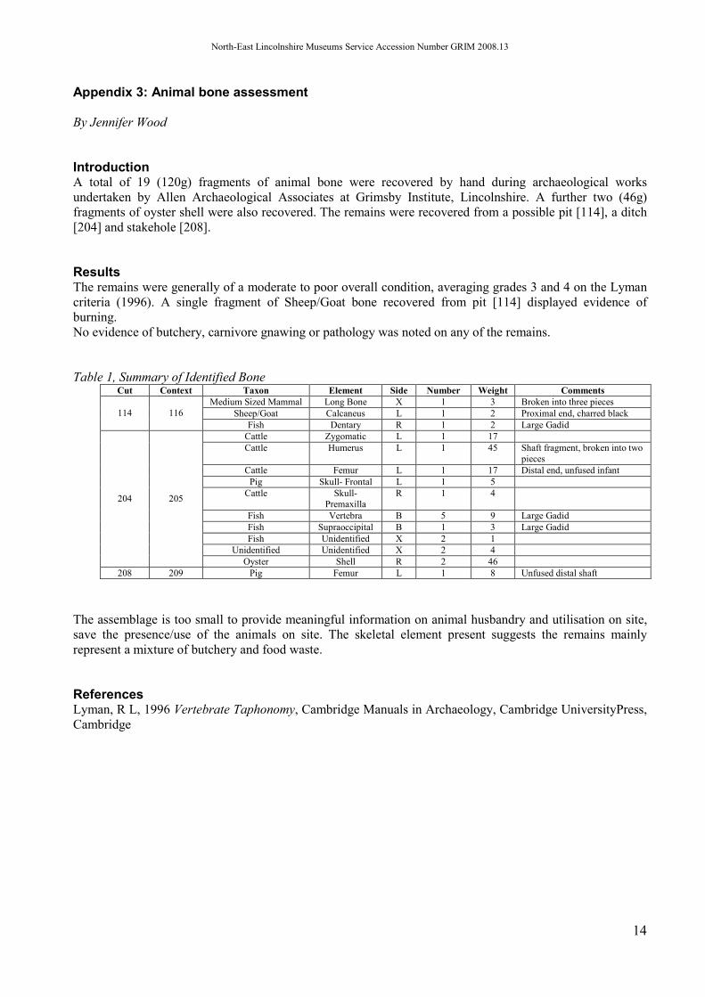
Introduction A total of 19 (120g) fragments of animal bone were recovered by hand during archaeological works undertaken by Allen Archaeological Associates at Grimsby Institute, Lincolnshire. A further two (46g) fragments of oyster shell were also recovered. The remains were recovered from a possible pit [114], a ditch [204] and stakehole [208].
Results The remains were generally of a moderate to poor overall condition, averaging grades 3 and 4 on the Lyman criteria (1996). A single fragment of Sheep/Goat bone recovered from pit [114] displayed evidence of burning. No evidence of butchery, carnivore gnawing or pathology was noted on any of the remains.
Table 1, Summary of Identified Bone Cut Context Taxon Element Side Number Weight Comments
Medium Sized Mammal Long Bone X 1 3 Broken into three pieces Sheep/Goat Calcaneus L 1 2 Proximal end, charred black 114 116
Fish Dentary R 1 2 Large Gadid Cattle Zygomatic L 1 17 Cattle Humerus L 1 45 Shaft fragment, broken into two
pieces Cattle Femur L 1 17 Distal end, unfused infant
Pig Skull- Frontal L 1 5 Cattle Skull-
Premaxilla R 1 4
Fish Vertebra B 5 9 Large Gadid Fish Supraoccipital B 1 3 Large Gadid Fish Unidentified X 2 1
Unidentified Unidentified X 2 4
204 205
Oyster Shell R 2 46 208 209 Pig Femur L 1 8 Unfused distal shaft
The assemblage is too small to provide meaningful information on animal husbandry and utilisation on site, save the presence/use of the animals on site. The skeletal element present suggests the remains mainly represent a mixture of butchery and food waste.
References Lyman, R L, 1996 Vertebrate Taphonomy, Cambridge Manuals in Archaeology, Cambridge UniversityPress, Cambridge

North-East Lincolnshire Museums Service Accession Number GRIM 2008.13
15
Appendix 4: Context summary list Trench 1
Context No.
Type Description Interpretation
100 Layer Firm, dark brownish grey silt clay with moderate chalk fragments, CBM and roots. Seals (101)
Modern topsoil, associated with landscaping of college gardens
101 Layer Firm, dark brownish grey silt clay with frequent CBM, glass and chalk fragments etc. Sealed by (100), seals (102)
Demolition/waste dump layer, same as (201)
102 Layer Firm, greyish brown, silt clay with occasional sub-rounded chalk. Sealed by (101), seals (103)
Possible alluvial deposit, late med/post med. flooding?
103 Layer Firm, dark brownish grey, clay silt. Sealed by (102), seals (104)
Former buried topsoil, predating flood horizon and Victorian landfill
104 Layer Fairly firm, mid greyish brown silt clay. Sealed by (103), seals (107), (111) and (116)
Buried subsoil
105 Layer Firm, mid brownish grey, silt clay with frequent chalk flecks and fragments.
Natural clay layer
106 Cut E-W running ditch, steep sided, moderate break of slope to concave base. Cuts (105), contains (107)
Possibly same ditch as [204] in Trench 2
107 Fill Firm, dark greyish brown, silt clay with rare charcoal fragments and natural stone pebbles. Fill of [106], sealed by (104)
Probable naturally silted fill of ditch
108 Cut NE-SW running ditch, steep sided with concave base. Cuts (105), contains (109)
Cut of ditch, possibly contemporary with ditch [112]
109 Fill Fairly firm, mid brownish grey, silt clay with rare charcoal flecks. Fill of [108], cut by [110]
Probable naturally silted fill of ditch
110 Cut N-S curvilinear feature. Cuts (109) and (113), contains (111)
Possible cut of ditch
111 Fill Firm, mid greyish brown with rare flecks of charcoal and chalk. Sealed by (104), fill of [110]
Fill of curvilinear feature
112 Cut E-W running cut of ditch, steep sided, sharp break of slope to concave base. Contains (113), cuts (119)
Cut of ditch, possibly contemporary with ditch [108]
113 Fill Mid brownish grey, silt clay. Cut by [110], fill of [112]
Naturally silted fill of ditch
114 Cut Irregular in plan. Gradually sloping sides and break of slope to slight concave base.
Cut of possible pit

North-East Lincolnshire Museums Service Accession Number GRIM 2008.13
16
Contains (116), cuts (117) 115 Cut NW-SE cut of possible gully,
moderate sloping sides and break of slope to concave base
Cut of possible gully/beam slot
116 Fill Fairly firm, mid brownish grey silt clay with rare flecks of charcoal and sub-angular flint pebbles. Sealed by (104), fill of [114]
Fill of possible pit
117 Fill Fairly firm, mid greyish brown, silt clay. Cut by [114], fill of [115]
Possible naturally silted fill of gully
118 Cut NE – SW aligned ditch, moderate sloping sides, gradual break of slope to a concave base. Cuts (105), contains (119) and (120)
Cut of possible ditch
119 Fill Firm, mid greyish brown silt clay mixed with natural re-deposit. Cut by [112], fill of ditch [118], seals (120)
Secondary fill of ditch, probable deliberate backfill
120 Fill Firm mid brownish grey, silt clay. Sealed by (119), fill of ditch [118]
Naturally silted primary fill of ditch
Trench 2
Context No.
Type Description Interpretation
200 Layer Compact, dark brownish grey, slit clay with rare CBM fragments and charcoal flecks. Seals 201
Modern topsoil, associated with landscaping of college gardens
201 Layer Coarse, mottled dark orangey/blackish brown sandy silt with frequent glass, pottery, CBM and coke fragments, moderate chalk and bone fragments. Sealed by 200, seals 202
Demolition/waste dump layer, same as (101)
202 Layer Firm, mid greyish brown silt clay with rare flecks of charcoal. Sealed by201, seals: (205), (207), (209) and (211)
Subsoil – same as 104?
203 Layer Firm friable, mid brownish orange silt clay.
Natural silty clay layer
204 Cut NW-SE aligned, shallow ditch. Cuts (203), contains 205
Cut of ditch – possibly same as [106].
205 Fill Fairly firm, dark greyish brown clay silt with moderate bone fragments, rare flecks of charcoal and pottery. Sealed by (202)
Natural silting of [204]
206 Cut NE-SW sub-rectangular shallow pit.
Cut of pit

North-East Lincolnshire Museums Service Accession Number GRIM 2008.13
17
Cuts 203. Contains 207 207 Fill Fairly firm, mid brownish
grey, silt clay with rare charcoal flecks and chalk. Sealed by (202)
Natural silting of pit [206]
208 Cut Circular stake-hole. Cuts 203. Contains 209
Cut of stake-hole
209 Fill Fairly firm, dark brownish grey silt clay with rare flecks of charcoal and bone. Sealed by (202)
Fill of stake-hole [208]
210 Cut Shallow linear feature with eastern terminus. Cuts (203), contains (211)
Shallow linear feature or elongated pit.
211 Fill Loose, mid greyish brown, sandy silt with rare charcoal flecks and pottery. Sealed by 202
Fill of linear feature/pit [210]
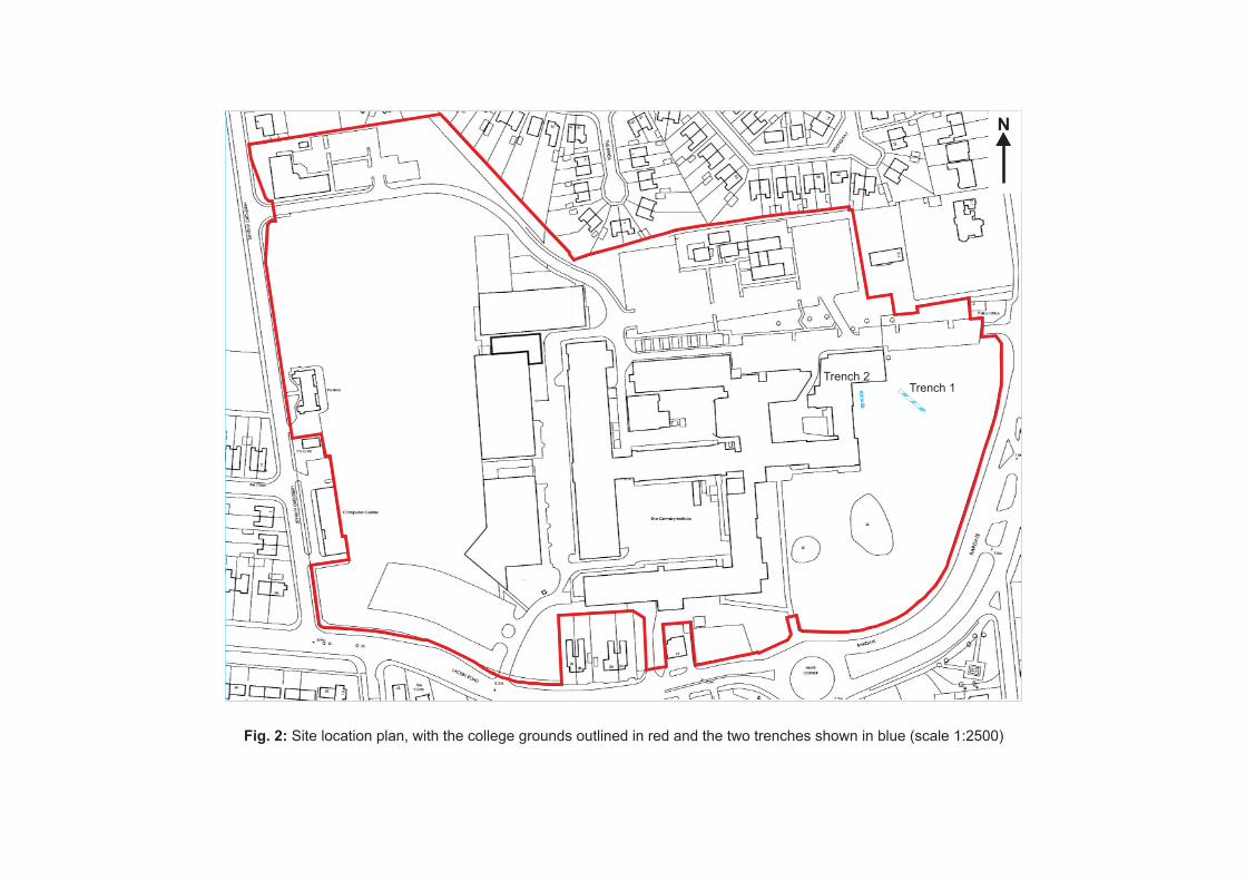
Fig. 2: Site location plan, with the college grounds outlined in red and the two trenches shown in blue (scale 1:2500)
Trench 1Trench 2
N


(107)
[106]
(105)
(111)
(109)
[106]
(105)
[112]
[110]
(105) (105)
(116)
(117)
[115]
[110]
[118]
(113)
(111)
[112]
[110]
N
+ +
(107) (109)
[106][108]
(113) (119)
(120)(105)
[112] [118]
(100)
(101)
(102)
(103)
(104)(105)
(105)
A+ +B
6.34m OD
5.44m OD
D+ +C
C+ +D
0 5m
Scale 1:50
Figure 4: Trench 1 planand main section atscale 1:50, with C-Dsection at scale 1:20
0 2m
Scale 1:20
[110]
(119)
A B
North-East facing section
(117)[115]

(209)
[208]
(211)
[210]
(205) [204]
[206]
(203)
(209)
[208]
(211)
[210]Step
N
A+ +B
Step
D+ +C
F+ +E
5.86m OD 5.86m OD
(205)(207)
[204]
[206]
(200)
(201)
(202)
(203)
A+ +B6.86m OD
C+ +D E+ +F
0 5m
Scale 1:50
0 2m
Scale 1:20
Figure 5: Trench 2 plan and main section at scale 1:50 and sections C-D and E-F at scale 1:20