the karst site of las palomas (guadalteba county, malaga, spain
TRANSCRIPT
lable at ScienceDirect
Quaternary International 243 (2011) 127e136
Contents lists avai
Quaternary International
journal homepage: www.elsevier .com/locate/quaint
The karst site of Las Palomas (Guadalteba County, Málaga, Spain): A preliminarystudy of its MiddleeLate Pleistocene archaeopaleontological record
F.J. Medianero a, J. Ramos b, P. Palmqvist c,*, G. Weniger d, J.A. Riquelme e, M. Espejo a, P. Cantalejo a,A. Aranda a, J.A. Pérez-Claros c, B. Figueirido c, P. Espigares f, S. Ros-Montoya f, V. Torregrosa g,J. Linstädter d, L. Cabello a, S. Becerra a, P. Ledesma a, I. Mevdev d, A. Castro h, M. Romero h,B. Martínez-Navarro i
a Escuela Taller Parque Guadalteba y Red Patrimonio Guadalteba, Área de Arqueología, Consorcio Guadalteba, Ctra. Campillos-Málaga, km 11, Campillos, 29320 Málaga, SpainbÁrea de Prehistoria, Departamento de Historia, Geografía y Filosofía, Facultad de Filosofía y Letras, Universidad de Cádiz, Avda, Gómez Ulla, s/n, 11003 Cádiz, SpaincDepartamento de Ecología y Geología, Área de Paleontología, Facultad de Ciencias, Universidad de Málaga, Campus Universitario de Teatinos, 29071 Málaga, Spaind Stiftung Neanderthal Museum, Talstrasse 300, D-40822 Mettmann, GermanyeDepartamento de Prehistoria y Arqueología, Universidad de Granada, Campus Universitario de Cartuja, 18071 Granada, SpainfMuseo de Prehistoria y Paleontología de Orce, Palacio de Segura, 18858 Orce, Granada, Spaing Fundación Geociencias & Art Natura Málaga, Avenida Sor Teresa Prat, 15, 29003 Málaga, Spainh Servicio de Protección Ambiental, Delegación de Medio Ambiente de Málaga, Junta de Andalucía, Mauricio Moro, Edificio Eurocom, 29071 Málaga, Spaini ICREA, Institut Català de Paleoecologia Humana i Evolució social-IPHES, Universitat Rovira i Virgili, Avda, de Catalunya, 43002 Tarragona, Spain
a r t i c l e i n f o
Article history:Available online 7 January 2011
* Corresponding author.E-mail address: [email protected] (P. Palmqvist).
1040-6182/$ e see front matter � 2011 Elsevier Ltd adoi:10.1016/j.quaint.2010.12.029
a b s t r a c t
Cleaning works in the cave of Las Palomas in Teba (Málaga, Spain), developed by the GuadaltebaConsortium, have provided a number of lithic tools and knapping products that may be ascribed to theMode III technotypological tradition as well as remains of a number of large mammal species typical ofMiddleeLate Pleistocene times. Topographic measurements help to place this ancient cave within a karstlandform. This discovery opens up new perspectives in the research on the Neanderthal groups thatinhabited the valleys of Guadalteba and Turón rivers in the middle basin of the Guadalhorce River, andthus in the southern region of the Iberian Peninsula.
� 2011 Elsevier Ltd and INQUA. All rights reserved.
1. Introduction
Results obtained in the field work developed within the karstsite of “Las Palomas” cave in Teba (Málaga, southern Spain) arediscussed in this article. These works were promoted by theGuadalteba Consortium for assessing the archaeological heritageof Guadalteba County. The geographical location of the cavityis 332863/4094817 (UTM coordinates, European-1950 datum)and the height above the sea level is approximately 450 m (Figs. 1and 2).
Field work, directed by F.J. Medianero, consisted of the cleaningand collection of archaeological and faunal records found on thesurface after the intense pillaging of this cavity, as well as theclearing of the abundant sedimentary breccias of the karst complex.Cleaning works for conditioning the cavity started in the year 2002and were intended to remove the abundant trash and the closing of
nd INQUA. All rights reserved.
the entrances, except the exit to the canyon mentioned above. Away for pedestrian access was enabled and also a platform orscaffold of low environmental impact that allows the passage ofmaterials and people. This platform will be used as a permanentinstallation in future works.
Cave topography, developed for locating the remains, providesan emerging view of the cavity, in which dissolution was the mainagent responsible for generating a karst system of greater propor-tions than those known in the late twentieth century (Ferrer andMarques, 1978; Baldomero, 1978; Aguado and Baldomero, 1979;Fernández, 1986; Fontao, 1986; Ferrer and Fernández, 1988;Recio-Ruiz, 1993). Apart from the main cave, the complexincludes a number of lateral galleries of unknown dimensions filledwith sediment, a doline and a “Sima” or chasm, which allow studyof the origin and development of this geological complex as well asthe relationship of the human settlements with the local environ-ment (Figs. 3 and 4).
Cleaning was made in two different areas: first, materialswere collected outside the complex at UTM coordinates 332848/
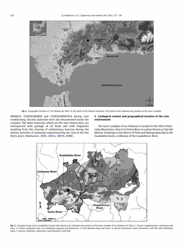
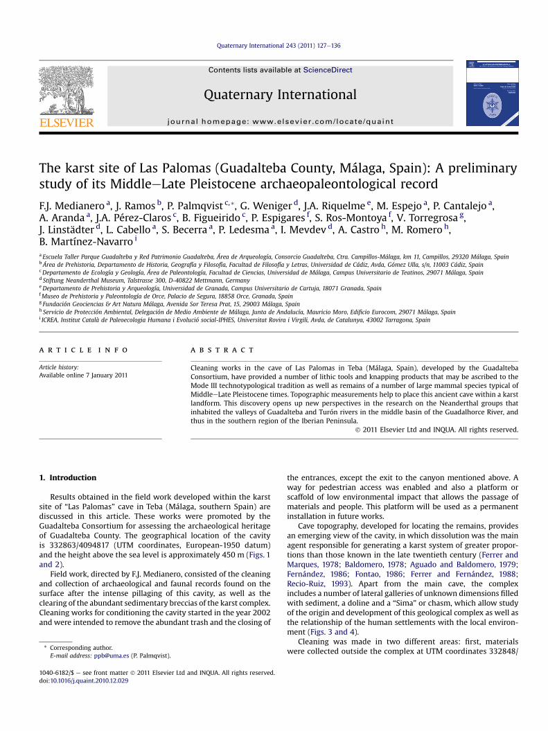
Fig. 1. Geographic location of “las Palomas de Teba” in the South of the Iberian Peninsula. The dotted circle indicates the position of the karst complex.
F.J. Medianero et al. / Quaternary International 243 (2011) 127e136128
4094834, 332820/409469 and 332829/40947814 during caveconditioning. Second, materials were also documented inside thecomplex. The latter materials, which are the ones shown here, areinterspersed with garbage of all kinds and with fragmentsresulting from the clearing of sedimentary breccias during theintense activities of spoliation experienced by the cave in the lastthirty years (Medianero, 2003, 2007a, 2007b, 2008).
Fig. 2. Geological map of the Guadalteba County (the dotted circle indicates the position ofclays. 2: Triassic variegated clays, red sandstones, gypsum and limestones. 3: Early Miocenmarls. 5: Jurassic dolomites, limestones and limestones with flint.
2. Geological context and geographical location of the caveenvironment
The karst complex of Las Palomas is located in the West Peñar-rubiaMountains, close to La Venta River, in a place known as Tajo delMolino. It belongs to the district of Teba and hydrographically to theGuadalteba basin, a tributary of the Guadalhorce River.
the karst complex of Las Palomas de Teba). 1: Triassic conglomerates, sandstones ande clays and marls. 4: Jurassic limestones, marls, limestones with flint and radiolarian
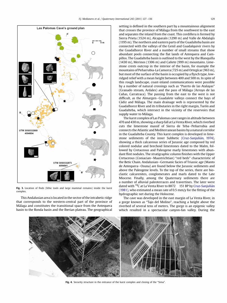
Fig. 3. Location of finds (lithic tools and large mammal remains) inside the karstcomplex.
F.J. Medianero et al. / Quaternary International 243 (2011) 127e136 129
ThisAndalusianarea is located in the sectorof the intrabetic ridgethat corresponds to the western-central part of the province ofMálaga and constitutes the transitional space from the Antequerabasin to the Ronda basin and the Iberian plateau. The geographical
Fig. 4. Security structure in the entrance of the
setting is defined in the southern part by a mountainous alignmentthat crosses the province of Málaga from the southwest to the eastand separates the inland from the coast. This cordillera is formed bySierra Prieta (1524 m), Alcaparaín (1290 m) and Valle de Abdalajís(1195m). Thenorthern and easternparts of theGuadalteba basin areconnected with the valleys of the Genil and Guadalquivir rivers bythe Guadalhorce River and a number of small streams that showabundant pools connecting the flat lands of Antequera and Cam-pillos. The Guadalteba basin is outlined to thewest by the Blanquilla(1430 m), Merinos (1306 m) and Cañete (999 m) mountains. Lime-stone crests outcrop in the interior of the basin, for example themountainsof Peñarrubia-LaCamorra (725m)andOrtegícar (963m),butmost of the surface of the basin is occupied by a flysch type, low-ridged relief with amean height between 400 and 500m. In spite ofthis rough landscape, coast-inland communications were possibleby a number of natural crossings such as “Puerto de las Atalayas”(Granado stream, Ardales) and the pass of Málaga (Arroyo de lasCañas, Carratraca). The passing from the east to the west is notdifficult, as the AlmargeneGuadalete valleys connect the bays ofCádiz and Málaga. The main drainage web is represented by theGuadalhorce River and its tributaries in the right margin, Turón andGuadalteba, which intersect in the vicinity of the reservoirs thatsupply water to Málaga.
Thekarst complexof Las Palomas cave ranges in altitudebetween470and430m, showinga sharp fall at LaVentaRiver,which riverbedcuts the limestone massif of Sierra de TebaePeñarrubia andconnects theAtlantic andMediterraneanbasins byanatural corridorin the Guadalteba County. This karst complex is developed in lime-stone sediments of the inner Subbetic (Cruz-Sanjulián, 1974),showing a thick calcareous series of Jurassic age composed by redcolored nodular and brechoid limestones dated to the Malm, fol-lowed by Cretaceous and Paleogene marly limestones with abun-dant flint nodules. The stratigraphic column finisheswith the UpperCretaceous (ConiacianeMaastrichtian) “red beds” characteristic ofthe Betic Chain. AndalusianeGermanic facies of Triassic age (Mantode AntequeraeOsuna) are found below the Jurassic sediments andabove the Paleogene levels. To the top of the series, there are bio-clastic calcarenites, conglomerates and marls dated to the LateMiocene. Finally, among the Quaternary sediments there area number of alluvial paleoterraces and travertines. The later weredatedwith 14C at La Venta River to 8872� 151 BP by Cruz-Sanjulián(1981), who estimated amean rate of 0.5 mm/y for the fitting of thehydrographic net during the Holocene.
The cave was developed in the east margin of La Venta River, ina gorge known as “Tajo del Molino”, reaching a height above theriverbed of several tens of meters. The gorge is an epigenic valleywhich resulted in a spectacular canyon-fan valley. During the
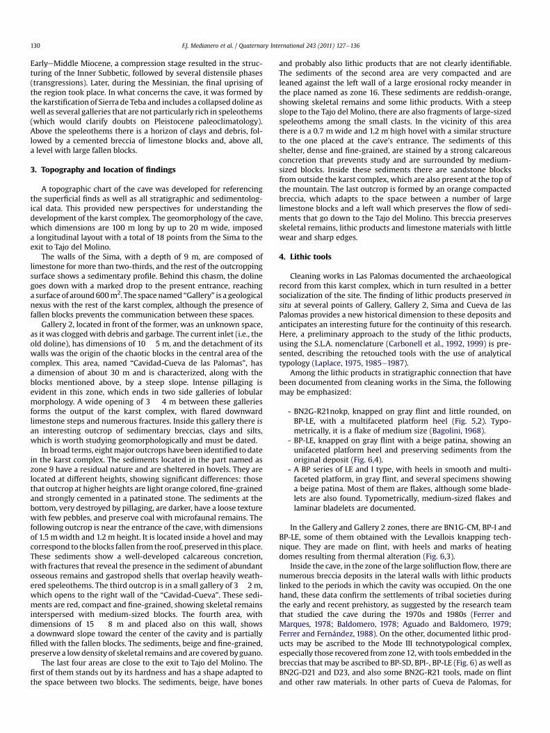
karst complex and closing of the “Sima”.
F.J. Medianero et al. / Quaternary International 243 (2011) 127e136130
EarlyeMiddle Miocene, a compression stage resulted in the struc-turing of the Inner Subbetic, followed by several distensile phases(transgressions). Later, during the Messinian, the final uprising ofthe region took place. In what concerns the cave, it was formed bythe karstification of Sierra de Teba and includes a collapsed doline aswell as several galleries that are not particularly rich in speleothems(which would clarify doubts on Pleistocene paleoclimatology).Above the speleothems there is a horizon of clays and debris, fol-lowed by a cemented breccia of limestone blocks and, above all,a level with large fallen blocks.
3. Topography and location of findings
A topographic chart of the cave was developed for referencingthe superficial finds as well as all stratigraphic and sedimentolog-ical data. This provided new perspectives for understanding thedevelopment of the karst complex. The geomorphology of the cave,which dimensions are 100 m long by up to 20 m wide, imposeda longitudinal layout with a total of 18 points from the Sima to theexit to Tajo del Molino.
The walls of the Sima, with a depth of 9 m, are composed oflimestone for more than two-thirds, and the rest of the outcroppingsurface shows a sedimentary profile. Behind this chasm, the dolinegoes down with a marked drop to the present entrance, reachinga surface of around600m2. The space named “Gallery” is a geologicalnexus with the rest of the karst complex, although the presence offallen blocks prevents the communication between these spaces.
Gallery 2, located in front of the former, was an unknown space,as it was clogged with debris and garbage. The current inlet (i.e., theold doline), has dimensions of 10 � 5 m, and the detachment of itswalls was the origin of the chaotic blocks in the central area of thecomplex. This area, named “Cavidad-Cueva de las Palomas”, hasa dimension of about 30 m and is characterized, along with theblocks mentioned above, by a steep slope. Intense pillaging isevident in this zone, which ends in two side galleries of lobularmorphology. A wide opening of 3 � 4 m between these galleriesforms the output of the karst complex, with flared downwardlimestone steps and numerous fractures. Inside this gallery there isan interesting outcrop of sedimentary breccias, clays and silts,which is worth studying geomorphologically and must be dated.
In broad terms, eightmajor outcrops have been identified to datein the karst complex. The sediments located in the part named aszone 9 have a residual nature and are sheltered in hovels. They arelocated at different heights, showing significant differences: thosethat outcrop at higher heights are light orange colored, fine-grainedand strongly cemented in a patinated stone. The sediments at thebottom, very destroyed by pillaging, are darker, have a loose texturewith few pebbles, and preserve coal with microfaunal remains. Thefollowing outcrop is near the entrance of the cave, with dimensionsof 1.5 mwidth and 1.2 m height. It is located inside a hovel and maycorrespond to the blocks fallen fromthe roof, preserved in this place.These sediments show a well-developed calcareous concretion,with fractures that reveal the presence in the sediment of abundantosseous remains and gastropod shells that overlap heavily weath-ered speleothems. The third outcrop is in a small gallery of 3� 2 m,which opens to the right wall of the “Cavidad-Cueva”. These sedi-ments are red, compact and fine-grained, showing skeletal remainsinterspersed with medium-sized blocks. The fourth area, withdimensions of 15 � 8 m and placed also on this wall, showsa downward slope toward the center of the cavity and is partiallyfilled with the fallen blocks. The sediments, beige and fine-grained,preserve a lowdensity of skeletal remains and are covered byguano.
The last four areas are close to the exit to Tajo del Molino. Thefirst of them stands out by its hardness and has a shape adapted tothe space between two blocks. The sediments, beige, have bones
and probably also lithic products that are not clearly identifiable.The sediments of the second area are very compacted and areleaned against the left wall of a large erosional rocky meander inthe place named as zone 16. These sediments are reddish-orange,showing skeletal remains and some lithic products. With a steepslope to the Tajo del Molino, there are also fragments of large-sizedspeleothems among the small clasts. In the vicinity of this areathere is a 0.7 m wide and 1.2 m high hovel with a similar structureto the one placed at the cave’s entrance. The sediments of thisshelter, dense and fine-grained, are stained by a strong calcareousconcretion that prevents study and are surrounded by medium-sized blocks. Inside these sediments there are sandstone blocksfrom outside the karst complex, which are also present at the top ofthe mountain. The last outcrop is formed by an orange compactedbreccia, which adapts to the space between a number of largelimestone blocks and a left wall which preserves the flow of sedi-ments that go down to the Tajo del Molino. This breccia preservesskeletal remains, lithic products and limestone materials with littlewear and sharp edges.
4. Lithic tools
Cleaning works in Las Palomas documented the archaeologicalrecord from this karst complex, which in turn resulted in a bettersocialization of the site. The finding of lithic products preserved insitu at several points of Gallery, Gallery 2, Sima and Cueva de lasPalomas provides a new historical dimension to these deposits andanticipates an interesting future for the continuity of this research.Here, a preliminary approach to the study of the lithic products,using the S.L.A. nomenclature (Carbonell et al., 1992, 1999) is pre-sented, describing the retouched tools with the use of analyticaltypology (Laplace, 1975, 1985e1987).
Among the lithic products in stratigraphic connection that havebeen documented from cleaning works in the Sima, the followingmay be emphasized:
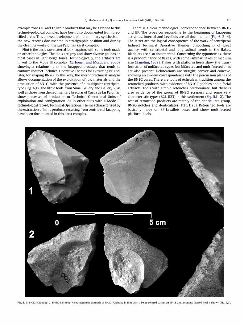
- BN2G-R21nokp, knapped on gray flint and little rounded, onBP-LE, with a multifaceted platform heel (Fig. 5,2). Typo-metrically, it is a flake of medium size (Bagolini, 1968).
- BP-LE, knapped on gray flint with a beige patina, showing anunifaceted platform heel and preserving sediments from theoriginal deposit (Fig. 6,4).
- A BP series of LE and I type, with heels in smooth and multi-faceted platform, in gray flint, and several specimens showinga beige patina. Most of them are flakes, although some blade-lets are also found. Typometrically, medium-sized flakes andlaminar bladelets are documented.
In the Gallery and Gallery 2 zones, there are BN1G-CM, BP-I andBP-LE, some of them obtained with the Levallois knapping tech-nique. They are made on flint, with heels and marks of heatingdomes resulting from thermal alteration (Fig. 6,3).
Inside the cave, in the zone of the large solifluction flow, there arenumerous breccia deposits in the lateral walls with lithic productslinked to the periods in which the cavity was occupied. On the onehand, these data confirm the settlements of tribal societies duringthe early and recent prehistory, as suggested by the research teamthat studied the cave during the 1970s and 1980s (Ferrer andMarques, 1978; Baldomero, 1978; Aguado and Baldomero, 1979;Ferrer and Fernández, 1988). On the other, documented lithic prod-ucts may be ascribed to the Mode III technotypological complex,especially those recovered from zone 12,with tools embedded in thebreccias that may be ascribed to BP-SD, BPI-, BP-LE (Fig. 6) as well asBN2G-D21 and D23, and also some BN2G-R21 tools, made on flintand other raw materials. In other parts of Cueva de Palomas, for
F.J. Medianero et al. / Quaternary International 243 (2011) 127e136 131
example zones 16 and 17, lithic products that may be ascribed to thistechnotypological complex have been also documented from brec-cified areas. This allows development of a preliminary synthesis onthe new records documented in stratigraphic position and duringthe cleaning works of the Las Palomas karst complex.
Flint is the basic rawmaterial for knapping,with some toolsmadeon other lithologies. The tools are gray and show diverse patinas, inmost cases in light beige tones. Technologically, the artifacts arelinked to the Mode III complex (Carbonell and Mosquera, 2000),showing a relationship in the knapped products that tends toconform Indirect Technical Operative Themes for extracting BP and,later, for shaping BN2G. In this way, the morphotechnical analysisallows documentation of the exploitation of raw materials and theproduction of BN1G, with the presence of a multipolar centripetaltype (Fig. 6,1). The lithic tools from Sima, Gallery and Gallery 2, aswell as those from the sedimentary breccias of Cueva de las Palomas,show processes of production or Technical Operational Units ofexploitation and configuration. As in other sites with a Mode IIItechnological record, TechnicalOperational Themes characterized bythe extraction of lithic products resulting from centripetal knappinghave been documented in this karst complex.
Fig. 5. 1: BN2G-R23nokp; 2: BN2G-R21nokp. A characteristic example of BN2G-R23nokp in
There is a clear technological correspondence between BN1Gand BP. The types corresponding to the beginning of knappingactivities, internal and Levallois are all documented (Fig. 6, 2e4).The latter are the logical consequence of the work of centripetalIndirect Technical Operative Themes. Smoothing is of greatquality, with centripetal and longitudinal trends in the flakes.Bladelets are also documented. Concerning the typometries, thereis a predominance of flakes, with some laminar flakes of mediumsize (Bagolini, 1968). Flakes with platform heels show the trans-formation of unifaceted types, but bifaceted and multifaceted onesare also present. Delineations are straight, convex and concave,showing an evident correspondence with the percussion planes ofthe BN1G cores. There are tools of Acheulean tradition among theretouched products, with evidence of BN1GC pebbles and bifacialartifacts. Tools with simple retouches predominate, but there isalso evidence of the group of BN2G scrapers and some verycharacteristic types (R21, R23) in this settlement (Fig. 5,1e2). Therest of retouched products are mainly of the denticulate group,BN2G notches and denticulates (D21, D23). Retouched tools arebasically made on BP-Levallois bases and show multifacetedplatform heels.
flint with a beige colored patina on BP-LE and a convex faceted heel is shown (Fig. 5,2).
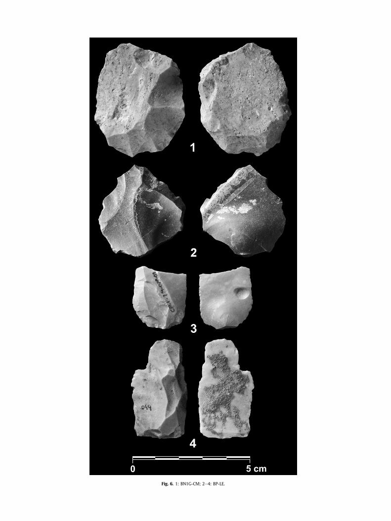
Fig. 6. 1: BN1G-CM; 2e4: BP-LE.
F.J. Medianero et al. / Quaternary International 243 (2011) 127e136 133
5. Large mammal remains
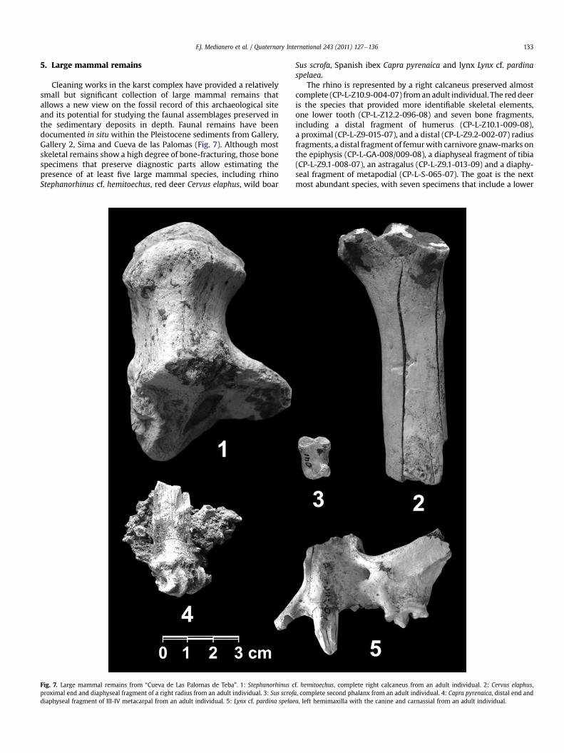
Cleaning works in the karst complex have provided a relativelysmall but significant collection of large mammal remains thatallows a new view on the fossil record of this archaeological siteand its potential for studying the faunal assemblages preserved inthe sedimentary deposits in depth. Faunal remains have beendocumented in situ within the Pleistocene sediments from Gallery,Gallery 2, Sima and Cueva de las Palomas (Fig. 7). Although mostskeletal remains show a high degree of bone-fracturing, those bonespecimens that preserve diagnostic parts allow estimating thepresence of at least five large mammal species, including rhinoStephanorhinus cf. hemitoechus, red deer Cervus elaphus, wild boar
Fig. 7. Large mammal remains from “Cueva de Las Palomas de Teba”. 1: Stephanorhinus cproximal end and diaphyseal fragment of a right radius from an adult individual. 3: Sus scrofdiaphyseal fragment of III-IV metacarpal from an adult individual. 5: Lynx cf. pardina spelae
Sus scrofa, Spanish ibex Capra pyrenaica and lynx Lynx cf. pardinaspelaea.
The rhino is represented by a right calcaneus preserved almostcomplete (CP-L-Z10.9-004-07) fromanadult individual. The reddeeris the species that provided more identifiable skeletal elements,one lower tooth (CP-L-Z12.2-096-08) and seven bone fragments,including a distal fragment of humerus (CP-L-Z10.1-009-08),a proximal (CP-L-Z9-015-07), and a distal (CP-L-Z9.2-002-07) radiusfragments, a distal fragment of femurwith carnivore gnaw-marks onthe epiphysis (CP-L-GA-008/009-08), a diaphyseal fragment of tibia(CP-L-Z9.1-008-07), an astragalus (CP-L-Z9.1-013-09) and a diaphy-seal fragment of metapodial (CP-L-S-065-07). The goat is the nextmost abundant species, with seven specimens that include a lower
f. hemitoechus, complete right calcaneus from an adult individual. 2: Cervus elaphus,a, complete second phalanx from an adult individual. 4: Capra pyrenaica, distal end anda, left hemimaxilla with the canine and carnassial from an adult individual.
F.J. Medianero et al. / Quaternary International 243 (2011) 127e136134
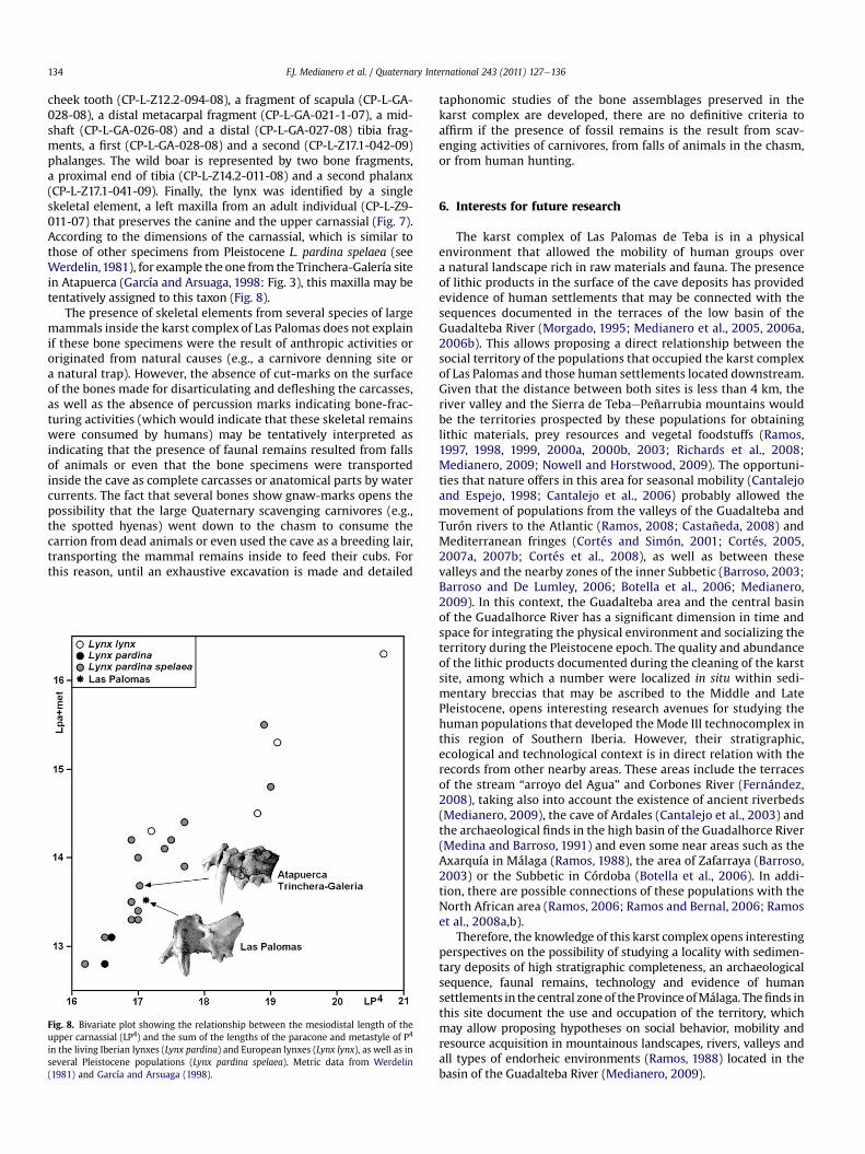
cheek tooth (CP-L-Z12.2-094-08), a fragment of scapula (CP-L-GA-028-08), a distal metacarpal fragment (CP-L-GA-021-1-07), a mid-shaft (CP-L-GA-026-08) and a distal (CP-L-GA-027-08) tibia frag-ments, a first (CP-L-GA-028-08) and a second (CP-L-Z17.1-042-09)phalanges. The wild boar is represented by two bone fragments,a proximal end of tibia (CP-L-Z14.2-011-08) and a second phalanx(CP-L-Z17.1-041-09). Finally, the lynx was identified by a singleskeletal element, a left maxilla from an adult individual (CP-L-Z9-011-07) that preserves the canine and the upper carnassial (Fig. 7).According to the dimensions of the carnassial, which is similar tothose of other specimens from Pleistocene L. pardina spelaea (seeWerdelin,1981), for example the one from the Trinchera-Galería sitein Atapuerca (García and Arsuaga, 1998: Fig. 3), this maxilla may betentatively assigned to this taxon (Fig. 8).
The presence of skeletal elements from several species of largemammals inside the karst complex of Las Palomas does not explainif these bone specimens were the result of anthropic activities ororiginated from natural causes (e.g., a carnivore denning site ora natural trap). However, the absence of cut-marks on the surfaceof the bones made for disarticulating and defleshing the carcasses,as well as the absence of percussion marks indicating bone-frac-turing activities (which would indicate that these skeletal remainswere consumed by humans) may be tentatively interpreted asindicating that the presence of faunal remains resulted from fallsof animals or even that the bone specimens were transportedinside the cave as complete carcasses or anatomical parts by watercurrents. The fact that several bones show gnaw-marks opens thepossibility that the large Quaternary scavenging carnivores (e.g.,the spotted hyenas) went down to the chasm to consume thecarrion from dead animals or even used the cave as a breeding lair,transporting the mammal remains inside to feed their cubs. Forthis reason, until an exhaustive excavation is made and detailed
Fig. 8. Bivariate plot showing the relationship between the mesiodistal length of theupper carnassial (LP4) and the sum of the lengths of the paracone and metastyle of P4
in the living Iberian lynxes (Lynx pardina) and European lynxes (Lynx lynx), as well as inseveral Pleistocene populations (Lynx pardina spelaea). Metric data from Werdelin(1981) and García and Arsuaga (1998).
taphonomic studies of the bone assemblages preserved in thekarst complex are developed, there are no definitive criteria toaffirm if the presence of fossil remains is the result from scav-enging activities of carnivores, from falls of animals in the chasm,or from human hunting.
6. Interests for future research
The karst complex of Las Palomas de Teba is in a physicalenvironment that allowed the mobility of human groups overa natural landscape rich in raw materials and fauna. The presenceof lithic products in the surface of the cave deposits has providedevidence of human settlements that may be connected with thesequences documented in the terraces of the low basin of theGuadalteba River (Morgado, 1995; Medianero et al., 2005, 2006a,2006b). This allows proposing a direct relationship between thesocial territory of the populations that occupied the karst complexof Las Palomas and those human settlements located downstream.Given that the distance between both sites is less than 4 km, theriver valley and the Sierra de TebaePeñarrubia mountains wouldbe the territories prospected by these populations for obtaininglithic materials, prey resources and vegetal foodstuffs (Ramos,1997, 1998, 1999, 2000a, 2000b, 2003; Richards et al., 2008;Medianero, 2009; Nowell and Horstwood, 2009). The opportuni-ties that nature offers in this area for seasonal mobility (Cantalejoand Espejo, 1998; Cantalejo et al., 2006) probably allowed themovement of populations from the valleys of the Guadalteba andTurón rivers to the Atlantic (Ramos, 2008; Castañeda, 2008) andMediterranean fringes (Cortés and Simón, 2001; Cortés, 2005,2007a, 2007b; Cortés et al., 2008), as well as between thesevalleys and the nearby zones of the inner Subbetic (Barroso, 2003;Barroso and De Lumley, 2006; Botella et al., 2006; Medianero,2009). In this context, the Guadalteba area and the central basinof the Guadalhorce River has a significant dimension in time andspace for integrating the physical environment and socializing theterritory during the Pleistocene epoch. The quality and abundanceof the lithic products documented during the cleaning of the karstsite, among which a number were localized in situ within sedi-mentary breccias that may be ascribed to the Middle and LatePleistocene, opens interesting research avenues for studying thehuman populations that developed the Mode III technocomplex inthis region of Southern Iberia. However, their stratigraphic,ecological and technological context is in direct relation with therecords from other nearby areas. These areas include the terracesof the stream “arroyo del Agua” and Corbones River (Fernández,2008), taking also into account the existence of ancient riverbeds(Medianero, 2009), the cave of Ardales (Cantalejo et al., 2003) andthe archaeological finds in the high basin of the Guadalhorce River(Medina and Barroso, 1991) and even some near areas such as theAxarquía in Málaga (Ramos, 1988), the area of Zafarraya (Barroso,2003) or the Subbetic in Córdoba (Botella et al., 2006). In addi-tion, there are possible connections of these populations with theNorth African area (Ramos, 2006; Ramos and Bernal, 2006; Ramoset al., 2008a,b).
Therefore, the knowledge of this karst complex opens interestingperspectives on the possibility of studying a locality with sedimen-tary deposits of high stratigraphic completeness, an archaeologicalsequence, faunal remains, technology and evidence of humansettlements in the central zoneof the ProvinceofMálaga. Thefinds inthis site document the use and occupation of the territory, whichmay allow proposing hypotheses on social behavior, mobility andresource acquisition in mountainous landscapes, rivers, valleys andall types of endorheic environments (Ramos, 1988) located in thebasin of the Guadalteba River (Medianero, 2009).
F.J. Medianero et al. / Quaternary International 243 (2011) 127e136 135
Acknowledgments
We thank Consejería de Cultura (Junta de Andalucía) forapproving this project and Guadalteba Consortium and AndalusianEmployment Service (SAE) for financing it. The following studentsof the archeology workroom of “Escuela Taller Parque Guadalteba”helped during field and laboratory work: Carmen Palmero, JoséMora, Juana García, Gema Crespillo, Esther Baeza, Rocío García, AnaMaldonado, Emilia Martínez, Noelia Mesa, Yolanda Pinta, ManoliPonce, Fabiola Ríos, María Anaya, Ana Galván, Miguel García, SandraMateo, Virginia Montesino, Lidia Rosado, Cándida Sayago, AnaCapitán, Melody Romero, Sonia Martín, Marina Mesa, Rocío Pen-dón, Inmaculada Anaya, Gema Avilés, Isabel García, Laura Gallardo,Sara Guerrero, Carmen Jiménez, Celeste Jurado, Nieves Pinta, andoperators Borja Valencia, Rafael Camacho and Javier Perea. Thisresearch was conducted under Spanish Ministry of Sciencesprojects CGL08-04896 to PP and CGL2009-08827 and CGL2010-15326 to BMN.
References
Aguado, T., Baldomero, A., 1979. Estudio de los materiales de superficie de la Cuevade las Palomas (Teba, Málaga). Mainake 1, 29e59.
Bagolini, B., 1968. Ricerche sulle dimensioni dei manufatti litici prehistorici nonritoccati. Annalli dell’Universitá di Ferrara XV (10), 195e219.
Baldomero, A., 1978. Noticias del hallazgo de un vaso eneolítico. Baetica 1, 167e170.Barroso, C., 2003. El Pleistoceno Superior de la Cueva del Boquete de Zafarraya.
Arqueología, Monografias Junta de Andalucía, Sevilla.Barroso, C., De Lumley, H., 2006. La Grotte du Boquete de Zafarraya. Málaga,
Andalousie. Consejería de Cultura, Junta de Andalucía, Sevilla.Botella, D., Barroso, C., Riquelme, J.A., Abdessalok, S., Caparrós, M., Verdú, L.,
Monge, G., García, J.A., 2006. La Cueva del Ángel (Lucena, Córdoba), un yaci-miento del Pleistoceno Medio y Superior del Sur de la Península Ibérica. Tra-bajos de Prehistoria 63, 153e165.
Cantalejo, P., Espejo, M.M., 1998. Arte rupestre paleolítico del sur peninsular. Con-sideraciones sobre los ciclos artísticos de los grandes santuarios y sus territoriosde influencia. Revista Atlántica-Mediterránea de Prehistoria y ArqueologíaSocial 1, 77e96.
Cantalejo, P., Maura, R., Espejo, M., Ramos, J., Medianero, J., Aranda, A., Mora, J.,Becerra, M., Castañeda, V., 2003. Sobre los temas, las técnicas de ejecución yrepresentación del arte paleolítico conservado en la Cueva de Ardales (Málaga).Pliocénica 3, 54e61.
Cantalejo, P., Maura, R., Espejo, M., Ramos, J., Medianero, J., Aranda, A., Durán, J.J.,2006. La Cueva de Ardales: arte prehistórico y ocupación en el PaleolíticoSuperior. CEDMA, Diputación Provincial de Málaga.
Castañeda, V., 2008. El primer poblamiento humano de la serranía de Ronda y surelación con el campo de Gibraltar. Mainake XXX, 331e344.
Carbonell, E., Mosquera, M., Ollé, A., Rodríguez, X.P., Sala, R., Vaquero, M.,Vergés, J.M., 1992. New elements of the logical analytic system. In: First Inter-national Meeting on Technical Systems to Configure Lithic Objects of ScarceElaboration. Cahier Noir, vol. 6, pp. 5e61.
Carbonell, E., Márquez, B., Mosquera, M., Olí, A., Rodríguez, X.P., Sala, R., Vergès, J.M.,1999. El Modo 2 en Galería. Análisis de la industria lítica y sus procesos técnicos.In: Juan Fernández-Lomana, C.D., Rosas-González, A., Carbonell, E. (Eds.), Ata-puerca: ocupaciones humanas y paleoecología del yacimiento de Galería.Arqueología en Castilla y León, Memorias, vol. 7, pp. 299e352.
Carbonell, E., Mosquera, M. (Eds.), 2000. Las claves del pasado: la llave del futuro.Arola, Tarragona.
Cortés, M., 2005. El extremo occidente neandertal. El Paleolítico Medio en el Sur dela Península Ibérica. Neandertales cantábricos, estado de la cuestión. Mono-grafías Museo de Altamira 20, 55e74.
Cortés, M., 2007a. La evolución en mosaico. El tránsito del Paleolítico Medio-Superior en el Sur de la Península Ibérica. Perspectiva desde una tesela. In:Cabrera-Valdés, V., Bernaldo, F., Maillo, J.M. (Eds.), En el Centenario de la Cuevade El Castillo: el ocaso de los Neandertales, pp. 145e164.
Cortés, M., 2007b. Cueva Bajondillo (Torremolinos). Secuencia cronocultural ypaleoambiental del Cuaternario reciente en la Bahía de Málaga. CEDMA,Diputación Provincial de Málaga.
Cortés, M., Simón, M.D., 2001. Cave Bajondillo (Torremolinos, Málaga, Andalucia):news of the transition between the Middle and Upper Paleolithic in the South ofIberian Peninsula. Les premiers hommes modernes de la Peninsule iberique.Actes du Colloque de la Commision VIII de l`UISPP. 103e115.
Cortés, M., Morales, A., Simón, M.D., Bergadà, M.M., Delgado-Huertas, A., López-García, P., López-Sáez, J.A., Lozano-Francisco, M.C., Riquelme, J.A., Roselló, E.,Sánchez-Marco, A., Vera-Peláez, J.L., 2008. Palaeoenvironmental and culturaldynamics of the coast of Málaga (Andalusia, Spain) during the upperPleistocene and eEarly Holocene. Quaternary Science Reviews 23e24,2176e2193.
Cruz-Sanjulián, J., 1974. Estudio geológico del sector Teba-Cañete La Real-Osuna(Cordilleras Béticas, región Occidental). Ph.D. Thesis Dissertation, University ofGranada.
Cruz-Sanjulián, J., 1981. Evolución geomorfológica e hidrogeológica reciente en elsector Teba-Cañete La Real (Málaga) a la luz de la datación de formacionestravertínicas. Boletín Geológico y Minero 92, 297e308.
Fernández, L.E., 1986. Tipología de la cerámica lisa de la Cueva de las Palomas (Teba,Málaga). Unpubl. Ms. Thesis. University of Málaga, Spain.
Fernández, J.J., 2008. Las industrias líticas paleolíticas del Bajo Guadalquivir: RíoCorbones (y II). Carel 6, 2395e2497.
Ferrer, J.E., Marques, I., 1978. Avance de las campañas arqueológicas realizadas en laCueva de las Palomas, Teba (Málaga). Baetica 1, 195e199.
Ferrer, J.E., Fernández, J., 1988. Avance al estudio de la industria en sílex de la Cuevade las Palomas (Teba, Málaga). Mainake 8-9, 5e14.
Fontao, M.M., 1986. La cerámica decorada de la Cueva de las Palomas (Teba,Málaga), técnicas y estilos. Unpubl. Ms. Thesis. University of Málaga, Spain.
García, N., Arsuaga, J.L., 1998. The carnivore remains from the hominid-bearingTrinchera-Galería, Sierra de Atapuerca, Middle Pleistocene site (Spain). Geobios31, 659e674.
Laplace, G., 1975. La typologie analytique et structurale: base rationnelle d’étudedes industries lithiques et osseuses. Colloques Nationaux CNRS 932. 91e141.
Laplace, G., 1985e1987. Un exemple de nouvelle écriture de la grille typologique.Dialekitkê, Cahiers de Typologie Analytique. 16e21.
Medianero, F.J., 2003. Informe de expolio en el yacimiento arqueológico de la cuevade Las Palomas (Teba, Málaga). Unpublished Report, Delegación de Cultura deMálaga.
Medianero, F.J., 2007a. Estado actual en el acondicionamiento, cerramiento y lim-pieza en la Cueva de las Palomas de Teba (Teba, Málaga). Unpublished Report,Archivo de la Delegación de Cultura de Málaga.
Medianero, F.J., 2007b. Informe de intromisión, daño y robo en la verja de entradaa la Cueva de las Palomas de Teba. Málaga. Unpublished Report, Archivo de laDelegación Provincial de Cultura de Málaga.
Medianero, F.J., 2008. Informe de intromisión y expolio. Cueva de las Palomas deTeba. Unpublished Report, Archivo de la Delegación de Cultura de Málaga.
Medianero, F.J., 2009. Turismo y Patrimonio Arqueológico: la Comarca de Gua-dalteba. Ph.D. Thesis Dissertation, University of Málaga.
Medianero, F.J., Ramos, J., Cantalejo, P., Espejo, M.M., Maura, R., 2005. Evidencias deactividad prehistórica y nuevas estructuras romanas en las Eras de Peñarrubia,Parque Guadalteba (Campillos, Málaga). Mainake 27, 303e321.
Medianero, F.J., Ramos, J., Cantalejo, P., Espejo, M.M., Maura, R., Durán, J.J., 2006a.Grupos de cazadores-recolectores en la cuenca baja del río Guadalteba. Zonifica-ción del área y aproximación a sus producciones y contexto social. In: PatrimonioGuadalteba, vol. 1. Parque Arqueológico Guadalteba, Campillos, Málaga. 9e25.
Medianero, F.J., Ramos, J., Cantalejo, P., Espejo, M.M., 2006b. Parque Guadalteba:desde la pertenencia al territorio hasta su domino y transformación del Paisaje.AKROS, la Revista del Museo 5, 93e102.
Medina, F., Barroso, R., 1991. Estudio tecnotipológico del yacimiento lítico desuperficie de Cuarterones (Villanueva del Rosario, Málaga). Proyecto: Losyacimientos líticos de superficie del Alto Valle del Guadalhorce (Málaga,España). Bases para el estudio integral del poblamiento prehistórico de la zona.Segunda Campaña. In: Anuario Arqueológico de Andalucía, vol. II 50e58.
Morgado, A., 1995. La Prehistoria: las primeras sociedades. In: García, E., Martínez, V.,Morgado, A. (Eds.), El Bajo Guadalteba (Málaga): espacio y poblamiento. Unaaproximación arqueológica a Tebay su entorno. CEDMA, Diputación Provincial deMálaga, pp. 27e87.
Nowell, G.M., Horstwood, M.S.A., 2009. Comments on Richards et al., Journal ofArchaeological Science 35, 2008, Strontium isotope evidence of Neanderthalmobility at the site of Lakonis, Greece using laser-ablation PIMMS. Journal ofArchaeological Science 39 (7), 1334e1341.
Ramos, J., 1988. El poblamiento prehistórico del Alto Vélez hasta la Edad del Bronce.Diputación Provincial de Málaga.
Ramos, J., 1997. Disputados entre la Antropología y la Historia. Un acercamiento so-cioeconómico para el estudio de los cazadores-recolectores. Revista Atlántica-Mediterránea de Prehistoria y Arqueología Social I, 7e32.
Ramos, J., 1998. La ocupación prehistórica de los medios kársticos de montaña enAndalucía. In: Durán, J.J., López-Martínez, J. (Eds.), Karst en Andalucía. InstitutoTecnológico Geominero de España, pp. 63e84.
Ramos, J., 1999. Europa prehistórica. Cazadores y recolectores. Editorial Sílex,Madrid.
Ramos, J., 2000a. Las formaciones sociales son mucho más que adaptación eco-lógica. Revista Atlántica-Mediterránea de Prehistoria y Arqueología Social III,29e46.
Ramos, J., 2000b. Las sociedades cazadoras-recolectoras: un balance historiográficode sus formas de estudio en Europa. Boletín de Antropología Americana 36,77e136.
Ramos, J., 2003. Metodología para el estudio de las comunidades cazadoras-recol-ectoras. Reflexiones en el ámbito del Estrecho de Gibraltar. In: Ramos, J.,Bernal, D., Castañeda, V. (Eds.), El Abrigo y la Cueva de Benzú en la Prehistoriade Ceuta. Consejería de Educación y Cultura de Ceuta, UNED and Universidad deCádiz, pp. 27e54.
Ramos, J., 2006. Las sociedades cazadoras-recolectoras en el norte de África y sur dela Península Ibérica. Reflexiones sobre relaciones y contactos, desde los orígenesdel poblamiento a los grupos portadores de tecnocomplejos de modo III. In:Bernal, D., Raissouni, B., Ramos, J., Bouzouggar, A. (Eds.), Actas del I SeminarioHispano-Marroquí de especialización en Arqueología, Cádiz, pp. 95e111.

F.J. Medianero et al. / Quaternary International 243 (2011) 127e136136
Ramos, J., Bernal, D. (Eds.), 2006. El Proyecto Benzú. 250.000 años de historia en laorilla africana del Círculo del Estrecho. 30 preguntas y 10 opiniones. CiudadAutónoma de Ceuta y Universidad de Cádiz, Cádiz.
Ramos, J., 2008. Memoria del proyecto de investigación: la ocupación pre-histórica de la campiña litoral y Banda Atlántica de Cádiz. Aproximación alestudio de las sociedades cazadoras-recolectoras, tribales-comunitarias yclasistas iniciales. Monografías de Arqueología. Junta de Andalucía, Con-sejería de Cultura.
Ramos, J., Pérez, M., Vijande, E., Cantillo, J.J., 2008a. Nuevas perspectivas en elestudio de las sociedades tribales comunitarias neolíticas en el área del Estre-cho de Gibraltar. In: Ramos, J., Zouak, M., Bernal, D., y Raissouni, B. (Eds.), Lasocupaciones humanas de la cueva de Caf Taht el Ghar (Tetuán). Los productosarqueológicos en el contexto del Estrecho de Gibraltar. Colección de Mono-grafías del Museo Arqueológico de Tetuán, vol. I. Universidad de Cádiz,
Diputación de Cádiz y Dirección Regional de Cultura Tánger-Tetuán del Reino deMarruecos, Cádiz, pp. 93e133.
Ramos, J., Bernal, D., Domínguez-Bella, S., Calado, D., Ruiz, B., Gil, M.J., Clemente, I.,Durán, J.J., Vijande, E., Chamorro, S., 2008b. The Benzú rockshelter: a middlePalaeolithic site on the North African coast. Quaternary Science Reviews 27,2210e2218.
Richards, M., Harvati, K., Grimes, V., Smith, C., Smith, T., Hublin, J.-J., Karkanas, P.,Panagopoulou, E., 2008. Strontium isotope evidence of Neanderthal mobility atthe site of Lakonis, Greece using laser-ablation PIMMS. Journal of Archaeolog-ical Science 35, 1251e1256.
Recio-Ruiz, A., 1993. Informe arqueológico del Término Municipal de Teba (Málaga).Anuario Arqueológico de Andalucía III, 413e418.
Werdelin, L., 1981. The evolution of lynxes. Annales Zoologici Fennici 18,37e71.