sitesolutions - amazon web services · waste contractor and the burning of builders' waste ......
TRANSCRIPT

SITESOLUTIONSInspect
This report is issued for the property described as:
Overview Example garage site.
ClientAsset Management Plc.
Report ReferenceAEL-1103-TSC-999999
Customer ReferenceSpecimen report
Report produced on2016
Current useVacant Car dealership/garage and scaffolding hire company
Proposed useVacant Car dealership/garage and scaffolding hire company
Report written byInsert Name
Contaminated Land Liabilities
None Identified
NO ISSUES
IDENTIFIED
Regulatory Response NO ISSUES
IDENTIFIED
Top Level Environmental Compliance
1.Builders' Waste
2.Fuel and Chemical Storage
3.Drainage
4.Asbestos Management
5.Energy Performance Certificate (EPC)
ISSUES
IDENTIFIED
Financial Risk
None Identified
NO ISSUES
IDENTIFIED
CONTACT DETAILS-----------------------------------------If you require assistance please contact us on:
0844 844 9966-----------------------------------------or by email at:[email protected]

Recommendations
Regulatory ResponseEnquiries have been directed to the Local Authority's Environmental Health Department regarding the status of the Site in relation to their Contaminated Land Inspection Strategy. A response is still outstanding and once received, will be included in the final version of the report. It should be noted this may affect the overall risk assessment and it is advised you review the final version of the report.
Top Level Environmental Compliance1.Builders waste: All piles of builders' waste should be removed by an licensed waste contractor and the burning of builders' waste should stop with immediate effect.
2.Fuel and Chemical Storage: All empty tanks and containers should be removed by a licensed waste contractor. As a matter of best practice all hazardous chemicals/fuels that are to remain on Site should be stored in adequate secondary containment.
3.Drainage: Businesses have a strict duty of care to make sure any waste water with oil and silt is disposed of lawfully. We recommend obtaining a drainage plan for the Site, confirming the drainage infrastructure and discharge points to the foul or storm sewer network. Particular attention should be drawn to confirm where effluent from the wash bay discharges. If unavailable a drainage survey should be commissioned and any recommendations actioned.
4.Asbestos: Review current documentation held by the landlord for an Asbestos register and management plan. If unavailable we recommend commissioning an asbestos survey.
5.Energy Performance Certificate (EPC): Review current documentation held by the landlord for an EPC. If unavailable we recommend commissioning an EPC certificate.
AEL-1103-TSC-704624 Site Solutions // Inspect 2
Understanding this report
The Site Solutions Inspect report is a preliminary risk assessment (Phase1).
The aim of the Site Solutions Inspect is to identify significant potential
contaminated land liabilities and financial risk which may be associated
with the Site. It also provides a top level review of compliance with key
environmental legislation.1
Scope of Works
The agreed scope of works and the data sources included in this assessment are detailed below:
A Site inspection and liaison with the current occupiers of the Site in May 2016;
A review of available current and historical Ordnance Survey maps and other sources of historical information relating to the Site and surrounding area;
A review of information contained within a Landmark environmental data pack and other relevant environmental information held by publicly available databases;
Targeted regulatory consultation with the Environmental Health and Planning Departments, the Environment Agency and the Petroleum Licensing Authority;
A study of the environmental sensitivity of the Site, with reference to the local geological, hydrological and hydrogeological setting;
The derivation of a Conceptual Site Model, identifying potential pollutant linkages and an assessment of the risk and liabilities associated with the Site; and
The provision of an interpretive report, including a qualitative risk assessment and recommendations for any further work which may be required.
Formation of conclusions and recommendations for further work (if required) to include estimated capital expenditure for each material issue identified.
Context of transaction
The Site is being acquired for the inclusion into a Pension Scheme. The Site is currently a car dealership, with an associated garage facility as well as a scaffolding hire yard.
1 Please refer to the Methodology section at the end of this report for more details
Site Solutions // Inspect

Summary of Findings
Contaminated Land Liabilities
Contaminated Land Liabilities
Risk Comment
None Identified Moderate The south of the Site has been in use as a car dealership with associated servicing and repair facilities since May 2014. Operations ceased in December 2015. Prior to this the entire Site was solely used for body repair of used cars c.1968-2014 with similar operations anticipated during this time.
Most operations are likely to have occurred indoors due to the nature of the work. Hardstanding will act as a barrier and protect the underlying bedrock hydrogeology as well as creating a barrier between site users and the shallow sub-surface soils. In addition, potential sources of contamination have subsequently been removed, or left empty. No obvious spills or signs of contamination were observed on the day of assessment.
An above ground tank leaked c.2013. The direction of the leak reportedly flowed along tarmac. Where it pooled, absorbent granules were laid and subsequently removed from the Site. This would have reduced the likelihood of any contaminants entering the shallow sub surface soils, and therefore into the underlying groundwater. Natural attenuation of any residual contamination since this time would reduce the environmental risk further.
The north of the Site is currently occupied by a builders' yard and has been for up to 10 years. A number of piles of builders' waste were noted in the yard currently occupied by the builders yard. The contents of the waste included brick, tarmac, wood, plasterboard, soil, metal, plastic and concrete. Evidence of ash from burning was also identified.
Contaminants potentially could migrate vertically and laterally from rainfall infiltration, mobilising into shallow sub surface soils and underlying Principal Aquifer. In addition, wind blown ash could settle in the adjacent Canal.
Regulatory Response
Contaminated Land Officer
Enquiries have been directed to the Local Authority's Environmental Health Department regarding the status of the Site in relation to their Contaminated Land Inspection Strategy. A response is still outstanding and once received, will be included in the final version of the report. It should be noted this may affect the overall risk assessment.
Planning Department
A review of the Local Authorities online planning portal reveals one planning application of interest. A summary of this application is as follows:
• Ref: 01/11/201500 for the proposed valet bay extension. This application was granted. No conditions relating to contaminated land was placed on this application.
AEL-1103-TSC-704624 Site Solutions // Inspect 4,
Risk Assessment
Petroleum Licencing
Enquires were directed to the Trading Standards Officer within Example County Council Trading Standards. A response was received on the 19th April and is summarised below:
• A review of the Local Authority’s records confirm no above or below ground fuel storage tanks have been identified at the Site.
Top Level Environmental Compliance
Compliance Issues
1.Builders' waste: Several piles of builders' waste were located across the yard area in the north, with evidence of ash from burning also identified. The contents of the waste included brick, tarmac, wood, plasterboard, soil, metal, plastic and concrete.
2.Fuel and Chemical Storage: There are a number of bulk storage tanks and small containers which were either containing hazardous chemicals/fuels or were empty. These were associated with the current and former operations of the Site and are detailed as follows:
• Approximately 2,500L tank; empty (formerly containing heating oil) • 950L tank; heating oil• Five 199L drums; engine oil/empty• 90L drainer; empty (formerly containing waste engine oil)• Numerous 1-25L containers; paints, oils, degreasers, thinners, solvents and cleaner• 1000L Intermediate Bulk Container; empty (formerly containing red diesel)
3.Drainage: A wash bay used to valet vehicles was located adjacent north east of the main building. The wash bay was approximately 10m2 with a single drain at the lowest point in the centre. No drainage plan was made available to view during the Site inspection.
4.Asbestos: Given the age of the building, asbestos could be present. No asbestos register was available to review during the site inspection
5.Energy Performance Certificate (EPC): No EPC was made available to view during the Site inspection.
Financial Risk
Financial Risk Risk Comment
Risk of diminution in value and/or future Site saleability being affected.
Low This assessment has not identified any significant material issues that could impact the Site value and/or saleability.
AEL-1103-SIT-736350 Site Solutions // Inspect 5
Risk Assessment
Contaminated Land Risk and Liabilities
Below is a Conceptual Site Model which explores the environmental risk at the Site. For the statutory definition of contaminated land, a High risk is most likely to represent statutorily Contaminated Land, a Medium risk represents potentially contaminated land and a Low risk represents land which is unlikely to be contaminated.
Potential Contamination Sources
Identified Contamination Sources Associated Contaminants
Location; In South of Site
The south of the Site has been in use as a car dealership with associated servicing and repair facilities since May 2014. Operations ceased in December 2015.
Prior to this the entire Site was solely used for body repair of used cars c.1968-2014 with similar operations anticipated during this time.
A plastic, double skinned c.2,500L above ground storage tank was cited on a steel plinth fixed to a concrete slab, adjacent west to the main building. This tank was formerly used to heat the main building prior to 2014 and contained heating oil. This tank is now empty and has been moved into the north of the Site. Anecdotal evidence suggests this tank leaked c.2013, causing the contents to run in a northerly direction parallel to the main building. Evidence of staining was noted on the concrete slab.
One 950L above ground, single skinned, steel tank containing heating oil is used to fuel a space heater within the workshop. Above ground pipework was noted connecting the tank to the space heater.
Three 199L steel drums in good condition were also identified in the workshop. One contained virgin engine oil and is estimated to be half full. The remaining two were empty. Engine oil would have been used during vehicle servicing.
A 90L waste engine oil drainer was identified in the workshop floor. Waste engine oil would have been syphoned from vehicles being serviced into the drainer.
Two slightly corroded 199L steel drums, formerly used to store engine oil were also located adjacent west of the main building. These are cited directly on crushed hardcore.
The workshop formerly housed a compartmentalised spray booth with two ventilation stacks and associated chemicals in 1-25L plastic containers.
A wash bay used to valet vehicles was located adjacent north east of the main building. The wash bay was approximately 10m2 with a single drain at the lowest point in the centre.
Hydrocarbons
Hydraulic/Engine oils
Thinners
Degreasers
Primers
Paints
Solvents
Heavy metals (Lead, Chromium, Zinc, Copper)
Suspended solids
Grease
Antifreeze
AEL-1103-SIT-736350 Site Solutions // Inspect 6
Risk Assessment
Identified Contamination Sources Associated Contaminants
Location; In North of Site
The north of the Site is currently occupied by Worksop Scaffold Hire (Ltd) and has been for up to 10 years. Several piles of builders' waste was located across the yard area, with evidence of ash from burning also identified. The contents of the waste included brick, tarmac, wood, plasterboard, soil, metal, plastic and concrete.
One 1000L Intermediate Bulk Container was identified in a freight container. The tank is currently empty, but formerly was used to fuel a generator for the ancillary office space.
Small quantities of synthetic oil (5-25L) was also noted in the freight container.
The aforementioned empty c.2500L above ground storage tank, formerly used to heat the main building in the north.
Hydrocarbons (PAHs, TPHs)
ACMs (Asbestos Containing Materials)
Heavy metals (Lead, Chromium, Zinc, Copper)
Location; Adjacent East
A petrol station has been identified adjacent east from c.1959-2016. The Site is currently occupied by a Peugeot dealership, with refuelling pumps identified.
Hydrocarbons (PAHs, TPHs)
Potential Receptors
Potential Receptors Comments
Site users The dealership in south is currently vacant.
Groundwater The underlying bedrock geology is the Manchester Castle Sandstone Formation.
The Environment Agency have classified this strata as a Principal Aquifer. These are layers of rock or drift deposits that have a high inter-granular and/or fracture permeability – meaning they usually provide a high level of water storage. They must support water supply and or/river base flow.
The closest groundwater abstraction is 629m east to support wetland water levels. The Site lies with a Source Protection Zone (SPZ) III.
Surface water The nearest surface water feature is a Canal adjacent north.
The closest surface water abstraction is 345m north west for agricultural spray irrigation.
Eco receptors No eco-receptors have been identified within 1km.
Third parties The nearest residential property is located 14m south comprising open garden areas.
Ground workers This assessment is based upon a continued use without redevelopment.
Buildings
/Services
The units appear to be serviced by mains water and electricity. Aggressive ground conditions are not expected to be present at the Site given the historic use.
AEL-1103-SIT-736350 Site Solutions // Inspect 7

Risk Assessment
Which pathways have been considered?
1.Dermal contact
2.Ingestion
3.Inhalation
4.Diffusion
5.Surface run off drainage
6.Vertical migration
7.Lateral migration
8.Plant uptake
9.Building contact
Tabular summary Conceptual Site model
Plausible pathway present
Contaminants
Receptors
Organic Contaminants
Inorganic Contaminants
Ground Gases and VOCs
Acid/Alkali
Site users
Groundwater
Surface water
Eco receptors
Third parties
Ground workers
Buildings
/Services
AEL-1103-SIT-736350 Site Solutions // Inspect 8
Risk Assessment
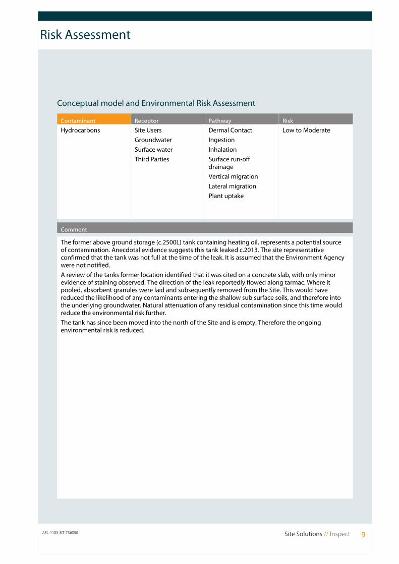
Conceptual model and Environmental Risk Assessment
Contaminant Receptor Pathway Risk
Hydrocarbons Site Users
Groundwater
Surface water
Third Parties
Dermal Contact
Ingestion
Inhalation
Surface run-off drainage
Vertical migration
Lateral migration
Plant uptake
Low to Moderate
Comment
The former above ground storage (c.2500L) tank containing heating oil, represents a potential source of contamination. Anecdotal evidence suggests this tank leaked c.2013. The site representative confirmed that the tank was not full at the time of the leak. It is assumed that the Environment Agency were not notified.
A review of the tanks former location identified that it was cited on a concrete slab, with only minor evidence of staining observed. The direction of the leak reportedly flowed along tarmac. Where it pooled, absorbent granules were laid and subsequently removed from the Site. This would have reduced the likelihood of any contaminants entering the shallow sub surface soils, and therefore into the underlying groundwater. Natural attenuation of any residual contamination since this time would reduce the environmental risk further.
The tank has since been moved into the north of the Site and is empty. Therefore the ongoing environmental risk is reduced.
AEL-1103-SIT-736350 Site Solutions // Inspect 9
Risk Assessment
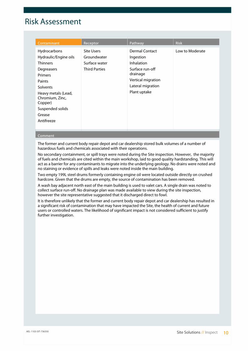
Contaminant Receptor Pathway Risk
Hydrocarbons
Hydraulic/Engine oils
Thinners
Degreasers
Primers
Paints
Solvents
Heavy metals (Lead, Chromium, Zinc, Copper)
Suspended solids
Grease
Antifreeze
Site Users
Groundwater
Surface water
Third Parties
Dermal Contact
Ingestion
Inhalation
Surface run-off drainage
Vertical migration
Lateral migration
Plant uptake
Low to Moderate
Comment
The former and current body repair depot and car dealership stored bulk volumes of a number of hazardous fuels and chemicals associated with their operations.
No secondary containment, or spill trays were noted during the Site inspection. However, the majority of fuels and chemicals are cited within the main workshop, laid to good quality hardstanding. This will act as a barrier for any contaminants to migrate into the underlying geology. No drains were noted and no staining or evidence of spills and leaks were noted inside the main building.
Two empty 199L steel drums formerly containing engine oil were located outside directly on crushed hardcore. Given that the drums are empty, the source of contamination has been removed.
A wash bay adjacent north east of the main building is used to valet cars. A single drain was noted to collect surface run-off. No drainage plan was made available to view during the site inspection, however the site representative suggested that it discharged direct to fowl.
It is therefore unlikely that the former and current body repair depot and car dealership has resulted in a significant risk of contamination that may have impacted the Site, the health of current and future users or controlled waters. The likelihood of significant impact is not considered sufficient to justify further investigation.
AEL-1103-SIT-736350 Site Solutions // Inspect 10

Data
Tabular Summary
Statutory Information On-site 1-250m 251-500m
Local Authority Pollution Prevention and Controls 0 2 0
Local Authority Integrated Pollution Prevention and Controls
0 0 0
Integrated Pollution Controls 0 0 0
Integrated Pollution Prevention And Control 0 0 0
Registered Radioactive Substances 0 0 0
Discharge Consents 0 1 2
Water Industry Act Referrals 0 0 0
Control of Major Accident Hazards Sites 0 0 0
Explosive Sites 0 0 0
Notification of Installations Handling Hazardous Substances
0 0 0
Planning Hazardous Substance Consents 0 0 0
Contaminated Land Register Entries and Notices 0 0 0
Local Authority Pollution Prevention and Control Enforcements
0 0 0
Enforcement and Prohibition Notices 0 0 0
Planning Hazardous Substance Enforcements 0 0 0
Substantiated Pollution Incident Register 0 0 0
Prosecutions Relating to Authorised Processes 0 0 0
Prosecutions Relating to Controlled Waters 0 0 0
Waste On-site 1-250m 251-500m *(501 - 750m)
BGS Recorded Landfill Sites 0 0 0 (0) *
Integrated Pollution Control Registered Waste Sites 0 0 0
Licenced Waste Management Facilities (Landfill Boundaries)
0 0 0
Licenced Waste Management Facilities (Locations) 0 0 0 (0) *
Local Authority Recorded Landfill Sites 0 0 0 (0) *
Registered Landfill Sites 0 0 0 (0) *
Registered Waste Transfer Sites 0 0 0
Registered Waste Treatment or Disposal Sites 0 0 0
Historical Landfill Sites 0 0 0
Current Land Use On-site 1-250m 251-500m
Contemporary Trade Directory Entries 0 15 5
Fuel Station Entries 0 1 0
Telecommunication Base Stations 0 2 0
AEL-1103-TSC-704624 Site Solutions // Inspect 14,
Risk Assessment
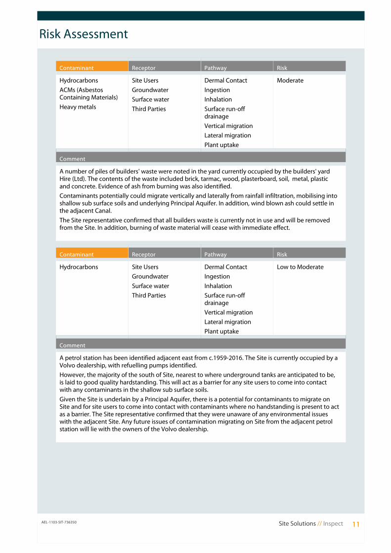
Contaminant Receptor Pathway Risk
Hydrocarbons
ACMs (Asbestos Containing Materials)
Heavy metals
Site Users
Groundwater
Surface water
Third Parties
Dermal Contact
Ingestion
Inhalation
Surface run-off drainage
Vertical migration
Lateral migration
Plant uptake
Moderate
Comment
A number of piles of builders' waste were noted in the yard currently occupied by the builders' yard Hire (Ltd). The contents of the waste included brick, tarmac, wood, plasterboard, soil, metal, plastic and concrete. Evidence of ash from burning was also identified.
Contaminants potentially could migrate vertically and laterally from rainfall infiltration, mobilising into shallow sub surface soils and underlying Principal Aquifer. In addition, wind blown ash could settle in the adjacent Canal.
The Site representative confirmed that all builders waste is currently not in use and will be removed from the Site. In addition, burning of waste material will cease with immediate effect.
Contaminant Receptor Pathway Risk
Hydrocarbons Site Users
Groundwater
Surface water
Third Parties
Dermal Contact
Ingestion
Inhalation
Surface run-off drainage
Vertical migration
Lateral migration
Plant uptake
Low to Moderate
Comment
A petrol station has been identified adjacent east from c.1959-2016. The Site is currently occupied by a Volvo dealership, with refuelling pumps identified.
However, the majority of the south of Site, nearest to where underground tanks are anticipated to be, is laid to good quality hardstanding. This will act as a barrier for any site users to come into contact with any contaminants in the shallow sub surface soils.
Given the Site is underlain by a Principal Aquifer, there is a potential for contaminants to migrate on Site and for site users to come into contact with contaminants where no handstanding is present to act as a barrier. The Site representative confirmed that they were unaware of any environmental issues with the adjacent Site. Any future issues of contamination migrating on Site from the adjacent petrol station will lie with the owners of the Volvo dealership.
AEL-1103-SIT-736350 Site Solutions // Inspect 11
Data
Contents of the Data Section
Tabular Summary This section presents a tabular summary of information found for the Site and surrounding area. The data is presented in three buffer zones for ease of reference: data found at the Site, from 1-250m and from 251-500m.
If a database has been searched the number of records found will be displayed under the relevant search band. If a database is not available or has not been searched, this will be represented by the abbreviation N/A under the relevant search band.
Current Land Use This section provides information on current land uses and is divided into three sections, statutory information, waste and current industrial uses. It is preceded by two maps.
The accurate large-scale Site Layout Plan confirms the Site boundary with statutory, waste and current land use information presented within 250m.
The smaller scale map Site Location Map presents the Site’s setting and statutory, waste and current land use information within 500m of the Site boundary.
Statutory Information
This section presents detailed statutory information for the Site and surrounding area (up to 500m depending upon dataset). The Map ID of each feature is indicated (where applicable) followed by specific information on each feature and its distance and direction from the Site.
Waste This section presents detailed information on waste and landfill sites for the Site and surrounding area (up to 500m depending upon dataset). The Map ID of each feature is indicated (where applicable) followed by specific information on each feature and its distance and direction from the Site.
Current Industrial Land Use
This section presents detailed information on current land use for the Site and surrounding area (0-250m). The Map ID of each feature is indicated (where applicable) followed by specific information on each feature and its distance and direction from the Site.
Historical Land Use This section presents selected information on historical land use for the Site and surrounding area (0-500m). These features are not mapped. A table listing the historical maps used in the risk assessment is also provided.
Aquifer Designations and Geology
This section is preceded by two maps that present information relating to the aquifer designations beneath the Site. The first of these maps indicates the designation of the Superficial geology. The second map presents the aquifer designation of the solid geology.
These maps are followed by detailed information in relation to aquifer designations/groundwater vulnerability and geology at the Site and surrounding area (0-500m).
AEL-1103-TSC-704624 Site Solutions // Inspect 12,

Data
Environmental Sensitivity
This section presents detailed information on the environmental sensitivity of the Site and surrounding area (up to 500m depending upon dataset) and is preceded by two maps. The first shows areas with statutory designations, the second shows source protection zones. The Map ID of each feature is indicated (where applicable) followed by specific information on each feature and its distance and direction from the Site.
Natural and Mining Related Hazards
This section contains information on natural and mining related hazards which may affect the Site. These include subsidence, radon and mining.
© Landmark Information Group Limited 2016. All Rights Reserved. The copyright on the information and data as contained in the Data section of
this Report ("Report") is the property of Landmark Information Group Limited ("Landmark") and several other Data Providers, including (but not
limited to) Ordnance Survey, British Geological Survey, the Environment Agency and English Nature, and must not be reproduced in whole or in part
by photocopying or any other method.
AEL-1103-TSC-704624 Site Solutions // Inspect 13,
Data
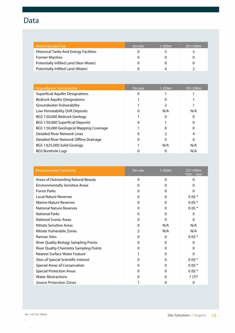
Historical Land Use On-site 1-250m 251-500m
Historical Tanks And Energy Facilities 0 5 3
Former Marshes 0 0 0
Potentially Infilled Land (Non-Water) 0 0 0
Potentially Infilled Land (Water) 0 4 2
Groundwater Vulnerability On-site 1-250m 251-500m
Superficial Aquifer Designations 0 1 1
Bedrock Aquifer Designations 1 0 1
Groundwater Vulnerability 1 2 1
Low Permeability Drift Deposits 0 N/A N/A
BGS 1:50,000 Bedrock Geology 1 0 0
BGS 1:50,000 Superficial Deposits 0 1 0
BGS 1:50,000 Geological Mapping Coverage 1 0 0
Detailed River Network Lines 0 2 4
Detailed River Network Offline Drainage 0 0 0
BGS 1:625,000 Solid Geology 1 N/A N/A
BGS Borehole Logs 0 0 N/A
Environmental Sensitivity On-site 1-250m 251-500m *(501 - 1km)
Areas of Outstanding Natural Beauty 0 0 0
Environmentally Sensitive Areas 0 0 0
Forest Parks 0 0 0
Local Nature Reserves 0 0 0 (0) *
Marine Nature Reserves 0 0 0 (0) *
National Nature Reserves 0 0 0 (0) *
National Parks 0 0 0
National Scenic Areas 0 0 0
Nitrate Sensitive Areas 0 N/A N/A
Nitrate Vulnerable Zones 2 N/A N/A
Ramsar Sites 0 0 0 (0) *
River Quality Biology Sampling Points 0 0 0
River Quality Chemistry Sampling Points 0 0 0
Nearest Surface Water Feature 1 0 0
Sites of Special Scientific Interest 0 0 0 (0) *
Special Areas of Conservation 0 0 0 (0) *
Special Protection Areas 0 0 0 (0) *
Water Abstractions 0 0 1 (7)*
Source Protection Zones 1 0 0
AEL-1103-TSC-704624 Site Solutions // Inspect 15,
Data
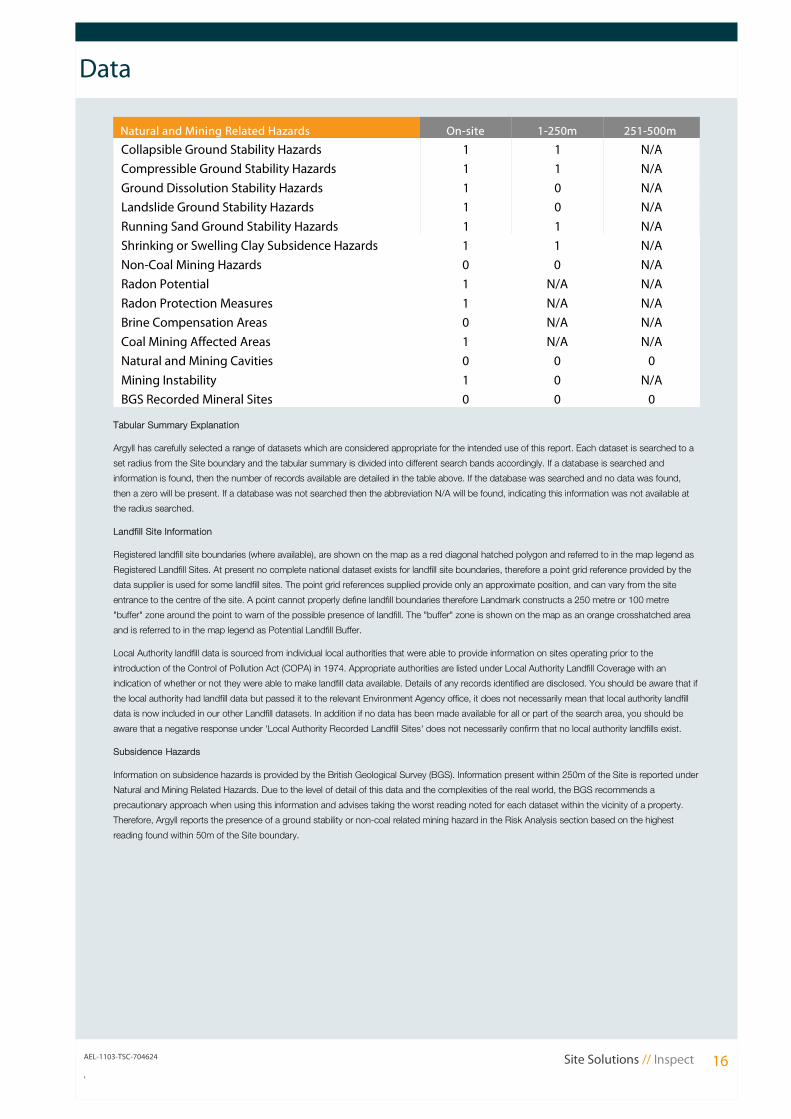
Natural and Mining Related Hazards On-site 1-250m 251-500m
Collapsible Ground Stability Hazards 1 1 N/A
Compressible Ground Stability Hazards 1 1 N/A
Ground Dissolution Stability Hazards 1 0 N/A
Landslide Ground Stability Hazards 1 0 N/A
Running Sand Ground Stability Hazards 1 1 N/A
Shrinking or Swelling Clay Subsidence Hazards 1 1 N/A
Non-Coal Mining Hazards 0 0 N/A
Radon Potential 1 N/A N/A
Radon Protection Measures 1 N/A N/A
Brine Compensation Areas 0 N/A N/A
Coal Mining Affected Areas 1 N/A N/A
Natural and Mining Cavities 0 0 0
Mining Instability 1 0 N/A
BGS Recorded Mineral Sites 0 0 0
Tabular Summary Explanation
Argyll has carefully selected a range of datasets which are considered appropriate for the intended use of this report. Each dataset is searched to a
set radius from the Site boundary and the tabular summary is divided into different search bands accordingly. If a database is searched and
information is found, then the number of records available are detailed in the table above. If the database was searched and no data was found,
then a zero will be present. If a database was not searched then the abbreviation N/A will be found, indicating this information was not available at
the radius searched.
Landfill Site Information
Registered landfill site boundaries (where available), are shown on the map as a red diagonal hatched polygon and referred to in the map legend as
Registered Landfill Sites. At present no complete national dataset exists for landfill site boundaries, therefore a point grid reference provided by the
data supplier is used for some landfill sites. The point grid references supplied provide only an approximate position, and can vary from the site
entrance to the centre of the site. A point cannot properly define landfill boundaries therefore Landmark constructs a 250 metre or 100 metre
"buffer" zone around the point to warn of the possible presence of landfill. The "buffer" zone is shown on the map as an orange crosshatched area
and is referred to in the map legend as Potential Landfill Buffer.
Local Authority landfill data is sourced from individual local authorities that were able to provide information on sites operating prior to the
introduction of the Control of Pollution Act (COPA) in 1974. Appropriate authorities are listed under Local Authority Landfill Coverage with an
indication of whether or not they were able to make landfill data available. Details of any records identified are disclosed. You should be aware that if
the local authority had landfill data but passed it to the relevant Environment Agency office, it does not necessarily mean that local authority landfill
data is now included in our other Landfill datasets. In addition if no data has been made available for all or part of the search area, you should be
aware that a negative response under 'Local Authority Recorded Landfill Sites' does not necessarily confirm that no local authority landfills exist.
Subsidence Hazards
Information on subsidence hazards is provided by the British Geological Survey (BGS). Information present within 250m of the Site is reported under
Natural and Mining Related Hazards. Due to the level of detail of this data and the complexities of the real world, the BGS recommends a
precautionary approach when using this information and advises taking the worst reading noted for each dataset within the vicinity of a property.
Therefore, Argyll reports the presence of a ground stability or non-coal related mining hazard in the Risk Analysis section based on the highest
reading found within 50m of the Site boundary.
AEL-1103-TSC-704624 Site Solutions // Inspect 16,