sitesolutions energy & infrastructure · system covering a larger area of land. this report...
TRANSCRIPT

SiteSolutions Energy & Infrastructure
This report is issued for the property described as:Energy
Oil and Gas Exploration IDENTIFIEDTestTestTest TownTE1 1ST
Report Reference100207120
Customer ReferenceUAT Test 001 25/11/16_HS2
Report produced on25 November 2016
Wind Energy NOT IDENTIFIED
Solar Energy IDENTIFIED
Other Renewable Energy NOT IDENTIFIED
Infrastructure
High Speed 2 NOT IDENTIFIED
Crossrail 1 NOT IDENTIFIED
CONTACT DETAILS-----------------------------------------If you require assistance please contact our customer services team on:
0844 844 9966-----------------------------------------or by email at:[email protected]
The Responsible Authority for the site is:Wiltshire Council
Energy & Infrastructure Report
Understanding this report
We have designed this report for home owners, business owners, or those purchasing a home or business. It complements other planning reports by alerting users to energy and infrastructure projects.
The projects and developments we check for cover the whole of the UK. We have split it into two sections: Energy and Infrastructure. There will be maps and data for each individual development or project that has been identified.
The developments and projects included have the potentialto affect nearby property values. They could result in addedvisual impact or noise to the neighbourhood. The impact on property values may also be positive. For instance, being near a new rail link may boost values in the local area.
We check each project or development against your property to the distance described to the right. If we find something nearby we will display "IDENTIFIED" on the front page.
If we don't find anything we will display "NOT IDENTIFIED".
We will only describe issues relevant to the property in this report. By excluding unnecessary information, we hope you find the report easier to understand.
Alert Distances
The distance we search from your property for each development follows independent expert guidance.
The following projects/developments and corresponding alert distances are searched for:
Energy
Oil and gas exploration blocks (current) – to 4kmOil and gas exploration blocks (offered) – to 4kmOil and gas drilling well locations – to 4kmWind farms and turbines – to 4kmSolar farms – to 2kmRenewable power plants – to 2km
We use planning applications data for wind, solar and other renewable energy developments. The data only includes energy developments with a capacity to produce over 1MW of power. The report will only show "IDENTIFIED" on the front page if the planning application is active. We will still provide details of the inactive applications. These are applications that have been refused, withdrawn, abandoned etc.
Infrastructure
High Speed 2 – to 4km in rural areas and 2km in urban areasCrossrail 1 – to 2km (Crossrail 2 is not included)
Next Steps:If any of the developments or projects included in this report have been identified you should follow the advice detailed in the recommendations on the next page.For help with the report contact our Customer Services Team on 0844 844 9966 or email [email protected]
Site Solutions // Energy & Infrastructure
Recommendations
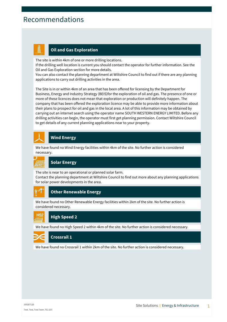
Oil and Gas Exploration
The site is within 4km of one or more drilling locations.If the drilling well location is current you should contact the operator for further information. See the Oil and Gas Exploration section for more details.You can also contact the planning department at Wiltshire Council to find out if there are any planning applications to carry out drilling activities in the area.
The Site is in or within 4km of an area that has been offered for licensing by the Department for Business, Energy and Industry Strategy (BEIS)for the exploration of oil and gas. The presence of one or more of these licences does not mean that exploration or production will definitely happen. The company that has been offered the exploration licence may be able to provide more information abouttheir plans to prospect for oil and gas in the local area. A lot of this information may be obtained by carrying out an internet search using the operator name SOUTH WESTERN ENERGY LIMITED. Before anydrilling activities can begin, the operator must first get planning permission. Contact Wiltshire Council to get details of any current planning applications near to your property.
Wind Energy
We have found no Wind Energy facilities within 4km of the site. No further action is considered necessary.
Solar Energy
The site is near to an operational or planned solar farm.Contact the planning department at Wiltshire Council to find out more about any planning applicationsfor solar power developments in the area.
Other Renewable Energy
We have found no Other Renewable Energy facilities within 2km of the site. No further action is considered necessary.
High Speed 2
We have found no High Speed 2 within 4km of the site. No further action is considered necessary.
Crossrail 1
We have found no Crossrail 1 within 2km of the site. No further action is considered necessary.
100207120 Site Solutions // Energy & Infrastructure 1Test, Test, Test Town, TE1 1ST
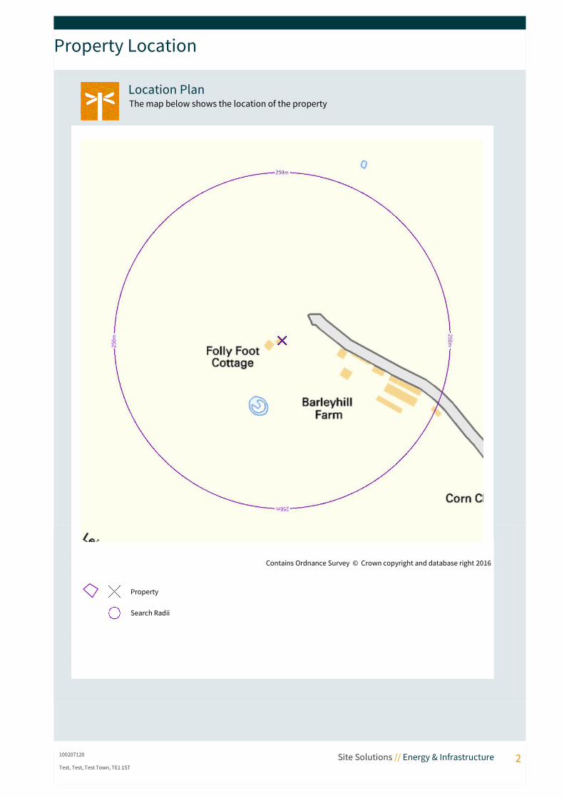
Property Location
Location PlanThe map below shows the location of the property
100207120 Site Solutions // Energy & Infrastructure 2Test, Test, Test Town, TE1 1ST
Contains Ordnance Survey © Crown copyright and database right 2016
Property
Search Radii
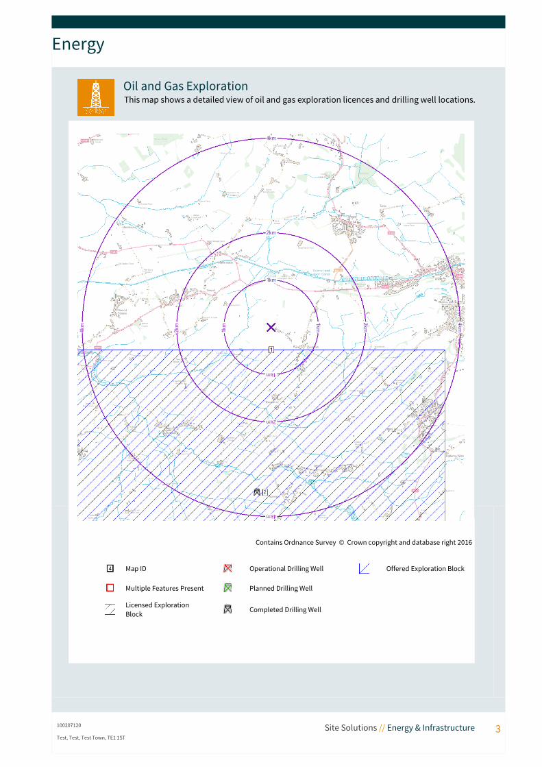
Energy
Oil and Gas ExplorationThis map shows a detailed view of oil and gas exploration licences and drilling well locations.
100207120 Site Solutions // Energy & Infrastructure 3Test, Test, Test Town, TE1 1ST
Contains Ordnance Survey © Crown copyright and database right 2016
Map ID Operational Drilling Well Offered Exploration Block
Multiple Features Present Planned Drilling Well
Licensed Exploration Block Completed Drilling Well

Energy
Drilling well locations within 4km of your property
Map ID Drilling Well Locations Status Distance
2 Licence: PL120Type: Conventional Oil and GasOperator: ULSTERName: Devizes 1Number: Lp/25- 1End date: 15th September 1972
Completed 3503m S
Offered Exploration licences within 4km of your property
Map ID Exploration Licences Status Distance
1 Block Reference: ST95Energy Type: Coalbed MethaneLicensee: SOUTH WESTERN ENERGY LIMITEDPartners: SOUTH WESTERN ENERGY LIMITED
- 478m S
What is it?Onshore oil and gas exploration and production licences relate to areas of land (blocks). The presence of one or more of these licences does not mean that exploration or production will definitely happen. The Department for Business, Energy, & Industrial Strategy (BEIS) grants the licences to operators. They must show technical and environmental competence and have access to funding. The government does not directly grant access rights. Planning permission must be sought from the Local Authority. Environmental permits must also be sought from the Environment Agency, Scottish Environment Protection Agency, or Natural Resources Wales.
As well as the areas currently licensed for oil and gas exploration, we will also show the 159 new licenses that were recently offered under the 14th Onshore Oil and Gas Licensing Round to successful applicants.
We also provide details of all drilling wells. The following different types of drilling well are reported:• for shale gas• for gas storage• for methane gas• for coalbed methane• for conventional oil and gasOil and gas companies use a variety of methods to extract fuel gases from the ground. The method used depends on how freely the gas is able to move within the rock. The more freely it can move the easier it is to collect. Much of the gas reserves in the UK are locked up in fine-grained sediments several hundred metres below ground. Hydraulic fracturing or “fracking” is one of the methods that can be used to access it. The fracking process involves injecting water and various other additives into the ground. Fracking has been employed in the USA for some time and is only now beginning to develop in the UK. Some negative media coverage of the process has occurred in the USA. The differences in regulatory regime and geological conditions mean that direct comparison of the UK with the USA is not strictly applicable. A number of reports have been produced by proponents and opponents of the technology in the UK and Europe, with a small number of expert technical reports leading government and regulatory policy towards shale gas development in the UK. However, regulatory advice is currently limited.
100207120 Site Solutions // Energy & Infrastructure 4Test, Test, Test Town, TE1 1ST
Energy
What could be the impact on your property?There is general consensus that risks to property from fracking are low. The exact nature of risk depends upon site specific considerations. Fracking is just one technical part of the process required for the development and operation of a shale gas operation. This includes exploration, production and abandonment. Each stage of the shale gas development process presents a different set of risks. These include contamination risk to groundwater and surface water, seismic risks, and amenity risks (for example, from increased traffic movements). The nature of risk depends upon both the impact should an event occur and the likelihood of it occurring. Some guidance has been produced in relation to shale gas by UK Government and environmental regulators. It is likely that significantly more will follow before commercial shale gas operations commence at any significant scale.
What can you do about it?All oil and gas operations will require appropriate planning consent, during which process local residents and interested parties have the right to comment on any application. If you are worried about a development close to your property you should contact the Planning Department at Wiltshire Council for more information. The company that holds the exploration licence may be able to provide more information about their plans to prospect for oil and gas in the local area. A lot of this information can be obtained by carrying out an internet search using the licence reference number. If not, you can try to contact the operator by phone, email, or post.
100207120 Site Solutions // Energy & Infrastructure 5Test, Test, Test Town, TE1 1ST
Energy
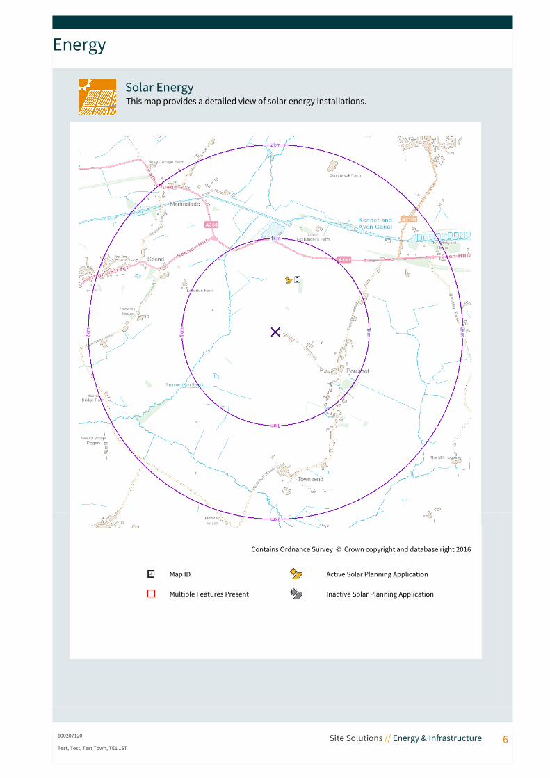
Solar EnergyThis map provides a detailed view of solar energy installations.
100207120 Site Solutions // Energy & Infrastructure 6Test, Test, Test Town, TE1 1ST
Contains Ordnance Survey © Crown copyright and database right 2016
Map ID Active Solar Planning Application
Multiple Features Present Inactive Solar Planning Application
Energy
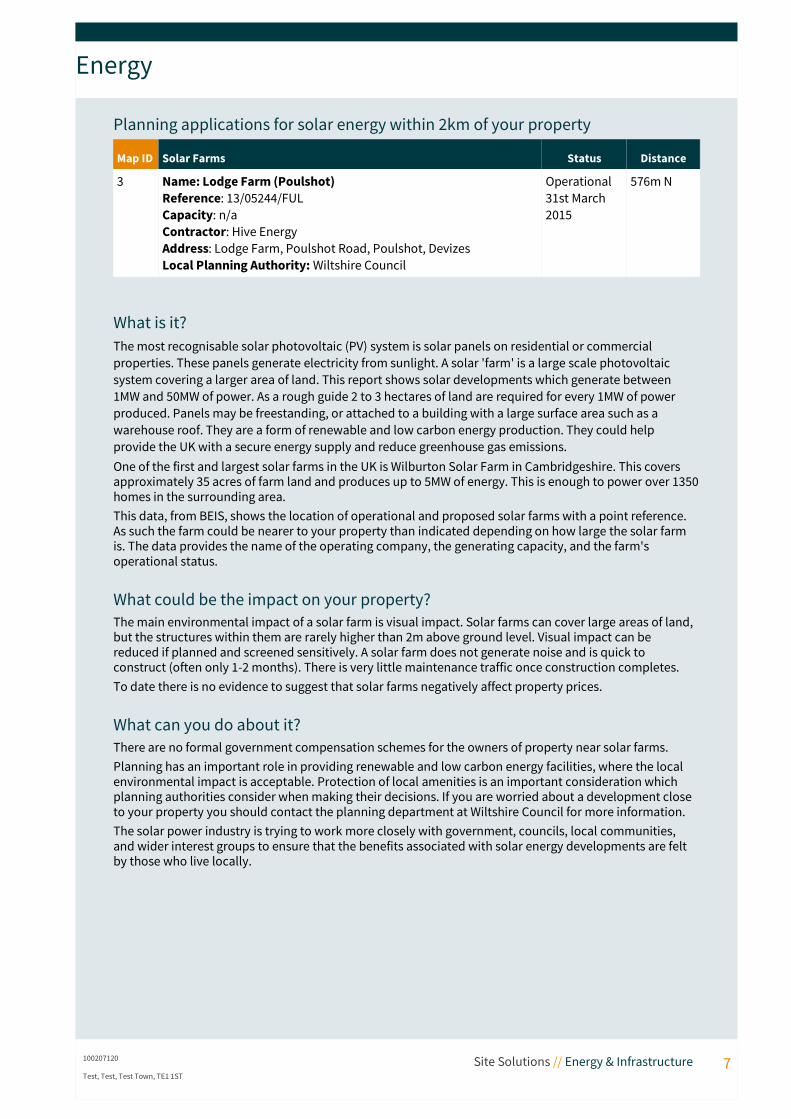
Planning applications for solar energy within 2km of your property
Map ID Solar Farms Status Distance
3 Name: Lodge Farm (Poulshot)Reference: 13/05244/FULCapacity: n/aContractor: Hive EnergyAddress: Lodge Farm, Poulshot Road, Poulshot, DevizesLocal Planning Authority: Wiltshire Council
Operational 31st March 2015
576m N
What is it?The most recognisable solar photovoltaic (PV) system is solar panels on residential or commercial properties. These panels generate electricity from sunlight. A solar 'farm' is a large scale photovoltaic system covering a larger area of land. This report shows solar developments which generate between 1MW and 50MW of power. As a rough guide 2 to 3 hectares of land are required for every 1MW of power produced. Panels may be freestanding, or attached to a building with a large surface area such as a warehouse roof. They are a form of renewable and low carbon energy production. They could help provide the UK with a secure energy supply and reduce greenhouse gas emissions.One of the first and largest solar farms in the UK is Wilburton Solar Farm in Cambridgeshire. This covers approximately 35 acres of farm land and produces up to 5MW of energy. This is enough to power over 1350homes in the surrounding area.This data, from BEIS, shows the location of operational and proposed solar farms with a point reference. As such the farm could be nearer to your property than indicated depending on how large the solar farm is. The data provides the name of the operating company, the generating capacity, and the farm's operational status.
What could be the impact on your property?The main environmental impact of a solar farm is visual impact. Solar farms can cover large areas of land, but the structures within them are rarely higher than 2m above ground level. Visual impact can be reduced if planned and screened sensitively. A solar farm does not generate noise and is quick to construct (often only 1-2 months). There is very little maintenance traffic once construction completes.To date there is no evidence to suggest that solar farms negatively affect property prices.
What can you do about it?There are no formal government compensation schemes for the owners of property near solar farms. Planning has an important role in providing renewable and low carbon energy facilities, where the local environmental impact is acceptable. Protection of local amenities is an important consideration which planning authorities consider when making their decisions. If you are worried about a development close to your property you should contact the planning department at Wiltshire Council for more information. The solar power industry is trying to work more closely with government, councils, local communities, and wider interest groups to ensure that the benefits associated with solar energy developments are felt by those who live locally.
100207120 Site Solutions // Energy & Infrastructure 7Test, Test, Test Town, TE1 1ST
Useful Contacts
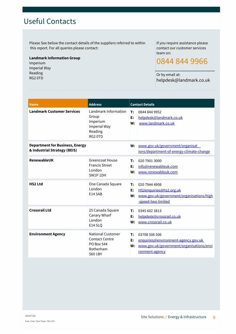
Please See below the contact details of the suppliers referred to within this report. For all queries please contact:
Landmark Information GroupImperiumImperial WayReadingRG2 0TD
If you require assistance please contact our customer services team on:
0844 844 9966Or by email at:[email protected]
Name Address Contact Details
Landmark Customer Services Landmark Information GroupImperiumImperial WayReadingRG2 0TD
T:E:W:
0844 844 [email protected] www.landmark.co.uk
Department for Business, Energy& Industrial Strategy (BEIS)
W: www.gov.uk/government/organisat ions/department-of-energy-climate-change
RenewableUK Greencoat House Francis Street LondonSW1P 1DH
T:E:W:
020 7901 [email protected]
HS2 Ltd One Canada SquareLondon E14 5AB
T:E:W:
020 7944 [email protected]/government/organisations/high-speed-two-limited
Crossrail Ltd 25 Canada SquareCanary WharfLondonE14 5LQ
T:E:W:
0345 602 3813 [email protected]
Environment Agency National Customer Contact CentrePO Box 544RotherhamS60 1BY
T:E:W:
03708 506 [email protected] www.gov.uk/government/organisations/environment-agency
100207120 Site Solutions // Energy & Infrastructure 8Test, Test, Test Town, TE1 1ST

Useful Information
Data Sources
Oil and Gas Exploration
Department for Business, Energy, & Industrial Strategy (BEIS) 2016. Contains public sector information licensed under the Open Government Licence v1.0
Wind Energy RenewableUK and OS Landline Mapping, June 2013, Department for Business, Energy, & Industrial Strategy (BEIS) 2016. Contains public sector information licensedunder the Open Government Licence v1.0
Solar Energy Department for Business, Energy, & Industrial Strategy (BEIS) 2016. Contains public sector information licensed under the Open Government Licence v1.0
Renewable PowerPlants
Department for Business, Energy, & Industrial Strategy (BEIS) 2016. Contains public sector information licensed under the Open Government Licence v1.0
High Speed 2 HS2 Ltd, July/August/November 2013. Contains public sector information licensed under the Open Government Licence v1.0
Crossrail 1 Crossrail Ltd, January 2012
Limitations of the ReportThe Energy and Infrastructure Report has been designed to satisfy standard due-diligence enquiries for residential and commercial sites. It is a ‘remote’ investigation and reviews databases of publicly available information that have been chosen to enable a desk-based analysis of key infrastructure projects. The report does not include data on all UK energy and Infrastructure projects, nor does Argyll make specific information requests of the regulatory authorities for any relevant information they may hold. Therefore, Argyll cannot guarantee that all land uses or factors of concern will have been identified by the report.Argyll Environmental is unable to comment directly with regards to the potential effect these key energy or infrastructure projects will have on the value of nearby properties. We would recommend contacting anappropriate surveyor who can provide a valuation.While every effort is made to ensure accuracy, Argyll cannot guarantee the accuracy or completeness of such information or data. We do not accept responsibility for inaccurate data provided by external data providers.For further information regarding the datasets reviewed within our analysis, please contact our customer services team on 0844 844 9966. This report is provided under the Argyll Environmental Terms and Conditions for Data Reports, a copy of which is available on our website.
Terms and ConditionsFull terms and conditions can be found on the following link: https://lmkargyll1.s3.amazonaws.com/s3fs-public/tc_dp_3-3_new_address.pdf
100207120 Site Solutions // Energy & Infrastructure 9Test, Test, Test Town, TE1 1ST

Search Code
Important Consumer Protection InformationThis search has been produced by Argyll Environmental Ltd, 1st Floor, 98 – 99 Queens Road, Brighton, BN1 3XF. Tel: 0845 458 5250. Email: [email protected] which is registered with the Property Codes Compliance Board (PCCB) as a subscriber to the Search Code. The PCCB independently monitors how registered search firms maintain compliance with the Code.
The Search Code:• provides protection for homebuyers, sellers, estate agents, conveyancers and mortgage lenders
who rely on the information included in property search reports undertaken by subscribers on residential and commercial property within the United Kingdom
• sets out minimum standards which firms compiling and selling search reports have to meet• promotes the best practice and quality standards within the industry for the benefit of consumers
and property professionals• enables consumers and property professionals to have confidence in firms which subscribe to the
code, their products and services.By giving you this information, the search firm is confirming that they keep to the principles of the Code. This provides important protection for you.
The Code's core principlesFirms which subscribe to the Search Code will:
• display the Search Code logo prominently on their search reports• act with integrity and carry out work with due skill, care and diligence• at all times maintain adequate and appropriate insurance to protect consumers• conduct business in an honest, fair and professional manner• handle complaints speedily and fairly• ensure that products and services comply with industry registration rules and standards and
relevant laws• monitor their compliance with the Code
ComplaintsIf you have a query or complaint about your search, you should raise it directly with the search firm, and if appropriate ask for any complaint to be considered under their formal internal complaints procedure. If you remain dissatisfied with the firm’s final response, after your complaint has been formally considered, or if the firm has exceeded the response timescales, you may refer your complaint for consideration under The Property Ombudsman scheme (TPOs). The Ombudsman can award up to £5,000 to you if the Ombudsman finds that you have suffered actual financial loss and/or aggravation , distress or inconvenience as a result of your search provider failing to keep to the Code.Please note that all queries or complaints regarding your search should be directed to your search provider in the first instance, not to TPOs or to the PCCB.TPOs Contact Details:
The Property Ombudsman schemeMilford House43-55 Milford StreetSalisburyWiltshire SP1 2BPTel: 01722 333306Fax: 01722 332296Web site www.tpos.co.ukEmail: [email protected]
100207120 Site Solutions // Energy & Infrastructure 10Test, Test, Test Town, TE1 1ST
Search Code
You can get more information about the PCCB from www.propertycodes.org.ukPLEASE ASK YOUR SEARCH PROVIDER IF YOU WOULD LIKE A COPY OF THE SEARCH CODE
Complaints procedureIf you want to make a complaint, we will:
• Acknowledge it within 5 working days of receipt• Normally deal with it fully and provide a final response, in writing, within 20 working days of
receipt• Keep you informed by letter, telephone or e-mail, as you prefer, if we need more time• Provide a final response, in writing, at the latest within 40 working days of receipt• Liaise, at your request, with anyone acting formally on your behalf
Complaints should be sent to:Legal DirectorArgyll Environmental Ltd1st Floor98 – 99 Queens RoadBrightonBN1 3XF
Tel: 0845 458 5250Email: [email protected]
If you are not satisfied with our final response, or if we exceed the response timescales, you may refer the complaint to The Property Ombudsman scheme (TPOs): Tel: 01722 333306, Email: [email protected]
We will co-operate fully with the Ombudsman during an investigation and comply with his final decision.
100207120 Site Solutions // Energy & Infrastructure 11Test, Test, Test Town, TE1 1ST