sitesolutions combined
TRANSCRIPT
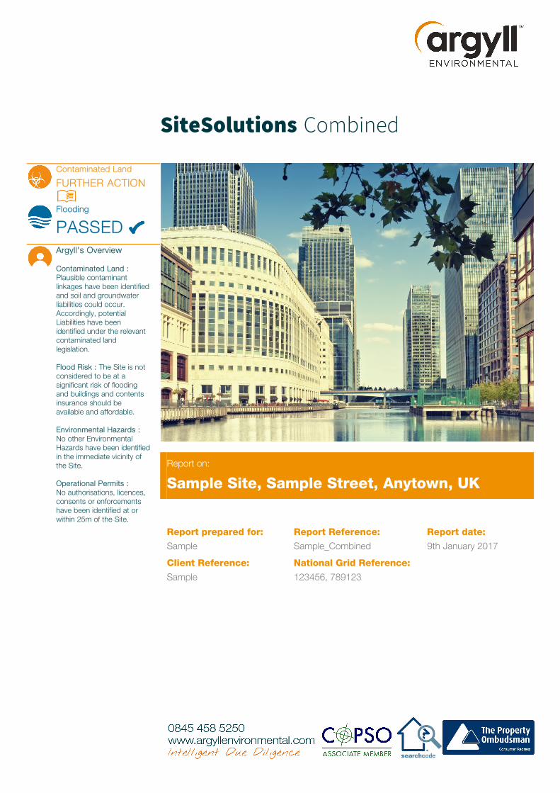
SiteSolutions Combined
Contaminated Land
FURTHER ACTION
Flooding
PASSEDArgyll's Overview
Contaminated Land : Plausible contaminant linkages have been identifiedand soil and groundwater liabilities could occur. Accordingly, potential Liabilities have been identified under the relevant contaminated land legislation.
Flood Risk : The Site is not considered to be at a significant risk of flooding and buildings and contents insurance should be available and affordable.
Environmental Hazards :No other Environmental Hazards have been identified in the immediate vicinity of the Site.
Operational Permits :No authorisations, licences, consents or enforcements have been identified at or within 25m of the Site.
Report on:
Sample Site, Sample Street, Anytown, UK
Report prepared for:
Sample
Client Reference:
Sample
Report Reference:
Sample_Combined
National Grid Reference:
123456, 789123
Report date:
9th January 2017
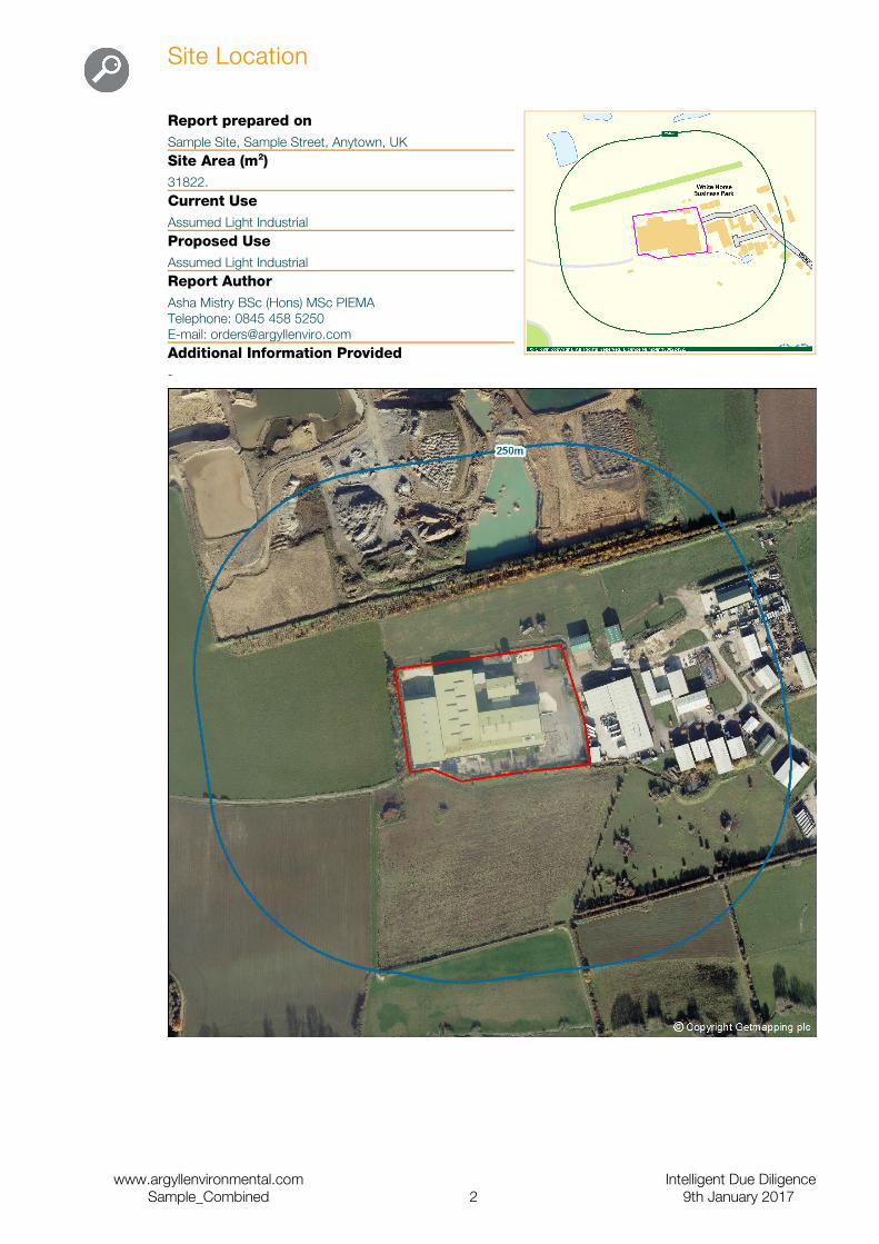
Site Location
Report prepared onSample Site, Sample Street, Anytown, UKSite Area (m2)31822.Current UseAssumed Light Industrial Proposed UseAssumed Light IndustrialReport AuthorAsha Mistry BSc (Hons) MSc PIEMATelephone: 0845 458 5250E-mail: [email protected] Information Provided-
www.argyllenvironmental.com Intelligent Due DiligenceSample_Combined 2 9th January 2017
Executive Summary
RiskEvaluation
Contaminated Land
Further action
Liability Assessment
Potential Liabilities have been identified under Part 2A of the Environmental Protection Act 1990 (or where appropriate, equivalent requirements under the planning regime) and/or the Water Resources Act 1991. To quantify these you may decide to undertake a more detailed assessment through the recommendation(s) set out below.
What is the overall on-site risk? Moderate
What is the overall off-site risk? Moderate
What is the environmental sensitivity rating? Moderate to High
Recommendations
We recommend undertaking an environmental audit at the Site, including a site inspection, staff interviews and regulatory consultation with appropriate third parties to clarify the risk presented by current and historical operations. The assessment will consider the standard of environmental management and identify potential risks associated with ground contamination in the context of the transaction at hand. An upgrade to a Site Solutions Inspect is available priced from £1255 plus VAT and including all disbursements. A report can normally be prepared in draft format within 10 working days or to your specific requirements. A finalised report can be provided following receipt of regulatory responses, which may take up to 25 working days. We would be happy to provide a detailed proposal on request. Please contact us on 0845 458 5250 if you would like further assistance.
As a minimum we would recommend regulatory consultation with the Local Authority Environmental Health and Planning Departments as outlined above to include a review of planning records for the Site, details of any past Site investigations/remediation work and relevant information concerning the Authorities strategy under Part 2A of the Environmental Protection Act 1990. An upgrade to a Site Solutions Consult is available for this Site for £405 plus VAT (includes all disbursements). This report can usually be prepared within 10-15 working days but may take up to 25 working days depending on response times.
www.argyllenvironmental.com Intelligent Due DiligenceSample_Combined 3 9th January 2017
RiskEvaluation
Flooding
Passed
Consultant's Comment
The site is not considered to be at significant risk of flooding. No further action is considered necessary. However, it would be prudent to consider the measures outlined in the Recommendations section.
1 If development is proposed would a detailed Flood Risk Assessment be required? Yes (Drainage)
2 What is the overall risk of flooding, assuming defences fail or are absent or over-topped? Low to Moderate
3 Are there existing flood defences that might benefit the Site?
No
Insurance The flood risk identified is unlikely to affect obtaining buildings and contents insurance.
Recommendations
1. You should speak to the seller to confirm whether the property or the surrounding area has flooded before. If it has, please contact us for advice.
2. Prior to exchanging contracts, establish the terms of buildings and contents insurance for the property.
www.argyllenvironmental.com Intelligent Due DiligenceSample_Combined 4 9th January 2017
Contaminated Land Risk Analysis
InvestigationCommentary
On-site sources A review of historical maps indicates the Site remained undeveloped from prior to 1878 until the 1960 map edition when it formed part of a wider disused airfield with associated units. No significant changes were noted until the 1994 map edition when an unspecified works as part of White Horse Business Park was developed. An electrical sub station and potential tanks were also noted at this time. The Site has remained in light industrial use, with an alteration to the footprint of the building noted in the 2006 and 2016 map editions. Recent aerial imagery indicates that the Site is in use as a timber merchants.
We have not been informed of the current Site use and have therefore assumed that it is in light industrial use and will continue in this use without redevelopment.
Argyll's Comment
As a result of the historical and current use of the Site, there is a moderate risk of contaminants being present.
Off-site sources A review of historical maps has revealed a number of historical or current potentially contaminative uses in proximity to the Site. These include: the wider disused airfield mentioned above c.1960-1991 and light industrial units as part of White Horse business Park from adjacent east c.1999-2016.
According to trade directories, current or recent operations in proximity to the Site include sheet metal work (24m north east). Furthermore, a Licensed Waste Management Facility categorised as an inert landfill was identified 68m north operational on 29th June 2004 which may be able to impact upon the Site.
Argyll's Comment
The historical and current use of the surrounding area is therefore considered to present a moderate risk of affecting the Site.
Pathways and receptors
With reference to Environment Agency data, the bedrock hydrogeology underlying the Site is classified as a Secondary (A) Aquifer (deposits with moderate permeability). In terms of the overlying soils, these are given a H1 (class H1) vulnerability classification.
According to information provided by the Environment Agency the Site does not lie within a groundwater Source Protection Zone (SPZ). There is one abstraction licence located within 1000m. It is a groundwater abstraction (432m north) for sand and gravel washing use. The nearest water feature (a drain) is located 6m south east.
The general area appears to be largely in light industrial use. The following designated eco-receptor was identified within 1000m: Shellingford Crossroads Quarry (Site of Special Scientific Interest) located 826m north.
Argyll'sComment
Overall, the Site is therefore considered to have a moderate to high environmental sensitivity.
Additional Sources of Information
No additional materials have been used in this assessment.
Argyll's Conclusion
Considering the information reviewed during this assessment, a number of plausible contaminant linkages have been identified. Soil and groundwater liabilities could arise whether or not redevelopment is considered.
Please refer to risk analysis methodology section for further guidance and definition of terms.
www.argyllenvironmental.com Intelligent Due DiligenceSample_Combined 5 9th January 2017
Current Operations
Environmental Damage Regulations 2009 (EDR)
Potential for owner/operation to incur a Liability under the EDR
Argyll'sComment
The Site is in close proximity to a potentially sensitive receptor as set out in the EDR. It would therefore be prudent to ensure that operations on the site are audited on a regular basis to minimisethe risk of causing environmental damage that could result in liability under the EDR. In addition, the presence of such receptors should be considered as part of any future development or activity.
Please refer to the risk analysis methodology section for further guidance and definition of terms.
Additional ConsiderationsItem
Summary Suggested ActionOperational Compliance
Such liabilities may arise if the Site is in commercial/industrial use and both the Site and the business are being purchased, or the Site is to be purchased as an investment with an operational business as a tenant.
Compliance audit
Asbestos If the buildings at the Site were constructed or renovated during the period between 1950 and 1999, then the fabric of these buildings may contain asbestos in a variety of forms.
Check the Asbestos Register and Management Plan
Energy Performance Certificate
Under the Energy Performance of Buildings (England and Wales) Regulations 2012 and the Energy Performance of Buildings (Scotland) Regulations 2008, there is a requirement for all buildings to have an Energy Performance Certificate (EPC) upon their construction, sale or lease (and in some cases when the building is modified).
Check for EPC or conduct energy assessment
Oil Storage Any oil storage facility of greater than 200 litres capacity may fall within the Oil Storage Regulations 2001.
Check tanks for secondary containment
Electrical Equipment
Prior to 1986 Polychlorinated Biphenyls (PCBs) were used as a fire retardant in cooling oils for electrical equipment. Under the Environmental Protection (Disposal of PCB and other Dangerous Substances) Regulations 2000, PCB containing equipment has been banned.
Confirm removal of PCBs or test equipment
Air Conditioning/ Refrigeration Equipment
Air conditioning and refrigeration equipment contains heat transfer fluid. This fluid may be an ozone depleting substance (ODS). Any fluid in a halon fire-extinguishing system is also a ODS.
Inspect maintenance records
Military Land Due to its former military use, if redevelopment of the Site were proposed, a desktop threat assessment would be prudent to assess the risk from unexploded ordnance.
Consider desktop threat assessment
Change of UseRedevelopment
Proposed changes in land use require permission from the Local Authority and are subject to conditions as part of the statutory planning process.
Contact local planning authority or speak with planning consultant
Argyll's Comment
Whilst this assessment is primarily a desktop assessment of potential soil and groundwater liabilities, the above potential liability considerations that fall outside the scope of the Contaminated Land Risk Analysis Methodology have been identified.
Additional sources of information may be available for the Site. These sources could include previous environmental reports (including audits, contaminated land investigation and remediation reports), valuation reports (including property observation checklists), a Land Quality Record, and property deeds. Argyll Environmental would be pleased to review any reports that are available and revise this report accordingly. This may entail additional fees depending upon the volume and complexity of information available. Please contact us for further information.
www.argyllenvironmental.com Intelligent Due DiligenceSample_Combined 6 9th January 2017
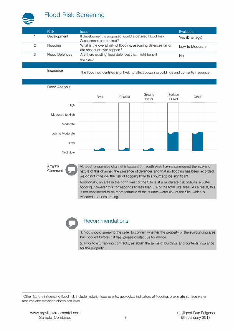
Flood Risk Screening
Risk Issue Evaluation1 Development If development is proposed would a detailed Flood Risk
Assessment be required?Yes (Drainage)
2 Flooding What is the overall risk of flooding, assuming defences fail or are absent or over-topped?
Low to Moderate
3 Flood Defences Are there existing flood defences that might benefit
the Site?No
Insurance The flood risk identified is unlikely to affect obtaining buildings and contents insurance.
Flood Analysis
River CoastalGround Water
Surface Pluvial
Other1
High
Moderate to High
Moderate
Low to Moderate
Low
Negligible
Argyll'sComment
Although a drainage channel is located 6m south east, having considered the size and nature of this channel, the presence of defences and that no flooding has been recorded, we do not consider the risk of flooding from this source to be significant.
Additionally, an area in the north west of the Site is at a moderate risk of surface water flooding, however this corresponds to less than 3% of the total Site area. As a result, this is not considered to be representative of the surface water risk at the Site, which is reflected in our risk rating.
Recommendations
1. You should speak to the seller to confirm whether the property or the surrounding area has flooded before. If it has, please contact us for advice.
2. Prior to exchanging contracts, establish the terms of buildings and contents insurance for the property.
1Other factors influencing flood risk include historic flood events, geological indicators of flooding, proximate surface water features and elevation above sea level.
www.argyllenvironmental.com Intelligent Due DiligenceSample_Combined 7 9th January 2017
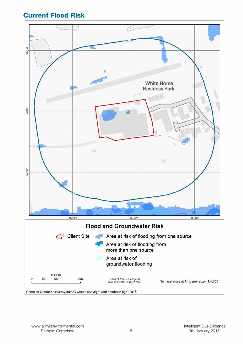
Current Flood Risk
www.argyllenvironmental.com Intelligent Due DiligenceSample_Combined 8 9th January 2017
Additional Flooding Considerations
Riparian Ownership
Is there a Main River located within or adjacent to the Site? No
Is there any other watercourse located within or adjacent to the Site? No
Argyll'sComment
A riparian owner describes anyone who owns a property where there is a watercourse within or adjacent to the boundaries of their property.
Under common law, a riparian owner has rights and responsibilities relating to the stretch of watercourse that falls within or beside the boundaries of their land. Their primary responsibility is to keep the watercourse free of any obstructions that could hinder normal water flow. If the riparian owner fails to carry out their responsibilities, this could result in civil action.
A riparian owner should also check before carrying out any works near to the edge of a river, as such works may be subject to byelaws. If infringed, this could lead to enforcement action by the Environment Agency.
There is a presumption that the boundary between properties abutting a watercourse is the centre line of that watercourse. To confirm whether this is the case, a solicitor should check the deeds or the Index Map.
The Environment Agency has published useful guidance “Living on the edge” for owners of land or property alongside a watercourse. Sometimes, the Environment Agency or other organisations managing flood risk, may have statutory rights of access to properties which adjoin a watercourse. This may be for maintenance, repair or rebuilding of any part of the watercourse or for access to or repair of monitoring equipment.
Development Control
Is there a Main River or canal located within 250m of the Site? No
Argyll'sComment
Sites which lie close to (but do not adjoin) a watercourse, may be subject to planning controls should redevelopment be considered. The Environment Agency are normally consulted regarding any development within 20m of a Main River and Internal Drainage Boards should be similarly contacted regarding developments close to drainage channels. Navigation authorities are normally consulted regarding any development within 250m of a canal, although this varies on a site by site basis.
The Environment Agency should also be contacted with regards to development (other than minor development) in Flood Zones 2 and 3.
www.argyllenvironmental.com Intelligent Due DiligenceSample_Combined 9 9th January 2017

Sewer Flooding In times of extreme rainfall events sewers can overflow and cause local flooding. Ofwat’s ‘DG5 - At Risk Registers’ record properties that have flooded from sewers and are at risk of flooding again, with separate registers for internal and external flooding. The At Risk Registers are maintained by each of the ten water and sewerage companies in England and Wales and details of properties subject to sewer flooding are normally kept for between two and five years. These registers are not necessarily complete as not all episodes of past flooding may be recorded.
Dam and Reservoir Failure
Could the Site be affected by dam or reservoir failure? No
Argyll'sComment
The answer is based on detailed models provided by JBA Risk Management. These predict the areas liable to flood around approximately 1700 key dams and reservoirs across England and Wales (if that dam or reservoir were to fail).
www.argyllenvironmental.com Intelligent Due DiligenceSample_Combined 10 9th January 2017
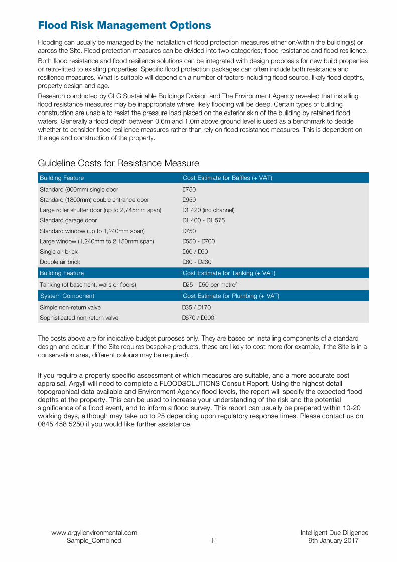
Flood Risk Management OptionsFlooding can usually be managed by the installation of flood protection measures either on/within the building(s) or across the Site. Flood protection measures can be divided into two categories; flood resistance and flood resilience.
Both flood resistance and flood resilience solutions can be integrated with design proposals for new build properties or retro-fitted to existing properties. Specific flood protection packages can often include both resistance and resilience measures. What is suitable will depend on a number of factors including flood source, likely flood depths, property design and age.
Research conducted by CLG Sustainable Buildings Division and The Environment Agency revealed that installing flood resistance measures may be inappropriate where likely flooding will be deep. Certain types of building construction are unable to resist the pressure load placed on the exterior skin of the building by retained flood waters. Generally a flood depth between 0.6m and 1.0m above ground level is used as a benchmark to decide whether to consider flood resilience measures rather than rely on flood resistance measures. This is dependent on the age and construction of the property.
Guideline Costs for Resistance MeasureBuilding Feature Cost Estimate for Baffles (+ VAT)
Standard (900mm) single door
Standard (1800mm) double entrance door
Large roller shutter door (up to 2,745mm span)
Standard garage door
Standard window (up to 1,240mm span)
Large window (1,240mm to 2,150mm span)
Single air brick
Double air brick
£750
£950
£1,420 (inc channel)
£1,400 - £1,575
£750
£550 - £700
£60 / £90
£80 - £230
Building Feature Cost Estimate for Tanking (+ VAT)
Tanking (of basement, walls or floors) £25 - £50 per metre²
System Component Cost Estimate for Plumbing (+ VAT)
Simple non-return valve
Sophisticated non-return valve
£35 / £170
£670 / £900
The costs above are for indicative budget purposes only. They are based on installing components of a standard design and colour. If the Site requires bespoke products, these are likely to cost more (for example, if the Site is in a conservation area, different colours may be required).
If you require a property specific assessment of which measures are suitable, and a more accurate cost appraisal, Argyll will need to complete a FLOODSOLUTIONS Consult Report. Using the highest detail topographical data available and Environment Agency flood levels, the report will specify the expected flood depths at the property. This can be used to increase your understanding of the risk and the potential significance of a flood event, and to inform a flood survey. This report can usually be prepared within 10-20 working days, although may take up to 25 depending upon regulatory response times. Please contact us on 0845 458 5250 if you would like further assistance.
www.argyllenvironmental.com Intelligent Due DiligenceSample_Combined 11 9th January 2017
Environmental Hazards
RiskRecommendation
Natural or Mining Related Hazards
No natural or mining related hazards have been identified in the immediate vicinity of the Site.
Telecommunication Base Stations
No telecommunication base stations are located within 100m of the Site.
COMAH No Control of Major Accident Hazards (COMAH) sites are located within 500m.
Argyll'sComment
This report is primarily a desktop assessment of potential soil and groundwater liabilities. We also comment whether the above Environmental Hazards are relevant. Contact details are provided at the end of this report.
www.argyllenvironmental.com Intelligent Due DiligenceSample_Combined 12 9th January 2017
Contents of the Data Section
SectionDescription
Tabular Summary This section presents a tabular summary of information found for the Site and surrounding area. The data is presented in three buffer zones for ease of reference: data found at the Site, from 1-250m and from 251-500m.
If a database has been searched the number of records found will be displayed under the relevant search band. If a database is not available or has not been searched, this will be represented by the abbreviation N/A under the relevant search band.
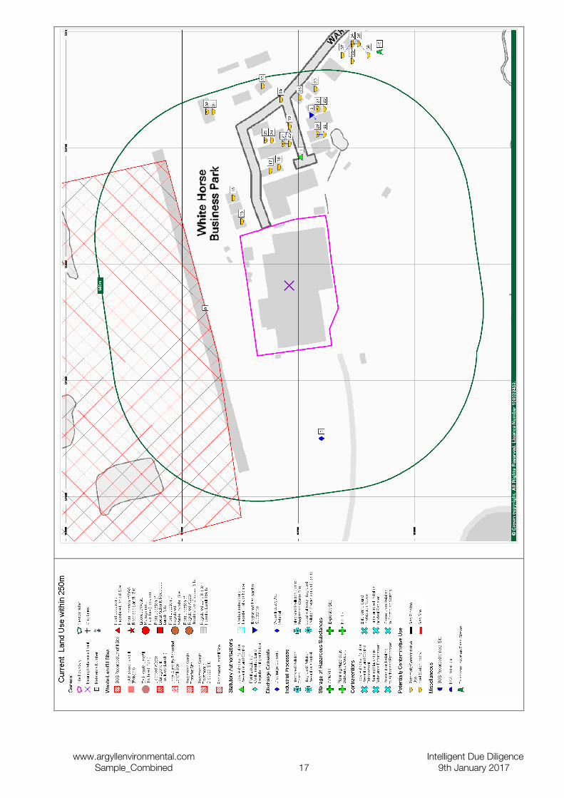
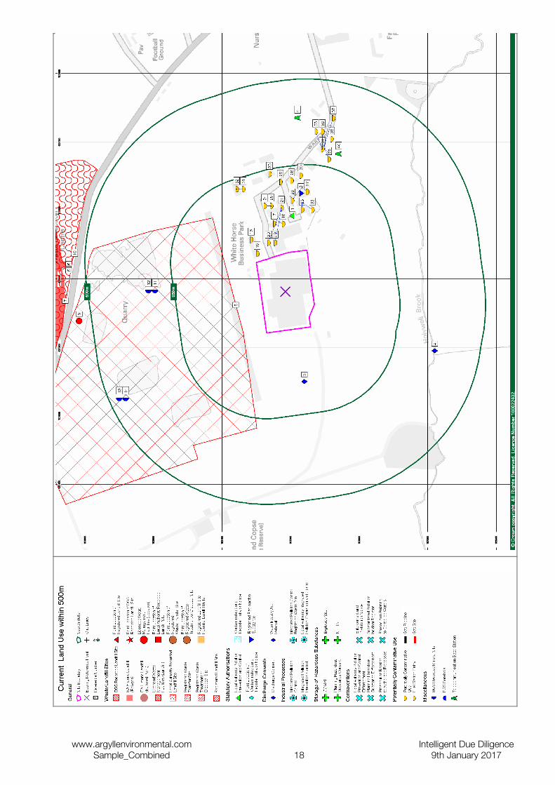
Current Land Use Mapping
This section provides information on current land uses and is divided into three sections, statutory information, waste and current industrial uses. It is preceded by two maps.
Statutory Information
This section presents detailed statutory information for the Site and surrounding area (up to 500m depending upon dataset). The Map ID of each feature is indicated (where applicable) followed by specific information on each feature and its distance and direction from the Site.
If no data is identified then the section will be omitted.
Waste This section presents detailed information on waste and landfill sites for the Site and surrounding area (up to 500m depending upon dataset). The Map ID of each feature is indicated (where applicable) followed by specific information on each feature and its distance and direction from the Site.
If no data is identified then the section will be omitted.
Current Industrial Land Use
This section presents detailed information on current land use for the Site and surrounding area (0-250m). The Map ID of each feature is indicated (where applicable) followed by specific information on each feature and its distance and direction from the Site.
If no data is identified then the section will be omitted.
Historical Land Use Mapping
The Historical Land Use Map presents 1:10,000 scale and selected 1:2,500 scale (tanks and energy facilities) historical land use information within 250m of the Site boundary.
Historical Land Use This section presents selected information on historical land use for the Site and surrounding area (0-250m). The Map ID of each feature is indicated (where applicable) followed by specific information on each feature and its distance and direction from the Site.
If no data is identified then the section will be omitted.Aquifer Designations and Geology
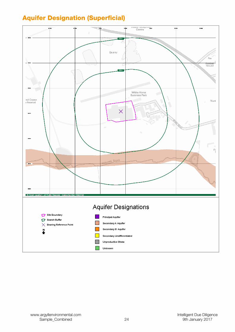
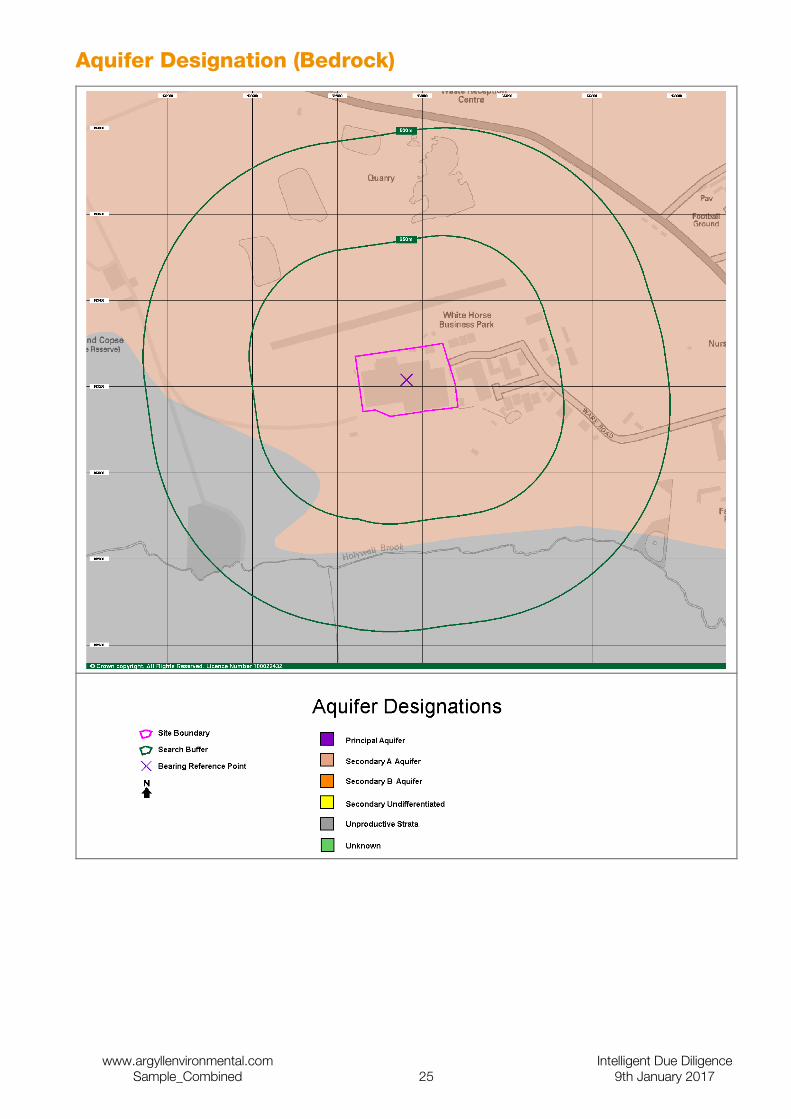
This section is preceded by two maps that present information relating to the aquifer designations beneath the Site. The first of these maps indicates the designation of the Superficial geology. The second map presents the aquifer designation of the solid geology.
These maps are followed by detailed information in relation to aquifer designations/groundwater vulnerability and geology at the Site and surrounding area (0-500m).
If no data is identified then the section will be omitted.
Environmental Sensitivity
This section presents detailed information on the environmental sensitivity of the Site and surrounding area (up to 500m depending upon dataset) and is preceded by two maps. The first shows areas with statutory designations, the second shows source protection zones. The Map ID of each feature is indicated (where applicable) followed by specific information on each feature and its distance and direction from the Site.
If no data is identified then the section will be omitted.
Natural and Mining Related Hazards
This section contains information on natural and mining related hazards which may affect the Site. These include subsidence, radon and mining.
Flooding This section contains information on the risks associated with flooding. It includes maps and data associated with Flooding from Rivers or Sea, The Environment Agency Risk of Flooding from Rivers and Sea, Groundwater Flooding, Surface Water Flooding, Historical Flooding and other information such as the Detailed River Network.
© Landmark Information Group Limited 2017. All Rights Reserved. The copyright on the information and data as contained in the Data section of this Report ("Report") is the property of Landmark Information Group Limited ("Landmark") and several other Data Providers, including (but not limited to) Ordnance Survey, British Geological Survey, The Environment Agency and English Nature, and must not be reproduced in whole or in part by photocopying or any other method.
www.argyllenvironmental.com Intelligent Due DiligenceSample_Combined 13 9th January 2017

Tabular Summary
Statutory Information
Authorisations On-site 1-250m 251-500mLocal Authority Pollution Prevention and Controls 0 1 0Local Authority Integrated Pollution Prevention and Controls 0 0 0Integrated Pollution Controls 0 0 0Integrated Pollution Prevention And Control 0 0 0Registered Radioactive Substances 0 1 0
Discharges On-site 1-250m 251-500mDischarge Consents 0 1 1Water Industry Act Referrals 0 0 0
Hazardous Sites On-site 1-250m 251-500mControl of Major Accident Hazards Sites 0 0 0Explosive Sites 0 0 0Notification of Installations Handling Hazardous Substances 0 0 0Planning Hazardous Substance Consents 0 0 0
Contraventions On-site 1-250m 251-500mContaminated Land Register Entries and Notices 0 0 0Local Authority Pollution Prevention and Control Enforcements 0 0 0Enforcement and Prohibition Notices 0 0 0Planning Hazardous Substance Enforcements 0 0 0Substantiated Pollution Incident Register 0 0 0Prosecutions Relating to Authorised Processes 0 0 0Prosecutions Relating to Controlled Waters 0 0 0
Waste
Waste/Landfill Sites On-site 1-250m 251-500mBGS Recorded Landfill Sites 0 0 0Integrated Pollution Control Registered Waste Sites 0 0 0Licenced Waste Management Facilities (Landfill Boundaries) 0 1 0Licenced Waste Management Facilities (Locations) 0 0 0Local Authority Recorded Landfill Sites 0 0 0 (1) * Registered Landfill Sites 0 0 0 (0) * Registered Waste Transfer Sites 0 0 0Registered Waste Treatment or Disposal Sites 0 0 0Historical Landfill Sites 0 0 0
Current Land Use
Current Potentially Contaminative Uses On-site 1-250m 251-500mContemporary Trade Directory Entries 0 19 6Fuel Station Entries 0 0 0
Other Features On-site 1-250m 251-500mTelecommunication Base Stations 0 02 N/AOverhead Transmission Lines 0 0 0Gas Pipelines 0 0 0Gas Feeders 0 0 0
Historical Land Use
Historical Potentially Contaminative Uses On-site 1-250m 251-500mHistorical Tanks And Energy Facilities 0 0 0
Potentially Infilled Land On-site 1-250m 251-500mFormer Marshes 0 0 0Potentially Infilled Land (Non-Water) 0 0 0Potentially Infilled Land (Water) 0 0 0
2Telecommunication base stations are searched to a radius of 100m from the Site boundary
www.argyllenvironmental.com Intelligent Due DiligenceSample_Combined 14 9th January 2017
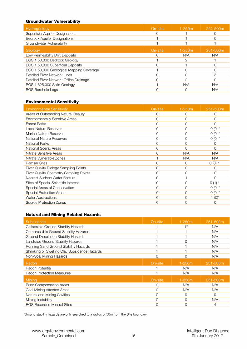
Groundwater Vulnerability
Hydrogeology On-site 1-250m 251-500mSuperficial Aquifer Designations 0 1 0Bedrock Aquifer Designations 1 1 0Groundwater Vulnerability 1 1 1
Geology On-site 1-250m 251-500mLow Permeability Drift Deposits 0 N/A N/ABGS 1:50,000 Bedrock Geology 1 2 1BGS 1:50,000 Superficial Deposits 0 1 0BGS 1:50,000 Geological Mapping Coverage 1 0 0Detailed River Network Lines 0 0 3Detailed River Network Offline Drainage 0 2 0BGS 1:625,000 Solid Geology 1 N/A N/ABGS Borehole Logs 0 0 N/A
Environmental Sensitivity
Environmental Sensitivity On-site 1-250m 251-500mAreas of Outstanding Natural Beauty 0 0 0Environmentally Sensitive Areas 0 0 0Forest Parks 0 0 0Local Nature Reserves 0 0 0 (0) *Marine Nature Reserves 0 0 0 (0) *National Nature Reserves 0 0 0 (0) *National Parks 0 0 0National Scenic Areas 0 0 0Nitrate Sensitive Areas 0 N/A N/ANitrate Vulnerable Zones 1 N/A N/ARamsar Sites 0 0 0 (0) * River Quality Biology Sampling Points 0 0 0River Quality Chemistry Sampling Points 0 0 0Nearest Surface Water Feature 0 1 0Sites of Special Scientific Interest 0 0 0 (1) * Special Areas of Conservation 0 0 0 (0) *Special Protection Areas 0 0 0 (0) *Water Abstractions 0 0 1 (0)*Source Protection Zones 0 0 0
Natural and Mining Related Hazards
Subsidence On-site 1-250m 251-500mCollapsible Ground Stability Hazards 1 13 N/ACompressible Ground Stability Hazards 1 1 N/AGround Dissolution Stability Hazards 1 1 N/ALandslide Ground Stability Hazards 1 0 N/ARunning Sand Ground Stability Hazards 1 1 N/AShrinking or Swelling Clay Subsidence Hazards 1 1 N/ANon-Coal Mining Hazards 0 0 N/A
Radon On-site 1-250m 251-500mRadon Potential 1 N/A N/ARadon Protection Measures 1 N/A N/A
Mining On-site 1-250m 251-500mBrine Compensation Areas 0 N/A N/ACoal Mining Affected Areas 0 N/A N/ANatural and Mining Cavities 0 0 0Mining Instability 0 0 N/ABGS Recorded Mineral Sites 0 0 4
3Ground stability hazards are only searched to a radius of 50m from the Site boundary.
www.argyllenvironmental.com Intelligent Due DiligenceSample_Combined 15 9th January 2017
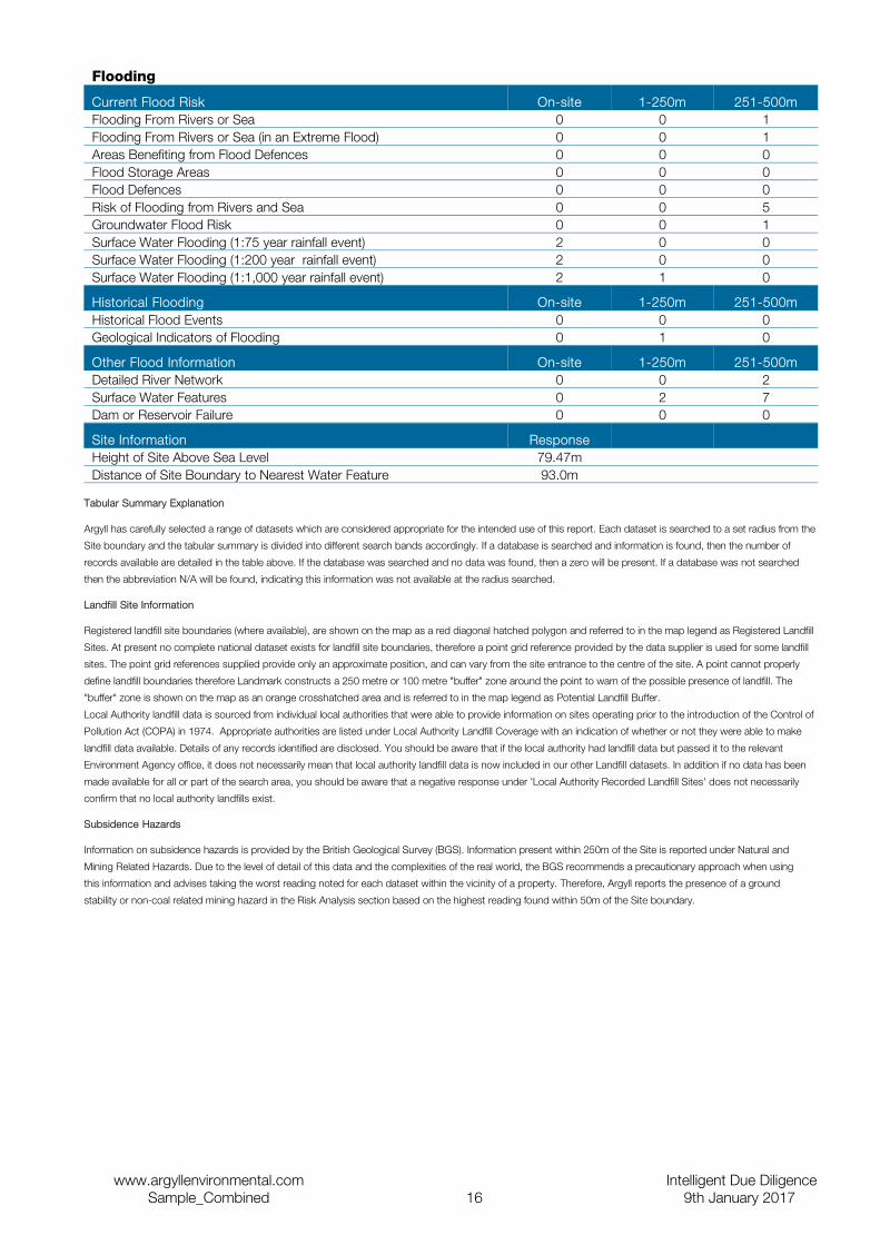
Flooding
Current Flood Risk On-site 1-250m 251-500mFlooding From Rivers or Sea 0 0 1Flooding From Rivers or Sea (in an Extreme Flood) 0 0 1Areas Benefiting from Flood Defences 0 0 0Flood Storage Areas 0 0 0Flood Defences 0 0 0Risk of Flooding from Rivers and Sea 0 0 5Groundwater Flood Risk 0 0 1Surface Water Flooding (1:75 year rainfall event) 2 0 0Surface Water Flooding (1:200 year rainfall event) 2 0 0Surface Water Flooding (1:1,000 year rainfall event) 2 1 0
Historical Flooding On-site 1-250m 251-500mHistorical Flood Events 0 0 0Geological Indicators of Flooding 0 1 0
Other Flood Information On-site 1-250m 251-500mDetailed River Network 0 0 2Surface Water Features 0 2 7Dam or Reservoir Failure 0 0 0
Site Information ResponseHeight of Site Above Sea Level 79.47mDistance of Site Boundary to Nearest Water Feature 93.0m
Tabular Summary Explanation
Argyll has carefully selected a range of datasets which are considered appropriate for the intended use of this report. Each dataset is searched to a set radius from the
Site boundary and the tabular summary is divided into different search bands accordingly. If a database is searched and information is found, then the number of
records available are detailed in the table above. If the database was searched and no data was found, then a zero will be present. If a database was not searched
then the abbreviation N/A will be found, indicating this information was not available at the radius searched.
Landfill Site Information
Registered landfill site boundaries (where available), are shown on the map as a red diagonal hatched polygon and referred to in the map legend as Registered Landfill
Sites. At present no complete national dataset exists for landfill site boundaries, therefore a point grid reference provided by the data supplier is used for some landfill
sites. The point grid references supplied provide only an approximate position, and can vary from the site entrance to the centre of the site. A point cannot properly
define landfill boundaries therefore Landmark constructs a 250 metre or 100 metre "buffer" zone around the point to warn of the possible presence of landfill. The
"buffer" zone is shown on the map as an orange crosshatched area and is referred to in the map legend as Potential Landfill Buffer.
Local Authority landfill data is sourced from individual local authorities that were able to provide information on sites operating prior to the introduction of the Control of
Pollution Act (COPA) in 1974. Appropriate authorities are listed under Local Authority Landfill Coverage with an indication of whether or not they were able to make
landfill data available. Details of any records identified are disclosed. You should be aware that if the local authority had landfill data but passed it to the relevant
Environment Agency office, it does not necessarily mean that local authority landfill data is now included in our other Landfill datasets. In addition if no data has been
made available for all or part of the search area, you should be aware that a negative response under 'Local Authority Recorded Landfill Sites' does not necessarily
confirm that no local authority landfills exist.
Subsidence Hazards
Information on subsidence hazards is provided by the British Geological Survey (BGS). Information present within 250m of the Site is reported under Natural and
Mining Related Hazards. Due to the level of detail of this data and the complexities of the real world, the BGS recommends a precautionary approach when using
this information and advises taking the worst reading noted for each dataset within the vicinity of a property. Therefore, Argyll reports the presence of a ground
stability or non-coal related mining hazard in the Risk Analysis section based on the highest reading found within 50m of the Site boundary.
www.argyllenvironmental.com Intelligent Due DiligenceSample_Combined 16 9th January 2017
www.argyllenvironmental.com Intelligent Due DiligenceSample_Combined 17 9th January 2017
www.argyllenvironmental.com Intelligent Due DiligenceSample_Combined 18 9th January 2017
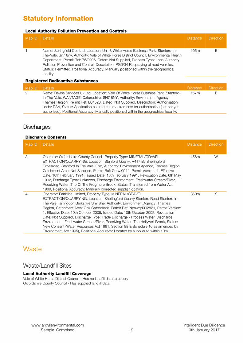
Statutory Information
Local Authority Pollution Prevention and Controls
Map ID Details Distance Direction
1 Name: Springfield Cps Ltd, Location: Unit 8 White Horse Business Park, Stanford-In-The-Vale, Sn7 8ny, Authority: Vale of White Horse District Council, Environmental Health Department, Permit Ref: 76/2006, Dated: Not Supplied, Process Type: Local Authority Pollution Prevention and Control, Description: PG6/34 Respraying of road vehicles, Status: Permitted, Positional Accuracy: Manually positioned within the geographical locality.
105m E
Registered Radioactive Substances
Map ID Details Distance Direction2 Name: Reviss Services Uk Ltd, Location: Vale Of White Horse Business Park, Stanford-
In-The-Vale, WANTAGE, Oxfordshire, SN7 8NY, Authority: Environment Agency, Thames Region, Permit Ref: BJ4523, Dated: Not Supplied, Description: Authorisation under RSA, Status: Application has met the requirements for authorisation (but not yet authorised), Positional Accuracy: Manually positioned within the geographical locality.
167m E
Discharges
Discharge Consents
Map ID Details Distance Direction
3 Operator: Oxfordshire County Council, Property Type: MINERAL/GRAVEL EXTRACTION/QUARRYING, Location: Stanford Quarry, A417 By Shellingford Crossroad, Stanford In The Vale, Oxo, Authority: Environment Agency, Thames Region, Catchment Area: Not Supplied, Permit Ref: Cntw.0944, Permit Version: 1, Effective Date: 18th February 1991, Issued Date: 18th February 1991, Revocation Date: 6th May 1992, Discharge Type: Unknown, Discharge Environment: Freshwater Stream/River, Receiving Water: Trib Of The Frogmore Brook, Status: Transferred from Water Act 1989, Positional Accuracy: Manually corrected supplier location.
156m W
4 Operator: Earthline Limited, Property Type: MINERAL/GRAVEL EXTRACTION/QUARRYING, Location: Shellingford Quarry Stanford Road Stanford In The Vale Farringdon Berkshire Sn7 8he, Authority: Environment Agency, Thames Region, Catchment Area: Ock Catchment, Permit Ref: Npswqd002821, Permit Version: 1, Effective Date: 10th October 2008, Issued Date: 10th October 2008, Revocation Date: Not Supplied, Discharge Type: Trade Discharge - Process Water, Discharge Environment: Freshwater Stream/River, Receiving Water: The Hollywell Brook, Status: New Consent (Water Resources Act 1991, Section 88 & Schedule 10 as amended by Environment Act 1995), Positional Accuracy: Located by supplier to within 10m.
369m S
Waste
Waste/Landfill SitesLocal Authority Landfill CoverageVale of White Horse District Council - Has no landfill data to supplyOxfordshire County Council - Has supplied landfill data
www.argyllenvironmental.com Intelligent Due DiligenceSample_Combined 19 9th January 2017
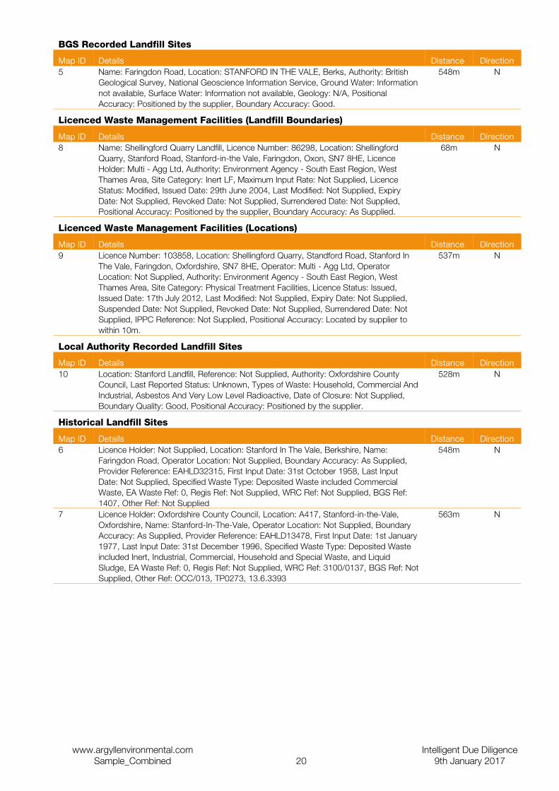
BGS Recorded Landfill Sites
Map ID Details Distance Direction5 Name: Faringdon Road, Location: STANFORD IN THE VALE, Berks, Authority: British
Geological Survey, National Geoscience Information Service, Ground Water: Information not available, Surface Water: Information not available, Geology: N/A, Positional Accuracy: Positioned by the supplier, Boundary Accuracy: Good.
548m N
Licenced Waste Management Facilities (Landfill Boundaries)
Map ID Details Distance Direction8 Name: Shellingford Quarry Landfill, Licence Number: 86298, Location: Shellingford
Quarry, Stanford Road, Stanford-in-the Vale, Faringdon, Oxon, SN7 8HE, Licence Holder: Multi - Agg Ltd, Authority: Environment Agency - South East Region, West Thames Area, Site Category: Inert LF, Maximum Input Rate: Not Supplied, Licence Status: Modified, Issued Date: 29th June 2004, Last Modified: Not Supplied, Expiry Date: Not Supplied, Revoked Date: Not Supplied, Surrendered Date: Not Supplied, Positional Accuracy: Positioned by the supplier, Boundary Accuracy: As Supplied.
68m N
Licenced Waste Management Facilities (Locations)
Map ID Details Distance Direction9 Licence Number: 103858, Location: Shellingford Quarry, Standford Road, Stanford In
The Vale, Faringdon, Oxfordshire, SN7 8HE, Operator: Multi - Agg Ltd, Operator Location: Not Supplied, Authority: Environment Agency - South East Region, West Thames Area, Site Category: Physical Treatment Facilities, Licence Status: Issued, Issued Date: 17th July 2012, Last Modified: Not Supplied, Expiry Date: Not Supplied, Suspended Date: Not Supplied, Revoked Date: Not Supplied, Surrendered Date: Not Supplied, IPPC Reference: Not Supplied, Positional Accuracy: Located by supplier to within 10m.
537m N
Local Authority Recorded Landfill Sites
Map ID Details Distance Direction10 Location: Stanford Landfill, Reference: Not Supplied, Authority: Oxfordshire County
Council, Last Reported Status: Unknown, Types of Waste: Household, Commercial And Industrial, Asbestos And Very Low Level Radioactive, Date of Closure: Not Supplied, Boundary Quality: Good, Positional Accuracy: Positioned by the supplier.
528m N
Historical Landfill Sites
Map ID Details Distance Direction6 Licence Holder: Not Supplied, Location: Stanford In The Vale, Berkshire, Name:
Faringdon Road, Operator Location: Not Supplied, Boundary Accuracy: As Supplied, Provider Reference: EAHLD32315, First Input Date: 31st October 1958, Last Input Date: Not Supplied, Specified Waste Type: Deposited Waste included Commercial Waste, EA Waste Ref: 0, Regis Ref: Not Supplied, WRC Ref: Not Supplied, BGS Ref: 1407, Other Ref: Not Supplied
548m N
7 Licence Holder: Oxfordshire County Council, Location: A417, Stanford-in-the-Vale, Oxfordshire, Name: Stanford-In-The-Vale, Operator Location: Not Supplied, Boundary Accuracy: As Supplied, Provider Reference: EAHLD13478, First Input Date: 1st January 1977, Last Input Date: 31st December 1996, Specified Waste Type: Deposited Waste included Inert, Industrial, Commercial, Household and Special Waste, and Liquid Sludge, EA Waste Ref: 0, Regis Ref: Not Supplied, WRC Ref: 3100/0137, BGS Ref: Not Supplied, Other Ref: OCC/013, TP0273, 13.6.3393
563m N
www.argyllenvironmental.com Intelligent Due DiligenceSample_Combined 20 9th January 2017
Current Land Use
Current Potentially Contaminative Uses
Contemporary Trade Directory Entries
Map ID Details Distance Direction15 Sheet Metal Work, Name: Pritchard Sheet Metal, Status: Active, Location: Unit 15,
White Horse Business Park, Ware Road, Stanford in the Vale, Faringdon, Oxfordshire, SN7 8NY, Positional Accuracy: Automatically positioned to the address.
24m NE
16 Refrigeration Equipment - Commercial, Name: Vale Refrigeration Services, Status: Active, Location: Unit 17, White Horse Business Park, Ware Road, Stanford in the Vale, Faringdon, SN7 8NY, Positional Accuracy: Automatically positioned to the address.
67m NE
17 Aluminium Fabricators, Name: Aluminium Manufacturing Ltd, Status: Active, Location: Unit 14c, White Horse Business Park, Ware Road, Stanford in the Vale, Faringdon, SN7 8NY, Positional Accuracy: Automatically positioned to the address.
93m E
18 Chemical Manufacturers, Name: N A P Ltd, Status: Active, Location: Unit 14a, White Horse Business Park, Ware Road, Stanford in the Vale, Faringdon, Oxfordshire, SN7 8NY, Positional Accuracy: Automatically positioned to the address.
94m E
19 Plastics - Injection Moulding, Name: Injection Moulding Tools, Status: Active, Location: Unit 11, White Horse Business Park, Ware Road, Stanford in the Vale, Faringdon, Oxfordshire, SN7 8NY, Positional Accuracy: Automatically positioned to the address.
132m E
20 Crane Hire, Sales & Service, Name: Biwater Treatment Ltd, Status: Inactive, Location: The Compound, 1, White Horse Business Park, Ware Road, Stanford in the Vale, Faringdon, Oxfordshire, SN7 8NY, Positional Accuracy: Automatically positioned to the address.
132m E
21 Distilleries, Name: Independent Distillers, Status: Inactive, Location: White Horse Business Park, Ware Road, Stanford in the Vale, Faringdon, Oxfordshire, SN7 8NY, Positional Accuracy: Automatically positioned to the address.
132m E
22 Refrigeration Equipment - Commercial, Name: Ecoquip Ltd, Status: Inactive, Location: White Horse Business Park, Ware Road, Stanford in the Vale, Faringdon, Oxfordshire, SN7 8NY, Positional Accuracy: Manually positioned to the address or location.
140m E
23 Plastics - Injection Moulding, Name: White Horse Plastics, Status: Active, Location: Unit 6, White Horse Business Park, Ware Road, Stanford in the Vale, Faringdon, Oxfordshire, SN7 8NY, Positional Accuracy: Automatically positioned to the address.
141m E
24 Garage Services, Name: Foxtail Garage, Status: Active, Location: White Horse Business Park, Ware Road, Stanford in the Vale, Faringdon, SN7 8NY, Positional Accuracy: Automatically positioned to the address.
145m E
25 Commercial Vehicle Bodybuilders & Repairers, Name: Springfield Cps, Status: Inactive, Location: White Horse Business Pk, Ware Rd, Stanford in the Vale, Faringdon, Oxfordshire, SN7 8NY, Positional Accuracy: Automatically positioned to the address.
145m E
26 Control Panel Manufacturers, Name: Viking Engineering & Automation, Status: Inactive, Location: White Horse Business Park, Ware Road, Stanford in the Vale, Faringdon, Oxfordshire, SN7 8NY, Positional Accuracy: Automatically positioned to the address.
184m E
27 Road Haulage Services, Name: J Godfrey & Son, Status: Inactive, Location: White Horse Business Park, Ware Road, Stanford in the Vale, Faringdon, Oxfordshire, SN7 8NY, Positional Accuracy: Automatically positioned to the address.
184m E
28 Brewers, Name: White Horse Brewery, Status: Active, Location: Unit 3, White Horse Business Park, Ware Road, Stanford in the Vale, Faringdon, Oxfordshire, SN7 8NY, Positional Accuracy: Automatically positioned to the address.
207m E
29 Lighting Manufacturers, Name: Steen Powered Services Ltd, Status: Inactive, Location: Unit 1b, White Horse Business Pk, Ware Rd, Stanford In The Vale, Faringdon, Oxfordshire, SN7 8NY, Positional Accuracy: Manually positioned within the geographical locality.
208m E
30 Car Manufacturers, Name: The Light Car Co Ltd, Status: Inactive, Location: Unit 1, White Horse Business Park, Faringdon Road, Stanford in the Vale, Faringdon, Oxfordshire, SN7 8NN, Positional Accuracy: Automatically positioned to the address.
219m E
31 Pumps - Sales, Servicing & Repairs, Name: Cobra Concrete Pumps, Status: Active, Location: White Horse Business Park, Ware Road, Stanford in the Vale, FARINGDON, Oxfordshire, SN7 8NY, Positional Accuracy: Automatically positioned to the address.
222m NE
www.argyllenvironmental.com Intelligent Due DiligenceSample_Combined 21 9th January 2017
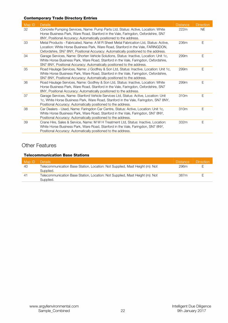
Contemporary Trade Directory Entries
Map ID Details Distance Direction32 Concrete Pumping Services, Name: Pump Parts Ltd, Status: Active, Location: White
Horse Business Park, Ware Road, Stanford in the Vale, Faringdon, Oxfordshire, SN7 8NY, Positional Accuracy: Automatically positioned to the address.
222m NE
33 Metal Products - Fabricated, Name: A M R Sheet Metal Fabrication Ltd, Status: Active, Location: White Horse Business Park, Ware Road, Stanford in the Vale, FARINGDON, Oxfordshire, SN7 8NY, Positional Accuracy: Automatically positioned to the address.
236m E
34 Garage Services, Name: Shorten Vehicle Solutions, Status: Inactive, Location: Unit 1c, White Horse Business Park, Ware Road, Stanford in the Vale, Faringdon, Oxfordshire, SN7 8NY, Positional Accuracy: Automatically positioned to the address.
299m E
35 Road Haulage Services, Name: J Godfrey & Son Ltd, Status: Inactive, Location: Unit 1c, White Horse Business Park, Ware Road, Stanford in the Vale, Faringdon, Oxfordshire, SN7 8NY, Positional Accuracy: Automatically positioned to the address.
299m E
36 Road Haulage Services, Name: Godfrey & Son Ltd, Status: Inactive, Location: White Horse Business Park, Ware Road, Stanford in the Vale, Faringdon, Oxfordshire, SN7 8NY, Positional Accuracy: Automatically positioned to the address.
299m E
37 Garage Services, Name: Stanford Vehicle Services Ltd, Status: Active, Location: Unit 1c, White Horse Business Park, Ware Road, Stanford in the Vale, Faringdon, SN7 8NY, Positional Accuracy: Automatically positioned to the address.
310m E
38 Car Dealers - Used, Name: Faringdon Car Centre, Status: Active, Location: Unit 1c, White Horse Business Park, Ware Road, Stanford in the Vale, Faringdon, SN7 8NY, Positional Accuracy: Automatically positioned to the address.
310m E
39 Crane Hire, Sales & Service, Name: M W H Treatment Ltd, Status: Inactive, Location: White Horse Business Park, Ware Road, Stanford in the Vale, Faringdon, SN7 8NY, Positional Accuracy: Automatically positioned to the address.
332m E
Other Features
Telecommunication Base Stations
Map ID Details Distance Direction40 Telecommunication Base Station, Location: Not Supplied, Mast Height (m): Not
Supplied.296m E
41 Telecommunication Base Station, Location: Not Supplied, Mast Height (m): Not Supplied.
387m E
www.argyllenvironmental.com Intelligent Due DiligenceSample_Combined 22 9th January 2017
Historical Land Use
Historical Potentially Contaminative Uses
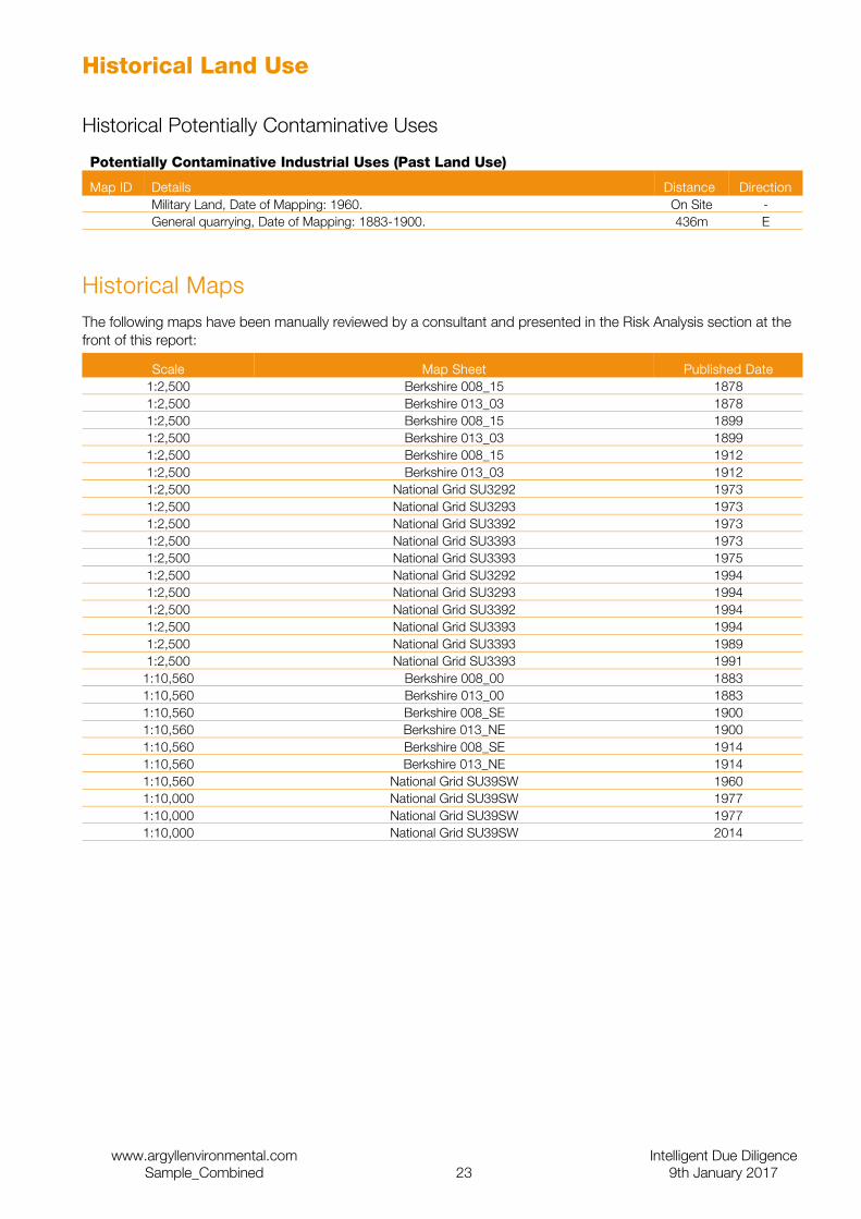
Potentially Contaminative Industrial Uses (Past Land Use)
Map ID Details Distance DirectionMilitary Land, Date of Mapping: 1960. On Site -General quarrying, Date of Mapping: 1883-1900. 436m E
Historical MapsThe following maps have been manually reviewed by a consultant and presented in the Risk Analysis section at the front of this report:
Scale Map Sheet Published Date1:2,500 Berkshire 008_15 18781:2,500 Berkshire 013_03 18781:2,500 Berkshire 008_15 18991:2,500 Berkshire 013_03 18991:2,500 Berkshire 008_15 19121:2,500 Berkshire 013_03 19121:2,500 National Grid SU3292 19731:2,500 National Grid SU3293 19731:2,500 National Grid SU3392 19731:2,500 National Grid SU3393 19731:2,500 National Grid SU3393 19751:2,500 National Grid SU3292 19941:2,500 National Grid SU3293 19941:2,500 National Grid SU3392 19941:2,500 National Grid SU3393 19941:2,500 National Grid SU3393 19891:2,500 National Grid SU3393 19911:10,560 Berkshire 008_00 18831:10,560 Berkshire 013_00 18831:10,560 Berkshire 008_SE 19001:10,560 Berkshire 013_NE 19001:10,560 Berkshire 008_SE 19141:10,560 Berkshire 013_NE 19141:10,560 National Grid SU39SW 19601:10,000 National Grid SU39SW 19771:10,000 National Grid SU39SW 19771:10,000 National Grid SU39SW 2014
www.argyllenvironmental.com Intelligent Due DiligenceSample_Combined 23 9th January 2017
Aquifer Designation (Superficial)
www.argyllenvironmental.com Intelligent Due DiligenceSample_Combined 24 9th January 2017
Aquifer Designation (Bedrock)
www.argyllenvironmental.com Intelligent Due DiligenceSample_Combined 25 9th January 2017
Groundwater Vulnerability
Hydrogeology
Superficial Aquifer Designations
Map ID Details Distance DirectionSecondary Aquifer - A
These aquifers are formed of moderately permeable layers capable of supporting water supplies at a local scale, and in some cases forming an important source of base flow to rivers.
241m S
Bedrock Aquifer Designations
Map ID Details Distance DirectionSecondary Aquifer - A
These aquifers are formed of moderately permeable layers capable of supporting water supplies at a local scale, and in some cases forming an important source of base flow to rivers.
On Site -
Unproductive Strata
The rock layers or drift deposits have a low permeability that have negligible significance for water supply or river base flow.
180m SW
Groundwater Vulnerability
Map ID Details Distance DirectionSoil Classification: Soils of High Leaching Potential (H1) - Soils which readily transmit liquid discharges because they are either shallow, or susceptible to rapid by-pass flow directly to rock, gravel or groundwater, Map Scale: 1:100,000, Map Name: Sheet 38 Upper Thames & Bedfordshire.
On Site -
Soil Classification: Not classified, Map Scale: 1:100,000, Map Name: Sheet 38 Upper Thames & Bedfordshire.
159m SW
Soil Classification: Not classified, Map Scale: 1:100,000, Map Name: Sheet 38 Upper Thames & Bedfordshire.
383m S
GeologyBGS 1:50,000 Bedrock Geology
Map ID Details Distance DirectionLEX Code: STFD, Rock Name: Stanford Formation, Rock Type: Limestone, Min Age: Oxfordian, Max Age: Oxfordian.
On Site -
LEX Code: KTON, Rock Name: Kingston Formation, Rock Type: Sandstone, Min Age: Oxfordian, Max Age: Oxfordian.
107m N
LEX Code: AMKC, Rock Name: Ampthill Clay Formation and Kimmeridge Clay Formation (Undifferentiated), Rock Type: Mudstone, Min Age: Kimmeridgian, Max Age: Oxfordian.
180m SW
LEX Code: KTON, Rock Name: Kingston Formation, Rock Type: Sandstone, Min Age: Oxfordian, Max Age: Oxfordian.
459m E
BGS 1:50,000 Superficial Deposits
Map ID Details Distance DirectionLEX Code: ALV, Rock Name: Alluvium, Rock Type: Clay, Silt, Sand and Gravel, Min Age: Flandrian, Max Age: Flandrian.
241m S
BGS 1:50,000 Geological Mapping Coverage
Map ID Details Distance DirectionMap Sheet No: 253, Map Name: Abingdon, Map Date: 1971, Bedrock Geology: Available, Superficial Geology: Available, Artificial Geology: Available, Faults: Not Supplied, Landslip: Available, Rock Segments: Not Supplied.
On Site -
www.argyllenvironmental.com Intelligent Due DiligenceSample_Combined 26 9th January 2017
Detailed River Network Lines
Map ID Details Distance DirectionSecondary River, River Name: Holywell Brook
Hydrographic Area: B06, River Flow Type: Primary Flow Path, River Surface Level: Surface, Drain Feature: Not a Drain, Flood Risk Management Status: Other Rivers, Water Course Name: Not Supplied, Water Course Reference: Not Supplied.
318m S
Secondary River, River Name: Holywell Brook
Hydrographic Area: B06, River Flow Type: Primary Flow Path, River Surface Level: Surface, Drain Feature: Not a Drain, Flood Risk Management Status: Other Rivers, Water Course Name: Not Supplied, Water Course Reference: Not Supplied.
365m SW
Tertiary River, River Name: Drain
Hydrographic Area: B06, River Flow Type: Secondary Flow Path, River Surface Level: Surface, Drain Feature: Drain (ditch, Reen, Rhyne, Drain), Flood Risk Management Status: Other Rivers, Water Course Name: Not Supplied, Water Course Reference: Not Supplied.
369m SW
Detailed River Network Offline Drainage
Map ID Details Distance DirectionRiver Type: Tertiary River 6m SERiver Type: Tertiary River 59m E
BGS 1:625,000 Solid Geology
Map ID Details Distance DirectionCorallian Group. On Site -
www.argyllenvironmental.com Intelligent Due DiligenceSample_Combined 27 9th January 2017

Environmentally Sensitive Features
www.argyllenvironmental.com Intelligent Due DiligenceSample_Combined 28 9th January 2017
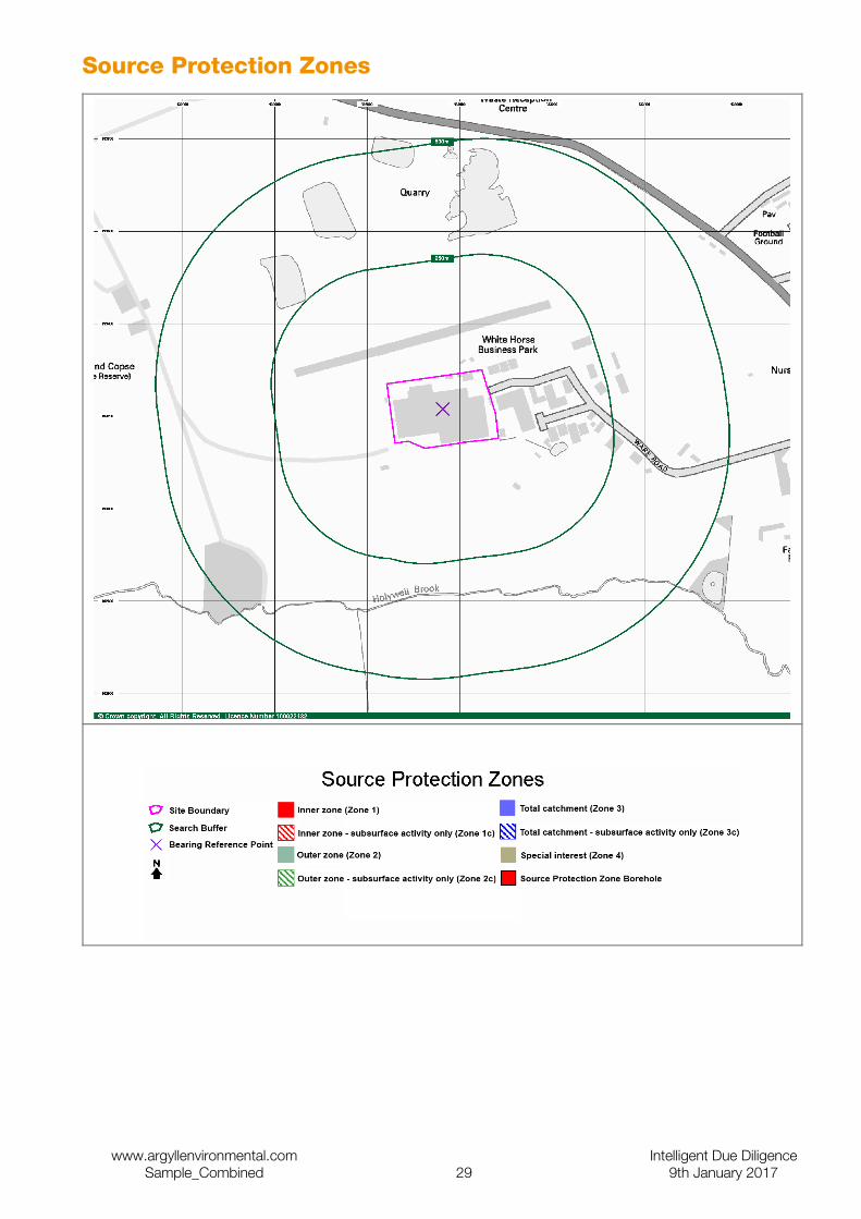
Source Protection Zones
www.argyllenvironmental.com Intelligent Due DiligenceSample_Combined 29 9th January 2017
Environmentally Sensitive Features
Nitrate Vulnerable Zones
Map ID Details Distance Direction1 Name: , Description: Surface Water, Source: Department for Environment, Food and
Rural Affairs (DEFRA - formerly FRCA).On Site -
Nearest Surface Water Feature
Map ID Details Distance Direction2 Surface water feature identified in proximity. 6m SE
Sites of Special Scientific Interest
Map ID Details Distance DirectionName: Shellingford Crossroads Quarry, Multiple Area: N, Area (m2): 26397.52, Source: Natural England, Reference: 1000297, Designation Date: 21st May 1986, Date Type: Notified, Designation Details: Geological Conservation Review.
826m N
Water Abstractions
Map ID Details Distance Direction3 Operator: Multi-Agg Ltd, Licence Number: 28/39/17/0130, Permit Version: Not
Supplied, Location: Shellingford Quarry, SHELLINGFORD, Authority: Environment Agency, Thames Region, Abstraction: Sand And Gravel Washing, Abstraction Type: Not Supplied, Source: Groundwater, Daily Rate(m3): 2182, Yearly Rate (m3): 545530, Corallian; Status: Revoked; Lapsed Or Cancelled, Authorised Start: Not Supplied, Authorised End: Not Supplied, Permit Start Date: Not Supplied, Permit End Date: Not Supplied, Positional Accuracy: Located by supplier to within 100m.
432m N
Natural and Mining Related Hazards
Subsidence
Collapsible Ground Stability Hazards
Map ID Details Distance DirectionRisk: Very Low, Source: British Geological Survey, National Geoscience Information Service.
On Site -
Risk: No Hazard, Source: British Geological Survey, National Geoscience Information Service.
241m S
Compressible Ground Stability Hazards
Map ID Details Distance DirectionRisk: No Hazard, Source: British Geological Survey, National Geoscience Information Service.
On Site -
Risk: Moderate, Source: British Geological Survey, National Geoscience Information Service.
241m S
Ground Dissolution Stability Hazards
Map ID Details Distance DirectionRisk: Very Low, Source: British Geological Survey, National Geoscience Information Service.
On Site -
Risk: Low, Source: British Geological Survey, National Geoscience Information Service. 241m S
Landslide Ground Stability Hazards
Map ID Details Distance DirectionRisk: Very Low, Source: British Geological Survey, National Geoscience Information Service.
On Site -
www.argyllenvironmental.com Intelligent Due DiligenceSample_Combined 30 9th January 2017
Running Sand Ground Stability Hazards
Map ID Details Distance DirectionRisk: No Hazard, Source: British Geological Survey, National Geoscience Information Service.
On Site -
Risk: Low, Source: British Geological Survey, National Geoscience Information Service. 241m S
Shrinking or Swelling Clay Subsidence Hazards
Map ID Details Distance DirectionRisk: No Hazard, Source: British Geological Survey, National Geoscience Information Service.
On Site -
Risk: Moderate, Source: British Geological Survey, National Geoscience Information Service.
180m SW
Radon
Radon Potential
Map ID Details Distance DirectionThe property is in a Lower probability radon area (less than 1% of homes are estimated to be at or above the Action Level)., Source: British Geological Survey, National Geoscience Information Service.
On Site -
Radon Protective Measures
Map ID Details Distance DirectionNone, Source: British Geological Survey, National Geoscience Information Service. On Site -
Mining
BGS Recorded Mineral Sites
Map ID Details Distance Direction11 Site Name: Shellingford Quarry, Site Location: Stanford Road, Stanford In The Vale,
Faringdon, Oxfordshire, Sn7 8ne, Source: British Geological Survey, National Geoscience Information Service, Reference: 226077, Type: Opencast, Status: Dormant, Operator: Not Supplied, Operator Location: Not Supplied, Periodic Type: Jurassic, Geology: Stanford Formation, Commodity: Limestone, Positional Accuracy: Located by supplier to within 10m.
324m N
12 Site Name: Shellingford Quarry, Site Location: Stanford Road, Stanford In The Vale, Faringdon, Oxfordshire, Sn7 8ne, Source: British Geological Survey, National Geoscience Information Service, Reference: 226077, Type: Opencast, Status: Dormant, Operator: Not Supplied, Operator Location: Not Supplied, Periodic Type: Jurassic, Geology: Highworth Grit Member, Commodity: Sand, Positional Accuracy: Located by supplier to within 10m.
324m N
13 Site Name: Shellingford Quarry, Site Location: Stanford Road, Stanford In The Vale, Faringdon, Oxfordshire, Sn7 8ne, Source: British Geological Survey, National Geoscience Information Service, Reference: 3637, Type: Opencast, Status: Active, Operator: Not Supplied, Operator Location: Not Supplied, Periodic Type: Jurassic, Geology: Highworth Grit Member, Commodity: Sand, Positional Accuracy: Located by supplier to within 10m.
471m NW
14 Site Name: Shellingford Quarry, Site Location: Stanford Road, Stanford In The Vale, Faringdon, Oxfordshire, Sn7 8ne, Source: British Geological Survey, National Geoscience Information Service, Reference: 3637, Type: Opencast, Status: Active, Operator: Not Supplied, Operator Location: Not Supplied, Periodic Type: Jurassic, Geology: Stanford Formation, Commodity: Limestone, Positional Accuracy: Located by supplier to within 10m.
471m NW
www.argyllenvironmental.com Intelligent Due DiligenceSample_Combined 31 9th January 2017
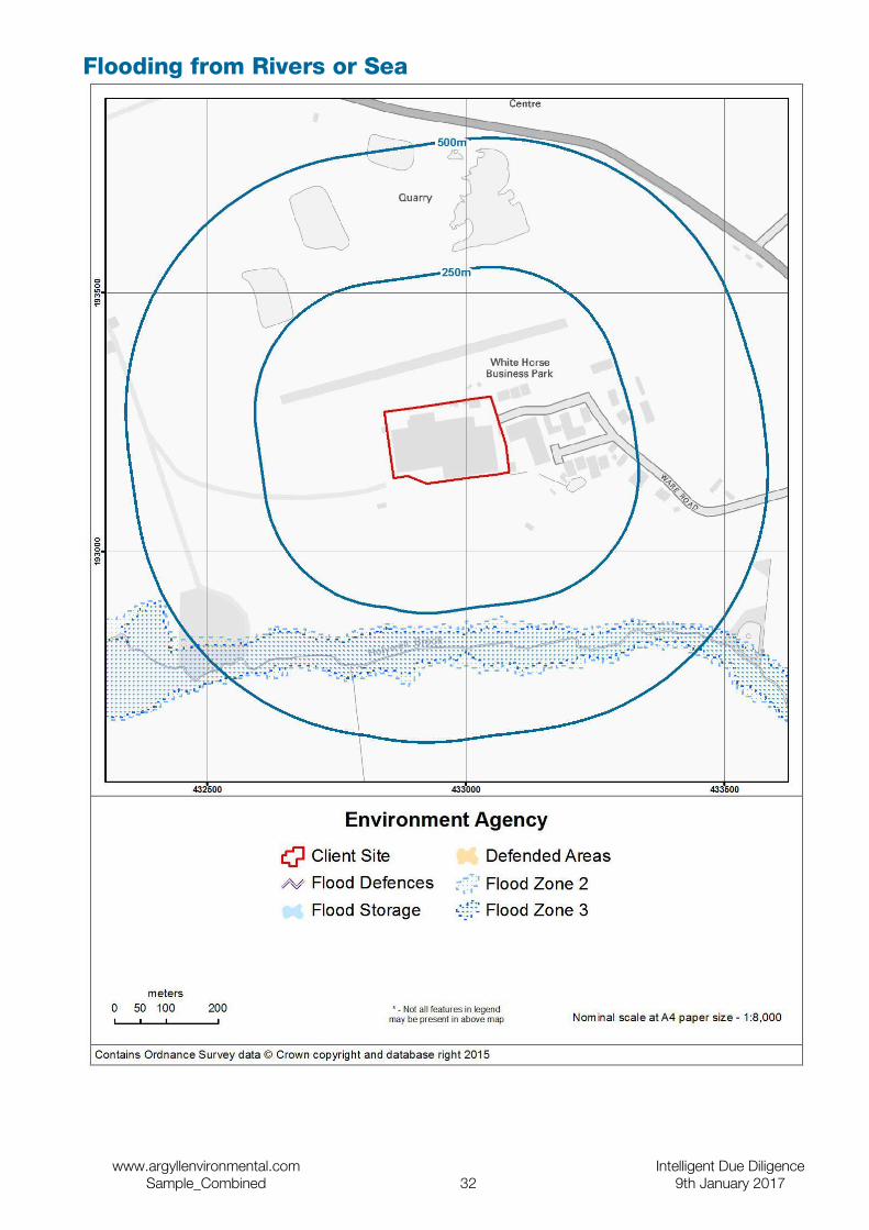
Flooding from Rivers or Sea
www.argyllenvironmental.com Intelligent Due DiligenceSample_Combined 32 9th January 2017
Current Flood Risk
Flooding from River or Sea (Flood Zone 3)
Details Distance Reply or Direction
Are there any flood plains within 500m? <501m YESType: Fluvial Models, Source: The Environment Agency, Boundary Accuracy: As Supplied.
285.7m S
Flooding from River or Sea in an Extreme Flood (Flood Zone 2)
Details Distance Reply or Direction
Are there any flood plains (extreme floods) within 500m? <501m YESType: Fluvial Models, Source: The Environment Agency, Boundary Accuracy: As Supplied.
272.7m S
The Site is at a low risk of flooding from rivers or the sea, as defined by the regulatory body's Flood Map. If the Site area is greater than one hectare, any planning application for development would need to be accompanied by a Flood Risk Assessment in accordance with NPPF.
Flood Defences
Details Distance Reply or Direction
Are there any flood defences within 500m? <501m NO
There are no flood defences within 500m of the Site. There may be a small residual risk of flooding from overtopping or failure of defences more distant from the Site. Reference should be made to the assessment of 'Areas Benefiting from Flood Defences' to ascertain whether the Site could potentially be at risk.
Areas Benefiting from Flood Defences
Details Distance Reply or Direction
Does the Site or any areas within 500m benefit from flood defences? <501m NO
The Site is over 500m from an Area Benefiting from a Flood Defence, as defined by the regulatory body. The residual risk that the Site may flood if the protection standard of any flood defences is exceeded, or if the defences fail, is insignificant.
Flood Storage Areas
Details Distance Reply or Direction
Are there any flood storage areas within 500m? <501m NO
The Site is over 500m from a Flood Storage Area (FSA) as defined by the regulatory body. These areas store flood water during flood events. It is unlikely that any FSA presents any associated flood risk to the Site.
www.argyllenvironmental.com Intelligent Due DiligenceSample_Combined 33 9th January 2017
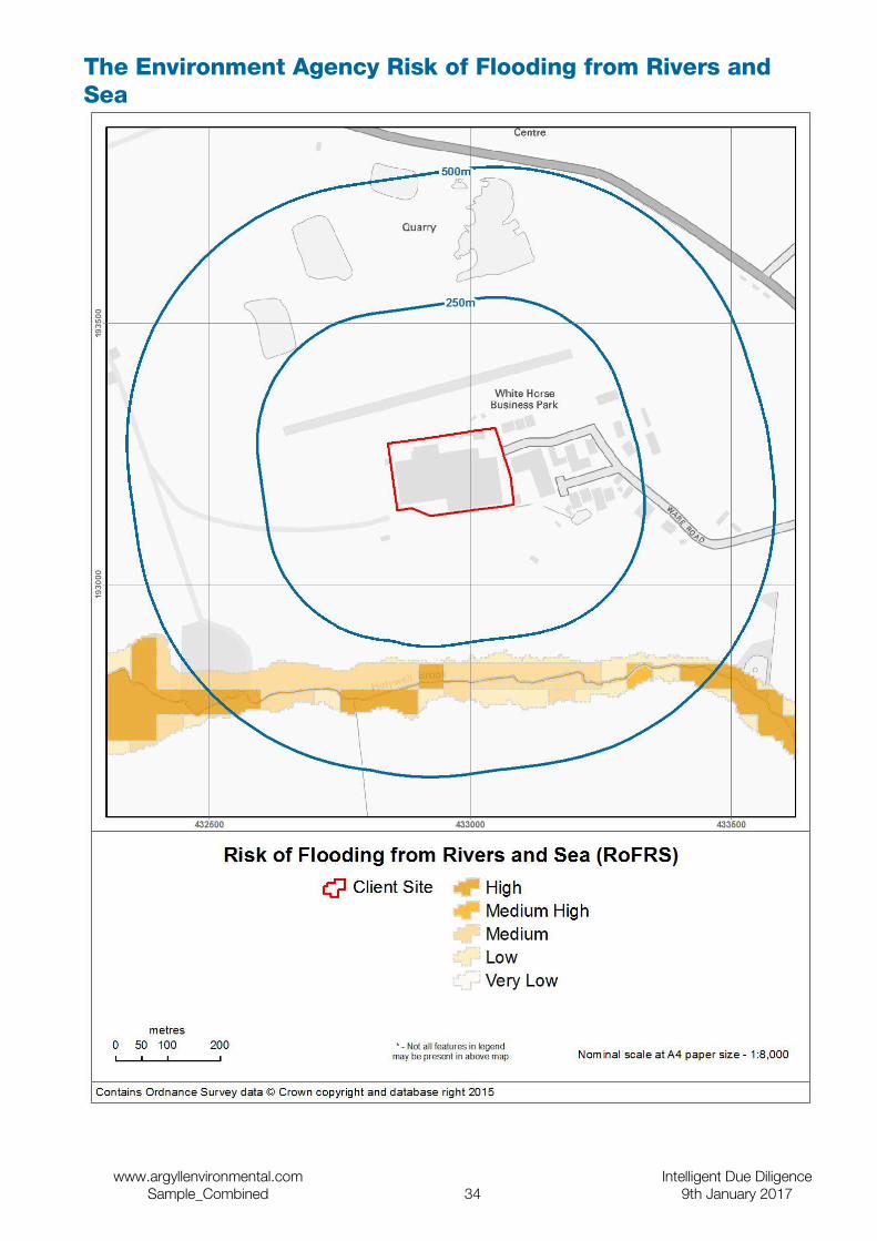
The Environment Agency Risk of Flooding from Rivers and Sea
www.argyllenvironmental.com Intelligent Due DiligenceSample_Combined 34 9th January 2017

Risk of Flooding from Rivers and Sea
Details Distance Reply or Direction
What is the flood likelihood category for the Site? On Site -
Some areas may be classified as having no result. This occurs where there is no output data from the regulatory body's risk assessment, but the area falls within the extreme flood outline (with a 0.1% or 1 in 1000 chance of flooding in any year).
The Environment Agency Data
The data in the Property Flood Likelihood Database is sourced from The Environment Agency’s National Receptor Dataset (NRD). The information provided includes the flood likelihood category low, moderate, or significant according to the flood likelihood analysis. Some areas may be classified as having no result. This occurs where there is no output data from the analysis, but the area falls within the extreme flood outline (with a 0.1% or 1 in 1000 chance of flooding in any year).
www.argyllenvironmental.com Intelligent Due DiligenceSample_Combined 35 9th January 2017
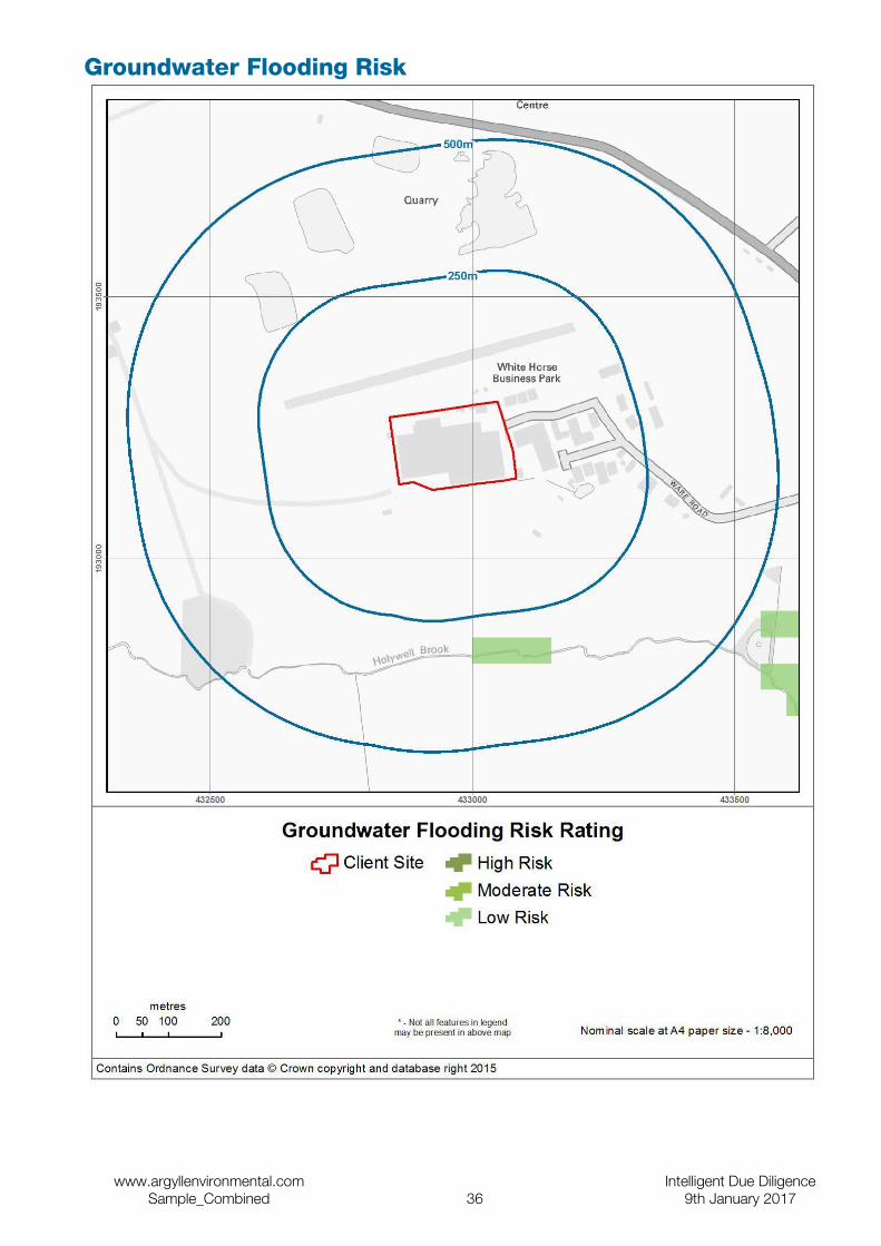
Groundwater Flooding Risk
www.argyllenvironmental.com Intelligent Due DiligenceSample_Combined 36 9th January 2017

Groundwater Flooding Risk
Details Distance Reply or Direction
What is the risk of groundwater flooding at the Site? On Site -
Information from GeoSmart Information Ltd indicates that there is a negligible risk of groundwater flooding in this area and any groundwater flooding incidence will be less frequent than 1 in 100 years return period.No further investigation of risk is deemed necessary unless the proposed site use is unusually sensitive. However, data may be lacking in some areas, so assessment as ‘negligible risk’ on the basis of the map does not rule out local flooding due to features not currently represented in the national datasets used to generate this version of the map.
GeoSmart Information Ltd Data
GeoSmart Information Ltd provides data to Argyll in relation to groundwater flooding. Through research and development, building on their expertise in addressing groundwater flooding issues for The Environment Agency and other clients in the UK, GeoSmart Information Ltd has developed algorithms and calibrated predictions of the risk of groundwater flooding occurring in England and Wales. This differs from other suppliers of data regarding groundwater flooding which only report on the susceptibility of groundwater flooding. Susceptibility merely has to be identified, whereas risk must be quantified. The resulting map is a 50x50m classification of groundwater flooding risk into four categories (Negligible, Low, Moderate and High). GeoSmart Information Ltd’s classifications are based on the level of risk, combining severity and uncertainty that a site will suffer groundwater flooding within a return period of about 100 years.
The map is a general purpose indicative screening tool, and is intended to provide a useful initial view for a wide variety of applications. However, it does not provide an alternative to a site specific assessment, and a detailed risk assessment should be used for any site where the impact of groundwater flooding would have significant adverse consequences.
www.argyllenvironmental.com Intelligent Due DiligenceSample_Combined 37 9th January 2017
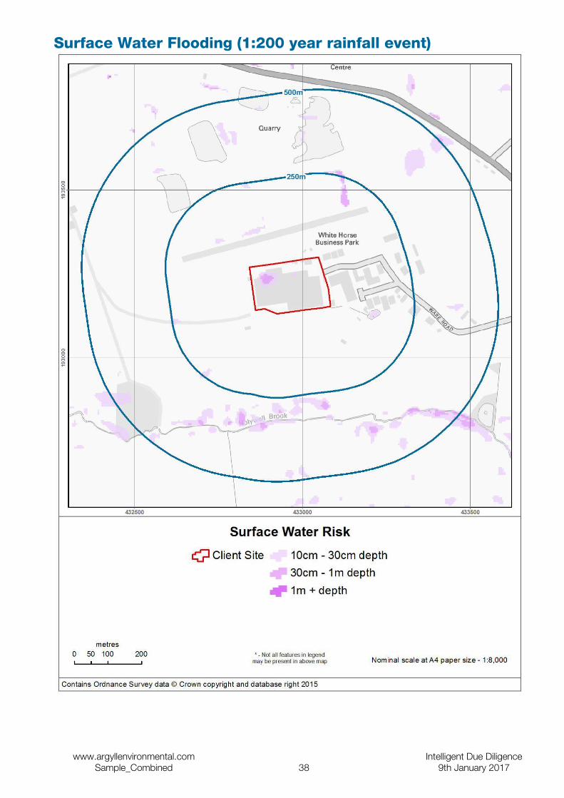
Surface Water Flooding (1:200 year rainfall event)
www.argyllenvironmental.com Intelligent Due DiligenceSample_Combined 38 9th January 2017

Surface Water Flooding
Details Distance Reply or Direction
What is the risk of surface water flooding at the Site following a 1 in 75 year rainfall event?
On Site medium
What is the risk of surface water flooding at the Site following a 1 in 200 year rainfall event?
On Site medium
What is the risk of surface water flooding at the Site following a 1 in 1,000 year rainfall event?
On Site medium
JBA Risk Management Data
Surface Water Flooding - Information regarding the risk of natural surface water or pluvial flooding. The risk is classified by JBA into four categories, negligible, low (more than 0.1m), medium (more than 0.3m) and high (more than 1m) which reflect varying depths of potential surface water flooding during a range of rainfall events including 1:75 year, 1:200 year and 1:1,000 year events.
www.argyllenvironmental.com Intelligent Due DiligenceSample_Combined 39 9th January 2017
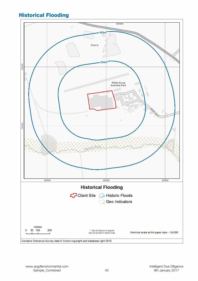
Historical Flooding
www.argyllenvironmental.com Intelligent Due DiligenceSample_Combined 40 9th January 2017
Historical Flood Events
Details Distance Reply or Direction
Have any historic flood events occurred at the Site or within 500m? <501m NO
The regulatory body's records have no indication of past flooding within 500m of the Site. As these records are not comprehensive, it may still be prudent to ask the relevant authorities and the Site owner whether they are aware of any previous flooding at the Site or in the surrounding area.
The Environment Agency Data
The Environment Agency has collated extensive records (including outlines) of flooding from rivers, the sea, or groundwater which have occurred in England and Wales since c.1950. This information comes from various sources including maps, aerial photographs, and private records. It is not necessarily comprehensive.
Geological Indicators of Flooding
Details Distance Reply or Direction
Are there any geological deposits which indicate the Site may have been flooded in the past?
<26m NO
Data from the British Geological Survey (BGS) indicates that the type of deposits in the locality of the Site are not of the type normally associated with floodplains. However, this data should only be considered as complementary to the regulatory body's Flood Map. This BGS data does not indicate the likelihood of flooding, since such deposits may be due to flood events which occurred thousands of years ago. Refer to the other assessments in this report for an overall assessment of flood risk.
British Geological Survey Data
Geological Indicators of Flooding – The BGS Geological Indicators of Flooding (GIF) data set is a digital map based on the BGS Digital Geological Map of Great Britain at the 1:50,000 scale (DiGMapGB-50). It was produced by characterising Superficial (Drift) Deposits on DiGMapGB-50 in terms of their likely vulnerability to flooding, either from coastal or inland water flow and reflects areas which may have flooded in the recent geological past. This normally relates to flooding which happened many thousands of years ago.
www.argyllenvironmental.com Intelligent Due DiligenceSample_Combined 41 9th January 2017
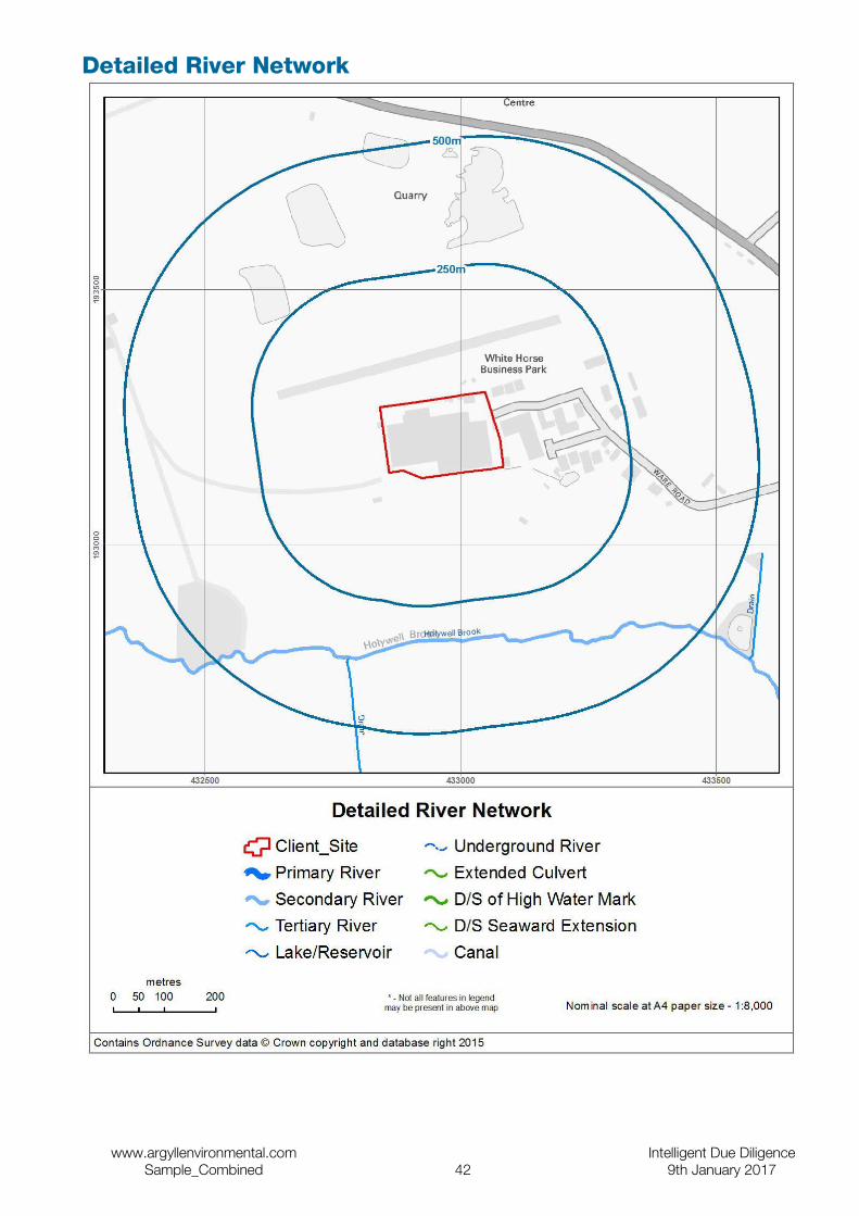
Detailed River Network
www.argyllenvironmental.com Intelligent Due DiligenceSample_Combined 42 9th January 2017
Other Information
Detailed River Network
Details Distance Reply or Direction
Is there any information from the EA's Detailed River Network within 500m? <501m YESRiver Name: Holywell Brook, Watercourse Name: , Is The Feature a Main River?: NO, Is The Feature a Drain?: NO.
317.1m S
River Name: Drain, Watercourse Name: , Is The Feature a Main River?: NO, Is The Feature a Drain?: YES.
368.5m S
There is a river, canal, or drainage channel identified by the regulatory body's detailed river network within 500m of the Site however this is not currently classified as a Main River by the regulatory body. This does not represent a flood risk in itself, but its presence has been taken into account in the overall risk assessment in this Report.
The Environment Agency Data
This data was derived from Ordnance Survey Mastermap (the UK’s most detailed digital mapping) and shows the centre-lines of the river network (rivers, drains and streams) in England and Wales. Where relevant, it assigns attributes such as river type and designation (i.e. Main River status). It can be important to know this because certain statutory bodies must be consulted about development proposals near to a Main River, canal or drainage channel.
Height Above Sea Level
Details Distance Reply or Direction
Maximum height of the Site above sea level On Site 81.30mMinimum height of the Site above sea level On Site 77.40mAverage height of the Site above sea level On Site 79.47m
The Site is at a relatively high elevation above sea level. However, this is not in itself indicative of the absence of flood risk and reference should be made to other assessments within this report.
www.argyllenvironmental.com Intelligent Due DiligenceSample_Combined 43 9th January 2017

Distance to Water Features
Details Distance Reply or Direction
Are there any water features within 500m? <501m YESNearest water feature 93.0m NNearest water feature 99.0m NNearest water feature 315.9m SNearest water feature 335.6m SNearest water feature 378.0m NWNearest water feature 386.9m SENearest water feature 407.7m NNearest water feature 453.9m SWNearest water feature 457.2m N
There is a water feature shown on the Ordnance Survey within 250m of the Site. This does not represent a flood risk in itself, but its presence has been taken into account in the overall risk assessment in this Report.
www.argyllenvironmental.com Intelligent Due DiligenceSample_Combined 44 9th January 2017

Dam or Reservoir Failure
Details Distance Reply or Direction
Is there a risk of the Site being affected by the failure of a nearby dam or reservoir? On Site NO
Neither the Site nor areas near to it will be likely to flood if a dam or reservoir in the surrounding area failed.
JBA Risk Management Data
Dam or Reservoir Failure – JBA has modelled approximately 1700 dams and reservoirs across the UK which are considered to pose the greatest risks to people and property. These models are able to predict the areas likely to flood on all sides of a feature, should an element of it fail e.g. a wall, dam or earth bund.
www.argyllenvironmental.com Intelligent Due DiligenceSample_Combined 45 9th January 2017
Useful Contacts
Name and Address Telephone/Fax/EmailArgyll Environmental Limited1st Floor98 – 99 Queens RoadBrightonBN1 3XFwww.argyllenvironmental.com
General enquiries 0845 458 5250
Ensura Limited (for Environmental Insurance)1st Floor98 – 99 Queens RoadBrightonBN1 3XFwww.ensura.co.uk
Telephone 0845 652 8585
Fax 0845 652 8686
Vale of White Horse District Council Environmental Health DepartmentThe Abbey Housewww.whitehorsedc.gov.uk
Telephone 01235 520202
Fax: 01235 540396
Environment Agency National Customer Contact Centre (NCCC)PO Box 544
Telephone 03708 506 506
Oxfordshire County CouncilCounty Hallwww.oxfordshire.gov.uk
Telephone 01865 792422
Fax: 01865 810106
British Geological Survey Enquiry ServiceBritish Geological Surveywww.bgs.ac.uk
Telephone 0115 936 3143
Fax: 0115 936 3276
Department for Environment, Food and Rural Affairs (DEFRA - formerly FRCA)Government Buildings
Telephone 0113 2613333
Fax: 0113 230 0879
Natural EnglandCounty Hallwww.naturalengland.org.uk
Telephone 0300 060 3900
Environment Agency National Customer Contact Centre (NCCC)PO Box 544TempleboroughRotherhamS60 1BYwww.environment-agency.gov.uk
General enquiries 08708 506 506
Floodline 0845 988 1188
British Geological Survey Enquiry ServiceBritish Geological SurveyKingsley Dunham CentreKeyworthNottinghamNG12 5GGwww.bgs.ac.uk
General enquiries 0115 936 3143
Fax 0115 936 3276
(For advice on flood insurance)
British Insurance Brokers' Association 8th FloorJohn Stow House8 Bevis MarksLondonEC3A 7JB
Consumer helpline 0870 950 1790
JBA Risk Management - Head OfficeSouth BarnBroughton HallSkiptonNorth YorkshireBD23 3AE
General enquiries 01756 799 919
Fax 01756 799 449
www.argyllenvironmental.com Intelligent Due DiligenceSample_Combined 46 9th January 2017

Name and Address Telephone/Fax/EmailPlease note that the Environment Agency / SEPA have a charging policy in place for enquiries. When contacting these agencies please mention that this data has been received from the Landmark database, alternatively Argyll Environmental Limited would be pleased to assist with consultation to the above bodies. Please contact us for a quotation.
www.argyllenvironmental.com Intelligent Due DiligenceSample_Combined 47 9th January 2017
Contamination Land Risk Analysis MethodologyThe SITESOLUTIONS reports have been designed to assist in making informed decisions during property transactions. This section of the Report is a desktop assessment of direct liabilities (Liabilities) which could affect the owner /occupier of the Site and arise under Part 2A of the Environmental Protection Act 1990 and/or equivalent requirements under the planning regime and/or the Water Resources Act 19914. (Relevant Legislation). If a risk is identified, then a number of options for finding out more about the risk, managing it or transferring it are proposed.
The assessment of environmental liability under the Relevant Legislation is based upon the principle of determining the presence of a plausible contaminant-pathway-receptor relationship (a contaminant linkage). A ‘contaminant’ is a source of contamination, a ‘pathway’ is a medium through which the contamination can mobilise and ‘a receptor’ is a person or entity that could be detrimentally affected by the contamination. If all three are identified, then a 'plausible contaminant-pathway-receptor relationship' may be present. By definition, this is one which Argyll believes could result in significant harm, a significant possibility of significant harm or significant pollution or the possibility of significant pollution to Controlled Waters.
In our assessment we use the following test to decide if there is a potential liability affecting the Site. For the purpose of this assessment a site where a potential Liability has been identified is defined as follows:
A Site which, from the information assessed by Argyll, is considered to have the potential of being affected by contaminative substances present in or under the Site (but excluding potential sources of contamination on or above the land) such that, on the basis of its current or proposed use, there is a reasonable likelihood of a UK regulatory authority, acting in accordance with Relevant Legislation, requiring that remedial measures are taken in order to remedy or mitigate the contaminative substances that are present in or under the land that forms all or part of the Site.
The term Liabilities is defined within the scope of this assessment to mean, remedial works under Part 2A of the Environmental Protection Act 1990 (or where appropriate, equivalent requirements under the planning regime) and/or the Water Resources Act 1991 which may result in direct liability for the site owner/occupier.
The assessment within this section of the Report has been produced and quality checked by a team of qualified environmental professionals. The assessment is based upon a manual review of the data contained within the Data Section of this Report and of 1:2500 and 1:1250 (where available) scale historical mapping.
Ecological Risk AssessmentThe evaluation of ecological risk is becoming an increasingly important input when making risk management decisions. In the Site Solutions Commercial report, Argyll assesses two different drivers for risks and liabilities driven by ecological receptors;
1. The Contaminated Land Regime; and
2. The Environmental Damage Regulations 2009, as amended (EDR).
The Environment Agency has designed a generic framework for conducting ecological risk assessment (see Assessing Risk to Ecosystems from Land Contamination, R&D Technical Report P299, EA 2002). This recommends a tiered approach in line with best practice for human health and controlled water risk assessment and defines Relevant Ecological Receptors as any of the Relevant Types of Receptor as set out in Table 1 of Defra Statutory Guidance on Contaminated Land dated April 2012.
Argyll assesses Relevant Ecological Receptors as part of its assessment process. To do so it uses the Argyll EcoRisk model which was developed and tested in consultation with leading experts and is based on the Environment Agency framework.
The Environmental Damage (Prevention and Remediation) Regulations 2009, as amended, were introduced on 1 March 2009 to implement the provisions of the European Union's Environmental Liability Directive into law in England5. The aim of EDR is to prevent and remedy damage to protected species or natural habitats or a site of special scientific interest, surface water, groundwater, coastal water or to land. 'Environmental damage' has a specific meaning in the Regulations, and must meet key criteria. Existing legislation with provisions for environmental
4 Water Environment (Controlled Activities)(Scotland) Regulations 2005 where appropriate.5Environmental Damage (Prevention and Remediation) (Wales) Regulations 2009 or Environmental Liability (Scotland) Regulations 2009 where appropriate.
www.argyllenvironmental.com Intelligent Due DiligenceSample_Combined 48 9th January 2017
liability remains in place. The Regulations apply on land in England and on the seabed around the UK up to the limits set out in the Continental Shelf Act 1964, and to waters out to the Renewable Energy Zone, which extends approximately 200 miles out to sea.
Argyll will apply due consideration to the nature of any activities likely to be occurring on Site and review EDR Receptors surrounding the Site. However, Argyll are unable to consider the standard of current operations or instances where environmental damage arises either intentionally or as a result of negligence on behalf of the Site operator.
The assessment excludes the identification of potential liabilities arising as a result of genetically modified organisms and the transportation or delivery of polluting goods which may occur at locations off Site. In addition, not all EDR Receptors can be identified in this assessment including protected species/natural habitats such as nesting bats, nesting birds or migratory bird routes which are not officially designated.
When conducting either assessment, Argyll will primarily assess information provided in the Data section of the Report. However, in some cases Argyll may choose to supplement this with freely available public information such as that provided by Natural England and/or information provided by the Argyll Europa System.
Liability AssessmentIn this section Argyll will report on any potential soil and groundwater liabilities which it considers are associated with the Site. Our assessment of Liability is based upon the proposed and current use of the Site (as supplied by the client) in line with current Government guidance. There will be one of the following three responses:
Assessment Liability Statement & explanation Defra Category*
PASSED Within the scope of this assessment no Liabilities have been identified. No further action is required.
This statement indicates that within the scope of this assessment, no issues have been identified that are likely to result in significant cost liabilities under Relevant Legislation.
3 or 4
PASSED Within the scope of this assessment no Liabilities have been identified. However, your attention is drawn to the prudent enquiries suggested below.
This statement indicates that within the scope of this assessment, no issues have been identified that are likely to result in significant cost liabilities under Relevant Legislation. However, a client may wish to obtain further information about other issues disclosed in the Report, which could be material.
3 or 4
FURTHER ACTION
Potential Liabilities have been identified under Part 2A of the Environmental Protection Act 1990 (or where appropriate, equivalent requirements under the planning regime) and/or the Water Resources Act 19916. To quantify these you may decide to undertake a more detailed assessment through the recommendation(s) set out below.
This statement indicates that within the scope of this assessment, an issue or a number of issues have been identified that are likely to result in significant cost liabilities under Relevant Legislation. In this event, recommendations are made, in order that additional information is collected so that the liabilities may be more accurately assessed.
Potentially 1 or 2
* According to Defra's updated Statutory Guidance on Contaminated Land, Regulators have a four-stage test to decide when land is and is not contaminated. Category 1 and Category 2 sites would encompass land which is capable of being determined as contaminated land, whereas Category 3 and Category 4 sites would encompass land which is not capable of being determined as contaminated land.
Limitations of the ReportThe SITESOLUTIONS reports have been designed to satisfy standard environmental due-diligence enquiries, as recommended by the Law Society's contaminated land warning card. It is a ‘remote’ investigation and reviews only
6Water Environment (Controlled Activities)(Scotland) Regulations 2005 where appropriate.
www.argyllenvironmental.com Intelligent Due DiligenceSample_Combined 49 9th January 2017
information provided by the client and from the databases of publicly available information that have been chosen to enable a desk based environmental assessment of the Site. The Report does not include a site investigation, nor does Argyll make specific information requests of the regulatory authorities for any relevant information they may hold. Therefore, Argyll cannot guarantee that all land uses or factors of concern will have been identified by the Report.
The information in the Data Section of the Report is derived from a number of statutory and non-statutory sources. While every effort is made to ensure accuracy, Argyll cannot guarantee the accuracy or completeness of such information or data. Argyll will not accept responsibility for inaccurate data provided by external data providers.
Further information regarding our risk assessment methodology is provided in the Products and Services User Manual which is available free of charge from the client area of our website www.argyllenvironmental.com. For further information regarding the datasets reviewed within our assessment, please contact one of our technical team on 0845 458 5250. This report is provided under The Argyll Environmental Limited Conditions of Contract for SITESOLUTIONS and FLOODSOLUTIONS Reports (May 2011), a copy of which is available on our website.
Flood Risk Screening MethodologyThis section of the report is a desktop flood risk screening report, designed to enable property professionals to assess the risk of flooding at commercial sites. It examines three areas; how flood risk affects the availability of insurance for a site; how flood risk affects the potential to redevelop a site; and the overall risk of flooding at a site (taking into account any flood defences present). The report considers current Government guidance including the National Planning Policy Framework (NPPF). The report has been produced and quality-checked by a qualified consultant using the data contained in this report.
Executive Summary and Consultants CommentIn this section Argyll will summarise in a statement whether any significant flood risks have been identified and whether insurance is likely to be available at Standard Terms.
There will be one of the following three responses:
Assessment Risk Statement
PASSED Low and Low to Moderate - The site is not considered to be at significant risk of flooding. No further action is considered necessary.
PASSED Moderate - Data suggest that there are features which may present a flood risk to the site and its occupants during an extreme flood event. However, buildings and contents insurance should easily be available in most cases.
FURTHER ACTION
Moderate to High and High - This report reveals significant flood risk issues which should be addressed. Further assessment is recommended in order to clarify the risk of flooding at the site and to determine appropriate flood protection measures.
Insurance AvailabilityArgyll provides an indication of whether the Site is likely to be insurable for flood risk at standard terms. The answer to Question1 (on page 3) is based on consideration of Risk of Flooding from Rivers and Sea data supplied by The Environment Agency and surface water flooding data supplied by JBA Risk Management. This data is used by a significant proportion of the insurance industry to help determine the suitability of a Site for insurance, although they may access additional information which could affect their assessment.
Under the Association of British Insurers' Revised Statement of Principles on the Provision of Flooding Insurance (July 2008), the general policy of member companies is that flood insurance for domestic properties and small businesses should continue to be available for as many customers as possible until 1st July 2013, by which time a
www.argyllenvironmental.com Intelligent Due DiligenceSample_Combined 50 9th January 2017
longer term solution should be implemented. The premiums charged and other terms will reflect the risk of flooding but insurance will be available:
1. for properties where the flood risk is not significant (generally defined as no worse than 1.33% or 1–in-75 years annual probability of flooding); and
2. to existing domestic property and small business customers at significant risk, providing the Environment Agency has announced plans to reduce that risk within five years, such as improving flood defences. (The commitment to offer cover will extend to the new owner of any applicable property subject to satisfactory information about the new owner).
However, for significant risk areas where no improvements in flood defences are planned, and in all cases other than domestic properties and small businesses, insurers cannot guarantee to provide cover, but will examine the risks on a case-by-case basis. The implementation of the revised Statement of Principles depends on action from the Government and is continually reviewed by insurers. In addition, the revised Statement of Principles does not apply to properties built after 1st January 2009. Different guidance applies to these (see Climate Change – Guidance on Insurance Issues for New Developments from www.abi.org.uk).
The responses to the question 'Is the Site likely to be insurable at standard terms?' assume the Site is an existing domestic property or small business and makes no allowance for previous claims arising from any type of flooding, nor for non-flood related risks such as subsidence.
Response Meaning
Yes The Site is likely to be considered acceptable by insurance companies at standard terms and flood insurance should not be difficult to obtain. No further action required.
No The Site is not likely to be considered acceptable by insurance companies at standard terms, on the basis of current information. Further work may be required in order to obtain acceptable insurance terms for the flood risk. This could include a more detailed risk assessment or the use of accredited products, flood resilient materials and temporary defences to defend the property.
Development Risk Argyll comments on whether a full or partial Flood Risk Assessment (FRA) would be required in accordance with National Planning Policy Framework (NPPF). The answer to Question 1 is indicative only and is based on the size of the Site (as supplied by the client) and the information in the data section of this report.
NPPF sets out Government policy on development and flood risk. Its aims are to ensure that flood risk is taken into account at all stages in the planning process to avoid inappropriate development in areas at risk of flooding, and to direct development away from areas of highest risk. Where new development is exceptionally necessary, NPPF aims to make it safe, without increasing flood risk elsewhere, and, where possible, reducing flood risk overall.
A separate Drainage Impact Assessment may be required in addition to an FRA to demonstrate that development of the Site will not adversely affect flood risk elsewhere.
Response Meaning
Yes (Full) If the Site was redeveloped, a full Flood Risk Assessment is likely to be required which should include a Drainage Impact Assessment.
Yes (Drainage) If the Site was redeveloped, a full Flood Risk Assessment may not be required however, given the size of the Site, a Drainage Impact Assessment may be necessary.
No If the Site was to be redeveloped, no further flood assessment is likely to be required.
Flood Risk RatingArgyll provides an overall flood risk rating based on an assessment of the data provided within this report. It does so by asking two questions:
2. What is the overall risk of flooding, assuming flood defence fail or are absent or overtopped?
The answer to Question 2 provides a worst case scenario assuming there are either no defences in the area, that any defences in the area could fail, primarily as a result of river or coastal flooding, or are overtopped by excessive flood volumes.
3. Are there existing flood defences which might benefit the Site?
The answer to Question 3 is based on the presence of any flood defences in the dataset provided by the Environment Agency within 500m of the Site. It should be noted that a residual risk of flooding may be present if
www.argyllenvironmental.com Intelligent Due DiligenceSample_Combined 51 9th January 2017
such defences failed. Flood defences do not generally protect the Site against groundwater and surface water flooding.
If defences are present within 250m, a further question is asked:
4. What is the risk of flooding when these defences are operational?
This assesses the risk from flooding, assuming these defences work as intended and neither fail nor are overtopped.
Questions 2 and 3 are answered by one of six standard responses:
Response Meaning
Negligible The overall flood risk rating for the Site is assessed to be 'Negligible'. Existing datasets do not indicate any risk at the Site itself, or any feature within the locality of the Site, which would be expected to pose a threat of flooding. It is not considered that any further investigations are necessary in regard to flood risk.
Low The overall flood risk rating for the Site is assessed to be 'Low'. Although large sites (over 1 ha) would require a Drainage Impact Assessment to accompany any planning application, it is not considered necessary to undertake any other further investigations into the flood risk to the Site.
Low to Moderate The overall flood risk rating for the Site is assessed to be 'Low to Moderate'. The presence of such features as flood defences, flood storage areas and watercourses within the locality of the Site suggests that there may be a risk of flooding to the Site itself. Further investigations could be undertaken to further assess this risk.
Moderate The overall flood risk rating for the Site is assessed to be 'Moderate'. Information from existing datasets suggests that there are certain features which may present a risk to the Site and its occupants. Further assessment would normally be suggested as a prudent measure to clarify the risk of flooding at the Site.
Moderate to High The overall flood risk rating for Site is assessed to be 'Moderate to High'. Information from existing datasets suggests that there are certain features which may present a significant risk to the Site and its occupants. Further assessment is usually recommended in order to clarify the risk of flooding at the Site.
High The overall flood risk rating for Site is assessed to be 'High', with a consequent risk to life and property. This means that existing datasets reveal significant flood risk issues which need to be addressed. Further assessment is usually recommended in order to clarify the risk of flooding at the Site.
Flood AnalysisThe flood risk gauges provide a more detailed analysis of the risk from each of the four main types of flooding – river, coastal, groundwater and surface water. In addition, a fifth gauge provides an analysis of other factors (i.e. historic flood events, geological deposits which are indicative of past flooding, proximity to surface water features and elevation above sea level) that may affect the overall flood risk. For surface water flooding, only the risk rating generated from the 1:200 year rainfall event data is included in the overall risk assessment. The data on 1:75 year and 1:1,000 year rainfall events is provided for information only. For further information on each of these types of flooding, please refer to the Argyll FloodSolutions User Guide.
This analysis takes into account any existing flood defences that are intended to protect the Site and assumes that these work as designed. The analysis also takes into account the other information contained in those data sections of the report which are relevant to that particular type of flooding. The assessment of the risk as shown in the flood gauge should therefore take priority over the information in the individual data sections of the report.
Limitations of the ReportThe report has been designed to satisfy basic flood-related environmental due-diligence enquiries for commercial properties. It is a desktop review of information provided by the client and from selected private and public databases. It does not include a site investigation, nor are specific information requests made of the regulatory authorities for any relevant information (other than local water and sewerage providers). Therefore, Argyll cannot guarantee that all issues of concern will be identified by this report, or that the data and information supplied to it by third parties is accurate and complete.
This report includes an assessment of surface water flooding which examines the risk of the general drainage network overflowing during periods of extreme rainfall. This report does not make a detailed site-specific assessment of the suitability of the existing drainage on the Site. If this is required, then a site survey should be considered. The assessment of pluvial flooding does not take into account particular local or temporary factors that may cause surface water flooding such as the blockage or failure of structures on or within watercourses, drains, foul sewers, water mains, canals and other water infrastructure; and any history of drains flooding at the Site or in
www.argyllenvironmental.com Intelligent Due DiligenceSample_Combined 52 9th January 2017
the locality. Surface water flooding can occur before surface water reaches the general drainage network, for example on hills and inclines.
The Risk of Flooding from Rivers and Sea dataset provided by The Environment Agency does take account of failure of flood defences but does not take into account particular local or temporary factors such as blockage. Environment Agency data does not include flood risk from very small catchments as models of such small scale catchments are not considered to be reliable for UK-wide flood risk assessments. The potential impact of climate change on flood risk to the Site would require further study.
When answering any questions within this report, current applicable legislation is taken into account.
The data used in this report may have inherent limitations and qualifications. Further details are set out in the FloodSolutions User Guide which is available free of charge from our website www.argyllenvironmental.com , or by calling one of our technical team on 0845 458 5250.
This report is provided under The Argyll Environmental Limited Conditions of Contract for SITESOLUTIONS and FLOODSOLUTIONS Reports (July 2013), a copy of which is available on our website, www.argyllenvironmental.com or by calling one of our technical team on 0845 458 5250
Flood GlossaryBusiness Continuity PlanA business continuity plan is a strategic plan of action for a business to implement in an emergency (i.e. flood event). This plan ensures a business can continue to operate during emergency situations and reduces the risk of suffering avoidable losses. For example, it may cover such items as emergency accommodation and computer back up off site.
Flood Evacuation PlanA flood evacuation plan sets out clear steps to ensure the safe evacuation of staff during a flood. It will form part of the Business Continuity Plan.
Coastal FloodingCoastal flooding is the inundation of land areas along the coast caused by sea water rising above normal tidal conditions. Coastal flooding can arise from a combination of high tides, wind induced tidal surge, storm surge created by low pressure and wave action.
Flood Resistance MeasuresThese measures are designed to prevent flood water from entering the buildings on Site.
Flood Resilience MeasuresThese measures are intended to make buildings more resilient to flood damage so that they recover more quickly from flooding. They are not designed to prevent flood water entering the property.
Flood Risk AssessmentA full Flood Risk Assessment (FRA) Report is a bespoke report required under NPPF for any development site within Environment Agency Flood Zones 2 or 3 and/or any development site larger than 1 hectare. These reports are generally prepared following liaison with the Local Planning Authority and the application of the sequential test.
Flood Zone 1An area of low probability of flooding as defined by the Environment Agency – a flood return period of 1 in 1,000 or more.
Flood Zone 2An area of medium probability of flooding as defined by the Environment Agency – a flood return period between 1 in 100 to 1 in 1,000 for river flooding and 1 in 200 to 1 in 1,000 for coastal flooding.
Flood Zone 3aAn area of high probability of flooding as defined by the Environment Agency – a flood return period between 1 in 20 to 1 in 100 for river flooding and 1 in 200 for coastal flooding.
www.argyllenvironmental.com Intelligent Due DiligenceSample_Combined 53 9th January 2017
Flood Zone 3bThis area is a functional floodplain as defined by the Environment Agency. It is an area which is designed to flood – a flood return period of 1 in 20 or less.
Groundwater FloodingGroundwater flooding occurs when ground water levels increase sufficiently for the water table to intersect the ground surface. Groundwater flooding can occur in a variety of geological settings including valleys and in areas underlain by chalk, and in river valleys with thick deposits of alluvium and river gravels.
NPPFThis relates to the National Planning Policy Framework and the associated Technical Guidance.
Pluvial (Surface Water) FloodingPluvial flooding results from rainfall running over ground before entering a watercourse or sewer. It is usually associated with high intensity rainfall events (typically greater than 30mm per hour) but can also occur with lower intensity rainfall or melting snow where the ground is already saturated, frozen, developed (for example in an urban setting) or otherwise has low permeability.
Return PeriodReturn periods are a measure of how likely flooding is to occur. They are commonly expressed as a ratio (for example 1 in 75 or 1:75). This means that this level of flooding is expected once in every 75 years.
River FloodingRiver flooding mainly happens when the river catchment (that is the area of land that feeds water into the river and the streams that flow into the main river) receives greater than usual amounts of water (for example through rainfall or melting of snow). The amount of runoff depends on the soil type, catchment steepness, drainage characteristics, agriculture and urbanisation as well as the saturation of the catchment. The extra water causes the level of the water in the river to rise above its banks or retaining structures.
www.argyllenvironmental.com Intelligent Due DiligenceSample_Combined 54 9th January 2017
Important Consumer Protection InformationThis search has been produced by Argyll Environmental Ltd, 1st Floor, 98 – 99 Queens Road, Brighton, BN1 3XF. Telephone: 0845 458 5250, e-mail: [email protected] which is registered with the Property Codes Compliance Board (PCCB) as a subscriber to the Search Code. The PCCB independently monitors how registered search firms maintain compliance with the Code.
The Search Code:
• provides protection for homebuyers, sellers, estate agents, conveyancers and mortgage lenders who rely on the information included in property search reports undertaken by subscribers on residential and commercial property within the United Kingdom
• sets out minimum standards which firms compiling and selling search reports have to meet
• promotes the best practice and quality standards within the industry for the benefit of consumers and property professionals
• enables consumers and property professionals to have confidence in firms which subscribe to the code, their products and services.
By giving you this information, the search firm is confirming that they keep to the principles of the Code. This provides important protection for you.
The Code's core principles
Firms which subscribe to the Search Code will:
• display the Search Code logo prominently on their search reports
• act with integrity and carry out work with due skill, care and diligence
• at all times maintain adequate and appropriate insurance to protect consumers
• conduct business in an honest, fair and professional manner
• handle complaints speedily and fairly
• ensure that products and services comply with industry registration rules and standards and relevant laws
• monitor their compliance with the Code
Complaints
If you have a query or complaint about your search, you should raise it directly with the search firm, and if appropriate ask for any complaint to be considered under their formal internal complaints procedure. If you remain dissatisfied with the firm’s final response, after your complaint has been formally considered, or if the firm has exceeded the response timescales, you may refer your complaint for consideration under The Property Ombudsman scheme (TPOs). The Ombudsman can award up to £5,000 to you if the Ombudsman finds that you have suffered actual financial loss and/or aggravation, distress or inconvenience as a result of your search provider failing to keep to the Code.
Please note that all queries or complaints regarding your search should be directed to your search provider in the first instance, not to TPOs or to the PCCB.
TPOs Contact Details:The Property Ombudsman schemeMilford House43-55 Milford StreetSalisburyWiltshire SP1 2BPTel: 01722 333306Fax: 01722 332296Web site: www.tpos.co.ukEmail: [email protected]
You can get more information about the PCCB from www.propertycodes.org.uk.
PLEASE ASK YOUR SEARCH PROVIDER IF YOU WOULD LIKE A COPY OF THE SEARCH CODE
www.argyllenvironmental.com Intelligent Due DiligenceSample_Combined 55 9th January 2017

Complaints procedure
If you want to make a complaint, we will:
• Acknowledge it within 5 working days of receipt.
• Normally deal with it fully and provide a final response, in writing, within 20 working days of receipt.
• Keep you informed by letter, telephone or e-mail, as you prefer, if we need more time.
• Provide a final response, in writing, at the latest within 40 working days of receipt.
• Liaise, at your request, with anyone acting formally on your behalf.
Complaints should be sent to:
Legal DirectorArgyll Environmental Ltd1st Floor98 - 99 Queens RoadBrightonBN1 3XF
Telephone: 0845 458 5250Email: [email protected]
If you are not satisfied with our final response, or if we exceed the response timescales, you may refer the complaint to The Property Ombudsman scheme (TPOs): Tel: 01722 333306, E-mail: [email protected]
We will co-operate fully with the Ombudsman during an investigation and comply with his final decision.
www.argyllenvironmental.com Intelligent Due DiligenceSample_Combined 56 9th January 2017