report on potential economic and fiscal impacts of lng
TRANSCRIPT

Yellow Wood Associates, Inc.
1
Report on Potential Economic and Fiscal Impacts of LNG Terminals
on the Whole Passamaquoddy Bay
Prepared for
Save Passamaquoddy Bay
Prepared by
Yellow Wood Associates, Inc. 228 North Main Street
St. Albans, Vermont 05478
June 20, 2006

Yellow Wood Associates, Inc.
2
About Yellow Wood Associates, Inc. Yellow Wood Associates, Inc. (Yellow Wood) of St. Albans, Vermont has twenty years of experience working with rural communities on issues related to community and economic development and natural resource use. Yellow Wood has gained a strong national reputation for creative problem-solving based on thorough research. The firm’s research capability is enhanced by the way we work with our clients to clarify their goals and develop research questions which will yield information for more effective decision-making and productive action.
©2006 Yellow Wood Associates Inc. All rights reserved. Yellow Wood Associates Inc. holds exclusive rights to this material. Any re-publication, re-editing or other use of this material in any form, including by framing or similar means, or by electronic linking, is expressly prohibited without the prior consent of Yellow Wood Associates Inc. Contact Yellow Wood Associates, Inc. at 228 North Main Street, St. Albans, Vermont 05478; (802) 524-6141; Fax (802) 524-6643; Email [email protected]; Web www.yellowwood.org.

Yellow Wood Associates, Inc.
3
Table of Contents INTRODUCTION............................................................................................................................................................ 7
What is the region covered by this study and how was it determined?..................................................................................... 7 Shared History of the Region......................................................................................................................................... 9 Economic Base Characteristics....................................................................................................................................... 9
How do the coastal communities of Passamaquoddy Bay think of themselves and their future? ............................................. 11 What is a Liquid Natural Gas Import Terminal and How Does It Work? ..................................................................... 15
Potential Locations of Generic LNG Terminal ........................................................................................................... 16 Throughput/Sendout Capacity .................................................................................................................................... 17 Pipeline ...................................................................................................................................................................... 17 Shipping Route ........................................................................................................................................................... 18 LNG Transport by Truck ......................................................................................................................................... 20 Number of Vessel Transits per Year ........................................................................................................................... 21
What is the likely secondary industrial development associated with one or more LNG terminals in Passamaquoddy Bay?... 22 ECONOMIC IMPACTS ON EMPLOYMENT........................................................................................................ 22
What is the match between the jobs a generic LNG terminal will provide and the employment capacity of the local population?........................................................................................................................................................................................ 22
Employment Conditions .............................................................................................................................................. 22 Existing Employment Patterns ................................................................................................................................... 23 Commuting Patterns ................................................................................................................................................... 24
Economic and Employment Impacts of LNG Terminals ........................................................................................................ 26 Construction Phase ..................................................................................................................................................... 26 Operation Phase ......................................................................................................................................................... 26 Employment at Sea..................................................................................................................................................... 26
LOCAL IMPACT............................................................................................................................................................. 27 Major Facility Components ......................................................................................................................................... 27 Industry Characterization ........................................................................................................................................... 28 LNG Terminal Construction...................................................................................................................................... 28
Industrial Building Construction .................................................................................................................... 29 Heavy and Civil Engineering Construction................................................................................................... 29 Other Heavy and Civil Engineering Construction....................................................................................... 30 Survey of State, Regional and Local Firms.................................................................................................... 30 Specialty Trade Contractors ............................................................................................................................ 30 Onshore Terminal Capital Expenditures....................................................................................................... 30 Materials and Equipment................................................................................................................................. 31 What Others Have Said ................................................................................................................................... 33
Industry Characterization ........................................................................................................................................... 36 LNG Terminal Operation ......................................................................................................................................... 36 Multipliers.................................................................................................................................................................. 38 Supply Chains ............................................................................................................................................................ 39 Direct and Indirect Effects Estimation......................................................................................................................... 39
Which economic activities that depend on land, air, or marine transportation are likely to be impacted by construction and operation of one or more LNG plants?.............................................................................................................................. 42
Land-Based Transportation: Vehicle Traffic ............................................................................................................... 42 Construction Phase........................................................................................................................................... 42 LNG Transport by Truck................................................................................................................................ 42 Operation Phase-Related Traffic .................................................................................................................... 43
Geographic Range of Impacts....................................................................................................................................... 43 Types of Impacts ......................................................................................................................................................... 43
Traffic Impacts.................................................................................................................................................. 43 Traffic Characteristics ...................................................................................................................................... 43
Level of Service (LOS)................................................................................................................................................ 48 Impacts....................................................................................................................................................................... 49
Safety .................................................................................................................................................................. 49

Yellow Wood Associates, Inc.
4
Shift in Traffic Volume.................................................................................................................................... 49 Emergency Evacuation from LNG Sites ...................................................................................................... 50 Road Condition................................................................................................................................................. 50
Funding Source for Road Improvements ....................................................................................................................... 50 Financial Impacts to Passamaquoddy Bay Communities .............................................................................................. 51
Direct Impacts: Route 1/Route 190 .............................................................................................................. 51 Indirect Impacts: Increased Truck Traffic on State-Aid Highways.......................................................... 51 Indirect Impacts: Increased Truck Traffic on Townways.......................................................................... 51
Land-Based Transportation: Bicycle Traffic ................................................................................................................. 52 Marine-Based Transportation ..................................................................................................................................... 52
Safety/Security of the Transit Route.............................................................................................................. 52 Impacts to Existing Marine Traffic ................................................................................................................ 56
Commercial Traffic ..................................................................................................................................................... 57 Key Informant Interviews ............................................................................................................................... 57
Ferry Traffic ............................................................................................................................................................... 59 Research Vessels......................................................................................................................................................... 60 Fishing ....................................................................................................................................................................... 60 Total Landings – Impacts to the Canadian Side ................................................................................................ 64 Air Transportation..................................................................................................................................................... 65
FISCAL IMPACTS .......................................................................................................................................................... 66 What is the fiscal condition of the study area? ........................................................................................................ 66
Review of Current Fiscal Conditions............................................................................................................................ 67 Local Emergency Response .......................................................................................................................................... 70
Maine .................................................................................................................................................................. 72 New Brunswick................................................................................................................................................. 73
Police Protection.......................................................................................................................................................... 75 Fire Protection ............................................................................................................................................................ 77
Maine .................................................................................................................................................................. 77 New Brunswick................................................................................................................................................. 81
Ambulance and Medical Capacity ............................................................................................................................... 83 Maine .................................................................................................................................................................. 83 New Brunswick................................................................................................................................................. 84
Communications ......................................................................................................................................................... 84 Maine .................................................................................................................................................................. 84 New Brunswick................................................................................................................................................. 86
Access to the Water .................................................................................................................................................... 86 School Capacity and Location ..................................................................................................................................... 87
Public Safety Conclusions................................................................................................................................ 88 What impact will the LNG terminal have on the cost of providing town services in host communities? ..... 88
Town Government Resources and Staffing.................................................................................................................... 88 Estimating Permanent Cost Increases for Host Communities........................................................................................ 89
Local Government Staffing............................................................................................................................. 90 Safety and Security at Sea................................................................................................................................. 92 Transportation-Related Expenses .................................................................................................................. 93 Fire Safety .......................................................................................................................................................... 93 Police Services................................................................................................................................................... 94 Medical Safety ................................................................................................................................................... 94 Housing.............................................................................................................................................................. 94 Sewer and Water ............................................................................................................................................... 95
What is the likely impact of the LNG terminal on property values?.................................................................... 95 Impacts of Industrial Development............................................................................................................................... 96 Interference with Access to the Water ........................................................................................................................... 98 Risk and Nuisance Effects.......................................................................................................................................... 98 Radius of Concern Associated with Land-based LNG Facilities................................................................................ 100
What is the likely impact on property values of one or more LNG terminals?................................................................... 101 Radius of Concern for Properties along the LNG Transit Route ................................................................................ 103
Yellow Wood Associates, Inc.
5
Pipeline Safety. ......................................................................................................................................................... 106 Economic Impacts of Proposed Pipeline Laterals ........................................................................................................ 107
Permanent Right of Way (ROW) ................................................................................................................. 107 Additional Setback.......................................................................................................................................... 107 Combined Impact of Permanent Right-of-Way and Setback................................................................... 108
Observed Impacts to Date of Proposed LNG Terminals on Property Values in Passamaquoddy Bay.......................... 109 Property Tax Tradeoffs ............................................................................................................................................. 109
What are the alternatives to onshore LNG terminals?..................................................................................................... 110 What do experts say about the strengths and future potential of the region’s economy?........................................................ 110
Tourism ................................................................................................................................................................... 112 Potential Areas of Impact of LNG on Tourism......................................................................................... 115
Attracting Retirees and Second Home Owners ........................................................................................................... 115 Fisheries and Aquaculture ........................................................................................................................................ 119 Energy...................................................................................................................................................................... 119
Tidal Power...................................................................................................................................................... 119 Wind Power..................................................................................................................................................... 120 Biomass ............................................................................................................................................................ 120 LNG ................................................................................................................................................................. 121
Economic Diversification ........................................................................................................................................... 121
List of Figures FIGURE 1: LNG FACILITY SHOWING STORAGE TANK, PIER, AND LNG...................................... 15 FIGURE 2: EXCLUSION ZONES FOR LNG STORAGE TANKS.......................................................... 16 FIGURE 3: RELATIVE SIZE OF LNG STORAGE TANK ....................................................................... 17 FIGURE 4: SHIPPING LANE FOR LNG VESSELS FROM THE SOUTH ............................................. 18 FIGURE 5: TYPICAL LNG VESSEL......................................................................................................... 20 FIGURE 6: MAINE COMMUTER INFLOW/OUTFLOW AND NET ...................................................... 25 FIGURE 7: CURRENTS IN THE WESTERN PASSAGE ........................................................................ 54 FIGURE 8: RELATIVE SIZE OF LNG TANKER ..................................................................................... 97 List of Tables TABLE 1: DIFFERENCES BETWEEN GENERIC LNG MODEL AND PROPOSED LNG
DEVELOPMENTS............................................................................................................................. 16 TABLE 2: POTENTIAL PIPELINE SEGMENTS ASSOCIATED WITH THE PROPOSED LNG
FACILITY .......................................................................................................................................... 18 TABLE 3: LNG VESSELS IN THE WORLD FLEET FOR DIFFERENT SIZE CLASSES ..................... 21 TABLE 4: DIMENSIONS OF DIFFERENT SIZE CLASSES FOR LNG SHIPS. ..................................... 21 TABLE 5: NAICS INDUSTRY SECTORS FOR LNG CONSTRUCTION. ............................................. 29 TABLE 6: LNG TERMINAL COMPONENT EXPENDITURES AND SIZE RELATIVE TO PROJECT
TOTAL ............................................................................................................................................... 31 TABLE 7: EQUIPMENT LIST.................................................................................................................... 32 TABLE 8: COMPARISONS OF 1990 TOTAL GROSS STATE PRODUCT (GSP), AND GSP IN THE
OIL AND GAS INDUSTRY .............................................................................................................. 34 TABLE 9: MATERIALS PROPORTIONED BY CONSTRUCTION COMPONENT AND
GEOGRAPHICALLY DISTRIBUTED AS ESTIMATED FOR A PASSAMAQUODDY BAY LNG TERMINAL........................................................................................................................................ 35
TABLE 10: PLANT CONSTRUCTION LABOR AND EXPENDITURES............................................... 36 TABLE 11. DIRECT, INDIRECT, TOTAL EFFECTS OF MAINE CONSTRUCTION EMPLOYMENT.
............................................................................................................................................................ 40 TABLE 12: POTENTIAL IMPACTS TO EXISTING TRAFFIC FLOWS................................................. 44 TABLE 13: TOTAL IMPACTS OF THREE LNG FACILITIES ON SAME ROAD SEGMENTS........... 45 TABLE 14: IMPACT TO EXISTING TRAFFIC FLOW............................................................................ 46 TABLE 15: IMPACT TO EXISTING TRAFFIC FLOW FOR ALL THREE FACILITIES....................... 46 TABLE 16: IMPACTS ASSOCIATED WITH LNG TRANSPORT BY TRUCK ..................................... 47
Yellow Wood Associates, Inc.
6
TABLE 17: FISHING LICENSES............................................................................................................... 63 TABLE 17A: FISHING LICENSE DATA .................................................................................................. 64 TABLE 18: STATE’S 2003 “EQUALIZED” TAX RATE FOR SELECTED COMMUNITIES ............... 68 TABLE 18A: PROPERTY TAX RATES FOR NEW BRUNSWICK COMMUNITIES............................ 70 TABLE 19: FIREFIGHER SALARY TRENDS.......................................................................................... 79 TABLE 20: FISCAL CONSIDERATIONS................................................................................................. 90 TABLE 21: ZONES OF IMPACT AND PROPERTY VALUE DISCOUNT RATES ............................ 101 TABLE 22: NUMBER OF AFFECTED PROPERTIES, THEIR ASSESSED VALUES AND TOTAL
TOWN ASSESSED VALUES ......................................................................................................... 102 TABLE 23: AFFECTED PROPERTIES WITHIN EACH ZONE, ASSESSED VALUES AND VALUE
REDUCTIONS FOR THREE PROPOSED TERMINAL SITES. ................................................... 103 TABLE 24. TRANSIT ZONE AFFECTED PROPERTIES, VALUES AND REDUCTION IN VALUE.
.......................................................................................................................................................... 105 TABLE 25: TOTAL AREA OF 50 FOOT ROW FOR PIPELINE FROM EACH LNG SITE ................ 107 TABLE 26: TOTAL ESTIMATED VALUE OF PROPERTY AND ESTIMATED TAX REVENUE FOR
PROPERTIES WITHIN THE 50 FT ROW FOR PIPELINE FROM EACH LNG SITE ................ 107 TABLE 27: TOTAL AREA OF 150 FOOT SETBACK FOR PIPELINE FROM EACH LNG SITE ..... 108 TABLE 28: TOTAL ESTIMATED VALUE OF PROPERTY WITHIN THE 150 FOOT SETBACK FOR
PIPELINE FROM EACH LNG SITE.............................................................................................. 108 TABLE 29: TOTAL ECONOMIC IMPACT OF 50 FOOT RIGHT OF WAY AND 300 FOOT SETBACK
.......................................................................................................................................................... 108 Appendices Appendix A: Maps Appendix B: Navigation Waypoints with Associated Time/Distance Estimates for LNG Vessel Appendix C: Construction-Related Traffic: Passenger Vehicles Appendix D: Estimated Property Value and Taxes Paid for Property with 50 ft. Construction ROW for Lateral Pipeline from LNG Terminal to Maritimes and
Northeast Pipeline Appendix E: Estimated Property Value and Taxes Paid for Property with 300 foot Setback for Lateral Pipeline from LNG Terminal to Northeast Maritimes Pipeline Appendix F: Responses to Navigation and Safety Questions Sent to Quoddy International Pilots Advisory Group

Yellow Wood Associates, Inc.
7
Potential Economic and Fiscal Impacts of LNG Terminals on the Whole Passamaquoddy Bay INTRODUCTION The purpose of this study is to examine the potential positive and negative economic and fiscal impacts of LNG import terminals on the communities that ring Passamaquoddy Bay. Economic impacts include impacts on income, employment, assets, livelihood, and development choices. Fiscal impacts include impacts on the costs and revenues associated with government. While other studies focus on the statewide economic and fiscal impacts of specific LNG terminals, the purpose of this study is to identify specific impacts that are likely to accrue to host communities, communities near LNG facilities, and communities in the path of, or otherwise affected by, LNG ships and/or pipelines. One or more LNG import terminals anywhere within the target area will have economic and fiscal impacts beyond the host community. Therefore, citizens of three nations, the United States, Canada, and the Passamaquoddy Tribe, have come together to learn about what this type of development may mean to them. What are the potential costs and benefits of one or more LNG import terminals in Passamaquoddy Bay from the perspective of Bay communities? This report is part one of a two-part effort and does not address in detail the economic or fiscal impacts on fisheries, aquaculture, or tourism, which are the economic mainstays of the communities of Passamaquoddy Bay. The focus of this report is on direct employment impacts on local residents and businesses, economic impacts on the real estate market, and fiscal impacts related to community infrastructure, transportation, housing, public safety and property values. Three LNG terminals have been proposed for Passamaquoddy Bay. This is not a study of any specific LNG proposal, but rather a study of the potential impacts of one or more generic LNG import terminals located along the western coast of Passamaquoddy Bay. We assume the location to be anywhere between Devil’s Head in the north and Pleasant Point in the south. A detailed description of the generic model for a Passamaquoddy Bay LNG terminal begins on page 12. What is the region covered by this study and how was it determined? The study area is the communities that ring Passamaquoddy Bay, which include: Robbinston, Perry, Red Beach (Calais), Pembroke, Dennysville, Trescott, Edmunds, Whiting, Lubec, and Eastport in the United States; Black’s Harbour, St. George, St.Andrews, St. Stephen, Deer Island, Grand Manan, and Campobello Island in Canada; and Sipayik (Pleasant Point) in the Passamaquoddy Nation (see Map #1). Canadian territory comprises 2/3 of the Passamaquoddy Bay area. According to Census statistics, none of these communities has a population greater than 5,000 individuals and the combined resident population of the entire area is approximately 29,742. All the U.S. cities, towns and villages lining Passamaquoddy Bay are within Washington County in the State of Maine, while all the Canadian towns, villages, and parishes1 are within Charlotte County in the Province of New Brunswick. The Passamaquoddy Tribe is divided between two principal locations: Pleasant Point on Passamaquoddy Bay, and Indian

Yellow Wood Associates, Inc.
8
Township near the St. Croix River, both in Washington County. The Passamaquoddy Tribe owns more than 200,000 acres in the vicinity of Passamaquoddy Bay, Maine.2 While the majority of the Passamaquoddy Tribe remain on the American side of the border, some Tribal members reside in what is now New Brunswick. Approximately two-thirds of the total study area population, 19,363 people, live in the Canadian portion of the study area; 3,485 (18%) are under the age of 15; 12,780 (66%) are between the ages of 15 and 64, and 3,098 (16%) are over 64.3 There are 10,379 people in the U.S. portion of the study area; 1,972 (19%) are under the age of 15; 6,539 (63%) are between the ages of 15 and 64; and 1,868 (18%) are over 64. These respective figures are 18.5%, 64.3%, and 17.3% for Washington County as a whole. U.S. communities in which one-fifth or more of the population is of retirement age include Calais, Dennysville, Eastport, and Lubec; the only Canadian community in which over one-fifth of the population is of retirement age is Saint Andrews Town, followed by Campobello Parish and Saint Stephen Town at 19%. This compares with 16% for Charlotte County as a whole. The study area’s overall population decreased by 841 residents in the U.S. portion between 1990 and 2000 and grew by 119 residents between 1996 and 2001 in the Canadian portion, for a net decrease of 772 residents or 2 percent of the population. Charlotte County as a whole has been gaining population in contrast to the Province of New Brunswick as a whole. While New Brunswick lost 6,476 people to other provinces from 1998 to 2003, Charlotte County gained 255.4 While there has been a net population decrease, people continue to move into both the U.S. and Canadian portions of the region. Between 1995 and 2001, a total of 980 people moved into the Canadian portion of Passamaquoddy Bay from a different province, territory or country, while 1,119 people moved into the U.S. portion from a different state or country5. Median household income in the study region averages $24,149 ($35,864 Canadian)6 in U.S. communities, ranging from a high of $33,250 ($49,380 Canadian) in Robbinston to a low of $15,956 ($23,696 Canadian) in Pleasant Point. The median household income is $23,315 U.S. ($34,625 Canadian) in Canadian communities, ranging from a high of $28,830 ($42,815 Canadian) in St. George Town to a low of $21,898 ($32,521 Canadian) in Campobello Parish.7 This compares with median household incomes of $25,969 ($38,567 Canadian) for Washington County (2000) and $25,509 ($38,345 Canadian) for Charlotte County (2001). According to Statistics Canada, “A household consists of all people who occupy a housing unit regardless of relationship. A household may consist of a person living alone or multiple unrelated individuals or families living together. A family consists of two or more people, one of whom is the householder, related by birth, marriage, or adoption and residing in the same housing unit.” These are comparable to definitions used by the U.S. Census. Median family incomes, a subset of household incomes, are higher than median household incomes across the board. Official measures of poverty in communities in the study region show 21.9% of individuals in U.S communities were living in poverty in 2000, along with 38.3% of the Passamaquoddy Tribe. This compares with 19% for Washington County as a whole.8 There were 114 families with related children under 5 living in poverty in 1999. This is 4% of all families. At the same

Yellow Wood Associates, Inc.
9
time, 14% of all families in Washington County live in poverty, compared with 15% in study area communities. There were 365 individuals 65 years and over living in poverty.9 In Canadian communities in the study area, the percentage of low-income families ranges from a high of 20% in Saint Stephen Town to a low of 6% in Saint Andrews Parish, with an average of almost 12%. This compares with 13% for Charlotte County as a whole. All but four of the communities (Blacks Harbour Village, Grand Manan Parish, Saint Stephen Parish, Saint Stephen Town) have a smaller proportion of low-income families than Charlotte County as a whole. The total number of families with low incomes is 710, with 285 of these in Saint Stephen Town and the remainder distributed relatively evenly throughout the region10. Poverty designation is based solely on income from all sources and does not take into account self-provisioning or other activities that take place in the informal economy. Shared History of the Region This is not the first time Passamaquoddy Bay residents of the United States, Canada, and the Passamaquoddy Tribe have worked together, but it may be the first time in recent history when there has been a mutual interest in grappling with choices that will affect their shared economic future. People from the three nations in the region designated for this study have historically been connected with one another in a variety of ways. For example, the Passamaquoddy are descendants of Native American peoples that inhabited Maine and Western New Brunswick since before recorded time, and, along with the Penobscot, were among the first Native Americans to have contact with Europeans. The Passamaquoddy fought with the American Colonists against the British. In 1604, Samuel de Champlain made St.Croix Island, in the middle of St. Croix River and within the study area, the scene of the first white settlement north of St. Augustine, Florida. In 1805, the St. Croix Island settlers moved to Nova Scotia. During and after the War of 1812, Canadians and Americans participated in smuggling gypsum across the border at Passamaquoddy Bay. Gypsum was used as a fertilizer for wheat and in making plaster of paris. Efforts by the federal and provincial governments on both sides of the border to shut down smuggling operations were met with strong, united resistance11. Economic Base Characteristics The Passamaquoddy Bay region is a rural area with the largest stretch of relatively undeveloped Atlantic coastline in North America.12 The largest structures on the coast are the old sardine factories in Eastport and the lighthouses. The economic base of the region has been and is currently primarily built on its abundant natural resources, through forestry, agriculture, fisheries, aquaculture, and includes production and processing of raw materials into intermediate and finished goods, as well as shipping and trucking of goods to distant markets. All people in the region, whether Native American, American, or Canadian, have historically relied on the region’s natural resources as economic resources. Eastport is the birthplace of the Maine sardine industry which flourished there from 1875, with the opening of a sardine cannery, to 195013. The Canadian sardine fishery took sardines to Lubec and elsewhere by

Yellow Wood Associates, Inc.
10
boat, rather than by truck (through customs), so dollar figures may not reflect the true value. The sardine and pearl essence (from sardine scales) was very active into the 1980s.14 Although the sardine industry is not as active as it once was, other fishing pursuits including lobstering, scallops, mussels, clams, urchins, other bottom dwellers, groundfish, and aquaculture have partly taken its place. Fish and fish processing remain the dominant industries in Charlotte County today.15 Aquaculture took hold in Washington County in the 1990s and had suffered substantial decline by 2005, yet continues to thrive in Charlotte County.16 Arthur MacKay (director of the St. Croix Estuary Project) started the salmon aquaculture industry on the Atlantic Coast in the 1970s. He built the first site on Deer Island and then built the Eastport facility. The Passamaquoddy invested over $1 million in the NeGoot-Gook Fisheries Center on Grand Manan Island which opened in 2002 with the intention of growing the fisheries business through acquisitions and further investments in value-added products.17 According to John Gilman, author of three books about the Passamaquoddy Bay region,18 the area (both the U.S. and Canadian sides) has been highly dependent on natural resource-based industries, including fisheries, aquaculture, agriculture and now tourism. He explains, “Anything that goes for the U.S. side is the same on the Canadian side. This area was dependent on fishing (very little tourism) until the 1970s, when tourism started to become important. In 1978, salmon aquaculture became popular, when the fisheries (especially the herring/sardine fishery) declined due to overfishing and environmental problems. Boat building was also important. On Deer Island, there was a family that was involved in boat building (fishing boats) for 60-70 years ending in the 1960s. Now most fishing boats in the area are built in Nova Scotia. Agriculture and mining have also been important. This is generally a natural resource-based region.” Residents in coastal communities (not including Passamaquoddy Bay area islands) are connected to the region’s forest products economy as well. Coastal communities in the study area regularly send 345 workers, or 8% of the civilian labor force, to Baileyville where the Domtar paper mill, the region’s largest private employer, is located19. Domtar employs close to 500 people.20 Domtar, in turn, relies on the Port of Eastport to deliver its products overseas.21 Flakeboard Company Limited has a manufacturing plant in St. Stephen, New Brunswick. Many St. Stephen and St. George residents work there. The physical beauty of the region has attracted tourists over many generations. Franklin D. Roosevelt made Campobello Island his summer home. Campobello Island was first developed as a summer resort in the 1880s.22 Tourism is a well-established economic activity in the Canadian portion of the study area, and one widely viewed as having unrealized potential along the American portion of the coastline. The Passamaquoddy Bay “Quoddy Region” is one of, if not the, most productive areas for wildlife on the east coast. The huge tides that rush in twice daily through all of the passages between ledges and islands condense plankton and result in “gardens” of bottom-dwelling invertebrates. These creatures in turn spew larvae and gametes into the water resulting in a localized elevation of productivity that feeds all of the fish, birds, whales, etc. on which regional enterprises depend. It is against this background that this region has developed a greater than one billion dollar annual economy based on fisheries, tourism, aquaculture, and

Yellow Wood Associates, Inc.
11
other resource-based industries. This was calculated from available data and does not include income from: the Maine shore; small ports; research at the Biological Station, Huntsman, ASF; various US groups in Cobscook Bay, real estate, the arts community, etc. This is an important economy that supports thousands of residents on the mainland and islands.23 The history of the study area has left a rich cultural heritage comprised of the rural landscape, historic buildings and other structures, traditional industries, and the living culture of the Passamaquoddy Tribe. Historic resources include: Roosevelt Campobello International Park on Campobello Island, Head Harbour Lightstation on Campobello Island, Owen House on Campobello Island, St. Croix Island at Red Beach in Calais, and the Fairmont Algonquin Resort in St. Andrews. Preserving the rural character of the region is seen as key to the region’s capacity to tap cultural resources for economic gain.24 The promise of untapped natural and cultural resources has been identified as a building block for future development by Fermata25 as well, whose plan for building Maine’s tourism sector focuses on experiential tourism. Today, natural resource-based education and research hold a significant niche in the local economy. The Huntsman Marine Science Center Aquarium and Museum entertains about 30,000 visitors a year in St. Andrews.26 The Quoddy Maritime Museum and Visitors Center in Eastport houses a model of the historic Passamaquoddy Bay Tidal project. The Downeast Heritage Museum in Calais is a new multi-million dollar investment designed to unlock, interpret, and preserve the natural and cultural heritage of Downeast Maine. There’s also the federal biological station in St. Andrews, on the St. Croix River at its mouth. Natural resources also provide the basis for tourism and second home ownership, both of which are important components of the region’s economy. These are the region’s basic industries, serving markets outside the region and bringing “new” dollars into the local economy. In addition to basic industries, the region has some businesses, mostly retail or personal services, which provide goods and services to the local population. The question is not whether the communities in this region could benefit from economic development, but whether or not LNG terminals will move the region closer to its goals. How do the coastal communities of Passamaquoddy Bay think of themselves and their future? The Passamaquoddy Bay area, encompassing Washington County, Maine in the United States and Charlotte County, New Brunswick in Canada, is an area with a significant amount of history relating to its proximity to the water. These are communities whose economies have and, in many cases, continue to be based on the natural resources of the area. Many of the communities have historically been involved in commercial fishing, tourism, shipbuilding, lumbering, milling, etc. Some, like Calais, see water-based industries as “an industry that Calais left behind in an earlier century,” and are ready to move beyond those types of industries to a view of the water as useful for recreation and tourism instead. Others, like Eastport, are guiding their economic development around their status as a port for shipping and marine-based industries. The New Brunswick communities have a similar relationship with the water. Many are dependent on tourism and recreation. Black’s Harbour is home to the world's largest sardine company, Connors Brother Limited (now Bumble

Yellow Wood Associates, Inc.
12
Bee), which is a major provincial employer with a workforce of 4,000 people during peak production periods. These communities think of themselves as small, rural communities where people know each other. Most of the Maine communities have populations of fewer than 1,000 except for the cities and service center communities of Calais (which includes Red Beach), Eastport, and Lubec, which support their surrounding communities in terms of employment, shopping, and culture. The New Brunswick communities are a bit larger, generally between 500 and 2,500 in population. St. Stephen and St. George are the largest New Brunswick communities in our study region. The islands tend to have smaller populations. The populations of the communities in Maine are aging, with fewer and fewer school children. On the Canadian side, the communities of Grand Manan, Campobello Island and St. Andrews have a greater number of seniors than the county and the province. Charlotte County, New Brunswick has a greater percentage of seniors than the rest of the province or Canada as a whole. Many of the communities in our study area recognize the need for sustainable economic development in order to create jobs and build healthy economies. These communities are looking for the types of economic development that do not impact their significant historical, natural and cultural resources. As a result, many are interested in tourism and recreation development, light industry, etc. Their comprehensive plans show the struggle to encourage economic development while maintaining their natural, historical and cultural resources.
Calais’ Comprehensive Plan explains,
“Protecting public shore and water access and maintaining a healthy balance between industry and natural beauty is crucial for future economic development. Investments will be made in infrastructure that increases access to and use of the city’s waterfront. Water quality will be protected and improved through the continued educational, research and regulatory efforts of the city and local resource management agencies.”27
Calais is the eighth busiest border crossing on the U.S./Canada border.28 While once dependent on lumber and shipbuilding, its economy is now based on retail, service and construction businesses. According to the Calais Comprehensive Plan, the economic sectors that will help Calais reach its goals are development associated with the international border and the new bridge to be constructed in 2006-2007, light industry, and tourism, tied closely to concentrated downtown revitalization efforts. Calais has been making significant efforts to create the infrastructure needed to be a tourism destination. For example, a new international bridge will decrease the truck traffic downtown; a Waterfront Development Plan calls for a restored pier, a marina, and more open space to connect Main Street to the waterfront; and a recently completed Downeast Heritage Center located on the waterfront is the focal point of the city’s efforts at becoming a destination. Opened in 2004, this heritage center cost $6 million to develop and construct.
According to its website, the community of St. Stephen has a modest industrial base and has always tried to maintain this industrial character; sometimes successfully, sometimes not. Currently, 10 businesses are located in the industrial park and there are many small
Yellow Wood Associates, Inc.
13
businesses located throughout the area. St. Stephen’s Municipal Plan states that its goals include: “To have the Town identified as the Gateway to Atlantic Canada and to capitalize on this regional role. To support and encourage long term planning for local tourism endeavours. To promote the Town of St. Stephen, as part of the region, for its heritage type buildings and historical significance. To encourage natural recreational activities such as hunting and fishing in the rural areas. To encourage the preservation and promotion of the scenic views.”29
The Town of St. Andrews enumerates one of its objectives, “To allow for further commercial development that is compatible with existing development and the natural and historic character of the Town.” From its current municipal plan, “St. Andrews is a small, seaside town, of approximately 1,700 people, with a rich, unique historic and natural heritage that residents want to preserve and protect for the benefit of themselves, future generations of year-round and seasonal residents, and visitors to the Town.” Among Grand Manan’s objectives is to “plan commercial development so as to maintain the rural character of the fishing communities it serves” and “to limit diversity of the economy to projects that are environmentally suitable for the island.”30
Eastport’s Comprehensive Plan states,
“Eastport retains its character as a commercial port and maritime city. Protecting public shore and water access and maintaining a healthy balance between industry and natural beauty is crucial for future economic development. Maritime industries, both traditional and new, will be supported through access for the commercial fishing fleet, regulatory districts that support maritime activities, and research into ways to diversify aquaculture and other marine trades.”
Eastport’s future focus “is on developing natural resource based industries, specifically those with added value. Diversity is sought by development of the aquaculture, shipping, and tourism industries as the main drivers of the economy. Closely tied to this strategy is a concentrated effort to revitalize Eastport’s historic downtown.” Eastport’s goals for economic development are very straightforward – full employment and a prosperous downtown. The economic sectors that will help Eastport reach those goals are port development, aquaculture and value-added natural resource based industry, light industry, and tourism, tied closely to concentrated downtown revitalization efforts.
The communities in our study area also seek to encourage economic development of a scale and type that is appropriate to their size and location. For example, Grand Manan’s 2004 plan seeks to “allow, in predominantly residential areas, the establishment of small industrial establishments that are compatible with the rural character of these areas that meets the needs of residents.” Heavy industry is only allowed in existing commercial and industrial sites. Other plans cite the importance of small and cottage industries.
Home and cottage-based industries are also important pieces of these local economies, as they are typically at the scale appropriate for these smaller communities. Robbinston’s 1996 Comprehensive Plan concludes that forestry, business expansions, and value-added manufacturing are the keys to its economy in the future.31 Perry’s 1993 Comprehensive Plan acknowledges the high unemployment rate and the dependence on jobs out of town. “As a small, rural town, Perry can do little by itself to improve its economy. The town, however, could undertake an industrial attraction program. It is perhaps more important to work to

Yellow Wood Associates, Inc.
14
preserve existing jobs. Since many local jobs are natural resource-based, this would involve assuring that Perry’s natural resources are protected. The potential for recreational based development should also be considered.”32
In addition, many of these areas seek to continue the trend of natural resource-based businesses and economies. In Grand Manan’s plan, they seek to “encourage the growth and long-term viability of existing resource sectors of the local economy, such as agriculture, forestry, mining, aquaculture and fisheries related industries, in harmony with the environmental protection of the Island.” According to the Saint Andrews Local Service District - Planning Statement 1990, the LSD hopes “to encourage the development of light industry which is non-polluting.”
Infrastructure is necessary to build a strong economy. There is a real need in these communities to maintain and improve infrastructure in order to support the types of growth they are looking to encourage. As many of these towns in Washington County and Charlotte County are small, they do not have a great deal of infrastructure. Many do not have municipal water or sewer service. This limits the potential for economic development within their communities and consigns many of them to being bedroom communities to the larger service center communities.
Many Washington County towns in our study area, such as Eastport, Lubec, and Calais, are undertaking downtown revitalization, to bring more people to their downtowns rather than to the highways bypassing their towns. A focus on small business creation and expansion is a part of this vision.
None of the communities in the study area have articulated a vision for their future that involves transformation from a diversified natural resource-based economy of largely small enterprises to large-scale heavy industrialization based on non-local resources. All communities recognize the importance of retaining existing jobs and developing complementary enterprises. To explore how well one or more liquid natural gas import terminals fit local visions, we have begun by describing a generic LNG facility.

Yellow Wood Associates, Inc.
15
Figure 1: LNG facility showing storage tank, pier and ship
What is a Liquid Natural Gas Import Terminal and How Does It Work? Figure 1: LNG facility showing storage tank, pier, and LNG Summary of a Generic LNG Facility As mentioned earlier, this analysis of potential economic and fiscal impacts resulting from the development of LNG in the region are based on a generic model of an LNG facility. By using a generic model, it is possible to discuss the potential impacts of any of the three proposals in the area or a combination of the three. Yellow Wood developed the specifications for a generic facility by researching existing LNG import terminals in the U.S., as well as the current proposals for the Passamaquoddy Bay area. A generic LNG facility would consist of the following: • A parcel of land, owned by the developer, approximately 80 acres in size, situated on the
waterfront between Devil’s Head and Pleasant Point. • A 3,500 foot pier extending from the shoreline, equipped with mechanical arms to off-
load the LNG from the tankers (pier includes: jetty, trestle/bridge, breasting and mooring dolphins, and unloading platform).
• 130,000 cubic meter LNG vessels arriving at the terminal one out of every 5 ½ days. • Two 160,000 cubic meter LNG storage tanks (approximate outside diameter of 255 ft
each). • A sendout capacity (the total amount of natural gas that is delivered to the grid) of
500,000 million cubic feet per day (182.5 billion cubic feet per year), with the capacity to upgrade to 1 billion cubic feet per day.
• A cryogenic pipe used to convey LNG from the pier to the storage tanks. • Support buildings and an access road. • Boil-off gas (BOG) compressors (used to recapture the heat produced in the
regasification process). • Water bath regasification units used to convert the LNG to a gas for distribution. • Natural gas pipeline connecting the terminal to the Maritimes and Northeast Pipeline,
between 16.9 – 32.7 miles in length. • A permanent right-of-way of 50 feet in width along the length of the connecting
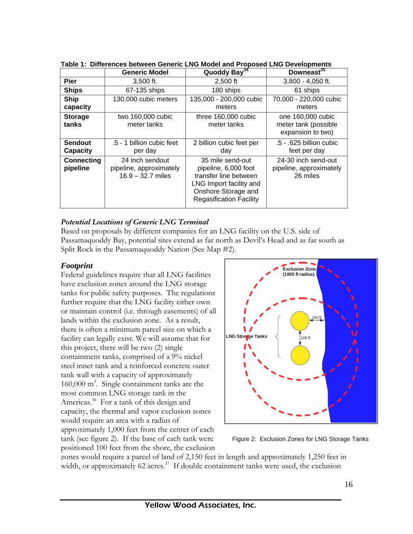
pipeline. • A total cost of construction of $500 million. • An anticipated life span of 25 to 30 years. Since a generic model is being used, there are some differences between it and individual proposals by LNG developers. These differences are summarized in the following table.33
Yellow Wood Associates, Inc.
16
LNG Storage Tanks
100 ft
100 ft
Exclusion Zone (1000 ft radius)
Figure 2: Exclusion Zones for LNG Storage Tanks
Table 1: Differences between Generic LNG Model and Proposed LNG Developments Generic Model Quoddy Bay34 Downeast35 Pier 3,500 ft. 2,500 ft 3,800 - 4,050 ft. Ships 67-135 ships 180 ships 61 ships Ship capacity
130,000 cubic meters 135,000 - 200,000 cubic meters
70,000 - 220,000 cubic meters
Storage tanks
two 160,000 cubic meter tanks
three 160,000 cubic meter tanks
one 160,000 cubic meter tank (possible
expansion to two) Sendout Capacity
.5 - 1 billion cubic feet per day
2 billion cubic feet per day
.5 - .625 billion cubic feet per day
Connecting pipeline
24 inch sendout pipeline, approximately
16.9 – 32.7 miles
35 mile send-out pipeline, 6,000 foot
transfer line between LNG Import facility and Onshore Storage and Regasification Facility
24-30 inch send-out pipeline, approximately
26 miles
Potential Locations of Generic LNG Terminal Based on proposals by different companies for an LNG facility on the U.S. side of Passamaquoddy Bay, potential sites extend as far north as Devil’s Head and as far south as Split Rock in the Passamaquoddy Nation (See Map #2). Figure 2: Exclusion Zones for LNG Storage Tanks Footprint Federal guidelines require that all LNG facilities have exclusion zones around the LNG storage tanks for public safety purposes. The regulations further require that the LNG facility either own or maintain control (i.e. through easements) of all lands within the exclusion zone. As a result, there is often a minimum parcel size on which a facility can legally exist. We will assume that for this project, there will be two (2) single containment tanks, comprised of a 9% nickel steel inner tank and a reinforced concrete outer tank wall with a capacity of approximately 160,000 m3. Single containment tanks are the most common LNG storage tank in the Americas.36 For a tank of this design and capacity, the thermal and vapor exclusion zones would require an area with a radius of approximately 1,000 feet from the center of each tank (see figure 2). If the base of each tank were positioned 100 feet from the shore, the exclusion zones would require a parcel of land of 2,150 feet in length and approximately 1,250 feet in width, or approximately 62 acres.37 If double containment tanks were used, the exclusion

Yellow Wood Associates, Inc.
17
zone would be less. Given additional structures and possible increased setbacks from the coast, for the purposes of this report, we will assume a land area of 80 acres. The figure below illustrates the relative size of a 160,000 m3 storage tank compared to an average house (30 x 40 feet).
Figure 3: Relative Size of LNG Storage Tank
30’ x 40’ House 255’ Diameter LNG Storage Tank
Scale 1 inch = 100 feet
100’
Throughput/Sendout Capacity The total amount of natural gas that an LNG facility produces and delivers to the natural gas grid is referred to as the throughput capacity (also referred to as sendout capacity). We will assume that the sendout capacity for this project will be approximately 500,000 mmcfd (million cubic feet per day). At this rate, the total annual sendout would equal 182.5 BCF (billion cubic feet). In reality, this figure is lower than many of the existing or planned LNG facilities operating in the United States.38 Consequently, it is conceivable, if not likely, that once the facility is in operation, the total throughput will increase to 1,000,000 mmcfd (an annual total of 365 BCF). Pipeline In order to deliver the natural gas to the existing grid for eventual distribution, a new pipeline (lateral) must be constructed to connect the LNG facility to the Maritimes and Northeast Pipeline, which stretches from Nova Scotia, Canada to Massachusetts. The minimum size of the lateral would likely be 24 inches in diameter in order to deliver the anticipated throughput of the facility. Based on the potential location of an LNG terminal, the connector pipeline may be constructed along a number of possible routes (See Map #3). A right-of-way will be required to ensure access to the land along which the lateral will be constructed. The typical width of a construction right-of-way for a natural gas lateral will be approximately 75 feet (approximately 37 feet on either side of the centerline of the pipe). The area within the construction right-of-way will be cleared of trees and vegetation during

Yellow Wood Associates, Inc.
18
the construction phase. If the pipeline parallels existing utility rights-of-way, there may be minimal clearing needed, because the area should already be clear. Once the lateral has been installed, there will be a permanent right-of-way which will likely be 50 feet wide (25 feet on either side of the centerline). In fact, many municipalities are moving toward larger setbacks from natural gas pipelines. The additional setbacks could require an additional 50 feet from all buildings and, in some cases, require a doubling of the initial setback.39 Landowners whose property is in the path of the permanent right-of-way must enter into a legal agreement with the parent company that gives the company access to the right-of-way for maintenance purposes. Within a permanent right-of-way, the following actions are prohibited:
• Construction of buildings or structures • Planting of trees or other vegetation that may obstruct the right-of-way • Excavating, impounding water, or changing the grade of the land. • Moving heavy equipment • Blasting within 1,000 feet of pipeline.40
Based on the potential pipeline routes in Map #3, the minimum distance of a pipeline connecting to the Maritimes and Northeast Pipeline would be approximately 16.9 miles (from Devil’s Head), while the maximum length would be 32.7 miles (from Pleasant Point, along segments A & C). The table below summarizes the pipeline lengths of the different segments shown in Map #3. Table 2: Potential Pipeline Segments Associated with the Proposed LNG Facility
Segment Segment Name Length
(mi.) A Split Rock - Mill Cove 9.1B Mill Cove - MNP 23.6C Mill Cove - MNP 18.6D Mill Cove - MNP 21.9E Devil’s Head – MNP 16.9
From Mill Cove, there are 3 possible pipeline routes (B, C, & D), which pass through different types of land use. Segments B & C would pass through the 1.7 and .7 miles (respectively) of the Moosehorn National Wildlife Refuge. Shipping Route Natural gas in a liquid or vaporized state is not one of Maine’s natural resources. LNG will be shipped into the region from foreign countries. Trinidad and Tobago currently supply approximately 75% of the LNG imported into the United States. Other source countries include Nigeria, Qatar, Oman, Malaysia, Algeria, and soon, Russia. New technology is leading to a growing number of liquefaction plants overseas.41 Figure 4: Shipping Lane for LNG Vessels from the South The transit route from sea to Split Rock consists of passage through the Bay of Fundy to Head Harbour Passage and then on to Western Passage. LNG vessels approaching from the south will likely be directed to the traffic lane east of Grand Manan Island (see Figure 4).

Yellow Wood Associates, Inc.
19
Figure 4: Shipping Lane for LNG Vessels from the South
Approach to Head Harbour
Passage
Grand Manan Channel
Shipping Lane
The Grand Manan Channel was also recently identified as a possible approach to Passamaquoddy Bay. If an LNG facility were to be sited near Devil’s Head, the vessel would also pass through Passamaquoddy Bay and a portion of the St. Croix River. Map #4 is a general overview of the potential LNG transit route, while Maps #5 - #8 show the transit route in more detail.
TRC Companies, Inc.’s Preliminary Navigations/Waterways Analysis and LNG Safety Review for LNG Receiving Terminal at Point Pleasant (sic), Maine indicates that the transit time between the initial waypoint northeast of East Quoddy Head to near Pleasant Point (waypoint 9) is approximately 2 – 2 ½ hours. Based on the distance covered, the average speed is approximately 6 knots. Given this figure, the total transit time by transit leg for all waypoints (1-16) can be seen in the Time Sum column in table 2 (Appendix B). The total transit time to the northernmost point (near Devil’s Head) is approximately 4 hours and 14 minutes if uninterrupted. During transit, the LNG vessel would likely be assisted by 2-4 tug boats and at least one armed U.S. Coast Guard Vessel. Due to the flammable nature of liquefied natural gas and the potential impact of a resulting fire or explosion, safety and security zones are enforced to safeguard the LNG vessels from sabotage and other terrorist activities.42 Federal regulations require a moving safety zone around any LNG vessel; however, the size of the safety zone varies from facility to facility43. Transport Canada is the Canadian agency responsible for

Yellow Wood Associates, Inc.
20
regulating vessel traffic. At this time, Transport Canada does not have a policy relating to safety/security zones for LNG vessels, because there are no vessels currently operating within their jurisdiction. Transport Canada will be considering LNG security zones on a case-by-case basis and is currently in the process of conducting a navigational safety analysis in Head Harbor Passage.44 Given the lack of certainty about the safety/security zones for the proposed developments in the Passamaquoddy Bay area, we can estimate the potential dimensions of these zones by looking at other LNG facilities currently in operation. In Cove Point, Maryland, there is a 500-yard safety zone (nearly 1/3 of a mile), while the Everett, Massachusetts (Boston Harbor) facility requires a safety zone that is 2 miles ahead, 1 mile astern, and 500 yards on either side while the LNG vessel is in transit. For the purposes of this report, we will assume the safety zone to be 1 mile ahead, ½ mile astern (880 yards) and 500 yards on each side. See Map #9 for a graphical representation of the safety zone as applied to an LNG vessel in Head Harbor Passage. Vessels bound for a U.S. port traveling through Canadian waters are piloted by U.S. pilots. Canadian regulations governing LNG transport in Canadian waters are less stringent than those in the United States (LNG vessels are not required to have a Canadian Coast Guard escort). Upon entering the Bay of Fundy Vessel Transit Services (VTS) Zone, all vessels over 20 meters in length are required to notify the Canadian Coast Guard Personnel in Saint John, New Brunswick and maintain radio contact with controllers throughout the voyage. In addition, 24 hour advance notice is required for all vessels approaching this zone. Once the LNG vessel has arrived at the terminal, federal regulations stipulate a safety zone around the docked vessel. As with the LNG vessels in transit, the extent of the safety zone around the docked vessel varies from one site to the next. For the purposes of this report, we will assume a 500 yard radius safety zone. LNG Transport by Truck Should there be a perceived or real problem with the lateral or the Maritimes and Northeast Pipeline, distribution of LNG may need to occur by truck. LNG trailers typically carry around 11,000 gallons each. If an LNG vessel were to arrive when the storage tanks were full, one way to handle the situation would be to offload to trucks. It would take over 3,000 truckloads of LNG to transport the volume of 130,000 cubic meters. LNG tankers must offload their cargo within a certain period of time, since a percentage of the extremely cold liquid burns off each day, making long hauls at sea unprofitable.45 In addition, if the parent company of this project decided to expand into the growing market for LNG as a vehicular fuel, LNG transport by truck would likely increase.46 Figure 5: Typical LNG vessel LNG Vessels The typical LNG carrier vessel can transport about 125,000 to 140,000 cubic meters of LNG which, when gasified, is equivalent to
Figure 5: Typical LNG vessel

Yellow Wood Associates, Inc.
21
about 70 – 80 million m3 of natural gas.47 In addition, 200,000 cubic meter LNG carriers are currently being built. The dimensions of a vessel with a capacity of approximately 138,000 m3 are approximately: 280 m in length, 43 m wide, and a 12 m draft.48 The table below lists the number of LNG vessels in the world fleet for the different size classes. Table 3: LNG vessels in the world fleet for different size classes
Size Class # in World
Fleet 18 - 20,000 m3 4 20.1 - 30,000 m3 4 30.1 - 40,000 m3 4 40.1 - 50,000 m3 3 50.1 - 60,000 m3 1 60.1 - 70,000 m3 2 70.1 - 80,000 m3 12 80.1 - 90,000 m3 4 120.1 - 130,000 m3 48 130.1 - 140,000 m3 91 140.1 - 150,000 m3 69 150.1 - 160,000 m3 30 200.1 - 210,000 m3 4 210.1 - 220,000 m3 4
LNG ships are getting larger over time. The following table summarizes the dimensions of different size classes. Table 4: Dimensions of different size classes for LNG ships.
Length Beam Draft Size (m3) meters feet meters feet meters feet 138,000 280 919 43 141 11.3 37 153,000 285 935 45 148 11.5 38 215,000 330 1083 50 164 12 39 250,000 345 1132 55 180 12 39
Number of Vessel Transits per Year If standard-sized ships carrying 125,000-138,000 cubic meters of LNG are used, each ship would provide about 2.6 – 2.8 BCF of natural gas, and it would take 65- 70 ships to deliver the anticipated throughput of 182.5 BCF per year (182.5/2.6 or 182.5/2.8). Assuming it takes each ship 12-24 hours to unload, there would be a tanker at the dock one day out of every 5 ½ days on average year round. If the capacity of the LNG terminal is expanded to a throughput of 1 BCF per day as is likely, it would require 131-141 ships to deliver 365 BCF per year (365/2.6 or 365/2.8).49 This would mean that there would be a tanker at dock one out of every approximately two and a half days on average year round.
Yellow Wood Associates, Inc.
22
Depending on the total annual throughput of the generic facility (182.5 – 365 BFC), there would be tankers in the shipping lanes from a minimum of 135 days to a maximum of 272 days per year, entering or exiting Passamoquoddy Bay.50 What is the likely secondary industrial development associated with one or more LNG terminals in Passamaquoddy Bay? At this time, there are no pending permits for secondary heavy industrial development related to one or more of the proposed LNG terminals. Domtar may be interested in using natural gas to generate electricity in Baileyville. This opportunity is discussed in greater detail in the section of this report on energy. There is a co-generation facility located with many LNG import terminals in the United States. Electric utilities are the largest users of natural gas in the United States. Other energy intensive industries in the United States include those that manufacture aluminum, chemicals, forest products, glass, and steel. ECONOMIC IMPACTS ON EMPLOYMENT What is the match between the jobs a generic LNG terminal will provide and the employment capacity of the local population? Employment Conditions Like many rural areas, the coastal communities of Passamaquoddy Bay face challenges related to livelihood and community well-being. Based on U.S. Census and Statistics Canada data for the year 2000, there are a total of 13,666 in the labor force; 4,406 in the U.S. and 9,260 in Canada51. The unemployment rate among U.S. communities in the study area ranges from a high of 8.6% in Eastport to a low of 2.4% in Dennysville with an average of 6.4%. Calais, the region’s largest settlement, has an unemployment rate of 4.3%. This compares to 8.7% for the Calais Labor Market Area and 6.6% for the Machias Labor Market Area.52 U.S. communities in the study area belong to one of these two Labor Market Areas. Relatively speaking, coastal communities in Passamaquoddy Bay are better off than their inland counterparts when it comes to employment. The most recent available data on unemployment for the Passamaquoddy reservations puts the rate at 21%.53 The total number of people unemployed in the Maine portion of the study area according to the 2000 census is 471. Canada defines unemployment differently than the United States. Among Canadian communities, the unemployment rate ranges from 31.7% in Blacks Harbour Village to 10.2% in Saint Stephen Parish with an average of 18.3%. This compares with an unemployment rate of 17.1% for Charlotte County. Unlike their U.S. counterparts, coastal Canadian communities in Passamaquoddy Bay are not as well-off on average as others in their county. However, unemployment rates in St. Andrews Town, Grand Manan Parish, Saint George Town, Saint Stephen Parish, St. Croix Parish, and West Isles Parish (Deer Island) are below that of Charlotte County as a whole.54 When converted to an approximate U.S. equivalent, unemployment rates in Canadian communities average 15.7% for the study area as a whole, compared with 14.7% for Charlotte County.55 However, the percentage change in employment rose from 0% to 3% for Sussex/St. Stephen from 1987 to 2003,

Yellow Wood Associates, Inc.
23
while for Saint John the percentage change in employment fell from 2% to 0% over the same period. 56In other words, Sussex/St. Stephen has been growing jobs at a faster rate than Saint John. Existing Employment Patterns Currently, employment for workers within the study region is provided by a combination of government, self-employment, and private/non-profit sector employers. In U.S. communities, government provides jobs to a total of 814 individuals, or 18% of the labor force in study area communities. Of those employed, the proportion of individuals employed by government ranges from a high of 54.3% in Pleasant Point to a low of 14.3% in Calais. According to the U.S. Census, there are 393 self-employed individuals, or 9% of the labor force. The community with the highest proportion of self-employment is Dennysville, where more than one out of five people are self-employed. Pleasant Point has the least self-employment with approximately one in 20 workers categorized as self-employed. The actual extent of self-employment may be under-reported since, as in many rural regions, a significant portion of the economic activity supporting households takes place in the informal economy.57 While there is no study of which we are aware that has measured the impact of the informal economy in the study area, studies from other rural regions have found that informal economic activities can account for a significant share of income or income equivalents. 58 The balance of employment is provided by a combination of for-profit and non-profit employers. The largest single private sector employer affecting residents in U.S. study area communities is Domtar at their Baileyville pulp and paper plant. The largest employer in the study region itself is the Calais Regional Hospital with a staff of over 250. A total of 4 businesses, 3 in Calais and 1 in Lubec, employ between 100 and 249 people each, and 10 businesses (6 in Calais, 1 in Eastport, and 3 in Lubec) employ between 50 and 100 people. All the rest employ fewer than 50, with the majority of those employing fewer than 20.59 The largest private sector employer in the Canadian portion of the study area is Connors Brothers in Black’s Harbour, which combined operations with Bumble Bee Holdings, L.P. in spring 2004, creating North America’s largest branded seafood company. Connors Brothers is the world’s largest sardine processor and employs approximately 1,000 people year around. There are four employers in the Canadian portion of the study area employing between 250 and 499 people including The Fairmont Algonquin, Flakeboard Co. Ltd., Charlotte County Hospital, and True North Salmon Co. Ltd. Five employers employ between 100 and 250 people, 14 employ between 50 and 99 people, and 47 employ between 20 and 49 employees.60 Of the 9,460 people in the experienced labor force, 3,990 (42%) are in resource-based industries and manufacturing.61 Tourism is a significant employer on the Canadian side. St. Andrews, with 545 rooms for tourists, has over half the rooms in Charlotte County.62 A survey of the Fundy and Charlotte CEDA Labour Markets published in 2003 found that, for the most part, the majority of respondents were not interested in changing their primary occupation. Fully a quarter of the labor force participates in seasonal employment. Less than half of those working part-time were interested in obtaining full-time employment. Dominant areas of specialization for those with post-secondary education were business, trades, and health care.
Yellow Wood Associates, Inc.
24
Respondents between the ages of 18 and 24 appeared more likely to be unemployed than older respondents. Most respondents cite financial barriers to seeking additional education. The overall average hourly wage for primary occupations was $14.28 (Canadian) and ranged from $9.59 for people 18-24 years of age to $15.14 for people 50 to 64 years of age. Two-thirds of respondents felt there were limited job opportunities. The most frequently mentioned highest skills were in Business/Finance/Management Administration, held by nearly one in five respondents. Respondents were willing to travel 50.5 kilometers (approximately 31 miles) to work with willingness to travel increasing as age decreased.63 Commuting Patterns Commuting patterns reveal strong economic interconnections within and among the communities in the U.S. portion of the study area and within and among the communities in the Canadian portion of the study area, with very few links across the border in either direction. Unless a person has dual citizenship, appropriate work permits and/or visas must be obtained to work across the border. For example, Eastport receives workers from every other community in the study area, Calais receives workers from everywhere except the Pleasant Point Reservation, and Perry receives workers from everywhere except Dennysville and Whiting. Nine hundred forty-six people commute among the coastal communities to work. These communities employ an additional 1,203 commuters from outside the study area, including 211 commuters from Baileyville. Six hundred and twenty workers leave the study area daily to work, far fewer than arrive, and fewer than commute among the study area communities.64

Yellow Wood Associates, Inc.
25
Figure 6: Maine Commuter Inflow/Outflow and Net
Maine Commuter Inflow/Outflow and Net
-2000
-1500
-1000
-500
0
500
1000
1500
2000
Bai
leyv
ille
Cal
ais
Den
nysv
ille
Eas
tpor
t
Lube
c
Pem
brok
e
Per
ry
Ple
asan
t Poi
nt In
dian
Res
erva
tion
Rob
bins
ton
Whi
ting
Oth
er
Place
InflowOutflowNet
In the Canadian portion of the study area, Black’s Harbour, Saint Andrews Town, St. George Town and Parish, and Saint Stephen Town and Parish host 1,235 commuters from other coastal communities in the study area, and 755 workers from outside the study area. Only 60 workers commute outside the study area to work. Saint Andrews Town brings workers in from five of the eleven communities in the study area, the most of any. 65 Economic activity in any one community in the study area, particularly those communities currently providing jobs to workers living beyond their borders, will have consequences for people in the other study area communities. Relatively few people (approximately 2% of those employed - 150 Canadians worked outside Canada in 2001, and about 90 Americans worked outside the U.S. in 2000) cross the U.S./Canadian border to work on a daily basis, yet the border crossing at St. Stephen, New Brunswick and Calais, Maine is the 8th busiest border crossing with approximately 6,000 vehicles per day.66 Plans are underway to build a new international bridge (the third) between

Yellow Wood Associates, Inc.
26
the two communities. Canada is Maine’s most significant international trading partner, and a large part of that trade crosses the border within the Bay region. Existing commuting patterns suggest that any new jobs created in the U.S. portion of the study area that are appropriate for local residents are most likely to be filled by residents of U.S. communities or in-migrants rather than Canadian residents. Economic and Employment Impacts of LNG Terminals For clarity, this report divides the components of an LNG project into two parts, construction and operation. These are further subdivided into labor and materials. Construction Phase The cost of construction of the LNG facility is estimated to be $500 million for design work, site preparation, construction management, construction labor and material purchases. The construction of LNG facility is likely to span 36 months and employ an average of 250-300 workers (approximately 80 of which will be working on the pipeline). Of these workers, approximately 17-20 will be management/staff positions and the rest will be supervisors and crew. Operation Phase Once the construction of the LNG facility is completed, the facility operation is estimated to create approximately 40 permanent staff supervisory, technical and maintenance staff positions. Secondary economic activities in marine services and maintenance could add another 16 to 26 positions. Employment at Sea All LNG vessels will require tug boat escorts in and out of the Passamaquoddy Bay. Local pilots have recommended a minimum of four 7,000 horsepower tractor tugs with advanced firefighting capacity to ensure safe passage of the LNG vessels to their facilities. At present, the existing tugs stationed at Eastport are not adequate to meet these needs.67 A crew of no more than three should be sufficient to operate a modern, highly automated tug boat.68 Given the plans for an addition of four new tugs, it is likely that LNG operations in the region will add an additional 12 jobs. It is further probable that these jobs will be ultimately filled by local crews, who have extensive experience on the water. In the near term, however, local crews will have to be trained to operate the new tugs and the advanced firefighting equipment on board.

Yellow Wood Associates, Inc.
27
LOCAL IMPACT Construction and operation of a LNG facility can be expected to infuse cash into the local economy and provide job opportunities; however; a realistic assessment of the overall impact requires closer scrutiny of both the direct and indirect impacts. To do this, the analysis must first address several questions.
What materials will be purchased and from where are they likely to be obtained?
What construction skills are needed; who can provide them; and where do these people currently live?
What operation and management skills are needed; who can provide them; and where do these people currently live?
Answers to these questions reveal the magnitude of direct local impacts. Direct impacts are those immediately related to the requirements of the project and include expenditures for labor and materials for construction and operation. Thus, accurate determination of direct impacts requires detailed lists of the materials and equipment that will be required to construct and operate a facility. Job descriptions for construction and operation labor are also necessary. An indirect impact is a measure of the extra spending that is generated when construction workers and plant operators spend their income on local goods and services. Indirect impacts are also created when material purchases raise the income of local businesses and their employees who then spend this income locally. Workers who are not permanent residents of the locality will have much different spending patterns than those who live there. Likewise, if the estimate of materials purchased locally is not correct, then the indirect impacts which flow from them are meaningless. The geographical descriptor, local, is meant to define the scope of the investigation. For this study, local is defined as the Machias and Calais Labor Market Areas (Maine Department of Labor) and seems most appropriate because this is the scale at which both social benefits and costs of the project will be experienced. The report will occasionally introduce higher levels of geography as various reports and figures are discussed. These will include the region, defined as Washington County, and the State of Maine. From this discussion, it should be clear that a detailed reporting of the patterns of construction spending and hiring practices is essential to reliable impact analysis. Major Facility Components The generic LNG terminal on which our estimates are based would include: • A parcel of land, owned by the developer, approximately 80 acres in size, situated on the
waterfront between Devil’s Head and Pleasant Point. • A 3,500 foot pier extending from the shoreline, equipped with mechanical arms to off-
load the LNG from the tankers (pier includes: jetty, trestle/bridge, breasting and mooring dolphins, and unloading platform).
• 130,000 cubic meter LNG vessels arriving at the terminal one out of every 5 and ½ days.

Yellow Wood Associates, Inc.
28
• Two 160,000 cubic meter LNG storage tanks (approximate outside diameter of 255 ft each).
• A sendout capacity (the total amount of natural gas that is delivered to the grid) of 500,000 million cubic feet per day (182.5 billion cubic feet per year), with the capacity to upgrade to 1 billion cubic feet per day.
• A cryogenic pipe used to convey LNG from the pier to the storage tanks. • Support buildings and an access road. • Boil-off gas (BOG) compressors (used to recapture the heat produced in the
regasification process). • Water bath regasification units used to convert the LNG to a gas for distribution. • Submerged tank pumps (to transfer LNG from storage tanks to pressurized
pumps leading to the regasification unit, where the LNG is warmed and turned back into gas).
• Pressurized pumps (used to move the LNG from the submerged pumps into the warming unit).
• Cryogenic pipelines connecting the terminal with the pier • All control security / safety, telecommunications, and monitoring systems to
operate the terminal. Aircraft surveillance is not typically required of LNG import terminals.
• Utilities for terminal operations only (not large-scale co-generation). • Natural gas pipeline connecting the terminal to the Maritimes and Northeast Pipeline. • A permanent right-of-way of 50 feet in width along the length of the pipeline. • A total cost of construction of $500 million. • An anticipated life span of 25 to 30 years. Industry Characterization LNG Terminal Construction The North American Industrial Classification System (NAICS) provides a starting point for describing the LNG terminal construction industry and identifying what goods, services, materials and skills will be required. Of the 19 major industrial classes of the NAICS system, building and equipping an LNG facility will draw most heavily upon: Construction, Manufacturing, Professional, Scientific, and Technical Services. Table 5 shows these major industrial sectors as well as the sub-sectors most relevant to constructing an LNG facility.
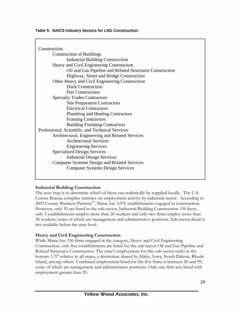
Yellow Wood Associates, Inc.
29
Table 5: NAICS Industry Sectors for LNG Construction.
Industrial Building Construction The next step is to determine which of these can realistically be supplied locally. The U.S. Census Bureau compiles statistics on employment activity by industrial sector. According to 2003 County Business Patterns69, Maine has 5,076 establishments engaged in construction. However, only 10 are listed in the sub-sector, Industrial Building Construction. Of these, only 3 establishments employ more than 20 workers and only two firms employ more than 50 workers, some of which are management and administrative positions. Sub-sector detail is not available below the state level. Heavy and Civil Engineering Construction While Maine has 336 firms engaged in the category, Heavy and Civil Engineering Construction, only five establishments are listed for the sub-sector Oil and Gas Pipeline and Related Structures Construction. The state’s employment for this sub-sector ranks in the bottom 1/5th relative to all states, a distinction shared by Idaho, Iowa, North Dakota, Rhode Island, among others. Combined employment listed for the five firms is between 20 and 99, some of which are management and administrative positions. Only one firm was listed with employment greater than 20.
Construction
Construction of Buildings Industrial Building Construction
Heavy and Civil Engineering Construction Oil and Gas Pipeline and Related Structures Construction
Highway, Street and Bridge Construction Other Heavy and Civil Engineering Construction
Dock Construction Pier Construction
Specialty Trades Contractors Site Preparation Contractors Electrical Contractors Plumbing and Heating Contractors Framing Contractors Building Finishing Contractors Professional, Scientific, and Technical Services Architectural, Engineering and Related Services Architectural Services Engineering Services Specialized Design Services Industrial Design Services Computer Systems Design and Related Services Computer Systems Design Services

Yellow Wood Associates, Inc.
30
Other Heavy and Civil Engineering Construction Under the NAICS system, firms engaged in dock and pier construction would fall under the classification, Other Heavy and Civil Engineering Construction. In all of Maine, there are 56 establishments listed in this sub-sector. The majority of these establishments employ fewer than five workers and only six firms employ between 20 and 49 workers. Greater sub-sector detail is not published; therefore, with Census data, one cannot distinguish between firms which engage in shoreline protection or port facility construction versus dock and pier construction. Furthermore, data are not available at the county or local level. Because Census data for the sub-sectors most relevant to LNG terminal construction are not reported below the state level, it is not possible to say whether any of these firms are located within the study area or, for that matter, in Washington County. Nevertheless, statewide figures suggest the specialized expertise that is required for LNG terminal construction is not particularly abundant in Maine. Survey of State, Regional and Local Firms An interview with the Associated Constructors of Maine yielded a list of eight firms engaged in large-scale Heavy and Civil Engineering Construction in Maine. These firms offices are primarily located in and around the Augusta, Portland and Bangor metropolitan areas, as might be expected. A sample of 50 past and current projects typically included box stores, schools, parking garages, roads, and landfills with an average project total of $1.7 million. The largest project in the sample was $9 million. The survey did identify one firm that listed dock and oil drilling rig construction among its past projects; however; LNG terminal construction was not reported. The larger project totals cited by this firm were in the $70 to $150 million range. Specialty Trade Contractors The analysis of Census data for firms engaged in the construction of what will be the major components of an LNG terminal suggests little potential for significant construction spending at the state level and, by inference, less at the regional and local levels. However, there may be greater potential for involvement by firms engaged in specialty trades. The most likely role for local and regional firms would be as subcontractors providing electricity, plumbing and heating to support buildings and warehouses or in access or interior road construction or site preparation. Onshore Terminal Capital Expenditures The question now becomes: What proportion of the total project expenditures is captured by each project component? To estimate LNG impacts to Louisiana, Moroney et.al.70 created a generic model of an onshore LNG terminal and associated capital expenditures. Using this study makes possible the identification of the capital intensive components of a terminal. According to the authors, over 60 percent of construction costs can be attributed to the storage tanks, unloading and processing equipment, and engineering and management; capacities which, based on the analysis to this point, do not appear to be in great supply in the state let alone the local area. Adding another 28 percent for a dock and pipeline covers just about 90 percent of construction costs.
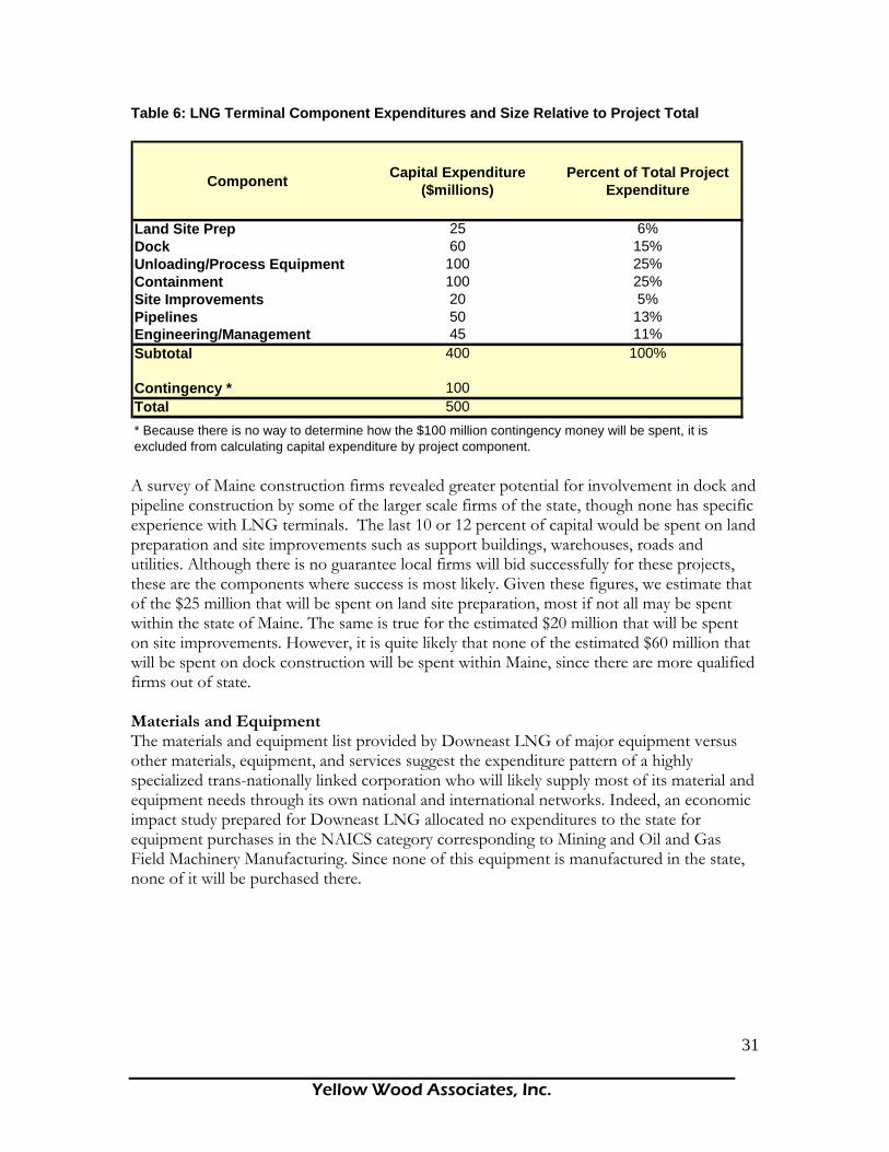
Yellow Wood Associates, Inc.
31
Table 6: LNG Terminal Component Expenditures and Size Relative to Project Total
Component Capital Expenditure ($millions)
Percent of Total Project Expenditure
Land Site Prep 25 6%Dock 60 15%Unloading/Process Equipment 100 25%Containment 100 25%Site Improvements 20 5%Pipelines 50 13%Engineering/Management 45 11%Subtotal 400 100%
Contingency * 100Total 500* Because there is no way to determine how the $100 million contingency money will be spent, it is excluded from calculating capital expenditure by project component. A survey of Maine construction firms revealed greater potential for involvement in dock and pipeline construction by some of the larger scale firms of the state, though none has specific experience with LNG terminals. The last 10 or 12 percent of capital would be spent on land preparation and site improvements such as support buildings, warehouses, roads and utilities. Although there is no guarantee local firms will bid successfully for these projects, these are the components where success is most likely. Given these figures, we estimate that of the $25 million that will be spent on land site preparation, most if not all may be spent within the state of Maine. The same is true for the estimated $20 million that will be spent on site improvements. However, it is quite likely that none of the estimated $60 million that will be spent on dock construction will be spent within Maine, since there are more qualified firms out of state. Materials and Equipment The materials and equipment list provided by Downeast LNG of major equipment versus other materials, equipment, and services suggest the expenditure pattern of a highly specialized trans-nationally linked corporation who will likely supply most of its material and equipment needs through its own national and international networks. Indeed, an economic impact study prepared for Downeast LNG allocated no expenditures to the state for equipment purchases in the NAICS category corresponding to Mining and Oil and Gas Field Machinery Manufacturing. Since none of this equipment is manufactured in the state, none of it will be purchased there.

Yellow Wood Associates, Inc.
32
Table 7: Equipment List
Major Equipment Shop Fabricated Storage Tanks API 618 Boil-Off Gas Holding Compressor Plate and Frame Heat Exchangers Cryogenic Pumps Distributed Control Systems Gas Metering System Gaseous N2 Generation Package Liquid N2 Generation Package Process Heating Equipment Shell and Tube Exchangers Dry Chemical System Ultrasonic Flow Meters Control Valves
Analyzer Shelter Equipment On/Off Butterfly and Ball Valves Safety Instrumented System Fire and Gas Detection Panels Structural Steel Fabrication Vertical Pump (Sea Water) Fresh Water Fire Pumps Sea Water Fire Pumps Jockey Pumps Fire Protection Equipment Emergency Diesel Generator SS Drums CS Drums
Other Materials, Equipment, and Services Air Charters Air Supply Piping, Manifolds Anchor Bolts Blanks and Spacers Building Plumbing Building Wiring Cable Car and Truck Rental Services Catering Services Concrete Cryogenic Related Valving Dump Truck Service Electrical Bulk Supplies Fencing Filters Flanges and Fittings Flexible Hose Flow Meters Food Supply Freight Delivery Services Fuel Gaskets and Studs Gates General Consumable Supplies
Grouting Material and Supplies Heavy Equipment, Cranes, Forklifts Housekeeping Services and Tools HVAC Systems for Buildings Hydraulic Hose and Repair Service Industrial Hand Tools Industrial Thermometers Inspection Services Instrumentation Tubing Instrumentation Wiring Insulation Level Gauges and Switches Light Fixtures Limit Switches Lodging Office Equipment Portable Generators Power Poles Rebar Stainless Steel Fittings Transformers Utility Trailers and Rentals Welding Supplies and Equipment Wire Mesh for Concrete Work
Source: Downeast LNG. Employment Commitment and Procurement Strategy Without knowing who will apply, who will win the bids, etc., it is difficult to put a number on the direct economic impact from construction, let alone indirect effects. Whether construction workers commute, relocate temporarily or already reside in the study area makes all the difference, especially with respect to indirect impacts because the spending

Yellow Wood Associates, Inc.
33
patterns of workers that are financed by their employment in construction are greatly determined by their residency status. Downeast LNG estimates 80 percent, or 240 construction jobs, can be filled by Maine residents and that it is possible that the remaining 20 percent of positions for “highly skilled trades people, engineers and supervisions crews with experience construction LNG tanks, cryogenic technology and related facilities could also be filled by Maine residents.” 71 Downeast LNG’s commitment to local hiring, worker training and local materials procurement is commendable. The economic benefit to the host community is dependent on these spending patterns. But, after approval is granted, the manager of a $500 million project must procure essential labor and supplies from wherever they are available. In turn, the reliability of estimated local impacts will be determined by the extent to which a firm’s intentions can be realistically met. What Others Have Said In a 2004 report at a public symposium on LNG, the Maine State Planning Office estimated 90 percent of construction jobs would come from Maine. Another report prepared for Downeast LNG by the Margaret Chase Smith Center for Public Policy at the University of Maine estimated domestic expenditures for construction of the pier, storage tank, pipelines and site improvements. Using a shift share technique, they estimate that 72 percent of expenditures in these categories will be made within the State of Maine. The shift share technique estimates local impacts by comparing a ratio of relevant employment in the study area to the national average. If local employment in that industry is below the national average, say 72 percent, then it is anticipated that 72 percent (rather than 100 percent) of total construction expenditures will be made within the study area. For this analysis, the study area is the state rather than a more local area as defined by the Machias and Calais Labor Market Areas, for example. By this rationale, $360 million of a $500 million project would be spent in Maine. While the shift share method with its specific numerical estimate is enticing, it uses the very same Census data (with all its geographical and sub-sector limitations) discussed in the preceding paragraphs. Therefore, rather than illuminating realistic impacts, in this case it tends to obscure them, because it fails to address the high degree of specialization in machinery, equipment materials, skills and experience needed to construct an LNG terminal. Interestingly, this same study cited another report prepared by the Tulane-Entergy Energy Institute which estimated the impacts to the Louisiana economy of eight projects to increase its LNG import capacity. That study used an aggregate domestic spending figure of 63% for a state that has an existing import capacity of 230 billion cubic feet per year and whose Gross State Product in petroleum and natural gas extraction and refining dwarfs that of Maine (table 8).

Yellow Wood Associates, Inc.
34
Table 8: Comparisons of 1990 Total Gross State Product (GSP), and GSP in the Oil and Gas Industry
Oil & Gas GSP ($) Oil & Gas GSP as Percent of Total GSP Total GSP ($)
Maine 2 mil 0% 23 bilLousianna 1.4 bil 1.60% 92 bilTexas 29.5 bil 7.22% 382 bil (USDA Forest Service, 1996) Dominion, a firm which operates a facility at Cove Point Maryland, also has proposed a $550 million expansion project. This project includes two additional storage tanks and 47 miles of distribution pipeline within Maryland. A study prepared for Dominion by RESI72 research and consulting reveals not only the division of construction capital between materials and labor but also the location from where material and labor is most likely to be procured. The study concluded that 97 percent of the materials necessary for plant construction would be procured outside of Maryland. The figure for pipeline construction materials was 50 percent. Furthermore, it reported 65 percent of plant construction workers and 66 percent of pipeline construction workers would come from out of state. Less than 20 percent of workers for both plant and pipeline construction would be current residents of the tri-county project area. Calvert County, in which the plant expansion is planned, has twice the population of Washington County, Maine, and the tri-county study area (which excludes the District of Columbia) of the RESI report listed a 2000 population of nearly 1 million, almost equal to the entire population of Maine. The RESI report began by collecting accurate expenditure and employment data from Dominion. This step was identified as one of the most critical in its analysis because “the responses form the basis of the direct economic impacts and drive the multiplicative impacts.”73 It is reasonable to assume that the in-state fraction for LNG construction employment and materials procurement would be lower for Maine than for a state such as Louisiana, and that the fraction is dramatically reduced as the analysis zooms in on the locality. The figures for Washington County and ultimately the Calais and Machias Labor Market Areas must be a slim fraction of the 63% reported for Louisiana by the Moroney study. The most likely scenario is that the company building an LNG facility will turn to firms that already have experience and that the successful bid will come from a general contractor with plenty of experience in building petroleum import, refining or distribution facilities if not specifically LNG facilities. It will also most likely be a firm with huge financial resources and an international network of suppliers. For example, CB&I, a firm that employs 10,000 people in offices around the world with projects in Thailand, South Africa, Nigeria, Virginia, Texas, Venezuela, and Shanghai landed over $1 billion in LNG contracts in 2004-2005 alone. Bechtel’s Project Director for the Sabine Pass LNG project said that while the company is willing to hire local contractors,

Yellow Wood Associates, Inc.
35
they must have experience or understand LNG and/or petrochemical construction. Bechtel will occasionally hire non-skilled workers and then train them, but for the most part they must have had prior experience. The subcontracting firms Bechtel does hire are also primarily large in scale. Bechtel will hire local subcontractors for general needs such as utilities, roads and site preparation, but much of the expense is in the storage tanks; this work is highly technical and requires specialized expertise74. Of all the studies cited in the current report, the independent RESI study was most specifically targeted to realistic estimates of local impacts and relied on data provided by the developer. Furthermore, figures used in the RESI study appear most compatible for use in the Passamaquoddy Bay area due to the relative similarity of Calvert County, Maryland (in which the Dominion expansion is planned), and Washington County, Maine. There are differences between the two. Calvert County has twice the population of Washington County and the tri-county study area of the RESI report (which excludes the District of Columbia) listed a 2000 population of nearly 1 million, almost equal to the entire population of Maine. Furthermore, the Maryland project is an expansion of an existing facility and thus it can be presumed that a greater supply of the essential skills and experience is locally available. Given these differences, Maine impacts may be overstated by using the RESI figures.75 Tables 9 and 10 anticipate state, regional and local level direct impacts of a generic LNG import terminal on the east coast of Maine. It assumes a project total of $400 million (excluding the $100 million contingency) and based on RESI data allocates 58 percent or $232 million for materials and 42 percent or $168 million for labor. Next, the Moroney estimates of capital expenditure by component are applied to the labor and materials categories. If 25 percent of a facility’s cost is in storage tanks, then it was assumed 25 percent of the total for both materials and labor were required to build this component. Finally, the table geographically distributes component expenditures based on modifications to the RESI study. Table 9: Materials proportioned by construction component and geographically distributed as estimated for a Passamaquoddy Bay LNG terminal. Plant Construction
Out State In State Regional Local
ComponentProportion of Total 1
Spending by Component
97% 2.0% 1.0% 0.0%
Containment 25.00% $58,000,000 $56,260,000 $1,160,000 $580,000 $0Unloading Processing Equipment 25.00% $58,000,000 $56,260,000 $1,160,000 $580,000 $0Engineering/Management 11.00% $25,520,000 $24,754,400 $510,400 $255,200 $0Land Site Prep 6.00% $13,920,000 $13,502,400 $278,400 $139,200 $0Site Improvements 5.00% $11,600,000 $11,252,000 $232,000 $116,000 $0
Out State In State Regional Local50% 35% 10% 5%
Pipeline 13.00% $30,160,000 $15,080,000 $10,556,000 $3,016,000 $1,508,000Dock 15.00% $34,800,000 $17,400,000 $12,180,000 $3,480,000 $1,740,000Subtotal 100.00% $232,000,000 $194,508,800 $26,076,800 $8,166,400 $3,248,000
1. Source RESI, 2004.2. Source Moroney, et.al., 2004.
Materials Expenditure Distribution 2

Yellow Wood Associates, Inc.
36
The above table shows that $194,508,800 of materials, or 84 percent, are likely to be procured out of state. An estimated $26 million may be spent on materials in-state and as much as $8.2 million may be spent within Washington County. It is estimated that $3.2 million may be spent locally. The table below shows the estimated allocation between out-of-state, in-state, region and locality of labor for plant construction. Table 10: Plant construction labor and expenditures Plant Construction
Out State 3 In State 3 Regional Local
ComponentProportion of Total 1
Spending by Component 79% 21.0% 0.0% 0.0%
Containment 25.00% $42,000,000 $33,180,000 $8,820,000 $0 $0Unloading Processing Equipment 25.00% $42,000,000 $33,180,000 $8,820,000 $0 $0Engineering/Management 11.00% $18,480,000 $14,599,200 $3,880,800 $0 $0
Out State In State Regional Local66% 17.0% 14.0% 3.0%
Pipeline 13.00% $21,840,000 $14,414,400 $3,712,800 $3,057,600 $655,200Dock 15.00% $25,200,000 $16,632,000 $4,284,000 $3,528,000 $756,000
Out State In State Regional 4 Local 4
0% 0% 90% 10%Land Site Prep 6.00% $10,080,000 $0 $0 $9,072,000 $1,008,000Site Improvements 5.00% $8,400,000 $0 $0 $7,560,000 $840,000Subtotal 100.00% $168,000,000 $112,005,600 $29,517,600 $23,217,601 $3,259,200
Materials and Labor Total $400,000,000 $306,514,400 $55,594,400 $31,384,001 $6,507,200Contingency $100,000,000Total $500,000,000
1. Source RESI, 2004.2. Source Moroney, et.al., 2004.
Labor Expenditure Distribution 2
The above table shows that $112 million will be spent to bring construction workers in from out of state. An estimated $29.5 million will be spent on workers in state but outside the region, another $23.2 million on workers within Washington County but outside the study region, and an estimated $3.3 million on workers within the study region. These estimates describe total expenditures over an approximate three year period. Therefore, if local workers’ salaries and benefits average $40,000 per year, each LNG terminal is estimated to provide approximately 27 jobs per year to current residents of the study region during the construction phase. Industry Characterization LNG Terminal Operation Local impact resulting from plant operations is likely to occur much as it will for plant construction. Many of the required personnel skills will be recruited from outside the study area, especially for the management, scientific and technical positions. While these jobs will command salaries in excess of $100,000, the jobs most likely within reach of local residents will be more in line with existing pay scales of the region.

Yellow Wood Associates, Inc.
37
The following is a list of job titles for plant operations provided by Downeast LNG.76
1. Plant Manager 2. Environmental Manager 3. Operations Manager 4. Health and Safety Manager 5. Marine Safety Officer 6. Maintenance Manager 7. Plant Chemist 8. Materials Coordinator 9. Electrical, Control and Instrumentation Engineer 10. Mechanical Engineer 11. Environmental Assistant-Water/Land 12. Environmental Assistant-Air Quality 13. Shift Supervisor 14. Operator Technicians 15. Human Resource Manager 16. Plant Accountant 17. Warehouse Clerk 18. Electrical Technicians 19. Control and Instrumentation Technician 20. C&I Maintenance Contractors 21. Electrical Maintenance Contractor 22. Mechanical Maintenance Contractors 23. Mechanical Technician 24. Site Security Personnel 25. Administrative Assistant
Many of the required personnel skills will be recruited from outside the study area, especially for the management, scientific and technical positions. The following is an example of two positions advertised by one recruitment service website (International Staffing Consultants Inc. http://www.iscworld.com/construction_job_openings.htm) for the LNG industry showing the experience, educational background and salary level associated with LNG professionals. There is an international labor pool for these positions. LNG TANK ENGINEER Houston, Texas $110000 + $50% bonus* Exciting Houston based energy operating company owning and building LNG (liquefied natural gas) receiving plants on the Gulf Coast seeks: LNG TANK ENGINEER. The PTank Engineer will provide E&C oversight and Operations support to the LNG Plant Project during the design, construction, startup, commissioning and plant operations of the project. Need: • 15 years experience as a Mechanical Engineer with a tank design background within the LNG industry. • Certified Welding Inspector, API and Asnt or AWS Certification in good standing. Experienced in Regulations such as: NFPA 59A 2001 ed., API 620, ANSI B31.3, API 1104, AWS, 49CFR Parts 192 & 193, and NDT and welding standards. • Experience in the design, operation and maintenance of equipment and systems within in LNG facility and working knowledge of plant maintenance systems. • Excellent computer skills including a working knowledge of simulation applications • RPE License *NOTE: BASE SALARY ABOVE IS MIDPOINT; BUT THIS COMPANY PAYS A 50% BONUS AND GIVES AN OPTION ON 4000 SHARES OF STOCK. And in 2 years their stock has GONE UP 10X and should go through the ceiling when they start receiving LNG from overseas. They are about the only LNG operator who has secured the numerous permits to build their plants in Corpus, Freeport, Sabine Lake and should receive the Calcasieu permits in Dec.

Yellow Wood Associates, Inc.
38
Marine Terminal Manager Calcasieu (S. of Lake Chas), Louisiana $110000 + $50% bonus* Exciting Houston based energy operating company owning and building LNG (liquefied natural gas) receiving plants on the Gulf Coast seeks: MARINE TERMINAL MANAGER for their to-be-build Calcasieu, LA gasifier plant. WILL HEAD THE LNG TERMINAL TO PROVIDE DAILY MANAGEMENT OF MARINE OPERATIONS; PROVIDE CO. CONTROLS TO SAFE WORK OF LNG SHIPPING, ADHERENCE TO APPROVED POLICIES AND GOVERNMENT REGS, SHIPPING SKEDS AND BUDGETS. Need: • 15 years working in a port engineering and management of marine activities, with strong supervisory skills • Although experience w/ LNG is preferred, Crude Oil or Petrochemical terminal management if fine • A ship master's certificate and experience on board international or Gulf Coast tankers is strongly desired. • A high level of safety awareness and knowledge of applicable coast guard and marine design regulations, including LNG • Knowledge of design, operation and maintenance of equipment and systems within a crude, LNG or petrochemical marine facility. While these jobs command salaries in excess of $100,000, the jobs most likely within reach of local residents will be more in line with existing pay scales of the region. In general, the educational attainment of the population in the Washington County portion of the study area matches that of Washington County as a whole and is somewhat lower than for the State of Maine. For example, only 4.7% of those over 25 in the study area have graduate or professional degrees compared with 5.1% in Washington County and 7.9% statewide. Approximately 14% of the study area population has a 9th to 12th grade education with no diploma, compared with 13% for Washington County and 9% statewide. A similar pattern holds in the Canadian portion of the study area. Educational attainment in study area communities is quite similar to that for Charlotte County as a whole and a bit behind the Province of New Brunswick. The notable exception is Saint Andrews Town in which fully 41% of the population has a university degree, certificate or diploma compared with 13% in the study area overall. By and large, local employment opportunities will come from those few positions that relate to the function of any business enterprise: administration, personnel, security and maintenance. Clearly, if the average salary as reported by Downeast LNG is $60,000, and LNG professionals command $100,000 or more, there must be jobs in the $20,000-$30,000 range to support the average. Based on their experience, dominant skill sets, and educational attainment, these are the jobs for which local residents will be eligible. With benefits, these positions might pay in the range of $30,000 to $40,000.
Multipliers
To understand the impact of significant change in the economy; an assessment of the direct effects is but a first step. Knowing both the magnitude and geographic distribution of first round expenditures is key. After this, the interdependence of various sectors of the economy and between businesses becomes the concerning issue. The local construction industry, for example, is linked to both local as well as higher levels of economic organization. With increased demand for its services, as might be the case were an LNG facility to be built, it will require higher levels of goods and services from its suppliers and they from theirs. These subsequent rounds of spending represent the multiplier, or indirect, effect that is the economy’s response to an initial increase in demand for construction, the direct effect.
Yellow Wood Associates, Inc.
39
There are differences, both in the degree of interconnectedness from industry to industry and from region to region, in which the source for necessary supplies is the central factor. Large multipliers suggest a high level of local integration and a strong local capacity to capture successive rounds of spending. However, our analysis of proposed LNG projects in Maine strongly suggests that not only are first round direct effects most often overestimated but indirect effects are also exaggerated. Supply Chains Like the federal facility studied in the Dumas report,77 the supply chains for companies operating LNG facilities and for the construction companies who build them will largely bypass local, regional and state economies. Both the Margaret Chase Smith (MCS) Policy Center and Downeast LNG78 make use of multipliers for their studies. The former used the IMPLAN model; the latter uses the Maine Regional Output Simulation Model. Multipliers represent a snapshot of the relationships between the study area’s industries at the time the model was constructed. Since Maine does not have an active LNG construction industry, no prepackaged model can provide an accurate picture of the new supply chain that will emerge to meet the temporary increase in demand for construction services and the industries that will supply them. Because it is based on current patterns, any direct impact fed into such a model assumes the existing supply chain is called into action. If existing heavy and civil engineering firms have built mostly box stores and parking garages, then feeding a direct impact of $74 million per year into the model is equivalent to asking what the impact would be to Maine if its construction firms were asked to build $74 million in box stores every year for three years. Direct and Indirect Effects Estimation One problem with multipliers is that mistakes are also multiplied. MCS uses NAICS employment data to estimate the direct effects of LNG construction for state and regional levels. Thus, a $500 million project would deliver $360 million (72 percent) to Maine over three years. Washington County would realize 56 percent or $280 million. However, the location quotients used to make these estimates of direct effects are hampered by a lack of specificity, a point they acknowledge with respect to county level estimates. In reality, both the state and county level location quotients are suspect. Because Maine has 72 percent of the national average for the broad category, Architecture and Engineering Services, it does not necessarily follow that 72 percent of the spending in this category will be blessed upon those firms. There are many types of architects and they apply their skills to different kinds of projects. Those who design luxury homes will not be asked to design an industrial plant; yet they are among the firms used in calculating the quotient. The same is true for Heavy and Civil Engineering but, while they fit the category, our survey found no Maine firm has ever built an LNG facility. To assume state and regional expenditures based on this analysis ignores the complex realities of highly technical industrial construction. The estimates for the direct effects on employment also deserve cautionary treatment. MCS uses NAICS employment numbers to estimate Maine construction expenditures which, when fed to IMPLAN, yield total labor income. Total income is then divided by Department of Labor average wage data to give the number of employees. From estimates of construction expenditures come estimates of construction employment; the result, 370 jobs, is 154% greater than that estimated by the company, 240, for which the report was

Yellow Wood Associates, Inc.
40
prepared. If estimates of direct effects, local construction spending and job creation are inflated, then the indirect effects which are supposed to flow from them become useless. The following table shows the direct, indirect and total effects on construction employment estimated by Downeast LNG and MCS. Table 11. Direct, Indirect, Total Effects of Maine Construction Employment.
Construction Phase Direct EffectsIndirect Effects Total Effects
Report Author Maine Employment
Expenditure millions
Maine Employment
Expenditure millions
Maine Employment
Expenditure millions
Downeast LNGEmployment and Payroll 240 $15.2 1620 $38.4 1860 $53.6
MCS Policy CenterEmployment and Payroll 370 $24.1 596 $15.6 966 $39.7 The figures pulled from these two reports are construction employment estimates for the same project and illustrate significant variance in the level of direct effects. When direct effects are plugged into their models, the MCS study produces a construction employment multiplier of 2.61. That same multiplier for the Maine Regional Output Simulation Model utilized by Downeast LNG was 7.75. Models such as these can provide useful measures of economic impact provided certain assumptions hold:
1) The direct effects of construction labor and materials purchases are accurately determined for the study area,
2) The direct effects of operations labor and materials purchases are accurately determined for the study area,
3) There is an infinite supply of inputs (labor and materials), 4) The interdependencies in the economy are not changing; the geographic distribution
of purchases is predetermined.
These assumptions must be met before confidence in the output of these models is justified. This report contends they have not been met. In concluding this section, the cautionary words that frequently accompany impact analysis reports may be instructive.
“Multipliers should be interpreted with care and discretion. Even slight differences in the manner in which a multiplier is applied can greatly influence the magnitude of predicted economic impact. As noted, a large multiplier generally indicates that an industry is closely linked to the local economy. However, if the industry is small relative to the size of the local economy, then a big multiplier does not translate into a large stimulus. On the other hand, a small increase in demand for a sector with a small multiplier can have a significant impact if that industry produces a large proportion of total output of the regional economy.

Yellow Wood Associates, Inc.
41
The size of a multiplier is usually indicative of how intermediate demand within the economic region will be stimulated by a change in final sales. Generally, if a sector has a large multiplier, then it is well connected with local firms. This suggests that an increase in sales to final demand will have a strong positive impact on the local economy. Conversely, a small multiplier indicates that few needed inputs are available from local firms. If this were the case, an increase in final demand for products of that sector would have little economic impact locally. This relationship does not always hold, however. Even if a particular input is available locally, buyers may still import it from elsewhere for a variety of reasons. These individual decisions are somewhat captured by the regional purchase coefficients (RPCs) embedded in the IMPLAN model, but they should be addressed carefully in impact analyses.” 79
In summary, we anticipate that of the estimated 40 full-time equivalent positions created at any one LNG terminal, an estimated 80% will require highly specialized training and will not be available to local workers. This leaves approximately 8 job openings for local people at a salary range likely to be similar to existing pay scales or slightly higher. In addition, there will be 12 jobs for tug boat operators during the operational stage. Some of these positions may be filled by local captains; however, piloting the type of tug boat used with LNG vessels requires specialized training. Therefore, in the short run at least, some of these jobs may go to trained operators.

Yellow Wood Associates, Inc.
42
Which economic activities that depend on land, air, or marine transportation are likely to be impacted by construction and operation of one or more LNG plants? The potential development of LNG facilities will directly impact transportation networks in the Passamaquoddy Bay region. The following section will outline the potential impacts in three main areas: land-based transportation (including vehicle traffic and bike routes), marine-based transportation, and air transportation. Land-Based Transportation: Vehicle Traffic If the development of one or more LNG facilities occurs, there will be a number of transportation-related impacts as a result of the specific phases associated with the project. Construction Phase Traffic directly related to construction of the facility and the pipeline is likely to consist of 118 heavy truck trips/month and 8 light truck trips/month. 80 For the pier construction, it is estimated that approximately 30 barge loads of materials will be delivered to the site during the construction phase. 81 However, it is unclear whether it will be possible to make shipments of construction materials by barge. If materials are delivered to the site entirely by truck and not by barge, the number of heavy trucks on the road could increase to 215 truck trips/month during the construction phase (approximately 36 months).82 During construction, the total volume of passenger trips may vary greatly, depending on the average occupancy per vehicle and the passenger’s point of origin, but may be as many as 600 trips per day (18,000 trips/month).83 LNG Transport by Truck The various proposals, as described to date, do not involve transporting LNG from the facility by truck. There are at least two circumstances under which this fact might change. One scenario is if there were to be a real or perceived problem with the natural gas pipeline. Real problems could be caused by an operator, a construction error, corrosion, or damage by outside forces.84 Perceived problems could be caused by a malfunction in sophisticated mechanisms used to detect pipeline failure and/or sensors to detect leaks.85 Should there be a perceived or real problem with the pipeline, distribution of incoming LNG may need to occur by truck.86 LNG trailers typically carry around 11,000 gallons each. It will take many trailers to transport even a small fraction of the LNG coming into Passamaquoddy Bay. If a load were to arrive when the storage tanks were full, one way to handle the situation would be to offload to trucks. Tankers must offload their cargo within a certain period of time, since a percentage of the extremely cold liquid burns off each day, making long hauls at sea unprofitable.87 The second situation in which LNG might be transported through Passamaquoddy Bay communities by truck would be if the plant operators were to expand into the growing niche market for LNG as a vehicular fuel. The demand in this market is typically met by truck deliveries.88

Yellow Wood Associates, Inc.
43
Operation Phase-Related Traffic Given that there will be approximately 40 permanent staff positions at any one LNG site during its operational phase and that at least some of these positions are likely to be filled by people who choose to live locally, the associated traffic impacts are not likely to be significant. Impacts associated with both the construction phase and LNG transport by truck will be addressed in the sections below. Geographic Range of Impacts The potential LNG developments are to be located in an area along the waterfront from Devil’s Head to Split Rock. Two of the three developments are likely to have direct access to Route 1, while the third is located approximately 2.2 miles off of Route 1 on State Road 190. Much of the traffic associated with all three developments (i.e. construction vehicles) is likely to occur between the sites and Route 9, which is a principal arterial connecting the region to other parts of the state.89 Route 1 south of Route 190 is likely to carry some of the commuter traffic associated with the construction of the facility. For the purposes of this report, we will be focusing on potential impacts to the 37.4 mile section of Route 1 from Route 9 to Dennysville. Types of Impacts Land-based transportation impacts include impacts to the infrastructure itself (deterioration of road surface), traffic impacts, and fiscal impacts associated with road maintenance/repair. Each of these impacts is discussed below. Traffic Impacts Types of traffic along this section of Route 1 include commuter traffic, seasonal traffic (tourist), commercial traffic, and bike/pedestrian traffic. The Maine Department of Transportation (MeDOT) collects data on the quantity of traffic for all major roads in Maine. Total traffic volume is reported as Annual Average Daily Traffic (AADT) for each road segment, which includes all vehicles that pass a given point during a 24 hour period. In Map #10, the road segments for Washington County are displayed in different thicknesses, which correspond to the Annual Average Daily Traffic value (i.e. thicker segments correspond to higher AADT values). As is evident from this map, the section of Route 1 between Route 9 (north of Calais) and Dennysville is one of the major traffic corridors for Washington County. In fact, the average Annual Average Daily Traffic for this entire segment of Route 1 is 33% greater than the average Annual Average Daily Traffic for all of the state highways in Washington County combined. Traffic Characteristics The Maine Department of Transportation also collects data on the relative number of heavy trucks and passenger vehicles that comprise the Annual Average Daily Traffic for specific locations along Route 1. For this study, there are three state monitoring locations corresponding to each of the three potential LNG sites that will be useful in estimating the potential impact of LNG-related traffic.90

Yellow Wood Associates, Inc.
44
Construction-Related Traffic: Heavy Trucks In order to estimate the potential impact of the LNG construction-related activities on Route 1, Yellow Wood calculated the percent increase in total heavy truck traffic accruing from LNG trucks during the construction phase. We assumed that all materials were delivered by truck. As a result, we used the figure of 215 heavy trucks per month or about 7 truck trips per day.91 The following table displays the potential impacts to existing traffic flows along Route 1, as measured at three traffic monitoring locations between the Split Rock LNG site and Route 9.92 Table 12: Potential Impacts to Existing Traffic Flows
TRA
FFIC
CO
UN
T LO
CA
TIO
N
YEA
R
AA
DT
NU
MB
ER O
F H
EAVY
TR
UC
KS
(CLA
SS 4
-13)
%H
EAVY
TR
UC
KS
OF
AA
DT
NU
MB
ER O
F LN
G
TRU
CK
S (P
ER D
AY)
NU
MB
ER O
F H
EAVY
TR
UC
KS
(W/ L
NG
)
% IN
CR
EASE
IN
TRU
CK
TR
AFF
IC
SouthBoundCalais (West) 2004 9140 1170 12.80% 7 1177 0.6%Robbinston 2004 2730 220 8.06% 7 227 3.2%Perry 2004 2490 218 8.76% 7 225 3.2%
NorthBoundPerry (West) 2004 2460 241 9.80% 0 n/a n/a For each of the traffic monitoring stations, approximately 1 in every 10 vehicles is a heavy truck. Although the relative impact of adding 7 more truck trips per day is not great due to the large number of trucks already on the road (< 4% increase in total truck traffic), the total volume of heavy trucks mixing with passenger traffic is a potential concern in itself.93 If more than one LNG facility is constructed, the effects will be cumulative.94 The following table indicates the total impacts of all three LNG facilities on the same road segments.95 Note that the total number of trucks passing the Calais (West) station has tripled, while the number passing the Robbinston site has doubled. The additional 14 trucks at the Robbinston monitoring station represent an increase in truck traffic of 6.4%.
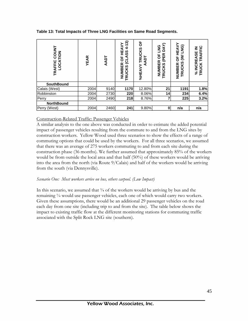
Yellow Wood Associates, Inc.
45
Table 13: Total Impacts of Three LNG Facilities on Same Road Segments.
TRA
FFIC
CO
UN
T LO
CA
TIO
N
YEA
R
AA
DT
NU
MB
ER O
F H
EAVY
TR
UC
KS
(CLA
SS 4
-13)
%H
EAVY
TR
UC
KS
OF
AA
DT
NU
MB
ER O
F LN
G
TRU
CK
S (P
ER D
AY)
NU
MB
ER O
F H
EAVY
TR
UC
KS
(W/ L
NG
)
% IN
CR
EASE
IN
TRU
CK
TR
AFF
IC
SouthBoundCalais (West) 2004 9140 1170 12.80% 21 1191 1.8%Robbinston 2004 2730 220 8.06% 14 234 6.4%Perry 2004 2490 218 8.76% 7 225 3.2%
NorthBoundPerry (West) 2004 2460 241 9.80% 0 n/a n/a Construction-Related Traffic: Passenger Vehicles A similar analysis to the one above was conducted in order to estimate the added potential impact of passenger vehicles resulting from the commute to and from the LNG sites by construction workers. Yellow Wood used three scenarios to show the effects of a range of commuting options that could be used by the workers. For all three scenarios, we assumed that there was an average of 275 workers commuting to and from each site during the construction phase (36 months). We further assumed that approximately 85% of the workers would be from outside the local area and that half (50%) of these workers would be arriving into the area from the north (via Route 9/Calais) and half of the workers would be arriving from the south (via Dennysville). Scenario One: Most workers arrive on bus, others carpool. (Low Impact) In this scenario, we assumed that ¾ of the workers would be arriving by bus and the remaining ¼ would use passenger vehicles, each one of which would carry two workers. Given these assumptions, there would be an additional 29 passenger vehicles on the road each day from one site (including trip to and from the site). The table below shows the impact to existing traffic flow at the different monitoring stations for commuting traffic associated with the Split Rock LNG site (southern).

Yellow Wood Associates, Inc.
46
Table 14: Impact to Existing Traffic Flow
TRA
FFIC
CO
UN
T LO
CA
TIO
N
YEA
R
AA
DT
NU
MB
ER O
F PA
SSEN
GER
VE
HIC
LES
(CLA
SS 1
-3)
% P
ASS
ENG
ER
VEH
ICLE
S O
F A
AD
T
# O
F LN
G-R
ELA
TED
PA
SSEN
GER
VE
HIC
LES
TOTA
L #
OF
PASS
ENG
ER
VEH
ICLE
S
% IN
CR
EASE
IN
PASS
ENG
ER T
RA
FFIC
SouthBoundCalais (West) 2004 9140 7970 87.20% 29 7999 0.37%Robbinston 2004 2730 2510 91.94% 29 2539 1.16%Perry 2004 2490 2272 91.24% 29 2301 1.28%
NorthBoundPerry (West) 2004 2460 2219 90.20% 29 2248 1.31% The percent increase in passenger traffic in column 8 is an indicator of the observable change in the quantity of traffic on that road. For example, if the percent change in passenger traffic is 100%, there is twice as much traffic on the road. This figure, however, is not related to the degree of congestion already on the road. Rather, those road segments that already have a high level of traffic will be impacted more by any additional traffic because these roads are already congested. We will discuss the level of congestion on these road segments in more detail on page 45, below. If all three LNG facilities are constructed during the same time period, there would be cumulative impacts to two of the three traffic monitoring stations above. These impacts are summarized in the table below. Table 15: Impact to Existing Traffic Flow for All Three Facilities
TRA
FFIC
CO
UN
T LO
CA
TIO
N
YEA
R
AA
DT
NU
MB
ER O
F PA
SSEN
GER
VE
HIC
LES
(CLA
SS 1
-3)
% P
ASS
ENG
ER
VEH
ICLE
S O
F A
AD
T
# O
F LN
G-R
ELA
TED
PA
SSEN
GER
VE
HIC
LES
TOTA
L #
OF
PASS
ENG
ER
VEH
ICLE
S
% IN
CR
EASE
IN
PASS
ENG
ER T
RA
FFIC
SouthBoundCalais (West) 2004 9140 7970 87.20% 87 8057 1.09%Robbinston 2004 2730 2510 91.94% 58 2568 2.31%Perry 2004 2490 2272 91.24% 29 2301 1.28%
NorthBoundPerry (West) 2004 2460 2219 90.20% 87 2306 3.92% Scenario Two: Most workers arrive by car (some carpooling), others take bus (Moderate Impact) In this scenario, we assumed that 1/3 of the workers would be arriving by bus and the remaining 2/3 would use passenger vehicles at an occupancy rate of 1.5 workers per vehicle.

Yellow Wood Associates, Inc.
47
Given these assumptions, there would be an additional 102 passenger vehicles on the road each day from one site (including trip to and from the site). Using the same analysis, the 102 vehicle trips will account for an additional 1.3% - 4.6% of passenger vehicle trips on Route 1, depending on the location. The cumulative impacts of all three sites will increase passenger vehicle trips on the same road segments from 3.8% to 14% (see Appendix C for calculations). Scenario Three: All workers drive their own car to and from work (High Impact) In this scenario, we assumed that all of the workers would drive their own car to and from work. Given these assumptions, there would be an additional 550 passenger vehicles on the road each day from one site (including trip to and from the site). The added 550 vehicle trips will account for an additional 2.9% - 10% of passenger vehicle trips on Route 1, depending on the location. The cumulative impacts of all three sites will increase passenger vehicle trips on the same road segments from 8.8% to 32%. By far the largest percentage increase in passenger traffic will occur on Route 1 southwest of Perry, which currently only handles approximately 2,460 vehicles per day (see Appendix C for calculations). Traffic Impacts Associated with LNG Transport by Truck Should there be a perceived or real problem with the lateral pipeline or the Maritimes and Northeast Pipeline, distribution of LNG may need to occur by truck. LNG tankers must offload their cargo within a certain period of time, since a percentage of the extremely cold liquid burns off each day, making long hauls at sea unprofitable.96 LNG trailer trucks typically carry around 11,000 gallons each. It would take over 3,000 truckloads of LNG to transport the 130,000 cubic meters. If it became necessary to transport an entire shipment (130,000 cubic meters) before the next tanker arrived at the site, the total volume of LNG trucks would be approximately 545 trucks per day.97 The potential impact of this volume of truck traffic on the existing roads is summarized in the following table. Table 16: Impacts Associated with LNG Transport by Truck
TRA
FFIC
CO
UN
T LO
CA
TIO
N
YEA
R
AA
DT
NU
MB
ER O
F H
EAVY
TR
UC
KS
(CLA
SS 4
-13)
%H
EAVY
TR
UC
KS
OF
AA
DT
NU
MB
ER O
F LN
G
TRU
CK
S (P
ER D
AY)
NU
MB
ER O
F H
EAVY
TR
UC
KS
(W/ L
NG
)
% IN
CR
EASE
IN
TRU
CK
TR
AFF
IC
% IN
CR
EASE
IN
TOTA
L TR
AFF
IC
SouthBoundCalais (West) 2004 9140 1170 12.80% 545 1715 46.6% 5.96%Robbinston 2004 2730 220 8.06% 545 765 248% 20.0%Perry 2004 2490 218 8.76% 545 763 250% 21.9%
NorthBoundPerry (West) 2004 2460 241 9.80% 0 n/a n/a n/a

Yellow Wood Associates, Inc.
48
This table indicates that the increase in LNG truck traffic associated with one shipment of LNG could more than double the existing truck traffic on Route 1 in the town of Perry, while accounting for almost 50% of the truck traffic in Calais. The increase in total traffic (passenger vehicles and trucks) would be significant for all three road segments. Level of Service (LOS) The level of service for a particular road segment is an indicator of traffic flow ranging from A (excellent) to F (failure). The level of service is typically calculated using methodology outlined in the Highway Capacity Manual.98 Using this manual, the MeDOT calculates the LOS for particular road segments from AADT figures in combination with physical characteristics of the road (i.e. two lanes).99 The Highway Capacity Manual defines the levels of service as follows:
• LOS A represents free flow. Individual users are virtually unaffected by the presence of others in the traffic stream. Freedom to select desired speeds and to maneuver within the traffic stream is extremely high. The general level of comfort and convenience provided to the motorist, passenger, or pedestrian is excellent.
• LOS B is in the range of stable flow, but the presence of other users in the traffic stream begins to be noticeable. Freedom to select desired speeds is relatively unaffected, but there is a slight decline in the freedom to maneuver within the traffic stream from LOS A. The level of comfort and convenience provided is somewhat less than at LOS A, because the presence of others in the traffic stream begins to affect individual behavior.
• LOS C is in the range of stable flow, but marks the beginning of the range of flow in which the operation of individual users becomes significantly affected by interactions with others in the traffic stream. The selection of speed is now affected by the presence of others, and maneuvering within the traffic stream requires substantial vigilance on the part of the user. The general level of comfort and convenience declines noticeably at this level.
• LOS D represents high-density, but stable, flow. Speed and freedom to maneuver are severely restricted, and the driver or pedestrian experiences a generally poor level of comfort and convenience. Small increases in traffic flow will generally cause operational problems at this level.
• LOS E represents operating conditions at or near the capacity level. All speeds are reduced to a low, but relatively uniform, value. Freedom to maneuver within the traffic stream is extremely difficult, and it is generally accomplished by forcing a vehicle or pedestrian to “give way” to accommodate such maneuvers. Comfort and convenience levels are extremely poor, and driver or pedestrian frustration is generally high. Operations at this level are usually unstable, because even small increases in flow or minor perturbations within the traffic stream will cause breakdowns.
• LOS F is used to define forced or breakdown flow. This condition exists wherever the amount of traffic approaching a point exceeds the amount which can traverse it

Yellow Wood Associates, Inc.
49
and queues begin to form. Operations within the queue are characterized by stopping and starting. Over and over, vehicles may progress at reasonable speeds for several hundred feet or more, then be required to stop. Level-of-service F is used to describe operating conditions within the queue, as well as the point of the breakdown. It should be noted, however, that in many cases once free of the queue, traffic may resume to normal conditions quite rapidly.
Upon request from Yellow Wood, MeDOT provided LOS ratings for Route 1 between Route 9 and Dennysville. Map #11 shows the segment of Route 1 color-coded to the level of service. The data from this map indicates that Route 1 from Dennysville until just south of the city of Calais is characterized by a stable flow of traffic (LOS B). As one passes through Calais on the way to Route 9, however, the level of service rapidly deteriorates. From just south of Calais to Route 9, there are 3.5 miles characterized as LOS C, 5.7 miles characterized as LOS D, and .13 miles of Route 1 that is rated with an LOS of E. Much of the traffic congestion associated with this stretch is due to the international border crossing between St. Stephen and Calais. This crossing is the 8th busiest border crossing between Canada and the United States. The congestion is primarily a result of over 900 trucks per day mixing with over 8,000 local and tourist passenger vehicles. In fact, the intersection of Main St. (Rte. 1) & N. St (Rte. 1) is one of Maine’s busiest intersections, with approximately 5.32 million vehicles entering the intersection in the year 2000. Congestion is likely to increase with construction of a third bridge connecting Calais and St. Stephen, regardless of LNG terminal construction and operation. The 2003 Calais Comprehensive Plan already acknowledges that emergency vehicles have difficulty responding to calls when traffic is heavy or backed up from both of the St. Stephen bridges. During the heavy tourist season, the Mill Town bridge in St. Stephen has traffic backed up for a considerable distance, requiring special signs and using the road’s gutter as a vehicle queue. 100 Impacts Safety While the added volume of traffic associated with the construction of the LNG facility or the trucking of LNG is not significant enough to further degrade the LOS for these segments on their own, there is a potential safety risk associated with the transportation of hazardous materials along this section. The intersection of Route 1 and Garfield Street in Calais has been identified as a high crash intersection by the Maine Department of Transportation in 2002.101 Shift in Traffic Volume The current congestion along Route 1, added to the potential for heavy truck traffic, may cause some truck drivers and passenger vehicles to seek alternate routes. In addition to increasing congestion, there may be financial impacts as a result of the deteriorating pavement condition along these alternative routes (see section below on funding sources for road improvements for an analysis of these impacts).
Yellow Wood Associates, Inc.
50
Emergency Evacuation from LNG Sites Under emergency situations, residents near an LNG facility may have to be evacuated from the region. Given the transportation network near the proposed LNG facilities, evacuees would use Route 1 in combination with other state and local roads. In the event of an emergency at the Split Rock site, safe evacuation of the residents of Eastport could be compromised because the main evacuation route away from the city, Route 190, lies within a few hundred feet of the LNG site itself. Rapid evacuation of Deer Island would be unlikely, as the ferry is the main mode of transport to and from the island. Evacuation of Campobello Island via the bridge to Lubec would be complicated by customs issues. Furthermore, if more than one LNG facility had an emergency situation that required evacuation, the safe egress of residents from the area could be significantly impacted. Road Condition According to a Report on Economic Development Strategy for Washington County, Route 1 from Ellsworth to Calais is in need of “substantial upgrading.”102 The Regional Transportation Advisory Committee Report (Region 3) also identifies Route 1 in eastern Washington County as “poor.” According to this same report, the poor condition of Route 1 is due in large part to heavy truck traffic. The heavy truck traffic is primarily due to freight shipments to and from the port of Eastport. The Maine Department of Transportation assigns pavement condition ratings for state highways such as Route 1. MeDOT uses this rating, in combination with the current and anticipated traffic, to prioritize when specific road segments are scheduled to receive improvements. Planned improvements to Route 1 are scheduled to take place between 2006 and 2009 and are estimated to cost $24 million.103 The LNG-related heavy truck traffic (i.e. construction traffic, LNG trucks) will undoubtedly hasten the deterioration of this segment of Route 1. Further deterioration of the condition of Route 1 could result in potential safety hazards to motorists, which may or may not cause the state to adjust the scheduled improvements. Regardless of when the improvements take place, construction on this segment may cause significant delays to residents and tourists alike. Costs of road maintenance will go up as use increases as well. Funding Source for Road Improvements There are three main categories of roads identified in Maine’s State Highway System.104 These include:
• State Highways: A system of connected main highways throughout the state which primarily serve arterial or through traffic. State Highways are mostly maintained by the state with some assistance from the federal government.
• State-Aid Highways (SA): Those highways not included in the system of the state highways which primarily serve as collector and feeder routes connecting local service roads to the arterial state highway system. Generally, State-Aid Highways in the rural area are maintained by MeDOT in the summer and by the town in the winter.

Yellow Wood Associates, Inc.
51
• Townways: All other highways not included in the state highways and state-aid highway systems, which are maintained by the towns and primarily serve as local service roads providing access to adjacent land.105
Financial Impacts to Passamaquoddy Bay Communities Based on the potential impacts of LNG-related transportation above, there may be scenarios in which there are financial impacts to the towns in the study area from construction and operation of one or more LNG import terminals. The section below discusses some of these scenarios. Direct Impacts: Route 1/Route 190 Route 1 and Route 190 are classified as state highways. As a result, funding for improvements to Route 1 comes primarily from the federal government, with some matching funds provided by the state government. Therefore, there are no costs associated with road improvements to Route 1 for the local municipalities. Indirect Impacts: Increased Truck Traffic on State-Aid Highways Due to the congestion on Route 1, some truck drivers may seek alternate routes to enter or leave the study area. Some of these alternate routes are State-Aid Highways. The maintenance for state-aid highways is shared between the local municipality and the state. For these roads, the municipality is only responsible for winter maintenance, which includes plowing and sanding. Since these types of maintenance activities would not be affected by increased truck traffic, there would likely be no additional costs for the municipality as a result. A subset of State-Aid Highways are designated as minor collectors according to the Federal Functional Classification System. Minor collectors are roads that provide service to smaller communities and link locally important traffic generators with the arterial system.106 Under the Maine Department of Transportation’s Urban/Rural Initiative Program, a town is responsible for 1/3 of the costs for capital improvements on State-Aid minor collector roads in town.107 Map #13 illustrates the roads in the study area that fall within this category. In order to bypass congestion on Route 1, these road segments may be used by both truck drivers and passenger vehicles as alternate routes, because of their location in relation to the LNG sites and other arterial connectors (Route 9). If these minor collectors are used as alternative routes, significant deterioration of the road surface will likely occur.108 As a result, the local communities’ expenses for road improvements may increase. Towns that may see increases in road improvement expenses include: Dennysville, Calais, Charlotte, Cooper, Alexander, and Baring Plantation. Indirect Impacts: Increased Truck Traffic on Townways Due to the congestion on Route 1, some passenger drivers may seek alternate routes to their destination. Many of the alternate trips will take place on townways, for which the local municipality is responsible for 100% of the funding. For example, in the Town of Perry for FY 2004-2005, the total road-related expenditures were $206,203. Shifting traffic volumes from state highways to townways will cause an increase in total road-related expenditures. If

Yellow Wood Associates, Inc.
52
there is a 10% increase in costs, the town of Perry would have to raise an additional $20,620. When combined with increased expenditures for nearby towns, the total cost to the region could be significant. Land-Based Transportation: Bicycle Traffic There are a number of existing bike tours that could be impacted by the increase in traffic and potential safety/security issues related to LNG traffic along Route 1. Bicycle Tour #24, Passamaquoddy Bay, is identified on the Maine Department of Transportation website and includes an alternate bike route that directly overlaps with the segment of Route 1 identified in this study. The bike route starts at the intersection of Gin Cove/Lake Road and Route 1 and proceeds north on Route 1, through Calais, and turns off of Route 1 at Charlotte Road. Additional heavy trucks and passenger cars associated with LNG development along this segment could further jeopardize the safety of bike riders, especially since there is no shoulder on this segment. Marine-Based Transportation Safety/Security of the Transit Route There are a number of potential navigational hazards associated with the transit of an LNG vessel from the Bay of Fundy to the three LNG sites.109 These hazards include: a restricted navigable waterway (the navigational channel is 700 yards at the narrowest), strong tidal currents, bad and unpredictable weather conditions, and the presence of other large marine vessels throughout the transit route. In order to assess the degree to which these hazards will affect actual navigation of the LNG vessels, Yellow Wood conducted a literature review on navigational safety issues and interviewed a number of marine pilots in the Passamaquoddy Bay region. The results of this research are summarized below. Pittston Study A 1976 communiqué released by the Department of External Affairs in Canada comments directly on the navigational safety of the proposed transit route. In response to an application by the Pittston Company to site an oil refinery at Eastport, Maine, the Canadian government released this communiqué which cited an earlier study by the Department of Fisheries and the Environment (Canada) that stated that the navigational passage through Head Harbour and Western Passage is “by far the least acceptable area for tanker operations, both because the value of the fisheries and aquatic bird resources in the region is so high and due to the high level of navigational risk associated with the passage.”110 According to a second study (also sited in this communiqué) which was prepared by the Department of Transport, entitled “Eastport Ship Terminal System: Accessibility and Ship Safety, Preliminary Analysis and Assessment” (1976), the approach through the passage toward Eastport is “winding,” the currents are “extremely difficult to judge” and “the weather conditions as yet cannot be controlled.”111 Although this communiqué was released over 30 years ago, it highlights some of the key factors associated with the large vessels navigating the above passages. These factors include
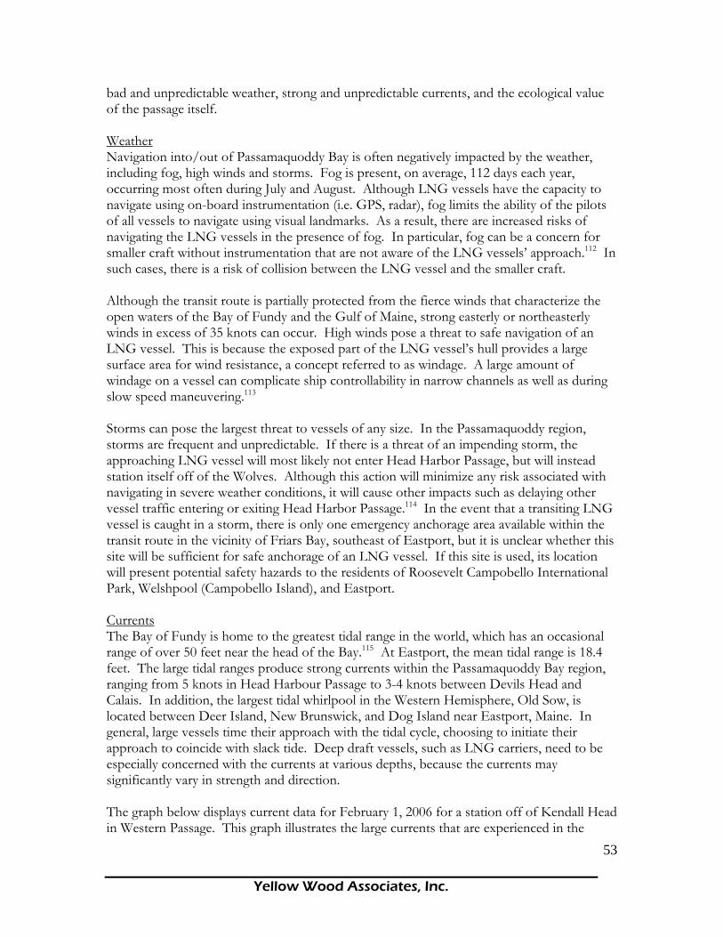
Yellow Wood Associates, Inc.
53
bad and unpredictable weather, strong and unpredictable currents, and the ecological value of the passage itself. Weather Navigation into/out of Passamaquoddy Bay is often negatively impacted by the weather, including fog, high winds and storms. Fog is present, on average, 112 days each year, occurring most often during July and August. Although LNG vessels have the capacity to navigate using on-board instrumentation (i.e. GPS, radar), fog limits the ability of the pilots of all vessels to navigate using visual landmarks. As a result, there are increased risks of navigating the LNG vessels in the presence of fog. In particular, fog can be a concern for smaller craft without instrumentation that are not aware of the LNG vessels’ approach.112 In such cases, there is a risk of collision between the LNG vessel and the smaller craft. Although the transit route is partially protected from the fierce winds that characterize the open waters of the Bay of Fundy and the Gulf of Maine, strong easterly or northeasterly winds in excess of 35 knots can occur. High winds pose a threat to safe navigation of an LNG vessel. This is because the exposed part of the LNG vessel’s hull provides a large surface area for wind resistance, a concept referred to as windage. A large amount of windage on a vessel can complicate ship controllability in narrow channels as well as during slow speed maneuvering.113 Storms can pose the largest threat to vessels of any size. In the Passamaquoddy region, storms are frequent and unpredictable. If there is a threat of an impending storm, the approaching LNG vessel will most likely not enter Head Harbor Passage, but will instead station itself off of the Wolves. Although this action will minimize any risk associated with navigating in severe weather conditions, it will cause other impacts such as delaying other vessel traffic entering or exiting Head Harbor Passage.114 In the event that a transiting LNG vessel is caught in a storm, there is only one emergency anchorage area available within the transit route in the vicinity of Friars Bay, southeast of Eastport, but it is unclear whether this site will be sufficient for safe anchorage of an LNG vessel. If this site is used, its location will present potential safety hazards to the residents of Roosevelt Campobello International Park, Welshpool (Campobello Island), and Eastport. Currents The Bay of Fundy is home to the greatest tidal range in the world, which has an occasional range of over 50 feet near the head of the Bay.115 At Eastport, the mean tidal range is 18.4 feet. The large tidal ranges produce strong currents within the Passamaquoddy Bay region, ranging from 5 knots in Head Harbour Passage to 3-4 knots between Devils Head and Calais. In addition, the largest tidal whirlpool in the Western Hemisphere, Old Sow, is located between Deer Island, New Brunswick, and Dog Island near Eastport, Maine. In general, large vessels time their approach with the tidal cycle, choosing to initiate their approach to coincide with slack tide. Deep draft vessels, such as LNG carriers, need to be especially concerned with the currents at various depths, because the currents may significantly vary in strength and direction. The graph below displays current data for February 1, 2006 for a station off of Kendall Head in Western Passage. This graph illustrates the large currents that are experienced in the
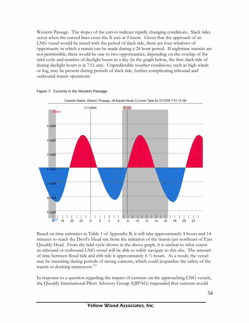
Yellow Wood Associates, Inc.
54
Western Passage. The slopes of the curves indicate rapidly changing conditions. Slack tides occur when the curved lines cross the X axis at 0 knots. Given that the approach of an LNG vessel would be timed with the period of slack tide, there are four windows of opportunity in which a transit can be made during a 24 hour period. If nighttime transits are not permissible, there would be one to two opportunities, depending on the overlap of the tidal cycle and number of daylight hours in a day (in the graph below, the first slack tide of during daylight hours is at 7:51 am). Unpredictable weather conditions, such as high winds or fog, may be present during periods of slack tide, further complicating inbound and outbound transit operations. Figure 7: Currents in the Western Passage
Based on time estimates in Table 1 of Appendix B, it will take approximately 4 hours and 14 minutes to reach the Devil’s Head site from the initiation of the transit just northeast of East Quoddy Head. From the tidal cycle shown in the above graph, it is unclear to what extent an inbound or outbound LNG vessel will be able to safely navigate to this site. The amount of time between flood tide and ebb tide is approximately 6 ½ hours. As a result, the vessel may be transiting during periods of strong currents, which could jeopardize the safety of the transit or docking maneuvers.116 In response to a question regarding the impact of currents on the approaching LNG vessels, the Quoddy International Pilots Advisory Group (QIPAG) responded that currents would
Yellow Wood Associates, Inc.
55
not significantly impact the safety of the voyage, given the approach would be timed with the period of slack tide.117 The Quoddy International Pilots Advisory Group is an international group of American and Canadian ship pilots that are recognized by both Coast Guard agencies in both countries. The Ecological Value of the Passamaquoddy Bay Region It should be pointed out that, with an increase in LNG-related vessel traffic, the probability of a marine accident (i.e. collision with land or other vessel) increases. However slight the probability, the increased risk should be weighed against the value of the ecological assets in the area. Although a thorough analysis of the value of the ecological assets of the area is beyond the scope of this report, the Passamaquoddy Bay region is known to be rich in biological resources. Key Informant Interviews Yellow Wood interviewed a number of active pilots in the Passamaquoddy Bay region in order to assess how the above conditions affect the overall safety of the LNG vessels. In December 2005, Yellow Wood submitted a list of questions to the Quoddy International Pilots Advisory Group related to the navigational safety of the proposed transit route.118 These questions covered issues such as the depth and width of the channel, the impact of currents, the role of tugs, and the pilots’ experience with navigating vessels over 700 feet in length. The Quoddy International Pilots Advisory Group’s response indicated that there were no significant risks associated with navigating vessels over 700 feet that would prohibit the development of LNG along the Maine coast. Yellow Wood spoke at length with Captain Gerald Morrison, who is a representative on the Quoddy International Pilots Advisory Group. On the subject of visibility, Morrison pointed out that, because of the ability to safely navigate the passage with instrumentation, an LNG vessel could make its approach in fog or during the night.119 Yellow Wood also spoke to Skip Rogers, General Manager of the Federal Marine Terminal of Eastport. The new port in Eastport opened in 1998 and can handle vessels up to 900 feet in length. In comparison, LNG tankers coming into the region are larger than all other vessels that would dock at Eastport. Rogers stated that, although there are strong currents near East Quoddy Head, the approach is navigable and poses no serious dangers to large vessels. Rogers claimed that, since 1981, there have been no major accidents for vessels approaching Eastport. Yellow Wood also contacted Charley Leppin, tug boat captain and the current harbormaster of Eastport. Leppin’s assessment was that the proposed transit was indeed navigable and did not pose serious dangers.
Yellow Wood Associates, Inc.
56
Safety Record of LNG Vessels As of 2004, there have been close to 80,000 transits of LNG tankers with no loss of LNG from the ships’ structure. There have been two serious incidents of LNG tankers striking ground (at 19 knots and 12 knots, respectively), but neither of these resulted in a containment loss. On September 19, 2005, strong winds slammed a tug boat into an LNG jetty in India. The tug boat was attempting to assist the LNG carrier, Disha, while it was casting off.120 With respect to minor incidents, such as small fires, leaks, or minor collision, the track record of LNG vessels is about average compared to other vessel types. However, due to their hazardous cargo, oil and liquefied gas vessels, including LNG, are potential targets of terrorist groups. Although there have been no terrorist attacks on LNG vessels within U.S. or Canadian waters to date, attacks abroad as wells as events at U.S. ports have caused the U.S. Coast Guard and the U.S. Department of Homeland Security to deal specifically with the issue. In July of 2003, pirates attacked and boarded an LPG (liquefied petroleum gas) tanker, a gas tanker and an oil tanker in Indonesia.121 In 2004, it was reported that “the Homeland Security Department has provided a chilling confirmation that individuals with possible terrorist connections may have entered the U.S. onboard LNG tankers that docked in Everett (MA)."122 Such threats of terrorist attacks have caused the U.S. Coast Guard to create permanent 1,000-yard radius security zones for liquefied natural gas (LNG) tankers within the Western Alaska Marine Inspection Zone and Captain of the Port Zone.123 Recent world events, such as the terrorist attacks in the U.S., England, and Spain, could signify increased danger to cargos of hazardous substances.124 Clearly, any increase in the transport and use of LNG will also increase the likelihood of accidents or attacks by some degree.125 In a motion of the Public Utilities Commission of the State of California to FERC regarding a proposed LNG terminal at the Port of Long Beach, a representative of the Commission argued for the denial of a permit for the LNG facility based on public safety concerns. Specifically, his testimony stated that “130,000 people living or working within three miles of the proposed site at the Port [of] Long Beach would be in harm’s way, and many of them could be killed or incur second-degree burns if there were a terrorist attack, earthquake or human error, which caused the release of LNG.”126 Impacts to Existing Marine Traffic There are many different types of marine traffic in the Passamaquoddy Bay region that have the potential to be impacted by LNG vessels, including: commercial traffic, ferry traffic, fishing boat traffic, recreational traffic, and research vessel traffic. Potential impacts to each of these groups are described below.
Yellow Wood Associates, Inc.
57
Commercial Traffic Key Informant Interviews Yellow Wood conducted a number of interviews with key personnel responsible for the major commercial ports in the region: Eastport, Maine and Bayside, New Brunswick. Eastport On average, there are 3-4 vessels a month that arrive in Eastport.127 Almost all of these vessels are cargo ships that are greater than 500 feet in length and have drafts of 25-35 feet. The shallowest approach from the Bay of Fundy to Eastport measures 68 feet at low tide, making it one of the deepest ports in North America. On occasion, when there is more than one large vessel leaving or approaching the ports of Eastport or Bayside, vessel traffic can be held up until the channel is clear.128 If one or more LNG developments were to occur, the probability and duration of delays to existing vessel traffic would increase in proportion to the number of LNG vessels entering the region. Bayside On average, there are approximately 70 vessels that visit the port of Bayside, New Brunswick every year. These vessels typically range from 255 – 656 feet in length, with the largest vessel measuring approximately 728 feet in length. David Seaman, Port Manager of Bayside, indicated that there may be impacts, due to LNG traffic, to the existing traffic to Bayside under certain circumstances. If the safety/security zones around the transiting LNG vessel prevented other vessels from exiting or approaching the port of Bayside, there may be significant impacts to the companies that use the port. Atlantic Coast Materials is one of the primary users of the port of Bayside.129 Michael Power, president of Atlantic Coast Materials and the Bayside Port Company, indicated that there was not enough information in the LNG proposals at this time to assess potential economic impacts on the port or on the users of the port. Seaman was also concerned about the potential impact of the proposed LNG terminal and pier at Red Beach, Calais. The width of the St. Croix River near the proposed Red Beach LNG site is one mile or less, while the distance from the U.S. shore to the international border line ranges from 1,700 – 2,640 feet (the navigational channel used by most large marine vessels from Western Passage to the St. Croix River follows the international border line). The pier for this site would need to be at least 1,100 ft from the shore in order to reach an appropriate depth of 42 feet for the LNG vessels. Given these measurements, there would be less than 1,100 feet between the navigation channel and the end of the pier (this does not include a safety/security zone that is likely to be imposed for the docked LNG vessel, which could further reduce this distance by 500 feet or more). As a result, the pier and the associated LNG vessels could interfere with the safe passage of cargo ships headed to Bayside. In fact, an aquaculture project was recently denied by the Maine Department of Marine Fisheries because it did not leave adequate “unrestricted passageway” for other vessels. In August of 2001, NorWestFish Incorporated of Norway applied for an aquaculture lease in coastal waters near Loring Cove in the Town of Perry. During evidence given concerning

Yellow Wood Associates, Inc.
58
the nature and impact of the proposed lease, Captain Gerald Morrison testified on behalf of the Quoddy International Pilots Advisory Group (QIPAG). In his statement, Mr. Morrison testified that the QIPAG was concerned about the impact of the proposed lease on the safe pilotage of deep draft vessels in the channel. Specifically, the proposed lease would extend to within 1,700 feet of the international boundary line, which is the channel used by most of the larger vessels in transit in or out of the bay.130 In Mr. Morrison’s opinion, this distance “would not be an adequate amount of unrestricted passageway for safety reasons.” Mr. Morrison explained that this lack of unrestricted passageway would adversely impact vessels in transit to Bayside or St. Andrews, New Brunswick, because the “vessels would need to make two course changes in a relatively short distance to depart and then return to the main channel, which would not be acceptable.” Such course adjustments are unacceptable, because, according to Mr. Morrison:
“some of the vessels exceed 700 feet in length and can have a draft of 40 feet and require over 1-mile to stop when under way. Due to the strong tidal currents (including whirlpool) in this area such vessels needs as much navigable waterway as possible for safe passage.”
The Commissioner of Maines Department of Marine Fisheries denied the lease stating on account of these impacts, stating “the proposed lease will unreasonably interfere with safe navigation in this area.” Given the potential lengths of the LNG pier at Red Beach, there is a significant likelihood that it will similarly interfere with safe navigation of vessels bound for Bayside, New Brunswick. Piers and docked LNG vessels associated with the other two proposed LNG sites could also affect vessel traffic in the same way. The proposed LNG site at Split Rock includes a design for a pier 2,835 feet long, which would leave less than 1,700 feet from the edge of the pier to the navigational channel. If more than one LNG site is developed, the presence of the pier/LNG vessel near the navigational channel may also interfere with the safe passage of LNG vessels that are bound for another site further up the channel. In fact, the length of the piers proposed by the LNG developers are vastly larger (2-3 times) than the largest terminal facility currently in Maine waters. Furthermore, under the rules set forth by the Maine Department of Conservation, Bureau of Parks and Lands, structures “may not extend more than 1000 feet from shore unless the applicant document that no reasonable alternative exists.” In a letter to FERC regarding Downeast’s proposal in the Town of Robbinston, Dan Prichard of the Submerged Land Program of the Bureau, stated that “given the length of Maine's coastline and the shallow depth and narrow waterway at the proposed terminal site relative to the navigation and berthing requirements of the LNG vessels, it is difficult to imagine that the proposed site is the most suitable.”131
Yellow Wood Associates, Inc.
59
Ferry Traffic The three primary ferry routes that would be impacted by the development of LNG in the region are:
• Grand Manan Island, NB to Black’s Harbour, NB operated by Coastal Transport Limited;
• Campobello Island, NB to Deer Island, NB operated by East Coast Ferries Limited; and
• Eastport, ME to Deer Island, NB operated by East Coast Ferries. See Map #14 for a map of the above ferry crossings and the potential LNG transit route. Grand Manan Island, NB to Black’s Harbour, NB The ferry between Grand Manan Island, NB and Black’s Harbour, NB runs between 6 and 14 times daily (to and from Grand Manan), depending on the season. Yellow Wood spoke to Vincent Shepherd, Ferry Captain, who pointed out that during busy trips, one ferry transports between 80 and 100 passengers. When asked about the potential impacts of LNG-related vessels, Captain Shepherd indicated that the potential staging area for the LNG vessels near the Wolves could interfere with normal ferry operations and schedules. He said that, depending on the exact location of the staging area and the security zone around the ship, ferries may have to adjust their course to stay clear of the LNG vessel. If this happens, Captain Shepherd indicated that, at the minimum, the ferries would lose valuable time in transit and use additional fuel. It is also entirely possible that a ferry trip may be cancelled altogether. In addition to delaying the passengers, longer transit times will affect business by reducing the number of rest hours that are required for all crew members. Crew members who currently work 16-16½ hours a day have a certain amount of required rest time. If delays caused by LNG-related vessels cut into the required rest hours, Coastal Transport Limited may be forced to hire additional crew in order to stay in business. Captain Shepherd also indicated that the presence of LNG-related vessels may cause security measures on the ferries to be increased. If this is this case, either some of the onboard crew may be diverted to security-related tasks, or the company will have to hire additional crew members to fill this need. Any delay to the Grand Manan ferry service will also impact businesses that rely on the service to ship goods between Black’s Harbour and Grand Manan. The ferry service is the primary means for shipping all goods to and from the island to the mainland of Canada. Some of these shipments are very time-sensitive, such as fresh fish, medical supplies, and feed for aquaculture stocks. Campobello Island, NB to Deer Island, NB and Eastport, ME to Deer Island, NB Both of these ferries operate between late June and mid-September. The Campobello Island - Deer Island ferry costs between $14-20 per car and runs every hour between 8:30 am and 6:30 pm for a total of 22 trips a day (both directions). Each run takes about 30 minutes. The Eastport – Deer Island ferry costs between $12-15 per car and runs every hour between

Yellow Wood Associates, Inc.
60
9:00 am and 7:00 pm for a total of 22 trips a day (both directions). Each run takes between 15-20 minutes and carries, on average, 2-4 cars. Stan Lord is the owner of East Coast Ferries, which is a family business that has been in operation for approximately 80 years. Lord was very concerned about the potential impact of LNG-related traffic on his business. He stated that, if LNG traffic caused significant delays or interruption of his ferry operations, he would be forced to close his business entirely. The closure of East Coast Ferries would impact both locals and tourists by forcing all traffic bound for Deer Island to follow Route 1 north, cross into Canada at St. Stephen and make their way to the ferry crossing from Matthews Cove at Letitie. This alternate route to Deer Island takes approximately 3-4 hours. Whale Watching/Sightseeing Trips Butch Harris owns and operates a schooner out of Eastport, the Sylvina W. Beal, which he uses to take whale watching and sightseeing trips during the summer.132 From the end of May to the end of October, Harris takes a whale watching trip up Head Harbour Passage every day ($35 for 3 hours) and often a sunset trip as well ($25 for 2 hours). When asked about the potential impacts of LNG-related vessels, Harris was unwilling to comment about the impacts to his business, because little was known at this time about specifically how the different LNG proposals would affect navigation in the area. He posited that he may have to postpone a trip, but would likely not have to cancel one entirely, because the LNG vessel would not be in Head Harbour Passage for an extended period of time. In addition to Harris’s operation out of Eastport, there are whale watching and other sightseeing trips that originate out of St. Andrews, Campobello Island, Deer Island, Lubec, St. George, and Back Bay. Research Vessels St. Andrews Biological Station in Brandy Cove conducts environmental research related to fisheries and aquaculture in the Gulf of Maine and the Bay of Fundy. Yellow Wood contacted Dr. Robert Stephenson, the Director of Senior Research at the St. Andrews Biological Station, and asked about potential impacts of LNG-related traffic. Dr. Stephenson indicated that if there were safety and security zones associated with the LNG vessel, there would be direct impacts to research conducted by the station’s 65 foot research vessel and at their site. Fishing The economy of the Passamaquoddy Bay region is highly dependent on commercial fishing activities. Although a thorough analysis of the economic impacts of LNG-related development on all aspects of fishing industries is beyond the scope of this report, we will consider the transportation-related impacts including the potential interruption of fishing boat trips to and from fishing grounds. The potential loss of fishing grounds, gear, and time are primary concerns for fishermen in the area.133 In the section below, we will consider what fishing grounds will be impacted by LNG-related activities, followed by a brief discussion of the potential impacts on fishermen who fish these areas.

Yellow Wood Associates, Inc.
61
Vessel Transit As the LNG vessel makes its way from the Bay of Fundy to one of the three sites, it will pass through waters that are fished for a number of species that are commercially important to the region. Given an exclusion zone of 1 mile ahead, ½ mile astern, and 500 yards on either side of the vessel, fishing boats may be temporarily prohibited from accessing fishing grounds in the path of the vessel.134 The extent of the impact is determined by the season of the fishery, the stage of the tide, the area of productive fishing ground impacted by LNG vessels, and the time that the fishing boat is restricted from these areas. A summary of the main fisheries in the area are summarized below: Groundfish Groundfish such as mackerel, cod, flounder, halibut, and others represent a minor catch effort in comparison to fishing for lobsters, clams, and sea urchins. These species are typically caught using dragging nets, longlines or trawl lines. Longliners fishing for halibut range from the St. Croix River to Eastport, while draggers fish off of Grand Manan. Herring Historically, herring supported a large sardine industry in the region. Although the fishery is not as active within the inner portions of Passamaquoddy Bay, there is still significant herring fishing on Deer Island, Campobello Island, and Grand Manan. Herring are primarily caught during the summer using specially constructed pens, or weirs. Herring weirs are often checked in the early morning and, as a result, fishermen tending their weirs have a potential to be impacted by vessel traffic during this time. In addition, herring are particularly sensitive to sight and sound, which may result in fewer numbers of herring caught after the nighttime passage of an LNG vessel. The negative effects of an LNG transit may be compounded if additional lighting is installed along the LNG transit route to aid in navigation, which may further disrupt the herring. Additional improvements that may be made to navigational aids as a result of LNG shipping include:
• Intensifying power of existing lights at Dog Island (US) and Deer Island (CA) • Establishing new lights at Kendall Head (US) and Clam Cover Head (CA) • Installing range lights with electronic range detectors on LNG pier135
Some species of whales feed on herring. Negative impacts to the herring populations could lead to fewer whales in the region, which is a significant draw for tourists.
Lobsters Lobster is a year-round fishery, but is more difficult and not as productive in the winter.136 Lobsters are fished in many areas, including the St. Croix River, Passamaquoddy Bay, Western Passage, Head Harbour Passage, and extensively in the Bay of Fundy.137 There is only a small window of opportunity around the slack tide, during which lobster boats can check their traps. This is because the unusually high tides and strong currents in the region make the buoys irretrievable except during this time. Coincidently, this is the same time that LNG vessels will likely be approaching one of the terminals. As a result,

Yellow Wood Associates, Inc.
62
there will likely be a significant impact to lobstermen fishing traps in or near the proposed transit route of the LNG vessel. Scallops and Urchins Scallops and urchins are harvested in state waters by scuba divers or by small boats dragging a steel dredge. Urchins are fished in the winter and scallops are fished in the winter and spring. Both species are fished during daylight hours from Devil’s Head to Eastport and also in Cobscook Bay. Canadian draggers also drag for scallops and urchins in Head Harbour Passage and from Friar Road up the St. Croix River. Aquaculture There are over 50 aquaculture sites in the Passamaquoddy Bay region. In Maine, most of the sites are clustered around Eastport, both in the Western Passage and in Cobscook Bay. In Canada, there are aquaculture sites from the interior of Passamaquoddy Bay, along the Western Passage and Head Harbour Passage to the Bay of Fundy. Crew members that tend these sites make daily trips to each site for maintenance, monitoring, and feeding purposes. Depending on the water temperature, the fish in aquaculture pens are fed between two and six times a day (the warmer the water, the higher the metabolism of the fish and the more they need to be fed). In addition to daily visits from crew, feed delivery vessels visit each site once every 1-2 weeks to refill the feed bins, which can hold up to 60 tons of food. Fish from the aquaculture pens are picked up by boats that deliver them to processing facilities located in St. George or Lime Kiln for processing. All of the aquaculture related vessels described above have the potential to be impacted by LNG traffic. LNG Anchorage Areas In periods of inclement weather or while waiting until slack tide, LNG vessels will be waiting in designated anchorage areas near the Wolves. If mandatory exclusion zones are in place, fishing vessels will likely be denied access to fishing grounds for important species, including lobster, groundfish, and herring (purse seining). If an LNG vessel is forced to remain at anchor for long periods of time, the potential impact to fishing vessels attempting to access these areas could be great. LNG Vessel at Dock Once the LNG vessel has docked and has begun offloading its cargo, there will likely be an enforced exclusion zone around the vessel. The areas within this zone would be off limits to all fishing vessels until the LNG vessel has left the dock, or 12-24 hours. In addition, all pleasure craft, including sightseeing trips and privately owned sailboats, will be similarly impacted by an exclusion zone. Origin of Fishing Trips – Impacts to the U.S. Side In order to better understand the extent of transportation-related impacts to the fishing industry, it is necessary to identify the number of fishing boats that will be impacted and their place of origin. By comparing this data with information on the location of frequented fishing grounds, one can begin to see how LNG vessels will impact particular communities and the degree of the impact. Unfortunately, available data on the numbers and locations of commercially licensed fishing boats is not readily accessible.138

Yellow Wood Associates, Inc.
63
Given this limitation, we can use as a starting place data on the number of license holders for the above fisheries by town. In doing so, it is important to understand that there is not a direct correlation between the number of license holders and actual fishing boats. This is because some individuals hold more than one license and some individuals with licenses do not actively fish. In spite of these drawbacks, this data can provide us with a basic understanding of the potential for fishing-related trips originating from a given location. This data is presented in the below table: Table 17: Fishing Licenses
Town Lobster ScallopsCommercial
Fishing UrchinsLubec 65 38 89 36 Trescott 11 4 11 3 Whiting 6 3 5 4 Edmunds 6 5 2 3 Dennysville 9 3 10 4 Pembroke 13 8 51 7 Perry 27 23 31 15 Eastport 16 10 32 6 Robbinston 12 1 2 1 Calais 7 0 0 1
The license information above for each fishery is displayed geographically in Map #15 with the corresponding geographic range of the fishing grounds.139 This map illustrates the potential conflicts that may arise between fishing vessels traveling from their point of origin to the fishing grounds or vice versa. Yellow Wood obtained license data from Canada’s Department of Fisheries and Oceans. The license data below was reported as an aggregate for fisheries districts 48-53 for the Passamaquoddy region (see map below for the location of the individual districts).

Yellow Wood Associates, Inc.
64
Table 17a: Fishing license data Species Commercial Recreational Clam 461 No licence required Groundfish 194 No licence required Herring – includes weirs and vessel based
321 Not available
Bait 12 Not available Lobster – vessel based 282 Not available Lobster – pounds 36 Not available Lobster – grey zone 17 Not available Scallop 179 366 Crab 11 Not available Mackerel 71 No licence required Marine Worm 10 Sea Cucumber 2 Not available Flounder 19 No licence required Sea Urchin 30 Not available Tuna 1 Not available Shark 8 Shrimp 4 Not available Swordfish 7 Not available Gaspereau 8 Shad 3 Eel 5
Total Landings – Impacts to the Canadian Side Canada’s Department of Fisheries and Oceans also provided data on total landings (in metric tonnes) for the major commercial species in 2004. Similar to the above analysis of fishing license data for the U.S. side, data on total landings, when combined with maps of the fishing grounds in the Passamaquoddy Bay region, can shed light on characteristics of fishing-related marine traffic in the region. Where there is more fishing-related activity, there is a greater chance of these activities being negatively impacted by LNG vessel transits to and from terminals on the U.S. side. Map#16 (Appendix A) shows the
Figure 7: Canadian Fishing Districts
51 50

Yellow Wood Associates, Inc.
65
fishing grounds and total landings for 4 major commercial fishing species. From this map it is clear that the transit of LNG vessels has the potential to significantly impact fishing vessels as they make their way from the key fishing grounds to where they drop off their catch. Society of International Gas Terminal and Tanker Operators (SIGTTO) Standards The Society of International Gas Terminal and Tanker Operators is an international non-profit organization that has developed a series of best practices and operating standards for the LNG industry. Listed below are excerpts from some of the SIGTTO standards that are directly relevant to the proposed LNG developments in the Passamaquoddy Bay region:
• Port designers [should be directed] to construct jetties handling hazardous cargoes in remote areas where other ships do not pose a (collision) risk and where any gas escape cannot affect local populations.140
• LNG tankers are vulnerable to penetration by collisions with heavy displacement ships at all but the most moderate of speeds. Such incidents ought to be treated as credible within any port where heavy displacement ships share an operating environment with LNG tankers.141
• Locations that already attract other craft, including pleasure craft and fishing vessels, are inherently unsuitable for LNG terminals. In such circumstances enforcement (of the exclusion zone) is highly problematical and, even with strenuous enforcement effort, may ultimately fail.142
Based on environmental and demographic conditions of the region outlined in this report, the above excerpts suggest that the proposed LNG developments may not be consistent with the standards developed by this international body. The potential violation of these standards, according to SIGTO, could potential comprise the health and safety of the local environment and residents. Air Transportation When an LNG facility is proposed at a site near an existing airport, there are specific federal regulations that govern both the construction of the LNG facility and operation of the airport. The purpose of these laws are to protect public safety by reducing the likelihood of a plane crash at the LNG site, which may occur either by accident (i.e. mechanical failure, operator error) or by intentional sabotage by a terrorist. Municipal airports in the study area that have the potential to be impacted by the development of an LNG facility include: Eastport (U.S.), Lubec (U.S.), St. Stephen (NB), Grand Manan (NB), and Princeton (U.S.). In addition, there are a number of private runways in the area. Section 193.2155(c), title 49 of the Code of Federal Regulations (CFR) requires a class 1 impounding system whenever an LNG storage tank is located within 20,000 feet from the nearest runway serving large aircraft.143 The definition of large aircraft, according to Section 1.1, title 14 CFR, is any aircraft over 12,500 pounds, maximum certificated takeoff weight.144 The Eastport Municipal Airport meets the above criteria, as it is within 15,000 feet of the Split Rock site and can handle aircraft up to 30,000 pounds.145

Yellow Wood Associates, Inc.
66
CFR title 49, section 193.2155 also stipulates that an LNG storage tank must not be located within a horizontal distance of one mile (1.6 km) from the ends, or 1/4 mile (0.4 km) from the nearest point of a runway, whichever is longer. At 2.8 miles, the Eastport Municipal Airport is outside of this range. At Boston’s Logan International Airport, air traffic controllers sometimes redirect air traffic while LNG vessels are arriving in the area. In the past, temporary flight restrictions imposed as a result of an inbound LNG vessel do not take precedence over established approaches into airfields, but private aircraft such as charters and air taxis may be impacted. At this time, the extent to which air traffic at neighboring airports will be impacted by a transiting LNG vessel is unclear. Due to their proximity, both Lubec Municipal Airport and Eastport Municipal Airport may be impacted by an LNG facility at Split Rock. Since both of these airports service a number of private aircraft, they may be directly affected by any temporary flight restrictions imposed during an LNG vessel’s transit. FISCAL IMPACTS
What is the fiscal condition of the study area? The fiscal condition of an area refers to the relationship between the cost of services required to meet the health and safety needs of the population and the robustness of the tax base available to finance those services. Communities often seek to expand their commercial and industrial tax base because they believe this will result in lower property taxes for residents. However, a study by the Connecticut River Estuary Regional Planning Agency determined through a review of the literature that, “on average, tax bills are higher in towns that have the most commercial/industrial property value.” This is because there tends to be a high correlation between growth in commercial/industrial land use and growth in residential population that leads to demand for additional municipal services. In addition, commercial and industrial property values do not appreciate as rapidly as residential values; therefore, an industrial development that once paid as much in taxes as 50 houses might only pay as much as 33 houses in later years. The ability of commercial/ industrial property to offset the cost of residences tends to erode over time.146 LNG import terminals are industrial properties which, due to the particular hazardous characteristics of liquid natural gas, will impose additional public costs regardless of any resulting increase in resident population. One or more LNG import terminals along the coast of Passamaquoddy Bay will affect both the nature and costs of regional and municipal services required and the value of municipal properties in many communities, not only host communities. Once there is a single LNG import terminal anywhere in the region, regional costs will be incurred. For every LNG import terminal, additional costs will accrue to specific host communities. These costs will vary based on the existing and pre-existing conditions in host communities. This first part of the fiscal analysis provides an overview of existing regional capacity in key areas, an assessment of regional cost in relation to one or more LNG facilities, and an
Yellow Wood Associates, Inc.
67
assessment of costs faced by small and large potential host communities. Specific areas covered include:
• Local emergency response; • Police protection; • Fire protection; • Ambulance and medical capacity; and • Communications.
The second part of the fiscal analysis speaks to the potential effects of one or more LNG import terminals on property values in Passamaquoddy Bay. Review of Current Fiscal Conditions Maine Communities in the study area vary in terms of their current fiscal condition. Pembroke is under fiscal stress, according to Town Clerk Janice Scanlon147; recently the town needed to increase the valuation for its waterfront properties to balance its budget. The town’s valuation of properties is still nowhere near what the saleable value is – for example, a waterfront property that was valued at $33,000 will sell for $800,000. Whiting has no particular fiscal concerns. The town is fiscally comfortable, according to Town Clerk Karen Kilton148. According to Pam Reynolds, Robbinston Town Clerk149, “There are no fiscal issues as far as I know.” The unorganized territories in our study area -- Trescott and Edmunds -- have few county or local services; as a result, property taxes are lower than otherwise typical in Maine.150 Lubec, according to Interim Town Clerk Maureen Glidden151, “does not have a lot of economic development and desperately needs it.” Lubec once had a productive sardine packing industry and many fishermen; times have changed and there is less of this type of industry. Younger folks are leaving, as there are few opportunities for them. “Lubec needs jobs desperately,” according to Glidden. “Lubec has significant fiscal concerns.” According to Glidden, the town would like to see marine-related jobs develop to take advantage of their location. As a result, the town budget is under stress. If taxes go up, it is harder for older folks to manage. Also, waterfront properties skew property values. Eastport, according to City Manager Bud Finch, 152 “is as good as it’s been in 50 years, even though the state isn’t doing so well.” Bud’s goal is to create a balanced economy that is not dependent upon one type of industry as Eastport has been in the past. Calais is one of the few cities in our study area. According to Teresa Porter, Calais City Clerk, 153 taxes went down last year because the amount of money the schools received from the state went up. However, unemployment remains high. The State of Maine provides three remedies for those with limited ability to pay property taxes. The first is the Homestead Exemption, the second is the Circuit Breaker Program linked to income, and the third is the option of applying to the town for a poverty abatement.
Yellow Wood Associates, Inc.
68
While the average county and state tax rates have decreased over the past 5-6 years, tax rates in most communities in our study area have also decreased. Calais, Eastport and Lubec remain the towns with the highest tax rates in our study area, with Whiting, Perry and Robbinston being the lowest. Table 18: State’s 2003 “equalized” tax rate for selected communities Perry 12.61 Pembroke 15.46 Robbinston 9.78 Dennysville 14.87 Eastport 20.04 Calais 26.55 Lubec 18.15 Whiting 7.84 Passamaquoddy 13.90 State average 13.90 County average 15.08
Source: Maine Bureau of Taxation The percentage of revenues collected through property taxes that goes to schools varies by town, from 39.2% in Calais, 42.6% in Eastport, 45.4% in Pembroke, 49.5% in Perry, 63.8% in Robbinston and 89.7% in Dennysville154. The area’s school-age population seems to be decreasing on the whole, with some exceptions. Robbinston, for example, has an increasing enrollment at its elementary school.155 With assistance from the state decreasing, funding schools is a growing concern in this area. State law allows school districts to cost-share on the basis of either assessed value or pupil count or a combination of the two.156 Not all of our study area towns are in a school administrative district. Canada To put the below Canadian property tax rates in perspective, we spoke with Darren McCabe, Charlotte County District Coordinator and Local Services Administrator, Department of Environment and Local Government. According to McCabe, “As far as the islands go, firstly, they do not have large tax bases, certainly not the type that would be able to support large investments into hazardous materials response equipment. The worst of the three is White Head Island, which has a very small tax base and would be incapable of affording even a new fire truck. In all communities, fishing and aquaculture is the economic generator. There are some small businesses and tourism, particularly on Campobello, but without fishing and aquaculture, the communities would be non-existent. Basic government services are delivered to all the islands, such as roads, policing, fire, waste management and some community recreation services. Each one also has a provincially operated school. Grand Manan does have a hospital. Deer Island and Campobello both have health clinics. All that stated, none have the municipal ‘luxuries,’ such as street lights and sidewalks. So they operate on what I would call ‘no-frills’ services.”157 Canadian towns are almost entirely reliant on property taxes. According to Hendrik Slegtenhorst of St. Stephen Town, 158 “the Town of St. Stephen’s fiscal probity is good to very good. The underlying conditions are that the town has insufficient revenues so their
Yellow Wood Associates, Inc.
69
strategy has been to not do much infrastructure work (utilities, streets, reservoir, access roads, etc.), which applies to a fair amount of the Canadian communities of Passamaquoddy Bay. The tax base is not great. St. Stephen Town has the capacity to absorb major new infrastructure costs but it would mean a change in the tax structure. If additional costs were forced upon St. Stephen, they could double their debt burden but it would change their tax rate, which they do not want to do. Their tax base is fixed because the boundaries of the Town and their industries are fixed. Their major industry is the chocolate factory and a high tech flakeboard plant that also makes melamine. They also have an oil tank manufacturer and a few local businesses that have been in decline. St. Stephen is not a tourism destination, but has good economic stability.” Tim Henderson of St. Andrews explained 159 that the fiscal condition of the community is good overall. They have no problem raising revenue for their services; however, there are a couple issues that he said may be problems in the future. One is complying with environmental regulations; new laws that are coming into effect will cost communities money to meet certain requirements (clean water, etc.). Also, while the property tax rates are some of the lowest in the area, the assessed value of the properties (especially waterfront properties) are high, which has caused a general "tax revolt" among the public and especially among second home owners (they have to pay even more because they own a second home). Andy Daggett of Grand Manan 160 explained that Grand Manan has seen an economic downturn in the past couple of years, after an economic boom. The cause was the closing of a sardine packaging factory, Connors Brothers, in the fall of 2004 due to a labor shortage on the island. According to Dave Giddens of Connors Brothers,161 “we were having to bring people in from other locations to operate the plant during the production season.” The plant remains vacant and has not been sold. The 140 employees of that factory are now out of work. Some folks had been working at the factory for their entire lives and know nothing else. Jobs have been scarce to begin with, without these 140 former employees looking for work. There has also been a slowdown in aquaculture. Grand Manan is a fishing community and revolves around fishing. Tourism is also a piece of the economy, but there is a very short season. According to Daggett, “With an economy built on fishing and tourism, we don’t need something that has the potential to negatively impact the environment.” Property taxes have remained steady over the past 10 years, due to the rising assessments (3-4%). The building and construction industry was booming, due to an increase in seasonal residents, but that too has slowed down. Daggett explains that there is never enough government funding. Grand Manan currently is in desperate need of a fire truck, but cannot convince the federal government that gas tax money should help them to purchase one. According to Daggett, all the communities in this area are in desperate need of municipal infrastructure, but are learning to do without, due to the lack of funding.

Yellow Wood Associates, Inc.
70
Table 18a: Property Tax Rates for New Brunswick Communities Property Type
Municipalities Residential Owner Occupied
Residential Non-Owner Occupied Non Residential
Local Provincial Total Local Provincial Total Local Provincial Total
Saint-Andrews 1.0977
-
1.0977
1.0977
1.50
2.5977
1.6466 2.25
3.8966
Saint-Stephen 1.5200
-
1.5200
1.5200
1.50
3.0200
2.2800 2.25
4.5300
Grand Manan 1.3061
-
1.3061
1.3061
1.50
2.8061
1.9592 2.25
4.2092
Black's Habour 1.4436
-
1.4436
1.4436
1.50
2.9436
2.1654 2.25
4.4154
Local Service Districts
Saint-Stephen 0.2450
0.65
0.8950
0.2450
1.50
1.7450
0.3675 2.25
2.6175
Saint-George 0.2223
0.65
0.8723
0.2223
1.50
1.7223
0.3335 2.25
2.5835
West Isles (Deer Island)
0.2599
0.65
0.9099
0.2599
1.50
1.7599
0.3899 2.25
2.6399
Campobello Island 0.2826
0.65
0.9326
0.2826
1.50
1.7826
0.4239 2.25
2.6739
In addition there is Provincial levy of 2% per $100 of assessment value on all property in New Brunswick
Source: New Brunswick Division of Local Government, Municipal and Community Finance, 2003. The major determinant of fiscal stress in a community is the balance of available revenue to costs required to provide desired services. We will begin by assessing some of the additional costs that are likely to attend the development of an LNG terminal. Then we will assess the anticipated impact of a potential facility on property values.
Local Emergency Response Federal regulations require that LNG facilities:
• promptly notify appropriate local officials of an emergency and the possible need for evacuation of the public in the vicinity of the LNG plant;
• coordinate with appropriate local officials in preparation for an emergency evacuation plan, which sets forth the steps required to protect the public in the event of an emergency, including catastrophic failure of an LNG storage tank; and
• cooperate with appropriate local officials in evacuations and emergencies requiring mutual assistance and keep these officials advised of emergency equipment at the

Yellow Wood Associates, Inc.
71
plant, potential hazards at the plant, and communication and emergency control capabilities at the plant.162
The companies are responsible for protecting the site, notifying appropriate state and local authorities and cooperating with them; however, local emergency planning is the responsibility of the local community and the state. If a Washington County community is to host an LNG facility, a local emergency response plan will be needed as well as a county response plan. The companies will be required to notify local responders in the event of an emergency, but the community will be responsible for preparing and testing its own emergency response plan. Communities with chemical plants have fulfilled this requirement through a Local Emergency Planning Committee to address public perceptions of risk.163 However, an effective local emergency response plan goes well beyond addressing public perceptions of risk. The U.S. Nuclear Regulatory Commission’s Criteria for Preparation and Evaluation of Radiological Emergency Response Plans and Preparedness in Support of Nuclear Power Plants provides a model of local capabilities required for an effective emergency management plan. The Criteria make it the responsibility of state and local governments to activate a system of timely notification and instructions to the public within a plume exposure pathway. This includes both transient and resident populations. Written instructions are also required, as are 24 hour a day notification and activation capabilities along with periodic testing of the communications system. Coordinated programs to distribute information to the public and the media must be conducted at least annually. Local government is expected to establish and maintain an emergency operations center for use in directing and controlling response functions, and to stock emergency kits. Provisions for evacuation routes and transportation for onsite individuals, including impaired individuals, to some suitable offsite location, including alternatives for inclement weather, high traffic density and specific emergency conditions are also required. This will be a particular challenge for sites in Washington County given the layout of the transportation network and the difficulty in traveling quickly in bad weather in this area, as evidenced by the Washington County Sheriff’s Department’s comments (see section on Police Protection). The recommissioned LNG terminal in Cove Point, Maryland sits within two miles of a nuclear power plant for which emergency planning was already required. Nonetheless, Calvert County, home of the Cove Point plant, has hired an additional person to prepare county emergency plans to address risks associated with the LNG facility.164 Owners of the LNG facility in Cove Point do not cover the costs of local emergency planning. In Washington County, local emergency management plans will need to be developed from scratch and tested through notification and evacuation drills. The cost of plan development as well as the cost of such drills to the host community in terms of organization, mobilization, and work-time lost should be taken into account. Emergency planning costs will accrue not only to the host community, but to neighboring communities, Washington County and the State of Maine as well.

Yellow Wood Associates, Inc.
72
Maine According to Robert Gardner, hazardous substance specialist at the Maine Emergency Management Agency (MEMA),165 while LNG is a hazardous substance, it is the ancillary processes that can involve extremely hazardous substances (EHS), such as sulfuric acid in batteries for battery backups, or nitric acid or poisonous gases. Facilities with extremely hazardous substances are required to have equipment onsite or through mutual aid to mitigate emergencies. The Emergency Right to Know Act requires planning requirements for certain chemicals. A risk hazard assessment must be done to ask questions such as What is the risk? And How much risk is reasonable? Gardner explained that none of the communities sure to be affected by potential LNG development (except Calais) have full-time firefighters. While Calais is better off than its neighbors, Gardner thinks they could be even better prepared; Calais currently has some full-time fire capacity, 1 to 2 full-time firefighters per shift. What is necessary in terms of public safety is often determined by the insurance company, and how much risk it is willing to handle. The state can make recommendations with regard to what needs to be in place, but ultimately, the state cannot tell the companies what to do. Current federal law requires 1,600 foot buffer zones around an LNG facility in case of thermal flash166 which, according to Gardner, is not enough. Eastport has a 20 member volunteer fire department and a full-time police department. Perry has no full-time police department. Pleasant Point has a full-time police department and a 16 member fire department (1 full-time and 15 volunteer). Robbinston has a volunteer fire department. Gardner believes that none of these communities has the equipment or the training to handle an LNG emergency. During the day, there is a significant lack of capacity in these areas. Otherwise, the Quoddy Spill Prevention Group deals exclusively with oil. There is also the Coast Guard and the Port Authority, which have a couple of tug boats. Developers have said that they will shoulder the cost of public safety; they accept this as part of doing business. However, according to Gardner, the real question is: To what extent will this happen? Gardner, speaking as himself, not as a state employee, would approach LNG as if it were a nuclear facility. Nuclear facilities have emergency preparedness programs, in which the company pays into a fund that the state uses to augment local emergency management resources as they see fit. This process allows the company to be supportive of the process of emergency preparedness while separated from the actual implementation. This type of system works especially well on a regional basis; each community does not necessarily need to be brought to the same level of preparedness as long as the overall capacity of the region is improved. Gardner believes this system works well, and companies appreciate this strategy because it takes them out of an adversarial role. Gardner explains, “The public safety response will have to be determined based on what risk people are willing to accept. This should be driven by the community, the company, and the insurance company.”

Yellow Wood Associates, Inc.
73
The term “local emergency response” is something of a misnomer since, in rural areas, effective local response generally depends on regional cooperation. Therefore, gearing up for an effective response to safety hazards posed by one or more LNG terminals will impact communities throughout Passamaquoddy Bay. New Brunswick On the New Brunswick, Canada side, according to Andy Morton, Deputy Director of the New Brunswick Emergency Measures Organizations (NBEMO),167 there are limited hazardous materials response capabilities in the area closest to potential LNG development. The nearest hazardous materials response team is in St. John, which is an hour and 15 minutes or more away from St. Stephen. Other long distances make response capabilities difficult. Deer Island is an hour plus ferry wait time plus crossing time. Campobello Island is 2.5 hours plus two customs crossings to St. John during the winter. During the summer, the trip requires two ferry crossings (to Deer Island, then across Deer Island to the ferry to the mainland at Letite). Local fire departments have been training with Maritimes and Northeast (the natural gas pipeline owned by Duke). The company provides training and exercises for the local fire departments. The training involves how to approach a ruptured pipeline and evacuation procedures in the event of an emergency, among other topics. NBEMO’s role in an emergency would be similar to the MEMA, and would depend on the duration and scale of an emergency related to LNG. NBEMO works with MEMA often and has mutual aid arrangements in place. Morton listed all the agencies involved in a potential LNG emergency, including the Maine and New Brunswick Coast Guards, Transport Canada, EPA, Environment Canada, etc. “Canuslant” is an agreement between the two Coast Guards for marine spills, which includes agreements and protocols around such spills. For terrestrial spills or emergencies, there is no formal protocol. There are basic agreements such as the International Emergency Management Assistance Memorandum of Understanding, in which, in an emergency, the New England states and the Eastern Canadian provinces support each other, but there is nothing detailed. There is no specific plan for land-based emergencies. If there is a potential for cross-border impacts, according to Morton, both the state and province need to be involved in planning. In the event that one of the LNG companies is able to move forward and plan for a facility, as part of their environmental impact statement, the company would be required to develop a Comprehensive Emergency Response Plan, for events on-site or off-site. In an effort to develop this plan, the company would need to consult and work with all departments and local emergency responders on both sides of the border. Darren McCabe, Charlotte County District Coordinator and Local Services Administrator for the Department of Environment and Local Government, has a perspective closer to the actual study area. According to him, 168 the emergency capacity in the study area is limited to fire protection. There is no coastal emergency agency. The current resources could probably deal with a small oil spill. “We have nothing available to deal with a large-scale emergency. We would encourage people to run for the safest place.” The fire departments in this area have no boats or experience fighting fires on the water. If there were an emergency on the

Yellow Wood Associates, Inc.
74
water or on one of the islands, fire trucks would need to be placed on barges or ferries. However, this could only be done if the ferries were not in use. There are no designated barges for this purpose. The province owns the ferries that go from Deer Island to the mainland. A private company owns the ferry that goes from Deer Island to Campobello, which only runs in the summer; this ferry can be used by the province, however, by agreement. Another issue is the possibility of an emergency related to an LNG tanker in transit along its route to the terminal, which would pass Deer Island and Campobello Island. These islands are already separated from the mainland by space, resources, and personnel. An emergency in the waters near these islands may make it even harder to get personnel and resources to the islands. The possibility of this happening requires an additional level of emergency preparedness. Almost all of the firefighters in the area are volunteers. St. Andrews has a couple of career firefighters; the rest are volunteers. The departments have the basic gear and fire trucks; these departments typically deal with structure fires and wildfires, nothing waterborne. In addition, there is no equipment or training in this area for dealing with an LNG emergency. On Deer Island, there is oil spill response capacity. However, the main goal in an oil spill is to protect the fish cages that are important for the significant aquaculture industry. According to McCabe, the provincial government would bring what response they could once the impact hit land. Local agencies have done exercises for mock evacuations for the nuclear facility. McCabe explains, “If LNG comes to the Bay, it would require a huge investment in resources that we presently don’t have. We would need to contract with some type of private company to coordinate the response and position resources in some areas. These are extensive tasks.” In terms of emergency response plans, according to McCabe, “None would come close to dealing with the immediate requirements for an LNG emergency. Tankers don’t come up here. This is a tourism area. We have gone out of our way to promote tourism. The development of this [LNG] was never in the plan.” If LNG comes, McCabe admits there will have to be joint planning. This is already done for nuclear development. McCabe and his agency already work closely with Washington County EMA. Together, they will find ways to deal with LNG. However, it is not in their current plans. The first thing noticeably absent from the area is waterborne firefighting capacity. McCabe says that they can gerry rig something together, such as a fire truck on a barge, if available. They could start by looking at the immediate impact zones. The response from Charlotte County would have to be very reactive with their current resources, in terms of evacuating people and then figuring out what to do. The islands, however, do not have this luxury. St. John is the closest Coast Guard station; this station has limited capacity, in the form of a helicopter and a coastal cruiser.

Yellow Wood Associates, Inc.
75
Most of the Canadian side of the Bay is heavily dependent on tourism. St. Andrews is the premier resort town, whose population triples in the summer. The potential Robbinston site would be right across from St. Andrews. An emergency at the Pleasant Point site would severely affect Deer Island, as the island is across from the Pleasant Point site. The Devil’s Head site would impact St. Stephen. The bottom line is that neither side of the border is prepared for any emergencies related to liquified natural gas. As mentioned above, significant emergency management planning must be done, coordinating personnel on both sides of the border, in the event that an LNG facility is built. This would include significant training and exercises on both sides of the border, as well as a determination of the need for additional personnel and/or equipment. Local communities may be expected to provide and stock emergency shelters as well as emergency notification systems. It is difficult to estimate the cost for coordinated emergency planning among three nations, but it could easily run into millions of dollars.
Police Protection Maine The Washington County Sheriff’s Office provides 24 hour/7 day a week coverage as the Regional Communications Center for Washington County, which means they dispatch everything in the county (except for those towns that have their own dispatching). Using the 911 system, they can connect to the state; however, they cannot connect with radios directly to the state. The Washington County Sheriff’s Office also provides 24/7 coverage in patrolling the county. This office implements call sharing with the state, which means that in their 3 patrol slots for two shifts (4 am to 4 pm, 4 pm to 4 am), there are a mix of state police and county police. The Washington County Sheriff’s Office has 17 patrol vehicles. In terms of staff, including their 2 DEA agents, this office has 15 full-time patrol officers (including the sheriff and chief deputy). These are full-time state certified officers. The office also has at their disposal 49 reserve officers, who have undertaken the 100 hour minimum state required training. These officers fill in for days off or vacations for full-time officers. Reserve officers are restricted in some of their work; they cannot be involved in serious felony cases, serious personal injury accidents or serious motor vehicle accidents. The officers work on a 12 hour shift, out patrolling for 8 and on-call for 4. Officers work a 43 hour week, which rotates continuously. According to Washington County Sheriff’s Department Officer Richard Moore, on a daily basis, the slot 3 area (Robbinston to Danforth) is limited by response times, which may be extended due to travel time. Officer Moore explains, “In the winter, it could take 2 ½ to 3 hours to get somewhere. The county is the size of the state of Rhode Island; the state of Rhode Island has 20-30 officers on at any given time, while Washington County has 3. The towns back each other up. If there is a need for more officers in a particular circumstance, surrounding towns and counties will send officers to help, which provides a good blanket of coverage. The northern end of the county is very rural and remote, making some areas extremely hard to get to.”169

Yellow Wood Associates, Inc.
76
Lubec contracts with the Washington County Sheriff’s Department for a dedicated officer (on 24 hours 7 days a week). Calais, Eastport, and Pleasant Point have their own departments. The Calais Police Department has a 24 hour/7 days a week dispatcher service. The department has 11 full-time employees. During the day, there is one officer on duty and one day sergeant. At night, there are two officers on duty. Radios connect with other towns, the county, and the state and with St. Stephen, New Brunswick. The Pleasant Point Police Department on the Passamaquoddy Pleasant Point Reservation has 8 officers, including the chief, plus one drug enforcement officer, who work in 10 hour shifts. Except for weekends from 3 am to 9 pm, the department typically has at least 2 officers available at all times. In addition to 10 trucks and automobiles, the department has 2 boats, a 25 foot boat that can be used in the ocean and a 17 foot boat that is predominantly used for the lake and ocean. According to Chief Joseph Barnes, “No one’s come to tell us what is going on. I’m concerned about the implications for security. I have not seen a proposal about what the plans are or what the companies are prepared to do with regard to security. We need economic development, but we also need to be secure.” According to Chief Barnes, there is no question that his department will need more than they currently have. If additional officers are needed, that presents an additional cost to the department. Salaries are $25-26,000 with full benefits. Providing health insurance alone costs the department $65,000 annually. Their entire budget from the Bureau of Indian Affairs was $289,000 for the 2004-2005 year. Their budget for 2005-2006 may be even lower. Tribal resource grants help them to get by, helping them to pay four of their officers. The $289,000 budget minus about $240-250,000 in salaries and benefits leaves them with $14-16,000, which is not enough for training or anything else they need. In the end, Chief Barnes believes they will need certain equipment, training on security, and potentially additional personnel, if LNG comes to the Bay. LNG facility construction attracts an age cohort of traveling men tending to lead to an increased incidence of crime for the population as a whole. In Pembrokeshire, Wales, police had to attend to approximately 30 incidents of crime between May and October 2005 ranging from theft to rape. These crimes were a direct result of LNG construction.170 New Brunswick Royal Canadian Mounted Police (RCMP) personnel are usually in St. Stephen or Saint John. There are RCMP posts in St. Stephen, St. George, and St. Andrews. However, there is one RCMP officer on Campobello Island who also lives in a RCMP-owned home. There is one RCMP officer on Deer Island who also lives in a RCMP-owned home. There are 4 RCMP officers on Grand Manan, who also live in 4 different RCMP-owned homes.171 With additional people (250-300) coming to the site of the potential LNG facility for the construction phase, there will be a need for additional police protection. In addition, ships coming in, requiring enforcement of a safety zone around the ship, are likely to require additional police protection on land and on the water. The study area on the Maine side is currently underserved by police protection, with 3 officers covering a fairly

Yellow Wood Associates, Inc.
77
remote area the size of Rhode Island. Multiple LNG sites will require even more police protection, since coverage will be needed at more than one site simultaneously. The cost to the region of providing additional police protection is estimated at between $655,200 and $2.6 million172.
Fire Protection Maine Paul Thompson, former Director of the Washington County Emergency Management Agency, 173 thinks that Passamaquoddy Bay should use Penobscot Bay as a model in terms of what to do to be more prepared in the event LNG comes to the Bay. What Penobscot Bay created was a Penobscot River Oil Pollution Abatement Committee (PROPAC) which combined public safety resources and marine resources to deal with potential marine hazards; all groups related to public safety in the region get together to discuss response capability. The LNG companies interested in developing their facilities in the Bay have already said that they will pay for the additional costs of a public safety response. Thompson has approached and will continue to approach the companies to discuss their financial assistance in this process. According to Thompson, there is a need for improving the marine public safety response whether there is LNG in the Bay or not. While most assume that the Coast Guard is responsible for marine fires, the Quoddy Bay area learned firsthand that this is not the case. In Lubec, in 2005, there was a marine incident, a lobster boat on fire. After this incident, it became clear that the Coast Guard is not a marine firefighting organization. The Coast Guard will assist, for example, in towing a boat to shore; however, they have neither the training nor the equipment for marine firefighting. Therefore, the responsibility for marine fires or near shore fires (within 3 miles of shore) is with the local fire departments. As a result, according to Thompson, the most important thing needed by fire departments in the area is training in marine firefighting for land-based firefighters. 174 The Passamaquoddy Bay area is 2,500 square miles with a population of 35,000 and 50,000 in the summer. Approximately 99% of firefighters are volunteers. Thompson believes there is not enough of a tax base to support an adequate level of public safety in this region. According to Thompson, “Washington County does not have the business and industry to support the public safety response necessary to deal with large scale marine incidents or basic public safety needs.” About six years ago, Thompson conducted a study of fire services, in which he found that 50% of fire apparatus in the region was 25 years old or older. Thompson acknowledges that, since that study, fire apparatus have improved significantly, mostly due to Homeland Security grants to the county and service center communities like Calais, Machias, and Eastport. However, more can be improved. With regard to LNG development in the area, any public safety issue that is not crime-related will be the purview of local firefighters. Thompson believes that what the county needs is a Bay Strategy. There have been 2 meetings where all the fire chiefs and EMS personnel on both sides of the border were invited to discuss personnel and resources. For example, Eastport has 2 tug boats (owned by the Eastport Port Authority, a quasi-municipal nonprofit) with heavy duty (2,000 gallons/minute) marine firefighting capacity; there are no agreements yet as to how these tug boats will be used. Thompson’s idea is for the area to
Yellow Wood Associates, Inc.
78
invest in a skid-mounted pump which pumps 250 gallons/minute, can be put on a pick-up and attached to any boat, allowing it to be used for marine and land-based incidents. Thompson also admits there is a crushing need for training and equipment and keeping up with the regulatory sphere. The firefighters in this area are required to meet the same standards as those in New York City. With fewer firefighters and fewer resources, this is a difficult task. Thompson believes it costs $2,000 to equip a firefighter. Overall, the county needs a training program which is the hard part, according to Thompson. He is a Master Trainer; therefore, he could provide necessary training. Thompson assumes the LNG company would most likely finance the training and any additional public safety needs. However, it should be pointed out that there are no specific enforceable contractual agreements in place at this time. Arriving at such agreements will require negotiation regarding pre-existing conditions and deficits versus requirements brought on by LNG. Since the benefits of additional training, equipment and firefighters would be that the force that results will be able to do more in general, and given pre-existing conditions, it is likely that the developers will not be willing to cover the full cost of needed improvements. According to Robert Gardner, specialist in hazardous substances at the Maine Emergency Management Agency (MEMA), the ancillary processes to LNG and what’s constructed onsite drives the public safety side. With regard to one of the LNG facilities being developed, Gardner explained, “There’s no question, personally speaking based on my experience, that it will be necessary to invest in 4-6 new fire trucks in the first 5 years, 10-12 full-time responders (firefighters and emergency medical technicians), and training (even for volunteers) of 40-50 hours initially in the first couple of years. I would hope an initial response to an LNG facility would be 5-10 minutes. Even the training comes with a cost. Some firefighters may have to leave work here and there to get trained and would need to be paid somewhere around $10 an hour. If you have 50 hours of training for 50 firefighters, that could cost $25,000 alone. Equipment will be necessary too.” If more than one LNG facility is constructed, the personnel and resource requirements increase. The Journal of Emergency Medical Services’ most recent survey 175(October 2004) reveals that the average starting salary for an Emergency Medical Technician (EMT) today is $27,535. Firehouse magazine’s most recent National Run Survey (2005) shows salary ranges for Portland, Maine, for an example relatively close to home, of $26,099-$40,622 for firefighters and $28,439-$42,994 for medics.176 According to Salary.com for January 2006, the median expected salary for a typical Fire Fighter in the United States is $37,182. 177 The median expected salary for a typical Fire Fighter in Bangor, Maine is $35,247; in Portsmouth, New Hampshire is $36,970; and in Portland, Maine is $36,426.

Yellow Wood Associates, Inc.
79
Table 19: Firefigher Salary Trends 25th Percentile Median (50th
percentile) 75th percentile Median salary
plus benefits Bangor, ME $26,436 $35,247 $44,060 $50,462 Portland, ME $27,320 $36,426 $45,533 $51,969 Portsmouth, NH $27,728 $36,970 $46,213 $52,664 Source: Salary.com January 2006 data. Therefore, adding 10-12 full-time responders (whether firefighters or EMTs) could cost anywhere from $264,360 to $554,556. Benefits, typically about 42-43% of salaries (based on the above table) could run anywhere from $113,675 to$238,460. A dealer of fire and emergency products, Dan Desorcie of Desorcie Emergency Products, when asked about the cost of fire trucks, explained, “If this is a rural dept....volunteer...no hydrants....I'd guess $225,000 would set them up nice in new unit.”178 Therefore, 4-6 new fire trucks could run from $900,000 to $1,350,000. While training could be provided by the Washington County Emergency Management Agency as mentioned by former Director Paul Thompson, there would still need to be costs figured in for any training that needs to happen during work hours, as mentioned above by Maine Emergency Management Agency hazardous materials specialist Robert Gardner, of potentially $25,000 or more. Calais The Calais Fire Department has 4 ½ full-time firefighters, 20 volunteers and 10 volunteers for the Red Beach Station. Out of the total 34 ½ firefighters, 22 are Firefighter I and II’s, 3 are hazardous material techs, 8 are operation techs (part of hazardous materials), 4 are First Responders, 11 are EMT-Bs, 2 are EMT-Is, and there are no paramedics. Of the full-time staff, there are 4 Firefighter I and IIs, 2 hazardous material techs, 2 operation level techs, 1 First Responder, and 3 EMT-Bs. On average, there are 10 staff members available around the clock. Dispatching services are available 24-7; Calais also serves as dispatch for Robbinston. Their radios connect to all levels (county/state). The department averages 400 calls a year; they provide automatic mutual aid with Baileyville. Rescue is run by Washington County Emergency Medical Services (also called Downeast EMS) with stations in Calais, Eastport, Danforth, and Lubec, which is a quasi-municipal agency. Calais has a Fire Station/Substation located on Shattuck Road; this particular facility would be the closest to a potential LNG facility in Red Beach. According to the Calais Comprehensive Plan (2003), “the Shattuck Road facility in Red Beach should be adequate for the foreseeable future but will need to be upgraded if there is a significant increase in development in the southern part of the city. While the North Street Fire Training facility building was renovated in 2002-2003 it needs more space if it is to continue to support the regional ambulance service.” Calais has written mutual-aid agreements with St. Stephen, New Brunswick and Washington County, but also responds to calls from Baring Plantation, Robbinston, and other

Yellow Wood Associates, Inc.
80
neighboring towns. Monthly training sessions are held for all department members. The department currently holds a Class 5/9 insurance rating (on a scale of 1 to 10 with “1” being the best). In order to improve this classification, Calais would need to add more manpower and equipment. Another of the Calais department’s concerns is the number of trucks carrying hazardous materials and chemicals traveling through Calais. Shipments of caustic soda, liquid asphalt, bunker fuel, butane fuel, gasoline, kerosene, pesticides, herbicides, potassium chloride, hydrogen peroxide and various other chemicals are transported by commercial carriers through Calais. The city has a mutual aid agreement with the county hazardous materials response team to respond to any emergency caused by a chemical spill. In the Calais Fire Department, there has been a significant increase in the number of calls. There were 117 alarms and 228 service calls responded to by the fire department in 1990. In 2003, this activity had more than doubled to 391 and 455 respectively, a substantial increase that is being handled by only one additional staff member over 1990 levels. If service calls continue to increase, additional personnel may be required. Regional ambulance service is provided from the North Street Station (since 2000) which accounts for increases in staff and level of activity. Physical capacity at the building is stressed. Storage for at least 2 more vehicles is required as well as space for 24 hour staffing (2 more bedrooms are required). Therefore, the Calais fire department has significant needs in terms of personnel, space, training and equipment, in general, without considering the potential of LNG development in the area. Pleasant Point The Pleasant Point Fire Station has one full-time position for the chief, and 15 volunteer firefighters on call, of which 10 can be counted upon. During the daytime, Chief Barnes can expect about 3-4 firefighters to a call. Their station has mutual aid with Eastport and Perry. All firemen have Firefighter I training and about half have II. One firefighter has hazardous materials training. There are a couple of EMTs, but they work for the ambulance company. All firefighters have training in first aid. Even communities not currently in the running for an LNG facility will be impacted by the development of one nearby. Dennysville is one example. Dennysville The Dennysville Fire Department is an unpaid, all volunteer dept. with limited resources and personnel. The department relies heavily on mutual aid, since few people are around during the day. The department has 12 active firemen and 15 EMT/ambulance, with some overlap. The department has two ambulances. According to Chief David Wilder, they are not equipped to handle LNG. The department does supply mutual aid to nearby towns such as Whiting, Charlotte and Pembroke; if there is a call in Pembroke, they automatically go.

Yellow Wood Associates, Inc.
81
Dennysville is in a bad location, according to Chief Wilder, as they are surrounded by unorganized territories. As a result, Dennysville provides fire protection to Marion, Edmunds, and Plantation 14; they get a minimal amount of money from the state to do this. Transport to Calais is 30 miles and to Machias is 25 miles. The EMTs are all Basics; they have a couple of Intermediates, but are not licensed to provide this type of care. Of the 12 firefighters, about half are trained above Firefighter II. The reason there are so many well-trained firefighters is because many of these men are firefighters at the nearby naval base. The Dennysville department has enough trouble with their own operations and training without worrying about implementing the National Incident Management System (NIMS). NIMS was developed so responders from different jurisdictions and disciplines can work together better to respond to natural disasters and emergencies, including acts of terrorism. NIMS benefits include a unified approach to incident management; standard command and management structures; and emphasis on preparedness, mutual aid and resource management. According to Chief Wilder, LNG will affect everybody. If there’s an emergency relating to LNG, it will affect them. Until all the fire services sit down to see what’s what, he doesn’t know what the impacts will be. Dennysville will be affected though. Proximity to Shore Fire stations that are on or very near the shore include Calais Fire Department, Robbinston Volunteer Fire Department, Perry Volunteer Fire Department, Pleasant Point Public Safety, Eastport Volunteer Fire Department Quoddy, Eastport Volunteer Fire Department Main S, and the Eastport Department of Public Safety – Police and Fire (See Map #17 for proximities to the proposed facilities as well as the proposed transit route). Depending on their proximity to the facility or the shipping lane, one or more of these departments might consider relocating to enhance security and ensure the availability of emergency services in the event of a site and/or tanker-related emergency. New Brunswick Darren McCabe, Charlotte County District Coordinator and Local Services Administrator, Department of Environment and Local Government, 179 explained that the capabilities of the emergency personnel in this region are for structure fires, wildfires and motor vehicle accidents. There are no marine capabilities and no boats. These departments do not have the mandate, equipment, training or personnel to do anything outside of these three types of emergencies. Individual members of departments may have extra training due to their jobs or their participation in the fishing industry. The Canadian Coast Guard has responsibility for marine emergencies. In the case of a spill from a boat, the liability rests with the source of the spill. Private concerns may be called in to help with a spill of this sort. In the case of contaminant spills, the region does not have response capabilities, because this type of industry has not been an economic factor in this region. According to McCabe, any fire department in the rural areas will not have the capabilities to deal with an LNG fire. These areas lack the equipment, the manpower and the training to deal with LNG, and they are not even close to being able to deal with such an emergency.

Yellow Wood Associates, Inc.
82
St. Stephen The St. Stephen Fire Department serves a community of 5,000 residents from the 24 hour manned Central Fire Station near downtown St. Stephen with a composite department with five full-time, one part-time and 24 volunteers. The fire department has a unique feature in that two volunteers as well as one full-time firefighter are in the fire station each night. The department also operates a dispatch center for 13 other fire departments in the area. The department has an automatic aid agreement with the Calais Fire Department of Calais, Maine. The department operates from one station with three pumpers, one equipped with rescue equipment. St. Andrews The St. Andrews Fire Department is composed of 23 volunteer and 2 full-time firefighters. It is located in a new facility on Reed Avenue, enabling it to provide fast response time to outlying areas, including St. Patrick’s Parish, St. Croix Parish, and Bocabec Parish. The department operates during regular business hours plus on call. Two firefighters are available during the day, plus all others on call. An average of 13 firefighters to a maximum of 25 are available at any one time. With repeaters in St. Stephen, their radios reach approximately 120 km, and to the county and the province; 7 members have portable radios. Equipment includes a pumper, 2 tanker/pumpers, an ATV, a 14 foot zodiac; and a half ton truck. No contracts are signed for mutual aid. Standards are dictated by the community, the insurers, and the province. There is a separate ambulance service. St. Croix Parish St. Croix Parish is located in the south east central section of the county up the St. Croix River to the north of St. Andrews Parish, west of St. Patrick Parish and south of St. David Parish. It was created in 1874 from Saint Andrews Parish. The St Croix No. 1 Fire Hall is located next to the City Building on Church Street. The building, which is nearly 120 years old, is in fair condition and needs considerable rehabilitation, including extensive weatherization, a new roof and a number of cosmetic improvements. The total cost simply to stabilize the building from further deteriorations could be approximately $100,000. Grand Manan The Grand Manan Fire Department has 37 staff, all volunteers, and 34 active personnel. All on duty personnel have radios connected to a dispatch on Grand Manan. Campobello Island The Campobello Island Fire Department is located at Wilson’s Beach on Campobello Island. This is on the northwest corner of the island. The department has 20 volunteer firefighters/rescue personnel. There are four vehicles: 2 pumper tankers, one large tanker (5,000 gallons), and an equipment truck. The large tanker will be out of service soon, as it is too old. It will be replaced by a pumper tanker of at least 1,100 gallons with a capacity of 625 lbs./minute. The bottom line is that the region could require an additional 10-12 firefighters/EMTs in the event that a single LNG facility is built. These personnel would not necessarily need to be added to one department, but rather to departments across the region. Adding 10-12 full-time responders (whether firefighters or EMTs) could cost anywhere from $264,360 to $554,556. Benefits, typically about 42-43% of salaries could run

Yellow Wood Associates, Inc.
83
anywhere from $113,675 to $238,460. Along with these firefighters, the region would need additional (4-6) trucks, equipment for new personnel as well as specific to LNG firefighting including marine firefighting equipment, and training (40-50 hours in the first couple of years) to perform effectively in an emergency. Four to six new fire trucks could run from $900,000 to $1,350,000. Training could cost $25,000 or more per session, depending on the number of emergency personnel being trained. More than one facility will require more firefighters and equipment since the region will require adequate protection in the event of simultaneous crises at more than one facility. Ambulance and Medical Capacity Maine Downeast Emergency Medical Services (Downeast EMS) is a quasi-municipal agency that was formed by 25 communities in the Downeast region of Maine, when a private company closed. It is taxpayer supported, in that each community contributes based on a per capita sum, which is figured based on the previous year’s operating income. If there is a shortfall, the communities work to make up the difference. Their staff includes 18 full-time employees and 34 part-time employees, who are trained as EMT-Basics, EMT-Intermediates, and Paramedics. The service fields 2,000 calls per year. Downeast EMS has 8 ambulances and a wheelchair van. When asked about the impact of an LNG facility on Downeast services, Dan Carlow, Director, explains that there would be a significant difference in the impact on them based on the location of the facility. If the facility were on tribal land, Carlow believes that “the tribe would gear up, as they have done historically, and not require additional assistance from Downeast EMS.” 180 However, if the facility were located in Calais or Robbinston, there would be a direct impact on Downeast EMS and its provision of ambulance services. In discussions with Robbinston’s fire chief, Carlow believes that the initial approach would be to have a full-time base near the plant in the community of Robbinston, for example, which would be staffed full-time. The current assumption is that the LNG company would fund this, because, according to Carlow, “this is above and beyond what we feel is adequate.” 181 Full-time bases are currently located in Calais, Eastport and Lubec. These communities allow Downeast EMS to house their ambulances in the community’s fire station. A full-time base in one of the LNG communities would involve a 2 person crew taking 12 hour shifts for a total of 8 full-time employees; employees typically make $63,000 including benefits. Two trucks would be needed, which cost about $135,000 each equipped. The base would need 2 garages, which, if not available at the community’s fire station, would need to be built. Even with a nearby base, in the event of an emergency, all Downeast EMS bases and other local ambulance services would be called in. Local hospitals include Calais Regional Hospital (with 49 acute care beds and 8 skilled nursing beds), Downeast Community Hospital at Machias (a 36-bed 24-hour acute care facility), and Eastern Maine Medical Center (a 411 bed facility located in Bangor, over 100 miles away).

Yellow Wood Associates, Inc.
84
New Brunswick On the Canadian side, according to Darren McCabe at the Department of Environment and Local Government, 182 there is very limited ambulance or medical capacity. St. Stephen contracts for its own services with one ambulance. The county, under a provincial contract under the Department of Health, has three ambulances (one dedicated to Deer Island), based out of St. Andrews. This was recently taken over by a Nova Scotia company, which may add more resources. Hospital and/or medical facility capacity is also very limited in Charlotte County. There is one county hospital, which has 13 beds. The next nearest hospital, St. John Regional Hospital, which has 449 beds, is in St. John which is about an hour and fifteen minutes from the area and 2.5 hours away from Campobello Island. According to McCabe, “The medical and ambulance resources are not here to deal with such an emergency. Even the human resources are very limited. Government departments have limited personnel in this region; the Department of Environment and Local Government has only two staff people in St. Stephen.” The Deer Island fire hall and health clinic are located near the wharf at Fair Haven, close to the location of one of the terminals. Former Rear Admiral/U.S. Assistant Surgeon General Brian W. Flynn, ED.D. writes about the health impacts of LNG emergencies in an Op-Ed for the December 2, 2005 St. Croix Courier:
“It is difficult to describe the scope, intensity, and duration of the physical, psychosocial, and community suffering that attends major disasters such as would occur should there be an accidental or intentional (terrorist) LNG release. Health consequences include freeze and heat burns as well as asphyxiation. The most probable health and medical consequence is burns. Burns are among the most painful and scarring (literally and figuratively) types of injuries that survivors and their families can experience. The treatment of burns is complex, long, expensive, and painful even when treatment facilities are easily accessible which is not the case in the Passamaquoddy Bay region…. Attempting to prepare an effective response for such an explosion is extremely complex, difficult, and expensive. In the Passamaquoddy Bay region this is made more complex as a result of the involvement of numerous emergency response jurisdictions in two countries.”
The bottom line on the ambulance/hospital front is that the host community would require a Downeast EMS base which could cost upwards of at least $700,000. Even with a base, all Downeast EMS personnel and other ambulances service personnel would be called in for an emergency. Local hospitals have very few beds (less than 100 beds combined); the closest large hospital, Eastern Maine Medical Center with 411 beds, is over an hour away, way too far in the event of a significant emergency. On the Canadian side, there is even more limited ambulance or medical capacity. Communications Maine Significant amounts of money coming into the state of Maine from the Department of Homeland Security are going toward “interoperability, or consolidating a thicket of emergency radio frequencies into a seamless web.”183 A recent incident involving a truck carrying explosives overturning on the Maine Turnpike showed the lack of interoperability in Maine.

Yellow Wood Associates, Inc.
85
According to Robert Gardner184, Planning and Research Associate with the Maine Emergency Management Agency (MEMA), the state is still working on interoperability, but this is several years away. The financial aspect of this is the biggest obstacle. The state is working with the Office of Domestic Preparedness in an effort to do the preliminary studies that need to happen before true interoperability can happen. In most places in Maine, fire departments cannot speak with police departments directly; the departments may need to communicate through the regional communications center. The backbone for a network will cost about $50 million. Once this is in place, individual communities will need to fit their radios into this framework. The agency is discouraging working on interoperability in a piecemeal way. Washington County, according to Gardner, has received several hundred thousand dollars over the past few years to work on this. Currently, a fire department would have to contact the region to eventually contact police or EMS. The issue is connecting directly from discipline to discipline. The Washington County region is one of the first in the state to get this together. The distance between towns in this area can be far. Another issue is that there need to be radio communication towers in appropriate places throughout the region. Communications from town to town within disciplines are fine; it is across disciplines that needs improvement, according to Gardner. The radio frequencies are available, but can become overwhelmed quickly. These frequencies work well in routine operations and small emergencies, but in a large emergency, the system would become overwhelmed quickly. According to Paul Thompson, Director of Washington County Emergency Management Agency, Washington County has a VHF radio communications system, which connects the entire county. Thompson acknowledges that there are currently some blind spots, but the county received a $314,000 grant to upgrade their system. This will provide better coverage everywhere and better interoperability. The county is currently in the second year of a five year project. All public safety agencies (fire, police, EMS, EMA, marine patrol, forestry, coast guard) are connected.185 When receiving Homeland Security money, unanimous approval was given at the county level to using the money for public safety communications infrastructure. Thompson has worked on two grants for the Bay for communications towers. These improvements will help them to partner with the Coast Guard and Canadian agencies in terms of public safety along the St. Croix River. Currently, the Coast Guard has poor communications capacity. The Washington County Emergency Management Agency conducted training sessions and a joint, cross-border exercise with Canada during the St. Croix 2004 Celebration, which allowed them to test the communications and cooperation between the U.S. and Canadian Coast Guards. This event also gave the various agencies an opportunity to sit down face-to-face and discuss public safety, which Thompson feels will lead to more joint operations. The Pleasant Point Police Department does 24 hour dispatch for police, fire, ambulance, and any other tribal agency that has a radio (such as schools and treatment plant). Their radios connect to all agencies in Washington County (region 8) and statewide. Pleasant Point is connected to the regional and state emergency management agencies, as well as local police,

Yellow Wood Associates, Inc.
86
fire and ambulance departments such as Eastport, Calais, Baileyville, etc. Pleasant Point radios do not connect with Canadian frequencies. With Canadian counterparts, they work on issues face-to-face or by phone. The regional communications center is in Machias. The Dennysville Fire Department is building a new radio tower behind their station, which will take care of dead spots. Dennysville can connect through their radios anywhere, including nearby towns, the county, and the state. Through the fire network, it is possible to connect to Canada; however, many firefighters in the region are not aware of how to do this. Calais and St. Stephen share frequencies. New Brunswick With regard to interoperability on the Canadian side, according to Andy Morton, Deputy Director of New Brunswick Emergency Measures Organizations (NBEMO),186 local emergency responders can communicate by radio with each other and with other jurisdictions by phone. Their situation is workable, according to Morton, but they have been trying to upgrade their wireless system for a while; the obstacle is money. The border communities of Calais and St. Stephen have good communications because they are right next to each other and they cooperate on a regular basis. Darren McCabe, at the Department of Environment and Local Government, however, 187 explains that all emergency agencies in the county are connected. McCabe describes the county’s system as “very interoperable. Everybody can talk to everybody. This system is connected to the New Brunswick Emergency Measures Organization also.” One idea is clear and that is that emergency agencies on the U.S. side and on the Canadian side need to be better connected, in order for emergency management related to the border to be more efficient. In order for a coordinated Bay-wide response to an LNG emergency to take place, the level of interconnectivity would need to allow for communications among the many different jurisdictions (Maine state agencies, New Brunswick provincial agencies, Washington County, Charlotte County, villages and towns on both sides), across all the emergency management disciplines (fire, police, ambulance, emergency management, etc.). This would involve all of these entities having radios that will communicate with all others and training in how to use them.
Access to the Water Most of the Washington County coastal communities in our study area, such as Calais, Robbinston, Perry, Eastport and Lubec, have little in the way of public access to the waterfront (See Map # 18). State-sponsored and assisted public boat access sites located on tidal waters in our study area include:
• In Edmunds to Cobscook Bay • In Edmunds to Whiting Bay (Little Augusta) • In Perry to Gleason Cove • In Lubec to Johnson Bay • In Pembroke to the Pennamaquam River

Yellow Wood Associates, Inc.
87
• In Calais to the St. Croix River • In Robbinston on the St. Croix River • In Whiting to the Orange River • In Perry at Leach Point • In Eastport at Friar Roads (at the base of the municipal wharf) • In Eastport to Deep Cove in Cobscook Bay (at the boat school)
Two are town-owned, one is county-owned, and the rest are owned by the state. Only one is carry in only. Combined, they provide little parking, about 100 spaces. However, in most of these towns’ comprehensive plans, it is clearly a goal to increase or maintain public access to the water. Maine’s Small Harbor Improvement Program, over the course of 10 years since it began, has given a total of $101,000 to Calais and Pleasant Point for transient docking, boat ramp construction and parking. Public access to the water is an ongoing concern that pre-dates the potential LNG development proposals. Unfortunately, we were not able to acquire information about Canadian boat launches in time for this report. An LNG terminal, if constructed in any of the potential areas currently proposed, will decrease public access to the shoreline in general, but especially on days when ships are either in transit or docked. Moreover, the navigational hazards associated with an LNG terminal may shift the demand for access to other areas of the host town, which may be currently ill-equipped to meet added demand. In that case, there may be a need to invest in upgrades to existing access facilities. Besides these public access points, there is very little in the way of slips or moorings, only a handful, for private recreational boats, whether transient or resident. Access to the water is already an issue and will be exacerbated on a regional level by the introduction of one or more LNG import terminals.
School Capacity and Location Many of the schools in the Maine portion of the study area are nowhere near capacity. Those that are near capacity, such as the Whiting Village School, already have plans for expansion. The Whiting School is nearly at capacity with 43 students (capacity is 45); if they get to 45, they will need to limit enrollment of outside students and reserve it solely for Whiting residents. If they are still at capacity, according to Scott Johnston, Principal, they will need to bring in modular classrooms. The Beatrice Rafferty School on the Pleasant Point Reservation is beyond capacity; according to Michael Chadwick, Principal, they are on the list (at the Bureau of Indian Affairs) for a new building. Perry and Pembroke are both nearing their capacities; they are awaiting town approval on freestanding additions. With the population of school-aged children in this region on the decline, capacity does not seem to be an overwhelming issue. However, many schools in the U.S. and Canadian portions of the study area are located within 2 miles of a potential LNG vessel route and/or LNG terminal site (See Map #17). Schools in Maine on or nearly on the shore include Calais High School, Washington County
Yellow Wood Associates, Inc.
88
Technical College campuses in Calais and Eastport, Robbinston Grade School, Perry Elementary School, Beatrice Rafferty School (Pleasant Point), Eastport Elementary School, Shead High School (Eastport), and Lubec Consolidated School. In Canada, the Campobello Island Consolidated School has 300 students and is inside the half-mile thermal hazard zone. In addition, the Deer Island School is close to the half-mile thermal hazard zone, and is within the 2-mile radius. Depending on the location of a potential LNG facility, as well as the transit route, concern for public safety may suggest the relocation of certain schools to a location outside of the danger zone associated with the facility and/or pipeline. This relocation could easily run into the hundreds of thousands of dollars per school. Public Safety Conclusions Despite some recent improvements in infrastructure and interoperability in emergency services, there remain insufficient trained personnel, watercraft, fire engines, medical treatment facilities, and international coordination to respond effectively in the event of an LNG-related emergency of any significant scale in the Passamaquoddy Bay area. If more than one LNG facility is built, the requirements for public safety personnel and equipment will most likely more than double or triple. Although it is highly unlikely, but possible, it will be necessary to prepare for the possibility that all two or three facilities could have emergencies at the same time. In addition, there are many school buildings and public safety (police and fire) departments within half a mile of LNG routes and/or facilities and/or pipelines that should be relocated to ensure safety. Access to the water is already limited and may have to be enhanced to provide adequate emergency response as well to allow continued non-industrial access to the water.
What impact will the LNG terminal have on the cost of providing town services in host communities? The review of public safety related concerns above indicates the extent to which the entire region will have to bear costs related to LNG import terminals, vessels, and pipelines. In addition to regional costs, there will be some costs specific to host communities. The extent of these costs will vary depending on the size, existing capacity, and pre-existing conditions of the community.
Town Government Resources and Staffing The study area is mostly home to very small towns, with the exceptions of Calais, Eastport and Lubec on the Maine side. Other than Calais and Eastport, the other towns have part-time Selectmen in a Selectmen/Town Meeting/Administrative Assistant form of government. Calais and Eastport have City Council/City Manager forms of government. The unorganized townships of Edmunds and Trescott are managed from afar by the Unorganized Territories Division of the State of Maine. Most towns seem to be managing well with their current staffing situations, with the exception of Robbinston, which, in its 1996-2006 comprehensive plan, acknowledged the need for an additional staff member, an administrative assistant, to keep up with requirements and help town officials. In their comprehensive plans and town reports, these towns have also enumerated their wants and needs in terms of physical resources and repairs. For example, Robbinston

Yellow Wood Associates, Inc.
89
acknowledges the need for a town office at some point in the future; Robbinston currently has a small town office on school property.. In the Lubec comprehensive plan, there were many wants and needs, a few of which have been dealt with. The town building still needs its roof repaired, there is still a need for a new sand and salt storage shed. While some roads that were labeled in “poor condition” have been fixed, not all have been.188 Eastport has a wish list as well, including “Water St. resurfacing, storm drainage, and water system improvements to be coordinated with façade, street lighting, sidewalk, and other improvements.”189 Calais, from its 2003 Comprehensive Plan, recognizes a range of needs. For example, the City Building “needs renovations in order to come into compliance with the Americans with Disabilities Act (elevator to second floor and basement). The cost of installing elevators is roughly estimated to be $100,000. The basement should also be rehabilitated with primarily cosmetic improvements at a cost of approximately $20,000. The North Street Building, which houses Police, Fire and Public Works Departments, is inadequate due to lack of space and because of its location along busy Route 1; emergency vehicles have difficulty responding to calls when traffic is heavy or backed up from the St. Stephens Bridge. Calais will assess the need for separation or expansion or relocation of this mix of services in combination with the impacts that result from construction of the new international bridge.” The above are all pre-existing needs that would be exacerbated in a few short years by the impacts of a proposed LNG terminal. Meeting these needs and any additional ones that come about as a result of LNG development will increase the costs of providing municipal services in this region, especially in host communities, whether Calais, Robbinston, Perry or any others.
Estimating Permanent Cost Increases for Host Communities The extent of permanent cost increases for communities that choose to host an LNG import terminal will vary based, in part, on the initial staff and infrastructure capacity of the community. Calais and Eastport, though not large communities by national standards, have considerably more capacity than the remaining potential host communities as shown in the table below.

Yellow Wood Associates, Inc.
90
Table 20: Fiscal Considerations TOWN
Property Tax Revenues Total Valuation Total
Expenditures Total Revenues Staff190
Perry (2004) 610,354.47 40,917,100.00 1,684,777.39 1,581,385.19 PT only Pembroke (2004) 678,689.00 37,881,200.00 1,249,241.00 1,045,872.00 PT only
Robbinston (2004) 321,914.07 21,460,437.00 1,168,597.84 1,596,824.17 PT only
Calais (2004) 3,135,399.00 122,229,900.00 13,522,451.00 12,107,823.00 36 FT/9 PT
Eastport (2003) 1,629,760.00 59,729,224.00 6,525,008.00 6,314,446.00 19 FT/9 PT
This analysis focuses on fiscal impacts on the smaller potential host communities as these will be the most substantial. Impacts on Calais and/or Eastport will be somewhat less, though still quite substantial. Local Government Staffing Some communities, such as Robbinston, are considering hiring additional staff simply to maintain existing levels of service and to take pressure off already overwhelmed selectmen. Until now, these communities have been able to meet their needs at minimal cost and with minimal municipal staff and infrastructure. Most of these communities, except for Calais, do not have much in the way of town staff; the smaller communities do not have town managers or even a full-time clerk. For example, Perry’s town clerk is shared with the town of Pembroke. A proposed LNG terminal in these smaller communities would exacerbate existing issues of staffing and force the town to invest in municipal infrastructure and staffing simply to maintain existing levels of service, let alone meet desired service levels. Positions that may need to be created and filled include: a finance director to manage a significantly larger budget, an emergency planner to create a local emergency response plan and develop emergency response capability (in cooperation with the county and the region), increased police protection and overtime payments for maintaining security during construction and LNG shipping (this might be done at the county level), overtime payments for firefighters and emergency medical technicians for maintaining security during shipping. While the smaller communities would undoubtedly need a finance staffperson, the communities of Calais and Pleasant Point might be able to handle an infusion of money into their budgets with existing staff. A finance director could earn $50,000 or more, not including benefits. The presence of LNG in any of the proposed communities, especially Perry and Robbinston, will require additional staff simply to deal with emergency response, safety and security, roads, property value assessment, and other functions. For example, LNG development will cause a significant shift in property values. Only Calais and Perry have assessors currently. The smaller towns do not. Calais’s assessor’s agent earns $17,483 and Perry’s assessor earns $18,000. Similarly, if LNG development leads to reuse of existing housing and/or new housing construction, there will be a need for improving code
Yellow Wood Associates, Inc.
91
enforcement by adding a professional enforcement officer. Most of the smaller communities do not have full-time code enforcement capacity at this time. Small communities that choose to invite an LNG import terminal into their midst will require strong governmental bodies to accommodate change and protect the well-being of the local population. Today, only Eastport, Pleasant Point and Calais have town managers. Other communities would need additional town management assistance. According to the Maine Municipal Association (MMA) salary report, and based on communities of similar population, an administrative assistant to the selectmen would run anywhere from $2,000 to 30,000. The cost for a Town Manager could run from $20,000 to $60,000. 191 LNG may require additional infrastructure development, or greater upkeep of existing infrastructure, such as roads, water and sewer infrastructure, as well as relocation of existing infrastructure such as schools and fire stations. With additional money accruing to the host community from LNG development, there will be a need for additional personnel to manage the projects that are undertaken with that money. Once municipal infrastructure is developed, whether it is built infrastructure such as a new school or fire station, or expanded staffing such as a full-time Board of Selectmen or Town Manager, the costs continue indefinitely. The expected life of most LNG facilities is 25 to 30 years. Even after a facility is off-line, these pieces of municipal infrastructure remain, requiring upkeep and maintenance. To support the growth and expansion induced by LNG development, property tax rates may have to rise at a very rapid rate. In essence, this pushes the burden of upkeep from current to future generations. Wiscasset is a case in point. When the nuclear facility was first built in Wiscasset, it resulted in a windfall for the town in the form of a significant increase in taxable assessed valuation – about $15 million. This led the town to invest in capital projects including a brick transfer station, a school expansion, and other buildings, as well as to increase the size of their town staff by one-third. Once Maine Yankee was decommissioned, the town had to make tough decisions about laying off employees at the same time they faced increasing property tax rates and rising property valuations. The transition has created upheaval in Wiscasset.192 There appears to be an operating assumption on the part of many local officials and residents that the developers will pay for any and all costs associated with LNG development. This assumption is potentially flawed in a number of respects. First, although numerous promises have been made, there is no signed, enforceable contractual agreement in place between host communities and developers of which we are aware that spells out specific responsibilities and commits to covering specific costs. Specifying these costs accurately will require a concerted effort on the part of host communities and their neighbors. Constructing such an agreement will not be simple, as there are: 1) many pre-existing conditions for which LNG developers will not wish to be held responsible; 2) many regional costs that go beyond the scope of local government; 3) many potential benefits to the region and community from various upgrades that go beyond meeting needs created from LNG and for which the developers may not wish to pay in full.

Yellow Wood Associates, Inc.
92
There is no guarantee that any of the municipal (and county and state) expenditures related specifically to facility operation, emergency response, safety, and security will be paid by the companies, particularly if they disagree about the underlying risks to the town and its residents posed by the LNG project. The companies are under no obligation to pay municipal costs incurred to address pre-existing conditions that cannot be linked directly or exclusively to the LNG project. Any agreement is only as good as its enforcement. Even if enforceable contractual agreements are put in place, they will only be as valuable as the municipality’s will and capacity to enforce them through monitoring and possible litigation. Towns without the resources to enforce contractual agreements with developers will find they have no real control over outcomes. Both monitoring and litigation cost money and increase staffing requirements at the local level. Any host community that takes its responsibilities seriously will want to have a fund that would allow the community to mount a legal challenge should a developer fail to comply with one or more provisions of the agreement. In addition, if an agreement includes a “community fund” of any kind, the community in question will need to hire and pay for expertise to invest and manage these funds. Finally, while these agreements may be enforceable with the developers that sign them, their validity will be called into question if and when the properties are sold. Safety and Security at Sea “The Coast Guard Program Office estimates that it currently costs the Coast Guard approximately $40,000 to $50,000 per escorted tanker, borne by the local community, to “shepherd” an LNG tanker through a delivery to the Everett terminal, depending on the duration of the delivery, the nature of the security escort, and other factors.” State and local authorities also incur costs for overtime police, fire and security personnel overseeing LNG tanker deliveries. The state of Massachusetts and the cities of Boston and Chelsea estimate they spent a combined $37,500 to safeguard the first LNG shipment to Everett after September 11, 2001. Marine security costs at other LNG terminals are likely to be lower than for Everett because they are farther from dense populations and may face fewer vulnerabilities. What might this mean for host communities in Passamaquoddy Bay? If local law enforcement and emergency personnel must be on duty whenever an LNG tanker is arriving, departing, or at dock, there will be price tag associated with this service. If we assume a security cost per shipment of $25,000 (somewhat smaller than that suggested above), and we further assume that half that cost is borne locally, while the other half is borne by the state, it will cost the host community approximately $12,500 every time a tanker unloads at the LNG facility. If there are 65 to 141 ships per year, depending on the size of ship and the volume of daily production, this would mean an added local cost of between $812,500 and $1.76 million dollars per year. This is in addition to the underlying requirement for more police and emergency personnel on an ongoing basis. The Congressional Research Service has found that state and local agency costs associated with LNG terminals are largely incremental, as they are mostly overtime labor charges for law enforcement and emergency personnel. In the absence of LNG terminals, these local resources could be deployed in other public service or conserved altogether, especially in communities with tight budgets.”193

Yellow Wood Associates, Inc.
93
Transportation-Related Expenses Passamaquoddy Bay communities faced with LNG development will find additional road work will undoubtedly become necessary. While most of the LNG traffic will probably be on Route 1, this will create additional pressure on local roads for those avoiding Route 1. Few of the Passamaquoddy Bay towns have roads personnel, except for Calais, Eastport, Perry, Pleasant Point, and Deer Island194. The smaller towns would need to hire staff or contractors to fix roads needing repair. Roads personnel, employed by a town, typically earn $10-20 per hour in part-time or full-time capacities. Due to the congestion on Route 1, some passenger drivers may seek alternate routes to their destination. Many of the alternative trips will take place on townways, for which the local municipality is responsible for 100% funding. For example, in the Town of Perry for FY 2004-2005, the total road-related expenditures were $206,203. If we assume that shifting traffic volumes from state highways to townways would cause a 10% increase in total road-related expenditures, the town’s budget would have to increases by $20,620. When combined with increased expenditures for nearby towns, the total cost to the region could be significant. Fire Safety Many of the local fire departments in this area are already squeezed, relying on volunteers and mutual aid agreements to respond to calls. Even Calais, the largest of the communities being looked at for LNG development, already has a need for additional personnel if their service calls continue to increase. Physical capacity at their North Street Station, which provides regional ambulance service, is stressed, needing additional storage for 2 more vehicles as well as space for 24 hour staffing. These needs are current, not even taking into account additional needs that will arise as a result of LNG development. Currently, Calais is the only community with any professional firefighters. A recent contact from MEMA estimated the need for 10-12 professional firefighters/EMTs if an LNG facility was developed in Passamaquoddy Bay. Based on salary information in the section on public safety as well as information from the 2005 Maine Municipal Association Salary Survey Report, these salaries could cost between $280,000 and $420,000 with an added $84,000 to $126,000 for benefits. Many fire departments and schools in the potential host communities in Passamaquoddy Bay are within 2 miles of potential facilities and LNG tanker route. (Map #17). Communities will want to consider whether or not this is an acceptable level of risk. In addition, there is an obvious need for greater interoperability between towns, the county, and the state as well as across the international border and across different disciplines. This is a task discussed earlier in this report. However, even without ideal interoperability, an emergency response plan will require fire departments to have additional radios and communications equipment as well as emergency kits. Finally, there are very few boats at the disposal of local fire and police departments. The Pleasant Point Police Department has 2 boats at its disposal. Eastport has two tug boats, owned by the Eastport Port Authority (a quasi-municipal nonprofit) with firefighting

Yellow Wood Associates, Inc.
94
capacity, however, it is unlikely that they will be able to meet the safety needs of the proposed developments. Local pilots have recommended a minimum of four 7,000 horsepower tractor tugs with advanced firefighting capacity to ensure safe passage of the LNG vessels to their facilities. Police Services For the smaller communities without police protection, the need for additional police protection resulting from LNG development would either prompt the creation of a police department or potentially an agreement with the Washington County Sheriff’s Department for a designated officer for the community (such as in the Washington County Sheriff’s Department’s arrangement with Lubec). For a larger community with its own police department, such as Calais, there may be a need for additional officers. Overtime payments for firefighters and emergency medical technicians for maintaining security during shipping seems to be a cost that would be similar for larger and smaller communities. We estimate the cost of staff increases needed to address emergency response, safety and security needs of a single LNG import terminal to be $1.5 million for Passamaquoddy Bay host communities195. However, this is the cost associated with one LNG facility. If there are two or three facilities in the Bay, these costs could be more than doubled or tripled. If there are two or three facilities, emergency personnel will need to be prepared for the possibility that there could be an emergency at all three at the same time, even though this may be an unlikely possibility. In addition to costs incurred by the Town, the county and the state will also incur substantial costs related to emergency planning, safety, and security. Medical Safety The host community would require a Downeast EMS base which could cost upwards of over $700,000.196 Housing While housing appears ample throughout the Passamaquoddy Bay study area at this time, an influx of construction workers over a period of several years may well impact housing availability in host communities as well as their neighbors, pushing lower income people further away from the center of economic activity and increasing the incidence of homelessness. This has been the case in Wales where they found an increase in homelessness as a result of landlords terminating tenancies to rent to LNG workers at higher rents than local people could afford.197 In addition, it has become difficult for first-time homebuyers to find affordable housing since housing stock was bought up by speculators in advance of the arrival of construction workers. Rental income earned by speculators was not generally returned to the local economy. “There was this huge disruption to the social fabric of the town with no apparent gain for the local people, commensurate increase in wage rates or an increase in affluence for the lower paid sector of the economy.”198This effect has been felt within a minimum 5 mile radius of Milford in Wales. Upward pressure on housing prices and rental rates is expected to continue as long as there is an influx of construction workers. With more users, existing local water, wastewater, solid waste disposal and other systems are likely to be strained and will require additional local investment.
Yellow Wood Associates, Inc.
95
Sewer and Water Most communities have no central water and wastewater, except for Calais, Pleasant Point, Eastport, and Lubec on the Maine side and St. George, St. Stephen, Black’s Harbour, and St. Andrews on the New Brunswick side. Calais’s water and wastewater systems already need significant work without the potential of an LNG facility. Calais is in the process of upgrading its 36 year old municipal wastewater collection and treatment infrastructure, which provides sanitary sewer service to about 1,250 connected users representing an estimated population of about 3,100 people; problems that need to be fixed include clay pipes that allow ground water infiltration, which coupled with wet weather events, cause combined sewer overflow discharges of untreated sewage into the international waters of the St. Croix River. The city has undertaken $1.5 million in improvements and another $1.5 million has been identified in priority projects. Environment Maine has a list of communities that will benefit from state assistance for wastewater facility improvement needs, including $3 million to Calais to create a new pump station and remove the combined sewer overflow issue. Calais has developed a new water supply source and associated treatment system; prior to 2002, Calais had purchased water from St. Stephen. However, the water distribution system consisting of old cast iron pipes is in poor condition. As a result the city has been addressing problems associated with poor water quality caused by these pipes throughout its municipal water system. The city has already borrowed almost $2 million for source development and construction of a new water treatment plant. The city has reached its borrowing capacity for water projects. A recent evaluation of the system identified an additional $2.5 million worth of high priority improvements. The city of Calais continues to provide needed services to its citizens, businesses and visitors, but its local tax rate and user fees places a strain on its ability to maintain these services and comply with state and federal requirements. If we assume an LNG facility would provide for its own water and sewer infrastructure through a decentralized treatment system, the long-term impact of the facility on the host community may be manageable. However, there will be an influx of hundreds of workers during the estimated three-year construction period. Some portion of those workers will likely choose to rent now vacant housing in host communities. It is unclear the amount of investment that will be required by host communities to ensure environmentally sound treatment of significantly increased quantities of water, wastewater, and solid waste during the construction period. If communities choose to install or upgrade centralized systems to meet increased demand during the construction period, those systems will not vanish when construction workers leave, but will continue to require staff and ongoing investment in operations and upgrades.
What is the likely impact of the LNG terminal on property values? The value of property in Passamaquoddy Bay communities exceeds the value of buildings and is the area’s principal fiscal asset. Anything that threatens the value of this shorefront land also threatens the long-term fiscal health of these communities. There is evidence to suggest that an LNG terminal, as an industrial disamenity and a potential source of danger, may well have a detrimental impact on property values throughout Passamaquoddy Bay.

Yellow Wood Associates, Inc.
96
“Municipalities tend to pursue economic development with almost a religious fervor, and often do not think strategically about the overall real estate impacts of their economic development initiatives.”199 An informed decision regarding a proposed LNG facility should consider the potential long-term damage to the towns’ tax base, not only the immediate benefits of additional tax revenues. According to a study done in Chester, Connecticut,
“on average tax bills are higher in towns that have the most commercial/industrial property value…towns must provide municipal services to support commercial development and the associated workers and shoppers from neighboring towns. New commercial and industrial development appears to produce a net fiscal benefit to the town in terms of an increased grand list, which provides new tax revenues in excess of additional costs. However, there is a growing body of data that shows that there is a positive correlation between an increase in the amount of development (as indicated by a variety of measures including grand list, percentage of non-residential development, retail sales, employment) and an increase in the cost of running the government. Property taxes are higher on an average, not lower, in more developed towns. New commercial and industrial development is not cost-free. An increase in the grand list may be offset by new costs, increased residential development, and perhaps most important, by a change in the character of the community that is contrary to what most residents see as the most valuable attributes of their town. Holding the line on property tax increases is only one factor to consider when looking at additional development. There are many costs and benefits that go beyond the impact on the tax rate.”200
Impacts of Industrial Development
Industrial development in general, as well as electric power plants, utility lines, and LNG storage facilities, are considered disamenities and have each been found to be associated with a decrease in property values of properties within an approximate two-mile radius.201 The literature includes documented decreases of over 50%. The factors that create a disamenity include visual effects, noise, light, traffic congestion, and odors. In addition, there are both real and perceived risks associated with an LNG terminal facility. Risk perception magnifies the impact of a disamenity. Public perceptions of risk and nuisance effects have a measurable economic consequence.202
Although Downeast developers have claimed LNG terminals to be amenities citing a study by Clark and Nieves, close reading of the study shows that the authors are unable to explain results that show a positive correlation between LNG terminals, hazardous waste sites and property values over time. Correlation is not causation and there are many unexplained and poorly understood intervening variables. All other industrial facilities included in the Clark and Nieves study reveal the more explicable and typical negative relationship.203 The risk factor and perceived risk associated with nuclear power plants and LNG terminals and pipelines, both in and of themselves and as possible terrorist targets, will also have a negative impact on property values. A generic LNG facility will include two 160,000 cubic meter LNG storage tanks (approximate outside diameter of 255 ft each), support buildings and an access road. These tanks will be visible from parts of the shore. In addition, depending on the site or sites that
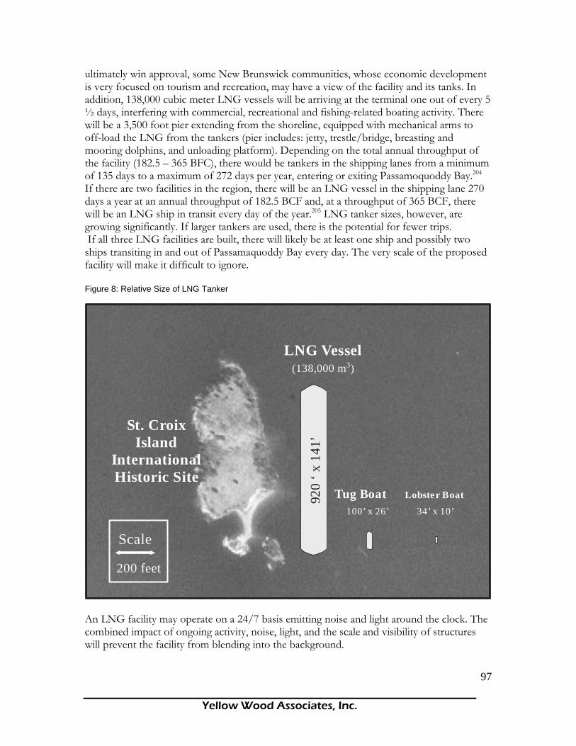
Yellow Wood Associates, Inc.
97
ultimately win approval, some New Brunswick communities, whose economic development is very focused on tourism and recreation, may have a view of the facility and its tanks. In addition, 138,000 cubic meter LNG vessels will be arriving at the terminal one out of every 5 ½ days, interfering with commercial, recreational and fishing-related boating activity. There will be a 3,500 foot pier extending from the shoreline, equipped with mechanical arms to off-load the LNG from the tankers (pier includes: jetty, trestle/bridge, breasting and mooring dolphins, and unloading platform). Depending on the total annual throughput of the facility (182.5 – 365 BFC), there would be tankers in the shipping lanes from a minimum of 135 days to a maximum of 272 days per year, entering or exiting Passamoquoddy Bay.204 If there are two facilities in the region, there will be an LNG vessel in the shipping lane 270 days a year at an annual throughput of 182.5 BCF and, at a throughput of 365 BCF, there will be an LNG ship in transit every day of the year.205 LNG tanker sizes, however, are growing significantly. If larger tankers are used, there is the potential for fewer trips. If all three LNG facilities are built, there will likely be at least one ship and possibly two ships transiting in and out of Passamaquoddy Bay every day. The very scale of the proposed facility will make it difficult to ignore. Figure 8: Relative Size of LNG Tanker
LNG Vessel
920
‘ x 1
41’
Tug Boat 34’ x 10’
Lobster Boat
200 feet
Scale
100’ x 26’
(138,000 m3)
St. Croix Island
International Historic Site
An LNG facility may operate on a 24/7 basis emitting noise and light around the clock. The combined impact of ongoing activity, noise, light, and the scale and visibility of structures will prevent the facility from blending into the background.

Yellow Wood Associates, Inc.
98
Interference with Access to the Water Another disamenity factor that will affect property values is the intermittent lack of access to the water and the navigational hazards posed by LNG tankers. The intermittent lack of access to the water will affect permanent residents but also second homeowners, of which there are many in the area. According to the 2000 U.S. Census, in Calais, 8 percent of the 1,921 housing units in the area are for seasonal, recreational or occasional use; in Robbinston, that figure is 24.9% of 329 units; in Perry, 25% of 529; and 7.1% of 1,061 units in Eastport. While this data is not available for the New Brunswick side, a look at age can help us in this regard. In 2001, in the islands of Grand Manan, Campobello Island and Deer Island, seniors made up more than 16% of the population.206 The Charlotte County region has a slightly higher percentage of seniors than in the Province of New Brunswick and Canada, with the resort town of St. Andrews having the largest percentage in the region. The population of St. Andrews nearly doubles in the summer months due to its seasonal population.207 These statistics point to the fact that the Passamaquoddy Bay has a significant number of seasonal residents, who presumably come in the summer season for its proximity and access to the water. Many of these seasonal residents may have moorings, docks or boats that need to be put into the water at public landings. Risk and Nuisance Effects LNG does not explode while in its liquid state, but it is highly flammable and can be explosive in concentrations that occur as it changes from a liquid to a gas. Natural gas is odorless and colorless prior to adding the odor, so a LNG leak could go unnoticed. LNG, like other liquid fuels, must vaporize and mix with a proper amount of oxygen to burn. Methane, the principal component of LNG, has a wide flammability range compared to most other gaseous fuels. The low boiling point of LNG (-260°F) makes it particularly unstable and difficult to maintain in a liquid state. Adding to the danger, LNG storage tanks are not operated above ambient pressure; therefore it is possible for air to enter a storage tank and produce an explosive mixture. The explosive potential of LNG is demonstrated clearly by its use as a fuel in internal combustion engines. In recognition of the actual hazards associated with LNG, the U.S. Department of Transportation Office of Pipeline Safety, through The Pipeline Safety Act of 1992, requires thermal radiation exclusion zones and flammable vapor-gas exclusion zones surrounding LNG facilities.208Each of these zones is calculated on a facility-by-facility basis using computer models developed for this purpose. No calculations have been made for any of the proposed Passamaquoddy Bay LNG facilities. LNG tankers and facilities are subject to the Maritime Transportation Security Act of 2002 developed by the Department of Homeland Security in response to the terrorist attacks of September 11, 2001. It should be noted that the federal government is taking the threat of terrorist attack on LNG tankers and facilities seriously. The LNG terminal in Everett, Massachusetts was closed for a time following the September 11th attack to assess and improve security procedures. The Coast Guard established temporary safety and security zones for LNG vessel transits and anchorage operations that temporarily closed all waters of Massachusetts Bay within a 500 yard radius of all LNG vessels anchored in Broad Sound and

Yellow Wood Associates, Inc.
99
established a zone one mile ahead, one mile astern, and one thousand yards on each side of any LNG vessel transiting inbound or outbound of Boston Harbor. Today, security is extremely tight. The shipments are never announced in advance, tankers are surrounded by armed patrol boats, the Tobin Bridge is shut down, and police with M-16 rifles patrol waterfront property.209 Overflights of commercial aircraft at Logan Airport are suspended.210 “The security zone prohibits entry into or movement within this portion of Broad Sound and Boston Harbor and is needed to safeguard the LNG vessels, the public and the surrounding area from sabotage or other subversive acts, accidents, or other events of a similar nature.”211 In July 2002, the Coast Guard imposed a 1,000 yard security zone around the Kenai LNG terminal and subsequently imposed similar zones around other U.S. LNG terminals.212 Regulations mandate both a safety zone and a security zone for all LNG ships.213 An assessment of LNG security risks prepared by the Congressional Research Service for the U.S. Congress states, “LNG tankers and land-based facilities are vulnerable to terrorism. Tankers may be physically attacked in a variety of ways to destroy their cargo or commandeered for use as weapons against coastal targets. Land-based LNG facilities may also be physically attacked with explosives or through other means. Alternatively, computer control systems may be ‘cyber-attacked,’ or both physical and cyber attack may happen at the same time. Some LNG facilities may also be indirectly disrupted by other types of terror strikes, such as attacks on regional electricity grids or communications networks, which could in turn affect dependent LNG control and safety systems. Since LNG is fuel for power plants, heating, military bases, and other uses, disruption of LNG shipping or storage poses additional ‘downstream’ risks, especially in more dependent regions like New England.”214
Jerry Havens, in an article for the Bulletin of Atomic Scientists, explains, “Today, accounting for less probable events such as terrorist attack is, and must continue to be, an important consideration in the planning of LNG facilities. For nearly 50 years now, all discussions of risk and probability in LNG transport have focused on how to account for human errors. The new reality is that we must now consider malicious acts as well.” 215
General Richard A. Clark, in the report LNG Facilities in Urban Areas: A Security Risk Management Analysis for Attorney General Patrick Lynch Rhode Island216, explains that Al Qaeda is interested in killing large numbers of Americans, conducting attacks in the U.S., damaging the U.S. economy and infrastructure, and damaging oil and gas infrastructure. While the Passamaquoddy Bay area, if LNG development happens, will certainly have gas infrastructure, its remote, rural character make it less of a target for terrorists who want to kill large numbers of Americans. For Rhode Island, for example, General Clarke notes that
“the LNG off loading facility could be sited in a location that did not involve either an urban environment for the facility or an inland waterway transit for the LNG tanker. Locating the facility in a non-urban environment and eliminating the inland waterway transit would significantly reduce both the attractiveness to terrorists of an attack (because the attack would not generate large scale casualties) and the consequence management and recovery burdens on governments should an attack occur. GAO, the investigatory arm of the Congress, recommended in 1979 that the Congress or Administration prohibit any additional large scale LNG facilities in or LNG tanker transit through urban areas.”
____________________________________________________________________Yellow Wood Associates, Inc.
100
Radius of Concern Associated with Land-based LNG Facilities In the absence of calculated thermal exclusion zones and flammable vapor-gas exclusion zones specific to various sites in Passamaquoddy Bay, the best we can do to get a sense of the size of the area in question is to reference studies related to other proposed, operational, and approved LNG terminals. The environmental impact statement for the Hackberry LNG terminal explains, “If a large quantity of LNG is spilled in the presence of an ignition source, the resulting LNG pool fire could cause high levels of thermal radiation.” The exclusion zone calculations for Hackberry range from 321 feet at a minimum to 929 feet from each storage tank depending on the source of the fire. Both these distances are associated with an exposed person experiencing burns within 30 seconds. At a distance of 709 feet, offsite structures used for occupancies or residences would not be expected to burn, though exposed persons would experience burns within 10 seconds. At a distance of 383 feet, clothing and wood can ignite spontaneously. “A large quantity of LNG spilled without ignition would form a flammable vapor cloud that would travel with the prevailing wind until it either dispersed below the flammable limits or encountered an ignition source.”217 The flammable vapor dispersion zone calculated for Hackberry, Louisiana, LNG terminal ranges from 495 feet to 771 feet, depending on which of three tanks is being considered. These estimates were considered conservative (too low) by agencies reviewing the Hackberry Environmental Impact Statement because, among other things, they did not account for interaction between the three tanks. The effects of a pool fire on land could easily extend half a mile or more.
Jerry Havens 218 has reviewed the work performed in the last 25 years on this question. He explains, “With few exceptions, the scientific consensus on the scope of an LNG-on-water spill fire involving an entire tank of LNG is that it would be at least a half-mile in diameter. Scientists also seem to agree that from the edge of the fire to about another half-mile out, people would receive second-degree burns on unprotected skin within about 30 seconds. Obviously, larger fires would result from larger spills.” In another article, Havens explains219,
“In my judgment, a large LNG pool fire--on water, and therefore uncontained--is of the highest concern. It is reasonable to be concerned about the damage potential of such fires. Most predictions suggest that even the largest LNG tankers (typically more than 900 feet in length) might be completely enveloped in a pool fire following a complete spill of a single 6.5 million gallon tank. This raises questions about the vulnerability of the ship and the potential for additional releases. A typical LNG tanker contains as many as five tanks with a combined capacity of 33 million gallons. We do know some things about such fires. They could not be extinguished and would have to burn themselves out. Unlike some other flammable liquids such as crude oil, the gas would burn itself out only when it was totally consumed. And such fires would be expected to burn more rapidly and with greater intensity than crude oil or even gasoline fires.”
Dr. James Fay has some information relevant to the Passamaquoddy Bay area,220
“The federal safety requirements for the proposed Pleasant Point LNG terminal will not prevent harm to humans outside the site boundary for the spill scenarios that FERC considers. For all credible spills, including terrorist attacks on the storage tank and LNG

____________________________________________________________________Yellow Wood Associates, Inc.
101
Impact Zone Moderate Severe
Within 1/2 Mile of Site 20% 35%
Within 1 Mile of Site 10% 25%
Within 2 Miles of Site 5% 15%
Within 2 Miles of Transit Route 5% 10%
Property Value Discount Rates
tanker, the danger zone for humans extends almost 4 miles from the terminal site, encompassing 20 square miles of land in the Pleasant Point area. For a tanker spill anywhere along the route leading to the LNG terminal, the thermal radiation danger zone for humans extends 1.5 miles from the tanker route, encompassing up to 4 square miles of land along U.S. and Canada shores in Eastport, Campobello Island and Deer Island, depending upon the spill location along the tanker track.”
What is the likely impact on property values of one or more LNG terminals? To determine the likely impact on property values of one or more LNG import terminals in Passamaquoddy Bay, we began by collecting 2005 property value data from each of three potential host communities. We determined the number and value of properties within half a mile, one mile, and two miles of each proposed site, and the number and value of properties within two miles of the LNG vessel in transit (See Map#19). For each of these impact zones, a discount rate was applied (Table 17). No properties were double-counted. In some instances, properties in adjacent towns were affected by sites in host communities. Table 21: Zones of Impact and Property Value Discount Rates
The property value discount rates above (Table 21) used in the following property value analysis were estimates developed using literature on disamenities and their impacts on property values. These are conservative estimates of the impacts of disamenities in rural areas, compared to a similar analysis done in Harpswell, Maine. The rates used in Harpswell were developed through talking with realtors in that area. Table 22 below show the number of affected properties, their 2005 assessed value for each of three potential sites labeled northern, middle, and southern. Total assessed values exclude tax exempt properties. Since some of the properties within a two mile radius of proposed sites are in other communities, property value and thus property tax revenue impacts will be felt beyond the boundaries of host communities.

____________________________________________________________________Yellow Wood Associates, Inc.
102
Table 22: Number of Affected Properties, their Assessed Values and Total Town Assessed Values
ZONEAFFECTED
PROPERTIES
ASSESSED VALUE OF PROPERTIES
AFFECTED Calais Property Value
1/2 MILE 6 $363,3001 MILE 46 $2,237,0002 MILE 134 $6,414,300TOTAL 186 $9,014,600 $109,211,700
ZONEAFFECTED
PROPERTIES
ASSESSED VALUE OF PROPERTIES
AFFECTEDRobbinston Property
Value
1/2 MILE 39 $1,777,7251 MILE 163 $7,380,8922 MILE 371 $15,991,436TOTAL 573 $25,150,052 $23,634,932
ZONEAFFECTED
PROPERTIES
ASSESSED VALUE OF PROPERTIES
AFFECTEDEastport Property
Value
1/2 MILE 6 $145,6471 MILE 37 $1,242,4982 MILE 332 $13,338,487TOTAL 375 $14,726,632 $51,757,465
MIDDLE SITE (MILL COVE)
NORTHERN SITE (DEVIL'S HEAD)
SOUTHERN SITE (SPLIT ROCK)
The number of properties potentially affected by adverse property value impacts as a result of LNG import terminals ranges from a low of 186 at the northernmost site to 573 at the middle site. If all three sites were developed, 1,134 properties would be affected. The overall ratio of the value of affected properties to the value of non-exempt properties overall overstates impacts somewhat since some affected properties are in adjacent, non-host communities. Specifically, 133 of the properties affected at the middle site are in Perry as are 113 of the properties affected by the southern site. The ratio of values of affected properties (within and outside the host community) to total non-exempt host community valuation are 106% in Robbinston, 28% in Eastport, and 8% in Calais. The next step in assessing impact involves assigning values to the extent of anticipated property value effects based on the distance of each property from the LNG site. The values we have selected represent moderate to severe property value effects. We believe these effects are entirely consistent with current reality, particularly given the increased threat of

____________________________________________________________________Yellow Wood Associates, Inc.
103
domestic terrorism and the understandable reluctance of most people to live next to a potential terrorist target. The tables below show the reduction in property values anticipated under moderate and severe impact scenarios for the northern, middle, and southern sites. Table 23: Affected Properties Within Each Zone, Assessed Values and Value Reductions for Three Proposed Terminal Sites.
Based on the mil rates for each town, reductions in property value will reduce tax revenue by approximately $12,700 to $33,665 in Calais, by approximately $18,513 to $47,500 in Robbinston, and by approximately $16,400 to $47,300 in Eastport. These reductions will occur as the demand for municipal staff and services increases. Radius of Concern for Properties along the LNG Transit Route
Marine-based hazards are different from land-based hazards. Whereas the land-based facilities have features to limit the duration of LNG spills and contain credible spill volumes, any LNG spill on water would be unconfined and would vaporize rapidly due to heat input from the water.221 Spilled LNG will vaporize quickly, especially when spilled on water. If ignited, the fire will hasten the vaporization and can result in an uncontrollable
ZONEModerate Severe
1/2 MILE $72,660 $127,1551 MILE $158,220 $395,5502 MILE $248,705 $746,115
TOTAL $479,585 $1,268,820
ZONEModerate Severe
1/2 MILE $355,545 $622,2041 MILE $738,089 $1,845,2232 MILE $799,572 $2,398,715
TOTAL $1,893,206 $4,866,142
ZONEModerate Severe
1/2 MILE 29129.4 50976.451 MILE 124,250 310,6252 MILE 666,924 2,000,773
TOTAL $820,304 $2,362,374
REDUCTION IN PROPERTY VALUE
NORTHERN SITE (DEVIL'S HEAD)
MIDDLE SITE (MILL COVE)
SOUTHERN SITE (SPLIT ROCK)
REDUCTION IN PROPERTY VALUE
REDUCTION IN PROPERTY VALUE

____________________________________________________________________Yellow Wood Associates, Inc.
104
conflagration. This type of pool fire may occur if LNG is released from a tanker into the water or spilled out of a storage tank. If there were no nearby ignition source, the combustible vapor cloud would move with the wind and could trigger an off-site fire called a plume fire. While methane gas is normally lighter than air, in its just-vaporized state, it is denser than the surrounding air and would follow the ground until it warms. LNG vapors must warm up by 100°F, from -259°F (-161°C) to -160°F (-107°C), in order to become lighter than air and start rising. Once ignited, a plume would burn back to the source. LNG burns extremely hot and very fast and a large pool fire or a plume fire would most likely have to burn out and could not be extinguished. A safety study of a proposed power plant and LNG terminal on Mare Island in Vallejo, California concluded, “A 6,600,000 gallon release of LNG from a 16-foot hole in an LNG carrier into the Bay without ignition could form a cigar-shaped flammable plume that could reach distances between 0.6 mile and 2.5 miles depending on wind speed and terrain. A plume from a release of the contents of a large storage tank through a 16 foot hole could reach distances between 1.6 and 3.2 miles depending on wind speed and terrain. If ignited, a plume will burn back to the spill source, and people within a burning plume will be killed, and houses and vegetation will be ignited.222
"If even one of the five tanks onboard an LNG ship spilled onto the water, the fire it would produce would be up to a half-mile in diameter," explained Jerry Havens, a chemical engineer and former director of the Chemical Hazards Research Center at the University of Arkansas. "The thermal radiation ... could burn people a half mile from the fire's edge," says Dr. Havens, who helped write federal standards for estimating the size and intensity of fires involving LNG.223
"On land, you have to look at a spill from the largest transfer line that lasts 10 minutes. That means when somebody submits an application today, they have to model for that spill. That's the one used to set their hazard exclusion zones," said Jerry Havens. Havens and other scientists contend that safety zones based on the limited, 10-minute spill could not protect the public from the kind of fire that would result from an LNG tanker accident. If hazard exclusion zones become the tool of choice for complying with the remote siting requirement, Havens said those zones might need to extend a mile or more from the LNG terminal to account for the risks posed by tankers.224
James Fay, Massachusetts Institute of Technology (MIT) professor emeritus, calculated the pool fire and thermal radiation zones for a maximum LNG spill of 6,000 metric tons or 14,300 cubic meters – approximately 7% of a 200,000 cubic meter tanker’s capacity. The pool fire would last 3.3 minutes with a maximum radius of 340 meters (1115.5 feet). A pool fire would burn too hot and too fast to be extinguished and the potential for retarding the spread of the fire is nonexistent. The thermal radiation damage zone within which people would experience burns and buildings would catch fire is about 1.1 kilometers (0.66 mile or 3,484.8 feet) from the spill site in every direction, covering a land area of about 1.9 square kilometers (1.14 square miles).225According to Fay, a ship needs to be about two-thirds of a mile from any spot where people could be exposed to a fire. The damaging heat of a fire will extend nearly a mile from the outer edge of the fire, not simply a mile from the spill source.226
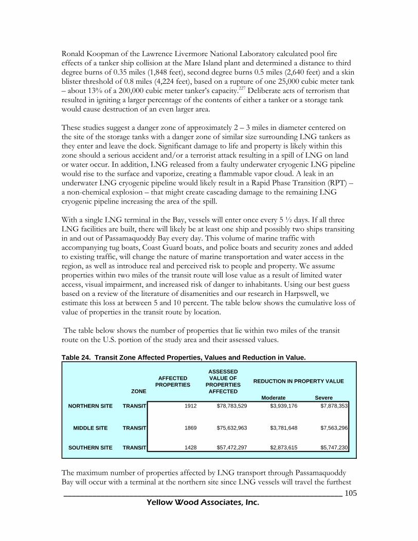
____________________________________________________________________Yellow Wood Associates, Inc.
105
Ronald Koopman of the Lawrence Livermore National Laboratory calculated pool fire effects of a tanker ship collision at the Mare Island plant and determined a distance to third degree burns of 0.35 miles (1,848 feet), second degree burns 0.5 miles (2,640 feet) and a skin blister threshold of 0.8 miles (4,224 feet), based on a rupture of one 25,000 cubic meter tank – about 13% of a 200,000 cubic meter tanker’s capacity.227 Deliberate acts of terrorism that resulted in igniting a larger percentage of the contents of either a tanker or a storage tank would cause destruction of an even larger area. These studies suggest a danger zone of approximately 2 – 3 miles in diameter centered on the site of the storage tanks with a danger zone of similar size surrounding LNG tankers as they enter and leave the dock. Significant damage to life and property is likely within this zone should a serious accident and/or a terrorist attack resulting in a spill of LNG on land or water occur. In addition, LNG released from a faulty underwater cryogenic LNG pipeline would rise to the surface and vaporize, creating a flammable vapor cloud. A leak in an underwater LNG cryogenic pipeline would likely result in a Rapid Phase Transition (RPT) – a non-chemical explosion – that might create cascading damage to the remaining LNG cryogenic pipeline increasing the area of the spill. With a single LNG terminal in the Bay, vessels will enter once every 5 ½ days. If all three LNG facilities are built, there will likely be at least one ship and possibly two ships transiting in and out of Passamaquoddy Bay every day. This volume of marine traffic with accompanying tug boats, Coast Guard boats, and police boats and security zones and added to existing traffic, will change the nature of marine transportation and water access in the region, as well as introduce real and perceived risk to people and property. We assume properties within two miles of the transit route will lose value as a result of limited water access, visual impairment, and increased risk of danger to inhabitants. Using our best guess based on a review of the literature of disamenities and our research in Harpswell, we estimate this loss at between 5 and 10 percent. The table below shows the cumulative loss of value of properties in the transit route by location. The table below shows the number of properties that lie within two miles of the transit route on the U.S. portion of the study area and their assessed values. Table 24. Transit Zone Affected Properties, Values and Reduction in Value.
ZONE
AFFECTED PROPERTIES
ASSESSED VALUE OF
PROPERTIES AFFECTED
Moderate SevereNORTHERN SITE TRANSIT 1912 $78,783,529 $3,939,176 $7,878,353
MIDDLE SITE TRANSIT 1869 $75,632,963 $3,781,648 $7,563,296
SOUTHERN SITE TRANSIT 1428 $57,472,297 $2,873,615 $5,747,230
REDUCTION IN PROPERTY VALUE
The maximum number of properties affected by LNG transport through Passamaquoddy Bay will occur with a terminal at the northern site since LNG vessels will travel the furthest
____________________________________________________________________Yellow Wood Associates, Inc.
106
to reach the site. These properties number 1,912. Vessel transit related to development of an LNG terminal at the southern site will still impact 1,428 properties in the U.S. portion of the study area, a substantial number. The resulting loss in property value will impact every town in the path of an LNG vessel, not only host communities. Pipeline Safety The third area of property value impact is in construction and operation of the lateral natural gas pipeline required to connect any LNG import terminal with the Maritime and Northeast Pipeline. Towns affected by the pipeline include inland as well as coastal communities. Natural gas pipelines pose additional significant public safety and emergency management issues in rural areas. Pipelines incidents occur almost daily in the United States. In the last three years, natural gas transmission pipeline incidents have resulted in an annual average of six deaths, 10 injuries, and $20 million in property damage. Causes and contributors to pipeline failures include construction errors, material defects, internal and external corrosion, operational errors, malfunctions of control systems or relief equipment, and outside force damage (e.g., by third parties during excavation). “A systems approach to risk management that uses quantifiable mitigation measures (such as setbacks, warning signs, and alarm and evacuation procedures) and prevention measures (such as design, inspection, and maintenance of pipelines) would likely improve pipeline safety across the nation.” One method to accomplishing this is a management plan for long-term communication of risk and interplay of perceptions among all stakeholders, especially pipeline operators, local officials, and the public. 228 In addition, the natural gas industry has an emergency contact directory, which contains key contacts for interstate natural gas pipelines. These contacts are used in any type of emergency such as a pipeline incident, a significant electric outage, a weather-related disaster.229 Pipelines in the Passamaquoddy Bay region will cross some private property. The right-of-way for a pipeline is generally 75-100 feet wide during construction, but 50 feet for the permanent right-of-way. Landowners still pay taxes on this land, even though their use of this land is restricted. 230 The American Petroleum Institute (API) in 2003 “recommends setbacks of 50 feet from petroleum and hazardous liquids lines for new homes, businesses, and places of public assembly. It also recommends 25 feet for garden sheds, septic tanks, and water wells and 10 feet for mailboxes and yard lights. Many local governments are going beyond the federal regulations on the size of setbacks from pipelines. Following the deaths of three boys resulting from a ruptured gasoline transmission line and the subsequent ignition of the fuel in June 1999 in Bellingham, Washington, the community and state began addressing the need for more effective state and local scrutiny of pipeline operations. One outgrowth of that effort was a model ordinance to be developed for consideration and use of local governments. This recommends a minimum setback of 50 feet for hazardous liquids. For gas transmission lines, it recommends setback distances “consistent with the hazard area radius” for pipelines of various diameters and pressurization that were developed in a report for the Gas Research Institute. Furthermore, it would require setback distances to be doubled for buildings where the public gathers for education, recreation, sports, conventions, hospitalization, or worship. 231 The City of Austin, Texas has similarly gone beyond federal

____________________________________________________________________Yellow Wood Associates, Inc.
107
regulations. Their zoning establishes restrictions within 200 and 500 feet of a pipeline. These distances are based on fire modeling and development requirements set to meet fire safety standards. The ordinance also bans new buildings within 25 feet of a hazardous liquids pipeline and increases construction and building standards on most structures within 200 feet of a pipeline. The ordinance forbids new structures requiring extra evacuation assistance, such as schools and hospitals, within 200 feet of a pipeline. 232 Economic Impacts of Proposed Pipeline Laterals Permanent Right of Way (ROW) Given the lengths of the potential pipeline laterals from the three LNG sites to the Maritimes and Northeast Pipeline (MNP) (see Table 1 on page 15), Yellow Wood calculated the number of acres that would be occupied by a 50 foot permanent right-of-way (25 feet on either side of the pipeline) along the length of each pipeline segment. The approximate acreage of land within the right-of-way is summarized in the table below by LNG site (for a detailed breakdown of the number of acres by pipeline segment and by town, refer to Appendix D). Table 25: Total Area of 50 foot ROW for Pipeline from each LNG Site233 Segment Name Area (acres) Split Rock MNP 184 Mill Cove MNP 129 Devil’s Head MNP 103
Using average property values for each town, the total estimated value of the above acreages were calculated.234 The total value of these properties was then used to estimate the tax revenue generated using the 2003 mill rates for each town.235 Table 26: Total Estimated Value of Property and Estimated Tax Revenue for Properties within the 50 ft ROW for Pipeline from each LNG Site236
Segment Name Property Value Estimated Tax
Revenue Split Rock MNP $131,848 $2,376 Mill Cove MNP $97,093 $1,949 Devil’s Head MNP $111,272 $2,628
It is unclear at this time what the arrangement will be between the local towns and the LNG companies regarding compensation for those properties within the pipeline routes. Additional Setback If the towns impacted by the pipeline decide, in lieu of the safety issues discussed above, to go beyond the federal regulations and stipulate additional setbacks from the pipeline, there would be economic consequences to affected property owners. If we assume that a local ordinance specifies restrictions on the use of property within 150 feet of the pipeline, the total impact is significantly greater. The table below summarizes the impact of a 150 foot setback on the total number of acres affected. Note that the total acreage affected by the additional setback does not include the area within the 50 foot ROW, which is treated
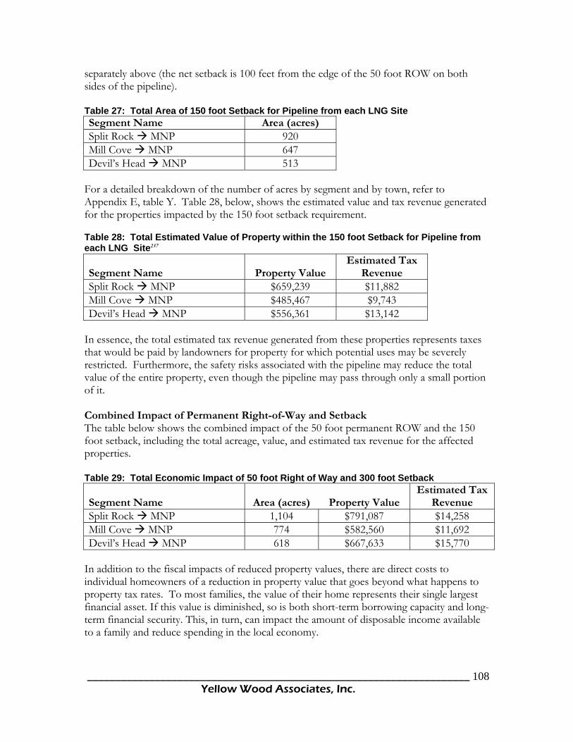
____________________________________________________________________Yellow Wood Associates, Inc.
108
separately above (the net setback is 100 feet from the edge of the 50 foot ROW on both sides of the pipeline). Table 27: Total Area of 150 foot Setback for Pipeline from each LNG Site Segment Name Area (acres) Split Rock MNP 920 Mill Cove MNP 647 Devil’s Head MNP 513
For a detailed breakdown of the number of acres by segment and by town, refer to Appendix E, table Y. Table 28, below, shows the estimated value and tax revenue generated for the properties impacted by the 150 foot setback requirement. Table 28: Total Estimated Value of Property within the 150 foot Setback for Pipeline from each LNG Site237
Segment Name Property Value Estimated Tax
Revenue Split Rock MNP $659,239 $11,882 Mill Cove MNP $485,467 $9,743 Devil’s Head MNP $556,361 $13,142
In essence, the total estimated tax revenue generated from these properties represents taxes that would be paid by landowners for property for which potential uses may be severely restricted. Furthermore, the safety risks associated with the pipeline may reduce the total value of the entire property, even though the pipeline may pass through only a small portion of it. Combined Impact of Permanent Right-of-Way and Setback The table below shows the combined impact of the 50 foot permanent ROW and the 150 foot setback, including the total acreage, value, and estimated tax revenue for the affected properties. Table 29: Total Economic Impact of 50 foot Right of Way and 300 foot Setback
Segment Name Area (acres) Property Value Estimated Tax
Revenue Split Rock MNP 1,104 $791,087 $14,258 Mill Cove MNP 774 $582,560 $11,692 Devil’s Head MNP 618 $667,633 $15,770
In addition to the fiscal impacts of reduced property values, there are direct costs to individual homeowners of a reduction in property value that goes beyond what happens to property tax rates. To most families, the value of their home represents their single largest financial asset. If this value is diminished, so is both short-term borrowing capacity and long-term financial security. This, in turn, can impact the amount of disposable income available to a family and reduce spending in the local economy.

____________________________________________________________________Yellow Wood Associates, Inc.
109
Observed Impacts to Date of Proposed LNG Terminals on Property Values in Passamaquoddy Bay Conversations with realtors and town leaders in the U.S. and Canada suggest impacts are already being felt. Some see evidence that new construction starts and sales of vacation properties in and around the proposed site in Perry have slowed. It is believed that landowners are reluctant to make investments in property that could lose value very soon and that prospective vacation home buyers’ enthusiasm for properties with views of a storage tank is weak. According to Cathy and Richard Berry in Robbinston238, a short term slowdown is already manifest. They expect long-term property values to be depressed because of the importance of the second/vacation home market and the undesirability of moving to an industrial area in the attempt to escape the one buyers already live in. Real estate is well integrated in the local economy so a slowdown affects not just property values and real estate but those providing services such as title attorneys, lenders, building inspectors, septic designers and well drillers. Realty sales in St. Andrews have slowed due to the possibility of LNG. Fred Burton239, a realtor with Charlotte Realty, states that real estate sales have definitely slowed and have been slowing since last fall. He believes this will continue and will kill the area of St. Andrews, especially tourism, fishing and tourism-related businesses. Realtors in both the U.S. and Canadian portions of the study area see evidence of property speculation close to the proposed sites as investors sense the opportunity to own what could become valuable sites for future development of energy dependent industries.240, 241 Some realtors have expressed the belief that the value of residential properties will increase at least during the construction phase,242 but others note that, due to a potential decline of fishing industries and the economy in general, the area has a surplus of vacant residences that would dampen any temporary upward price pressure for residential properties. 243 Neither are local real estate agents inclined to believe in the amenity value of LNG terminals. On the contrary, most believe a price premium will be deducted from primary residential or vacation class properties that would endure any of the nuisance factors of a site such as visual impacts.244,245 Perceived risk will also affect willingness to pay. Property Tax Tradeoffs A facility with a construction cost of $500 million will affect property tax revenues depending on the host community in which it is placed. For example, at the existing tax rate of $26.55 per $1,000, a facility in Calais assessed at $500 million would add $13.275 million to the revenue stream. A facility assessed at $500 million would add $4.89 million to the revenue stream in Robbinston. Of course, if communities choose to lower their property tax rates, these figures will go down accordingly. It is beyond the scope of this study to conduct a detailed fiscal impact analysis of specific host communities in Passamaquoddy Bay. However, such a study has been conducted for the Town of Harpswell, Maine in relation to an LNG import terminal of a scale comparable to the generic terminal used in this study. Harpswell is a far wealthier community than any of the potential host communities in Passamaquoddy Bay. Yet, even in Harpswell, with a property value base of over $841 million, the increased costs associated with municipal staffing and infrastructure required to accommodate an LNG import terminal without sacrificing safety and service quality was

____________________________________________________________________Yellow Wood Associates, Inc.
110
sufficient to more than offset the increase in revenues. For example, although the Harpswell analysis showed decreased tax rates over the three year construction period, for every year thereafter (up to 2025), the tax rates required to support the terminal exceeded those required without a terminal, even if half the lease money were applied directly to tax abatement. This would be the equivalent of applying half the property tax revenues from an LNG site in Passamaquoddy Bay directly to tax abatement. As in Harpswell, Passamaquoddy Bay host communities are also likely to experience an increased fiscal burden related to education as a result of property valuation changes related to the LNG terminal. As their property tax base increases, state education aid will decrease. None of the communities in Passamaquoddy Bay will be able to escape the fiscal impacts of the introduction of heavy industry through the presence of one or more LNG import terminals and any related secondary industrial development. Host communities may incur the highest costs, yet will have the tax revenue to at least partly compensate. Non-host communities will bear costs with no direct compensation in property tax revenue. This is a situation in which the decision of a single community can have regional consequences that may easily go unmitigated within the existing governmental and institutional framework. What are the alternatives to onshore LNG terminals? The technology for LNG import terminals has now advanced to the point where offshore terminals are becoming a reality. Offshore technology has been used for oil in the North Sea for 20 years. The first offshore LNG import terminal became operational 150 miles off the coast of Louisiana in early 2005. It uses a submerged turret offloading system to connect directly to specially designed LNG tankers. LNG is first vaporized on board the vessels, and then the resulting natural gas is sent through regular natural gas pipelines to shore. As of September 2005, two other deepwater port facilities have been approved and eight applications are pending. Each facility is located beyond the adjacent state’s seaward boundary of three miles. Offshore terminals are regulated by Marine Administration (MARAD) and the U.S. Coast Guard under the Deepwater Port Act. The Act requires approval by the governor of the adjacent coastal state.246At a public symposium on LNG in Brunswick, Maine in July 2004, Excelerate Energy identified four key motivations for offshore LNG development:
1. Enhances safety and security by keeping a buffer to infrastructure and population. 2. Avoids port related vessel traffic, weather delays, and daylight restrictions. 3. Reduces onshore and near shore impacts of dredging and site preparation. 4. Allows projects to target specific markets where supply is needed.247
What do experts say about the strengths and future potential of the region’s economy? Numerous studies have recommended steps to strengthen the economy of the region through increased attention to natural resource-based production and processing, tourism, and small-scale manufacturing on the U.S. side and tourism, aquaculture, biotechnology and information technology on the Canadian side. Natural resource-based manufacturing, renewable wind energy and fisheries are among strategies recommended for the Passamaquoddy Bay area. To date, no studies have been identified that consider the future
____________________________________________________________________Yellow Wood Associates, Inc.
111
of the study area as an economic entity in its own right. Generally speaking, studies of the economy of Washington County do not reference development partnerships with Charlotte County and vice versa.248Generally speaking, studies of Washington County economic development futures do not emphasize partnerships with the Passamaquoddy Tribe. Regionalism is an important concept in rural community economic development. Communities that work together with their neighbors to create shared assets, avoid duplication of effort, invest strategically for mutual benefit and present a united message regarding their desired future are often able to obtain a quality of life collectively that they could not individually achieve. The challenge of regionalism for the communities of Passamaquoddy Bay is heightened by the international boundary and the status of the Passamaquoddy Tribe as an independent nation. The incentive for regional cooperation is the prospect of shared mutual benefit derived from bringing the unique strengths of all parties to bear in creating solutions that improve quality of life for all rather than for some at the expense of others. The best development is that which opens new opportunities without imposing unacceptable opportunity costs. This can only occur through partnerships in which all partners are committed to finding the best solutions for everyone with a legitimate stake in the future of the region and its communities. All the studies of economic development potential in the Passamaquoddy Bay region reviewed for this report share certain commonalities:
1. They recognize the essentially rural character of the communities that ring Passamaquoddy Bay and the significance of the region’s cultures and historic built environment.
2. They emphasize the importance of protecting the natural environment upon which all economic activity in the region has historically been based. Although the forms of that activity have changed over the years and will likely continue to change, the indigenous natural resource base is seen as the region’s key comparative advantage. The key is adding value to the region’s assets without undermining them while retaining economic benefits locally.
3. They support fostering home grown development and entrepreneurship from the grassroots up combined with strategic attraction of investment to anchor key sectors of the economy. An example would be one or more destination tourism resorts.
4. They acknowledge that the private sector’s capacity to develop is dependent, in part, on the infrastructure provided by, or with the support of, the public sector.
5. They recognize the value to communities of a diversified economy both within and between sectors.
The most recent study of economic development opportunities for Washington County is the Report on an Economic Development Strategy for Washington County prepared for the State of Maine by David Flanagan and released November 17, 2005. Opportunities identified for the region include:
• Attracting visitors and retirees • Strengthening natural resource-based industries • Developing needed energy resources

____________________________________________________________________Yellow Wood Associates, Inc.
112
• Providing resources and support for local economic development initiatives and leadership at the state level.
The most recent study of economic development opportunities for Charlotte County is the Economic Base Analysis prepared for Enterprise Charlotte Community Economic Development Agency by Matthew Fischer & Associates. Recommendations include:
• Strengthening the fishing and fish processing industry • Focusing entrepreneurial interest on new retail and personal service businesses to
stem the outflow of wealth to more populated areas • Developing tourism to attract aging “baby boomers”
Each of these strategies is discussed below in relation to its compatibility with one or more LNG import terminals in Passamaquoddy Bay. The second phase of this study is intended to provide more detailed economic impact analyses of one or more LNG terminals on fisheries and tourism. Tourism Tourism is seen as an important economic development opportunity for the study area on both sides of the border and by a wide variety of organizations. For example, in its Action Plan 2001-2006, the Gulf of Maine Council on the Marine Environment lists as its third goal, “Encourage sustainable maritime activities. The Council’s vision for 2025 is that marine research and nature-based tourism provide unique and significant economic opportunities for the region.”249 The Gulf of Maine Council was created by the governors and premiers of the states and provinces bordering the Gulf of Maine to help “protect the Gulf’s ecological integrity and the many uses that depend upon its continued good health.” Maine and New Brunswick are included in the Council and Passamaquoddy Bay is part of the Gulf of Maine. It is not only the Gulf of Maine Council that recognizes the relationship between natural resources and tourism potential. The very first sentence in a report on Maine’s Natural Resource-based Industries produced in 2004 for the Maine Governor’s Steering Committee on Natural Resource-based Industries states, “Tourism, outdoor recreation in particular, is highly dependent on Maine’s natural resources. Many people visit Maine for Maine’s clean lakes, rivers, and beaches, pristine views, and unspoiled back country. What’s more, tourism’s vitality is uniquely dependent upon the other sectors – fishing, farming, and forestry. Active fishing villages, open farm landscapes, and vast forests are all tourism resources.”250 Experiential tourists seek to engage in activities “from which they can develop a deeper understanding of a region, its unique natural attributes, and its local history and culture.” Experiential tourists make up a sizable portion of the tourist market. They are interested in places that are “remote and untouched” and have distinct cultural attributes. According to Fermata’s research, experiential tourists look for primary opportunities: to enjoy the sights, smells, and sounds of nature; to be outdoors; to see wildlife species not seen before; and to get away from the demands of everyday life. Add to that the fact that the leading types of marketable trips to Downeast Maine and Acadia are for outdoor trips, touring trips, and cruise trips to experience the natural environment and engage in outdoor activities in and

____________________________________________________________________Yellow Wood Associates, Inc.
113
through areas of scenic beauty. The area is an important Spring and Fall bird migration flyway – a good spot for watching puffins, auks, and storm petrels. Downeast and Acadia is seen by tourists as providing a top notch experience, and nearly 60% of all overnight visitors take advantage of the scenic byway (Route 1). Nearly ¾ of overnight visitors strongly agree that their experience is “worry free.” Nearly 1 in 5 visitors arrive by boat.251 To link demand with supply, Fermata recommends creating a Downeast Wildlife and Heritage Trail that would include the study region and tie into exhibits and storylines at the Downeast Heritage Center. Others would like to see greater opportunities for guided trips from a base camp. Charles Calhoun recommends inviting a major resort facility to come in, combining eco-tourism with cultural tourism and marketing Washington County as a gateway to the Maritimes.252 The Down East Sustainable Tourism Initiative Year 2010, which addresses itself to Washington and Hancock Counties, seeks to provide a roadmap for sustainable tourism, noting that increasing overnight visitors from the current 57,000 to 68,400 is estimated to generate an additional $4.9 million annually to the county economy. Tourism already contributes substantially to economic well-being in the Canadian portion of the study area, where there has been significant investment in tourism infrastructure by both government and non-government entities. For example, there is a provincial visitor information center in St. Stephen and municipal visitor information centers in Saint Andrews, Black’s Harbour, Saint George, Campobello Island and Grand Manan. There are tourist accommodations in every town in the study region and tourist attractions including: The Chocolate Museum in St. Stephen, Kingsbrae Gardens in Saint Andrews, New River Beach in Black’s Harbour, and the Roosevelt Campobello International Park (which attracts 130,000 visitors annually) and Herring Cove Provincial Park on Campobello Island, and Hole-in-the-Wall Park and The Anchorage Provincial Park on Grand Manan. Mainland New Brunswick towns in the study area are part of the Fundy Coastal Drive promoted by the New Brunswick Department of Tourism. The Fundy Coastal Drive does not include Deer Island, Campobello Island, and Grand Manan. Charlotte County has the fourth largest tourism infrastructure in New Brunswick measured by the number of bedrooms for tourists. Ferry services are integral to tourism in this region. The Deer Island – Campobello Island ferry is the only connection between Campobello Island and mainland Canada without having to go through the U.S. Therefore, due to customs complications, it’s the only way to get some items (for example: beef products) from the Canadian mainland to Campobello Island. The Deer Island – Eastport ferry is similarly important to the region, as it is one of the routes for tourists traveling to Deer Island, Eastport, and surrounding communities on both sides of the border. The Quoddy Loop, an organization marketing this region, was developed in 1989 by a cooperative effort between New Brunswick and Maine. Its intent was to promote the greater international Passamaquoddy Bay area to tourists. While the Quoddy Loop organization dissolved in 1994, a website (www.Quoddy Loop.com) has been active since 1996. The Economic Base Analysis prepared for Enterprise Charlotte Community Economic Development Agency by Matthew Fischer & Associates recommends the region “focus
____________________________________________________________________Yellow Wood Associates, Inc.
114
tourism initiatives on the changing interests of aging ‘baby boomers’ (50+) that are giving up skiing, wilderness camping and rock climbing for more sedentary pursuits such as: golf holidays, edu-tourism, cultural tourism, heritage sites, eco-tourism and birding, etc. Look at the ‘Elderhostel Program’ as a model. Also with higher disposable incomes they enjoy B&Bs and 4-star accommodations, fine dining, shopping, theater. Highlight opportunities for entrepreneurs to create new restaurants, accommodations, and tourism services. Help existing operators form market co-ops. Package and market 2, 3, & 4 day tours of the region; self guide or bus tours.” 253 In contrast to the Canadian side, Washington County currently receives the smallest share of Maine’s tourist market with 1.5% of the overnight visits to the state. Tourist travel to Washington County is estimated at 57,000 overnights and 261,000 day trips per year. According to Destiny 2010, Washington County’s tourism economy is based largely on “pass through” visitation between the Canadian Maritimes and Acadia National Park.254 Development of tourism in Washington County has been hindered by lack of investment in infrastructure and promotion. As a result of these and other factors such as gas price increases and increased security at the Canadian border since 9/11, investment in the Downeast Heritage Museum (intended as a focal point for tourists entering Washington County through Calais) has not reached its visitor projections. The new international bridge between Calais and Saint Stephen will make it even easier for tourists entering from Canada to bypass downtown Calais and reduce the probability of traveling south on US-1. Specific recommendations based on cooperation between Canadian and U.S. interests are outlined in David Flanagan’s recent Report on an Economic Development Strategy for Washington County. The report also includes specific recommendations for boosting Washington County tourism through investments in signage, rest areas, information centers, and cyberspace, and through further development and promotion of a variety of experiences linked to the rural landscape such as rail-trails, public parks and lands, and the Moosehorn National Wildlife Refuge (possible location for at least a portion of the pipeline required by one or more LNG facilities in the study area.) Most notably, Flanagan recommends greater promotion of the St. Croix International Waterway, which is a Canadian Heritage River as well as a joint project of the U.S. and Canadian governments to attract outdoor enthusiasts from Spednic Lake to the Atlantic, utilizing campgrounds on both sides of the border. The success of this initiative is linked to the rural character of the region.255 The Fermata report cites only three tourist sites of significance in and near the U.S. portion of the study area: Downeast Heritage Museum, Moosehorn National Wildlife Refuge, and St. Croix Island. It recommends, among other things, investment in tourism facilities for the high end market, i.e. lodging with upscale amenities, constructed with local materials, serving local food, selling local products, etc. There are no facilities in the U.S. portion of the study area comparable to the Algonquin resort in St. Andrews. There is only one state visitor center in the region, co-located with the Downeast Heritage Museum in Calais. Visitors to Downeast and Acadia are markedly older and have much higher incomes than is typical for Maine.256

____________________________________________________________________Yellow Wood Associates, Inc.
115
Potential Areas of Impact of LNG on Tourism The presence of one or more LNG import terminals and accompanying LNG vessel transit will diminish the attractiveness of the region to tourists because it will:
1) alter the now rural, pristine character of the coastline and make it industrial in character;
2) introduce an element of risk and potential for emergencies not now present; 3) interfere with access to the waterfront and open waters and to recreational activities
on land and water; 4) possibly degrade the environment;257 5) interfere with the Deer Island – Campobello Island ferry, one of the main routes for
tourists traveling to Campobello Island; 6) interfere with the Deer Island – Eastport ferry, one of the routes for tourists
traveling to Deer Island, Eastport, and surrounding communities on both sides of the border.
7) Interfere with the Black’s Harbour – Grand Manan ferry, the only route for residents, products and supplies, and tourists between Grand Manan and the mainland.
Attracting Retirees and Second Home Owners Attracting retirees and second home owners has been proposed as a development strategy for rural communities in Maine, particularly those in Washington County. David Flanagan notes that second home owners offer skilled construction work to local residents; stimulate markets for desired goods and services; exercise demand for high end crafts, furniture, and entertainment; and bring new energy and philanthropic resources to improve the lives of local residents. On the downside, second home owners help drive up the price of coastal real estate which contributes to limited public access to the waterfront, may resist industrial activity (including aquaculture), and may impose burdens on the limited health services infrastructure. However, he notes, their ability to pay for health services is likely to be high. The State of Maine has been actively encouraging the retirement industry since at least the early 1990s, touting benefits that include:
• significant multiplier effects - one study estimated the economic value of 1 new retiree household is equal to that of 3.7 factory jobs;
• lack of pressure on state’s resources, especially elementary and high schools,
combined with the ability to pay for health services and adult education;
• the growth factor – the number of retirees will continue to grow over the next two and half decades and retirees are looking for places to start this new phase of life;
• and benefits to all Maine residents from investing in a more “senior friendly” state.258
Retirees are attracted by safe places, pristine environments, and access to educational, cultural and recreational activities. Maine already has a comparative advantage in attracting retirees. It is one of only 25 states to experience gains in senior in-migration259.
____________________________________________________________________Yellow Wood Associates, Inc.
116
“Maine is one of the safest places in the USA, where one can walk in neighborhoods or parks without fear. Maine’s safety is a potent factor in making it an attractive retirement destination and should be stressed in promotional literature.”260 The retirement age population in both portions of the study area is comparable to their respective counties but 3-4% higher than the State of Maine and Province of New Brunswick respectively. Of the 4,461 households in the U.S. portion of the study area, 1,701 receive Social Security income. Assuming most are retirees, this means that 38% of households overall contain at least one retiree. The community with the largest proportion of retirees in households is Robbinston at 44%, while the community with the fewest retirees in households is Perry at 26.2%, still over one quarter of all households. Retirees who choose to resettle in the Bay will be in good company. While this data is not available for the New Brunswick side, a look at age can help us in this regard. In 2001, in the islands of Grand Manan, Campobello Island and Deer Island, seniors made up more than 16% of the population.261 The Charlotte County region has a slightly higher percentage of seniors than in the Province and Canada with the resort town of St. Andrews having the largest percentage in the region. The population of St. Andrews nearly doubles in the summer months due to its seasonal population.262 Discussions with realtors in St. Andrews263 confirm that there are many retirees in this area. According to Fred Burton, a St. Andrews realtor, baby boomers were beginning to move back but have stopped. Many retirees/baby boomers are moving away because of the potential of LNG development as one factor. On Campobello Island, 264 there are quite a few retirees, according to Robert Hooper, a realtor for Coldwell Banker. There are also many seniors who have lived there and are also retiring there. In general, Hooper estimates that 30% of those living on the island are seniors. However, seniors usually are seasonal, residing on the island in the summers. Passamaquoddy Bay communities without LNG offer an appealing environment for retirees and second home owners. Second home owners already contribute substantially and increasingly to the region’s economy. There are a total of 6,250 housing units in the U.S. portion of the study area, of which 1,906 are vacant and 975 or 15.6% are for seasonal, recreational, or occasional use according to the U.S. Census 2000. Fully one quarter of the housing stock in both Perry and Robbinston, and over one third of the housing stock in Whiting, is for seasonal, recreational or occasional use. Evidence from Eastport suggests that as much as half or more of the vacant housing stock is being sold to non-resident purchasers for renovation into seasonal and/or retirement dwellings. The expectation is that the trend toward increases in Eastport’s seasonal housing will continue as vacant housing downtown and along the shore is purchased and renovated for seasonal and/or retirement use. There is an abundance of housing in the study area, the result of long-term population decreases dating back to the turn of the twentieth century. There has been relatively little new construction in recent years. From 1997 through the end of 2004, only one or two new houses have been built in Eastport; in 2005 that number grew to 12.265 Yet, there have been probably 60 new houses built on Campobello Island during this same time period.266 Twenty percent of overnight stays in Downeast and Acadia are in a rented house or cottage.267 268It has been suggested that empty houses could be used by the state or municipalities as an incentive to attract young people and entrepreneurs.269

____________________________________________________________________Yellow Wood Associates, Inc.
117
There are 8,881 private dwellings in the Canadian portion of the study area, of which 6,230 are owner occupied, and 2,152 are rented. Statistics Canada does not collect information on seasonal, recreational or occasional use of dwellings. Communities with the highest proportion of rented housing that could be used for seasonal activity are St. George Town (27%), Saint Stephen Town (27%), Black’s Harbour (24%), and Saint Andrew Village (24%), with a total between them of 1,075 rented dwellings. The impacts of one or more LNG terminals on Canadian retiree communities will be similar to those for Maine communities that are not host communities. Retirees impact the local economy in many ways. They spend their money locally, creating demand for local goods and services; they use local banks thus generating a deposit base for financing community development projects; and they create a source of local investment and philanthropic funds. A study of retiree behavior in Western North Carolina conducted in 1990 found average local investments of $198,092 per household, a spending multiplier of 1.00 (meaning every dollar spent locally by retirees generated an additional dollar of spending in the local economy), and creation of 943 jobs by 630 retiree households. 270 The presence of a growing population of retirees and second home owners will increase demand for local goods and services, thus providing opportunities for entrepreneurs in retail and personal services businesses to “stem the outflow of wealth to more populated areas.” Economists refer to this outflow as “leakage,” that is dollars that leave the local economy to be spent in more populated areas and take with them their multiplier effects. The existence of substantial leakage in Charlotte County has been documented, and can be assumed to occur in Washington County as well where the population base is even smaller. It will be difficult to encourage new entrepreneurial development in these areas in either Maine or New Brunswick without a growing population base to support them. Enhanced tourism leading to more second home owners and retirees can provide such a base. Unlike growth caused by LNG, which will be explosive during the construction period and then contract significantly, growth based on attracting retirees and second home owners will be gradual. Hendersonville, North Carolina is an example of a community that has succeeded in attracting affluent retirees through a diversified economic development approach that targeted agriculture, industry, tourism and retirees. They saw an increase in bank deposits from $16 million in 1961 to $465 million in 1990. Retirees were responsible for 60% of the bank deposits.271 A Federal Reserve Bank of Kansas City study conducted in 1986 found that rural counties where incomes are based on retirees have outpaced all others in per capita income growth. Counties designated as retirement sites witnessed the largest increase in personal income and employment among all non-metropolitan counties.272 A recent study completed in December 2004 found that “coastal counties with a high percentage of second homes show more signs of economic prosperity than forested counties with the same percentage of second homes,” and “coastal areas that have a high percentage of their homes in second homes show positive impacts on the local economy, while manufacturing areas seem to show slower population (growth) rates, per-capita income, and employment growth.”273 In coastal

____________________________________________________________________Yellow Wood Associates, Inc.
118
counties, there appears to be a strong increase in the rate of employment growth attributable to the density of second home development, regardless of the initial level of employment. The presence of second home owners fuels other industries. In Campobello Island, Robert Hooper of Coldwell Banker274 deals with contractors frequently with regard to properties he sells to Americans. According to Hooper, Campobello Island contractors are very busy, not only with building homes, but also with maintenance and improvements. If LNG development prevented Americans and other potential second home owners from coming there, one of the 5 or 6 current contractors might be able to survive; the rest would go out of business. Hooper believes that LNG would stop Americans and others from coming to the island. Second homes play a larger role in the economies of counties that are not adjacent to metro areas, like Passamaquoddy Bay. After extensive analysis comparing the impact of second home development and manufacturing in rural counties, the author concludes, “if an area has some natural amenities, they should not be vesting their economic success in manufacturing, which was shown to slow overall economic growth. They should be investing in their second home market….This research has shown that manufacturing near the coast was counterproductive to creating positive rates of economic development.”275 With an abundance of historic housing ripe for renovation, combined with the last stretch of undeveloped coastline on the Atlantic shore, small, safe communities and a variety of recreational options which could be further developed along with cultural and educational options, the region without LNG represents an inviting profile to retirees and second home owners. Further, the fact that visitors to this region are older in general is a promising start. Often people, who choose to become second home owners or to relocate to an area as retirees, first experienced it as tourists. “Even though tourism and retiree attraction are often identified as economic development strategies for a community, few seem to recognize the important link between the two. The community is not going to be able to attract retirees unless they are first able to attract them as tourists.”276 Increasing tourism tends to increase second home ownership. Conversely, reducing the attractiveness of an area to tourists also reduces its potential as a relocation option for retirees or a home away from home for second home owners.277 Unfortunately, the introduction of one or more LNG import terminals to the region will affect its appeal to retirees and second home owners in several negative ways. First, LNG terminals and the large ships that accompany them represent a risk of explosion and/or fire through accident or terrorism that changes the underlying sense of safety available in the region today. Second, the presence of LNG terminals and ships will further reduce public access to the waterfront and the waterways. Third, the burden of costs associated with hosting LNG terminals will cause property taxes to rise over time. Finally, the presence of LNG terminals and ships will alter the aesthetic of the coastline away from its current pristine, rural nature toward industrialization which has not been found to be highly valued by the majority of retirees and second home owners. For all these reasons, residents of the region should expect a decrease in the growth of and economic benefits derived from retirement and second home industries in the event of LNG development in the Bay.
____________________________________________________________________Yellow Wood Associates, Inc.
119
Fisheries and Aquaculture Recommendations for the economic development of both Washington and Charlotte Counties emphasize building on the existing, and different, natural resource infrastructures. David Flanagan suggests, “fisheries ought to be at the heart of the Washington County economy.” He suggests the need for a “vigorous, pro-active policy to bring back aquaculture; rigorous restrictions and local control mechanisms where appropriate to restore scallops, urchins, and groundfish; clean water and sampling help for clammer; and marketing and advocacy services overall” to bring back diversity beyond lobstering to the county’s fishing industry. Flanagan observes that the Washington County aquaculture industry has declined precipitously while New Brunswick aquaculture, “faced with many of the same natural problems, has continued to thrive.” This would appear to be one opportunity among many where cross-boundary collaboration could provide mutual benefits to the region. Fish processing businesses exist on both sides of the border. Recommendations for Charlotte County with respect to economic development opportunities include starting a pro-active “corporate calling” program aimed at the Fish and Fish Processing Cluster in Charlotte. The purpose of this outreach would be to learn more about opportunities and threats to this industry; build relationships with management; increase understanding of new technologies and areas of research; and identify any and all possible means to support the industry through R&D, capital investments to add value, new processes, new products, and new markets. This type of targeted outreach could be beneficial on both sides of the border. We have not thoroughly investigated the potential impacts of one or more LNG terminals on fisheries and aquaculture in the study area, except when it comes to obstacles created by the transit of LNG vessels. The second phase of this research project is intended to include a detailed analysis of the fisheries and aquaculture economies of Passamaquoddy Bay. Energy There are three types of indigenous, renewable energy resources recommended for further exploration in Washington County as part of a comprehensive economic development approach: tidal power, wind power, and biomass. Tidal Power The Western Passage off Eastport has the best location in eastern Maine and one of the best locations in the nation for tidal power, based on the results of a study of 40 sites conducted by the Electric Power Research Institute in 2005. The prototype technology to produce one megawatt of power is ready to be feasibility tested and could be installed as early as 2007 or 2008, depending on the length of the permitting process. The Eastport site, when fully operational, has the potential to produce around 5.5 megawatts or enough power for 4,400 homes in local communities, and possibly as much as 20-30 megawatts as technology improves. (One megawatt of power is sufficient for about 800 homes in the climate zone of Passamaquoddy Bay.)

____________________________________________________________________Yellow Wood Associates, Inc.
120
The 180-foot depth of the channel off Eastport is idea for tidal power in which machines resembling inverted windmills are submerged and anchored to the ocean floor. The blades are turned by the power of the tide as it ebbs and flows. Today’s tidal power configurations are designed to extract no more than 15% of the total tidal energy in a given area to avoid negative environmental impacts. Installing a system off of Eastport would not interfere with navigation of the channel unless regulators were to require a surface safety zone. In this event, the configuration of tidal power generators will determine the area of the channel they occupy, which could be up to 2,000 meters in length but only a few meters wide or up to 180 meters wide but not as long. The channel in question is 600 meters from the shore to the Canadian border. Therefore, while it is possible that there would be no interference with shipping due the depth of the channel, it is possible that interference may be created through regulation. As this is the first time such an installation has been proposed in recent years, there is no precedent to consult. In any case, tidal power represents an indigenous renewable energy source that could provide much of the power needed by local communities without contributing to climate change.278 Wind Power The potential for wind power is being explored by the Passamaquoddy Tribe, which received permission to erect two meteorological towers on its tribal trust lands in Washington and Somerset Counties.279 Off-shore wind power is another possibility. According to David Flanagan, the now defunct OTH-B radar site in Township 19 is a particularly promising venue for wind power. Biomass Today, the electricity for the entire study region, included the U.S. portion, comes from New Brunswick Power. The Maine Public Utilities Commission has approved an application by Bangor Hydro to install a new line from Bangor to Baileyville that would provide Passamaquoddy Bay communities in Maine the option of purchasing U.S. power. The Northeast Reliability Interconnect, as it is called, will provide northern and eastern Maine with improved access to the U.S. electrical grid. The preferred “consolidated corridors” route largely parallels the Maritimes and Northeast Gas Pipeline, except where it deviates to avoid the Sunkhaze Meadows National Wildlife Refuge and a Maine Youth Fish & Game Association facility. This is significant in its own right as a step toward more reliable and possibly less expensive electricity for target communities in the United States, and significant in its potential to encourage electric generation from wood biomass at the Domtar plant in Baileyville. According to Scott Beal of Domtar, all the power produced at the plant now is green power from wood biomass with the exception of a small amount of oil. 280 Maine’s Renewable Energy Portfolio Standard requires that 30% of the energy used in the state come from renewables within five years. As of 2000, Maine already derived 40% of its electricity from renewable sources, primarily hydropower and biomass. The NEPOOL certification system developed more recently allows participants to market renewable power throughout New England. This opens up a potential new revenue source for the Domtar plant in Baileyville, the largest employer affecting the U.S. portion of the study areas. The missing link preventing Domtar from taking advantage of this opportunity to date has not been natural gas, but rather the absence of a U.S. transmission line nearby. The Maritimes and Northeast

____________________________________________________________________Yellow Wood Associates, Inc.
121
Gas Pipeline runs through Baileyville but the first time Domtar looked into tying into the line in 1995, “we couldn’t make the numbers work.” There is no guarantee that proposed increases in the carrying capacity of the Maritime and Northeast Pipeline or the presence of pipelines connecting one or more LNG import terminals to the Maritime and Northeast Pipeline will change those numbers. Further, although natural gas could potentially provide an alternative energy source to the Domtar plant, it is not a renewable resource and would not make the plant eligible for participation in the NEPOOL. Biomass resources can be used to provide heating and cooling to schools, municipal buildings, downtowns, and housing developments as well. Greater energy self-sufficiency with attendant savings for communities can be achieved through conservation. LNG In contrast to the energy opportunities discussed above, LNG is not a local resource. The beneficiaries of LNG development, including both investors and consumers, will be overwhelmingly from away. LNG is not a renewable resource. LNG is not an inexpensive form of energy. Even if LNG were made available through pipeline extensions and connections to local communities, it would not shield these communities from price hikes dictated by multinational corporations and the global economy. Nor would it increase the capacity of local communities to meet their own energy needs affordably today and in the future. Maine is already heavily dependent on natural gas to produce electricity, so increased electric generation capacity at Domtar based on natural gas will not help diversify the state’s energy supply nor reduce its overall dependence on foreign energy sources. Economic Diversification A diversified economic base in which the elements are compatible and synergistic is widely viewed as contributing to the health, resiliency, and vitality of rural communities. Diversity means that no single employer dominates the market, no single landowner dominates the tax rolls, and no single buyer determines the fate of the community. Several of the LNG terminals proposed for Passamaquoddy Bay communities are offering millions of dollars in “support” to host communities in an attempt to make their development proposals more palatable. Although millions of dollars sounds like (and is) a lot of money in the context of a small rural community, in the context of LNG, it is very little. Each proposed terminal on Passamaquoddy Bay has the capacity to handle more than $1 billion worth of natural gas each year at present prices. Local communities need to be aware of the trade-offs made in accepting such “support.” Once a single corporate entity comprises the majority of the tax base, communities rapidly lose the capacity and ability to make independent decisions regarding local services and investments. Although one of the major recommendations for strengthening the Washington County economy is to provide resources and support for local economic development initiatives and leadership at the state level, these resources will only be effective in supporting the other recommendations in the Flanagan report to the extent that the underlying rural, self-reliant character of region doesn’t change.

____________________________________________________________________Yellow Wood Associates, Inc.
122
The type of diversification supported by LNG import terminals elsewhere in the world is diversification into heavy industry. The heavy industrialization of the Passamaquoddy Bay region will undermine the region’s attractiveness and sustainability as a destination for tourists, second home owners and retirees, and small scale entrepreneurs offering retail and personal services. Phase two of this study is intended to take a more detailed look at the impact of LNG import terminals on the fishing, aquaculture, and fish processing industries. 1 A parish is a political subdivision of a county, usually corresponding in boundaries to an original ecclesiastical parish. Parishes are typically the lowest level of local government. In New Brunswick, parishes are no longer used as administrative areas within counties, however several are used as census area boundaries.
2 www.passamaquoddy.com/history.htm 3 Statistics Canada, 2001 Community Profiles 4 Bruce, David, et al, “Rural Repopulation in Atlantic Canada A Discussion Paper,” Rural and Small Town Programme, Mount Allison University, Sackville NB, March 16, 2005, p.5. 5 U.S. Census 2000, Statistics Canada 2001 Community Profiles. 6 WorldPress. http://www.worldpress.org/profiles/United_states.cfm. Canadian dollars per US dollar - 1.5032 (January 2001), 1.4851 (2000). 7 U.S. Census and Statistics Canada. All figures are for the year 2000. Canadian dollars have been adjusted to their U.S. equivalents in 2000 using a conversion figure of .86. 8 U.S. Census Bureau poverty thresholds for 2000 are defined by size of family and number of related children and range from $8,259 for one person 65 years and over to $17,603 for a family of four. U.S. Census Bureau, Household Economics Statistics Division: last revised December 7, 2005. 9 U.S. Census 2000 10 Statistics Canada 1996 Census. Canadian cut-offs for low income households in 2004 range from $14,000 Canadian for one person in a rural area to $26,015 Canadian for a family of four in a rural area. 11 Nagle, Margaret, The Golden Era of Smuggling, UMaine Today, Volume 1, Issue 2, December 2001/January 2002. 12 Colin Wood as referenced by David Flanagan in Report on an Economic Development Strategy for Washington County. 13 Eastport for Pride website, http://www.eastportforpride.org/ 14 Gilman, John. Canned: A History of the Sardine Industry. Parts 1 and 2. 15 Matthew Fischer & Assoc. Inc., “Economic Base Analysis,” Enterprise Charlotte Community Economic Development Agency 16 Flanagan, David. Report on an Economic Development Strategy for Washington County, November 17, 2005, p.38-39. 17 www.tobique.ca/news_releases/fisheries_nr1.html 18 Personal Communication, John Gilman, author of Mast and Mariners, Canned: A History of the Sardine Industry ...Part I and Canned: A history of the Sardine Industry Part II. June 7, 2006. 19 U.S. Census 2000 20 “Baileyville mill faces 2-week shutdown.” Bangor Daily News, Saturday, November 19, 2005. 21 Flanagan, David, op. cit., p. 34. 22 www.mainerec.com/wchistry.asp?Category=132&PageNum=132 23 St. Croix Estuary Project, Inc. FAQs about LNG. http://www.scep.org/LNG.html 24 The Vacationland Resource Committee of the Down East Resource Conservation and Development Council, Down East Sustainable Tourism Initiative Year 2010, Strategic Plan, Revised 2004, p.18. 25 Fermata Inc. is a firm offering over 30 years of business and personal expertise in the business of wildlife watching, conservation programming, and nature tourism development. 26 www.tourismnewbrunswick.ca 27 Ibid. 28 Calais Comprehensive Plan. 29 St. Stephen Municipal Plan. 2004. 30 Grand Manan Plan 2004. 31 Robbinston Comprehensive Plan. 1996.

____________________________________________________________________Yellow Wood Associates, Inc.
123
32 Perry Comprehensive Plan, 1993. 33 The proposed LNG facility at Red Beach is not included in this table due to the lack of information about the project. 34 Quoddy Bay, LLC. Request to Initiate the National Environmental Policy Act pre-filing review of proposed Quoddy Bay LNG Import and Regasification Terminal. Docket PF06-11. Federal Energy Regulatory Commission Online Library. 12/16/05. 35 Request to Initiate NEPA Pre-Filing Process for review of the proposed LNG Receiving Terminal Project, located in the Town of Robbinston, Maine. Docket PF06-13. Federal Energy Regulatory Commission Online Library. 1/5/06. 36 Jacques Whitford Environment Limited. Environmental Impact Statement: Liquefied Natural Gas Marine Terminal and Multi-Purpose Pier. New Brunswick: Jacques Whitford Environment Limited, 2004. (prepared for Irving Oil), p. 41. 37 http://www.weaverscove.com/files/ResourceReport10.pdf 38 The annual sendout capacities of existing U.S. LNG terminals, including expansions, are as follows: Everett, MA Terminal – 360 BCF (billion cubic feet); Lake Charles, LA – 438 BCF; Cove Point, MD – 365 BCF; Elba Island, GA – 292 BCF (including planned improvements). Source:www.eia.doe.gov/oiaf/servicerpt/natgas/chapter3 39 Doherty, Jim. Setbacks and Zoning for Natural Gas and Hazardous Liquid Transmission Pipelines. Municipal Research & Services Center. Seattle, WA: 2004. p. 21 40 http://www.dom.com/about/gas-transmission/covepoint/expansion/pdf/pipeline_safety.pdf 41 Energy Information Administration, U.S. LNG Markets and Uses: June 2004 Update, p.5. 42 Safety and security zones are defined in the Code of Federal Regulations, Title 33, Section 165.20 and 165.30 respectively. Although they differ in how they are typically applied, both safety and security zones restrict access and are governed by the COTP. For the purposes of this report, the zones will occupy the same area. 43 33 CFR 3.05-10. 44 Personal communication, Rob Turner, LNG Safety, Transport Canada, May 5, 2006. 45 Powers, Bill, P.E., Assessment of Potential Risk Associated with Location of LNG Receiving Terminal Adjacent to Bajamar and Feasible Alternative Locations, Prepared for Bajamar Real Estate Services, June 30, 2002, p.6. 46 Energy Information Administration, Office of Oil and Gas, U.S. LNG Markets and Uses, January 2003. 47 1 cubic meter of natural gas = .00164 cubic meters of LNG 48 http://www.excelerateenergy.com/fleet.php 49 This assumes that the ship size remains constant at 125,000 – 138,000 cubic meters. 50 Assuming that the LNG vessel is transiting only during daylight hours. 51 U.S. Census 2000, Statistics Canada 2001 Community Profiles. 52 Maine Department of Labor, Civilian Labor Force Estimates for Maine and Maine Labor Market Areas, by Month and Annual Average, 2000 1/., www.state.me.us/labor/lmis/data/laus/melma00.html. 53Chavaree, Mark et al, “The First Nations and Regional Disparity”, from Spreading Prosperity to the “Other Maines,” Maine Center for Economic Policy, November 2005. 54 Statistics Canada, 2001 Community Profiles. 55 There are some differences between the U.S. and Canadian calculation of unemployment rates that cause U.S. rates to be understated and others that cause U.S. rates to be overstated as follows: Differences causing U.S. rates to be understated. • The U.S. lower age limit is 16 years. Canada and Eurostat use a lower limit of 15 years. Youths aged 15 tend to have higher-than-average unemployment rates. • “Passive jobseekers” (persons reading or studying help-wanted ads in newspapers as their sole means of searching for a job) are not included in the U.S. unemployed; they are included in Canada and Europe. • The criteria counting a person as currently available for work are broader in Canada and Europe than in the United States. • In the United States, since 1994, persons waiting to start a new job are required to conduct a job search; no search activity is required for such persons in Canada or Europe. Differences causing U.S. rates to be overstated. • All persons on temporary layoff are counted as unemployed in the United States and Canada, with no requirement that the person conduct a job search. In Europe, persons on temporary layoff either must be classified as employed because they have a strong attachment to their job) or must be actively seeking

____________________________________________________________________Yellow Wood Associates, Inc.
124
work (because they have a weak attachment to their job) in order to be counted as unemployed. Those with a weak attachment to their job and who are not seeking work are classified as not in the labor force. • In the United States, students who are available for work and who are seeking a job are classified as unemployed. In Canada, full-time students who are available for work and who are seeking full-time work are classified as not in the labor force. • In the United States, only family workers who worked 15 or more hours per week are included in the labor force denominator. All unpaid family workers are included in the denominator in Europe and Canada. • The career military are not included in the labor force denominator in the United States or Canada. Source: Constance Sorrentino, International unemployment rates: how comparable are they?, Monthly Labor Review June 2000. Canadian numeric unemployment rates are consistently higher than U.S. rates. Yellow Wood analyzed the ratio of U.S. to Canadian rates since 2002 and derived a conversion factor of .86. 56 Matthew Fischer & Assoc. Inc, op cit. 57 Flanagan, David, op.cit., p.6. 58 McInnis-Dittrich, Kathleen. Women of the Shadows: Appalachian Women’s Participation in the Informal Economy, AFFILIA, Vol. 10, No. 4, Winter 1195 398-412, Sage Publications. 1995; Ratner, Shanna E. , Diversified Household Survival Strategies and Natural Resource Use in the Adirondacks: A Case Study of Crown Point, New York; Master’s Thesis, Cornell University, 1984.; Ratner, Shanna E., The Informal Economy in Rural Community Economic Development, prepared for TVA Rural Studies, December 1999, Yellow Wood Associates, Inc. 59 Maine Department of Labor, Machias and Calais LMAs 60 New Brunswick Business Place Online Directory, Charlotte County, New Brunswick, downloaded 12.20/05. 61 Statistics Canada, 2001 Community Profiles 62 Matthew Fischer & Assoc., op. cit. 63 Corporate Research Associates, Inc., Fundy and Charlotte CEDA Labour Market Surveys, Final Report, Department of Training and Employment Development, Labor Market Analysis Branch, September 2003 64 U.S. Census 2000 65 Statistics Canada 2001 66 Matthew Fischer & Assoc., op cit. 67 The two tugs that operate out of Eastport, the Ahoskie and the Pleon, have a power ratings of 2,400 hp and 1,200 hp, respectively. 68 http://www.njscuba.net/artifacts/ship_tugboat.html 69 U.S. Census Department, 2003 County Business Patterns. 70 Moroney, John R., John M. Trapani III, Eric N. Smith and James W. McFarland. The Economic Impacts of Increased LNG Import Capacity on Louisiana, 2004-2009. Tulane-Entergy Energy Institute, Tulane University. March 2004. 71 Downeast LNG. Employment Commitment and Procurement Strategy, July 2005 72 RESI is an economic research and policy institute affiliated with Towson University. The organization was founded in 1989 and has since become the recognized authority on the Maryland economy, its industries, and its markets. 73 RESI Research and Consulting, April 2004. Economic Impact Analysis of a Proposed LNG Facility Expansion and Associated Pipeline 74 Personal Communication, Asok Kumar, LNG Project Manager, Bechtel Corporation, January 12, 2006. 75 Like the RESI study, this report assumes 50 percent of the materials for pipeline construction are procured within the state however, the intrastate distribution is more heavily weighted to the state than the regional level for this report. Materials for The RESI study did not address the geography of materials and labor procurement for dock construction. This study assumes the more generous material and labor factors for pipeline construction than the RESI study. The Maryland project did not include a dock These included an assumed a greater proportion of land preparation and site improvements and more closely model to estimate geographical distribution of those expenditures. 76 For a brief description of these job titles see the following web site: www.downeastlng.com/docs/FutureJobs.pdf 77 Dumas, Lloyd J. Economic Multipliers and the Economic Impact of DOE Spending in New Mexico. March 2003. 78 Downeast LNG, 2005. Economic Development Impact Report. Report

____________________________________________________________________Yellow Wood Associates, Inc.
125
79 Shields, Deborah J.; Susan A. Winter; Gregory S. Alward; Kathy L. Hartung. Energy and minerals industries in national, regional, and state economies. Gen. Tech. Rep. FPL–GTR–95. United States Department of Agriculture Forest Service Madison, WI, 1996. 80 Delivery and Departure are considered to be 2 trips. Jacques Whitford Environment Limited, p. 106. 81 Jacques Whitford Environment Limited, p. 90. 82 30 barge loads x 58 tractor trailer trucks/barge = 1740 trucks x 2 trips (coming and going) = 3480 heavy truck trips. 3480 truck trips/36 months = 97 truck trips/month. 83 1 worker per car X 2 trips/day X 30 days/month X 300 workers 84 Office of Pipeline Safety, Distribution Pipeline Incident Summary by Cause 1/1/2002 – 12/31/2002, www.ops.dot.gov/stats/NGDIST02.HTM. 85 German, John, Tragic gas explosion propels potential pipeline safety technologies onto national priority list, Sandia Lab News, Vol. 52, No. 20, October 6, 2000. 86 For more information on pipeline safety, see page 91. 87 Powers, Bill, P.E., Assessment of Potential Risk Associated with Location of LNG Receiving Terminal Adjacent to Bajamar and Feasible Alternative Locations, Prepared for Bajamar Real Estate Services, June 30, 2002, p.6. 88 Energy Information Administration, Office of Oil and Gas, U.S. LNG Markets and Uses, January 2003. 89 An arterial is defined as a roadway that carries commuter traffic and also exhibits moderate seasonal changes in traffic volumes (Maine Department of Transportation. Traffic Volume Counts: 2004 Annual Report). 90 Data for these three sites was collected between 2002 and 2004 by the Maine Department of Transportation. 91 215 truck trips per month/30 days = 7 truck trips per day. 92 We assume that the origin of all LNG-related trucks will be from the north (Route 9). 93 See the section on page 44 on Level of Service for a discussion of issues relating to traffic congestion and safety issues along Route 1. 94 Assuming that the construction phase of each facility occurs during the same time period. 95 Using same assumptions as Table 12. Due to the location of each facility, not all road segments will be impacted (i.e. the Robbinston facility would impact the Robbinston and Calais monitoring station, while the Red Beach facility would only impact the Calais station. 96 Powers, Bill, P.E. Assessment of Potential Risk Associated with Location of LNG Receiving Terminal Adjacent to Bajamar and Feasible Alternative Locations, Prepared for Bajamar Real Estate Services, June 30, 2002, p.6. 97 3,000 truckloads / 5.5 days between LNG vessel transits. 98 The Highway Capacity Manual, developed by the Transportation Research Board, is the primary tool used for analysis and design of highway facilities in the U.S. 99 LOS should be treated as general indicators, because they are calculated from average daily traffic figures. 100 Note from Robert Godfrey. 101 To be identified as such, 8 or more crashes have occurred at this intersection in 2002, 2001, and 2000. 102 Report on Economic Development Strategy for Washington County, p. 49. 103 Ibid., p. 49. 104 See Map #12 for a map of the roads in the study area, color-coded to the State Highway System Designation. 105 http://www.state.me.us/mdot/maines-transportation-systems/state-highway-system%20.php 106 http://www.state.me.us/mdot/maines-transportation-systems/classification-highways%20.php 107 http://www.state.me.us/mdot/working-with-dot/section2.php 108 Heavy trucks are one of the major sources of damage to Maine roads. Regional Advisory Report (RTAC – II). Hancok County Planning Commission and Eastern Maine Development Corporation. p. 24. 109 The section starting on page 15 of this report describes the potential transit route of the LNG vessels from the Bay of Fundy to each LNG site. 110 Department of External Affairs, Canada Communique No. 133, Eastport, December 15, 1976, page 2. 111 Ibid., p.2. 112 Although the impending arrival of an LNG vessel will likely be broadcast through existing communication channels, there is still the possibility that those channels will not be monitored by a vessel’s pilot. 113 http://www.usna.edu/NAOE/channel/final.pdf 114 The impacts are discussed on page 51 of this report. 115 http://www.quoddyloop.com/tides.htm 116 Each location along the transit route has a unique tidal current graph. Consequently, the time at which slack tide occurs differs from one point to the next. In addition, the strength of the flood and ebb currents decrease

____________________________________________________________________Yellow Wood Associates, Inc.
126
in general as one gets closer to Devil’s Head. Although detailed calculations regarding the impact of currents on LNG vessels is beyond the scope of this report, it is important to note that tidal currents are more likely to negatively impact the safe navigation of vessels the longer the vessel is in transit (i.e. transit to the Devil’s Head site). 117 Captain Gerald Morrison, a representative of the QIPAG, stated that, because of the large draft of LNG vessels, detailed current surveys should be taken to characterize currents near the LNG pier in order to ensure safe docking conditions. 118 A copy of the questions and answers provided by Quoddy International Pilots Advisory Group are included in Appendix F. 119 Although modern navigational aids, such as GPS, have undoubtedly made navigation safer, marine accidents still occur. On March 23, 2006, a British Columbia Ferry sunk after hitting a rock during a nighttime transit, killing two passengers. David Hahn, President of British Columbia ferries, stated “there is a GPS, an automatic pilot, three radars, electronic charting. There was enough electronic information there that one would think this shouldn’t happen.” (Source: FERC Docket # PF06-11, Lesley J Pinder comments on the proposed sites for LNG facilities along Passamaquoddy Bay under PF06-11, 4/17/2006). 120 http://www.thehindubusinessline.com/2005/09/20/stories/2005092001850700.htm 121 Shutzer, Jamie. Piracy in Indonesia. November 30, 2003. http://www.sais-jhu.edu/bwelsh/JamiePolicyPaper.pdf. 122 Amalia Barreda. Rep. Ed Markey Released Statement Wednesday. http://www.thebostonchannel.com/news/3249372/detail.html, April 28, 2004 123 Page 44057-44059, Federal Register Online (wais.access.gpo.gov), Coast Guard, Department of Transportation, July 1, 2002 (Volume 67, Number 126)] 124 http://www.energy.ca.gov/lng/documents/CCPS_PAPER_PITBLADO.PDF 125 On April 10, 2006, a freighter carrying rock salt almost struck a pier at an LNG terminal owned by Exxon. If a LNG carrier were present at the pier, it likely would have been struck. Source: Coast Guard probing apparent near-collision in Boston Harbor, Boston.com, 4/15/06, http://www.boston.com/news/local/massachusetts/articles/2006/04/15/coast_guard_probing_apparent_near_collision_in_boston_harbor/ 126 Motion of the Public Utilities Commission of the State of California to Supplement the Record and for a Hearing. State of California Public Utilities Commission. PM Docket# CP04-58-000, October 4, 2005. 127 In 2005, a total of 44 ships visited the port of Eastport. 128 Phone interview with Skip Rogers, Federal Marine Terminal, 12/12/05. 129 Atlantic Coast Materials accounts for approximately one-half of all Bayside vessel traffic. 130 One of the reasons the navigational channel along the international boundary line is used by deep draft vessels, is that the currents there help slow the approaching vessels. 131 Letter from Dan Prichard, Bureau of Parks and Lands, regarding Downeast’s Notice of Intent Prepare an Environmental Impact Statement (DOCKET No. PF06-13-000), April 14, 2006. 132 Mr. Harris is currently building a second schooner, the “Haley and Matthew”. 133 Notes from March 10, 2005 meeting of the Cobscook Bay Fishermen’s Association. 134 If the LNG vessel is approaching the fishing area, the minimum delay will be 20 minutes, which is the amount of time that is required for an LNG vessel travelling 6 knots to cover the distance of the combined exclusion zone (1.5 miles). 135 TRC Companies, Inc. Preliminary Navigations/Waterways Analysis and LNG Safety Review for LNG Receiving Terminal at Port Pleasant, Maine. Houston, TX, p. 18. 136 Lobstering season in New Brunswick is from November to Christmas and again in May and June. 137 Depending on the time of year, the main part of the navigation channel can be one of the most productive areas for lobsters. 138 Personal communication, Cobscook Bay Fishermen’s Association and the Cobscook Bay Resource Center, 1/25/06. 139 Fishing license data source: Analysis of 2004 State of Maine Marine Resource Licenses, Cobscook Bay Resource Center, 2004. Data sources for fishing areas include: Chang, B.D., et. all. Preliminary Analysis of Coastal Marine Resource Use and the Development of Open Ocean Aquaculture in the Bay of Fundy. New Brunswick Department of Agriculture, Canada. March 2005, Mackay, Art. Online Slide Show: LNG in Passamaquoddy Bay, 2005, Personal Communication, Steve Bartlett, Marine Extension Associate, 12/15/05.

____________________________________________________________________Yellow Wood Associates, Inc.
127
140 Site Selection and Design for LNG Ports and Jetties, Information Paper No. 14, Society of International Gas Tanker and Terminal Operators Ltd., 2004, ISBN: 1 85609 129 5, p4. 141 LNG Operations in Port Areas, Society of International Gas Tanker and Terminal Operators Ltd., 2003, ISBN: 1 85609 256 9, p2. 142 LNG Operations in Port Areas, Society of International Gas Tanker and Terminal Operators Ltd., 2003, ISBN: 1 85609 256 9, p21. 143 http://www.epa.gov/fedrgstr/EPA-GENERAL/1997/May/Day-22/g13505.htm 144 http://www.washingtonwatchdog.org/documents/cfr/title14/part1.html#1.1 145 http://www.airnav.com/airport/EPM 146 Connecticut River Estuary Regional Planning Agency, Chester Connecticut: A Review of Future Development Options, April 1999. 147 Personal communications, Janice Scanlon, Perry/Pembroke Town Clerk, November 14, 2005. 148 Personal communication, Karen Kilton, Whiting Town Clerk, November 7, 2005. 149 Personal communication, Pam Reynolds, Robbinston Town Clerk, November 10, 2005.
150 http://trescotthistory.org/today/TrescottToday.shtml
151 Personal communication, Maureen Glidden, Lubec Interim Town Clerk, November 17, 2005. 152 Personal communication, George “Bud” Finch, Eastport City Manager, November 17, 2005. 153 Personal communication, Teresa Porter, Calais City Clerk, November 14, 2005. 154 Choices About the Future. The 1996 Robbinston Comprehensive Plan. 155 Ibid. 156 Personal communication, Larry Record, State Office of Revenues, December 8, 2003. 157 Email communication, Darren McCabe, Charlotte County District Coordinator and Local Services Administrator, Department of Environment and Local Government. June 6, 2006. 158 Personal communication, Hendrik Slegtenhorst, St. Stephen Town, June 6, 2006. 159 Personal communication, Tim Henderson, St. Andrews, June 6, 2006. 160 Personal communication, Andy Daggett, Grand Manan, June 8, 2006 161 Email communication, Dave Giddens, Connors Brothers, June 15, 2006. 162 The Code of Federal Regulations, Title 49, Volume 3, Part 193 – Liquefied Natural Gas Facilities, Emergency Procedures. 163 Arthur W. Cleaves, Director, Maine Emergency Management Agency, written communication, subject: LNG in Maine, December, 2003. 164 Personal communication, Don Hall, Emergency Management Director, Calvert County, January 20, 2004. 165 Personal communication, Robert Gardner, Maine Emergency Management Agency, December 22, 2005. 166 NFPA 59A 2-2.3.1 and Parformak, Paul W. and Flynn, Aaron M. 2005. Liquefied Natural Gas (LNG) Import Terminals: Siting, Safety and Regulation 167 Personal communication, Andy Morton, Deputy Director, New Brunswick Emergency Measures Organization, January 20, 2006. 168 Personal communication, Darren McCabe, Charlotte County District Coordinator and Local Services Administrator, Department of Environment and Local Government, January 23, 2006. 169 Personal communication, Richard Moore, Washington County Sheriff’s Department, November 2005. 170 Social Impacts of LNG, Report to the Pembrokeshire Haven Spatial Planning Group, November 2005. 171 Personal communication, Constable Marchand, Royal Canadian Mounted Police – New Brunswick Detachment, District 1 – St. George, May 18, 2006. 172 The lower figure is based on doubling the current size of the Washington County Sheriff’s Department from 15 officers to 30, using an average salary of $31,200 plus benefits (average current salary according to Donna Crocker of the Washington County Sheriff’s Office Treasurer’s Department – February 16, 2006), in the case of one LNG facility. The upper figure is based quadrupling the current size of the Washington County Sheriff’s Department from 15 officers to 60, using the same salary figures, in the case that all three facilities are built. 173 Personal communication, Richard Moore, Washington County Sheriff’s Department, November 2005 174 The National Fire Protection Association (NFPA) is a standard setting organization with a Guide for Land-Based Firefighters Who Respond to Marine Vessel Fires (NFPA 1405).
____________________________________________________________________Yellow Wood Associates, Inc.
128
175 Journal of Emergency Medical Services, http://www.jems.com/jems/23-4/13167/ 176 Firehouse 2005 Survey. http://www.firehouse.com/magazine/surveys/2005/part3/pay.pdf 177 Salary.com. This basic market pricing report was prepared using their Certified Compensation Professionals' analysis of survey data collected from thousands of HR departments at employers of all sizes, industries and geographies. 178 Email communication. Dan Desorcie, Desorcie Emergency Products, January 12, 2006. 179 Personal communication, Darren McCabe, Charlotte County District Coordinator and Local Services Administrator, Department of Environment and Local Government, June 5, 2006. 180 Personal communication. Dan Carlow, Director, Downeast EMS. January 12, 2006 181 Ibid. 182 Personal communication, Darren McCabe, Charlotte County District Coordinator and Local Services Administrator, Department of Environment and Local Government, January 23, 2006. 183 Burnett, Lee. 2005. Enabling Emergency Responders to Talk to Each Other. Maine Townsman, October 2005. 184 Personal communication, Robert Gardner, Maine Emergency Management Agency, January 20, 2006. 185 Personal communication. Paul Thompson, Director, Washington County Emergency Management Agency, December 15, 2005. 186 Personal communication, Andy Morton, Deputy Director, New Brunswick Emergency Measures Organization, January 20, 2006. 187 Personal communication, Darren McCabe, Charlotte County District Coordinator and Local Services Administrator, Department of Environment and Local Government, January 23, 2006. 188 Personal communication. Maureen Glidden, Interim Town Clerk, Lubec. January 12, 2006. 189 2003 Eastport Draft Comprehensive Plan. 190 Used in this table, PT refers to part-time employment, which is anything less than full-time (FT). Full-time is considered 40 hours per week. 191 Ibid. 192 Larry Cilley, Wiscasset Town Manager, personal communication, December 2, 2003, and Larry Record, Maine State Office of Revenue, personal communication, November 18, 2003. 193 Parfomak, Paul W., Liquified Natural Gas (LNG) Infrastructure Security: Background and Issues for Congress, CRS Report for Congress, September 9, 2003. 194 Campobello Island roads are managed by the New Brunswick Department of Transportation. 195 Based on figures derived through detailed fiscal impact analysis of impacts of a similarly sized LNG import terminal in Harpswell, Maine. 196 Personal communication, Dan Carlow, Director, Downeast EMS, January 12, 2006. 197 Social Impacts of LNG, Report to the Pembrokeshire Haven Spatial Planning Group, November 2005. 198 Ibid. 199 Gsottschneider, Richard K., Understanding the Tax Base Consequences of Local Economic Development Programs, RKG Associates, Inc.
200 CHESTER, CONNECTICUT: A REVIEW OF FUTURE DEVELOPMENT OPTIONS. 1999. Prepared by the Connecticut River Estuary Regional Planning Agency, P. O. Box 778, 455 Boston Post Road, Old Saybrook, Connecticut 06475; (860) 388-3497. http://www.chesterct.com/futuredev.htm 201 Tolley, George, Effects of the Proposed Indeck Facility on Property Values, Land Use, and Tax Revenues, University of Chicago and RCF Economic and Financial Consulting, Inc., May 10, 2000. See also Whittier Urban GIS Project Abstract Fall 2001 at www.npcr.org where project findings showed proximity to industrial land uses has a negative impact on residential property value; Nieves, Leslie A., Economic Impacts of Noxious Facilities: Incorporating the Effects of Risk Aversion, Franklin Pierce Law Center, RISK, volume 4, winter, 1993; Bolton, David R. and Kent A. Slick, Power Lines and Property Values: The Good, the Bad, and the Ugly, Proceedings of the Institute on Planning, Zoning and Eminent Domain, Municipal Legal Studies Center, Dallas, Texas, November 19-20, 1998. 202 Nieves, Leslie A., Economic Impacts of Noxious Facilities: Incorporating the Effects of Risk Aversion, Franklin Pierce Law Center, RISK, volume 4, winter, 1993. 203 Clark, David E., Nieves, Leslie A., “An Interregional Hedonic Analysis of Noxious Facility Impacts on Local Wages and Property Values”, Journal of Environmental Economic and Management, v27, issue n3, November 1994, p. 235-253.

____________________________________________________________________Yellow Wood Associates, Inc.
129
204 Assuming that the LNG vessel is transiting only during daylight hours. 205 This assumes that the LNG deliveries for two separate facilities are not coordinated to arrive at the same time. 206 Statistics Canada, Community Profiles, 2001 Census. Charlotte Economic & Demographic Profile. 2002 Edition. Enterprise Charlotte. 207 St. Andrews, New Brunswick Community Profile. http://www.townsearch.com/standrews/profile.html 208 49 CFR Part 193, Section 193.2057 and Section 193.2059 209 Fitzgerald, Jay, Danger zone: LNG attack could torch parts of Hub, Boston Herald, November 7, 2003. 210 Parfomak, Paul W., Liquified Natural Gas (LNG) Infrastructure Security: Background and Issues for Congress, CRS Report for Congress, September 9, 2003. 211 DOT, Coast Guard, 33 CFR Part 165, CGK1-01-179, Safety and Security Zone: Liquid Natural Gas Carrier Transits and Anchorage Operations, Boston, Massachusetts, 2001. 212 Parfomak, Paul W., Liquified Natural Gas (LNG) Infrastructure Security: Background and Issues for Congress, CRS Report for Congress, September 9, 2003. 213 33 CFR 165.20 Regulation Navigation Areas and Limited Access Areas: Safety zones; 33 CFR 165.30 Regulated Navigation Areas and Limited Access Areas: Security Zones. 214 Parfomak, Paul W., Liquified Natural Gas (LNG) Infrastructure Security: Background and Issues for Congress, CRS Report for Congress, p.10-11, September 9, 2003.
215Havens, Jerry. Terrorism: Ready to blow? July/August 2003 pp. 16-18 (vol. 59, no. 04) © 2003 Bulletin of the Atomic Scientists.
216 Clarke, General Richard A. LNG Facilities in Urban Areas: A Security Risk Management Analysis for Attorney General Patrick Lynch Rhode Island. May 2005. 217 Final Environmental Impact Statement, Hackberry LNG Project, Cameron LNG, LLC, August 2003. 218 Havens, Jerry. LNG: Safety in Science. January/February 2004. pp. 30-31. (Vol. 60, No. 1). Bulletin of Atomic Scientists. 219 Havens, Jerry. Terrorism: Ready to Blow. See above. 220 Fay, Dr. James A. Public Safety Issues at the Proposed Pleasant Point LNG Terminal. August 2004. 221 Final Environmental Impact Statement, Hackberry LNG Project, Cameron LNG, LLC, August 2003. 222 LNG Safety Study: Executive Summary, VallejoNews.com, January 22, 2003. 223 Clayton, Mark. LNG: A Prized Energy Source or Potent Terror Target. Christian Science Monitor. April 6, 2004. 224 Raines, Ben. LNG Terminal for Mobile May Ignore Congressional Intent. Mobile Register November 16, 2003. 225 Fay, James A., Spills and Fires from LNG and Oil Tankers in Boston Harbor, Journal of Hazardous Materials, B96, 171-188, March 26, 2003. 226 Raines, Ben, Good Value or Bad Risk?, Mobile Register, July 27, 2003. 227 Koopman, Ronald P., Key excerpts adapted from the study and analysis of LNG Release Hazards, as presented to the Health and Safety Subcommittee, Vallejo Disaster Council, December 4, 2002. 228 Doherty, Jim. 2004. Setbacks and Zoning for Natural Gas and Hazardous Liquid Transmission Pipelines. 229 Pipeline Security. Interstate Natural Gas Association of America. www.ingaa.org/safety/security.htm 230 An Interstate Natural Gas Facility on My Land? What do I need to know? Federal Energy Regulatory Commission. 2004. 231 Doherty, Jim. 2004. Setbacks and Zoning for Natural Gas and Hazardous Liquid Transmission Pipelines. 232 Ibid. 233 The total area of the ROW for the pipeline from Mill Cove to the Northeast Maritimes Pipeline is an average of three possible routes (routes B, C, D - see map). The total area of the ROW for the pipeline from Split Rock is a sum of the Segment A and the average of routes B, C, and D. 234 An average property value per acre for each town was calculated using the total value and total acreage of all properties for each town. Source: Maine State Planning Office, 2006. 235 Source: Maine Municipal Association. Full Value Tax Rates, 2003. 236 Refer to Appendix D for breakdowns by pipeline segment and by town. 237 Refer to Appendix E for breakdowns by pipeline segment and by town. 238 Personal Communication, Cathy and Richard Berry, February 8, 2006.

____________________________________________________________________Yellow Wood Associates, Inc.
130
239 Personal Communication, Fred Burton, Charlotte Realty, May 18, 2006. 240 Personal Communication, David Thompson, St. Andrews, New Brunswick, January 7, 2006. 241 Personal Communication, Jeanne Guisinger, Perry Selectboard, February 7, 2006. 242 Personal Communication, Mary Poddle, Spinnaker Realty, February 7, 2006. 243 Personal Communication, Carl Young, Eastport Code Enforcement Officer, December 15, 2005. 244 Personal Communication, Robert Hooper, Real Estate Agent, Campobello, New Brunswick, January 18, 2006. 245 Personal Communication, Cathy Berry, real estate agent, Robbinston, Maine, February 8, 2006. 246 Naeve, Clifford (Mike) and Chad Mills, Regulation of LNG Terminal Development and Access in the United States, Skadden, Arps, Slate, Meagher & Flom LLP, Global Legal Group Ltd, London, www.skadden.com/content/Publications/Publication1083_0.pdf. 247 Excelerate Energy, Offshore Liquified Natural Gas Overview, Public Symposium on LNG, Brunswick, Maine, July 29, 2004. 248 For example, the Destiny 2010 Strategic Plan notes, “Washington County’s tourism economy is based largely on “pass through” visitation since it is on the route between two major travel destinations, the Canadian Maritimes and Acadia National Park,” nowhere does the document discuss the potential of partnering with Canada to increase regional visitation. 249 Gulf of Maine Council on the Marine Environment, Action Plan 2001-2006 250 Freshley, Craig, and Laurie Lachance, Maine’s Natural Resource-based Industries 2004, Indicators of Health, Maine Development Foundation, November 2004. 251 Longwoods International, Travel and Tourism in Maine, The 2003 Visitor Study, Downeast and Acadia, Maine Office of Tourism, June 2004. 252 Calhoun, Charles. Promoting Cultural Tourism. Vol 9(2): 92-99. 2000. 253 Matthew Fischer & Assoc. Inc, op cit 254 Destiny 2010 255 Flanagan, David, op.cit. p.15. 256 Longwoods International, op. cit. 257 The economic impacts of potential environmental degradation will be considered in phase two of this study. 258 www.state.me.us/spo/sp/retire 259 Maine State Planning Office, A Golden Opportunity II, How Maine Can Enhance The Retirement Industry, December 1999, p.5 260 Maine State Planning Office, A Golden Opportunity II, How Maine Can Enhance The Retirement Industry, December 1999, p.22. 261 Statistics Canada, Community Profiles, 2001 Census. Charlotte Economic & Demographic Profile. 2002 Edition. Enterprise Charlotte. 262 St. Andrews, New Brunswick Community Profile. http://www.townsearch.com/standrews/profile.html 263 Personal Communication, Fred Burton, Charlotte Realty, May 18, 2006. 264 Personal Communication, Robert Hooper, Coldwell Banker, May 18, 2006. 265 Carl Young, Eastport Code Enforcement and Inspection Office, personal communication, 12/20/05 266 Personal Communication, Robert Hooper, Coldwell Banker, May 18, 2006. 267 Longwoods International, Travel and Tourism in Maine, The 2003 Visitor Study Downeast & Acadia, Maine Office of Tourism, June 2004. 268 Data about Downeast and Acadia is confusing, since the entire area is considered to be Acadia, especially on the Canadian side. Tourism economic data for this region is skewed by the number of visitors to Bar Harbor and Acadia National Park. Typically, the Maine Office of Tourism figures commingle the data for the entire region, making it difficult to know the economic effects in the Passamquoddy Bay area of Maine. 269 O’Hara, Frank and Tabitha Plaisted. Physical Infrastructure Investments in the Rim Counties, Maine Center for Economic Policy, November 2005; Lawton, Charles, Lessons from Southern Maine’s Economic Success, Maine Center for Economic Policy, November 2005. 270Hoffman, Carl, “Retirees Just Love Hendersonville, and the Feeling is Mutual,” Appalachian 23 (3, Summer): 1990. 271 Ibid. 272272 Haas, William and William Serow. The Influence of Retirement In-migration on Local Economic Development, Final Report to the Appalachian Regional Commission, Sept 29, 1990.

____________________________________________________________________Yellow Wood Associates, Inc.
131
273 Weagraff, Benjamin S., The Contribution of Second Homes to Rural Economies, The Pennsylvania State University Graduate School, December 2004. 274 Personal Communication, Robert Hooper, Coldwell Banker, May 18, 2006. 275 Ibid. 276 Chestnut, J. Thomas, V. Wilson Lee and Mark Fagan, Attracting the Migratory Retiree, CRD 56, Alabama Cooperative Extension System, June 1993. 277 The claim by some LNG developers that an LNG import terminal and LNG vessels will represent a tourist draw for the Passamaquoddy Bay region is not credible. First of all, there is no evidence to suggest that tourists to Maine come looking for industrial exposure or experiences. Second, the presence of an LNG terminal and LNG vessels will interfere with traditional tourist experiences such as whale and birdwatching and boating. Third, industrial tourism, while an important component of the tourism sector, refers to factory tours, not to hazardous installations with high security surrounding them. Domtar, for example, could provide an industrial tourism venue for the region, not LNG. 278 Roger Bedard, personal communication, 12/7/05 and Robert Judd, personal communication, 12/7/05. 279 State energy head touts wind power to LURC, bangordailynews.com, December 8, 2005. 280 Scott Beal, personal communication, November 30, 2005.