rates and time scales of clay-mineral formation by
TRANSCRIPT

Rates and time scales of clay-mineral formation by weathering in saprolitic regoliths of the southern Appalachians from geochemical mass balance
Jason R. Pricef Michael A. Velbel Lina C. Patino Department of Geological Sciences, 206 Natural Sciences Bziilding, Michigan State Universi~ East Lansing, Michigan 48824-1115, USA
ABSTRACT
Rates of clay formation in three water- sheds located at the Coweeta Hydrologic Laboratory, western North Carolina, have been determined from solute flux-based mass balance methods. A system of mass bal- ance equations with enough equations and unknowns to allow calculation of secondary- mineral formation rates as well as the more commonly determined primary-mineral dis- solution rates was achieved by including rare earth elements (REE) in the mass balance.
Rates of clay-mineral formation deter- mined by mass balance methods have been used to calculate the time needed for a 5% (50 g kg') change in relative clay abundance in the saprolite at Coweeta; this corresponds to the "response time" of the clay mineral to, for example, a change in climate. The 5% change in relative clay abundance is the smallest change that can generally be detected using X-ray diffraction (XRD). Response times range from tens of thousands to hundreds of thousands of years. Extrapolating the Coweeta clay formation rates to other south- ern Appalachian regoliths, the time required to form measured clay abundances ("produc- tion times") in eastern Blue Ridge and Inner Piedmont regolith have been calculated. The production times of clay-mineral assemblages range from 2 k.y. to 2 m.y., with mean values ranging from 50 k.y. to 1 m.y. The results of this study are consistent with the arguments of Thiry (2000) that the best resolution of the paleoclimatic record in marine clay-rich sedi- ments and mudrocks is -1 or 2 m.y.
Keywords: clays, rates, mass balance, Appa- lachians, regolith.
'Present address: Department of Earth Sciences, Millersville University, P.O. Box 1002, Millersville, Pennsylvania 1755 1-0302, USA; e-mail: jasomprice @millersville.edu.
INTRODUCTION
Continental weathering processes generate unconsolidated inaterial available for erosion; these uu~consolidated materials ultimately con- tribute clastic inaterials to sedimentary basins. Thus, the pllysical record of erosion and [chemi- cal] weathering is found in clastic sedimentary deposits (e.g., Derry and France-Lanord, 1997). As the weathering of silicate rocks is typically incongruent, clays fonn, which tnay then accu- mulate in sedimentary basins and serve as direct evidence of continental silicate weathering. Secondary nlinerals or their associations may be diagnostic for cel-tain types of cliinatic environ- ments (e.g., Griffin, 1962; Biscaye 1965; Menk- ing, 1997; Chamley, 1997; Yu~retich et al., 1999; Price et al., 2000; Tabor et al., 2002; Migon and Lidmar-Bergstrom, 2002; John et a]., 2003). Howevel; Thiry (2000) states that temigenous material in sedimentary deposits reflects climate only if the source area landscape is covered with a substantial blanket of mature soils in equilibrium with the environment. Tiine scales of seconda~y-mi~leral foi~nation during rock weathering and landscape evolution are difficult to determine (Scllroeder et a]., 2001). Based on geochemical calculations and the geomoi-phic occuiTences of soils and paleosols, Thiry (2000) argues that a time span of at least 1-2 m.y. is necessary to form a landscape blanketed with a thick kaolinitic regolith. In contrast, Schroeder et al. (2001) deterinined a foilnation time scale of thousands of years for the gibbsite poltion of predominantly kaolinitic saprolitic regolith in the so~itheastei-n United States.
Using flux-based watershed mass balance methods, this study has calculated the rates of clay (hydrous aluininosilicates and hydroxides) fonnation in a modern weathering profile at the Coweeta Hydsologic Laboratoiy in westem NOI-th Carolina. These clay fonnation rates are used to calculate the response times of clay min- erals to changes in clilllate; that is, to test Thiry's (2000) hypothesis that 1-2 1n.y. at-e required to
fol~n appreciable kaolinitic regolith. In addition, the clay folnlation rates determined from inass balance have also been utilized to calculate the time needed to produce measured abundances of given clay minerals in regolith of the southern Appalachians.
BACKGROUND
Study Area
The study area inco~porates three watersheds (Table 1) of the U.S. Forest Service Coweeta Hydrologic Laboratory located in the southeast- ein Blue Ridge Province of western North Car- olina (Figs. l and 2). The southein Blue Ridge Province includes low- to high-grade inetamor- phic rocks that have been tlmlst nosthwestward over the u~~netainorphosed sedimentaly rocks of the Valley and Ridge Province (O'Hara et al., 1995; Mossa, 1998; Miller et al., 2000; Fig. 1). The eastern Blue Ridge is generally similar lith- ologically to the adjacent Inner Piedmont, and together these two belts comprise the Piedinoi~t Tenane (Williams and Hatcher, 1982, 1983; Miller et al., 2000; Fig. 1).
The Coweeta Basin is quite rugged (aver- age slope of -45%/23") and is underlaii~ by the metasediments of the Coweeta Group (mid- Ordovician; Miller et al., 2000) and the Otto Foimation (Upper Precambrian; Hatchel; 1980, 1988). The Coweeta Group n~ay be subdivided into three lithostsatigsaphic units. The basal Per- sinunon Creek Gneiss is dominantly a massive quartz dioiite 01-thogneiss (Hatcher, 1980). The overlying Coleina~l River Fo~mation is charac- teiized by inetasandstone and quartz-feldspar gneiss. The Coleman River Formation is overlain by the Ridgepole Mountain Formatioil, which consists of coarse mica-garnet schists and quartz- ites (Hatcher, 1980). In contrast to the maturity of the Coweeta Group protolith sediments (e.g., arkoses and quartz arenites), the Otto Formation is derived from sedimentary protoliths of low compositional matusi ty (e.g., graywackes) and
GSA Bulletin; MayIJt~ne 2005; v. 1 17; no. 5/6; p. 783-794; doi: 10.1 130/B25547. I; 2 figures; 7 tables; Data Repository item 2005083.
For pennissio~~ to copy, contact [email protected] O 2005 Geological Society of Ainerica

PRICE et a!.
TABLE 1. WATERSHED DATA FOR USE IN THIS STUDY
Watershed Bedrock Area Midslope elevation Land slope Mean annual Mean annual runoff Mean annual Aspect (ha) (m) (yo) precipitation (cm) temperature
(cm) ("C)
2 Otto Formation 12.26 857 60 177.17 85.39 11.7 South-southeast 34 Otto Formation 32.70 1025 52 200.94 11 7.47 10.6 South-southeast 27 Coweeta Group 39.05 1257 55 245.08 173.74 9.1 North-northeast
(Persimmon Creek Gneiss, Coleman River Formation,
Ridgepole Mountain Formation)
Note: Data from Swank and Crossley (1988); Swift et al. (1 988); Swank and Waide (1 988).
is predominantly biotite paragneiss and biotite schist (Hatcher, 1980, 1988). Amphibolite facies regional metamorphism is associated with the Ordovician Taconic Orogeny when the Piedmont Terrane was probably accreted (or reattached) to Laurentia (Hatcher, 1988; Miller et a]., 2000). Coweeta Group and Otto Formation rocks are juxtaposed as a result of thrusting of the pre- metamorphic Shope Fork Fault (Hatcher, 1988; Fig. 2). The eastelm Blue Ridge Province has, however, been affected by all the major tectonic events that shaped the southern Appalachian orogen (Miller et al., 2000). There is evidence of Early Cretaceous through Holocene compressive intraplate tectonism in the southem Appalachians with greatest uplifts in the Blue Ridge Mountains (Prowell and Chistopher, 1993,2000).
Saprolite mantles the landscape at Coweeta, although bedrock crops out locally, especially near ridge crests. Saprolite is an isovolumetric residuum of chemical weathering in which the altered mineralogy, petrography, and structural fabric of the saprolite reflect the original ciystal- line rock types (Mills et al., 1987; Velbel, 1990). The average weathering profile (saprolite and soil) is -6 n~ thick (Berry, personal colmnun., 1976; Yeakley et al., 1998). The saprolite is not an ancient, relict, deep weathering profile, as evidenced by its great thickness (up to 18 in; Berly, personal commun., 1976; Ciarnpone, 1995) despite residing on very steep slopes (Vel- bel, 1984~1, 1985). The soil, mostly Ultisols and Inceptisols, comprises the uppermost 30 cm of the profile (Velbel, 1984a, 1985, 1988).
The Coweeta Basin experiences appreciable climate variability from west to east. Mean annual precipitation varies from 250 cm on the upper slopes along its westeln boundary to 170 cln at the lower elevations to the east (Swank and Douglass, 1977). Stream specific discharge fro111 the areas of high precipitation is more than double that from areas of low precipi- tation (Grantham and Velbel, 1988). Precipita- tion is distributed fairly evenly throughout the year with only a minor amount falling as snow (Swank and Douglass, 1977; Swift et al., 1988). Overland flow on a well-forested watershed is essentially nonexistent (Swank and Douglass, 1977), as rain almost always soaks into the forest floor as fast as it falls (Helvey and Patsic, 1988). Velbel (1984a, 1985) demonstrated that the
Figure 1. Generalized geologic map of the southern Appala- chian orogen showing the Valley and Ridge Province, eastern Blue Ridge, Brevard Fault Zone, Inner Piedmont, and Coweeta Hydrologic Laboratory. The eastern Blue Ridge and Inner Piedmont together form the Piedmont Terrane (shaded) (Wiiliams and Hatcher, 1982, 1983; Miller et al., 2000). Modi- fied from Merschat and Kalbas (2002, their Fig. IA).
784 Geological Society of America Bulletin, MayIJune 2005
RATES AND TIME SCALES OF CLAY-MINERAL FORMATION IN THE SOUTI-TERN APPALACHIANS
streams at Coweeta are sa~nples of subsurface water that have undergone no significant change after leaving the saprolite to enter the stseams, except re-equilibration with atmospheric gases that affect pH. Coweeta has a temperate climate with a mean annual tenlperature of 12.6 "C (Swift et a]., 1988). There is no evidence for alpine glaciation during tlie Pleistocene in or near Coweeta (Michalek, 1969; Velbel, 1984a; Mills et a]., 1987).
An extensive groundwater aquifer has not been shown to exist at Coweeta (Hewlett, 1961). Instead, nearly all stsea111 water passes through the soil and saprolite mantle, with continuous base flow to perennial streams resulting froin water draining fioin pore space in the unsaturated zone (Hewlett, 1961; Hewlett and Hibbeit, 1963; Velbel, 1984a, 1985, and references therein).
Geomorphic Considerations
Source areas for terrigenous clay sediment may be classified along a co~itinuu~n between two end meinbei-s (S tallard and Edinond, 1 983; John- sson, 1992): "Weathering-limited" source areas are characterized by steep slopes where transport processes are more rapid than tlie weathering processes generating the clay, whereas "trans- port-limited" laildscapes have gentle slopes where the niaxiinum weathering rate exceeds tlie ability of transport processes to remove sediment. Both end members pose concerns for paleoclinla- tologists trying to use clay mineral asseillblages
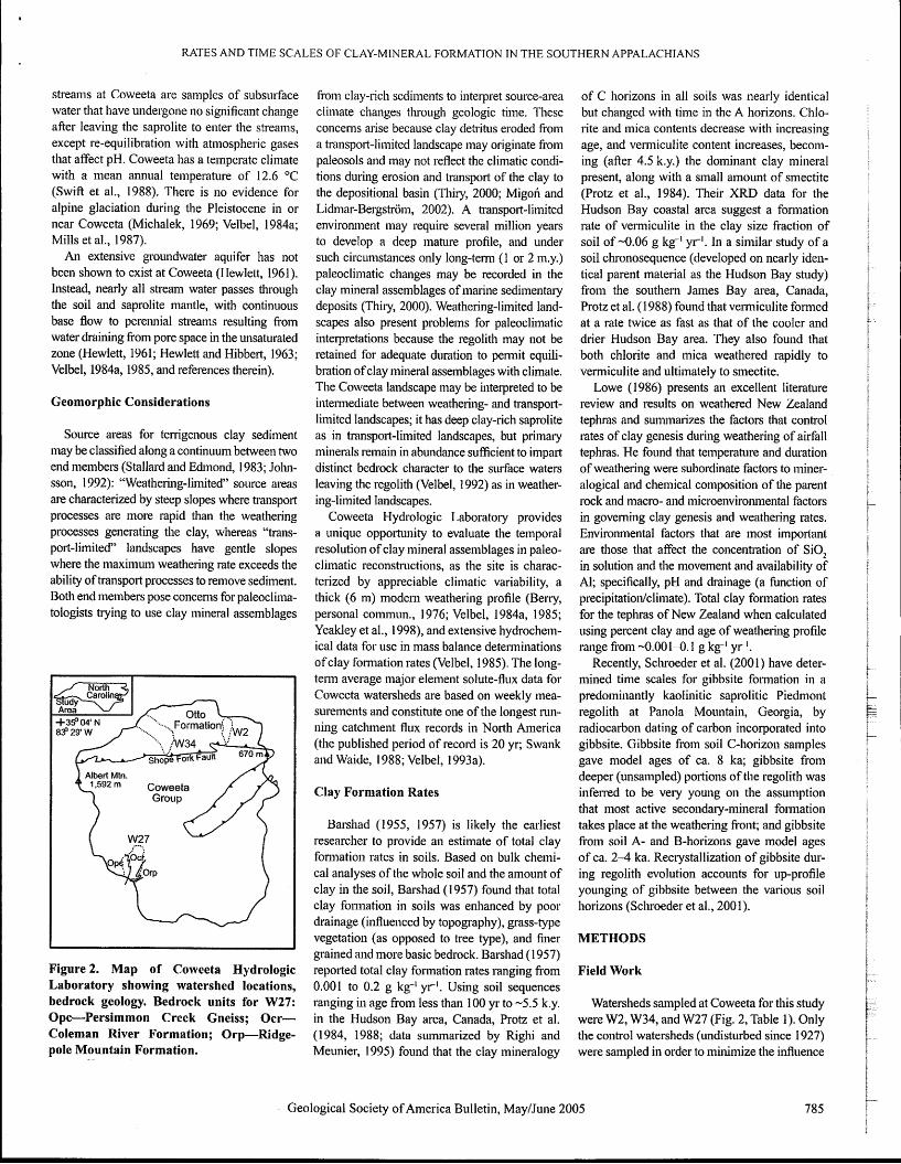
Figure 2. Map of Coweeta Hydrologic Laboratory showing watershed locations, bedrock geology. Bedrock units for W27: Opc-Persimmon Creek Gneiss; Ocr- Coleman River Formation; Orp-Ridge- pole Mountain Formation.
froill clay-iich sedii~lents to interpret source-area cliinate changes tluough geologic time. These concerns arise because clay detsitus eroded fion~ a t~-ansport-lirnited landscape may o~iginate fiom paleosols and may not reflect the climatic condi- tions dui-ing erosion and transpost of the clay to the depositional basin (Thiry, 2000; Migoli and Lidmar-Bergstriiin, 2002). A transport-l imi ted environn~ent may require several million years to develop a deep mature profile, and under such circumstances only long-tern~ (1 or 2 111.y.) paleoclilnatic changes inay be recorded in the clay mineral assemblages of marine sediinentaiy deposits (Thily, 2000). Weathering-limited land- scapes also present probleins for paleocliniatic interpretations because tlie regolith may not be retained for adequate duration to pennit equili- bration of clay mineral assemblages with climate. The Coweeta landscape nlay be interpreted to be internlediate between weatheling- and transport- limited landscapes; it has deep clay-rich saprolite as in transport-limited landscapes, but primary minerals ixinain in abundance sufficient to impart distinct bedrock character to the sillface waters leaving the regolith (Velbel, 1992) as in weather- ing-limited landscapes.
Coweeta Hydrologic Laboratory provides a unique opporttiiiity to evaluate the temporal resolution of clay ~niiieral assemblages in paleo- climatic reconstnictions, as the site is charac- terized by appreciable climatic variability, a thick (6 111) iilodern weathering profile (Berry, personal coinnlun., 1976; Velbel, 1984a, 1985; Yeakley et aI., 1998), and extensive hydrochem- ical data for use in nlass balance determinations of clay forn~ation rates (Velbel, 1985). The long- teetn average major element solute-flux data for Coweeta watersheds are based on weekly mea- suren~ents and constitute one of the longest i-un- ning catchment flux records in North America (the published period of record is 20 yr; Swank and Waide, 1988; Velbel, 1993a).
Clay Formation Rates
Barshad (1955, 1957) is likely the earliest researclier to provide an estimate of total clay fonnation rates in soils. Based on bulk chemi- cal analyses of the whole soil and the amount of clay in the soil, Barshad (1957) found that total clay follilation in soils was eilhatlced by poor drainage (influenced by topography), grass-type vegetation (as opposed to tree type), and finer grained and more basic bedrock. Barsl~ad ( 1 957) reported total clay formation rates ranging from 0.001 to 0.2 g kg-' y r l . Using soil sequences ranging in age from less than 100 yr to -5.5 k.y. in the Hudson Bay area, Canada, Protz et al. (1984, 1988; data summarized by Righi and Meunier, 1995) found that the clay mineralogy
of C horizons in all soils was nearly identical b ~ ~ t changed with time in the A horizons. Chlo- site and mica contents decrease with increasing age, and venniculite content increases, becom- ing (after 4.5 k.y.) the domiiiant clay mineral present, along with a small amount of sinectite (Protz et a]., 1984). Their XRD data for the Hudson Bay coastal area suggest a fonnatioti rate of vernliculite in the clay size fraction of soil of -0.06 g kg-' y r i . I11 a siinilar study of a soil chronoseq~~ence (developed on nearly idell- tical parent inaterial as the Hudson Bay study) from the southern James Bay area, Canada, Protz et al. (1988) found that vei~niculite fom~ed at a rate twice as fast as that of the cooler and drier Hudson Bay area. They also found that both chlorite and mica weathered rapidly to vermiculite and ultimately to sinectite.
Lowe (1 986) presents an excellent literature review and results on weathered New Zealand tephras and sunmal-izes the factors that control i-ates of clay genesis during weathering of airfall tephras. He found that ten~perature and duration of weathering were subordinate factors to miner- alogical and cheinical con~position of the parent rock and macro- and inicroenviro~mental factors 111 governing clay genesis and weathering rates. Environmental factors that are most import,mt are those that affect the concentration of SiO, in solution and the movement and availability of Al; specifically, pH and drainage (a fbnction of precipitation/climate). Total clay fot~nation rates for the teplzras of New Zealand when calculated iising percent clay and age of weatheiiig profile range fioin -0.001-0.1 g k g i yr1.
Recently, Scliroeder et al. (200 1) have deter- mined time scales for gibbsite foimiation in a predoini~iantly kaoliilitic saprolitic Piedniont regolith at Panola Mountain, Georgia, by radiocarbon dating of carbon incoipowted into gibbsite. Gibbsite from soil C-liorizoii samples gave nlodel ages of ca. 8 ka; gibbsite fiom deeper (unsampled) portions of the regolith was infersed to be very young 01.1 the assumption that most active secondaiy-mineral fonnation takes place at the weathering front; and gibbsite fi-om soil A- and B-horizons gave model ages of ca. 2-4 ka. Recrystallizatioi~ of gibbsite dur- ing regolith evolution accounts for up-profile yoi~nging of gibbsite between the various soil horizons (Sclvoeder et al., 200 1).
METHODS
Field Work
Watersheds sampled at Coweeta for this study were W2, W34, and W27 (Fig. 2, Table 1). Only the control watersheds (undisturbed since 1 927) were sampled in order to minimize the influence
Geological Society of Alnerica Bulletin, MayIJune 2005 785
PRICE et al.
of bio~ilass state on the streain ininera1 nutrient budgets, although the biomass component of tlie mass balance has been included in calculations. All watersheds used in this study are covered with inixed iilature hardwoods characterized in geater detail by Swank and Douglass (1977) and Swank and Crossley (1 988).
Streain waters were sampled for REE analyses at tlle weir and filtered in the field using 0.45 p111 pore-size MilliporeTM filters. The filtered streain water was collected in acid-cleaned polypropyl- ene (Nalgene) bottles. The -60 1111 of filtered stream water was acidified with 200 yl of HNO,. The field sampling kits were provided by the aqueous geochelnistry researcli group at Michi- gan State University. The ultra clean salnpling protocols used to sanlple the Coweeta streams were established by this same group and folloiv methods outlined by Niiagu et al. (1993, 1996), Benoit (1 994), Benoit et al. (1 997), Horowitz et al. (1 994, 1996), and Hurley et al. (1 996).
Petrography
Thin sections of bedrock, soil, and saprolite were prepared by statidard methods. Additional bedrock samples were obtained by Bessy (per- sonal conlmun., 1976) during a regolith coiing investigation at Coweeta. All saniples collected as pait of this study were prepared commercial1y by Petrograpliic Illternatioi~al (Choiceland, Sas- katchewan, Canada). Due to tlie friable nature of the saprolite and soil, clear epoxy was used to vacuum impregnate tlie sainples collected i11
cllroine tubes. Grain n~ounts were also prepared for soil samples collected by the Coweeta staff.
X-ray Diffraction
X-ray diffraction (XRD) was used to charac- terize the clay minerals present in the Coweeta regolith. Separatioil of the clay size fraction ( ~ 0 . 2 pin) from regolith samples collected at all levels iii the weathering profile (including bedrock) was perfol-lned by gravity settling, with the clay-size fiaction being separated with a pipette, and the aliquots being filtered onto a 0.45 pin MilliporeTM filter following rapid- suction mounting techniques (production of oriented mounts, also teimed the MilliporeTM Filter Transfer Metliod of Drever [I 9733 and described by Moore and Reynolds [1997]). Four oriented XRD nlounts of each saii~ple were prepared at roo~ll temperature; air dried (naturally occurring exchange ions), potassiurn saturated, n~agnesii~m saturated, and magne- sium sah~rated/ethylene glycolated. After the initial XRD analyses tlie potassiunl-saturated sainpfes were heated to 575 "C and rescanned. Tlze Rigaku Geigerflex XRD (Department of
786 Gec
Geological Sciences at Michigan State Uni- versity) uses CuKu racliatio~~ and is equipped with a nickel foil filter. XRD analyses were co~lducted using divergence, receiving, and anti-scatter slits of 1/2O, 0.3 II-LIII, and 2O, respec- tively, a step size of 0.02' 20, and coii~it tilnes of 20 seconds. Identification of diffractogram peaks followed Brown and Brindley (1984), Wilson ( 1 987), Eslinger and Pevear (1 988), and Moore and Reynolds (1997).
Scanning Electron Microscopy (SEM): Secondary and Backscattered Electron Imaging (BSE)
Polislied thin sections and stubs of Coweeta bedrock and regolith were eitl~er carbon- or gold-coated for exa~nination by SEM and ana- lyzed by energy dispersive X-ray spectroscopy (EDS) for element compositioil. Inlaging and alialyses were perfomled at Micliiga~~ State University's Center for Advanced Microscopy (CAM) using a JEOLVSM-35CF SEM with EDS and BSE capabilities.
Electron Microprobe Phase Analyses (EMPA)
Electroil microprobe analyses of Coweeta bedrock and regolith niinerals in thin section were conlpleted at the University of Michigan's Electron Microbeam Analysis Laboratory (EMAL) using a wavelength dispersive Caineca SX 100 electron microprobe analyzer. Acceler- ating voltage and bean1 cu~~eii t were 15 keV and 10 nA, respectively, and a beam diaineter of 2 pin was used. Calibration standards for Na, Si, Al, Mg, Fe, Mn, Ti, Ca, and K were respectively albite (natural Tiburon), tanzanite (natural), aiidalusite (natural), enstatite (synthetic), fer- rosilite (synthetic), rhodonite (natural Broken Hill), geikielite (natural), tanzanite (natural), and adularia (natural St. Gothard).
Allanite and epidote fonnulae calculated fronl the EMPA data are stoicliiometric and not structural. Structural fornlulae of allanite can only be calculated for nometatnict samples (Ercit, 2002), and structural fo~~nulae for any illinera1 can only be calculated when the EMPA data contain both ferrous and ferric iron. By analogy with allanite and epidote compositions reported by Deer et a]. (1986), the calculated formulae for Coweeta allaiiite likely contain fer- rous and ferlic iron in approximately equal stoi- chioinetries, and the Coweeta epidote has been assigned all ferric iron (Price et al., 2005). The struch~ral fomiula of veriniculite was calculated using a method that assunles that the alumino- silicate layers have not been modified during the transfoi-n~ation of biotite to vemliculite (Velbel, 1984a, 1985; Newman, 1987).
logical Society of America Bulletin, May/June 20
Rare Earth Element Analyses by frlciuctively Coupled P Iasma Mass Spectrometry (ICP-MS)
Rare eal-th elenlent analyses of both stream waters and mineral phases in thin section were performed on a Micromass Platfoml Indi~ctively Coupled Plasma Mass Spectronleter (ICP-MS) at Michigan State University. The REE included in this study are lanthaniim (La), cerium (Ce), neodyiniuin (Nd), gadoliniuln (Gd), dysprosiulll (Dy), and ytterbium (Yb). These six REE were selected based on their relatively high abun- dance (above background) in a prelimina~y scan of Coweeta stream waters. All six of these have been included in the mineral st111ctural1 stoichioi~~etric foi-nlulae; however, only streain flux data for La, Nd, and Dy have bee11 utilized in the inass balance calculations. Stream solu- tions were analyzed by the ICP-MS using a conceiltric nebulizer, and indiuni (In) was used as an intetnal standard. The concentrations (in pg 1111-') were calculated using regression lines with standard solutions.
Laser ablation ICP-MS (LA-ICP-MS) analy- ses were perfonned using a Cetac LSX 200' laser ablation systeln on sample thin sections. LA-ICP-MS provides higll resolution sanlpling capabilities and i~~ultielement high sensitivity (Flyer et al., 1995; Neal et a]., 1995). For all ~nin- erals analyzed (biotite, vermiculite, plagioclase, galllet, epidote, and allanite), tlie bean1 size was 25 pin (using a UV, 266 lull beam), and the pulse rate was 20 Hz, with the exception of the pkyllo- silicates for which a pulse rate of 10 Hz was used. A seduced pulse rate for tlie phyllosilicates was necessaly as the st~-~~ctural water and perfect basal cleavage resulted in a mineral that was suscep- tible to extensive damage at higher pulse rates. LA-ICP-MS and EMPA analyses spots were adjacent to one another, and Ca was used as the intesnal standard for all laser ablation analyses (Flyer et a]., 1995; Longerich et al., 1996). NIST 6 12 glass was used as a calibration standard and results were obtained in pg g1 following ineth- ods outliiied by Norman et al. (1996).
Watershed Mass Balance Methods
Watershed geochenlical inass balance meth- ods are considered tlie no st accurate meails of quantifying weathering reactions in nature and elenlental transfers at the Earth's su~face (Clayton, 1979). Mass balance methods fol- low those of Pluin~ner and Back (1980), Velbel (1985, 1986a; Taylor and Velbel, 199l), and Drever (1997a), with rates of clay mineral gen- esis determined following methods outlined by Cleaves et al. (1 970), Finley and Drever (I 997), and recently by Bowser and Jones (2002, and
8
RATES AND TIME SCALES OF CLAY-MINERAL FORMATION IN THE SOUTHERN APPALACHIANS
references therein). For mass balance modeling miculite, kaolinite, and gibbsite. Prima~y-mineral never been measured. Nevertheless, the atmo- of watersheds, input fluxes include precipita- tion, biolnass if degrading, and mineral weatli- ering reactions, while outp~rt fluxes include evapotranspiration, bio~zlass if aggrading, clay genesis, and stream discharge. Analytical techniques outlined above have permitted deter- nlination of clay co~npositioiz and provide the stoichio~netries of clay genesis. These data have been co~izbiiled with published liydrological and hydrogeochen~ical data (i.e., Swift et al., 1 988; Swailk and Waide, 1988). Ni~trieilt data for Coweeta bionlass is from Day and Moilk (1 977) and Boring et aI. (1981). Chloride is approxi- mately in balance in all watersheds (Swank and Douglass, 1977), and hence groundwater stor- age or leakage is not of coiicem.
Following matrix algebraic methods, to per- fornz solute-based iiiass balance calculations
alteration textures and reactant-product texhiral 1-elations observed by optical petrography and SEM are similar to those previously repoi-ted for plagioclase (Velbel, 1983, 1986b), biotite (Velbel, 1984~1, 1985), and galmet (Velbel, 1984b, 1993b) froin Coweeta; new I-esults for allanite are reported elsewlzere (Price et al., 2005). Major and rare eai-th eleme~lt analyses for ail minerals used in lnass balance calculations of this study are provided in Tables DRl and DW1, with stn~c- tural alzd stoichioiiletric fo~inulae provided in Table DR3. For kaolinite and gibbsite, standard fornlulae are reported, as these ~ninerals liave negligible substitution and do not appreciably host stnichlral REE (e.g., Nesbitt, 1979; Duddy, 1980; Bust, 1989; Braun et a]., 1993; Fiiiley and Drever, 1997). The mineral compositio~is of the Coleman River Foiinatio~l wese clioseii
spheric conh-ibution of REE to Coweeta strean1 watel-s is believed to be negligible. In thick (greater than several meters), unpollrtted weath- ering profiles, the dissolved REE distribiition in strean1 waters will be controlled by bedrock weatliesing, and at~nosplleric REE cotltributions will not be detectable (Goldstein and Jacobsen, 1988; Elderfield et a]., 1990; Bratin et al., 1998; Tricca et al., 1999; Probst et a]., 2000; Aubert et al., 2001, 2002). Because Coweeta contains a thick regolith (on average 6 1x1, but up to 1 8 in; Beny, peisonal co~nnlu~z., 1 976; Ciampoize, 1995; Yeakley et al., 1998), the REE iitput to nat- ural soil and surface waters from illinera1 weatli- eiing sho~~ld overwhelm atmospheric inputs.
Miireralogic Sorrrces atid Siiiks of Rare Eartit Elenletrts
tlze lzu~nber of unknowns (i.e., the weathering for the mass balance because it is tlie dominant Allanite is the only accessory mineral at rates or iiiass transfer coefficients) must equal litlzostratigraphic unit in W27, especially at the Coweeta tliat contains REE, is weathering, and the number of so l~~te mass balance equations wanner lower elevations where weathering is is present in significant quantities in unweath- (i.e., the nun~ber of elenlents for which stream most intense in tlie watershed (Fig. 2). The matri- ered bedrock (Price et al., 2005). The abundance solute fluxes are available). Therefore, the inass balance calctllations were represented as a grand matrix of simultaneous equations (Velbel, 1 986a). Each colu~~zn in the ~natrix represents the stoicliiometry of a ~ilineral involved in weather- ing, and each row represents an element for which net solute efflux data (output minus iiipnt) has been obtained. The grand nlatrix multiplied by the mineral weatliering/fo~~izatioti rates (the u ~ h ~ o w n s in a colu~~ul vector) is then equaI to
ces of stoicl~ioi~~etric coefficients are provided in Tables DR4 and DR5. Table DR6 contains the major and rare ele~nent analyses and fluxes of stream waters froin W2, W34, and W27.
Watershed Mass Balance and Rare Earth Elements
Rare east11 eleinents are included because they are relatively mobile during weathering
and ubiquity of allanite have been obseived pet- rographically. The case for high weatlierability of allanite is widespread in the literature, as it k-
iizay be co~npletely dissolved below the weath- ering fiont (e.g., Goldich, 1938; Meintzer, 198 1 ; Banfield and Eggleton, 1989; Brau~i et al., 1993;
f
Braun and Pagel, 1994; Harlavan and Erel, + I
2002; Price et al., 2005). Apatite is routinely invoked as being tlie source of REE found in interstitial regolith waters, groundwaters, and ,
tlie column vector containing tlze net solute flux as they are not contailzed in secoildary nii11er- suiface waters (e.g., Banfield and Eggleton, data. For ally eleinent included in the solute flux, als (with the exception of vern~iculite discussed 1989; Marker and De Oliveira, 1990; Braun every phase undergoing weatheiii~g that contains below) that relizain stable during progressive and Pagel, 1994; van der Weijden and van der that element i~tust be included in the inass bal- weathering (e.g., Nesbitt, 1979; Cramer and Weijden, 1995; Braun et al., 1993, 1998; T~icca ailce inatsix. In older to obtain equal numbers Nesbitt, 1983; Banfield and Eggleton, 1989; et al., 1999; Aubert et al., 2001,2002; Harlavan of uldu~owns aiid equations, REE have been Braun et a]., 1990, 1993, 1998 and references and Erel, 2002). At Coweeta, I~owevel; apatite is included in the calculations of this study (specifi- tllerein; Marker and De Oliveira, 1990; Braun so scarce that none was encountered during the cally La, Nd, and Dy). The algebraic calculations and Pagel, 1994; van der Weijden and van der point counting of bedrock thin sections. of this study were perfoilned using MATLAB'& Weijden, 1995; Koppi et al., 1996; Nesbitt and 111 Coweeta soil, vern~iculite is the only sec- software. This investigation is the first time that Markovics, 1997). The only exception is Ce3', ondaty mineral colztaining appreciable ailiou~lts trace elements have been included in inass bal- wlzich oxidizes to Ce4+ in the weathering envi- of REE. The REE concentration in veni-~iculite ance methods. The REE are an ideal cltoice to roiulient and precipitates as cerianite (CeO,), has been quantified by ICP-MS aiid is included include in the inass balance model, as allaizite is ill the mass balance calculatio~is (Tables DR4 an inzpol-tant weathering phase at Coweeta (Price Atirtospherk Itry~ts of Rnre EnrtIt Eletli ents and DR5). Exclusio~i of the REE abundances et al., 2005) and is also a substantial REE host At Coweeta, atmospheric major element inputs in venniculite yields geochemically rmseason- (Meintzer, 198 1 ; Braun and Pagel, 1994; B~-aun have been 11ieasu1-ed and subtracted from the able nzass balance results. Previous studies et al., 1993, 1998; Harlavan and Erel, 2002; stream solute flux data, yielding a net stream Aux liave demonstrated that kaolinite (Nesbitt, 1979; Ercit, 2002). Ful-ther details on the niass balailce value that reflects oiily the tnineralogic contsibu- Driddy, 1980; Braun et al., 1993), gibbsite, and methods a1-e beyond the scope of this paper. tioils of nlajor elements to ssu~face water (Swank goethite (Braun et al., 1993) do not host appre-
and Waide, 1988, their table 4.1 1). However, ciable abundances of structural REE, but prob- RESULTS REE concentsations in precipitation at Coweeta ably pa~ticipate in cation exchange in relatively
Mineral Compositions or anywhere in the southeix Appalachians have s~nall ways (e.g., Coppill et al., 2002). 1 . ~
Alirmtirtirrtt nnd Rnre Enrtli Eieittertt Stt8ennr yl vvVLILll\lri~ig at Coweeta
'GSA Data Repository item 2005083, Tables DRl-6, is available on the Web at http://mw.geosociety.or~ F1rL'es
are plagioclase, biotite, garnet, and allailite. pubs/ft2~05,h~nl~~eauestslnava(sobeserlttoediting~ Like major elements, REEs show seasonal t I --
Secondaiy mine~-als present at Coweeta are ves- geosociety.org. and ten~poral variations in streani waters (Ingri I
Geological Society of Anlerica Bulletin, MayIJune 2005

PRICE et al.
et al., 2000). In order to average out this vari- ability, a minimuill seven year period of record of weekly stream water sampling and analysis is needed (Likens and Bor~l~a~m, 1995). The Coweeta inajor element long-term average solute-flux data used in this study is based on a 20 yr period of record (Swank and Waide, 1988; Velbel, 1993a). However, the A1 and REE streain water chemistry used is a one-time sample, collected 011 May 22, 2002. In order to calculate an approxiinate long-tell average A1 and REE solute-flux from the single sample episode, SiO, was included with the A1 and REE analyses. The ratio of the long-te1-111 SiO, flux (Swank and Waide, 1988) to the one-time May 2002 SiO, flux was tl~eil used to convert the one-time AI and REE stream solute con- centrations to approximate long-tenn averages (Table DR6). Silica was used because it is negligibly influenced by biomass, and, despite relatively small abundances being incoi-porated illto kaolinite, it represents the elelnent with the greatest loss from the weatl~ering profile (e.g., Bowser and Jones, 2002).
Primary Mineral Weathering Rates and Secondary Mineral Formation Rates
The results of the mass balance calculations are presented in Table 2. Watersheds 2 and 34 differ only by climate and are nearly identical with respect to bedrock, aspect, vegetation, weathering histo~y, and being undisturbed con- tsol watersheds (Velbel, 1993a). Watershed 27 is significantly cooler, with higher precipitation (Table 1) than either W2 or W34. For purposes of comparison, inass balance calculations using REE have also been performed on W27; a water- shed underlain by three lithostratigraphic units (Fig. 2), all of which are less reactive than the rocks of the Otto For~nation (Velbel, 1984a).
Nine solutes (Table DR6) are available for inass balance calculations, although the wates- sheds only have eight imknowns; i.e., the seven wineral weathering/dissol~~tioil/fo~mation rates plus the bota~~ical uptake/deg~*adation rate. The solutes used in the inass balance calculations are the six inajor ele~nents, as well as Dy and La for W2 and W34 (Table DR4) and La and Nd for W27 (Table DR5). Lanthanum was chosen for all watersheds because it has the highest con- centrations in stream waters. Dysprosiunl was iilcluded in W2 and W34 calculations because it occurs in both allanite and gasnet. By leaving all elelllent stoichion~etries positive in Tables DR4 and DR5 and using positive streain flux values, the calculated rates of nli~lerals being destroyed will be positive, and rates of minerals forming will be negative (Table 2). If no REE content for gai-net was included in the W2 and W34 inass
balance calculations, geochemically unreason- able results were obtained (e.g., a negative garnet weathering rate). Geocheinically unrea- sonable results were also obtained if Dy was included in the W27 calculations. Again, a nega- tive garnet weathering rate was obtained.
The significant figures of the rates in Table 2 are impo~-tant. The REE streain flux data have been lilnited to one significant figure because the ICP-MS calibration lines were dominated by standards with concentrations higher than that of the solutes. The only mineral that has a rate calculated exclusively from REE solute fluxes is allanite, and appl-opriately the allanite weathering rate is reported to one significant figure. Galnet too has a weathering rate influ- enced by Dy, and appropriately the galllet rate will be reported to one significant figure. All of the otl~er minerals, however, have weathering or foilnatioil rates calculated from major element fluxes; the biotite and ve~lniculite rates are cal- culated froin K, plagioclase is calculated from Na, and kaolinite and gibbsite are calculated fioin Si and Al. Therefore, three (or two for rates in tens of lnol ha-' y r i ) significant figures are reported for the weathering/for~uation rates of these minerals.
The differences in inineral weathering1 fonnation rates between W2 and W34 reflect the difference in cliinate as these two watersheds are identical in bedrock and aspect. Watershed 2 receives relatively less rainfall and experiences wariner temperatures than does W34 (Table 1). The inineral weatl~eringlfomation rates of W27, however, reflect less cl~emically I-eactive bedrock and a wetter and cooler climate relative to the bedrock and cli~natic coilditioils of either W2 or W34 (Table I).
DISCUSSION
Response Times for Watersheds at Coweeta Hydrologic Laboratory
The ultimate goal of obtaining the clay min- eral kinetic data above is to pennit calculation of clay inineral respoilse times. That is, at the current clay fo~~nation rates for a given water- shed, how ~nuch time is required to achieve a 5% (or 50 g kg-') relative change in segolith clay mineral abundance. The choice of 5% reflects the minimum changes in relative clay abundance that can be detected by changes in XRD peak intensities (e.g., Brown and Brindley, 1984; Moore and Reynolds, 1997).
The time required to achieve a change of 50 g kg-' in clay abundance in the Coweeta water- sheds investigated is reported in Table 3 and is based on the rates calculated using inass bal- ance methods. Table 3 shows that it would take
TABLE 2. RESULTS OF THE MASS BALANCE CALCULATIONS
Phase WeatheringIFormation Rate (mol ha-' y r i ) Watershed 2 Watershed 34 Watershed 27
Allanite 30 7 10 Plagioclase 485 435 243 Garnet 40 40 100 Biotite 433 142 11 2 Vermiculite . -308 -38 -69 Kaolinite -304 -1 50 -4 Gibbsite -288 -51 3 -546
Note: A positive rate indicates weathering of a mineral; a higher rate indicates more rapid destruction. A negative rate indicates formation of a mineral; the more negative the rate the faster the formation.
TABLE 3. TIME REQUIRED FOR A 5% (50 G KG-') CHANGE IN REGOLITH CLAY ABUNDANCE
Watershed Kaolinite Gibbsite Vermiculite (years) (years) (years)
2 81,000 280,000 47,000 34 160,000 160,000 380,000 27 150,000 21 0,000
Note: Response times based on calculated rates in Coweeta watersheds.
788 Geological Society of America Bulletin, May/June 2005
8 1,000 yr to increase the kaolinite abt~ndance in W2 by 5% at the current kaolinite foi~na- tioil rates. The same increase in W34 would take longer (160,000 yr). The same relation- ship exists for ver~niculite in W2 and W34, but a gibbsite increase of 50 g kg-' is inore rapid in W34 (160,000 yr) than W2 (280,000 yr). The relatively low kaolinite fom~ation rate of W27 (Table 2) has not been used to calculate clay response times. Altl~ough the kaolii~ite foi-nlation rate for W27 is believed to be a robust value, it is not believed to be typical of no st southern Appalachian weathering profiles. The W27 gibbsite and vei~niculite response times are comparable to those of W34. The response times (Table 3) are clearly too long to pernlit Coweeta clay mineral assenlblages to reequili- brate with clinlate during the Holocene (since 12.5 ka for the southeasteix United States; Del- coilst and Delcourt, 1985).
Clay Formation Rates in the Southern Appalachians
In order to calculate the time needed to fonn measured regolith clay abundances, additional weatllering profile infoimation is needed. Con- versioi~ of fluxed-based watershed clay genesis/ dissolution rates in lnol ha-' y r ' to g kg-' y r l is easily accomplished, with the rate in g kg-' y r ' then being used to calculate the time needed to produce the ~neasured clay abundance. However, clay abundances in the literature are
RATES AND TIME SCALES OF CLAY-MINERAL FORMATION IN THE SOUTHERN APPALACHIANS
TABLE 4. DATA FOR THE CALCULATED REPRESENTATIVE COWEETA REGOLITH
Horizon W2 Horizon thickness Bulk density Calculated weighted (cm)+* (g ~ r n - ~ ) + profile bulk density
(9 ~ m - ~ )
A 11 1.30 B 46 1.54 2.11 C 543 2.17
+Berry (1 976, personal comrnun.). *Yeakley et al. (1998).
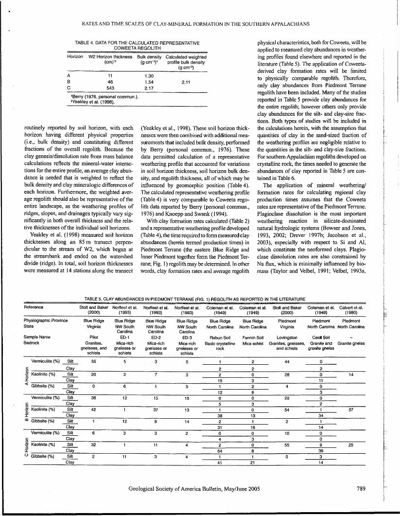
routinely reported by soil horizon, with each horizon having different physical properties (i.e., bulk density) and constituting different fractions of the overall regolith. Because the clay genesisldissolution rate froin mass balance calculations reflects the mineral-water interac- tions for the entire profile, an average clay abun- dance is needed that is weighted to reflect the bulk density and clay tnineralogic differences of each horizon. Furthennore, the weighted aver- age regolith should also be representative of the entire landscape, as the weathering profiles of ridges, slopes, and drainages typically vaiy sig- nificantly in both overall thickness and the rela- tive thicknesses of the individual soil horizons.
Yeakley et al. (1998) measured soil horizon thicknesses along an 85 m transect perpen- dicular to the stream of W2, which began at the streainbaitlk and ended on the watershed divide (ridge). In total, soil horizon thicknesses were measured at 14 stations along the transect
(Yeakley et al., 1998). These soil horizon thick- nesses were then combined with additional mea- surements that included bulk density, performed by Belly (personal corninun., 1976). These data permitted calculation of a repi-esentative weathering profile that accounted for variations in soil horizon thickness, soil horizon bulk den- sity, and regolith thickness, all of which may be influenced by geomorphic position (Table 4). The calculated representative weathering profile (Table 4) is very cornparable to Coweeta rego- lith data reported by Beny (personal commun., 1974) and Knoepp and Swank (1 994).
With clay foltllation rates calculated (Table 2) and a representative weathering profile developed (Table 4), the time required to form measured clay ab~indances (herein tenned production times) in Pied~nont Terrane (the eastern Blue Ridge and h e r Piedmont together form the Piedinont Ter- raile; Fig. 1) regolith may be deteimined. In other words, clay foiillation rates and average regolith
physical charactei-istics, both for Coweeta, will be applied to measured clay abundances in weather- ing profiles found elsewhere and reported in the literature (Table 5). The application of Coweeta- deiived clay fonnation lates will be Ii~nited to physically coinparable regolith. Therefore, only clay abundances from P iedrnont Teirane regolith have been included. Many of the studies reported in Table 5 provide clay abundances for the entire regolith; however others only provide clay abundances for the silt- and clay-size frac- tions. Both types of studies will be included in the calculations herein, with the assuinption that quantities of clay in the sand-sized fraction of the weatheling profiles are negligible relative to the quantities in the silt- and clay-size fractions. For southern Appalachian regoliths developed on crystalline rock, the times needed to generate the abundances of clay reported in Table 5 are con- tained in Table 6.
The application of mineral weathering1 fonnation rates for calculating regional clay production times assumes that the Coweeta rates are representative of the Piedinont Terrane. Plagioclase dissolution is the ~nost important weathering reaction in silicate-dominated natural hydrologic systems (Bowser and Jones, 1993, 2002; Drever 1997b; Jacobson et al., 2003), especially with respect to Si and Al, which constitute the neofonned clays. Plagio- clase dissolution rates are also constrained by Na flux, which is inini~nally influenced by bio- mass (Taylor and Velbel, 1991; Velbel, 1993a,
TABLE 5. CLAY ABUNDANCES IN PIEDMONTTERRANE (FIG. 1) REGOLITH AS REPORTED IN THE LITERATURE
Reference Stolt and Baker Norfleet et al. Norfleet et ai. Norfleet et al. Coleman et al. Coleman et al. Stdt and Baker Coleman et al. Calvert et at. (2000) (1 993) (1 993) (1 993) (1 949) (1 949) (2000) (1 949) (1 980)
Physiographic Province Blue Ridge Blue Ridge Blue Ridge Blue Ridge Blue Ridge Blue Ridge Piedmont Piedmont Piedmont State
Sample Name
Virginia NW South NW South NW South North Carolina North Carolina Virginia North Carolina North Carolina Carolina Carolina Carolina
Pilot ED-1 ED-2 ED-3 Rabun Soil Fannin Soil Lovinaston Cecil Soil - Bedrock Granites, Mica-rich Mica-rich Mica-rich Basic crystalline Mica schist Granites, gneisses, Granite and Granite gneiss
gneisses, and gneisses or gneisses or gneisses or rock and schists granite gneiss schists schists schists schists
Vermiculite (%) Silt 55 5 3 5 1 2 44 0
c Clay 2 2 2
.$ Kaolinite (%) Silt 20 2 7 3 2 0 28 0 14 I Clav 16 '3 11 ."
Gibbsite (%) 9 1 ; -
0 6 1 5 1 2 4 0 Clay 12 6 3
Vermiculite (%) Silt 36 12 15 15 0 0 22 0 c Clay 5 3 2 .! Kaolinite (%) Silt 42 1 37 13 I 0 54 1 37 i Clay 38 13 34
Gibbsite (%) Silt 1 12 8 14 2 1 2 1 Clay 31 16 14
Vermiculite (Oh) Silt 6 3 3 2 0 0 10 0 c Clay 4 3 0 .2 Kaolinite (%) Silt 32 1 11 4 2 0 55 9 25 2 Clay 64 8 39 O Gibbsite (%) Silt 2 11 3 4 1 1 0 3
Clay 41 21 14
Geological Society of America Bulletin, MayIJune 2005 789

PRICE et al.
1995). Therefore, plagioclase dissolution rates may be used to assess the regional representativeness of Coweeta clay fo~~ila- tion rates. Table 7 contains plagioclase dis- solutio~z rates calculated as part of this study, as well as fro111 other central and so~~ther~l Appalachian watersheds as reported in the literature. Fro~n Table 7 it is evident that the Coweeta plagioclase dissolution rates fall near the mean of sout11e1-n and ceiitral Appalachian plagioclase dissolution rates. This observation supports the regional rep- resentativeness of the Coweeta mass balance calculations and their use in calculating clay production tinles for the Piedmont Terrane.
The clay production times reported in Table G are based on a representative weath- ering profile and reflect clay fosnlation rates calculated for present-day conditio~is at Coweeta. The production times of clay min- eral assenlblages range from 2 k . ~ . to 2 m.y. with mean values ranging from 50 k.y. to 1 n1.y. Based on tlie present-day weathering rates of p~iinary minerals, Velbel (1984a, 1985) reports a Coweeta saprolite residence time of -100 k.y. This residence time falls within the range of mean clay production times for regolith of the Pied~nont Tewane.
Schroeder et al. (200 1) dete~~nined time scales for gibbsite fol~nation in a predomi- nantly kaolinitic saprolitic Appalachian Pied- mont regolith at Panola Mountain, Geosgia, by radiocarbon dating of carbon incorporated into gibbsite. Kaolinite, the dorninant clay niineral, cannot be dated by the salne ~neth- ods (Schroeder and Melear, 1999). Gibbsite model ages among different horizons in this Piedmont soil range froin 2 to 8 ka (Sclu-oe- der et at., 2001). Cosmogenic nuclide sys- tematics of quartz in the Panola Mountaill soil suggest a residence time of ca. 90 to125 ka for tlie upper 2 In of this Piedn~ont ridgecrest regolith (Sch-oeder et al., 2001). This rego- lith residence time compares well with the regolith residence time (ca. 140-1 60 ka) estimated for Coweeta saprolite fi-0111 solute mass bala~ice by Velbel ( 1 985). Time scales for overall developn~ent of saprolitic regolit11 appear broadly similar (order of 100 ka) at both Coweeta and Paslola Mountain despite ~nethodological differences in detemiining the time scales. Coweeta (e.g., Table 2) arid Panola Mountain (Sclwoeder et al., 2001) results are also similar in that both imply rapid fornlation of gibbsite during the Holo- cene. The overall gibbsite invento~y appears to have fortiied on shorter time scales at Panola Mountaul than at Coweeta (Table 3), other Blue Ridge regoliths (Table 6), or no st other Appalacllian Piedmont regoliths
Geological Society of America Bulletin, May/June 2005

U T E S AND TIME SCALES OF CLAY-MINERAL FORMATION IN THE SOUTHERN APPALACHIANS
TABLE 7. COMPARISON OF COWEETA PLAGIOCLASE DISSOLUTION RATES WITH SOUTHERN AND CENTRAL APPALACHIAN PLAGIOCLASE DISSOLUTION RATES REPORTED IN THE LITERATURE
Reference Location
O'Brien et al. (1997) South Fork Brokenback Run, Virginia
O'Brien et al. (1997) Hauver Branch, Maryland
O'Brien et al. (1 997) Fishing Creek Tributary, Maryland
Furman et al. (1998) Shaver Hollow, Virginia
Furman et a/. (1998) White Oak Run, Virginia
Furman et al. (1 998) Deep Run, Virginia
White et a!. (2002) Panola Mountain, Georgia Cleaves et al. (1 970) Pond Branch, Maryland
O'Brien et al. (1997) Mill Run, Virginia O'Brien et al. (1997) Shelter Run, Virginia This study W2
W34 W27
Mean Minimum
-- -
Physiographic Province
Bedrock Reported composition
Blue Ridge
Blue Ridge
Blue Ridge
Blue Ridge
Blue Ridge
Blue Ridge
Piedmont Piedmont
Valley and Ridge Valley and Ridge
Blue Ridge
Old Rag Granite
Catoctin Formation Metabasalt
Catoctin Formation Metabasalt
Pedlar Granodiorite with Catoctin Basalt Dikes
Chilhowee Metasedimentary Sequence
Chilhowee Metasedimentary Sequence
Panola Granite Lower Schist Member of the
Wissahickon Formation Massanutten Sandstone Massanutten Sandstone
Otto Formation Otto Formation Coweeta Group
Rate (mol ha-' yrl)
666
Note: The Coweeta rates are near the mean for southern and central Appalachian plagioclase dissolution rates.
(Table 6). Howevel; Holocene time scales for gibbsite foi-mation (similar to those of Schroeder et al., 2001) are infei-red fiom our niass balance approach for the Lovingston soil on Virginia Piedmo~it granites, schists, aiid g~ieisses (Stolt and Baker, 2000). Additional work on dating, niass balaiice, and landscape evolution at a nuni- ber of sites wor~ld provide a stronger basis for further con~parisons.
Tlie influeilce of periglacial cliniates on the cliemical weatliering of Appalachian csystal- line bedrock lias been discussed by Cleaves (1 993). Usiiig an isovolumetric weathering model, he argues that reduced soil CO, and decreased groundwater moving past tlie ieatli- ering fi-ont during periglacial times would result in an average rate of saprolitization over the last nlillion years being as little as 24% of that of the present. If Cleaves (1 993) is correct, then esti~iiates for the mean age or residence time of the saprolite at Coweeta, clay-iniiieral response ti~nes clay mineral at Coweeta, and clay-mineral production times for saprolitjc regolith in the Piedniont Teiraiie (all estimated here using short-term Coweeta weatliering and clay-genesis rates) are all as much as a factor of four longer tlian the values presented here.
Since the Middle Pleistoceile, episodes of cold climates have beell interspersed witli inter- glacial paleoclimates that were wanner tlian the present (Einiliani, 1972; Bowen, 1979; Clark, 1993; Winograd et al., 1997; Bwdley, 1999). Post-Middle Pliocene glacial-interglacial oscil-
lations occurred on time scales of -100 k.y. (Winopd et al., 1997, aiid references therein). Based on the clay production times (Table 6), the present-day mineral abuiidances in ally Coweeta weathering profile reflect the "average" climate that has occuired over the last -500 k.y.
Even under present-day (interglacial) condi- tions favorable for cheinical weathering and clay-mineral fonnation in tlie southern Appala- chians, tlie time scales for foi~iiing clay n~iizerals by weathering are long relative to the time scales of kiiowii glacial-interglacial clirnatic variation. If rates of weathering and clay fo~mation in the southeili Appalachians during northe111 hemisphere glacial episodes were slower than at present, then the time scales for clay-mineral fonnation are even longec In niost saprolitic regoliths of tlie sout1ie1-n Appalachians, clay minerals do not fonn by weathering sufficiently rapidly for regolith clay-n~ineral assemblages to be closely adjirsted to cli~iiatic fluctuations witli time scales shorter than hundreds of thousands of years. To tlie extent that saprolitic regolith in tlie soutlie~m Al>palacliians resembles the deep weathering profiles that dominate inucli of Earth's conti~lental surfice (e.g., Nalion, 199 I), si~nilar coiisideratioiis of time scale iilay apply elsewhere as well.
Clay-mineral assemblages in saprolitic regoliths time-average (or integrate over time) clay accumulation over time scales that include wide variations in climate. Eroded sediiilents derived froin such regoliths sample
this time-integrated clay-il~iiieral assemblage. The sedimentary record of paleoeiiviroii~iieiital change as preserved in detrital clay miiierals cannot have a finer temporal resolution tlian tlie source regolith. Modeni-day weathering and clay fonnation rates in the soutlieni Appa- lacliialls, the abuildances of clay in southern Appalachian saprolitic regoliths, aiid the time scales of ilortherii hemisphere glacial-inter- glacial ciiiiiate fluchlations, all co~nbiile to suppot-t Thiry's (2000) assessmelit that tlie best teniporai resolution attainable from tlie niariiie sedimentary record of teirigenous detrital clay minerals is on the order of 1-2 m.y.
CONCLUSIONS
Clay mineral fomlation rates have bee11 cal- culated using watershed mass balance methods at the Coweeta Hydrologic Laboratoiy located in western North Carolina. The illass balance calcrilations included rare earth elemeizts (REE), which is funda~nentally differelit from previous shidies perfonned at Coweeta or elsewhere. Tlie piiiiary advantage of using additional elenleiits such as tlie rare earths is that a larger number of equations can be constntcted, allowing deter- mination of a larger number of unluiowns. Tliis sih~atioii does not always exist in mass balance calcu1ations.
Coweeta is an ideal locality to pel-fonn such a study, because it is ail iiltei~nediate landscape between weathering-limited and transpoi-ted-
Geological Society of America Bulletin, May/June 2005 79 1

Iinlited end inernbers. The sates have been calculated for thee watersheds, two of which only vary by cliniate (W2 and W34), and a third (W27) that varies fiom the other two by both clinlate and lithology. By calculating pres- en t-day nlineral wea thering/fonnation rates, the rates could be directly coi-related with the lnodesn climate.
Based on the present-day clay formation rates determined by mass balance methods for Coweeta, detectable cllanges in relative clay mineral abundance (i.e., 50 g kg-' using XRD detection limit) occur on time scales of tens of thousands to hundreds of thousands of years. Such time scales are comparable to the d~uration of glacial-interglacial oscillations (- 100 k.y.). As a result, clay mineral assem- blages in the sedinlentary recol-d at best reflect long-term (tens of thousands to hundreds of thousands of years) average cli~nate changes.
Clay production times in Piedinont Ter- rane regolith have been calculated using clay fom~ation rates for present-day coi~ditions at Coweeta and are based on a representative Coweeta weathering profile. The production times of clay mineral asseinblages range fi-0111 2 k.y. to 2 my., with mean values ranging from 50 k.y. to 1 113.y. Certainly, the clay ~nineral assemblages present in the Coweeta regolith today have not equilibrated with the modern Holocene interglacial climate. Therefore, the present-day clay illinera1 abundances and asseinblages in any Piedinont Terrane weather- ing profile reflect an "average" clin~ate that has occuired over the last -2 k.y. to 2 my.
Marine sedinlents derived from saprolitic regoliths cannot have a finer tenlporal resolu- tion of paleoenviron~nental change than the source regolith. The present-day detectable changes in relative clay ~nineral abundance calculated for the southern Appalachians and the time scales of 1101-thern hemisphere glacial- interglacial cli~nate fluctuations both co~nbine to support Tl~iry's (2000) assessnlent that the best tenlporal resolution attainable fi-om the marine detrital clay sedimentary record is on the order of 1-2 1n.y.
ACKNOWLEDGMENTS
The authors wish to thank Associate Editor Chris- tian France-Lanord and reviewers Arthur White and Arne-Marie Ka~yoff for their co~mnents and sug- gestions, which greatly enhanced the quality of this manuscript. Thanks, too, to the Coweeta Hydrological Laboratory staff, especially Wayne Swank and Jennifer Knoepy, who provided assistance during field activi- ties. David Szymanski and Mesedith Lindeman also deserve thanks for their help with stream water sam- pling and analyses. Brian Teppen and Randy Schaetzl provided helpfill and insightful coii>ments during manuscript prepasation. Funding for this project was
PRICE et al.
partially provided by a Grant-in-Aid of'Researcl1 from Sigma Xi, The Scientific Research Society, Michigan Space Grant Consoi-tium Graduate Fellowship, and Clay Minerals Society Student Grant.
REFERENCES CITED
Aobert, D., Stille, P., and Probst, A., 2001, REE fraction- ation during granite weathering and removal by waters and suspended loads: Sr and Nd isotopic evidence: Geochimica ct Cosmocliin~ica Acta, v. 65, p. 387406, doi: 10.101 6/S00 16-7037(00)00546-9.
Aubert, D., Stille, P., Probst, A., Gauthier-Lafaye, F., Pource- lot, L., and Del Nero, M., 2002, Characterization and migsation of attnospheric REE in soils atid surface waters: Geochimica et Cosniochimica Acta, v. 66, p. 3339-3350, doi: 10.1016/S0016-7037(02)00913-4.
Banfield, J.F., and Eggleton, R.A., 1989, Apatite replace- ment and rare earth mobilization, fractionation, and fixation during weatlie~ing: Clays and Clay Minerals, V. 37, p. 113-127.
Barshad, I., 1955, Soil Development, iri Bear, F.E., ed., Chemistry of the Soil: New York, Reinhold Publishing Corporation, p. 1-52.
Barshad, I., 1957, Factors affecting clay formation, in Pro- ceedings of the 6th National Conference on Clays and Clay Minesals: Washington, D.C., National Academy of Sciences-National Researcll Council, p. 1 10-132.
Benoit, G., 1994, Clean technique nieasurenietlt of Pb, Ag, and Cd in fresl~water: A redefinition of metal pollit- tion: Environmental Science & Technology, v. 28, p. 1987-1 991.
Benoit, G., Hunter, K.S., and Rozan, T.F., 1997, Sources of trace metal containiliation artifacts during collection, liandling, and analysis of freshwaters: Analytical Chem- istry, v. 69, p. 1006101 I, doi: 10.102 llAC960798Y.
Biscaye, P.E., 1965, Mineralogy and sedimentation of recent deep-sea clay in tlie Atlantic Ocean and adjacent seas and oceans: Geological Society of America Bulletin, V. 76, p. 803-832.
Boring, L.R., Monk, C.D., and Swank, W.T., 198 1, Early regeneration of a clear-cut southern Appalachian for- est: Ecology, v. 62, p. 1244-1253.
Bowen, D.Q., 1979, Glaciations past and future: The Geo- graphical Magazine, v. 52, p. 62-67.
Bowser, C.J., and Jones, B.F., 1993, Mass balances of natu- ral water: Silicate dissolution, clays, and the calciu~n probletn, in Biogeo~non Syloposiu~n on Ecosystem Behavior: Evaluation of Integrated Monitoring in Small Catchments: Prague, Czech Republic, Czech Geological Survey, p. 30-3 1.
Bowser, C.J., and Jones, B.F., 2002, Mineralogic controls on the coniposition of natural waters doniinated by silicate hydrolysis: Anierican Jounial of Science, v. 32, p. 582-662.
Bradley, R.S., 1999, Paleoclimatology: Reconstn~cting Climates of the Quaternary, 2nd Ed., Volutne 68 of the hiternational Geophysics Series: New York, Academic Press, 6 13 p.
Bmim, J.-J., and Pagel, M., 1994, Geochemical and min- eralogic behavior of REE, Th, and U in the Akongo lateritic profile (SW Ca~neroon): CATENA, v. 2 1, p. 173-1 77, doi: 10.10 l6/034 1-8 162(94)90010-8.
Braun. J.-J., Pagel, M., Mulle~; J.P., Bilong, P., Michard, A., and Guillel, B., 1990, Cerium a~iornalies in lateritic profiles: Geochimica et Cosniochimica Acta, v. 5 1, p. 597605.
Braiui. J.-J., Pagel, M., Herbillon, A,, and Rosin, C., 1993, Mobilization and redistribution of REE and thorium in a syenitic lateritic profile: A mass balarlce study: Geo- chimica et Cosn~ochi~nica Acta, v. 57, p. 44 19-4434, doi: lO.l0l6/0016-7037(93)90492-F.
Braun, J.-J., Vie,, I., Duprk, B., Ndarn, J., and Mullet, J.-P., 1998, Solidlliquid REE fractionation in tlie lateritic systeni of Goyoum, East Cameroon: The implica- tions for the present dynalnics of the soil covers of tlie humid tropical regions: Geochitnica et Cosmo- chimica Acta, v. 62, p. 273-299, doi: 10.10 l6/S0016- 7037(97)00344-X.
Brown, G., and Brindley, G.W., 1984, X-ray diffrac- tion procedures for clay mineral Ide~itification, iit Brindley, G.W., and Brown. G., eds., Crystal Slructures
of Clay Minei-als and Their X-my Idct~tificaiion: Lon- don, Mineralogical Society of London, p. 305-360.
Burt, D.M., 1989, Compositional and phase relations aniong rare earth elernent minerals, in Lipin, B.R., and McKay, G.A., eds., Geochernist~y and Minesalogy of Rare Earth Elements: Washington, D.C., Revie\vs lo Mineralogy Volunie 2 1, Tlie Mineralogical Society of America. p. 259-308.
Calvest, C.S., Buol, S.W., and Weed, S.B., 1980, Mineral- ogical characteristics and transformations of a vertical rock-saprolite-soil sequence in the Not-th Carolina Piedmont: I. Profilc niorphology, chemical coinposi- tion, and mineralogy: Soil Scicnce Society of Aiiierica Journal, v. 44, p. 1096-1 103.
Chamley, H., 1997, Clay mineral sedilneiitation in the ocean, h Paquet, I-I., and Clauer, N., eds., Soils and Sediments, Mineralogy and Geochemistry: New York, Spr~nger-Verlag, p. 269-302.
Cianipone, M.A., 1995, Non-systematic weathering profile on inetarnorpllic rock in tlie southern Blue Ridge Mountains, North Carolina: Petrography, bulk cliem- istry, and mineral chemistry of biotite [M.S. thesis]: Cincinnati, University of Cincinnati, 86 p.
Clark, G.M., 1993, Quaternary Geology and Geomorphol- ogy of Part of the Inner Piedmont of the southern Appalacllians in tlie Colunibus Pro~nonto~y Upland Area, Southwestern North Carolina and Northwestern South Carolina, in Hatcher, R.D., and Davis, T.L., eds., Studies of Inner Piedmont Geology with a Focus on tlie Coliunbus Proniontory: Carolina Gcological Society Guidebook, p. 67-84.
Clayton, J.L., 1979, Nutrient sitpply to soil by rock weath- ering, it7 Inlpact of Intensive I-Iasvesting on Forest Nutrient Cycli~ig: Symcusc, State University of New York, College of Environmental Science and Forestry, p. 75-96.
Cleaves, E.T., 1993, Clilnatic impact on isovolumetric weatli- ering of a coarse-grained schist in the northe~n Piedmont Province of the Central Atlantic states: Geomorphology, v. 8, p. 191-198, doi: 10.1016/0169-555X(93)90037-3.
Cleaves, E.T., Godfrey, A.E., and Bricker, O.P., 1970, Geochemical bataiice of a sniall watershed and its geo- ~noi-pliic implications: Geological Society of America Bulletin, v. 81, p. 301 5-3032.
Cofenian, N.T., Jackson, M.L., arid Mehlich, A., 1949, Several Coastal Plain, Piedmont, and mountain soils of North Carolina, Part I1 of Mineral conlposition of the clay fraction, irt Proceedings, Soil Science of America: Madison, Soil Science ofAmerica, v. 14, p. 81-85.
Coppin, F., Berger, G., Bauer, A., Castet, S., and Loubet, M., 2002, Sorption of Innthanides OII s~nectite and kaoliniteite: Chemical Geology, v. 182, p. 57-68, doi: 10.10 16lSOO09-254 l(0 1)00283-2.
Cramer, J.J., and Nesbitt, H.W., 1983, Mass-balance rela- tions and trace-element inability during continental weathering of various igneous rocks: Sciences GCologiques Mkmoires, v. 73, p. 63-73.
Day, F.P., and Monk, C.D., 1977, Seasonal nutrient dyna~nics in the vegetation on a soutlieni Appalachian waterslied: American Journal of Botany, v. 64, p. 1126-1 139.
Deer, W.A., Howie, R.A., and Zussman, J., 1986, Rock- Foniiing Minerals, Volume I B, Disilicates and Ring Silicates: New York, John Wiley & Sons, lnc., 629 p.
Delcourt, H.R., and Delcour-t, P.A., 1985, Quaternary paly- oology and vegetational history of the southeastern United States. in Bryant, V.M., and Holloway, R.G., eds., Pollen Records of Late-Quafernary North A~neri- can Sedi~nents: Dallas, American Association of Strati- graphic Palytiologists Foundation, p. 1-37.
Derry, L.A., and France-Lanord, C., 1997, Himalayan weath- ering and erosioli fluxes: Climate and tectonic controls. b Ruddinian, W.F., ed., Tectonic Uplift and Climate Change: New York, Plenum Press, p. 289-3 12.
Drever, J.I., 1973, The preparation of oriented clay mineral specinlens for X-ray diffraction analysis by a filter- membrane peel technique: American Mineralogist, V. 58, p. 553-554.
Drever, J.J. , 1997a, Tlie Geocliemjstry of Natuial Waters: Surface and Ground Water Environments, 3rd Edi- tion: Upper Saddle River, New Jersey, Prentice-Hall, Inc., 436 p.
Drever, J.I., 1997b, Catchment mass balance, iir Saether, O.M., and de Caritat, P., sds., Geochemical Processes,
792 Geological Society of America Bulletin, MayIJune 2005

RATES AND TIME SCALES OF CLAY-MINERAL FORMATION IN THE SO1 ITHERN APPALACHIANS
Weathering and Ground Water Rccharge in Cittch- ments: Rotterdam, A.A. Balkema, p. 241-261.
Duddy, I.R., 1980, Redistribution and fractionation of rare earth and other elerne~lts in a weathering profile: Chemical Geology, v. 30, p. 363-38 1, cloi: 10.10 161 0009-254 1 (80)90102-3.
Elderfield, H., Upstill-Goddard, R., and Sliolkovitz. E.R., 1990, Thc rare earth ele~nents in rivers, estuaries, and coastal seas and their significance to tlie composition of ocean waters: Geochimica et Cosmochimica Acta, \,. 54, p. 97 1-991, doi: 10.10 16/00 16-7037(90)90432-K.
Emiliani, C., 1972, Quatcmary Hypsithennals: Quaternary Research, v. 2, p. 270-273.
Ercit, T.S., 2002, The mess that is "allanite:" Canadian Min- eralogist, v. 40, p. 14 1 1-141 9.
Eslinger, E., and Pevear, D., 1988, Clay Minerals for Petro- leum Geologists and Engineers, Society of Econoniic Geologists and Paleontologists Short Course Notes No. 22: Tulsa, Society of Econonlic Geologists and Paleontologists, 4 1 3 p.
Finley, J.B., and Drever, J.I., 1997, Chenlicai nlass balance and rates of mineral weathering in a high-elevation catchment, West Glacicr Lake, Wyoming: Hydro- logical Processes, v. I 1, p. 745-764, doi: 10.1002/ (SICI)1099-1085(199706)11:73.3.C0;2-5.
Fryer, B.J., Jackson, S.E., and Longerich, H.P., 1995, The design, operation and role of the laser-ablation micro- probe coupled with inductively coupled plasma-mass spectrometer (LAM-ICP-MS) in the earth sciences: Canadian Mineralogist, v. 33, p. 303-3 12.
Furman, T., Thompson, P., and Natchl, B., 1998, Primary mineral weathering in the central Appalachians: A mass balance approach: Geochimica et Cosmochi- mica Acta, v. 62, p. 2889-2904, doi: 10.10 16/S0016- 7037(98)00202-6.
Goldicli, S.S., 1938, A study in rock-weathering: Journal of Geology, v. 46, p. 17-58.
Goldstein, S.J., and Jacobseii, S.B., 1988, Rare earth elements in river water: Earth and Planetary Scie~icc Letters, v. 89, p. 35-47, doi: 10.10 1 6/00 12-82 1 X(88)9003 1-3.
Grantham, J.H., and Velbet, M.A., 1988, The influence of climate and topography on rock-fragment abundance ill modem fluvial sands of the southern Blue Ridge Mountains, North Carolina: Journal of Sedimentary Petrology, v. 58, p. 2 19-227.
Griffin, G.M., 1962, Regional clay-mineral facies-Prod- ucts of weathering intensity and current distribution in the northeastern Gulf of Mexico: Geological Society of America Bulletin, v. 73, p. 737-768.
Harlavan, Y., and Erel, Y., 2002, The release of Pb and REE from granitoids by the dissolution of accessory phases: Geochirnica et Cosmochimica Acta, v. 66, p. 837-848, doi: 10. I01 6/S0016-7037(01)00806-7.
Hatcher, R.D., 1980, Geologic map of Coweeta Hydroiogic Laboratory, Prentiss Quadrangle, North Carolina: Raleigh, State of North Carolina, Departnlent of Natural Reso~rrces and Community Development, in Cooperation with tllc Teiinessee Valley Authority, scale 1: 14,400, 1 sheet.
Hatcher, R.D., 1988, Bedrock geology and regional geologic setting of Coweeta Hydrologic Laboratory in the East- ern Blue Ridge, it1 Swank, W.T., and Crossley, D.A.. Jr., eds., Forest Hydrology and Ecology at Coweeta: New York, Springer-Verlag, p. 81-92.
Helvey, J.D., and Patric, J.H., 1988, Research on intercep- tion losses and soil moisture relationships, it1 Swank, W.T., atid Crossley, D.A., Jr., eds., Forest Hydrology and Ecology at Coweeta: New York, Springer-Verlag, p. 129-137.
Hewlett, J.D., 196 1, Soil moisture as a source of base flow from steep mountain watewlieds: Southeastern Forest Experiment Statioil Paper no. 132: U.S. Department of Agriculture-Forest Service, Asheville, North Carolina, I l p.
Hewlett, J.D., and Hibbert, A.R., 1963, Moisture and energy conditions within a sloping soil mass during drainage: Journal of Geophysical Research, v. 68, p. 1081-1087.
Horowitz, A.J., Demas, C.R., Fitzgerald, K.K., Miller, T.L., and Rickert, D.A., 1994. U.S. Geological Survey pro- tocol for the collecliotl and pmcessing of surface-water samples for the subsequent determination of inorganic constituei~ts in filtercd water: U.S. Geological Survey Open-file Report 94-0539,57 p.
Horowitz, A.J., Lum, K.R., Garbarino, J.R., Ilall, G.E.M.. Lemieux, C., and Demas, C.R., 1996, The effect of membrane-filtration on dissolved trace clement concentrations: Water, Air, and Soil Pollution, v. 90, p. 28 1-296.
Hurley, J.P., Shafer, M.M., Cowell, S.E., Overdier, J.T., Hughes, P.E., and Arn~strong, D.E., 1996, Trace metal assessment of Lake Michigan tributaries using low- level techniques: Environlnental Science & Technol- ogy, v. 30, p. 2093-2098, doi: 10.102 llES9509543.
Ingri, J., Widerlund, A., Land, M., Gustafsson, o., Anderson, P., and Ohlander, B., 2000, Temporal variations in the fractionation of the rare earth ele~nents in a boreal river; the role of colloidal particles: Cllemical Geology, v. 166, p. 23-45, doi: 10.10 16lS0009-254 1 (99)00178-3.
Jacobson, A.D., Btum, J.D., Chamberlain, C.P., Craw, D., and Koons, P.O., 2003, Climatic and tectonic controls on chemical weathering in the New Zealand Southern Alps: Geochimica et Cosn~ochimica Acta, v. 67, p. 29- 46, doi: 10.10 16/S00 16-7037(02)01053-0.
John, C.M., Mutti, M., and Adatte, T., 2003, Mixed carbon- ate-siliciclastic record on tlie North African ~nargin (Malta)-Coupling of weathering processes and mid-Miocene climate: Geological Society of America Bulletin, v. 1 15, p. 2 17-229, doi: 10.1 130/0016- 7606(2003) I 152.0.C0;2.
Johnsson, M.J., 1992, Chemical weathering controls on sand composition, in Brekhovskikh, L., et al., eds., Encyclo- pedia of Earth Systeiiis Science: New York, Acadcmic Press, v. 1, p. 455-466.
Knoepp, J.D., and Swank, W.T., 1994, Long-term soil chem- istry changes in aggrading forest ecosystems: Soil Sci- ence Society of Anierica Journal, v. 58, p. 325-33 I.
Koppi, A.J., Edis, R., Field, D.J., Geering, H.R., Klessa, D.A., and Cockayne, D.J.H., 1996, Rare earth element trends and cerium-uranium-manganese associations in weathered rock from Koongarra, Northern Territory, Australia: Geocliimica et Cosmochimica Acta, v. 60, p. 1695-1 707, doi: 10.101 6/00 16-7037(96)00047-6.
Likens, G.E., and Bonnann, F.H., 1995, Biogeocheniistry of a Forested Ecosystem: New York, Springer-Verlag, 159 p.
Longerich, H.P., Jackson, S.E., and Gunther, D., 1996, Laser ablation inductively coupled plas~na mass spectrometric transient signal data acquisition and analyte concentla- tion calculation: Journal ofAnalytical Atomic Spectrom- etry, v. l I, p. 899-904, doi: 10.1 039/JA9961100899.
Lowe, D.J., 1986, Controls on tlie rates of weathering and clay mineral genesis in airfall tepkras: A review and New Zealand case study, itr Colman, S.M., and Dethier, D.P., eds., Rates of Chemical Weathering of Rocks and Minerals: Ncw York, Academic Press, Inc., p. 265-330.
Marker, A,, arid De Oliveira, J.J., 1990, The formation of rare earth element scavenger minerals in the weather- ing products derived from alkaline rocks of SE-Bahia, Brazil: Che~aical Geology, v. 84. p. 373-374, doi: 10.10 16/0009-2541(90)9027 1-8.
Meintzer, R.E., 1981, Thorium and rare earth eleine~lt migration incipient to tlie weatlicring of an allanite peg~natite, Amherst County, Virginia [M.S. thcsis]: Charlottesville, University of Virginia, 107 p.
Menking, K.M., 1997, Climatic signals in clay ~nine~alogy and grain-size variations in Owens Lake core OL-92, southeast California, it1 Smith, G., ed., An 800,000- year paleoclimatic record from core OL-92, Owens Lake, Southeast California: Boulder, Geological Soci- ety ofAmerica Special Paper 3 17, p. 25-36.
Merschat, A.J., and Kalbas, J.L., 2002, Geology of the soutliwesten~ Brushy Mountains. Nortli Carolina Inner Piednlont: A summary and synthesis of recent studies, itr Hatcher, R.D., Jr., and Bream, B.R., eds., Inner Pied- mont Geology in the South Mountains-Blue Ridge Foothills and the Southwestem Brushy Mountains, Central-Western North Carolina: North Carolina Geo- logical Survey, Carolina Geological Society Annual Field Trip Guidebook, p. 10 1-1 26.
Michaiek, D.D., 1969, Fanlike features and related perigla- cia1 phenomena of the Southern Blue Ridge [Ph.D. dissertation]: Chapel I-lill, U~iiversity of North Caro- lina, 206 p.
Migoii, P., and Lidmar-Bcrgstrorn, K., 2002, Deep weather- ing through time in central and northwest en^ Europe:
Problems of dat~ng and interpretations of geolog~cal record: CATENA, v. 49, p. 25-40, doi: 10.101 61S034 1 - 8 162(02)000 15-2.
Miller, C.F., Hatcher, R.D., Jr.. Ayers, J.C.. Coath, C.D., and Harrison, T.M., 2000, Age and zlrcon inheritance of eastern Blue Ridge plutons, southwestern North Carolina arid northeastern Gcorgia, with implications for magma history and evolution of the southern Appa- lachian orogen: American Joumal of Science, v. 300, p. 142-172.
Mills, H.H., Brackenridge, G.R., Jacobson, R.B., Newell. W.L., Pav~ch, M., and Poniery, J.S., 1987, Appalachian Mountains and Plateaus, in Graf, W.L., ed., Geomor- phic Systems of North America: Boulder, Geological Society of America Centennial Special Volume 2, p. 5-50.
Moore, D.M., and Reynolds, R.C., Jr., 1997, X-ray Diffrac- I
tion and the Identification and Analysis of Clay Miner- als: New York, Oxford University Press, 378 p.
1
Mossa, J., 1998, The pmmise for geomorphic discov- ery 111 the south: The Journal of Geography, v. 97, p. 151-161.
Nahon, D.B., 1991, Introduction to the Petrology of Soils and Chemical Weathering: New York, John Wiley & Sons, Inc., 3 13 p.
Neal, C.R., Davidson, J.P., and McKeegan, K.D., 1995, Geo- i
chemical analysis of small saniples: Micro-analytical techniques for the nineties and beyond: Reviews in
I
Geophysics, Supplement, v. 33, p. 25-32. Nesbitt, H.W., 1979, Mobility and fractioilatio~l of rare earth
elenients dnring weathering of granodiorite: Nature, v. 279, p. 206-2 10.
Nesbitt, H.W., and Markovics, G., 1997, Weathering of granodiorite crust, long-tern1 storage of elements In weatl~ering profiles, and petrogencsis of siliclastic i
sed~ments: Geochimica et Cosn~ochimica Acta, v. 61, i t
p. 1653-1 670, doi: 10.10 16lS00 16-7037(97)0003 1-8. L
Newn~an, A.C.D., 1987, Chemistry of Clays and Clay Min- i
erals: New York, John Wiley & Sons, 480 p. Notfleet, M.L., Karathanasis, A.D., and Smith, B.R., 1993,
Soil solution compsitioti relative to mineral distribu- I
tion in Blue Ridge Mountains soils: Soil Science Soci- ety ofAme~ica Jounial, v. 57, p. 1375-1380.
Nonnan, M.D., Pearson, N.J., Shanna, A., arid Grifin, W.L., 1996, Quantitative analysis of trace ele~nents in geo- logical materials by laser ablation ICPMS: Instrumen- tal operating conditions and calibration values of NlST
I glasses: Geostandards Newsletter, v. 20, p. 247-261.
Nriagu, J., Lawson, G., Wong, H.K.T., and Azcue, J.M., i
1993, A Protocol for Mini~iiizing Contaniination in the Analysis of Trace Metals In Great Lakes Waters: Jour- nal of Great Lakes Research, v. 19, p. 175-182. 1
Nriagu, J., Lawson, G., Wong, H.K.T., and Cheain, V., i
1996, Dissolved trace metals in Lake Supcrior, Erie E and Ontario: Environ~nerital Science and Technology, f= v. 30, p. 178-1 87, doi: 10.1021/ES95022 11. -
O'Brien, A.K., Rice, K.C., Bricker, O.P., Kennedy, M.M., and Anderson, R.T., 1997, Use of geochemical Inass balance modeling to evaluate the role of weathering in determining stream chemistry in five mid-Atlantic watersheds on different lithologies: Hydrological Pro- cesses, v. I 1, p. 7 19-744, doi: 10.1002/(SICi)1099- 1085( 199706) 1 1 :73.O.C0;2-2.
O'Hara, K.D., Kirschner. D.L., and Moccller. D.P., 1995, Petrologrc constraints on the source of ftuid during inylonitization in tlie Blue Ridge Province, North Caroli~la and Virginia, U.S.A.: Journal of Geodynam- ics, v. 19, p. 2 17-287. k
Pluininer, L.N., and Back, W., 1980, The mass balance I
approach: Application lo interpreting the chemical evolution of hydrologic systems: American Journal of
I Science, v. 280, p. 130-142. i
Price, G.D., Ruffell, A.H., Jones, C.E., Kalin, R.M., and i
Mutterlose, J., 2000, Isotopic evidence for temperature varlat~on during the early Cretaceous (late Ryazanion- mid-Hauterivian): Jounlal of the Geological Society of i London, v. 157, p. 335-343.
Price, J.R., Velbel, M.A., and Patino, L.C., 2005, Allanite and epidote weathering at tlie Coweeta Hydrologic Laboratory, western North Carolina, USA: American Mineralogist, v. 90, p. 10 1-1 14.
Probst. A., El Gli'Mari, A., Aubert, D., Fritz, B., and i I
McNutt, R.. 2000, Strontium as a tracer of weather- !
Geological Society of America Bulletin, MayIJune 2