proposed construction of eskom kyalami...
TRANSCRIPT

PROPOSED CONSTRUCTION OF ESKOM KYALAMI-MIDRAND STRENGTHENING PROJECT, COMPRISING A SUBSTATION AND APPROXIMATELY 30 KM OF 3 X 400KV TRANSMISSION LINES
BETWEEN THE EXISTING LULAMISA SUBSTATION AND PROPOSED KYALAMI SUBSTATION, GAUTENG.
FINAL BASIC ASSESSMENT REPORT
September 2014
DEA Reference: 14/12/16/3/3/1/1188
COMPILED BY:
Envirolution Consulting (Pty) Ltd
PO Box 1898
Sunninghill
2157
Tel: (0861) 44 44 99
Fax: (0861) 62 62 22
E-mail: [email protected]
Website: www.envirolution.co.za
PREPARED FOR:
Eskom Holdings SOC Ltd.
Eskom Transmission
P.O.Box 1091
Johannesburg
20001
Tel: (011) 800 2706
Fax: 086 662 2236 COPYRIGHT WARNING
With very few exceptions the copyright of all text and presented information is the exclusive property of Envirolution
Consulting (Pty) Ltd. It is a criminal offence to reproduce and/or use, without written consent, any information, technical
procedure and/or technique contained in this document. Criminal and civil proceedings will be taken as a matter of
strict routine against any person and/or institution infringing the copyright of Envirolution Consulting (Pty) Ltd.

BASIC ASSESSMENT REPORT
2
Date
September 2014
Project
Kyalami- Midrand Strengthening Project, Comprising A Substation And Three 400kv Transmission Lines Of Approximately 13 Km Between Existing Lulamisa Substation And Proposed Kyalami Substation, Gauteng.
Document Title
Draft Basic Assessment Report
Author
Dirk Prinsloo
Document Revision
Draft
Reviewed by
Marinda le Roux
Approved

BASIC ASSESSMENT REPORT
3
CONTENTS SECTION A: ACTIVITY INFORMATION ................................................................................................. 7 1. PROJECT DESCRIPTION .............................................................................................................. 7
Project Background ......................................................................................................................... 8 LOCATION...................................................................................................................................... 9 substation ..................................................................................................................................... 11 ROUTE SELECTION .................................................................................................................... 11 SERVITUDE ................................................................................................................................. 12 CONSTRUCTION PHASE ............................................................................................................ 13
Operational PHASE ...................................................................................................................... 14 SPECIALIST STUDIES ................................................................................................................. 14
2. FEASIBLE AND REASONABLE ALTERNATIVES ....................................................................... 16 3. PHYSICAL SIZE OF THE ACTIVITY ............................................................................................ 24 4. SITE ACCESS .............................................................................................................................. 24 5. LOCALITY MAP ............................................................................................................................ 25 6. LAYOUT/ROUTE PLAN ................................................................................................................ 25
7. SENSITIVITY MAP ....................................................................................................................... 25 8. SITE PHOTOGRAPHS ................................................................................................................. 26 9. FACILITY ILLUSTRATION............................................................................................................ 26
10. ACTIVITY MOTIVATION............................................................................................................... 26 11. APPLICABLE LEGISLATION, POLICIES AND/OR GUIDELINES ................................................ 30 12. WASTE, EFFLUENT, EMISSION AND NOISE MANAGEMENT .................................................. 30 13. WATER USE ................................................................................................................................. 33 14. ENERGY EFFICIENCY ................................................................................................................ 33
SECTION B: SITE/AREA/PROPERTY DESCRIPTION ......................................................................... 34 1. GRADIENT OF THE SITE ............................................................................................................ 35 2. location in landscape .................................................................................................................... 35
3. GroundwateR, Soil and Geological stability of the site .................................................................. 36 4. Groundcover ................................................................................................................................. 37
5. SURFACE WATER ....................................................................................................................... 38 6. Land use character of surrounding area ....................................................................................... 39 7. Cultural/Historical Features ........................................................................................................... 40
8. SOCIO-ECONOMIC CHARACTER .............................................................................................. 41 9. Biodiversity.................................................................................................................................... 43 SECTION C: PUBLIC PARTICIPATION ................................................................................................ 49 1. ADVERTISEMENT and Notice ..................................................................................................... 49
2. Determination of appropriate measures ........................................................................................ 49 3. Issues raised by interested and affected parties ........................................................................... 50 4. Comments and response report .................................................................................................... 51 5. AUTHORITY PARTICIPATION ..................................................................................................... 51 6. CONSULTATION WITH OTHER STAKEHOLDERS .................................................................... 51
SECTION D: IMPACT ASSESSMENT .................................................................................................. 52 1. Impacts that may result fRom the planning and design, CONSTRUCTION, OPERATIONAL, DECOMMISSIONING AND CLOSURE phaseS AS WELL AS PROPOSED MANAGEMENT OF identified IMPACTS AND PROPOSED mitigation measures ................................................................. 52 2. Environmental impact statement ................................................................................................... 58

BASIC ASSESSMENT REPORT
4
SECTION E: RECOMMENDATIONS OF PRACTITIONER ................................................................... 61
SECTION F: APPENDICES .................................................................................................................. 62 Appendix A: Maps ............................................................................................................................. 63 Appendix B: Photographs .................................................................................................................. 64
Appendix C: Facility illustration(s) ..................................................................................................... 65 Appendix D: Specialist reports (including terms of reference) ........................................................... 66 Appendix D 1: Avifauna ..................................................................................................................... 67 Appendix D 2: Fauna & Flora ............................................................................................................ 68 Appendix D 3: Geotechnical .............................................................................................................. 69 Appendix D 4: Heritage ..................................................................................................................... 70 Appendix D 5: Social ......................................................................................................................... 71 Appendix D 5: Visual ......................................................................................................................... 72 Appendix E: Public Participation........................................................................................................ 73
Appendix F: Impact Assessment ....................................................................................................... 74 Appendix G: Environmental Management Programme (EMPr) ......................................................... 75 Appendix H: Details of EAP and expertise ........................................................................................ 76 Appendix I: Specialist’s declaration of interest .................................................................................. 77 Appendix J: Additional Information .................................................................................................... 78
ABREVIATIONS
BAR Basic Assessment Report
CEMPr Construction Environmental Management Programme
DEA Department of Environmental Affairs (previously Department of Environmental Affairs
and Tourism) DoE Department of Energy
EAP Environmental Assessment Practitioner
EMPr Environmental Management Programme
EIA Environmental Impact Assessment ERA Electricity Regulation Act (No. 4 of 2006)
GN Government Notice ha Hectares
HIA Heritage Impact Assessment
I&AP’s Interested and Affected Parties
IPP Independent Power Producer
MW Megawatts
NEMA National Environmental Management Act (No. 107 of 1998) (as amended)
NHRA National Heritage Resources Act (No. 25 of 1999) NWA National Water Act (No 36 of 1998)
OEMP Operational phase Environmental Management Programme
SAHRA South African Heritage Resources Agency
SACNASP South African Council for Natural Scientific Professions SDF Spatial Development Framework

BASIC ASSESSMENT REPORT
5
(For official use only)
File Reference Number:
Application Number:
Date Received:
Basic assessment report in terms of the Environmental Impact Assessment Regulations, 2010, promulgated in terms of the National Environmental Management Act, 1998 (Act No. 107 of 1998), as amended.
Kindly note that: 1. This basic assessment report is a standard report that may be required by a competent authority
in terms of the EIA Regulations, 2010 and is meant to streamline applications. Please make sure that it is the report used by the particular competent authority for the activity that is being applied for.
2. This report format is current as of 1 September 2012. It is the responsibility of the applicant to ascertain whether subsequent versions of the form have been published or produced by the competent authority
3. The report must be typed within the spaces provided in the form. The size of the spaces provided is not necessarily indicative of the amount of information to be provided. The report is in the form of a table that can extend itself as each space is filled with typing.
4. Where applicable tick the boxes that are applicable in the report.
5. An incomplete report may be returned to the applicant for revision.
6. The use of “not applicable” in the report must be done with circumspection because if it is used in respect of material information that is required by the competent authority for assessing the application, it may result in the rejection of the application as provided for in the regulations.
7. This report must be handed in at offices of the relevant competent authority as determined by each authority.
8. No faxed or e-mailed reports will be accepted.
9. The signature of the EAP on the report must be an original signature.
10. The report must be compiled by an independent environmental assessment practitioner.
11. Unless protected by law, all information in the report will become public information on receipt by the competent authority. Any interested and affected party should be provided with the information contained in this report on request, during any stage of the application process.
12. A competent authority may require that for specified types of activities in defined situations only parts of this report need to be completed.
13. Should a specialist report or report on a specialised process be submitted at any stage for any part of this application, the terms of reference for such report must also be submitted.

BASIC ASSESSMENT REPORT
6
14. Two (2) colour hard copies and one (1) electronic copy of the report must be submitted to the competent authority.
15. Shape files (.shp) for maps must be included on the electronic copy of the report submitted to the competent authority.

BASIC ASSESSMENT REPORT
7
SECTION A: ACTIVITY INFORMATION
Has a specialist been consulted to assist with the completion of this section? YES NO√
If YES, please complete the form entitled “Details of specialist and declaration of interest” for the specialist appointed and attach in Appendix I. 1. PROJECT DESCRIPTION a) Describe the project associated with the listed activities applied for
Eskom Holdings SOC Ltd is proposing to construct (A) three 400kV transmission power lines between the existing Lulamisa substation and (B) proposed Kyalami substation, Gauteng. The project aims to strengthen the Transmission network capacity as well as to improve the quality of electricity supply in the region and the national electricity grid as a whole. Construction will entail (1) Bravo-Kyalami 30KM 400KV Line, (2) Kyalami-Lulamisa 30KM 400KV Line and (3) Kyalami-Lulamisa 30KM 400KV line. In terms of the NEMA EIA Regulations, 2010: GN544 promulgated under Chapter 5 of the National Environmental Management Act (Act 107 of 1998) (“NEMA”), and published in Government Gazette 33306 on 18 June 2010; a Basic Assessment Report (BAR) is required for this project. Eskom Holdings SOC Ltd has appointed Envirolution Consulting as independent environmental consultants, to undertake the Basic Assessment and EMPr process. The main objective of the Basic Assessment and EMPr is to identify and assess potential environmental impacts associated with the proposed project, and to compile appropriate mitigation measures. An application was submitted to DEA and acknowledgement of receipt was received on 19 February 2014. The following reference number was allocated: DEA 14/12/16/3/3/2/659. The Department of Environmental Affairs allocated the following reference number to the project: DEA 14/12/16/3/3/1/1188, the reason being that the EIA/Scoping process was now downgraded to a Basic Assessment. The reference number was allocated as Eskom applied for exemption from certain provisions of Regulations in terms of Regulation 50 as published in Government Notice No. R. 543 (Government Gazette No. 33306 of 18 June 2010). The DEA granted permission in terms of Regulation 20(4), to apply for a Basic Assessment Reporting Process, instead of a Scoping and Environmental Impact Reporting process. (See Appendix D6). The public was notified of this change via a newspaper advert and site notices placed on 25 February 2014.
It is to be noted that a Scoping and EIA was previously conducted by Savannah Environmental and Environmental Authorisation (EA) was granted for the transmission lines and the substation. During the validity of the previous Authorisations, Eskom had undertaken land negotiations for aspects of the route and purchased land for the servitude. The delays resulted in the lapsing of the EA on 16 March 2013 and in terms of NEMA, a new Environmental Impact Assessment (Basic Assessment) process must be carried out. The respective reference numbers were:
Substation: 12/12/20/1091
Transmission Line : 12/12/20/1092 In the new application the above reference numbers are now replaced with: DEA 14/12/16/3/3/1/1188 The application is for the authorisation of the Kyalami 400kV Substation south of Leeukop, and the “Loop in

BASIC ASSESSMENT REPORT
8
and out” of the proposed Kyalami Substation, known as the future Kusile – Lulamisa 400kV line.
Figure 1. Diagram of Lulamisa- Kyalami Line
The route alternative that received Environmental Authorisation in 2010 is the only feasible and reasonable alternative for this Basic Assessment. See Section 2 (a) Feasible And Reasonable Alternatives of this Basic Assessment Report. Note: In order for the Bravo power station to be integrated within the existing Eskom infrastructure, Eskom proposed to construct a new 400kV power line from the new Bravo Power Station to the existing Lulamisa substation, near Diepsloot. This line will be approximately 150 km in length and is Phase 3 of Eskom’s Bravo development. The construction of this proposed 400 kV power line is aimed to ensure sufficient electricity supply to the Diepsloot and Johannesburg North areas, where currently frequent electricity shortages are experienced. The alternative Bravo power line corridors are located on the eastern Highveld of Southern Africa. The corridors cover an area from Emahlaheni in the east, to Diepsloot in the west.
PROJECT BACKGROUND
The Need For Additional Transmission Capacity In The Johannesburg North Area The existing Transmission power lines in the Kyalami Midrand area, are becoming heavily loaded and are predicted to reach their full capacity soon. These Transmission power lines and substation currently cannot supply the increased demand in the Johannesburg North area. It is becoming very difficult to manage with one power line out of service since the other power lines have to carry the entire load. This makes it difficult to carry out routine maintenance, the condition of the operating lines can deteriorate and this will result in poor line performance due to faults and outages. Studies have shown a steady 3% per annum average load growth for the area fed from Lepini and Lulamisa S/S, the main bulk supply substation to the Johannesburg North area. This is due to light industrialisation, commercialisation, urban growth and electrification. It is also a sign of good economic growth in this area. The load forecasters predict that this load growth will continue - which will result in the need for additional power by the year 2013. Figure 1 shows the Integration of the Kyalami area into the Johannesburg Load Centre.

BASIC ASSESSMENT REPORT
9
LOCATION
The proposed transmission line is located in the Kyalami-Midrand area. See Figure 2. Location
Figure 2. Location of proposed route
The Need to Optimise the Electrical Transmission System in Johannesburg and Johannesburg North Area
From above information, it can thus be seen that a fault on any of the lines serving the Johannesburg North area could have a detrimental effect on supply to customers once the new customer/s are supplied from the existing network.
Eskom Transmission has taken measures to get the most out of the existing Transmission system so that the construction of the new line will occur only when needed. These measures include:
Comprehensive checks on the existing lines to ensure that they are within the legal clearance for
overhead lines. Lines sag when placed under heavy load conditions, due to heating of the conductors. Installation of line monitoring devices that measures the atmospheric conditions prevailing. This allows
Eskom Transmission to decide whether the lines can cope with more loading (e.g. on a cold day the line can be loaded to more than usual levels since the lines cool down and they do not sag as much.)
Installation of new infrastructure Demand side management When reinforcement options were looked at, the best option was chosen to ensure that an optimised
mix of cost, technical benefit and environmental impact was achieved. Energy Efficiency initiatives It is clear that new Transmission power lines will be needed as all options for optimisation of the existing infrastructure have already been studied and implemented. Connecting to another source of supply, i. e. Lulamisa and Lepini substation will also ensure a firm supply into the area at all times. It is therefore

BASIC ASSESSMENT REPORT
10
necessary to secure the necessary servitudes timeously. By increasing the supply into the Johannesburg North area, the foreseen load growth can be addressed in a suitable and economical way. Optimisation of the current system is currently underway, and would alleviate some problems in the system. The short to medium term load requirements can be addressed by the increased supply due to the new Transmission power lines. In addition the upgrading and new Kyalami substation will improve the supply to the area.
Figure 3. Power injection into the load centre – Kyalami Integration

BASIC ASSESSMENT REPORT
11
SUBSTATION
The substation is proposed at the end of the proposed power line in the south-eastern corner of the Leeukop prison grounds and would require an area of approximately 400 m x 400 m in extent. For a 400 kV transmission power line a servitude of approximately 55 m is required, but in this case a total of 165 metres was required should all three proposed power lines be situated in parallel (Savannah Environmental, 2008). Two alternative feasible sites were identified for detailed investigation in the EIA of 2008, i.e. Site A and Site B. These sites are located on Portion 2 of the farm Rietfontein 2 IR.After taking both the proposed substation and transmission power lines into consideration, as well as future distribution lines which may be required to integrate the new substation into the electricity distribution grid, substation Site B was nominated as the preferred alternative as the construction of the substation at this site would have a lower overall impact on the environment. Substation Site B has already received Environmental Authorisation. Substation site alternatives were not considered to be feasible and reasonable and will not be re-assessed in this BAR.
ROUTE SELECTION
A route selection process was undertaken by Eskom in 2009 and five feasible alternatives (two sections, Northern and Southern) were identified. The route selection criteria to identify potential route alternatives usually includes assessing the following:
Cadastral Boundaries;
Physical environment, including terrain, accessibility for construction and maintenance, natural features;
Land use, including identification of high potential agricultural land, existing buildings and structures;
Visible heritage resources such as graves; and Existing services such as electricity transmission and distribution lines and bulk services infrastructure. 400KV TRANSMISSION LINE INFRASTRUCTURE The three proposed 400kV Transmission power lines are to be constructed between the existing Lulamisa and proposed Kyalami substations, a distance of approximately 13 km. It is expected that the towers forming part of the Transmission line are to be 36 m to 61 m in height and will extend over a total footprint area of 80 m x 50 m, which is required for each tower. The average span between two towers is 300-400 m. The land beneath the overhead lines can continue to be used, as normal, by the landowners. Eskom, however, will stipulate that no dwellings or vegetation/crops higher than 3 m be established within the servitude. No temporary or permanent structures may be constructed on the registered Eskom servitude. Some sections of the proposed transmission line could be double circuit transmission lines and assessment criteria, such as height have been taken into consideration.
Towers that may be used for the 400kV Transmission power line include lattice structure) strain towers and self-supporting towers ( Figure 4 and Figure 5).

BASIC ASSESSMENT REPORT
12
Figure 4. Type 540 Tower Figure 5. Type 523 Self Supporting Tower
SERVITUDE A servitude of 110m wide will be required to accommodate the towers upon which the proposed 400kV transmission lines will be strung. Due to current land use and development in the Kyalami area, very little open corridors remain that could be utilised to install major Transmission power lines with a servitude of 110 metres. New routes must however be secured to ensure servitudes for the expansion of the network and to be able to meet the forecast increase in demand. An 8 m-wide strip is generally cleared of all trees and shrubs down the centreline of a transmission line servitude for stringing purposes only. Any vegetation in other areas that could interfere with the operation and/or reliability of the Transmission line must be trimmed or completely cleared. See the Eskom Transmission Vegetation Management Guideline (2009) in Appendix J. Vegetation clearance for the proposed 400kV Transmission power line will be minimal. The Eskom Standard and specifications for bush clearance and invasive alien plant management for new power line construction specifications have been incorporated into the Environmental Management Programme (EMPr), which will guide the construction, operational and maintenance phases of the project. See Appendix G.

BASIC ASSESSMENT REPORT
13
CONSTRUCTION PHASE
The Eskom specification for The Transmission Line Towers and Line Construction (March 2001) guides the construction process (See Appendix J). The following steps are followed during the construction of Transmission lines:
Vegetation clearance and gate erection;
Establishment of construction camp, pegging of structures;
Construction of access roads (where required);
Construction of foundations
Assembly and erection of structures
Stringing of conductors
Rehabilitation of disturbed area and protection of erosion sensitive areas Services Required During Construction Phase Access Roads For construction purposes most areas along the two routes are accessible via the existing Storm Water Management Storm water will be managed according to the Eskom Guidelines for Erosion Control and Vegetation Management as well as the Environmental Management Programme (EMPr), which will be compiled for the construction phase. Construction Site Camps The power line construction contractor would need to set up at least one site camp but this does not necessarily need to be near the power line route. The contractor may however prefer to use a fully serviced site at another location. The contractor will be encouraged to utilised already disturbed areas for construction camp purposes, in order to minimise cumulative impacts. It is likely that a number of construction camps would need to be established for the construction period.
Sewage A negligible sewage flow is anticipated for the duration of the construction period. Chemical toilets will be utilised during construction, and the contactor will ensure regular treatment of these facilities. The toilets will be serviced regularly, as specified by the final site specific EMPr.
Solid Waste Disposal All solid waste will be collected at a central location at each construction site and will be stored temporarily until removal to an appropriately permitted landfill site in the vicinity of the construction site. Concrete Batching Concrete batching will be required for the foundations of the transmission line towers. The following guidelines are contained in the Eskom specification For The Transmission Line Towers and Line Construction: a) The Contractor shall be responsible for negotiating the site of his batching plant (if required) and the conditions under it may be established, with the landowner. The Contractor shall be responsible for the proper management of the batching plant. b) Upon completion of works, the ground of the batching plant area shall be rehabilitated and the site cleaned and left as it was found and to the satisfaction of the Supervisor and landowner.

BASIC ASSESSMENT REPORT
14
c) The use of local water for concrete must first be negotiated with the landowner and the appropriate authorities. Such water is to be analysed and accepted by the Project Manager before use Foundations The excavations shall be kept covered or barricaded in a manner accepted by the Supervisor to prevent injury to people or livestock. Failure to maintain proper protection of excavations may result in the suspension of excavation work until proper protection has been restored. Stringing Once towers have been erected, cables will be strung between the towers. Bird Flight Diverters If required, bird flight deflectors will be fitted during the construction phase. OPERATIONAL PHASE
Vegetation will be maintained by Eskom in the operational phase of the project. A separate Operational EMPr will be compiled and submitted to DEA for approval prior to the completion of construction.
SPECIALIST STUDIES
Extensive studies were done for the previous application (Savannah Environmental, 2008) for which authorisation has lapsed, but new specialist studies have been commissioned for the 2013/14 application. Specialist studies have included assessments for: • The proposed new 400 kV substation in the Midrand/Kyalami area. • Construction of three 400 kV transmission power lines looping in and out of the proposed Bravo
(Kendal B) – Lulamisa 400 kV line (in the vicinity of the Lulamisa Substation) to connect the substation to the Transmission grid.
• Associated works to integrate the proposed new substation and transmission power lines into Eskom’s electricity Transmission grid (including the construction of service/access roads, the construction of a communication tower at the substation site, etc.)
Specialist studies that were completed for this (2013/14) project are: • Geotechnical desktop study completed in March 2014. The study also assessed Land Capability. • Social Impact Assessment completed in March 2014. Tourism potential also assessed in report; • Visual Impact Assessment completed in March 2014; • Desktop Agricultural assessment using ARC data & Topography assessment completed in March
2014. • Ecological report inclusive of Vegetation, Fauna, Avifauna and wetland delineation. • The revised Ecological report (incorporating the new alignment (Version 20) of the transmission
line) was completed in June 2014.

BASIC ASSESSMENT REPORT
15
Figure 6. Ecological perspective of the Kyalami Strengthening Project

BASIC ASSESSMENT REPORT
16
b) Provide a detailed description of the listed activities associated with the project as applied for
Indicate the number and date of the relevant notice:
Activity No (s) (in terms of the relevant notice) :
Describe each listed activity as per project description1:
544, 18 June 2010 Activity 10(i) of Listing notice 1 of 2010
The 3 proposed 400kV transmission lines will be approximately 13 km in length and located between the Lulamisa substation and proposed Kyalami substation, Gauteng. The transmission lines will be both inside and outside of the urban edge.
544, 18 June 2010 Activity 11 (xi) of Listing notice 1 of 2010
The proposed substation could be located within 32 metres from a watercourse
544, 18 June 2010 Activity 18 of Listing notice 1 of 2010
The proposed towers could be located within a watercourse and during excavation of foundations more than 5 m² could be excavated of deposited.
544, 18 June 2010 Activity 23: of Listing notice 1 of 2010
An area of about 100m x100m (1hectare) is required to construct the proposed substation and Eskom may clear above 10000m2 for the purposes of substation construction. The substation will be located outside the urban edge.
545, 18 June 2010 Activity 8: of Listing notice 2 of 2010
The project will entail 3 x 400kV lines and will be situated both inside and outside of the urban edge
546, 18 June 2010 Activity 3 (b) v of Listing notice 3 of 2010
The proposed development would involve the installation of a telecommunication mast in an area identified as irreplaceable or important sites in the Gauteng C Plan.
546, 18 June 2010 Activity 4 (b) v of Listing notice 3 of 2010
The proposed development would involve construction of roads to ensure the ease of construction and maintenance of the proposed power line. The project will be located in an area identified as irreplaceable or important sites in the Gauteng C Plan. It is possible that roads, that trigger the activity might be required.
546, 18 June 2010 Activity 12 (a of Listing notice 3 of 2010
The project is located in Egoli Granite Grassland (Gm 10) vegetation type, which is a listed threatened ecosystem and is further classified as endangered. In addition it is an area identified as irreplaceable or important sites in the Gauteng C Plan. An area in excess of 10 000m² will be cleared
546, 18 June 2010 Activity 13 (d) v of Listing notice 3 of 2010
The project is located in an area identified as irreplaceable or important sites in the Gauteng C Plan. An area in excess of 10 000m² will be cleared
2. FEASIBLE AND REASONABLE ALTERNATIVES
“alternatives”, in relation to a proposed activity, means different means of meeting the general purpose and requirements of the activity, which may include alternatives to— (a) the property on which or location where it is proposed to undertake the activity; (b) the type of activity to be undertaken; (c) the design or layout of the activity; (d) the technology to be used in the activity;
1 Please note that this description should not be a verbatim repetition of the listed activity as contained in the relevant Government Notice, but should be a brief description of activities to be undertaken as per the project description

BASIC ASSESSMENT REPORT
17
(e) the operational aspects of the activity; and (f) the option of not implementing the activity. Describe alternatives that are considered in this application as required by Regulation 22(2)(h) of GN R.543. Alternatives should include a consideration of all possible means by which the purpose and need of the proposed activity (NOT PROJECT) could be accomplished in the specific instance taking account of the interest of the applicant in the activity. The no-go alternative must in all cases be included in the assessment phase as the baseline against which the impacts of the other alternatives are assessed. The determination of whether site or activity (including different processes, etc.) or both is appropriate needs to be informed by the specific circumstances of the activity and its environment. After receipt of this report the, competent authority may also request the applicant to assess additional alternatives that could possibly accomplish the purpose and need of the proposed activity if it is clear that realistic alternatives have not been considered to a reasonable extent. The identification of alternatives should be in line with the Integrated Environmental Assessment Guideline Series 11, published by the DEA in 2004. Should the alternatives include different locations and lay-outs, the co-ordinates of the different alternatives must be provided. The co-ordinates should be in degrees, minutes and seconds. The projection that must be used in all cases is the WGS84 spheroid in a national or local projection. a) Site alternatives
Prior to Eskom’s 2009 decision to obtain Environmental Authorisation for the construction of the Kyalami - Midrand Strengthening Project, various alternatives were assessed for satisfying the twofold need for additional electrical supply to the region and optimising the existing infrastructure. The assessment of alternatives included: THE DO NOTHING OPTION To maintain the status quo was considered the easy way out. By not taking any action, Eskom Transmission, Eskom Distribution and City Power are currently in a situation of not being able to ensure firm supply into the region. This would eventually lead to load shedding which can cause major disruptions of power supply to different areas at different times. This can have a major impact on the economics of the region, as no real economic growth can take place. New township and industrial developments in the region in the near future will cause overloading of the existing Transmission system, with resultant power failures. This option is therefore ruled out because it would neither supply the projected demand for electricity nor optimise the existing infrastructure. DEMAND SIDE MANAGEMENT Demand Side Management (DSM) can generally be defined as the activities performed by the electricity supply utility, which are designed to produce the desired changes in the load shape through influencing customer usage of electricity and to reduce overall demand by more efficient use. These efforts are intended to produce a flat load duration curve to ensure the most efficient use of installed network capacity. By reducing peak demand and shifting load from high load to low load periods, reductions in capital expenditure (for network capacity expansion) and operating costs can be achieved. Some of the basic tools are the price signals (such as time of use tariffs) given by the utility and direct load management. This option is practised to a certain extent, but is currently not considered feasible for expansion in this particular region.

BASIC ASSESSMENT REPORT
18
Eskom Transmission is currently looking at various means to achieve a flatter load profile in this area. However, the large concentration of industrial and commercial users in this area makes this a very difficult option to pursue.
NEW GENERATION SYSTEMS A new coal fired, gas, renewable or nuclear generation plant could be commissioned near to the load centre. This might have a more negative overall impact on the environment and would take at least five years to implement; therefore this option was not investigated due to not being feasible. UPGRADE EXISTING TRANSMISSION POWER LINES BY USING BIGGER CONDUCTORS The physical load on the existing towers would increase substantially and the towers would be inadequate. Furthermore, it would not be possible to remove one Transmission power line from service to perform the upgrading work, as the remaining supply lines would not be able to supply the electrical loads in the region. This option would also not optimise the existing infrastructure.
CONSTRUCT A 400KV TRANSMISSION POWER LINE BETWEEN KUSILE, NEW KYALAMI AND LULAMISA SUBSTATIONS This option will sufficiently reinforce the present network, as it will form the new supply into the Johannesburg North. Power will flow via Kusile to proposed Kyalami substation and then to Lulamisa S/S to feed some of the loads currently fed from Lulamisa and Lepini Substations. This is the option most favoured by Eskom Transmission as it is the most feasible and reasonable, which can be implemented in the short term, apart from doing nothing,. The need for increased capacity and the need for optimising existing infrastructure would be met. The advantages with this option are as follows:
It overcomes the line overloading problems.
It will create a more flexible network since it forms an interconnection between the loads fed from Lulamisa and Lepini S/S. This will improve the overall reliability of the system, which will be of benefit to both City Power and to all electricity users in the area.
It improves the reliability of supply to the Johannesburg Customer Load network which presently feeds Johannesburg North customers whose presence here affect the livelihoods of the people and the economy of the area.
It will be less costly than any other options that were considered. The need for increased capacity and the need for optimising existing infrastructure will be met in this way, and this option was put forward as the most feasible option by Eskom Transmission in 2008/9.

BASIC ASSESSMENT REPORT
19
ALTERNATIVES ASSESSED IN EIA (2008/9)
Figure 7. Route Alternatives - 2008
Substation From the Scoping evaluation conducted by Savannah Environmental in 2008, it was concluded that potential impacts associated with Site C would be of unacceptably high significance and could not be mitigated. Therefore, this site was considered to be fatally flawed from an environmental perspective and was excluded from further investigation. Therefore, only Site A and Site B were investigated in detail in the 2008 EIA Report. From the majority of the specialist studies undertaken, Substation Site A was nominated as the preferred alternative substation site. This is largely due to the fact that the construction of the substation at this site would be associated with a shorter length of transmission power lines. However, as Substation Site A is not located in close proximity to existing distribution lines, additional distribution lines would be required to be constructed from this site to the area around Substation Site B, resulting in more lines in the area. Therefore, when considering the project from a holistic perspective, by taking both the proposed substation and transmission power lines into consideration, as well as future distribution lines which may be required to integrate the new substation into the electricity distribution grid, substation Site B was nominated as the preferred alternative as the construction of the substation at this site would have a lower overall impact on the environment. Substation Site B received Environmental Authorisation. Thus substation site alternatives are not considered to be feasible and reasonable for this application for Environmental Authorisation and will not be assessed.

BASIC ASSESSMENT REPORT
20
Substation Design: The 2008/9 EIA proposed that the new substation be constructed as either a GIS (gas insulated substation) or a conventional, open air substation, depending on the site selected. An area of 100 m x 100 m (for a GIS substation) and 400 m x 400 m (for a conventional, open air substation) will be required for the establishment of the new transmission substation. The impacts of a conventional substation were found to be significant, compared to a GIS. Environmental Authorisation (16 March 2010) was granted for a Gas Insulated Substation (GIS). Substation design alternatives are not considered feasible and reasonable for this application for Environmental Authorisation and will not be assessed. Transmission Line Alternatives From the Scoping evaluation by Savannah Environmental in 2008, it was concluded that the potential environmental impacts associated with Alternative 3 would be of unacceptably high significance and could not be mitigated. Therefore, this alternative corridor was considered to be fatally flawed from an environmental perspective and was excluded from further investigation. Therefore, only Alternatives 1, 2, 4 and 5 were investigated in detail in the 2008/9 EIA Report. During the public participation process in the scoping phase, alternative alignments to Alternative 4 and Alternative 5 were proposed by the Leeuwkop Golf Course management in order to potentially minimise impacts on the golf course. These alternatives were Alternatives 4a and 5a. Since impacts on the biophysical environment associated with Alternative 4a and 5a would result in the irreplaceable loss of resources, it was also considered not to be feasible. Results of the floristic and faunal sensitivity analysis were combined in the 2008/9 EIA to present an overview of the ecological sensitivity of the study area. Alternative 1 and Alternative 5 received Environmental Authorisation. FEASIBLE AND REASONABLE ALTERNATIVES FOR THIS BASIC ASSESSMENT REPORT. From the conclusions of all specialist studies undertaken in the 2008/9 EIA, Alternative 1 was the preferred alternative power line development corridor for the northern section of the project study area. This would allow for the consolidation of infrastructure of a similar nature and will reduce impacts on 'greenfields' areas in the study area. It was recommended that all three power lines be constructed on Alternative 1, by using a double circuit structure and one single line. In the southern section of the study area, from a biophysical perspective, Alternative 5 was nominated as the preferred power line development corridor as it is considered to cross areas of lowest sensitivity. However, impacts of high significance were still expected to be associated with this alternative, but these are considered to be more acceptable than the impacts associated with the other alternatives under consideration. Envirolution considered the alternatives that were assessed when the previous RoD was approved and concluded that the biophysical constraints identified during the 2008/9 EIA are still applicable and not suitable and feasible. This was confirmed by updated specialist reports. The only suitable and feasible site alternatives are the alternatives that were granted Environmental Authorisation. Alternative 1 and 5 of the 2008/2009 EIA are combined for this Basic Assessment Report.
The Transmission line route into Lulamisa Substation and a section of approximately 2 kilometres at the proposed Kyalami substation (south eastern section of 400kV lines) were changed slightly, compared to the 2008/9 route. The route alignments are Alternative 1 (Revision 20) and Alternative 2 (Revision 19), and will incorporate mitigation measures proposed in the Social and Visual Impact Assessments. See Figure 8. Alternatives below.

BASIC ASSESSMENT REPORT
21
Figure 8. Alternatives
Figure 9. Revision (20) of Alternatives
BASIC ASSESSMENT REPORT
22
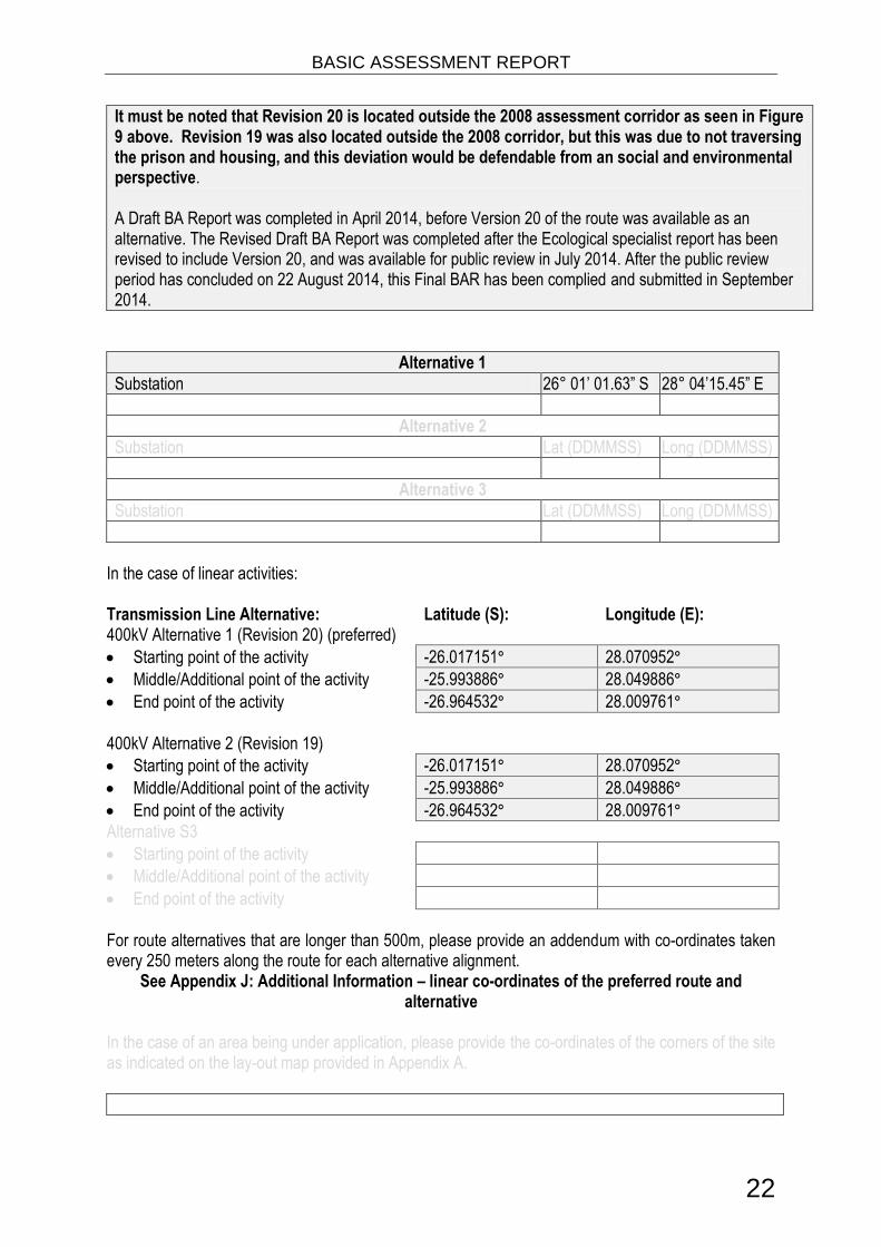
It must be noted that Revision 20 is located outside the 2008 assessment corridor as seen in Figure 9 above. Revision 19 was also located outside the 2008 corridor, but this was due to not traversing the prison and housing, and this deviation would be defendable from an social and environmental perspective. A Draft BA Report was completed in April 2014, before Version 20 of the route was available as an alternative. The Revised Draft BA Report was completed after the Ecological specialist report has been revised to include Version 20, and was available for public review in July 2014. After the public review period has concluded on 22 August 2014, this Final BAR has been complied and submitted in September 2014.
Alternative 1
Substation 26° 01’ 01.63” S 28° 04’15.45” E
Alternative 2
Substation Lat (DDMMSS) Long (DDMMSS)
Alternative 3
Substation Lat (DDMMSS) Long (DDMMSS)
In the case of linear activities: Transmission Line Alternative: Latitude (S): Longitude (E): 400kV Alternative 1 (Revision 20) (preferred)
Starting point of the activity -26.017151° 28.070952°
Middle/Additional point of the activity -25.993886° 28.049886°
End point of the activity -26.964532° 28.009761°
400kV Alternative 2 (Revision 19)
Starting point of the activity -26.017151° 28.070952°
Middle/Additional point of the activity -25.993886° 28.049886°
End point of the activity -26.964532° 28.009761°
Alternative S3
Starting point of the activity
Middle/Additional point of the activity
End point of the activity
For route alternatives that are longer than 500m, please provide an addendum with co-ordinates taken every 250 meters along the route for each alternative alignment.
See Appendix J: Additional Information – linear co-ordinates of the preferred route and alternative
In the case of an area being under application, please provide the co-ordinates of the corners of the site as indicated on the lay-out map provided in Appendix A.

BASIC ASSESSMENT REPORT
23
b) Lay-out alternatives
Alternative 1 (preferred alternative)
Description Lat (DDMMSS) Long (DDMMSS)
Alternative 2
Description Lat (DDMMSS) Long (DDMMSS)
Alternative 3
Description Lat (DDMMSS) Long (DDMMSS)
c) Technology alternatives
Alternative 1 (preferred alternative)
Alternative 2
d) Other alternatives (e.g. scheduling, demand, input, scale and design alternatives)
Alternative 1 (preferred alternative)
Alternative 2
Alternative 3
e) No-go alternative
The No-go option implies that the Project does not proceed, and Eskom does not go ahead with the construction of the 400kV power line. The implications of No-go alternative include:
The is no change to current landscape;
Electricity distribution to the area will not improve, leaving certain areas without reliable supply;
Disadvantaged communities will have few alternatives to continuing use of fires for cooking food and heating their houses. (Infrastructure for solar energy is not affordable to them)
The terms of National initiatives such as the Strategic Development Plan and Frameworks will not be met.
Paragraphs 3 – 13 below should be completed for each alternative.
*Note: information on both alternatives are combined in paragraphs 3-13

BASIC ASSESSMENT REPORT
24
3. PHYSICAL SIZE OF THE ACTIVITY a) Indicate the physical size of the preferred activity/technology as well as alternative
activities/technologies (footprints): Substation Alternative: Size of the activity:
Alternative A12 (preferred activity alternative) 10 000m2
Alternative A2 (Size not feasible) 160 000m2
Alternative A3 (if any) m2
or, for linear activities: Transmission Line Alternative: Length of the activity:
Alternative 1 (Revision 20, Preferred) Approx 13 km
Alternative 2 (Revision 19) Approx 13 km
Alternative A3
b) Indicate the size of the alternative sites or servitudes (within which the above footprints
will occur): Alternative: Size of the site/servitude:
Alternative 1 (Revision 20, Preferred) Distance x 110m servitude
1 430 000 m2
Alternative 2 (Revision 19) Distance x 110m servitude
1 430 000 m2
Alternative A3 Distance x m servitude m2
4. SITE ACCESS
Does ready access to the site exist? YES √ NO√
If NO, what is the distance over which a new access road will be built 5km maintenance track
Describe the type of access road planned:
The proposed transmission will be in close proximity to existing road, maintenance tracks and existing distribution lines. However, a maintenance track will however be required for the line. A maintenance track of approximately 5 kilometres will be required on Farm Rietfontein 2. The maintenance track could trigger listing Notice 3, as large section of the transmission line are located in areas identified as Critical Biodiversity Areas and Ecological Support Areas in the Gauteng C-Plan 3.3. The maintenance track will be a 8metre wide strip, which will also be used for stringing purposes. No scalping, grading or bulldozing of the maintenance track will be allowed. .
Include the position of the access road on the site plan and required map, as well as an indication of the road in relation to the site.
2 “Alternative A..” refer to activity, process, technology or other alternatives.

BASIC ASSESSMENT REPORT
25
5. LOCALITY MAP
An A3 locality map must be attached to the back of this document, as Appendix A. The scale of the locality map must be relevant to the size of the development (at least 1:50 000. For linear activities of more than 25 kilometres, a smaller scale e.g. 1:250 000 can be used. The scale must be indicated on the map.). The map must indicate the following:
an accurate indication of the project site position as well as the positions of the alternative sites, if any;
indication of all the alternatives identified;
closest town(s;)
road access from all major roads in the area;
road names or numbers of all major roads as well as the roads that provide access to the site(s);
all roads within a 1km radius of the site or alternative sites; and
a north arrow;
a legend; and
locality GPS co-ordinates (Indicate the position of the activity using the latitude and longitude of the centre point of the site for each alternative site. The co-ordinates should be in degrees and decimal minutes. The minutes should have at least three decimals to ensure adequate accuracy. The projection that must be used in all cases is the WGS84 spheroid in a national or local projection).
6. LAYOUT/ROUTE PLAN A detailed site or route plan(s) must be prepared for each alternative site or alternative activity. It must be attached as Appendix A to this document. The site or route plans must indicate the following:
the property boundaries and numbers of all the properties within 50 metres of the site;
the current land use as well as the land use zoning of the site;
the current land use as well as the land use zoning each of the properties adjoining the site or sites;
the exact position of each listed activity applied for (including alternatives);
servitude(s) indicating the purpose of the servitude;
a legend; and
a north arrow. 7. SENSITIVITY MAP The layout/route plan as indicated above must be overlain with a sensitivity map that indicates all the sensitive areas associated with the site, including, but not limited to:
watercourses;
the 1:100 year flood line (where available or where it is required by DWA);
ridges;
cultural and historical features;
areas with indigenous vegetation (even if it is degraded or infested with alien species); and
critical biodiversity areas.

BASIC ASSESSMENT REPORT
26
The sensitivity map must also cover areas within 100m of the site and must be attached in Appendix A. 8. SITE PHOTOGRAPHS Colour photographs from the centre of the site must be taken in at least the eight major compass directions with a description of each photograph. Photographs must be attached under Appendix B to this report. It must be supplemented with additional photographs of relevant features on the site, if applicable. 9. FACILITY ILLUSTRATION A detailed illustration of the activity must be provided at a scale of at least 1:200 as Appendix C for activities that include structures. The illustrations must be to scale and must represent a realistic image of the planned activity. The illustration must give a representative view of the activity. 10. ACTIVITY MOTIVATION Motivate and explain the need and desirability of the activity (including demand for the activity):
1. Is the activity permitted in terms of the property’s existing land use rights?
YES√ NO Please explain
The area is currently used for agricultural small holdings and institutional agriculture at Leeukop Correctional Facility. Once constructed the area servitude will still be used for agriculture.
2. Will the activity be in line with the following?
(a) Provincial Spatial Development Framework (PSDF) YES √ NO Please explain
The infrastructure network of the Province is a strategic, socio-economic and bulk infrastructure investment and includes: transport and logistics (including roads, rail and air), Information and Communication and e Technologies, schools, hospitals, clinics, libraries, universities (if applicable), electricity services (energy), water reticulation services, sewage and sanitation services, waste management services, and so forth. Thus the provision of provision of electrical infrastructure is in line with SDF.
(b) Urban edge / Edge of Built environment for the area YES NO√ Please explain
The proposed transmission lines fall outside and inside the urban edge. However, electricity transmission infrastructure is required for areas outside the urban edge. The project will strengthen the electricity distribution network in the area, which is both inside and outside the urban edge.
(c) Integrated Development Plan (IDP) and Spatial Development Framework (SDF) of the Local Municipality (e.g. would the approval of this application compromise the integrity of the existing approved and credible municipal IDP and SDF?).
YES NO√ Please explain
The SDF will not be compromised by the development. .

BASIC ASSESSMENT REPORT
27
(d) Approved Structure Plan of the Municipality YES√ NO Please explain
The proposed project entails electricity infrastructure, which is compatible with Provincial and Local Municipality objectives.
(e) An Environmental Management Framework (EMF) adopted by the Department (e.g. Would the approval of this application compromise the integrity of the existing environmental management priorities for the area and if so, can it be justified in terms of sustainability considerations?)
YES NO√ Please explain
No promulgated EMF for study area. AS per the NEMA EMF Regulations a legal process of adoption and consideration of EMF’s is required. The September 2009 Regional Environmental Management Framework for South Western Tshwane And North Western Johannesburg was taken into consideration for this project. The project will not compromise the integrity of the environment
(f) Any other Plans (e.g. Guide Plan) YES NO√ Please explain
The proposed project entails electricity infrastructure, which is compatible with Provincial and Local Municipality objectives
3. Is the land use (associated with the activity being applied for) considered within the timeframe intended by the existing approved SDF agreed to by the relevant environmental authority (i.e. is the proposed development in line with the projects and programmes identified as priorities within the credible IDP)?
YES√ NO Please explain
The proposed development is in line with the National Development Plan, which related to the provision of infrastructure such as electricity supply.
4. Does the community/area need the activity and the associated land use concerned (is it a societal priority)? (This refers to the strategic as well as local level (e.g. development is a national priority, but within a specific local context it could be inappropriate.)
YES√ NO Please explain
The area requires additional electricity capacity to provide a reliable electricity supply to existing customers and additional capacity for economic growth and creation of jobs.
5. Are the necessary services with adequate capacity currently available (at the time of application), or must additional capacity be created to cater for the development? (Confirmation by the relevant Municipality in this regard must be attached to the final Basic Assessment Report as Appendix I.)
YES√ NO Please explain
The proposed 400kV transmission line will not require any. The substation will require limited services such as water and sanitation from relevant Municipalities. It will provide additional electricity capacity to the Kyalami – Midrand area.

BASIC ASSESSMENT REPORT
28
6. Is this development provided for in the infrastructure planning of the municipality, and if not what will the implication be on the infrastructure planning of the municipality (priority and placement of services and opportunity costs)? (Comment by the relevant Municipality in this regard must be attached to the final Basic Assessment Report as Appendix I.)
YES NO√ Please explain
The proposed project is the construction of a 400kV transmission line. It will not require any capacity for services such as water and sanitation from relevant Municipalities. It will however provide additional electricity capacity to Kyalami – Midrand.
7. Is this project part of a national programme to address an issue of national concern or importance?
YES √ NO Please explain
The proposed development is in line with the National Development Plan, which related to the provision of infrastructure such as electricity supply.
8. Do location factors favour this land use (associated with the activity applied for) at this place? (This relates to the contextualisation of the proposed land use on this site within its broader context.)
YES√ NO Please explain
The transmission line is in close proximity to existing power lines in the area. The servitude underneath the proposed power line will still be used for farming and small holding agriculture activities.
9. Is the development the best practicable environmental option for this land/site?
YES NO√ Please explain
The land use of a few non commercially viable small holdings might be affected, but financial compensation has been paid. The proposed transmission lines will be located in an area used primarily for agriculture and agricultural smallholdings. Once the construction phase of the proposed transmission line is completed, the servitude area will continue to be used for agriculture
10. Will the benefits of the proposed land use/development outweigh the negative impacts of it?
YES√ NO Please explain
The proposed 400kV transmission line will be beneficial to the local economy.
11. Will the proposed land use/development set a precedent for similar activities in the area (local municipality)?
YES NO√ Please explain
The preferred alternative is adjacent to the existing power lines. The servitude underneath the proposed power line will still be used for commercial stock farming activities.
12. Will any person’s rights be negatively affected by the proposed activity/ies?
YES NO√ Please explain
The proposed transmission line will not negatively affect any persons rights. Servitude agreements have been signed with most land owners post Environmental Authorisation in 2010.
13. Will the proposed activity/ies compromise the “urban edge” as defined by the local municipality?
YES NO√ Please explain
The project is the proposed construction of an electricity transmission line within and outside the urban edge. Areas outside of the urban edge and rural areas do require electricity.

BASIC ASSESSMENT REPORT
29
14. Will the proposed activity/ies contribute to any of the 17 Strategic Integrated Projects (SIPS)?
YES√ NO Please explain
The project will conform to the objectives of the following SIPS:
SIP 6: Integrated Municipal Infrastructure Project
Develop a national capacity to assist the 23 least resourced districts (17 million people) to address all the maintenance backlogs and upgrades required in water, electricity and sanitation bulk infrastructure.
SIP 10: Electricity Transmission and Distribution for all
Expand the transmission and distribution network to address historical imbalances, provide access to electricity for all and support economic development. Align the 10-year transmission plan, the services backlog, the national broadband roll-out and the freight rail line development to leverage off regulatory approvals, supply chain and project development capacity.
15. What will the benefits be to society in general and to the local communities?
Please explain
The provision of a reliable electricity network and provision of capacity for new users.
16. Any other need and desirability considerations related to the proposed activity?
Please explain
The proposed project will ensure that economic growth continues in the Region and existing customer
have a more reliable supply of electricity.
17. How does the project fit into the National Development Plan for 2030? Please explain
The following NDP sections area relevant: ELEMENTS OF A DECENT STANDARD OF LIVING = Electricity WOMEN AND THE PLAN = Access to safe drinking water, electricity and quality early childhood education, for example, could free women from doing unpaid work and help them seek jobs. Due to a reduction in capital spending from effect, South Africa has missed a generation of capital investment in roads, rail, ports, electricity, water, sanitation, public transport and housing. To grow faster and in a more inclusive manner, the country needs a higher level of capital spending. Chapter 4: ECONOMIC INFRASTRUCTURE Objectives: The proportion of people with access to the electricity grid should rise to at least 90 percent by 2030, with non-grid options available for the rest. Actions: 21. Revise national electrification plan and ensure 90 percent grid access by 2030 (with balance met through off-grid technologies).
18. Please describe how the general objectives of Integrated Environmental Management as set out in section 23 of NEMA have been taken into account.
In order to comply with NEMA Section 23 (National Environmental Management Act) principles of Integrated Environmental Management a Basic Assessment Report was completed. A public participation process (PPP) was undertaken for the proposed transmission line to investigate and assess any potential environmental impacts associated with the development prior to construction. As part of the BA process several specialist studies were conducted to evaluate potential impact that the proposed development could have on the study area.

BASIC ASSESSMENT REPORT
30
19. Please describe how the principles of environmental management as set out in section 2 of NEMA have been taken into account.
NEMA Section 2 (National Environmental Management Act) principles of environmental management require that environmental management must place people and their needs at the forefront of development and that development must be socially, environmentally and economically sustainable. These principles have been taken into account during the PPP in order to ensure that all Interested and Affected Parties (I&APs) are given the opportunity to be involved in the process. I&AP’s comments are thus taken into consideration by the DEA when reviewing the application. Specialist studies were conducted.
11. APPLICABLE LEGISLATION, POLICIES AND/OR GUIDELINES List all legislation, policies and/or guidelines of any sphere of government that are applicable to the application as contemplated in the EIA regulations, if applicable:
Title of legislation, policy or guideline
Applicability to the project Administering authority
Date
National Environmental Management Act, No. 107 of 1998 (NEMA), as amended & NEMA EIA Regulations, 2010: GN544, published in Government Gazette 33306 on 18 June 2010
a Basic Assessment Report (BAR) is required for this project.
Department of Environmental Affairs (DEA)
1998
National Water Act, No. 36 of 1998
The proposed transmission lines may trigger a section 21(C and/or i) water use.
Department of Water Affairs (DWA)
1998
National Heritage Resources Act (Act No 25 of 1999)
Resources could be identified during construction phase
South African Heritage Resources Agency
1999
12. WASTE, EFFLUENT, EMISSION AND NOISE MANAGEMENT a) Solid waste management
Will the activity produce solid construction waste during the construction/initiation phase?
YES
√ NO
If YES, what estimated quantity will be produced per month? +/- 6 m3
Small quantities of solid waste will be generated during the construction phase of the project. This waste will be disposed at a licensed waste facility by the contractor..
How will the construction solid waste be disposed of (describe)?
Solid waste will be generated during the construction phase of the project will be disposed at a licensed waste facility by the contractor.
Where will the construction solid waste be disposed of (describe)?

BASIC ASSESSMENT REPORT
31
This waste will be disposed at a licensed waste facility by the contractor.. The Municipalities in the study area have existing waste facilities. As a mitigatory measure the contractor will be responsible for ensuring that all waste is disposal at a licensed Waste facility.Licensed facilities in the study area include:
Permit Number
Waste Disposal Site
Classification Date Issued
Permit Holder
PO Box
Town Code
12/9/11/L53/3 Ennerdale Landfill Site
G:M:B- 12/11/2009 PIKITUP Johannesburg (PTY)LTD
Private Bag X74
Braamfontein 2017
B33/2/2010/5/P22 22 Robinson Deep G:L:B- 14/08/1992 City Council of Johannesburg
P. O. Box 4323
Johannesburg 2000
B33/2/121/173/P1 1 Linbropark G:L:B- 25/04/1991 Johannesburg City Council
P. O. Box 4323
Johannesburg 2000
B33/2/1300S/P15 15 Goudkoppies G:L:B+ 12/08/1992 City Council of Johannesburg
P. O. Box 4323
Johannesburg 2000
12/9/11/L500/3 Pikitup general and hazardous waste storage, shreding,grinding orbailing of general waste
H:H 27/01/2011 Pikitup Haylon Hill
Private Bag x 74
Johannesburg 2017
Will the activity produce solid waste during its operational phase? YES NO √
If YES, what estimated quantity will be produced per month? m3
How will the solid waste be disposed of (describe)?
If the solid waste will be disposed of into a municipal waste stream, indicate which registered landfill site will be used.
Where will the solid waste be disposed of if it does not feed into a municipal waste stream (describe)?
If the solid waste (construction or operational phases) will not be disposed of in a registered landfill site or be taken up in a municipal waste stream, then the applicant should consult with the competent authority to determine whether it is necessary to change to an application for scoping and EIA.
Can any part of the solid waste be classified as hazardous in terms of the NEM:WA? YES NO √
If YES, inform the competent authority and request a change to an application for scoping and EIA. An application for a waste permit in terms of the NEM:WA must also be submitted with this application.
Is the activity that is being applied for a solid waste handling or treatment facility? YES NO√
If YES, then the applicant should consult with the competent authority to determine whether it is necessary to change to an application for scoping and EIA. An application for a waste permit in terms of the NEM:WA must also be submitted with this application. b) Liquid effluent
Will the activity produce effluent, other than normal sewage, that will be disposed of in a municipal sewage system? YES√ NO

BASIC ASSESSMENT REPORT
32
If YES, what estimated quantity will be produced per month? 1 m3
Will the activity produce any effluent that will be treated and/or disposed of on site? YES NO√
If YES, the applicant should consult with the competent authority to determine whether it is necessary to change to an application for scoping and EIA.
Will the activity produce effluent that will be treated and/or disposed of at another facility?
YES NO√
If YES, provide the particulars of the facility:
Facility name:
Contact person:
Postal address:
Postal code:
Telephone: Cell:
E-mail: Fax:
Describe the measures that will be taken to ensure the optimal reuse or recycling of waste water, if any:
The substation will have for a toilet which could be used occasionally during the operational phase. Dual flush toilet will be utilised
c) Emissions into the atmosphere
Will the activity release emissions into the atmosphere other that exhaust emissions and dust associated with construction phase activities?
YES NO √
If YES, is it controlled by any legislation of any sphere of government? YES NO√
If YES, the applicant must consult with the competent authority to determine whether it is necessary to change to an application for scoping and EIA. If NO, describe the emissions in terms of type and concentration:
During the construction phase, dust and vehicular emissions will be released as a result of vehicle movements. However these emissions will have a short term impact on the immediate surrounding area and thus no authorisation will be required for such emissions. Appropriate dust suppression measures must be implemented (e.g. removal of vegetation in a phased manner and using recycled water for spraying dust to reduce the impacts). Dust generated during construction will not exceed limits proposed Notice 309 of 2011 National Environmental Management: Air Quality Act, 2004. (Act 39 0f 2004), Draft National Dust Control Regulations
d) Waste permit
Will any aspect of the activity produce waste that will require a waste permit in terms of the NEM:WA?
YES NO√
If YES, please submit evidence that an application for a waste permit has been submitted to the competent authority

BASIC ASSESSMENT REPORT
33
e) Generation of noise
Will the activity generate noise? YES NO √
If YES, is it controlled by any legislation of any sphere of government? YES NO√
If YES, the applicant should consult with the competent authority to determine whether it is necessary to change to an application for scoping and EIA. If NO, describe the noise in terms of type and level:
A limited amount of noise would be generated during the construction phase by construction vehicles and construction activities. It will however be short term, localised and will last during the construction phase. In order to minimise the impacts of noise during the construction phase, construction activities should be restricted to between 07H00 and 17H00 Monday to Friday. This is required in order to avoid noise and lighting disturbances outside of normal working hours. All construction equipment must be maintained and kept in good working order to minimise associated noise impacts. If required, adequate noise suppression measures (i.e. screens, etc) must be erected around the point source of construction and/or operational noise pollution to reduce noise to an acceptable level.
13. WATER USE Please indicate the source(s) of water that will be used for the activity by ticking the appropriate box(es):
Municipal√ Water board Groundwater River, stream, dam or lake
Other The activity will not use water
If water is to be extracted from groundwater, river, stream, dam, lake or any other natural feature, please indicate the volume that will be extracted per month:
Zero litres
Does the activity require a water use authorisation (general authorisation or water use license) from the Department of Water Affairs?
YES NO√
If YES, please provide proof that the application has been submitted to the Department of Water Affairs.
14. ENERGY EFFICIENCY Describe the design measures, if any, that have been taken to ensure that the activity is energy efficient:
The project is the construction of a transmission line and does not use energy. Eskom however has introduced and champions the 49m campaign which aims to reduce National energy usage by 10%, which would be as effective as the construction of a new power station, without the potential carbon emission or cost. .
Describe how alternative energy sources have been taken into account or been built into the design of the activity, if any:
The project is the construction of a transmission line and does not use energy. Eskom however has introduced and champions the 49m campaign which aims to reduce National energy usage by 10%, which would be as effective as the construction of a new power station, without the potential carbon emission or cost. .

BASIC ASSESSMENT REPORT
34
SECTION B: SITE/AREA/PROPERTY DESCRIPTION Important notes: 1. For linear activities (pipelines, etc) as well as activities that cover very large sites, it may be
necessary to complete this section for each part of the site that has a significantly different environment. In such cases please complete copies of Section B and indicate the area, which is covered by each copy No. on the Site Plan.
Section B Copy No. (e.g. A):
2. Paragraphs 1 - 6 below must be completed for each alternative.
3. Has a specialist been consulted to assist with the completion of this section? YES√ NO
If YES, please complete the form entitled “Details of specialist and declaration of interest” for each specialist thus appointed and attach it in Appendix I. All specialist reports must be contained in Appendix D. Property description/physical address:
Province Gauteng
District Municipality
Johannesburg Metropolitan Municipality
Local Municipality Johannesburg Metropolitan Municipality
Ward Number(s) 93, 94 and 96
Farm name and number
See Appendix E 5
Portion number See Appendix E 5
SG Code See Appendix E 5
Where a large number of properties are involved (e.g. linear activities), please attach a full list to this application including the same information as indicated above. See Appendix E 5
Current land-use zoning as per local municipality IDP/records:
Agriculture, Agriculture holdings and State land.
In instances where there is more than one current land-use zoning, please attach a list of current land use zonings that also indicate which portions each use pertains to, to this application.
Is a change of land-use or a consent use application required? YES NO√

BASIC ASSESSMENT REPORT
35
1. GRADIENT OF THE SITE Indicate the general gradient of the site. Alternative 1: Revision 20:
Flat 1:50 – 1:20 1:20 – 1:15
√
1:15 – 1:10 1:10 – 1:7,5 1:7,5 – 1:5
√
Steeper than 1:5
Alternative 2: Revision 19
Flat 1:50 – 1:20 1:20 – 1:15
√
1:15 – 1:10 1:10 – 1:7,5 1:7,5 – 1:5
√
Steeper than 1:5
Alternative 3:
Flat 1:50 – 1:20 1:20 – 1:15 1:15 – 1:10 1:10 – 1:7,5 1:7,5 – 1:5 Steeper than 1:5
2. LOCATION IN LANDSCAPE Indicate the landform(s) that best describes the site:
2.1 Ridgeline 2.4 Closed valley 2.7 Undulating plain / low hills
2.2 Plateau √ 2.5 Open valley √ 2.8 Dune
2.3 Side slope of hill/mountain √ 2.6 Plain √ 2.9 Seafront

BASIC ASSESSMENT REPORT
36
3. GROUNDWATER, SOIL AND GEOLOGICAL STABILITY OF THE SITE Is the site(s) located on any of the following? 400kV Route Alternatives Alternative 1: Alternative 2 Alternative S3:
Shallow water table (less than 1.5m deep) YES NO√ YES NO√ YES NO
Dolomite, sinkhole or doline areas YES NO√ YES NO√ YES NO
Seasonally wet soils (often close to water bodies)
YES
√ NO
YES
√ NO
YES NO
Unstable rocky slopes or steep slopes with loose soil
YES NO√
YES NO√
YES NO
Dispersive soils (soils that dissolve in water) YES NO√ YES NO√ YES NO
Soils with high clay content (clay fraction more than 40%)
YES NO√
YES NO√
YES NO
Any other unstable soil or geological feature YES
√ NO
YES
√ NO
YES NO
An area sensitive to erosion YES
√ NO
YES
√ NO
YES NO
If you are unsure about any of the above or if you are concerned that any of the above aspects may be an issue of concern in the application, an appropriate specialist should be appointed to assist in the completion of this section. Information in respect of the above will often be available as part of the project information or at the planning sections of local authorities. Where it exists, the 1:50 000 scale Regional Geotechnical Maps prepared by the Council for Geo Science may also be consulted.
Geology and Soil: M. J. van der Walt Engineering Geologist CC (2014) describes that according to the available geological map sheet 2528 Pretoria at a scale of 1:250 000 the power line route is underlain by granite and gneiss of Swazian geological age, i.e. rocks of the Basement Complex. Diabase in the form of dykes has intruded into the host rock. The climatic regime of the present and of the relatively recent plays a fundamental role in the development of the soil profile at any particular point below the earth’s surface. As the site falls within the more humid part of South Africa where Weinerts climatic N-value is less than 5, residual soils are generally deep, transported soils shallow, and pedocretes where present, are likely to be in the form of ferricrete. The various geological formations that would be encountered are described below:
Fine-grained silty and sandy colluvium (transported soil), possibly with a pebble marker horizon at the bottom, both classed as Recent Deposits;
Fine-grained (silt & clay) as well as coarse-grained (sand & gravel) alluvium, Recent Deposit;
Pedocretes, generally in the form of ferruginous concretions or a well-developed ferricrete layer at the base of the transported soils;
Diabase intrusions mainly in the form of dykes; and
Granite and gneiss belonging to the Basement Complex.

BASIC ASSESSMENT REPORT
37
The residual soil generally contains a high percentage of montmorillonite and is therefore potentially expansive with soil moisture fluctuations. Owing to the fact that diabase dykes and sills are often more deeply decomposed than the country rock into which they are intrusive, these features commonly present problems in tunnelling or in open excavations. Differential settlement may occur if foundations straddle the diabase/host rock boundary. The hazards associated with ”mudrushes” in completely decomposed dykes, and ravelling from “running dykes” where the material may be less decomposed but highly jointed, are well known to tunnelling engineers. Stability of open excavations through residual diabase is always problematic and the problem becomes critical particularly in situations where the residual diabase is squeezed out under the load of overlying strata. When diabase occurs in areas with a relatively shallow water table the practical problem with residual diabase is not one of heaving but of settlement due to drying out of the soil during prolonged periods of drought.
4. GROUNDCOVER Indicate the types of groundcover present on the site. The location of all identified rare or endangered species or other elements should be accurately indicated on the site plan(s).
Natural veld - good condition E
√
Natural veld with scattered aliens E
√
Natural veld with heavy alien
infestation √
Veld dominated by alien speciesE Gardens √
Sport field Cultivated land√ Paved surface Building or other structure Bare soil√
If any of the boxes marked with an “E “is ticked, please consult an appropriate specialist to assist in the completion of this section if the environmental assessment practitioner doesn’t have the necessary expertise.
Agricultural holdings or small holdings were present along the routes of the proposed study area. The majority of the agricultural holdings are utilized as homesteads, some with stables and riding facilities. Some agricultural holdings are utilized for light industry. Each agricultural holding is separated from the neighbouring holding by fences or walls and are connected via a road network. Other parts of the site are relatively transformed due to human impacts such as roads, erosion, crop production, grazing especially by horses, golf driving ranges, etc. The study area falls within the Grassland Biome. The largest part of the power line route falls within the endangered Egoli Granite Grassland (Gm10). Prof. PJ du Preez identified the vegetation on ridge/koppies as Gold Reef Mountain Bushveld (Svcb9). According to the Geological specialist report, the climatic regime of the present and of the relatively recent plays a fundamental role in the development of the soil profile at any particular point below the earth’s surface. As the site falls within the more humid part of South Africa where Weinerts climatic N-value is less than 5, residual soils are generally deep, transported soils shallow, and pedocretes where present, are likely to be in the form of ferricrete. Stability of open excavations through residual diabase is always problematic and the problem becomes critical particularly in situations where the residual diabase is squeezed out under the load of overlying strata. When diabase occurs in areas with a relatively shallow water table the practical problem with residual diabase is not one of heaving but of settlement due to drying out of the soil during prolonged periods of drought.

BASIC ASSESSMENT REPORT
38
Figure 10. Vegetation
5. SURFACE WATER Indicate the surface water present on and or adjacent to the site and alternative sites?
Perennial River YES√ NO UNSURE
Non-Perennial River YES NO√ UNSURE
Permanent Wetland YES√ NO UNSURE
Seasonal Wetland YES√ NO UNSURE
Artificial Wetland YES√ NO UNSURE
Estuarine / Lagoonal wetland YES NO √ UNSURE
If any of the boxes marked YES or UNSURE is ticked, please provide a description of the relevant watercourse.
The proposed route traverses the Jukskei River. The National Freshwater Ecosystem Priority Area data (See Figure 11) indicates that many wetlands are to be found in the area. In addition the entire area is located on Egoli Granite Grassland, which usually results in valley bottom wetlands without channel, due to water not draining easily. These systems tend to be found in the upper catchment areas, or at tributary junctions where the sediment from the tributary smothers the main drainage line.

BASIC ASSESSMENT REPORT
39
Figure 11. Surface Water
6. LAND USE CHARACTER OF SURROUNDING AREA Indicate land uses and/or prominent features that currently occur within a 500m radius of the site and give description of how this influences the application or may be impacted upon by the application:
Natural area √ Dam or reservoir √ Polo fields
Low density residential√ Hospital/medical centre Filling station H
Medium density residential √ School Landfill or waste treatment site
High density residential Tertiary education facility Plantation
Informal residential A Church √ Agriculture √
Retail commercial & warehousing Old age home River, stream or wetland √
Light industrial Sewage treatment plant A Nature conservation area
Medium industrial AN Train station or shunting yard N Mountain, koppie or ridge √
Heavy industrialAN Railway line N Museum
Power station Major road (4 lanes or more) N Historical building
Office/consulting room √ Airport N Protected Area
Military or police base/station/compound
Harbour Graveyard
Spoil heap or slimes damA Sport facilities √ Archaeological site
Quarry, sand or borrow pit √ Golf course √ Other land uses (describe)

BASIC ASSESSMENT REPORT
40
If any of the boxes marked with an “N “are ticked, how will this impact / be impacted upon by the proposed activity?
If any of the boxes marked with an "An" are ticked, how will this impact / be impacted upon by the proposed activity? Specify and explain:
If any of the boxes marked with an "H" are ticked, how will this impact / be impacted upon by the proposed activity? Specify and explain:
Does the proposed site (including any alternative sites) fall within any of the following:
Critical Biodiversity Area (as per provincial conservation plan) YES√ NO
Core area of a protected area? YES NO √
Buffer area of a protected area? YES NO √
Planned expansion area of an existing protected area? YES NO √
Existing offset area associated with a previous Environmental Authorisation? YES NO √
Buffer area of the SKA? YES NO √
The proposed 400kV line is located within sites identifies and Important and irreplaceable as per the Gauteng C-Plan 3.3. See map in Appendix A
If the answer to any of these questions was YES, a map indicating the affected area must be included in Appendix A. 7. CULTURAL/HISTORICAL FEATURES
Are there any signs of culturally or historically significant elements, as defined in section 2 of the National Heritage Resources Act, 1999, (Act No. 25 of 1999), including Archaeological or paleontological sites, on or close (within 20m) to the site? If YES, explain:
YES NO √
Uncertain
If uncertain, conduct a specialist investigation by a recognised specialist in the field (archaeology or palaeontology) to establish whether there is such a feature(s) present on or close to the site. Briefly explain the findings of the specialist:
The 2008/9 EIA determined that no heritage sites of significance were identified within the proposed power line corridors or at the proposed substation sites and therefore the impacts on heritage sites associated with the proposed project are expected to be of low significance. The South African Heritage Resources Agency (SAHRA), have confirmed this and have provided Section 38 statutory comment.
Will any building or structure older than 60 years be affected in any way? YES NO √ Is it necessary to apply for a permit in terms of the National Heritage Resources Act, 1999 (Act 25 of 1999)?
YES NO √

BASIC ASSESSMENT REPORT
41
If YES, please provide proof that this permit application has been submitted to SAHRA or the relevant provincial authority. 8. SOCIO-ECONOMIC CHARACTER a) Local Municipality Please provide details on the socio-economic character of the local municipality in which the proposed site(s) are situated. Level of unemployment:
The 2011 Census data indicates the following:
JOHANNESBURG WARDS UNEMPLOYMENT
RATE
YOUTH UNEMPLOYMENT
RATE
Ward 93 29.7 % 37.2 %
Ward 94 17.7 % 22.4 %
Ward 96 19.2 % 22.7 %
In addition the Eastern Sub-Region of Region A, the general unemployment rate is very low at just 6%. This figure compares favourably with the national unemployment rate of 24%. A large section of those that are employed are employed within the financial sector, followed by the retail sector. The income levels match the high employment rate as a large sector of the population within the Eastern Sub-Region falls within high income categories. The nearby Diepsloot, area, however, is said to have an unemployment rate of over 50%, and 70% of that specific population is living below the poverty line. It was further stated that 70% of those living in the Midrand area earned less than R2 500 per month, while 34% had no income.
Economic profile of local municipality: Infrastructure Due to the development explosion the roads in the study area are under tremendous pressure to handle the increase in traffic, especially in the Kyalami, Midrand and Sunninghill areas. Furthermore, it should be noted that the public transport network within the Eastern Sub-Region is not up to standard and would need to be addressed. As part of the Steyncity project some roads are being upgraded in the western section of the study area which is focused on the William Nicol Drive (R511) and Erling Street interchange upgrades. Basic Services The majority of residents in the study area and the Eastern Sub-Region have access to piped water The Diepsloot area, however, is in serious need of proper water and sanitation services. Water contamination created various problems in 2012. The complexity of the water and sanitation problem is vast and remains to require attention for upgrading. It should however, further be noted that the Steyn City project will make a significant contribution towards regional bulk services upgrading, as well as municipal sewers and bulk water supply. This bulk upgrading will help to unlock services for many other developments in the sub-region including Diepsloot East, Tanganani, Riversands and the City of Joburg (www.diepsloot.com).

BASIC ASSESSMENT REPORT
42
Tourism Sectors The conservation of the natural environment and equestrian feel of the area is thus of the utmost importance to the residents living in the Kyalami Agricultural Holdings, the Glenferness Agricultural Holdings, as well as the Treesbank and Kleve Agricultural Holdings. Some residents are also of the opinion that the equestrian industry would be negatively affected by the proposed power lines due to the relocation of residents, as well as the visual impact on the tourism industry associated with the equestrian industry (e.g. impact on the sense of place of visitors to the equestrian shows and competitions hosted in the area). It should, however, be noted that the existing power lines traversing the area could already impact on the sense of place with regards to the equestrian industry.
Level of education:
The education profiles within the District and Local Municipalities within the study area are as follows (2011 statistics):
WARD NO SCHOOLING
Ward 93 1.14%
Ward 94 1.57%
Ward 96 3.48%
The education levels of the population within the Eastern-Sub Region are higher than the national average which is an indication of the income levels in the area. Sixty percent of the residents have completed secondary school and 14% have achieved a higher education level. Merely 18% have only completed primary school (Maluleke, Luthuli and Associates, 2008).
b) Socio-economic value of the activity
What is the expected capital value of the activity on completion? R300,000,000.00
What is the expected yearly income that will be generated by or as a result of the activity?
Eskom fees
Will the activity contribute to service infrastructure? YES√ NO
Is the activity a public amenity? YES√ NO
How many new employment opportunities will be created in the development and construction phase of the activity/ies?
Unknown
What is the expected value of the employment opportunities during the development and construction phase?
R100,000,000.00
What percentage of this will accrue to previously disadvantaged individuals? +/- 70%
How many permanent new employment opportunities will be created during the operational phase of the activity?
None
What is the expected current value of the employment opportunities during the first 10 years?
None
What percentage of this will accrue to previously disadvantaged individuals? +/- 80%

BASIC ASSESSMENT REPORT
43
Socio-economic value Brian Dames (Business Day April 07 2014) discussed that the build programme (From 2005) has had significant socioeconomic benefits — it is employing more than 35,000 people, of whom about 16,000 are from the districts around the projects. More than 6,000 people have benefited from skills training, and an enormous R86bn, or 63% of Eskom’s procurement spend, has been spent on South African goods and services. In the 2013 financial year, R103bn of Eskom’s total procurement went to broad-based black economic empowerment entities, of which R26.5bn went to black-owned companies, R5.7bn to black women-owned companies and R1.2bn to black youth-owned companies.
9. BIODIVERSITY Please note: The Department may request specialist input/studies depending on the nature of the biodiversity occurring on the site and potential impact(s) of the proposed activity/ies. To assist with the identification of the biodiversity occurring on site and the ecosystem status consult http://bgis.sanbi.org or [email protected]. Information is also available on compact disc (cd) from the Biodiversity-GIS Unit, Ph (021) 799 8698. This information may be updated from time to time and it is the applicant/ EAP’s responsibility to ensure that the latest version is used. A map of the relevant biodiversity information (including an indication of the habitat conditions as per (b) below) and must be provided as an overlay map to the property/site plan as Appendix D to this report. a) Indicate the applicable biodiversity planning categories of all areas on site and indicate
the reason(s) provided in the biodiversity plan for the selection of the specific area as part of the specific category)
Systematic Biodiversity Planning Category If CBA or ESA, indicate the reason(s) for its selection in biodiversity plan
Critical Biodiversity Area (CBA)
√
Ecological Support
Area
(ESA) √
Other Natural Area
(ONA)
No Natural Area
Remaining (NNR)
CBA : Red and Orange Listed Plant Habitat,
Primary Vegetation, Red Listed Animal Habitat,
Confirmed Red Data and threatened species are
present in the Greater Kyalami area, namely the
African Grass Owl, African Hedgehog and
African bullfrog. The University of Pretoria has a
study site for the African Bullfrog in the
conservancy and has done extensive research
to advise measures to ensure its persistence in
the area. These measures will be included into
the EMP.
b) Indicate and describe the habitat condition on site
Habitat Condition
Percentage of habitat
condition class (adding up to 100%)
Description and additional Comments and Observations
(Including additional insight into condition, e.g. poor land management practises, presence of quarries,
grazing, harvesting regimes etc).

BASIC ASSESSMENT REPORT
44
Natural 20% Natural areas not transformed for agriculture or small holdings.
Near Natural (includes areas with
low to moderate level of alien invasive
plants)
0%
Degraded (includes areas
heavily invaded by alien plants)
20%
Bare soil and areas invested with exotic vegetation, including Kikuyu lawns.
Transformed (includes cultivation,
dams, urban, plantation, roads, etc)
60%
Areas transformed for agriculture and planting of crops
The SANBI National list of threatened terrestrial ecosystems for South Africa (2011) shows that the entire study is in an Endangered area. Egoli Granite grassland is a listed threatened ecosystem. See Error! Reference source not found. below. The Land Cover Atlas shows the area is mostly agriculture. See Figure “Ecosystem Status” and “Land cover” in Appendix A.
Faunal Status The preliminary faunal survey focused on the presence of mammals, birds, reptiles and amphibians along the proposed new power line at the Lulamisa distribution centre as well as on the Leeukop prison grounds. The survey focused on the current status of threatened animal species occurring, or likely to occur within the proposed alignment, and describing the available and sensitive habitats along the alignment as well as adjacent areas. The initial faunal survey was conducted over two site visits during the summer rainfall periods between January and February 2014. The faunal survey was heavily supplemented by literature investigations; personal records from the area from 1999-2014. Amphibians The majority of frog species in the North-west and Gauteng Province can be classified as explosive breeders. Explosive breeding frogs utilise ephemeral pans or inundated grasslands for their short duration reproductive cycles. The general type of reproductive habitat chosen has a strong influence on the entire developmental strategy followed by many species. Most anuran larvae within Gauteng province inhabit temporary habitats that range from small pools to larger artificial dams/pans situated in lower lying areas or depressions. Unpredictable temporal and spatial distributions and cyclic patterns of nutrient availability are common features of these habitats. Others develop in more complex permanent aquatic habitats as temporary invaders in established communities such as rivers and non-perennial drainage lines and the artificially created dams. Numerous physical (e.g. distance from shore, oxygen concentration, substrate qualities, water depth and flow rate, site duration, and temperature) and biological (e.g. presence and distribution of vegetation, other tadpoles, other organisms including predators, and the phenology of all organisms) factors influence the spatial and temporal distribution of tadpoles among microhabitats. Threatened Amphibian Species The Giant Bullfrog (Pyxicephalus adspersus) is the largest Southern African frog, with adult males reaching over 250 mm in body length and weighing well over a kilogram. Bullfrogs emerge after the

BASIC ASSESSMENT REPORT
45
first heavy summer rains to breed and feed. Although they are well distributed they are rarely seen, spending the majority of their lives underground in a dormant state known as aestivation. Large-scale adult emergences occur after heavy summer downpours and adults breed explosively during daylight hours in shallow margins of temporary rain-filled depressions. Bullfrogs require these shallow seasonal habitats to breed successfully in as the eggs are fertilized externally (Cook et al. 1996). Reptiles Reptiles are extremely secretive and difficult to observe even during intensive field surveys conducted over several seasons. The majority reptile species are sensitive to severe habitat alteration and fragmentation. Large areas surrounding the site have resulted in increased habitat modification and transformation as well as increased human presence and associated disturbances (illegal reptile collecting, indiscriminate killing of all snake species, frequent fires) surrounding the site coupled with increased habitat destruction and disturbances on the neighbouring properties are all causal factors in the alteration and disappearance of reptile diversity in the area. Avifaunal survey The study areas are situated in a semi build-up environment. Most of the natural habitat has been destroyed or fragmented due to human impacts such as urbanisation, agriculture, roads, dams, etc. On the other hand the Midrand area as well as the Greater Johannesburg is a kind of artificial woodland consisting mainly of exotic trees such as pines, Bluegums, Willows, Poplars, Oaks and a few other tree species. Much of the distribution and abundance of the bird species in the study area can be explained by the description of vegetation types above, it is even more important to examine the micro habitats available to birds. These are generally evident at a much smaller spatial scale than the vegetation types, and are determined by a host of factors such as vegetation type, topography, land use and manmade infrastructure. • Wetlands and dams: Both wetlands and rivers are of particular importance for birds in the
study area. The study area contains artificially created dams (watering holes) which are important refuges for a variety of water fowl, including species such as African Fish Eagle, Black-headed Herons, Grey Herons, Hamerkop, Hadeda, Sacret Ibis, Yellow-billed Duck, Egyptian Goose, Spur-winged goose and Intermediate Heron.
• Streams: The streams that cut through the study area are tributaries of the Jukskei River and
are obviously important for birds. The rivers are particularly important for heron species such as Grey Heron and Hamerkop and a variety of other water fowl. The riparian habitat along the rivers provides refuge for smaller species such as kingfishers, barbets, etc.
• Cropfields: The study area contains extensive agriculture, especially on the Leeukop Prison
grounds. The irrigated lands and agricultural activities are important for birds such as Black-headed Herons, Hadeda (fallow fields), and White and Abdim’s Stork (irrigated lands)
Mammal survey As already mentioned the study site at Lulamisa distribution centre as well as large areas of the Leeukop prison are highly transformed making the habitats unsuitable for most mammal species which supposed to occur here. The primary threats impacting negatively on many mammals include habitat loss and land transformation through deforestation, agriculture, timber planting and urban and industrial development. Poisoning, pollution and hunting have also been listed as having a negative impact on a number of mammals.

BASIC ASSESSMENT REPORT
46
c) Complete the table to indicate: (i) the type of vegetation, including its ecosystem status, present on the site; and (ii) whether an aquatic ecosystem is present on site.
Terrestrial Ecosystems Aquatic Ecosystems
Ecosystem threat status as per the
National Environmental Management:
Biodiversity Act (Act No. 10 of 2004)
Critical Wetland (including rivers,
depressions, channelled and unchanneled wetlands, flats,
seeps pans, and artificial wetlands)
Estuary Coastline
Endangered
√
Vulnerable
Least Threatened YES√ NO UNSURE YES NO√ YES
NO
√
d) Please provide a description of the vegetation type and/or aquatic ecosystem present on site, including any important biodiversity features/information identified on site (e.g. threatened species and special habitats)
POWERLINE OPTIONS
• Of the three options, the preferred power line route (revision 20) is the best route in terms of its environmental impacts.
• At the Lulamisa distribution centre site the route that goes directly east, towards the R511, is the best route in terms of its environmental impacts.
VEGETATION At the Lulamisa site the vegetation is Hyparrhenia hirta dominated grassland which is highly degraded. The Leeukop prison grounds are characterised by thee major plant communities namely the Acacia caffra – Rhus leptodictya shrubland on the slopes of Leeukop, the riparian vegetation along the streams and the crop fields dominated mostly by exotic species. The typical vegetation of the area belongs to the Egoli Granite Grassland (GM10) (Mucina & Rutherford 2006). This vegetation type is regarded as threatened. It is present on patches north of the Lulamisa distribution centre. According to Mucina & Rutherford (2006) it occurs on moderately undulating plains and low hills. Important taxa are the Grasses Hyparrhenia hirta, Aristida canescens, A. congesta, Cynodon dactylon, Digitaria monodactyla, Digitaria tricholaenoides, Digitairia eriantha, Eragrostis capensis, E. chloromelas, E. curvula, E,. gummiflua, E racemosa, Heteropgon contortus, Melinis repens, Monocymbium cerisiiforme, Setaria sphacelata, Themeda triandra, Tristachya leucothrix, Andropogon eucomis, Bewsia biflora, Brachiaria serrata, Cymbopogon posposchillii, The forbs Acalypha angustifolia, Becium obovatum, berkheya insignis, Crabbea hirsute, Cyanotis speciosa, Dicoma anomala, helichrysum rugulosum Kohautia amatymbica, Nidorella hottentottica, Pentanisia prunelloides Parts of the power line route are situated in the endangered Egoli Granite Grassland (Gm10). No Red Data listed plant species or protected species were found on particular sites. Large parts of these sites are relatively transformed due to human impacts such as roads, erosion, crop production, grazing especially by horses, golf driving ranges, etc. A number of exotic species occur in the grassland as well as riparian plant community on the stream banks and streambeds. The streambank vegetation is

BASIC ASSESSMENT REPORT
47
degraded and it has a low conservation value and moderate ecosystem functioning. In its present state the wetlands has a low-moderate ecosystem functioning or value. The results from the PES analysis indicate riparian vegetation to be in PES class C indicating that it is marginally modified with some losses of natural habitats and ecosystem functions. The wetland area has an Ecological Importance and Sensitivity (EIS) score of 1.5. The site therefore has a moderate EIS score. It is regarded as playing a moderate ecological role. It is has a low biodiversity and plays a moderate role in moderating water quality and quantity. Condition of the vegetation at the Lulamisa site A very small part of the Egoli Granite Grassland is present on the northern side of the Lulamisa distribution centre. It is highly degraded and dominated by Hyparrhenia hirta – an indicator or disturbance The site is full of footpaths, vehicle tracks, and people use it as a dumping site. The rest of the site is wetland and transformed land – mainly cropfields or planted pasture (mainly Kikuyu grass) Leeukop shrub vegetation The western and southern footslopes of Leeukop will be affected by the power line construction. The shrub vegetation that will be cleared belongs to the Acacia caffra – Rhus leptodictya shrub community. This shrub community is in relatively pristine condition and Tree cover varies between 15-20%, shrub cover between 25-30, grass cover 75% and forb cover 5%. Due to the fact that the Leeukop prison produces their own vegetables, all arable land on the prison grounds has been ploughed (Fig B8). Many exotic trees and shrubs were planted along the roads and fence lines. Condition of the vegetation at the Kyalami substation site The location is at the end of the proposed power line in the south-eastern corner of the Leeukop prison grounds. The site is relatively small (30m X 30m). The vegetation is a degraded grassland dominated by Thatch Grass (Hyparrhenia hirta) which is an indicator of disturbance. Wetlands In its present state the wetlands has a low-moderate ecosystem functioning or value. The results from the PES analysis indicate riparian vegetation to be in PES class C indicating that it is marginally modified with some losses of natural habitats and ecosystem functions. The wetland area has an Ecological Importance and Sensitivity (EIS) score of 1.5. The site therefore has a moderate EIS score. It is regarded as playing a moderate ecological role. It is has a low biodiversity and plays a moderate role in moderating water quality and quantity. Lulamisa Present ecological status (PES) A mean Present Ecological Status (PES) value between 0 and 5 is obtained from the PES calculations and a PES class is attributed to the wetland based on Table A3. It should however be noted that if a score of less than 2 is attributed to any impact, the lowest rating is used to attribute PES class and not the mean. A mean PES value between 0 and 5 is obtained from the PES calculations and a PES class is attributed to the wetland based on Table 1. It should however be noted that if a score of less than 2 is attributed to any impact, the lowest rating is used to attribute PES class and not the mean. The results from the PES analysis indicate that both the wetlands near Lulamisa distribution centre as well as the streams on the Leeukop prison site fall in the PES class C .(Table A3 & A4) indicating that the wetlands on site are moderately modified loss of natural habitat, biota and basic ecosystem functions occur due to erosion, alien plants, crop production, vehicle tracks and trampling of the vegetation.

BASIC ASSESSMENT REPORT
48
The wetland areas of both sites (Lulamisa and stream at Leeukop prison) have an Ecological Importance and Sensitivity (EIS) score of 0,5 (Table A5 & A6). This is a value between 0 and 4, with 0 being very low and 4 very high. The wetland therefore has a low EIS score. It is regarded as being not ecologically important or sensitive with a low biodiversity and plays a low role in moderating water quality and quantity.
.

BASIC ASSESSMENT REPORT
49
SECTION C: PUBLIC PARTICIPATION 1. ADVERTISEMENT AND NOTICE
Publication name The Star
Dates published 25 February 2014 Ref DEA 14/12/16/3/3/2/659 3 July 2014 Ref DEA 13/12/16/3/3/1/1188
Site notice position Latitude Longitude
-26.017151° 28.070952°
-25.993886° 28.049886°
-26.964532° 28.009761°
Date placed 25 February 2014
Include proof of the placement of the relevant advertisements and notices in Appendix E1. 2. DETERMINATION OF APPROPRIATE MEASURES Provide details of the measures taken to include all potential I&APs as required by Regulation 54(2)(e) and 54(7) of GN R.543. Key stakeholders (other than organs of state) identified in terms of Regulation 54(2)(b) of GN R.543:
Title, Name and Surname
Affiliation/ key stakeholder status Contact details (tel number or e-mail address)
Clr Annette Deppe Johannesburg Ward 93 Councillor 0828868519 [email protected]
Clr John Mendelsohn Johannesburg Ward 94 Councillor 0825472513 [email protected]
Clr Matome Mafokwane
Johannesburg Ward 96 Councillor 0848544950 [email protected]
Kristin Kallesen Andrew Dicks
Gecko Chairpersons: The Greater Kyalami Conservancy
[email protected] 083 455 6693
Include proof that the key stakeholder received written notification of the proposed activities as Appendix E2. This proof may include any of the following:
e-mail delivery reports;
registered mail receipts;
courier waybills;
signed acknowledgements of receipt; and/or
or any other proof as agreed upon by the competent authority.

BASIC ASSESSMENT REPORT
50
3. ISSUES RAISED BY INTERESTED AND AFFECTED PARTIES See Appendix E7
Summary of main issues raised by I&APs Summary of response from EAP Johann Jordaan. Riversands: include our e-mail address to your list of "Interested and Affected Parties".
Registered and BID sent
Dina Mostert. Saddlebrook Estate –to register Registered and BID sent
Councillor Candy James (Ward 112): (1) The road where substation is proposed is a farm road and the increase in traffic will further degrade the road. (2) The social impact will be significant. The ss will be visible from the road. (3) Electromagnetic fields (EMF) dangers were noted. (4) Leeukop might be for sale, what happens to transmission line. (5) Important wetlands in area. (6) Many development in area and moratorium was proposed a while ago due to lack of Eskom capacity. Could Eskom assist with ensuring coordination of projects?
(1) Eskom will have to ensure that the increase in traffic during construction phase does not negatively impact on the residents of the area and Leeukop prison. (2)The ss will be visible from the road. Eskom will construct a 400 kV Gas Insulated Substation, which will have a footprint of 100 metres x 100 metres, compared to a 400kV conventional ss of 400x400. The cost of the GIS is also about three times the cost (+/- R 1.5 Billion compared to +/- R500 million). The previous EA determined that a GIS was the only option to mitigate social impacts. (3) Noted (4). The servitude will be purchased and will be owned in perpetuity by Eskom. (5) Correct, the area falls within the Egoli Granite Grassland vegetation type. Thus entire area in underlain by granite and water does not penetrate this layer. This leads to formation of extended wetland in entire area. The project specialist delineated the wetland and towers will not be placed in wetland. (6) Eskom assesses projects and tries to accommodate all.
The Greater Kyalami Conservancy (Gecko) Chairpersons Kristin Kallesen & Andrew Dicks Various issues concerning the Gecko area (see details in Appendix E3)
A meeting was held on 16 July 2014 where a presentation was given by the EAP and Eskom representative. As per house rules in the EAP presentation, this is the Kyalami Midrand Strengthening project. Issues from Gecko were noted, and included in the investigations to ensure the most appropriate route/alignment.
Denise Venmore 1 September 2014 Ms Venmore was added as an I&AP
Annette Deppe 8 September 2014 • Not a very clear map on the exact new
names and it confuses residents. It does not clearly say it goes through the Prison and lands up on the or next to the K73 road reserve next to Sunninghill.
• does this fall in line with your Environmental Master Plan of Eskom, if it is in contravention of that Master plan then I will object to this project until we have a meeting.
• need to call a meeting with the Sunninghill and BBQ Downs and the Prison officials as they seem to all be involved and that meeting can take place at my office in Kyalami business park any date after the 27th of Sep.
A map was sent to Ms Deppe
The preferred alternative (Revision 20) on the Leeukop prison site has been investigated by specialists and it was found that this route will have the least impacts in terms of crossings of streams and rocky out crops.
Yes, the preferred alternative is in line with the EMP of Eskom.
A Draft BA Report was completed in April 2014, before Version 20 of the route was available as an alternative. The Revised Draft BA Report was completed after the Ecological specialist report has been revised to include Version 20, and was available for public review in July 2014. The public review period has concluded on 22 August 2014, and this Final BAR has been finalised for submission in September 2014.

BASIC ASSESSMENT REPORT
51
4. COMMENTS AND RESPONSE REPORT The practitioner must record all comments received from I&APs and respond to each comment before the Draft BAR is submitted. The comments and responses must be captured in a comments and response report as prescribed in the EIA regulations and be attached to the Final BAR as Appendix E3. 5. AUTHORITY PARTICIPATION Authorities and organs of state identified as key stakeholders: Authority/Org
an of State Contact person (Title, Name and
Surname)
Tel No Fax No e-mail Postal address
Water Affairs J Maluleke 012 3921486 [email protected]
GDARD K Khaka 011 3551704 011 2402500
011 2402700 [email protected] PO Box 8769
Jhb 2000
City of Johannesburg
Nellie Manase Thabile Shabangu
011 5874257/ 4319
011 5874343
0714717258 0825680600
[email protected] [email protected]
Include proof that the Authorities and Organs of State received written notification of the proposed activities as appendix E4. In the case of renewable energy projects, Eskom and the SKA Project Office must be included in the list of Organs of State. 6. CONSULTATION WITH OTHER STAKEHOLDERS Note that, for any activities (linear or other) where deviation from the public participation requirements may be appropriate, the person conducting the public participation process may deviate from the requirements of that sub-regulation to the extent and in the manner as may be agreed to by the competent authority. Proof of any such agreement must be provided, where applicable. Application for any deviation from the regulations relating to the public participation process must be submitted prior to the commencement of the public participation process. A list of registered I&APs must be included as Appendix E5. Copies of any correspondence and minutes of any meetings held must be included in Appendix E6.

BASIC ASSESSMENT REPORT
52
SECTION D: IMPACT ASSESSMENT The assessment of impacts must adhere to the minimum requirements in the EIA Regulations, 2010, and should take applicable official guidelines into account. The issues raised by interested and affected parties should also be addressed in the assessment of impacts. 1. IMPACTS THAT MAY RESULT FROM THE PLANNING AND DESIGN, CONSTRUCTION,
OPERATIONAL, DECOMMISSIONING AND CLOSURE PHASES AS WELL AS PROPOSED MANAGEMENT OF IDENTIFIED IMPACTS AND PROPOSED MITIGATION MEASURES
Provide a summary and anticipated significance of the potential direct, indirect and cumulative impacts that are likely to occur as a result of the planning and design phase, construction phase, operational phase, decommissioning and closure phase, including impacts relating to the choice of site/activity/technology alternatives as well as the mitigation measures that may eliminate or reduce the potential impacts listed. This impact assessment must be applied to all the identified alternatives to the activities identified in Section A(2) of this report.
Activity Impact summary Significance Proposed mitigation
Construction Phase
Transmission Lines and Substation
Impacts on Avifauna
Direct impacts: Electrocution Collision and habitat destruction
(Grass Owls)
Low Strict control should be maintained over all activities
during construction, in particular heavy machinery and vehicle movements, and staff. Ensure that the construction Environmental Management
Plan is adhered to.
Indirect impacts: Potential impact on breeding raptors
Low Identification of high risk towers on existing line to ascertain
where mitigation will be needed
Cumulative impacts: Preferred route alternative is located away from potential avifaunal habitat.
No significant cumulative impacts anticipated
Low Identification of high risk towers on existing line to ascertain
where mitigation will be needed
Impacts on Aquatic Habitats
Direct impacts: No direct Impacts anticipated.
Low No infrastructure planned in aquatic habitats. Wetlands and
riparian zones have been delineated and any
development must be at least 32m away from the wetlands
Indirect impacts: None anticipated
Low No infrastructure planned in aquatic habitats
Cumulative impacts: None anticipated
Low No infrastructure planned in aquatic habitats

BASIC ASSESSMENT REPORT
53
Activity Impact summary Significance Proposed mitigation
Impacts on Fauna
Direct impacts: Potential Loss of fauna
Low Ensure that no animals are harmed during construction phase.
Activities around the seasonal streams and adjacent dams must be strictly limited to the 8m servitude
Ideally the installation of the new towers should be undertaken during the dry winter months (May-September) when the majority of amphibian species are inactive
As a precautionary mitigation measure it is recommended that the developer and construction contractor as well as an independent environmental control officer (ECO) should be made aware of the possible presence of certain threatened amphibian species (Giant Bullfrog) prior to the commencement of the construction of the new line
The GDARD standard mitigation measures for Giant Bullfrogs are that “when the specialist is of the opinion that sufficient habitat will be conserved and/or that connectivity between the site and surrounding areas should be retained, the following is recommended:
Site-specific habitat management.
Commitment by developer to implementation.
Monitoring and reporting procedures.
Information boards and public awareness.
Exclusion of domestic pets.

BASIC ASSESSMENT REPORT
54
Activity Impact summary Significance Proposed mitigation
Restricted planting of trees.
Barriers to prevent frogs from entering unsuitable areas.
Restricted speed of traffic.
Indirect impacts:
Low Ensure that no animals are harmed during construction phase. Construction activities of the power line should be restricted to daylight hours
reducing the potential impact on the nocturnal breeding activities of the majority of amphibian species. The Giant Bullfrog however breeds during the day.
Ideally the installation of the new towers should be undertaken during the dry winter months (May-September) when the majority of amphibian species are inactive.
Activities around the seasonal streams and adjacent dams must be strictly limited to the 8m servitude.
No Giant Bullfrogs must be collected for food or illegal pet trade.
As a precautionary mitigation measure it is recommended that the developer and construction contractor as well as an independent environmental control officer (ECO) should be made aware of the possible presence of certain threatened amphibian species (Giant Bullfrog) prior to the commencement of the construction of the new

BASIC ASSESSMENT REPORT
55
Activity Impact summary Significance Proposed mitigation
line.
Cumulative impacts:
Low Ensure that no animals are harmed during construction
phase.
Impacts on Flora
Direct impacts:
Loss of endangered and protected plants.
Erosion, and spread of alien
invasive plants.
Medium It is recommended that bush clearing be kept to a minimum. Care must be taken not to clear the total servitude area but only directly under the conductors. In areas where the slopes of
hills create enough clearance, bush clearing would also not
be required.
Indirect impacts: Potential loss of protected species and associated
habitat.
Medium As for Direct Impacts
Cumulative impacts: Potential loss of protected species and
associated habitat.
Medium As for Direct Impacts
Geotechnical Impacts
Direct impacts:
Steep slopes (>45°) are subject to slope failure and are vulnerable to erosion.
Low Steep slopes (>45°) and areas immediately below them should be avoided for the siting of pylons and maintenance roads wherever possible.
Indirect impacts: None anticipated
Low
Cumulative impacts: None anticipated
Low
Social Impacts
Direct impacts: Inflow of Jobseekers, Impact on Daily Living
and Movement Patterns, Impact on land use and future
developments, Impact on Sense of Place, Impact on Tourism
Low In areas or on properties with existing power lines, Eskom should aim to place the new transmission lines further away from the residential dwellings and sensitive activities taking place on those properties.
A specific contact person should be identified to allow community members and property owners to easily direct their queries and concerns and obtain general information regarding the construction process
Detailed description in EMPr
Indirect impacts: Inflow of Jobseekers, Impact on Daily Living
and Movement Patterns, Impact on land use and future
developments, Impact on Sense of Place, Impact on Tourism
Low
Cumulative impacts: Inflow of Jobseekers, Impact on Daily Living
and Movement Patterns, Impact on land use and future
developments, Impact on Sense of Place, Impact on Tourism
Low
Visual Impacts
Direct impacts: The preferred route (Alternative 5 in previous studies) is expected to
Medium Reduce the construction period through careful

BASIC ASSESSMENT REPORT
56
Activity Impact summary Significance Proposed mitigation
be exposed to and have a potential visual impact on residents of the Agricultural holdings and users of the Kyalami Main Road. The line (revision 20) will also potentially be exposed to observers residing within the Leeukop correctional facility property. This impact will be more prominent once construction has been completed.
planning and productive implementation of resources.
Restrict the activities and movement of construction workers and vehicles to the immediate construction site.
See detailed description in EMPr
Indirect impacts: Low
Cumulative impacts: Low
Operational Phase
Transmission Lines and Substation
Activity Impact summary Significance Proposed mitigation
Impacts on Aquatic Habitats
Direct impacts: No direct Impacts anticipated. No irreplaceable or protected areas are close to the
proposed power line route.
Low
No infrastructure planned in aquatic habitats Indirect impacts: None
anticipated
Low
Cumulative impacts: None anticipated
Low
Impacts on Fauna
Direct impacts: Potential Loss of fauna
Low Ensure that no animals are harmed during construction
phase.
Indirect impacts:
Low As for Direct Impacts
Cumulative impacts:
Low
Impacts on Flora
Direct impacts: Loss of endangered and protected plants.
Erosion, and spread of alien invasive plants.
Medium Search and rescue of protected plants where possible. A few protected species occur in the
area.
Indirect impacts: Potential loss of protected species and associated
habitat.
As for Direct Impacts
Cumulative impacts: Potential loss of protected species and
associated habitat.
Geotechnical Impacts
Direct impacts: None anticipated
Low
None anticipated
Indirect impacts: None anticipated
Low

BASIC ASSESSMENT REPORT
57
Activity Impact summary Significance Proposed mitigation
Cumulative impacts: None anticipated
Low
Impacts on Heritage
Resources
Direct impacts: No heritage resources identified in proposed
route alternatives
Low
No heritage resources identified. However if any resources are found during
excavations, the EMPr provides guidance
Indirect impacts: No heritage resources identified in proposed
route alternatives
Low
Cumulative impacts: No heritage resources identified in proposed
route alternatives
Low
Social Impacts
Direct impacts: Inflow of Jobseekers, Impact on Daily Living
and Movement Patterns, Impact on land use and future
developments, Impact on Sense of Place, Impact on Tourism.
Low Any impacts on the Leeukop Prison site would need
mitigation.
See detailed description in Specialist report & EMPr
Indirect impacts: Should the proposed project result in rapid
and undesirable settlement patterns within the existing
communities or on the Department of Public Works’ land (the prison property) it could have long-term
negative impacts on the local communities, landowners and on the implementation of services of
the City of Johannesburg Metropolitan.
Low It will be difficult to determine if any future settlement has
resulted specifically from this project, thus mitigation
measures are not available.
Cumulative impacts: Inflow of Jobseekers, Impact on Daily Living
and Movement Patterns, Impact on land use and future
developments, Impact on Sense of Place, Impact on Tourism
Low
See detailed description in EMPr
Visual Impacts
Direct impacts: The preferred route (Alternative 5 in previous studies) is expected to be exposed to and have a potential visual impact on residents of the Agricultural holdings and users of the Kyalami Main Road. The line (revision 20) will also potentially be exposed to observers residing within the
Medium See detailed description in EMPr

BASIC ASSESSMENT REPORT
58
Activity Impact summary Significance Proposed mitigation
Leeukop correctional facility property.
Indirect impacts:
Low See detailed description in EMPr
Cumulative impacts:
Low See detailed description in EMPr
No-go option
Direct impacts: The environmental status-quo will remain the same in the No-go
scenario The No-go option will have a
negative impact on the electricity supply to the Region and will
impact negatively on economic growth
Low None
Indirect impacts: The No-go option will have a negative impact
on the electricity supply to the Region and will impact negatively
on economic growth
Low None
Cumulative impacts: The environmental status-quo will remain the same in the No-go
scenario The No-go option will have a
negative impact on the electricity supply to the Region and will
impact negatively on economic growth
Low None
A complete impact assessment in terms of Regulation 22(2)(i) of GN R.543 must be included as Appendix F. 2. ENVIRONMENTAL IMPACT STATEMENT Taking the assessment of potential impacts into account, please provide an environmental impact statement that summarises the impact that the proposed activity and its alternatives may have on the environment after the management and mitigation of impacts have been taken into account, with specific reference to types of impact, duration of impacts, likelihood of potential impacts actually occurring and the significance of impacts. Alternative 1 - Revision 20 (preferred alternative)
Specialist studies confirmed that the Northern Section (2009 Alternative 1) of the proposed

BASIC ASSESSMENT REPORT
59
transmission line is the preferred option and no fatal flaws were identified. The specialist studies conducted in 2013/2014 for this Basic Assessment Report confirmed the impacts are of low significance if all mitigation measures are implemented. Ecology The preferred alternative 1 (Revision 20) on the Leeukop prison site will have the least impacts in terms of crossings of streams and rocky out crops. The preferred power line route (revision 20) is the best route in terms of its environmental impacts. At the Lulamisa distribution centre site the route that goes directly east, towards the R511, is the best route in terms of its environmental impacts. Parts of the power line route are situated in the endangered Egoli Granite Grassland (Gm10). No Red Data listed plant species or protected species were found on particular sites. Large parts of these sites are relatively transformed due to human impacts such as roads, erosion, crop production, grazing especially by horses, golf driving ranges, etc. A number of exotic species occur in the grassland as well as riparian plant community on the stream banks and streambeds. The streambank vegetation is degraded and it has a low conservation value and moderate ecosystem functioning. In its present state the wetlands has a low-moderate ecosystem functioning or value. The results from the PES analysis indicate riparian vegetation to be in PES class C indicating that it is marginally modified with some losses of natural habitats and ecosystem functions. The wetland area has an Ecological Importance and Sensitivity (EIS) score of 1.5. The site therefore has a moderate EIS score. It is regarded as playing a moderate ecological role. It is has a low biodiversity and plays a moderate role in moderating water quality and quantity. The wetland sites at both the Lulamisa and Leeukop prison sites have a PES score of C and an EIS score 0,5 which is very low. This means that these wetlands are moderately modified. Loss and change of natural habitat and biota have occurred, but the basic ecosystem functions are still predominantly unchanged. This can mainly be attributed to various human impacts such as erosion, alien plants, crop production, vehicle tracks and trampling of the vegetation. Social Impact In respect of the above discussions, the following general conclusions can be drawn: • The majority of the negative social impacts associated with the construction and operation of
the proposed transmission lines and substation are expected to be responsive to mitigation. • The proposed project would not bring about significant nor sustainable direct benefits to the
local communities, but would improve the Johannesburg North area’s electricity supply network.
• The proposed project is expected to result in some positive impact on job opportunities, although these opportunities would be limited and of a temporary nature.
• Indirect downstream economic impacts could occur. • The construction of transmission lines on private properties, especially the smallholdings
which are limited in extent, could have significant negative impacts on the daily living and movement patterns of the residents as it would potentially either render the property economically non-viable or it would result in serious intrusions on the residential dwellings and activities undertaken on these properties.
• Social impacts with the most negative impact on the residents and property owners are the impact on their daily living patterns (quality of life) and sense of place. These are highly regarded and sentimental values are placed on these. Although these play a major role in the residents’ and property owners’ feeling of well-being it cannot be quantified and the negative impact of transmission lines and a substation on their general well-being is

BASIC ASSESSMENT REPORT
60
extremely difficult to be portrayed in financial and practical terms. • The impact on the “sense of place” does not readily lend itself to mitigation. Since the sense
of place is non-economic and non-transferable, it cannot be mitigated through reimbursement or relocation of individuals.
• Relocation could in all instances be highly possible. Visual Impact Revision 20 (Transmission line (2008/2009) Alternative 5) is expected to have significant visual impacts on both residents and road users within the region. However from a Biophysical Impact perspective, Alternative 5 was found to be the preferred alternative as it crosses the areas of lowest sensitivity. Impacts of high significance are still expected to be associated with this alternative, but threes are considered to be more acceptable than the impact associated with other alternatives that were considered.
Alternative 2 - (Revision 19)
Ecology Social Impact The proposed Helderfontein Residential Estate, with an estimated 202 properties, would be situated to the south of Erling Road, west of Chattan Road and east of the R511 within the former Treesbank Agricultural Holdings (www.red-i.co.za). This development by Century Property Developments and Alternative 2 could impact on each other Riverside View Extension 28 entails the development of a “World of Coaching School” on portion 155 of the farm Zevenfontein 407 JR in the Glenferness Agricultural Holdings area, west of MacGilliviray Road. This development will entail the creation of coaching facilities for all the different types of sports available. Alternative 2 traverses this development, but it seems as if a servitude area has been taken into consideration. It is thus not expected that the layout plans would have to be changed to accommodate the proposed transmission lines.
Visual Impact The proposed transmission line Alternatives 1 and 2 respectively averaged 64 and 70 significance ratings, which indicates a marginal preference for Alternative 1. Alternative 2 would spread the visual impact in the area. Alternative 2 is expected to also have a higher visual impact on road users and is therefore not preferred as a transmission line development corridor. Alternative 2 further runs through the Glen Ferness agricultural holdings where it is expected to have a very high visual impact. Other residents in close proximity to the proposed transmission lines that could also experience a very high visual impact are observers living in Treebank and Klove agricultural holdings immediately north of the proposed development corridor. Alternative 2 averaged a 70 significance rating, which indicates that Alternative 2 would spread the visual impact in the area. Alternative 2 is expected to have a higher visual impact on road users and is therefore not preferred as a transmission line development corridor.
Alternative C
No-go alternative (compulsory)
The environmental status-quo will remain the same in the No-go scenario
The No-go option will have a negative impact on the electricity supply to the Northern Cape Region and will impact negatively on economic growth.

BASIC ASSESSMENT REPORT
61
SECTION E: RECOMMENDATIONS OF PRACTITIONER
Is the information contained in this report and the documentation attached hereto sufficient to make a decision in respect of the activity applied for (in the view of the environmental assessment practitioner)?
YES√ NO
If “NO”, indicate the aspects that should be assessed further as part of a Scoping and EIA process before a decision can be made (list the aspects that require further assessment).
If “YES”, please list any recommended conditions, including mitigation measures that should be considered for inclusion in any authorisation that may be granted by the competent authority in respect of the application.
See mitigation measures in impacts tables (Appendix F) and EMPr
Is an EMPr attached? YES√ NO
The EMPr must be attached as Appendix G. The details of the EAP who compiled the BAR and the expertise of the EAP to perform the Basic Assessment process must be included as Appendix H. If any specialist reports were used during the compilation of this BAR, please attach the declaration of interest for each specialist in Appendix I. Any other information relevant to this application and not previously included must be attached in Appendix J. ___________M le Roux___________________ NAME OF EAP ________________________________________ ___10 September 2014_______ SIGNATURE OF EAP DATE

BASIC ASSESSMENT REPORT
62
SECTION F: APPENDICES

BASIC ASSESSMENT REPORT
63
Appendix A: Maps

BASIC ASSESSMENT REPORT
64
Appendix B: Photographs

BASIC ASSESSMENT REPORT
65
Appendix C: Facility illustration(s)

BASIC ASSESSMENT REPORT
66
Appendix D: Specialist reports (including terms of reference)

BASIC ASSESSMENT REPORT
67
Appendix D 1: Avifauna

BASIC ASSESSMENT REPORT
68
Appendix D 2: Fauna & Flora

BASIC ASSESSMENT REPORT
69
Appendix D 3: Geotechnical

BASIC ASSESSMENT REPORT
70
Appendix D 4: Heritage

BASIC ASSESSMENT REPORT
71
Appendix D 5: Social

BASIC ASSESSMENT REPORT
72
Appendix D 5: Visual

BASIC ASSESSMENT REPORT
73
Appendix E: Public Participation

BASIC ASSESSMENT REPORT
74
Appendix F: Impact Assessment

BASIC ASSESSMENT REPORT
75
Appendix G: Environmental Management Programme (EMPr)

BASIC ASSESSMENT REPORT
76
Appendix H: Details of EAP and expertise

BASIC ASSESSMENT REPORT
77
Appendix I: Specialist’s declaration of interest

BASIC ASSESSMENT REPORT
78
Appendix J: Additional Information
Co-ordinates of the preferred route and alternative: