planning proposal...planning proposal – georges river local environmental plan (pp2019/0004) 4 the...
TRANSCRIPT

Ref No: D19/240420
Planning Proposal
Georges River Local Environmental Plan
(PP2019/0004)
November 2019
Planning Proposal – Georges River Local Environmental Plan (PP2019/0004) 2
TABLE OF CONTENTS
Section A: Overview ........................................................................................................... 3
1. Georges River Local Government Area .............................................................. 3
2. Existing Planning Controls .................................................................................. 4
3. South District ........................................................................................................ 5
4. Strategic Context .................................................................................................. 6
5. Local Strategic Planning Statement .................................................................... 6
6. Georges River Principal Local Environmental Plan ........................................... 9
7. Supporting Research and Policy Development ................................................ 10
7.1 Draft Local Housing Strategy .......................................................................... 10
7.2 Draft Inclusive Housing Strategy ..................................................................... 14
7.3 Draft Commercial Centres Strategy ................................................................. 16
7.4 Industrial Land Review .................................................................................... 16
7.5 Foreshore Study ............................................................................................. 17
7.6 Infrastructure Integration Advice Roadmap ..................................................... 19
7.7 Draft Hurstville Heritage Review ..................................................................... 19
7.8 Hurstville City Centre Urban Design Study ...................................................... 19
7.9 Open Space, Recreation and Community Facilities Strategy 2019-2036......... 19
7.10 Create Georges River Cultural Strategy 2019-2029 ...................................... 20
Section B: The Planning Proposal ................................................................................... 21
8. Part 1: Objectives or Intended Outcomes ......................................................... 21
9. Part 2: Explanation of the Provisions ................................................................ 21
10. Part 3: Justification ............................................................................................. 62
11. Part 4: Mapping ................................................................................................... 68
12. Part 5: Community Consultation ....................................................................... 69
13. Part 6: Project Timeline ...................................................................................... 70
14. Conclusion .......................................................................................................... 71
15. Appendices ......................................................................................................... 72

Planning Proposal – Georges River Local Environmental Plan (PP2019/0004) 3
Section A: Overview
This Planning Proposal has been prepared in accordance with Section 3.33 of the
Environmental Planning & Assessment Act 1979 (EP&A Act), the Environmental Planning
and Assessment Regulation 2000 and the following advisory documents prepared by the
New South Wales Department of Planning, Industry and Environment (DPIE):
“A guide to preparing planning proposals” (December 2018); and
“A guide to preparing local environmental plans” (December 2018).
The purpose of this Planning Proposal is to initiate the preparation of a new consolidated
Local Environmental Plan for the Georges River Local Government Area (LGA), the Georges
River Local Environmental Plan 2020 (GRLEP 2020).
1. Georges River Local Government Area
On 12 May 2016, the Minister for Local Government announced the newly formed Georges
River Council (Council), which was formed out of the amalgamation of the former Kogarah
Council and the former Hurstville City Council.
The Georges River LGA is 38 square kilometres with approximately 153,450 people (2016)
residing in the area (refer to Figure 1).
Figure 1: Georges River Local Government Area (Source: Georges River Local Strategic Planning Statement)
Planning Proposal – Georges River Local Environmental Plan (PP2019/0004) 4
The Georges River LGA is located in Southern Sydney and includes the suburbs of Allawah,
Beverley Park, Beverly Hills (part), Blakehurst, Carlton (part), Carss Park, Connells Point,
Hurstville, Hurstville Grove, Kingsgrove (part), Kogarah (part), Kogarah Bay, Kyle Bay,
Lugarno, Mortdale, Narwee (part), Oatley, Peakhurst, Peakhurst Heights, Penshurst,
Ramsgate (part), Riverwood (part), Sans Souci (part) and South Hurstville.
The Council is bounded by Sutherland Shire Council, Canterbury-Bankstown Council and
Bayside Council.
2. Existing Planning Controls
The planning controls for the Georges River LGA currently comprise:
Three LEPs:
Kogarah Local Environmental Plan (KLEP) 2012;
Hurstville Local Environmental Plan (HLEP) 2012; and
Hurstville Local Environmental Plan (HLEP) 1994.
Four DCPs:
Kogarah Development Control Plan 2013;
Hurstville Development Control Plan No.1 (Applies to land within the Peakhurst, Mortdale
and Hurstville Wards);
Hurstville Development Control Plan No.2 Amendment Number 5 (Applies to sites within
the Hurstville City Centre identified as Deferred Land in the HLEP 2012); and
Hurstville Development Control Plan No.2 Amendment Number 9 (Applies to land within
the Hurstville City Centre, excluding the Deferred Land in the HLEP 2012).
Kogarah Local Environmental Plan 2012 (KLEP 2012) and Hurstville Local Environmental
Plan 2012 (HLEP 2012) are in the standard form, as prescribed in the Standard Instrument
(Local Environmental Plans) Order 2006. Hurstville Local Environmental Plan 1994 (HLEP
1994) is not in the standard form as it was made prior to the standardisation of LEPs and
applies only to the land deferred from the HLEP 2012 (Deferred Land). Please see Figure 2
for a map of the Deferred Land.
The Deferred Land, which sits under the HLEP 1994, is zoned 3(b) City Centre Business.
There are no development controls in the HLEP 1994 that apply to the 3(b) City Centre
Business zone. Hurstville Development Control Plan No.2 Amendment Number 5 contains
the relevant planning and design guidelines. This Planning Proposal seeks to incorporate the
Deferred Lands within the GRLEP 2020. At present no changes to the controls are proposed
and the existing heights, comparable zones and FSRs will be carried over into the GRLEP
2020.

Planning Proposal – Georges River Local Environmental Plan (PP2019/0004) 5
Figure 2: "Deferred Land" map (Source: Georges River Council)
3. South District
The Georges River Council is part of the Greater Sydney Commission’s (GSC) South District
(refer to Figure 3), which comprises Canterbury-Bankstown Council, Sutherland Shire
Council and Georges River Council.
The South District comprises the smallest number of councils within the Greater Sydney
Region. This has its advantages as it allows for greater collaboration and cooperation
between the three councils on strategic issues.
Figure 3: South District (Source: Georges River Local Strategic Planning Statement)

Planning Proposal – Georges River Local Environmental Plan (PP2019/0004) 6
4. Strategic Context
The Greater Sydney Region Plan and South District Plan (both adopted March 2018)
provide strategic planning guidance for the region and outline the need for councils to
update their local environmental plans.
The South District Plan also sets out a requirement for councils to prepare a Housing
Strategy for the local government area.
Recent amendments to the Environmental Planning & Assessment Act 1979 include a
requirement that councils must prepare a Community Participation Plan and a Local
Strategic Planning Statement (LSPS) for the local government area.
To inform the preparation of the LEP, Council has prepared a number of studies and
strategies including:
Local Housing Strategy Evidence Base (March 2019)
Georges River Industrial Land Review (July 2018)
Inclusive Housing Strategy and Delivery Programme Stage 1 (March 2019)
Hurstville Heritage Review (currently being prepared)
Hurstville City Centre Urban Design Strategy (May 2018)
Tidal Inundation Study (November 2018)
Foreshore Review – Strategic Directions Paper (December 2018)
Commercial Centres Strategy Part 1 (June 2019)
Open Space, Recreation and Community Facilities Strategy 2019 - 2036 (2019)
Create Georges River Cultural Strategy 2019-2029 (2019)
Infrastructure Integration Advice Roadmap (September 2019)
The objectives and outcomes of these strategies are summarised in Sections 6 – 8.
5. Local Strategic Planning Statement
To provide an alignment between the district and local levels of strategic planning, the State
Government introduced legislation in March 2018 requiring councils to prepare a local
strategic planning statement for the LGA which will set out:
(a) the 20 year vision for land use in the local area;
(b) the special characteristics which contribute to the local identity;
(c) the shared community values that are to be maintained and enhanced; and
(d) how growth and change will be managed into the future.
The Georges River Local Strategic Planning Statement 2040 (LSPS) sets out a land use
vision for the future of the LGA, strengthens the character of the LGA’s suburbs and builds
upon the social, environmental and economic values of the Georges River community. It is
also a key resource in highlighting the changes which will shape Georges River’s future and
the actions that both Council and the State Government will take to create a future City
which is desirable to its community, visitors and investors.

Planning Proposal – Georges River Local Environmental Plan (PP2019/0004) 7
The LSPS builds on the community’s aspirations and expectations expressed in Council’s
Community Strategic Plan 2018 -2028. It is also aligned with the Greater Sydney Region
Plan and South District Plan; and other State Government planning priorities. Council has
undertaken a range of strategic background studies which inform the actions identified in the
LSPS. The LSPS commits Council to a range of actions which will deliver the longer term
land use vision for the LGA. Some of the actions will result in land use changes as outlined
in this Planning Proposal. Others will result in future studies and investigations which may
subsequently result in other land use changes or further action.
The LSPS explains how Council will implement the planning priorities and actions at a local
level on a short, medium and long term timeframe and how the Georges River Principal
Local Environmental Plan will be staged to deliver the vision for the Georges River LGA as
outlined in the LSPS.
The LSPS will be implemented progressively until 2040 and reviewed by each incoming
Council against the measures nominated in the LSPS’s five themes.
The LSPS was placed on public exhibition between 26 June 2019 and 7 August 2019.
Council received 137 submissions from the community and public authorities. The key
issues identified are summarised below:
Access and Movement
Identifying and protecting key internal and external freight routes is important to
supporting local, district and regional economies.
The provision of express train services to Riverwood to accommodate both current
demand and future precinct growth.
Improved support transport options including better bus interchange facilities needed
across the LGA and car parking.
A focus on active transport and the provision of connected and appropriate infrastructure
which is sheltered from the elements.
The provision of 24 hour train services for shift workers was regarded as essential to
facilitating access to jobs.
Provision needs to be made for emergency and service vehicles in medium and high
density developments.
Infrastructure and collaboration
It is essential to plan for and respond to change, including the required infrastructure to
support change ideally delivered ahead of growth.
The community values the LSPS engagement and genuine engagement processes.
People want to see more of this and they want to see the results of any engagement and
how Council responds.
Collaboration is required between Council, the Federal Government and private sector
service providers to deliver telecommunications infrastructure across the LGA.
Council should develop a Smart Street Policy, to align with Transport 2056.
Planning Proposal – Georges River Local Environmental Plan (PP2019/0004) 8
Housing and neighbourhoods
Maintaining the character of the existing suburbs, particularly trees and green open
space and walkability is important.
There were mixed views on additional residential development with some seeking the
realisation of development potential and others seeking a halt to development.
A mix of housing, especially housing that is suitable for older members of the community,
such as single-level housing is desirable.
The provision of affordable housing is considered a more universal concept and more
appropriate than targeted key worker housing.
The provision of additional housing and jobs along new State Government transport links
needs to be considered.
A bigger focus on heritage and culture, including Aboriginal.
Economy and Centres
Local jobs are highly valued.
Young people are interested in gaining local work experience and part-time jobs.
Land should be protected for local services, businesses and light industry rather than
new housing.
Diversity of businesses in clearly designated commercial and industrial zones which are
not encroached by housing need to be encouraged.
More public plazas are sought after and the provision of social spaces in
neighbourhoods and centres.
Noise and pollution levels around major centres needs to be addressed and managed
appropriately through development.
Local tourism infrastructure needs to be identified and provided in a strategic manner.
Environment and Open Space
Green and open spaces are highly valued and should be protected and enhanced, with
no loss of existing infrastructure.
Expanded open space and green space are important factors to mitigate climate change
and are particularly important for people in high rise developments.
Maintaining and increasing the tree canopy is overwhelmingly important and removed
trees need to be replaced with appropriate native species and additional trees on public
land.
The Georges River needs to be accessible and the foreshore area is a priority for
additional open space with connected green walking and bike tracks.
There is support for a community recycling Centre, together with education about its use.
Implementation
Review of the LSPS should align better with the 5 year LEP review period rather than in
the first year of each Council term.
The LSPS has been updated in response to the submissions and was reported to
Council on 28 October 2019. At this meeting, Council resolved to endorse the revised
LSPS for submission to the GSC for their approval to formally adopt the LSPS 2040 for
the Georges River LGA.

Planning Proposal – Georges River Local Environmental Plan (PP2019/0004) 9
6. Georges River Principal Local Environmental Plan
At its meeting dated 26 February 2018, Council resolved to prepare a principal LEP for the
Georges River LGA which gives effect to the South District Plan.
As noted above, the LSPS proposes a staged approach to preparing the principal Georges
River LEP due to the detailed investigations required to support the full suite of changes
proposed. This approach was endorsed by Council at its meeting on 23 April 2019 and 28
October 2019.
The staged approach to preparing the Georges River LEP is outlined as follows:
Stage 1 – Housing and Harmonisation (this Planning Proposal)
o Harmonise the existing LEPs
o Seek to achieve housing targets through up-zoning certain areas
Stage 2 – Housing Choice (scheduled for 2021)
o Seek to promote inclusive and affordable housing
o Investigate big house conversions and build to rent
Stage 3 – Jobs and Activation (scheduled for 2022)
o Review development standards in centres
o Infrastructure delivery mechanisms
o Hurstville City Centre and Beverly Hills Local Centre masterplanning
Stage 4 – Housing and Future Growth (scheduled for 2025 and beyond)
o Undertake a new housing strategy as required
The first stage of the Georges River LEP is to harmonise the existing LEPs as currently
three LEPs apply to the LGA. This stage, being the principal LEP, is required to ensure a
consistent approach to planning and development is applied across the LGA, and new
controls are introduced to give effect to the Planning Priorities and Actions of the South
District Plan and the LSPS.
Whilst the KLEP 2012 and HLEP 2012 are in the standard form, both instruments have
different objectives, zoning patterns, local provisions and development controls. The HLEP
1994 was made prior to the Standard Instrument LEP and is not easily comparable to the
KLEP 2012 or HLEP 2012. However, this Planning Proposal seeks to incorporate the
Deferred Lands within the GRLEP 2020. At present no changes to the controls are proposed
and the existing heights, comparable zones and FSRs will be carried over into the GRLEP
2020.
On 7 September 2018, Council received funding from the NSW Government for an
accelerated review of the Georges River LEP which aligns with the priorities outlined in the
South District Plan. The NSW Government funding requires Council to submit this Planning
Proposal for the Georges River LEP to the DPIE for Gateway Determination by 20
December 2019.
Planning Proposal – Georges River Local Environmental Plan (PP2019/0004) 10
7. Supporting Research and Policy Development
The LSPS and this Planning Proposal have been informed by an extensive evidence base
comprising of specialist reports that have been prepared in response to the knowledge gaps
identified through Council’s LEP review process.
These strategies and studies respond to the four themes of infrastructure and collaboration,
liveability, productivity, and sustainability that underpin the Region Plan and South District
Plan.
A summary of the key strategies and studies that have informed the preparation of this LEP
and resulted in notable changes are outlined below.
7.1 Draft Local Housing Strategy
Council’s Local Housing Strategy intends to set a clear plan for housing in the Georges River
LGA over the next 10 and 20 years. The Strategy provides the link between Council’s visions
for housing and the Actions of the South District Plan by presenting Council’s response to
how the housing target will be delivered locally.
The South District Plan sets a five-year (2016 to 2021) housing target of 4,800 additional
dwellings for the Georges River LGA. However, the Plan provides Council with the
opportunity to develop the 6-10-year housing targets by demonstrating capacity for steady
housing supply into the medium term. The Plan also emphasises the need to plan for the 20-
year strategic housing target. An additional 13,400 dwellings is prescribed by the State
Government (DPIE 2016 Dwelling Projections) as the 2036 housing target for the Georges
River LGA.
The first stage of the Georges River Local Housing Strategy, the Local Housing Strategy
Evidence Base, has now been completed. This Evidence Base conducts a review of the
current and future population and housing trends for the LGA for the purpose of reviewing
the 2036 housing target.
The Evidence Base was endorsed by Council at its meeting on 24 June 2019 for public
exhibition, and was publicly exhibited with the draft LSPS from 26 June to 7 August 2019.
Through its review process, the Evidence Base identifies a revised 20-year housing target of
an additional 14,000 new dwellings. It also identifies that under existing planning controls,
the LGA will be able to provide over 12,000 new dwellings which means that the planning
framework will need to be adjusted to address the shortfall of approx. 2,000 dwellings in
housing the future 2036 population.
The Evidence Base also highlights the significant shifts in housing consumption patterns in
recent years and reveals the housing preferences that are occurring due to demographic
and social change in Georges River Council’s population. Over the next 20 years, the most
significant growth will occur in the ‘couples with children’ household whilst ‘couples without
children’ and ‘lone person’ household types are also forecasted to increase, driven by
migration and an ageing population.
Planning Proposal – Georges River Local Environmental Plan (PP2019/0004) 11
Informed by the Evidence Base, the Local Housing Strategy is being prepared based on the
following key findings and policy implications:
Meet the South District Plan housing targets;
Respond to the LSPS 2040 Planning Priorities and Actions;
Identify additional housing opportunities through the harmonisation of the
existing Hurstville and Kogarah LEPs;
Support ageing in place;
Encourage housing choices;
Facilitate the delivery of a diverse range of housing;
Consider mechanisms that deliver affordable and inclusive housing; and
Continue to encourage housing growth along transport corridors.
In accordance with the above findings, the draft Local Housing Strategy identifies a number
of residential areas to be investigated for their suitability in delivering additional housing
capacity.
A preliminary assessment of these Housing Investigation Areas (identified in Table 1) has
been conducted based on their access to existing infrastructure and social services, such as
schools, community facilities, open space and public transport to promote the efficient use of
land and infrastructure. The preliminary assessment is also supported by a preliminary traffic
study.
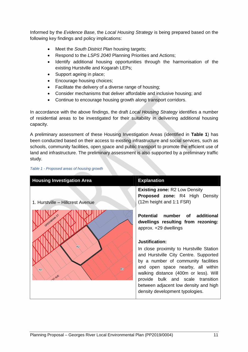
Table 1 - Proposed areas of housing growth
Housing Investigation Area Explanation
1. Hurstville – Hillcrest Avenue
Existing zone: R2 Low Density
Proposed zone: R4 High Density
(12m height and 1:1 FSR)
Potential number of additional
dwellings resulting from rezoning:
approx. +29 dwellings
Justification:
In close proximity to Hurstville Station
and Hurstville City Centre. Supported
by a number of community facilities
and open space nearby, all within
walking distance (400m or less). Will
provide bulk and scale transition
between adjacent low density and high
density development typologies.
Planning Proposal – Georges River Local Environmental Plan (PP2019/0004) 12
Housing Investigation Area Explanation
2. Penshurst – Apsley Estate
Existing zone: R2 Low Density
Proposed zone: R3 Medium Density
(9m height and 0.7:1 FSR)
Potential number of additional
dwellings resulting from rezoning:
approx. +183 dwellings
Justification:
In close proximity to both Hurstville and
Penshurst Stations, and the Hurstville
City Centre and Penshurst Local
Centre. Supported by a number of
community facilities and open space
nearby, all within walking distance
(400m or less).
3. Peakhurst – north and west of Peakhurst Park
Existing zone: R2 Low Density
Proposed zone: R3 Medium Density
(9m height and 0.7:1 FSR)
Potential number of additional
dwellings resulting from rezoning:
approx. +335 dwellings
Justification:
In close proximity to Riverwood Station
and Riverwood Local Centre.
Supported by open space nearby
(Peakhurst Park). Will provide bulk and
scale transition between adjacent low
density and high density development
typologies.
4. South Hurstville – Culwulla Street
Existing zone: R2 Low Density
Proposed zone: R3 Medium Density
(9m height and 0.7:1 FSR)
Potential number of additional
dwellings resulting from rezoning:
approx. +57 dwellings
Justification:
In close proximity to bus stops on King

Planning Proposal – Georges River Local Environmental Plan (PP2019/0004) 13
Housing Investigation Area Explanation
Georges Road that offer frequent bus
services to Hurstville Station.
Supported by South Hurstville Local
Centre, South Hurstville Library and a
number of open spaces nearby, which
are all within walking distance (400m or
less). Will provide bulk and scale
transition between adjacent low density
and high density development
typologies, and rationalise an existing
zoning anomaly.
5. South Hurstville – Greenacre Road
Existing zone: R2 Low Density
Proposed zone: R3 Medium Density
(9m height and 0.7:1 FSR)
Potential number of additional
dwellings resulting from rezoning:
approx. +48 dwellings
Justification:
In close proximity to frequent bus
services to Hurstville Station.
Supported by South Hurstville Local
Centre, South Hurstville Library and a
number of open spaces nearby, which
are all within walking distance (400m or
less). Rationalises an existing zoning
anomaly.
Targeted engagement was conducted with the property owners within and adjacent to
Housing Investigation Areas No.1, No.2, No.3 and No.4 between 3 September and 7
September 2019. They were invited to provide feedback on the proposed zoning and
associated built form controls for the purpose of informing the LSPS. These Areas have
been incorporated into the LSPS 2040 as “Potential New Housing in LEP 2020 – Housing &
Harmonisation”. Targeted engagement was not conducted for Housing Investigation Area
No.5 as this area was identified as an appropriate Housing Investigation Area by the
community during Stage 2 of the LSPS community consultation process.
Through the development of the Local Housing Strategy, an additional Housing Investigation
Area was proposed around Olds Park in Penshurst (refer to Table 2 below) which was also
subject to the targeted engagement process. However, further investigation indicated that
this area is not suitable for housing growth because of its existing traffic issues as
highlighted by the preliminary traffic study and the lack of accessibility to train stations and

Planning Proposal – Georges River Local Environmental Plan (PP2019/0004) 14
commercial centres. Accordingly, Council resolved to not proceed with the proposed up-
zoning of this Area at its meeting on 28 October 2019.
Table 2 – Olds Park Housing Investigation Area
Olds Park Housing Investigation Area Explanation
Existing zone: R2 Low Density
Proposed zone: R3 Medium Density
(9m height and 0.7:1 FSR)
Potential number of additional
dwellings resulting from rezoning:
approx. +219 dwellings
Justification:
Supported by open space (Olds Park)
and Penshurst Library.
The feedback and comments received from the targeted engagement sessions are currently
being considered by Council and will be incorporated into the Local Housing Strategy. The
traffic study will also be finalised where the impacts of the proposed dwelling increase within
each Housing Investigation Area will be assessed in relation to the road network.
Once the draft Local Housing Strategy is completed, endorsement will be sought from
Council to exhibit the Strategy as a supporting document with this Planning Proposal.
7.2 Draft Inclusive Housing Strategy
Council resolved on 27 November 2017 to commence the preparation of an Affordable
Rental Housing Policy and associated implementation plan for the Georges River LGA in
response to the Liveability Actions within the South District Plan. The Council resolution
required the:
a. Preparation of a framework for an Affordable Rental Housing Policy for the Georges
River LGA, including the preparation of an Affordable Rental Housing Target
Scheme, which considers the actions from the Draft Greater Sydney Region Plan
and the Revised Draft South District Plan.
b. Identification and assessment of housing issues within the City and the identification
of mechanisms to increase the supply of affordable housing for households on low to
moderate incomes in housing stress.
c. Provision of outcomes of the strategic research and implementation of the resultant
Policy provisions via Council’s planning framework (such as LEPs, DCPs, VPAs,
Section 94 Contributions Plans, etc) to increase the supply of affordable rental
housing in the City.

Planning Proposal – Georges River Local Environmental Plan (PP2019/0004) 15
Council in December 2018 commenced the preparation of the Inclusive Housing Strategy
and the supporting Delivery Plan for the Georges River LGA as part of a staged approach.
The key aims of the Inclusive Housing Strategy are:
To facilitate the provision of housing options to meet the needs of a wide range
of users, including seniors, people with a disability, students, key workers,
health visitors in the Kogarah Health and Education Precinct and the very low,
low and moderate income households within the residential market;
To develop planning controls and mechanisms that prevent the loss of existing
and the delivery of new supplies of affordable housing;
To advocate for, and build partnerships to increase affordable and liveable
housing; and
To explore options for managing affordable housing.
The Inclusive Housing Strategy - Stage 1 Report - Assessment of housing needs was
completed and endorsed by Council for public exhibition at its meeting dated 24 June 2019.
The Stage 1 Report highlights issues relating to housing cost, housing stress and the LGA’s
demography. It was publicly exhibited as a supporting document with the draft LSPS from 26
June to 7 August 2019.
In early 2019, the application of the State Environmental Planning Policy No 70 - Affordable
Housing (Revised Schemes) (SEPP 70) was expanded to include all NSW councils with the
intent of encouraging all NSW councils to investigate and develop an Affordable Housing
Contributions Scheme (AHCS) to promote the delivery and maintenance of affordable
housing.
The preparation of the final stage of the Inclusive Housing Strategy and the supporting
Delivery Plan is underway. The Delivery Plan includes the preparation of the AHCS, which
will set out how, where, and at what rate development contributions can be collected by
Council for affordable housing.
The draft Delivery Plan is based on the following goals:
Facilitate housing choice;
Establish a policy position that supports the delivery of inclusive housing; and
Facilitate the provision of affordable housing based on the following targets:
o 2020 to 2025: deliver 14 affordable dwellings per year (equating to
approx. 70 dwellings over 5 years)
o 2025 to 2030: deliver 24 affordable dwellings per year (equating to
approx. 120 dwellings over 5 years)
o 2030 to 2040: deliver 34 affordable dwellings per year (equating to
approx. 340 dwellings over 10 years)
The Inclusive Housing Strategy and the supporting Delivery Plan will inform the Stage 2
(Housing Choice) LEP in the staged LEP process. This Planning Proposal does not propose
the implementation of delivery mechanisms for affordable housing. However, the Strategy
will establish a policy position that affordable housing will be provided through planning
proposals and the associated voluntary planning agreement process in the short term with
exploration of provisions for affordable housing through infill development in future LEPs.

Planning Proposal – Georges River Local Environmental Plan (PP2019/0004) 16
Once the draft Inclusive Housing Strategy is completed, endorsement will be sought from
Council to exhibit the Strategy as a supporting document with this Planning Proposal.
7.3 Draft Commercial Centres Strategy
The Georges River Commercial Centres Strategy is currently being prepared in two parts
(Part 1 and Part 2) to support the staged approach to drafting the principal Georges River
LEP.
The draft Part 1 Centres Analysis was endorsed by Council at its meeting dated 24 June
2019 for public exhibition, and was publicly exhibited with the draft LSPS from 26 June to 7
August 2019. Part 1 Centres Analysis is currently being finalised with consideration of the
submissions received.
The primary purpose of this Part is to inform the preparation of the GRLEP 2020 and its
accompanying development control plan. This Part conducts a stocktake of all 48
commercial centres in the LGA through a holistic approach with the intention of harmonising
the existing planning frameworks that govern the future development of these centres.
Part 1 of the Strategy conducts a detailed economic analysis which projects the long term
employment floor space demand of all centres based on the future population growth,
through the preparation of the Commercial Centres Economic Study. This evidence base
has informed the development of a centres hierarchy based on the existing provision of retail
floor space within each centre. The hierarchy is comprised of 6 classifications with the
following breakdown:
2 Strategic centres
7 Local centres
5 Villages
10 Small villages
24 Neighbourhood centres
1 B6 Enterprise Corridor
Part 1 also looks at the inconsistencies and deficiencies of the current planning framework
with recommendations to harmonise the permissible land uses, to introduce land uses that
will promote employment in response to the emerging economic trends and drivers, and to
investigate the appropriate mix required between employment and residential floor space in
mixed use developments.
Part 2 of the Strategy is currently being prepared to inform Stage 2 of the LEP process.
Through a place-based planning approach, this Part will consider the roles and functions of
the commercial centres and provide centre-specific objectives, built form controls and
guidelines and investigate the potential expansion of appropriate centres.
7.4 Industrial Land Review
The Industrial Land Review was endorsed by Council at its meeting dated 17 December
2018. It provides a detailed analysis of industrial precincts in the LGA, including a detailed
demand and supply analysis of industrial lands and assessment of the suitability of each
industrial precinct for local and/or strategic industrial uses.

Planning Proposal – Georges River Local Environmental Plan (PP2019/0004) 17
The findings highlight the need for industrial land to be retained and managed across the
Georges River LGA in line with the policy direction of the South District Plan.
It also provides Council and landowners with a clear strategic direction for the development
of employment lands across the LGA to ensure that sufficient land is zoned to accommodate
future employment growth, particularly in light of pressure from landowners to rezone
industrial land.
7.5 Foreshore Study
The Foreshore Study is comprised of two studies that review the existing planning controls in
the foreshore localities of the Georges River through the lenses of environmental hazards
and local character. The key drivers for this Study are broadly summarised as follows:
Land use conflicts caused by the attraction of foreshore living and the loss of
scenic and environmental values through increased development and
subdivision;
Climate change and coastal inundation impacts such as sea level rise and the
risk to life and damage to property; and
Lack of coordinated directions for foreshore management within Council due to
the introduction of new State legislations which require local policy responses to
climate change and sea level rise.
The Foreshore Study will be exhibited with this Planning Proposal as a supporting
document.
Tidal Inundation Study
This Study determines the tidal inundation level in the Georges River foreshore at present
and for future timeframes through hydraulic modelling to map the extent of sea level rise.
Sea level rise is recognised as a significant coastal hazard with associated social, financial
and environmental risks. The extent of tidal inundation level identified by this Study has
informed the areas affected by future sea level rise shown on the proposed Coastal Hazard
and Risk Line Map.
Foreshore Strategic Directions Paper
This Paper evaluates the current policy framework to identify key issues, emerging directions
and key principles that will form the foundation for the preparation of new foreshore planning
controls.
As part of this Paper, a visual character assessment was undertaken of the foreshore
localities to the ridgelines (as viewed from the water) and waterways along the land and
water interface. As a result, the study area is categorised into distinct character areas (refer
to Figure 4 below) to allow for the designation of a rating system in terms of the overall
character value and the area’s sensitivity to change such as tree clearing, larger scale
development, altered geology through cut and fill, and the replacement of incongruous
development with contemporary styles.

Planning Proposal – Georges River Local Environmental Plan (PP2019/0004) 18
Figure 4:- Foreshore character typologies
The common characteristics and attributes of the character areas that are considered as
having a High or Very High sensitivity rating are high levels of tree coverage, steep or
undulating terrain with distinctive ridgelines, all with minimal visible built form.
These character typologies with High or Very High sensitivity ratings listed below generally
have an interface with the Georges River and are predominantly located along the waterfront
and towards the west of the study area:
Bush Suburban
Garden Suburban (larger lots)
Reserve Edge
Park Edge
Naturalistic Edge
Semi-Natural Edge
Naturalistic Headland
Character areas to the east of Georges River are largely assessed as having a lower
sensitivity rating. This is due to the flatter topography, lower vegetation coverage as a result
of contemporary developments and the dominant built form character.
The detailed character analysis conducted by this Paper has informed the preparation of the
proposed foreshore scenic protection area extent shown on the Foreshore Scenic Protection
Area Map.
Planning Proposal – Georges River Local Environmental Plan (PP2019/0004) 19
7.6 Infrastructure Integration Advice Roadmap
Preparation of advice to Council for infrastructure integration has been completed to inform
Council’s LSPS and the principal Georges River LEP.
The Infrastructure Integration Advice Roadmap conducts a gap analysis which identifies data
gaps in relation to economic, social and green infrastructure outcomes.
The Roadmap will assist Council in understanding the critical infrastructure that is required to
support housing and employment growth over the short, medium and long term in alignment
with the LSPS Actions. The data gaps that have not been able to be addressed in LSPS
2040 will be reviewed and considered as part of future policy work and/or work programs in
accordance with the commitment given at Council’s meeting on 28 October 2019.
7.7 Draft Hurstville Heritage Review
Council is currently preparing a review of the heritage items listed in Schedule 5
Environmental Heritage of the HLEP 2012. No review was conducted for heritage items
under the KLEP 2012 due to the recent review that was undertaken as part of the
preparation of Amendment No.2 to the KLEP 2012, known as the New City Plan, which was
gazetted on 26 May 2017.
The review comprises of three stages:
Stage 1 - Review of heritage items in the Hurstville CBD (approx. 47 items)
Stage 2 - Review of remaining heritage items (approx. 105 items)
Stage 3 - Revise statement of significance for all heritage items recommended for re-
listing
The Hurstville Heritage Review will be exhibited as a supporting document to this Planning
Proposal.
7.8 Hurstville City Centre Urban Design Study
The Hurstville City Centre Urban Design Strategy reviews the existing planning controls in
the Hurstville City Centre and recommends amended planning controls to in part provide a
logical approach to the built form controls, identify opportunities for additional housing
capacity within the Hurstville City Centre and reinforce the role of Hurstville as a gateway to
southern Sydney.
7.9 Open Space, Recreation and Community Facilities Strategy
2019-2036
The Open Space, Recreation and Community Facilities Strategy provides a high-level
direction for the provision of community centres, libraries, open space, sport and recreation
facilities, athletics and aquatic facilities in the LGA. The purpose of the Strategy is to
examine existing services and current demand, and determine the infrastructure needed
based on projected future population and demographic estimates for the LGA until 2036.

Planning Proposal – Georges River Local Environmental Plan (PP2019/0004) 20
7.10 Create Georges River Cultural Strategy 2019-2029
The Cultural Strategy provides a strategic focus for Council to develop and support arts and
culture within the LGA and sets out a framework for strengthening cultural activities and
initiatives. Planning policies and legislation will assist in achieving the actions within the
Cultural Strategy, including through the actions in the LSPS and planning controls in the
Georges River Principal LEP.

Planning Proposal – Georges River Local Environmental Plan (PP2019/0004) 21
Section B: The Planning Proposal
8. Part 1: Objectives or Intended Outcomes
The outcome of this Planning Proposal is a consolidated principal Georges River LEP which
implements the first stage of the staged LEP approach. With a focus on housing and
harmonisation, this LEP will ensure that a single consistent approach is applied to planning
and development across the LGA.
The objectives of this Planning Proposal are to:
Give effect to the South District Plan by addressing its Planning Priorities and
Actions;
Implement the LSPS 2040 vision for the LGA addressing its Planning Priorities
and Actions;
Meet the South District Plan housing targets;
Identify additional housing opportunities through the harmonisation of existing
LEPs;
Retain and manage industrial and urban services land;
Provide a regulatory environment that enables economic opportunities;
Protect future transport and infrastructure corridors;
Facilitate opportunities for creative and artistic industries; and
Identify, conserve and enhance environmental heritage.
9. Part 2: Explanation of the Provisions
The provisions in this Planning Proposal are in accordance with the Standard Instrument
(Local Environmental Plans) Order 2006 and are intended to harmonise and consolidate the
planning controls within the following LEPs currently in force across the Georges River LGA:
i. Kogarah Local Environmental Plan 2012 (KLEP 2012)
ii. Hurstville Local Environmental Plan 2012 (HLEP 2012)
iii. Hurstville Local Environmental Plan 1994 (HLEP 1994)
Where there is a fundamental difference between the LEPs, particularly in the case of the
land use tables and principal development standards, the Standard Instrument LEP (SILEP)
approach prevails and/or the provision has been adjusted so that a ‘best fit’ approach
applies.
This Planning Proposal has been prepared in accordance with a number of overarching
principles as outlined below:
Achieve equity across the LGA through the harmonisation process, particularly in
respect to development potential and the management of environmental hazards and
risks;

Planning Proposal – Georges River Local Environmental Plan (PP2019/0004) 22
Retain existing controls where the status quo can be maintained;
Develop a hierarchy of residential zones to ensure development typologies reflect the
objectives of the respective zone, including a ‘true’ medium density residential zone;
Protect the amenity and local character of low density residential zoned areas;
Provide high density residential areas with opportunities for greater activation;
Facilitate employment growth in centres, particularly in mixed use zones;
Protect industrial zoned land whilst allowing greater land use and development
flexibility;
Promote good design and environmentally sustainable practices in larger
developments;
Enhance and protect the natural environment, especially in the foreshore localities
along the Georges River;
Formalise key infrastructure uses such as schools and hospitals; and
Adopt the model local provisions for Standard Instrument LEPs as provided by the
DPIE where applicable.
The proposed contents of the GRLEP 2020 are as follows:
Part 1 – Preliminary
Clause 1.1 - Name of Plan
The Plan will be called the Georges River Local Environmental Plan 2020.
Clause 1.1AA Commencement
The Plan will commence on the day on which it is published on the NSW legislation
website.
Clause 1.2 – Aims of Plan
The aims of the Plan are a consolidation of the existing aims of the HLEP 2012 and
KLEP 2012 and new aims. The new aims ensure that the desired future direction for
the LGA as identified by the LSPS vision is directly captured in the GRLEP 2020.
Considerations such as housing choice, the viability and vibrancy of centres, a well-
designed and vegetated urban environment, the protection of the natural
environment, the provision of social infrastructure and an emphasis on transit-
oriented development are all captured within the proposed aims of the Plan.
The proposed aims of the Plan are:
a) To provide for housing choices to cater for changing demographics and
population needs,
b) To provide for a range of business uses which promote employment and
economic growth and contribute to the viability and vibrancy of centres,

Planning Proposal – Georges River Local Environmental Plan (PP2019/0004) 23
c) To promote and facilitate an ecologically and economically sustainable, well
designed and vegetated urban environment in which the needs and
aspirations of the community are realised,
d) To provide for a range of recreational, social, cultural and community service
opportunities to meet the needs of the Georges River community,
e) To protect and preserve the natural, built, cultural and Aboriginal heritage of
Georges River, to build upon and enhance the character of local areas,
f) To protect, preserve and enhance the natural landform, vegetation and open
space, especially foreshores or bushland, in order to maintain landscape
amenity and public access and use,
g) To facilitate infrastructure to support new development,
h) To promote and facilitate transit oriented development that encourages the
use of public transport, cycling and walking.
Clause 1.3 - Land to which Plan applies
The land to which the Plan applies will be shown on the Land Application Map and
includes the whole of the Georges River LGA.
Clause 1.4 Definitions
This clause will be as per the SILEP. The clause references the Dictionary to be
included at the end of the Plan to define certain words and expressions.
Clause 1.5 Notes
This clause will be as per the SILEP. This is an advisory clause only.
Clause 1.6 Consent authority
Council will be the consent authority for the purpose of the Plan (subject to the Act).
Clause 1.7 Maps
This clause will be as per the SILEP.
Clause 1.8 Repeal of planning instruments applying to land
This clause will be as per the SILEP.
Clause 1.8A Savings provisions relating to development applications
This clause will be as per the SILEP.
Clause 1.9 Application of SEPPs
This clause will be as per the SILEP.

Planning Proposal – Georges River Local Environmental Plan (PP2019/0004) 24
Clause 1.9A Suspension of covenants, agreements and instruments
This clause will be as per the SILEP.
Part 2 – Permitted or prohibited development
Part 2 provides information on permitted and prohibited development, including land use
zones and the application area for zones. Reference is also made to the Land Use Table,
which outlines the zone objectives, permitted land uses and prohibited land uses. Most items
in this part are compulsory clauses under the SILEP and must be included in the GRLEP
2020.
Clause 2.1 - Land use zones
This Planning Proposal does not seek to introduce any new zones or remove any
existing zones as applicable to the Georges River LGA. It does however propose to
rezone areas, as discussed later in this Planning Proposal. A comparison of the land
use zones included within the existing LEPs and proposed in the GRLEP 2020 is
provided in Table 3 below:
Table 3 – Existing vs Proposed Land Use Zones
GRLEP 2020 Land Use Zone HLEP 2012 KLEP 2012
Residential zones
R2 Low Density Residential Yes Yes
R3 Medium Density Residential Yes Yes
R4 High Density Residential No Yes
Business zones
B1 Neighbourhood Centre Yes Yes
B2 Local Centre Yes Yes
B3 Commercial Core Yes No
B4 Mixed Use Yes Yes
B6 Enterprise Corridor No Yes
Industrial zones
IN2 Light Industrial Yes Yes
Infrastructure zones
SP2 Infrastructure Yes Yes
Recreational zones
RE1 Public Recreation Yes Yes
RE2 Private Recreation Yes No
Environmental zones
E1 National Parks and Nature Reserves Yes No
E2 Environmental Conservation No Yes
Waterway zones
W2 Recreational Waterways Yes Yes

Planning Proposal – Georges River Local Environmental Plan (PP2019/0004) 25
Clause 2.2 - Zoning of land to which Plan applies
This clause will be as per the SILEP. The clause states that land is within the zones
shown on the Land Zoning Map.
Whilst this Planning Proposal does not seek to introduce any new zones or remove
any existing zones, it does propose to update the existing residential zones so an
appropriate residential hierarchy is developed to ensure development typologies
reflect the objectives of the respective zone. The proposed hierarchy of residential
density is outlined as follows:
Low density: dwelling houses and dual occupancies
Medium density: attached dwellings, multi dwelling housing, terraces and manor
houses
High density: residential flat buildings
Residential flat buildings are currently permitted as the prevailing typology in the R3
Medium Density Residential zones under the existing LEPs due to the generous
building height and floor space ratio applied. The GRLEP 2020 proposes to achieve
a hierarchy of residential density through the translation of all existing R3 Medium
Density Residential zoned land with a height of 12m or greater in both the HLEP
2012 and KLEP 2012 to the R4 High Density Residential zone where residential flat
buildings are currently permitted as the prevailing typology. These areas are shown
in Figure 5 below. No changes are proposed to the existing heights and FSRs of
these areas.
Figure 5: Location of proposed up-zonings from R3 to R4
Planning Proposal – Georges River Local Environmental Plan (PP2019/0004) 26
It should be noted that the existing LEPs contain some ‘true’ medium density areas in
the R3 Medium Density Residential zones as characterised by a maximum building
height of 9m. These areas will be retained as R3 Medium Density Residential zones
under the GRLEP 2020.
This Planning Proposal also incorporates the proposed zoning of the Housing
Investigation Areas (refer to Table 1 above) as identified by the draft Local Housing
Strategy. The Housing Investigation Areas will contribute to the provision of R3
Medium Density Residential zoned land in the Georges River LGA.
SP2 Infrastructure Rezoning
This Planning Proposal also seeks to harmonise and rezone some of the existing
SP2 Infrastructure zones as follows:
Rezone land that is currently identified as SP2 “Church” under the HLEP
2012 to the adjoining zone to ensure a consistent approach across the LGA.
If the adjoining zone does not permit places of public worship as a land use
then the property has been added to Schedule 1 of the LEP to enable place
of public worship as an additional permitted use;
Rezone land that is currently identified as SP2 “Aged Care” under the HLEP
2012 to the adjoining zone as seniors housing is permissible under the State
Environmental Planning Policy (Housing for Seniors or People with a
Disability) 2004;
Rezone land that is currently identified as SP2 “Community Purposes” under
the HLEP 2012 to the adjoining zone to ensure a consistent approach across
the LGA;
Review land that is currently identified as SP2 “Health Services Facilities”
under the KLEP 2012 and only retain SP2 “Hospitals” as per the HLEP 2012
to protect hospitals as significant infrastructure in the LGA; Rezone land that
is currently identified as SP2 “Public Administration” under the HLEP 2012 to
the adjoining zone to ensure a consistent approach across the LGA; and
Identify land across the LGA that is currently not zoned as SP2 but is owned
by education providers and operating as a school and rezone these
properties to SP2 “Educational establishments” to formalise the use of these
lands as schools and retain their use.
Deferred Matter
With respect to the three Deferred Matter sites under the HLEP 2012, this Planning
Proposal seeks to translate the HLEP 1994 provisions into the Standard Instrument
LEP form and allocate the proposed zones as follows.
Civic Precinct – proposed B4 Mixed Use
The Civic Precinct site (refer to Figure 6 below) is the subject of a current Planning
Proposal. It is proposed to translate the existing 3(b) – City Centre zoning to B4
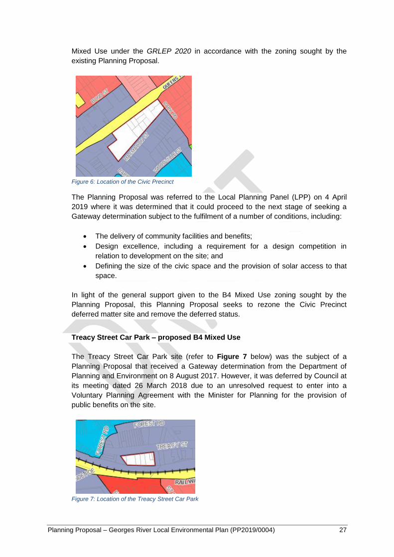
Planning Proposal – Georges River Local Environmental Plan (PP2019/0004) 27
Mixed Use under the GRLEP 2020 in accordance with the zoning sought by the
existing Planning Proposal.
Figure 6: Location of the Civic Precinct
The Planning Proposal was referred to the Local Planning Panel (LPP) on 4 April
2019 where it was determined that it could proceed to the next stage of seeking a
Gateway determination subject to the fulfilment of a number of conditions, including:
The delivery of community facilities and benefits;
Design excellence, including a requirement for a design competition in
relation to development on the site; and
Defining the size of the civic space and the provision of solar access to that
space.
In light of the general support given to the B4 Mixed Use zoning sought by the
Planning Proposal, this Planning Proposal seeks to rezone the Civic Precinct
deferred matter site and remove the deferred status.
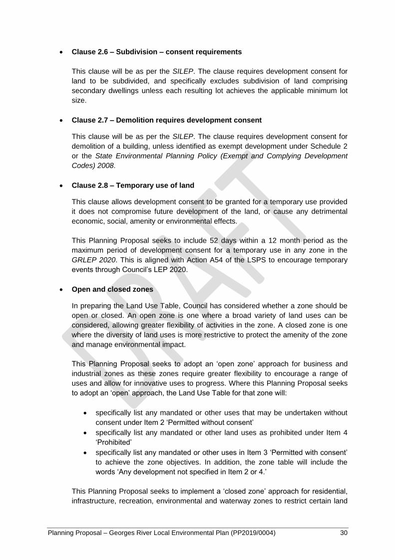
Treacy Street Car Park – proposed B4 Mixed Use
The Treacy Street Car Park site (refer to Figure 7 below) was the subject of a
Planning Proposal that received a Gateway determination from the Department of
Planning and Environment on 8 August 2017. However, it was deferred by Council at
its meeting dated 26 March 2018 due to an unresolved request to enter into a
Voluntary Planning Agreement with the Minister for Planning for the provision of
public benefits on the site.
Figure 7: Location of the Treacy Street Car Park

Planning Proposal – Georges River Local Environmental Plan (PP2019/0004) 28
At the meeting, Council also resolved to not proceed with the Planning Proposal for
this site as it will be incorporated into a future planning proposal prepared for the
Hurstville City Centre.
Accordingly, it is proposed to translate the existing 3(b) – City Centre zoning of the
site to B4 Mixed Use under the GRLEP 2020 in accordance with the zoning that was
approved by the Department of Planning and Environment in its Gateway
determination.
Westfield – proposed B3 Commercial Core
The Westfield site (refer to Figure 8 below) is the subject of a Planning Proposal
which was withdrawn by the proponent prior to the completion of the assessment
process.
Figure 8: Location of Westfields
In the absence of an active or Council endorsed planning proposal on the site, this
Planning Proposal seeks to apply a B3 Commercial Core zone on the site in
accordance with the existing commercial use. The proposed B3 Commercial Core
zoning is considered appropriate due to its consistency with the intent of the South
District Plan. As a strategic centre in the Greater Sydney region, the Hurstville City
Centre will benefit from the proposed B3 Commercial Core zoning of this site as
expanding the boundary of the commercial core will facilitate the attraction of
additional office and commercial floor space to the centre.
The South District Plan identifies employment growth as the principal underlying
economic goal for strategic centres, and outlines that the designation of a
commercial core within a strategic centre for economic and employment uses may be
necessary to manage the impact of residential developments on commercial activity.
Given the existing economic and employment uses on the site, the GRLEP 2020
proposes a B3 Commercial Core zoning to retain the Westfield site as a key
economic and employment generator in the Hurstville strategic centre.

Planning Proposal – Georges River Local Environmental Plan (PP2019/0004) 29
It should be noted that the development standards such as height of buildings and
floor space ratio for all of the above deferred matter sites will be translated from the
Hurstville Development Control Plan Number 2 - Amendment No. 5.
Clause 2.3 – Zone objectives and land use tables
This clause will be as per the SILEP. The clause references the Land Use Table and
requires the consent authority to have regard to the objectives for development in a
zone when determining a development application. There are mandatory objectives
prescribed by the SILEP for all zones. Council can include additional local objectives
where appropriate to supplement the mandatory objectives to cover additional local
issues such as land use conflicts, environmental impacts and amenity issues.
The proposed objectives for each land use zone are a combination of the core zone
objectives as mandated by the SILEP, an update of the consolidated objectives from
the existing LEPs, and new objectives that reflect the LSPS 2040 vision. In
accordance with the LEP Practice Note PN 09-005, no more than two to three local
zone objectives are proposed.
In summary, the local zone objectives seek to:
Promote a high standard of urban design and built form within a landscaped
setting in residential zones;
Encourage development that maximises public transport patronage and
promotes walking and cycling in the high density residential zone;
Ensure developments contribute to the vibrancy and economic viability of
commercial centres in business zones;
Encourage the provision of community facilities and public infrastructure in
business zones; and
Ensure land is protected and provided for community purposes in the
infrastructure zone.
Clause 2.4 – Unzoned Land
This clause will be as per the SILEP. The clause states that consent is required for
development on unzoned land.
Clause 2.5 – Additional permitted uses for particular land
This clause will be as per the SILEP. This clause allows the consent authority to
grant consent for particular development not otherwise permitted in a zone. This
clause refers to Schedule 1 which will include all additional permitted uses that
currently apply to land within the Georges River LGA. The proposed changes to
Schedule 1 are discussed later in this report.
Planning Proposal – Georges River Local Environmental Plan (PP2019/0004) 30
Clause 2.6 – Subdivision – consent requirements
This clause will be as per the SILEP. The clause requires development consent for
land to be subdivided, and specifically excludes subdivision of land comprising
secondary dwellings unless each resulting lot achieves the applicable minimum lot
size.
Clause 2.7 – Demolition requires development consent
This clause will be as per the SILEP. The clause requires development consent for
demolition of a building, unless identified as exempt development under Schedule 2
or the State Environmental Planning Policy (Exempt and Complying Development
Codes) 2008.
Clause 2.8 – Temporary use of land
This clause allows development consent to be granted for a temporary use provided
it does not compromise future development of the land, or cause any detrimental
economic, social, amenity or environmental effects.
This Planning Proposal seeks to include 52 days within a 12 month period as the
maximum period of development consent for a temporary use in any zone in the
GRLEP 2020. This is aligned with Action A54 of the LSPS to encourage temporary
events through Council’s LEP 2020.
Open and closed zones
In preparing the Land Use Table, Council has considered whether a zone should be
open or closed. An open zone is one where a broad variety of land uses can be
considered, allowing greater flexibility of activities in the zone. A closed zone is one
where the diversity of land uses is more restrictive to protect the amenity of the zone
and manage environmental impact.
This Planning Proposal seeks to adopt an ‘open zone’ approach for business and
industrial zones as these zones require greater flexibility to encourage a range of
uses and allow for innovative uses to progress. Where this Planning Proposal seeks
to adopt an ‘open’ approach, the Land Use Table for that zone will:
specifically list any mandated or other uses that may be undertaken without
consent under Item 2 ‘Permitted without consent’
specifically list any mandated or other land uses as prohibited under Item 4
‘Prohibited’
specifically list any mandated or other uses in Item 3 ‘Permitted with consent’
to achieve the zone objectives. In addition, the zone table will include the
words ‘Any development not specified in Item 2 or 4.’
This Planning Proposal seeks to implement a ‘closed zone’ approach for residential,
infrastructure, recreation, environmental and waterway zones to restrict certain land

Planning Proposal – Georges River Local Environmental Plan (PP2019/0004) 31
uses to protect the amenity of these areas and manage environmental impact. Where
this Planning Proposal seeks to adopt a ‘closed’ approach, the Land Use Table for
that zone will:
specifically list any mandated or other uses that may be undertaken without
consent under Item 2 ‘Permitted without consent’
specifically list any mandated or other land uses as permitted with consent
under Item 3 ‘Permitted with consent’ to achieve the zone objectives
specifically list any mandated land uses as prohibited in item 4 and add ‘Any
development not specified in Item 2 or 3’.
The adopted approach to the Land Use Table for the GRLEP 2020 is based on the
recommended approach in the DPIE’s LEP Practice Note PN 11-002 and the
principle of maintaining consistency and permissibility retention across the existing
LEPs as much as possible:
Table 2: Open and Closed Zones
Zone Approach to Land Use Table
Residential Zones
R2 Low Density Residential Closed
R3 Medium Density Residential Closed
R4 High Density Residential Closed
Business Zones
B1 Neighbourhood Centre Open
B2 Local Centre Open
B3 Commercial Core Open
B4 Mixed Use Open
B6 Enterprise Corridor Open
Industrial Zones
IN2 Light Industrial Open
Infrastructure Zones
SP2 Infrastructure Closed
Recreational Zones
RE1 Public Recreation Closed
RE2 Private Recreation Closed
Environmental Zones
E1 National Parks and Nature Reserves Closed
E2 Environmental Conservation Closed
Waterway Zones
W2 Recreational Waterways Closed
Planning Proposal – Georges River Local Environmental Plan (PP2019/0004) 32
Land Use Table
This Planning Proposal seeks to merge the Land Use Table provisions in the existing
LEPs to form a combined and consistent suite of land use zones.
In preparing the Land Use Table, a general rule of permissibility retention has been
used. This means that the permissible land uses in most zones proposed for the
GRLEP 2020 are a combination of the permissible land uses of the existing LEPs.
The proposed Land Use Table is not inconsistent with the existing LEPs.
The proposed Land Use Tables are set out (with objectives) in Appendix 1.
There are a number of notable changes to the Land Use Table proposed in response
to community feedback during the public exhibition of the LSPS and to align with the
LSPS vision as summarised below.
In the R2 Low Density Residential zone:
Permit boat sheds due to the significant number of R2 zoned properties
located on the waterfront;
Prohibit medium density dwellings such as attached dwellings and multi
dwelling housing in accordance with the principle of developing a hierarchy of
residential zones where medium density development is removed from the
low density zone to protect its character and amenity;
Prohibit places of public worship due to the adverse amenity impacts
considered to be generated by these uses. However, the existing places of
public worship will retain their use through the inclusion of these sites in
Schedule 1 Additional permitted uses.
The R3 Medium Density Residential zone prohibits residential flat buildings in
accordance with the principle of developing a hierarchy of residential zones where
high density development is removed from the medium density zone to protect the
character and amenity of the area.
The R4 High Density Residential zone permits hostels, hotel and motel
accommodation, restaurants or cafes, serviced apartments, shops, and small bars to
facilitate the creation of active places in areas with high residential density to improve
the liveability of apartment living and promote social interactions. These areas are
located in accessible locations that encourage walking and have the potential to
become destinations for shopping, dining and meeting people.
Permit artisan food and drink industries in all business zones to create lively centres
by expanding the types of retail and food offered.
The B1 Neighbourhood Centre zone permits service stations to remove these uses
from Schedule 1 Additional permitted uses under the HLEP 2012 and to recognise
these as an integral land use in servicing the local community.
Planning Proposal – Georges River Local Environmental Plan (PP2019/0004) 33
The B3 Commercial Core zone permits tourist and visitor accommodation to
accommodate the significant presence of international students and visitors staying
within the Hurstville City Centre.
The B4 Mixed Use zone permits helipads to support the existing medical presence in
the Kogarah Town Centre and Hurstville City Centre by enabling helicopters as a
form of emergency transportation.
In the B6 Enterprise Corridor zone, permit function centres, neighbourhood
supermarkets, restaurants or cafes, and small bars to facilitate the activation within
this zone.
The IN2 Light Industrial zone prohibits business premises to ensure industrial uses
remain as the primary land use in this zone. However, funeral homes are excluded
from this prohibition as they are considered to be an appropriate land use due to the
absence of sensitive land uses in this zone.
Part 3 Exempt and complying development
Clause 3.1 – Exempt development
This Planning Proposal does not seek to introduce any new controls for exempt
development. This Planning Proposal will not include any of the existing exempt
development listed in the KLEP 2012 or HLEP 2012 and rely upon the provisions of
the State Environmental Planning Policy (Exempt and Complying Development
Codes) 2008.
Clause 3.2 – Complying development
This Planning Proposal does not seek to introduce any new controls for complying
development. It relies upon the provisions of the State Environmental Planning Policy
(Exempt and Complying Development Codes) 2008 and is consistent with the
approach of the KLEP 2012 and HLEP 2012 which did not include any additional
types of complying development.
Clause 3.3 – Environmentally sensitive areas excluded
This clause will be as per the SILEP. The clause defines an ‘environmentally
sensitive area’ where exempt or complying development must not be carried out.
Part 4 – Principal development standards
Part 4 of the GRLEP 2020 provides key development standards relating to the use of land.
Many of the provisions are optional under the SILEP, but if adopted contain standard content
that can be tailored to local conditions. This Planning Proposal seeks to include a range of

Planning Proposal – Georges River Local Environmental Plan (PP2019/0004) 34
principal development standards in the GRLEP 2020 based on the overarching principles
identified earlier in this Planning Proposal.
An overview of the proposed clauses to be included in Part 4 of the GRLEP 2020 is provided
below. The key changes to the principal development standards and their detailed
justification is provided in Appendix 3.
Clause 4.1 - Minimum subdivision lot size
This clause allows Council to identify minimum subdivision lot sizes for the LGA on the
Lot Size Map in the GRLEP 2020.
The HLEP 2012 and KLEP 2012 contain different objectives for this clause. This
Planning Proposal seeks to include a consolidated and consistent set of clause
objectives in the GRLEP 2020, as follows:
a) to ensure that new lots created have sufficient area for development to comply with
the relevant development standards and controls,
b) to ensure that subdivision reflects the subdivision pattern of the area,
c) to ensure lot size reflects the land’s environmental capability with consideration to
topography and other natural features.
This Planning Proposal seeks to adopt the following minimum lot sizes for dwelling
houses in the R2 zone:
Within the Foreshore Scenic Protection Area (FSPA) – 700sqm
All other areas – 450sqm
This Planning Proposals seeks to retain the 1,000sqm minimum subdivision lot size
within the R4 zone to prevent the fragmentation of lots.
This Planning Proposal seeks to introduce a minimum subdivision lot size of 1,000sqm
within the former Hurstville LGA industrial zones except for the Kingsgrove Industrial
Precinct and part of the Peakhurst Industrial Precinct which will be subject to a
2,500sqm minimum subdivision lot size.
It is also proposed to amend the minimum subdivision lot size from 750sqm to
1,000sqm in the following IN2 zoned areas in the former Kogarah LGA:
Halstead Street, South Hurstville
King Georges Road, Blakehurst
Carlton Industrial Estate
The KLEP 2012 current applies a minimum lot size for all B1, B2 and B6 zoned
properties. This Planning Proposal does not seek to translate this control into the
GRLEP 2020 and will adopt the HLEP 2012 approach which does not apply minimum
subdivision lot sizes in business zones.
Planning Proposal – Georges River Local Environmental Plan (PP2019/0004) 35
Clause 4.1AA – Minimum subdivision lot size for community title schemes
This Planning Proposal does not propose to adopt this clause, which is consistent with
the existing LEPs.
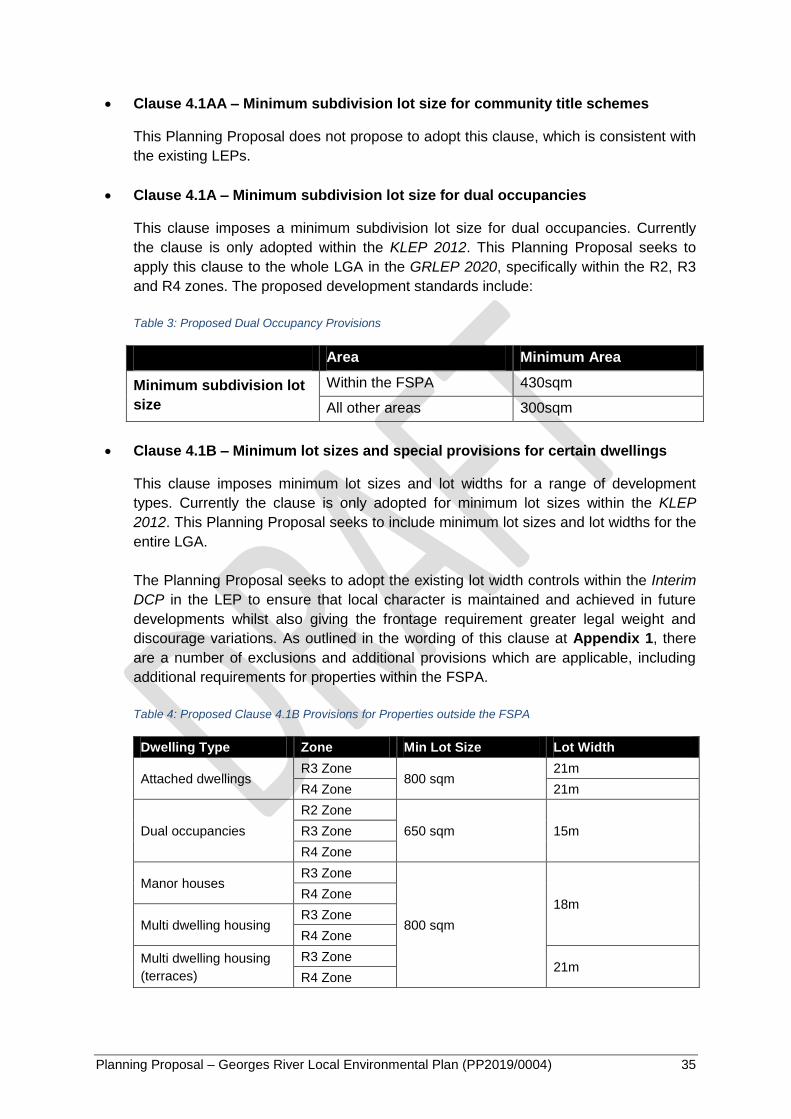
Clause 4.1A – Minimum subdivision lot size for dual occupancies
This clause imposes a minimum subdivision lot size for dual occupancies. Currently
the clause is only adopted within the KLEP 2012. This Planning Proposal seeks to
apply this clause to the whole LGA in the GRLEP 2020, specifically within the R2, R3
and R4 zones. The proposed development standards include:
Table 3: Proposed Dual Occupancy Provisions
Area Minimum Area
Minimum subdivision lot
size
Within the FSPA 430sqm
All other areas 300sqm
Clause 4.1B – Minimum lot sizes and special provisions for certain dwellings
This clause imposes minimum lot sizes and lot widths for a range of development
types. Currently the clause is only adopted for minimum lot sizes within the KLEP
2012. This Planning Proposal seeks to include minimum lot sizes and lot widths for the
entire LGA.
The Planning Proposal seeks to adopt the existing lot width controls within the Interim
DCP in the LEP to ensure that local character is maintained and achieved in future
developments whilst also giving the frontage requirement greater legal weight and
discourage variations. As outlined in the wording of this clause at Appendix 1, there
are a number of exclusions and additional provisions which are applicable, including
additional requirements for properties within the FSPA.
Table 4: Proposed Clause 4.1B Provisions for Properties outside the FSPA
Dwelling Type Zone Min Lot Size Lot Width
Attached dwellings R3 Zone
800 sqm 21m
R4 Zone 21m
Dual occupancies
R2 Zone
650 sqm 15m R3 Zone
R4 Zone
Manor houses R3 Zone
800 sqm
18m R4 Zone
Multi dwelling housing R3 Zone
R4 Zone
Multi dwelling housing
(terraces)
R3 Zone 21m
R4 Zone

Planning Proposal – Georges River Local Environmental Plan (PP2019/0004) 36
Clause 4.2 – Rural subdivision
This Planning Proposal does not propose to adopt this clause, which is consistent with
the existing LEPs.
Clause 4.3 – Height of buildings
This clause allows Council to identify building heights for the Georges River LGA on a
Height of Buildings Map in the LEP.
Currently the HLEP 2012 and KLEP 2012 contain different objectives for this clause.
This Planning Proposal seeks to include a consolidated and consistent set of clause
objectives in the GRLEP 2020 as follows:
a) to ensure that buildings are compatible with the height, bulk and scale of the
existing and desired future character of the locality,
b) to minimise the impact of overshadowing, visual impact, disruption of views and
loss of privacy on adjoining properties and open space areas,
c) to ensure that developments provide appropriate height transition to adjoining land
use zones,
d) to ensure that developments provide appropriate height transition to items and
areas of heritage significance.
This Planning Proposal does not seek to amend the height provisions for residential
development. It is proposed to incorporate the existing heights, which range from 9m
to 33m, into the GRLEP 2020. It is proposed to rezone all existing R3 zoned land with
heights of 12m or greater to the R4 zone but retain their existing height limit.
Under this Planning Proposal, one site in the LGA, located at 821 Forest Road,
Peakhurst will be zoned RE2. This site currently does not have a height limit under the
HLEP 2012 but it is proposed to allocate a 12m height limit to this site to ensure
development on this site is compatible with the surrounding area.
It is also proposed to amend the height controls of the IN2 zone to 12m except for the
Kingsgrove Industrial Precinct and part of Peakhurst Industrial Precinct where the
height control will be increased to 16m. The increase in heights enables industrial lots
to achieve an FSR of 1:1 and provide flexibility in built form for different land uses.
Further justification for this amendment can be found in Appendix 3.
The increase to 16m is appropriate at Kingsgrove as it has a limited interface with
residential zones. Whilst the Peakhurst Industrial Precinct does have a residential
interface, this Planning Proposal seeks to apply the lower height control of 12m to the
perimeter of the Precinct.
No changes are proposed to the existing height of business zoned land.
Clause 4.3A – Exceptions to height of buildings
Planning Proposal – Georges River Local Environmental Plan (PP2019/0004) 37
This clause outlines exceptions to the height of buildings provision, including:
R3 and R4 zones – the maximum height for dual occupancies is 9m.
Multi-dwelling housing – the maximum height is 5m for any dwelling that is
adjacent to a rear boundary. This control is proposed to complement the
objectives of this clause in ensuring appropriate transition is provided between
medium and low density residential zones, including mitigating any overshadowing
and privacy impacts on adjoining properties.
Clause 4.4 – Floor space ratio
This clause allows Council to identify floor space ratios for certain zones or
development types within the Georges River LGA on the Floor Space Ratio Map in the
LEP.
Currently the HLEP 2012 and KLEP 2012 contain different objectives for this clause.
This Planning Proposal seeks to include a consolidated and consistent set of clause
objectives in the GRLEP 2020 as follows:
a) to ensure that buildings are compatible with the bulk and scale of the existing
and desired future character of the local area,
b) to ensure that developments provide appropriate built form transition to adjoining
land use zones,
c) to ensure that developments provide appropriate built form transition to items
and areas of heritage significance,
d) to control development density and intensity of land use, taking into account:
i) the environmental constraints and values of the site, including retaining
the scenic, visual, and landscape qualities of the area, and
ii) the amenity of adjoining land and the public domain, and
iii) the availability of infrastructure to service the site, and
iv) the capacity of the road network to accommodate the vehicular and
pedestrian traffic the development will generate.
This Planning Proposal seek to amend the height provisions for residential
development as discussed below in Clause 4.4A (Exceptions to floor space ratio for
certain dwellings).
An FSR control will also be introduced to the one RE2 site proposed under the GRLEP
2020 at 821 Forest Road, Peakhurst. This site currently does not have a FSR under
the HLEP 2012 but it is proposed to allocate a 1:1 FSR to this site to ensure
development on this site is compatible with the surrounding area.
No changes are proposed to the existing FSR of IN2 zoned land and business zoned
land.
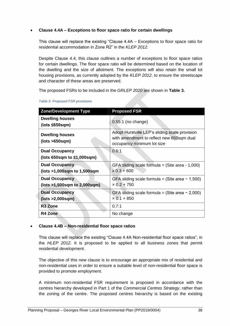
Planning Proposal – Georges River Local Environmental Plan (PP2019/0004) 38
Clause 4.4A – Exceptions to floor space ratio for certain dwellings
This clause will replace the existing “Clause 4.4A – Exceptions to floor space ratio for
residential accommodation in Zone R2” in the KLEP 2012.
Despite Clause 4.4, this clause outlines a number of exceptions to floor space ratios
for certain dwellings. The floor space ratio will be determined based on the location of
the dwelling and the size of allotment. The exceptions will also retain the small lot
housing provisions, as currently adopted by the KLEP 2012, to ensure the streetscape
and character of these areas are preserved.
The proposed FSRs to be included in the GRLEP 2020 are shown in Table 3.
Table 5: Proposed FSR provisions
Zone/Development Type Proposed FSR
Dwelling houses
(lots ≤650sqm) 0.55:1 (no change)
Dwelling houses
(lots >650sqm)
Adopt Hurstville LEP’s sliding scale provision
with amendment to reflect new 650sqm dual
occupancy minimum lot size
Dual Occupancy
(lots 650sqm to ≤1,000sqm)
0.6:1
Dual Occupancy
(lots >1,000sqm to 1,500sqm
GFA sliding scale formula = (Site area - 1,000)
x 0.3 + 600
Dual Occupancy
(lots >1,500sqm to 2,000sqm)
GFA sliding scale formula = (Site area − 1,500)
× 0.2 + 750
Dual Occupancy
(lots >2,000sqm)
GFA sliding scale formula = (Site area − 2,000)
× 0.1 + 850
R3 Zone 0.7:1
R4 Zone No change
Clause 4.4B – Non-residential floor space ratios
This clause will replace the existing “Clause 4.4A Non-residential floor space ratios”, in
the HLEP 2012. It is proposed to be applied to all business zones that permit
residential development.
The objective of this new clause is to encourage an appropriate mix of residential and
non-residential uses in order to ensure a suitable level of non-residential floor space is
provided to promote employment.
A minimum non-residential FSR requirement is proposed in accordance with the
centres hierarchy developed in Part 1 of the Commercial Centres Strategy, rather than
the zoning of the centre. The proposed centres hierarchy is based on the existing
Planning Proposal – Georges River Local Environmental Plan (PP2019/0004) 39
provision of retail floor space within each centre. Further justification for the inclusion
of this control can be found in Appendix 3.
Clause 4.5 – Calculation of floor space ratio and site area
This clause will be as per the SILEP. The clause sets out additional provisions for the
purposes of applying floor space ratios to development sites.
Clause 4.6 – Exceptions to development standards
This clause will be as per the SILEP. The clause allows for development consent to be
granted even though the development would contravene a development standard
imposed by this or any other environmental planning instrument.
In this case, the term “development standards” is defined by the EP&A Act as follows:
development standards means provisions of an environmental planning instrument
or the regulations in relation to the carrying out of development, being provisions by or
under which requirements are specified or standards are fixed in respect of any aspect
of that development, including, but without limiting the generality of the foregoing,
requirements or standards in respect of:
(a) the area, shape or frontage of any land, the dimensions of any land,
buildings or works, or the distance of any land, building or work from any
specified point,
(b) the proportion or percentage of the area of a site which a building or work
may occupy,
(c) the character, location, siting, bulk, scale, shape, size, height, density,
design or external appearance of a building or work,
(d) the cubic content or floor space of a building,
(e) the intensity or density of the use of any land, building or work,
(f) the provision of public access, open space, landscaped space, tree
planting or other treatment for the conservation, protection or
enhancement of the environment,
(g) the provision of facilities for the standing, movement, parking, servicing,
manoeuvring, loading or unloading of vehicles,
(h) the volume, nature and type of traffic generated by the development,
(i) road patterns,
(j) drainage,
(k) the carrying out of earthworks,
(l) the effects of development on patterns of wind, sunlight, daylight or
shadows,
(m) the provision of services, facilities and amenities demanded by
development,
(n) the emission of pollution and means for its prevention or control or
mitigation, and
(o) such other matters as may be prescribed.
Planning Proposal – Georges River Local Environmental Plan (PP2019/0004) 40
With consideration of the above, a number of local provisions are proposed to be
excluded from the application of Clause 4.6 due to the similarity in their application to
Clause 5.4 Controls relating to miscellaneous permissible uses, which cannot be
varied through Clause 4.6 as mandated by the SILEP. It is proposed that the following
provisions be excluded from the application of this clause:
Clause 6.13 – Development for the purposes of dual key dwellings in Zones R2
and R3
Clause 6.15 – Office premises in Zone IN2
Clause 6.16 – Take away food and drink premises and restaurants or café in
Zone IN2
It is proposed that the development standards within these provisions be prevented
from being varied under Clause 4.6 to ensure appropriate development outcomes in
residential and industrial areas.
An explanation of these provisions is provided below in Part 6 – Additional Local
Provisions of this Planning Proposal.
Part 5 – Miscellaneous provisions
Part 5 of the SILEP provides a series of miscellaneous provisions, of which some are
compulsory and some are optional.
This Planning Proposal seeks to retain the miscellaneous provisions identified in the existing
LEPs with the exception of the following optional SILEP clauses which do not currently add
any value to the merit-based development assessment process:
Clause 5.3 Development near zone boundaries
Clause 5.3 currently only applies to the SP2 Infrastructure zone in both existing LEPs
and enables land uses which are permissible within an adjoining zone to be permissible
within a SP2 zone. The permissibility of non-infrastructure land uses in the SP2 zone
may compromise the provision of infrastructure to service the community.
Accordingly, the retention of this clause within the GRLEP 2020 is considered to be
inconsistent with the intent of the LSPS which seeks to deliver infrastructure, services
and facilities.
Clause 5.6 Architectural roof features
Clause 5.6 is in both existing LEPs to permit roof features that exceed the maximum
building height if they display architectural design excellence.
This clause is proposed to be removed in the GRLEP 2020 as architectural design
excellence considerations in general will be subject to the provisions of a new design
excellence local provision. The proposed local provision provides a more comprehensive
assessment of the merits of a development, including those that seek to exceed the
Planning Proposal – Georges River Local Environmental Plan (PP2019/0004) 41
maximum building height. Further detail regarding the proposed design excellence local
provision is provided below in Part 6 – Additional Local Provisions of this Planning
Proposal.
An explanation of proposed clauses to be included in Part 5 of the GRLEP 2020 is provided
below.
Clause 5.1 Relevant acquisition authority
This clause will be as per the SILEP.
The HLEP 2012 and KLEP 2012 include land acquisitions for RE1 Local open space,
RE1 Regional open space and SP2 Classified road. These land acquisitions have been
translated into the GRLEP 2020 with the exception of sites that have already been
acquired by the relevant authority. These have been removed from the Land
Reservation Acquisition Map in the LEP.
This Planning Proposal also seeks to include four new land acquisitions by Council for
local road widening and the provision of open space as follows:
Local Road Widening
A 3m wide local road widening along Roberts Lane, Hurstville, to enable two-way
vehicle access, access for service vehicles such as delivery and waste collection
trucks, and the provision of a continuous pedestrian footpath with street planting on
Roberts Lane to support the future redevelopment of the Landmark Square Precinct,
an area subject to a separate planning proposal for increased densities at the
eastern bookend of the Hurstville City Centre.
Land reservation acquisition is only applied to 53 Forest Road, 9 Roberts Lane and
108 Durham Street, and excludes the portion located at 61-65 Forest Road as this
portion is proposed to be dedicated to Council as part of the Voluntary Planning
Agreement associated with the Landmark Square Precinct Planning Proposal (refer
to Figure 9 below).
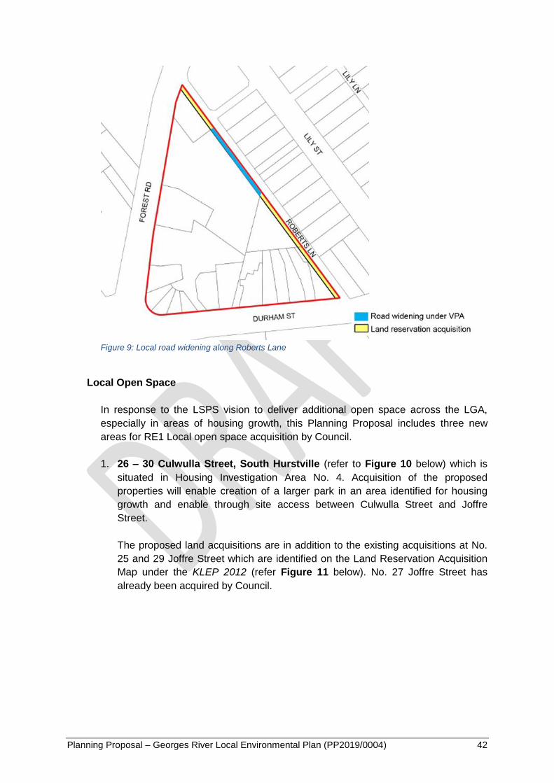
Planning Proposal – Georges River Local Environmental Plan (PP2019/0004) 42
Figure 9: Local road widening along Roberts Lane
Local Open Space
In response to the LSPS vision to deliver additional open space across the LGA,
especially in areas of housing growth, this Planning Proposal includes three new
areas for RE1 Local open space acquisition by Council.
1. 26 – 30 Culwulla Street, South Hurstville (refer to Figure 10 below) which is
situated in Housing Investigation Area No. 4. Acquisition of the proposed
properties will enable creation of a larger park in an area identified for housing
growth and enable through site access between Culwulla Street and Joffre
Street.
The proposed land acquisitions are in addition to the existing acquisitions at No.
25 and 29 Joffre Street which are identified on the Land Reservation Acquisition
Map under the KLEP 2012 (refer Figure 11 below). No. 27 Joffre Street has
already been acquired by Council.

Planning Proposal – Georges River Local Environmental Plan (PP2019/0004) 43
Figure 10: Location of 26-30 Culwulla Street, South Hurstville
Figure 11: Extract of the existing Land Reservation Acquisition Map identifying No. 25 and 29 Joffre
Street (KLEP 2012)
2. 11 – 21 Monaro Avenue, Kingsgrove (refer to Figure 12 below) which
comprises half of the eastern street block surrounding Peter Lowe Reserve.
Acquisition of the proposed properties will enable the expansion of the existing
reserve and facilitate improved access to the park, safety and public surveillance.
These properties have been identified as the most appropriate for acquisition due
to their location being at the end of McGregor Street. McGregor Street offers on-
street car parking which makes it a suitable entrance to the Reserve. The
acquisition of these properties will also provide direct visual sight lines to the
largest portion of the park to ensure a sufficient level of public surveillance into
the Reserve.

Planning Proposal – Georges River Local Environmental Plan (PP2019/0004) 44
Figure 12: Location of 11-21 Monaro Avenue, Kingsgrove
3. 7 Hedley Street, Riverwood and 13-15 Keith Street, Peakhurst (refer to
Figure 13 below) which are located at the north eastern end of Peakhurst Park.
Acquisition of the proposed properties will enable expansion of the park in an
area identified for housing growth (Housing Investigation Area No. 3) and
facilitate improved access to the park.
Figure 13: Location of 7 Hedley Street, Riverwood and 13-15 Keith Street, Peakhurst
The funding sources for the current acquisitions as specified by the existing LEPs
and additional acquisitions proposed by the GRLEP 2020 will be considered as part
of the preparation of the Georges River Development Contributions Plan. The new
development contributions plan is currently being prepared in parallel with the LSPS
2040 and GRLEP 2020 and is anticipated to be finalised in June 2020.

Planning Proposal – Georges River Local Environmental Plan (PP2019/0004) 45
Clause 5.2 Classification and reclassification of public land
This clause will be as per the SILEP. The clause enables Council to classify or
reclassify public land as operational land or community land in accordance with the
Local Government Act 1993. The land to be reclassified or classified is described in
Schedule 4 of the LEP.
This Planning Proposal does not seek to classify or reclassify any public land.
Accordingly, Schedule 4 of the GRLEP 2020 will not be populated but may be used
during the life of the LEP should changes to public land classification be adopted by
Council.
Clause 5.4 Controls relating to miscellaneous permissible uses
This clause is prescribed by the SILEP and enables Council to insert numerical
standards for certain types of development to reflect the unique characteristics of the
LGA.
Existing controls are retained where they are consistent in both the HLEP 2012 and
KLEP 2012.
The controls prescribed for the following miscellaneous permissible uses under the
existing LEPs are inconsistent and require harmonisation under the GRLEP 2020.
Industrial retail outlets
Kiosks
Neighbourhood shops
Secondary dwellings
Artisan food and drink industry exclusion
The more generous of the two existing controls for industrial retail outlets, kiosks,
neighbourhood shops, and artisan food and drink industries has been adopted to
support employment generating land uses.
However, a maximum 10% of total floor area as specified by the HLEP 2012 is
retained in the GRLEP 2020 for secondary dwellings. This is intended to achieve
consistency with the requirement specified by the State Environmental Planning Policy
(Affordable Rental Housing) 2009 by ensuring that the total floor area of the secondary
dwelling does not exceed 60sqm.
This Planning Proposal seeks to adopt the following development standards for
miscellaneous permissible use controls in the GRLEP 2020 as tabulated below:

Planning Proposal – Georges River Local Environmental Plan (PP2019/0004) 46
Table 7: Miscellaneous Permissible Uses
Land Use Development Standard
Bed and breakfast
accommodation No more than 3 bedrooms.
Home businesses Maximum 30 square metres of floor area.
Home industries Maximum 30 square metres of floor area.
Industrial retail outlets
The retail floor area must not exceed:
(a) 20% of the gross floor area of the industry or rural industry
located on the same land as the retail outlet, or
(b) 400 square metres,
whichever is the lesser.
Farm stay
accommodation No more than 3 bedrooms.
Kiosks The gross floor area must not exceed 15 square metres.
Neighbourhood shops The retail floor area must not exceed 100 square metres.
Neighbourhood
supermarkets The gross floor area must not exceed 100 square metres.
Roadside stalls The gross floor area must not exceed 8 square metres.
Secondary dwellings
The total floor area of the dwelling (excluding any area used for
parking) must not exceed whichever of the following is the
greater:
(a) 60 square metres,
(b) 10% of the total floor area of the principal dwelling.
Artisan food and drink
industry exclusion
In an industrial or rural zone, the floor area used for retail sales
(not including any cafe or restaurant area) must not exceed:
(a) 20% of the gross floor area of the industry, or
(b) 400 square metres,
whichever is the lesser.
Clause 5.7 - Development below mean high water mark
This clause will be as per the SILEP.
Clause 5.8 - Conversion of fire alarms
This clause will be as per the SILEP. The clause specifies when consent is required for
the conversion of fire alarm systems, and which development is complying
development.
Clause 5.10 Heritage conservation
Planning Proposal – Georges River Local Environmental Plan (PP2019/0004) 47
This clause is compulsory and will be as per the SILEP. The objective of the clause is
to conserve the environmental heritage of the LGA, including individual items,
conservation areas, archaeological sites, Aboriginal objects and Aboriginal places of
heritage significance. The clause is consistent across the existing LEPs. Heritage
items and conservation areas will be listed and described in Schedule 5 of the GRLEP
2020 and shown on the Heritage Map. Further details on the proposed changes to the
heritage items listed are outlined below in the explanation of Schedule 5.
Clause 5.11 Bushfire hazard reduction
This clause is compulsory and will be as per the SILEP. The clause makes it clear that
bush fire hazard reduction work which is authorised by the Rural Fires Act 1997 can be
carried out without consent.
Clause 5.12 Infrastructure development and use of existing buildings of the
Crown
This clause is compulsory and will be as per the SILEP. The clause specifies that
nothing in the Plan in any way restricts or prohibits permitted or exempt development
undertaken by or on behalf of a public authority under State Environmental Planning
Policy (Infrastructure) 2007.
Clause 5.19 Pond-based, tank-based and oyster aquaculture
This clause is compulsory and will be as per the SILEP and is required following the
repeal of State Environmental Planning Policy No 62—Sustainable Aquaculture. The
clause seeks to encourage sustainable oyster, pond-based and tank-based
aquaculture in the State. Location and operational requirements for permissible pond-
based and tank-based aquaculture development are set out in Schedule 6 of the LEP.
Part 6 – Local Provisions
Part 6 of the SILEP provides the opportunity for additional specialised provisions to be
inserted to address local issues.
This Planning Proposal seeks to include a range of local provisions in the GRLEP 2020
based on the Overarching Principles as outlined above in this report.
In preparing the proposed local provisions, a number of clauses are able to be harmonised
through the utilisation of model local provisions released by the DPIE where applicable and
the retention of local provisions in the existing LEPs. At the same time, this Planning
Proposal proposes significant amendments to some existing local provisions and proposes a
number of new specialised provisions to give effect to the South District Plan and to meet
the LSPS vision for the LGA,.
The following clauses contained in the HLEP 2012 or KLEP 2012 will not be adopted within
the GRLEP 2020:

Planning Proposal – Georges River Local Environmental Plan (PP2019/0004) 48
Clause 6.5 Gross floor area of dwellings in residential zones (HLEP 2012) as this
clause has been replaced by Clause 4.4A (Exceptions to floor space ratio for certain
dwellings).
Clause 6.6 Active street frontages (HLEP 2012) as the intent of this clause is now
achieved by the expansion of the minimum non-residential FSR and the proposed
Clause 6.14 (Development in certain business zones).
Clause 6.8 Seniors housing – self-contained dwellings in Zone R2 (KLEP 2012) as the
intent and application of this clause has now been expanded and replaced by Clause
6.13 (Dual key dwellings in Zones R2 and R3) which seeks to encourage self-
contained dual key dwellings of up to 75sqm within the principal dwelling to increase
housing supply and diversity.
Clause 6.9 Development in Zone B6 (KLEP 2012) as the intent of this clause is now
incorporated within the proposed Clause 6.14 (Development in certain business
zones).
All proposed local provisions have been prepared with the understanding that Clause 4.6
may be utilised to excuse non-compliance with a development standard, including those
specified in Part 6 of the LEP. In this case, the term “development standards” is defined by
the EP&A Act as provided above.
As discussed above, the following local provisions are proposed to be excluded from the
application of Clause 4.6 due to the similarity in their application to Clause 5.4 Controls
relating to miscellaneous permissible uses, which cannot be varied through Clause 4.6 as
mandated by the SILEP, and to ensure appropriate development outcomes in residential and
industrial areas:
Clause 6.13 – Development for the purposes of dual key dwellings in Zones R2
and R3
Clause 6.15 – Office premises in Zone IN2
Clause 6.16 – Take away food and drink premises and restaurants or café in Zone
IN2
All proposed local provisions, along with their justification, are provided in Appendix 4. An
overview of proposed clauses to be included in Part 6 of the GRLEP 2020 is provided below.
Clause 6.1 Acid sulfate soils
This clause seeks to ensure that development does not disturb, expose or drain acid
sulfate soils and cause environmental damage.
The proposed clause is based on the model local clause provided by the DPIE and is
generally consistent across the existing LEPs except that the KLEP 2012 adopts a
smaller distance (100m rather than the standard 500m) for works on Class 5 Land.
This Planning Proposal seeks to adopt the 500m distance control for Class 5 land
works in the GRLEP 2020, as specified in the model clause to provide a consistent
approach across the whole LGA.

Planning Proposal – Georges River Local Environmental Plan (PP2019/0004) 49
Clause 6.2 Earthworks
This clause seeks to ensure that earthworks for which development consent is
required will not have a detrimental impact on environmental functions and
processes, neighbouring uses and amenity, cultural or heritage items or features of the
surrounding land. It also allows earthworks of a minor nature without requiring
separate development consent.
This clause currently only applies to the former Kogarah LGA under the KLEP 2012
but it is proposed to extend its application to the entire Georges River LGA, to ensure
consistency in the assessment of earthworks and the impact of works on the integrity
of adjoining properties.
This local provision will mean that any development application will need to consider
the impact of proposed excavation on matters, such as soil stability, soil erosion, the
amenity and structural integrity of adjoining properties, and the health and vitality of
existing trees. Developments will also need to be designed to complement the slope of
the land to minimise the need for cut and fill and their potential height and bulk.
Clause 6.3 Flood planning
This clause seeks to minimise the flood risk to life and property associated with the
use of land, whilst allowing development that is compatible with the flood hazard,
taking into account projected changes as a result of climate change to avoid significant
adverse impacts on flood behaviour and the environment.
The clause is currently only adopted in the KLEP 2012 which identifies “flood planning
areas” on the Flood Planning Map. This Planning Proposal seeks to expand the
application of this clause to the whole LGA to ensure that all developments incorporate
appropriate measures to manage flood hazards consistently across the LGA where
there are known potential risks of flooding through the inclusion of two additional layers
– a new “flood planning zone” to the Flood Planning Map and a new Probable
Maximum Flood Map that shows the following information:
Probable Maximum Flood Extent;
Flood Prone Land; and
Flood Prone Zone.
The proposed Flood Planning Map and Probable Maximum Flood Map are provided in
Appendix 7.
The flood planning zone applies to properties that are identified as affected by the 1 in
100 year flood extent in Council’s overland flow flood studies. Council has endorsed
the following overland flow flood studies:
Overland Flow Flood Study for Hurstville, Mortdale and Peakhurst Wards – this
covers all areas within the former Hurstville LGA; and
Planning Proposal – Georges River Local Environmental Plan (PP2019/0004) 50
Moore Reserve Catchment Overland Flow Study – this covers the Moore
Reserve study area in the former Kogarah LGA.
A flood study is the first step in developing a floodplain risk management plan and
involves a comprehensive technical investigation of flood behaviour within an area.
Flood planning areas, such as the areas identified in the KLEP 2012 Flood Planning
Map, are properties that have been formally identified as affected by the 1 in 100 year
flood extent and have had the flood risk confirmed by the preparation of an endorsed
floodplain risk management study and plan.
It should be noted that a floodplain risk management study and plan has not been
completed for the proposed flood planning zones. Council is currently preparing a
Floodplain Risk Management Study and Plan (“the Plan”) for the Hurstville, Mortdale
and Peakhurst Wards.
The Plan will include a flood risk assessment of properties identified by the overland
flow flood studies. The Plan will also identify strategies to reduce flood risk through
both structural and non-structural measures.
The outcomes of the Plan will inform whether a property located within the proposed
flood planning zone will need to be formalised within the flood planning area, or
whether the property may be removed from the Flood Planning Map due to the
assessment deeming the site not flood prone in a 1 in 100 year flood.
Flood prone lands are properties susceptible to flooding by a probable maximum flood
(“PMF”) event. The PMF is the largest flood that could conceivably occur at a particular
location and is calculated by combining a range of extreme conditions and
probabilities. It is extremely rare but the associated risks must be addressed by
developments comprising of a sensitive land use such as hospitals, schools and child
care centres.
The difference between the flood prone land and flood prone zone is that the risk of
flooding on the flood prone land has been confirmed through the completion of a flood
risk assessment whilst the flood risk assessment is yet to be completed for the flood
prone zone. Similar to the process undertaken for properties located in the proposed
flood planning zone, properties that are located within the proposed flood prone zone
may be removed from the Probable Maximum Flood Map if the flood risk assessment
deems the site not flood prone in a PMF event.
If a property is identified on the proposed Flood Planning Map, or on the Probable
Maximum Flood Map and is for a sensitive land use development, then the
development must be appropriately designed in response to the flood risk through
measures such as elevating the ground floor level. Consideration will also have to be
given to whether the development is appropriate for that site given the potential flood
hazard and demonstrate that it will not adversely affect flood behaviour.
Planning Proposal – Georges River Local Environmental Plan (PP2019/0004) 51
Clause 6.4 Stormwater management
This clause is not present in either HLEP 2012 or KLEP 2012. This Planning Proposal
seeks to introduce a clause relating to stormwater management, applicable to all land
in the LGA, to ensure the impacts of urban stormwater runoff is minimised to protect
and improve the environmental health of the LGA’s waterways, namely the Georges
River and Salt Pan Creek.
If a development is proposed on land to which this clause applies, consideration must
be given to the impacts of stormwater runoff on adjoining properties, native bushland,
receiving waters and the downstream stormwater system and incorporate design
measures to maximise on-site infiltration of water and on-site stormwater detention or
retention to reduce the development’s reliance on mains supplied water if practicable.
Clause 6.5 Foreshore area and coastal hazards and risks
This clause seeks to control development within the foreshore area to protect people
and property from coastal hazards like sea level rise, protect and maintain water
quality and ecological habitats, and ensure development will not impact on natural
foreshore processes.
This Planning Proposal seeks to amalgamate the existing local provisions that relate to
development in the foreshore area, riparian lands and waterways as listed below due
to the common objective of regulating development to minimise conflicts with natural
foreshore processes and the foreshore environment:
Clause 6.2 Riparian land and watercourses (HLEP 2012)
Clause 6.3 Limited development on foreshore area (HLEP 2012)
Clause 6.3 Limited development on foreshore area (KLEP 2012)
The inclusion of the coastal hazard area based on the findings of the Tidal Inundation
Study will ensure that there is a focus on addressing coastal hazards and risk through
the development assessment process as the local provisions of the existing LEPs do
not provide a clear link to policy on coastal hazard and risks.
This clause applies to the following areas:
Foreshore areas – shown as the pink area between the foreshore building line
and the mean high water mark on the Foreshore Building Line Map
(consolidation of existing maps);
Sensitive lands along the water’s edge – shown as a 40m buffer zone from the
mean high water mark on the Riparian Lands and Watercourses Map; and
Areas affected by future sea level rise – shown as year 2050 and year 2100
extents on the Coastal Hazard and Risk Line Map.
The proposed maps are provided in Appendix 7.
Planning Proposal – Georges River Local Environmental Plan (PP2019/0004) 52
If a proposed development falls within land to which this clause applies, consideration
must be given towards the impacts of sea level rise and tidal inundation as a result of
climate change, impacts on the water quality of the Georges River, and other coastal
hazards.
Clause 6.6 Foreshore scenic protection area
This clause seeks to control development within the foreshore area to protect, maintain
and improve the scenic amenity, significant views, diversity and condition of native
vegetation and habitats, and environmental, social and character values of the
Georges River foreshore in line with the overarching principles of this LEP.
Whilst this is an existing clause under the HLEP 2012, additional considerations
regarding the protection and maintenance of the biodiversity within the foreshore
scenic protection area (“FSPA”) are proposed to be included in the GRLEP 2020.
This Planning Proposal also seeks to extend the existing FSPA under the HLEP 2012
to the whole LGA to consistently in accordance with the principle of achieving equity
across the LGA to consistently regulate built form outcomes, reduce impacts of
development on biodiversity and reinforce the dominance of vegetation and landscape
over hard surfaces in the foreshore localities.
The extent of the existing FSPA in the former Hurstville LGA has been reduced in
accordance with the principles of equity and consistency. The extent of the proposed
FSPA is based on the character typologies, covering areas with higher sensitivities to
change, as identified by the Foreshore Strategic Directions Paper as discussed above.
However, it should be noted that whilst the character area of “Garden Suburban (Large
Lots)” is identified as having higher sensitivity to change by the Paper, this area has
been excluded from the proposed FSPA as most of the residential properties located
in this character area are not included within the existing FSPA under the HLEP 2012.
The inclusion of these properties within the FSPA would impose more stringent
development controls such as an increased lot size for dual occupancy developments,
thereby significantly reducing the development potential of this area which will reduce
the LGA’s capacity to meet the projected housing targets.
The proposed extent of the FSPA in the former Kogarah LGA has primarily been
informed by the location of the foreshore localities identified within the existing
Kogarah DCP and supplemented by the character typologies with higher sensitivities
to change as identified by the Paper. This is due to the correlation between the
existing larger lot size requirements in the foreshore localities and the FSPA.
It should also be noted that whilst the character area of “Jetty’s and Marina Edge” is
identified as having lower sensitivity to change in the Paper, these areas are included
in the proposed FSPA for the purpose of consistently applying the FSPA to all
waterfront localities across the Georges River foreshore, in accordance with the
principle of achieving equity through harmonisation.
Planning Proposal – Georges River Local Environmental Plan (PP2019/0004) 53
The proposed extent of the FSPA is shown on the Foreshore Scenic Protection Area
Map as provided in Appendix 7.
Under this clause, developments within the proposed FSPA will have to respond to the
existing environmental, social and character values of the foreshore by ensuring
development is compatible with the desired future neighbourhood character and
minimise potential impacts on views to and from the Georges River, foreshore
reserves, residential areas and public places.
Clause 6.7 Airspace operations
This clause seeks to ensure that development does not interfere with aircraft
operations and the community is protected from undue risk from airport operations.
The HLEP 2012 and KLEP 2012 contain an airspace operations provision but it is
proposed to adopt the model local clause provided by the DPIE for the GRLEP 2020 to
ensure the clause reflects the requirements and objectives of Air Services Australia
and a consistent approach is adopted for the LGA.
This Planning Proposal does not seek to change the intent or operation of the clause
as it currently applies to land identified on the Obstacle Limitation Surface Map or the
Procedures for Air Navigation Systems Operations Surface for all airports.
Clause 6.8 Development in areas subject to aircraft noise
This clause seeks to ensure that development does not interfere with aircraft
operations and that noise sensitive development is prevented from being located near
Sydney Kingsford Smith Airport and its flight paths.
It is intended that this clause will be based on the model local clause provided by DPIE
which is similar to the clause adopted in the KLEP 2012. This Planning Proposal does
not seek to change the intent or operation of the clause as it currently applies to land
near Sydney Kingsford Smith Airport or land identified within the ANEF contour.
Clause 6.9 Essential services
This clause requires that development consent must not be granted to development
unless the consent authority is satisfied that services essential for the proposed
development are available or that adequate arrangements have been made to make
them available when required. This Planning Proposal seeks to include a similar
clause in the GRLEP 2020 to the one currently in the HLEP 2012. It does not seek to
change the intent or operation of the clause.
Clause 6.10 Design excellence
In response to the LSPS vision for well-designed development, this clause has been
introduced to deliver highest standards of architecture and urban design across the
LGA. It applies to new developments and substantial redevelopments of 12m or taller
Planning Proposal – Georges River Local Environmental Plan (PP2019/0004) 54
in the business, industrial and high density residential zones, as well as developments
in the FSPA such as dwelling houses, dual occupancies, bed and breakfast
accommodation, health services facilities and marinas.
No design competition is required by this clause. Instead, the subject development will
need to be peer-reviewed by an urban designer or a registered architect appointed
from Council’s panel of design experts against the heads of consideration listed in this
clause, which include the suitability of the land for development, the relationship of the
development with other development (existing or proposed) on the same site or on
neighbouring sites in terms of separation, setbacks, amenity and urban form, bulk,
massing and modulation of buildings.
Clause 6.11 Environmental sustainability in certain business, industrial and
residential zones
The objective of this clause is to ensure that all development involving the erection of a
new building, the substantial redevelopment or the substantial refurbishment of an
existing building or the conversion of an existing building that is 1,500sqm or greater in
gross floor area located on land in the business, industrial and high density residential
zones embrace the best practice principles of environmentally sustainable
development.
The clause requires a statement of verification to be submitted with the development
application by an Australian Building Sustainability Association accredited assessor
demonstrating that the development satisfies environmentally sustainable principles
such as water efficiency, reducing the urban heat island effect and reducing energy
demands.
Clause 6.12 Landscaped areas in certain residential and environmental
protection zones
The natural environment is an asset highly valued by the Georges River community.
To ensure development, especially in the private domain, is accompanied by an
appropriate level of landscaping, this clause has been introduced to specify minimum
landscaping requirements in the residential and E2 zones.
This clause seeks to ensure landscaping is a significant part of the local character by
requiring the retention and provision of vegetation that contributes to biodiversity and
enhances the tree canopy of the LGA, whilst minimising urban run-off, the visual
impact of development and the urban heat island effect.
The proposed minimum landscaped area requirements are provided in Table 8 below.

Planning Proposal – Georges River Local Environmental Plan (PP2019/0004) 55
Table 8 – Proposed minimum landscaped area requirement
Development Proposed
requirement Example
Dwelling house (non-FSPA) 20% 90sqm is required on a 450sqm site
Dwelling house (FSPA) 25% 175sqm is required on a 700sqm site
Dual occupancy (non-FSPA) 20% 65sqm per lot is required on a 650sqm
site
Dual occupancy (FSPA) 25% 125sqm per lot is required on a
1,000sqm site
Medium density
development (e.g. multi
dwelling housing)
20% 160sqm is required on a 800sqm site
R4 zones (excludes SEPP
65 development) 10% 100sqm is required on a 1,000sqm site
E2 zone (only one site in the
LGA) 70%
16,520sqm is required on the
23,600sqm site
A customised definition has also been adopted for the term “landscaped area” which
expands on the existing Standard Instrument LEP definition to prescribe further details
as follows:
Minimum 2m in width and 2m in length;
Minimum 75% of the total landscaped area is deep soil (area of soil unimpeded
by buildings or structures above and below ground); and
Maximum 25% of the total landscaped area can be hard paved areas (including
both semi-permeable and permeable surfaces).
Clause 6.13 Development for the purposes of dual key dwellings in Zones R2
and R3
As a local response to facilitating the delivery of affordable rental housing in more
locations across the LGA, this clause seeks to enable the development of an ‘internal
secondary dwelling’ up to a maximum of 75sqm GFA that is wholly contained within
the building envelope of an existing principal dwelling.
This clause has been developed in response to the findings of the Evidence Base for
the Local Housing Strategy which identifies that the LGA needs to provide a greater
diversity of dwellings to accommodate both the ageing population who are looking to
downsize in their local area and the younger working age group who are looking for
affordable accommodation.
To incentivise the conversion of under-utilised spaces within under occupied dwellings,
such as an empty-nester’s larger family home, a proposed ‘internal secondary
dwelling’ may be up to 75sqm GFA. An example of a dual key dwelling development
would be the conversion of a ‘rumpus room’ into a separate dwelling.

Planning Proposal – Georges River Local Environmental Plan (PP2019/0004) 56
As dual key dwellings would be wholly contained with the existing building envelope,
they would have no impact on the streetscape character of low and medium density
neighbourhoods.
It should be noted that since secondary dwellings are a permissible land use within the
proposed R2 Low Density Residential and R3 Medium Density Residential zones
under the GRLEP 2020, an alternative term is required to identify this form of ‘internal
secondary dwelling’ to ensure the two development typologies can be differentiated.
The term “dual key dwelling” is proposed, referencing the dual key apartment product
where there is a self-contained studio accessed by a shared hallway inside the main
apartment. Alternative references such as “studios” were considered but not adopted
due to the similarities between the term and “studio apartments”.
It is proposed that this provision be excluded from the application of Clause 4.6
Exceptions to development standards to ensure the density of the development is
appropriate in low and medium density residential areas.
Clause 6.14 Development in certain business zones
This clause is intended to replace the existing Active Street Frontage local provision in
the HLEP 2012 and be applied to all business zones across the LGA where shop top
housing is permitted.
The aims of this clause are to promote uses that attract pedestrian traffic at street level
and provide active, commercial uses at the street frontage as any development within
the B1, B2, B4 and B6 Zones must not include a residential land use or tourist and
visitor accommodation on the ground floor of a building that is facing a street.
This clause also implements the requirement for a minimum of 500sqm of non-
residential floor space to be provided at the ground floor of developments in the B6
Enterprise Corridor zone to facilitate the development of large floor plates that are
capable of accommodating a range of employment uses, including specialised retail
premises and light industrial uses.
It should be noted that this clause is intended to complement the minimum non-
residential FSR requirement in its application so that opportunities are maintained for
business and retail development in commercial centres.
Clause 6.15 Office premises in Zone IN2
To facilitate greater economic viability of developments in industrial zones and to
facilitate the contemporary adaptation and development of industrial and warehouse
buildings, this clause seeks to permit additional office floor space.
The intent of this local provision is aligned with the South District Plan and LSPS
priority to support industrial land development.

Planning Proposal – Georges River Local Environmental Plan (PP2019/0004) 57
In addition to an office floor space associated with the primary industrial use, it is
proposed that additional office premise/s equating to a maximum of 10% of the GFA of
the industrial activity and its office premise located on the same land may be
permitted.
It is proposed that this provision be excluded from the application of Clause 4.6
Exceptions to development standards to ensure industrial uses remain the core land
use in the IN2 Light Industrial zone.
Clause 6.16 Take away food and drink premises and restaurants or café in Zone
IN2
This clause seeks to meet the needs of those who work within or visit the industrial
precincts while ensuring that the town centres retain the focus for business and retail
activity by limiting the size of food and drink retailing in the industrial zone.
It is proposed that a maximum of 20% of the GFA of the industrial activity located on
the same land or 200sqm, whichever is the lesser, may be permitted for food and drink
retailing in the IN2 zone.
It is proposed that this provision be excluded from the application of Clause 4.6
Exceptions to development standards to ensure industrial uses remain the core land
use in the IN2 Light Industrial zone.
Clause 6.17 Creative Industries in Zone IN2
This local provision is intended to encourage a diverse range of industries (including
creative and innovative industries) that do not compete with commercial centres and
do not compromise industrial and urban services within the IN2 Light Industrial zone.
The proposed provision will apply to two areas: the Penshurst Lane, Penshurst (refer
to Figure 14 below) and Halstead Street, South Hurstville (refer to Figure 15 below)
industrial precincts.
Figure 14: Penshurst Lane, Penshurst industrial precinct
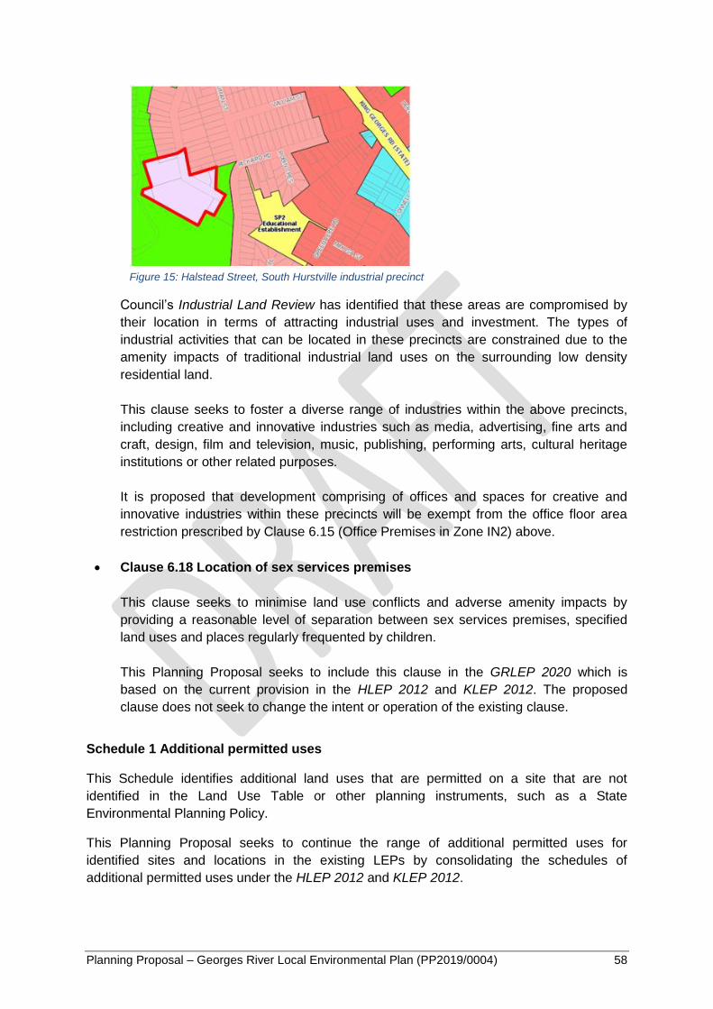
Planning Proposal – Georges River Local Environmental Plan (PP2019/0004) 58
Figure 15: Halstead Street, South Hurstville industrial precinct
Council’s Industrial Land Review has identified that these areas are compromised by
their location in terms of attracting industrial uses and investment. The types of
industrial activities that can be located in these precincts are constrained due to the
amenity impacts of traditional industrial land uses on the surrounding low density
residential land.
This clause seeks to foster a diverse range of industries within the above precincts,
including creative and innovative industries such as media, advertising, fine arts and
craft, design, film and television, music, publishing, performing arts, cultural heritage
institutions or other related purposes.
It is proposed that development comprising of offices and spaces for creative and
innovative industries within these precincts will be exempt from the office floor area
restriction prescribed by Clause 6.15 (Office Premises in Zone IN2) above.
Clause 6.18 Location of sex services premises
This clause seeks to minimise land use conflicts and adverse amenity impacts by
providing a reasonable level of separation between sex services premises, specified
land uses and places regularly frequented by children.
This Planning Proposal seeks to include this clause in the GRLEP 2020 which is
based on the current provision in the HLEP 2012 and KLEP 2012. The proposed
clause does not seek to change the intent or operation of the existing clause.
Schedule 1 Additional permitted uses
This Schedule identifies additional land uses that are permitted on a site that are not
identified in the Land Use Table or other planning instruments, such as a State
Environmental Planning Policy.
This Planning Proposal seeks to continue the range of additional permitted uses for
identified sites and locations in the existing LEPs by consolidating the schedules of
additional permitted uses under the HLEP 2012 and KLEP 2012.

Planning Proposal – Georges River Local Environmental Plan (PP2019/0004) 59
The Planning Proposal also proposes a number of key amendments to Schedule 1 as
follows:
In accordance with the Council resolution dated 8 July 2019 regarding the Planning
Proposal for the Low Rise Medium Density Housing Code, delete Items 17 and 18
(Use of certain land for multi dwelling housing) from Schedule 1 of KLEP 2012 to
prevent manor houses, multi dwelling housing (terraces), villas and townhouses from
being built through a development application;
In accordance with the recommendations of the draft Commercial Centres Strategy –
Part 1:
o Delete Item 16(ja) (Use of certain land for limited commercial and residential
purposes - 129 Laycock Road, Hurstville Grove) from Schedule 1 of KLEP
2012 and incorporate the site into the adjacent business zone; and
o Delete Item 16(la) (Use of certain land for limited commercial and residential
purposes - 29–31 Rocky Point Road, Kogarah) from Schedule 1 of KLEP
2012 and incorporate the site into the adjacent business zone;
In accordance with the legal advice received from Counsel, insert all sites in the R2
Low Density Residential zone where there is an existing place of public worship to
ensure its permissibility following the prohibition of places of public worship in the R2
Low Density Residential zone of the GRLEP 2020; and
In accordance with the LSPS vision for Jubilee Stadium to be a regionally significant
sporting and entertainment hub, insert ‘entertainment facility’ as an additional
permitted use at Jubilee Stadium due to the prohibition of entertainment facilities
across the RE1 Public Recreation zone.
Schedule 2 Exempt development
Schedule 2 allows Council to nominate additional exempt development to those specified in
SEPPs, such as the Codes SEPP. This Planning Proposal seeks to delete the existing
exempt development provisions and rely on the provisions of the Codes SEPP.
Schedule 3 Complying development
Similar to Schedule 2, Schedule 3 allows Council to nominate additional complying
development to those specified in SEPPs, such as the Codes SEPP. No complying
development is specified within the existing LEPs.
This Planning Proposal seeks to rely on the provisions of the Codes SEPP and does not
introduce any new complying development.
Schedule 4 Classification and reclassification of public land
Schedule 4 provides a location for Council to capture information on the classification and
reclassification of public land as either community or operational land in accordance with the
Local Government Act 1993. This Schedule will appear blank for the GRLEP 2020 but may

Planning Proposal – Georges River Local Environmental Plan (PP2019/0004) 60
be used during the life of the LEP should changes to public land classification be adopted by
Council.
The details of land classification and reclassifications are recorded in Council’s register of
land under section 53(2) of the Local Government Act. As no new land classifications are
proposed, Schedule 4 will not be populated.
Schedule 5 Environmental heritage
This Planning Proposal seeks to merge the Schedule 5 planning provisions under the
existing LEPs to form Schedule 5 under the GRLEP 2020.
Under the GRLEP 2020 it is proposed to delete the following 3 heritage items following
review of the current HLEP 2012 heritage items as part of the Hurstville Heritage Review:
78 Bonds Road, Peakhurst as the existing fabric is almost all new and the item
includes substantial additions.
127-137 Forest Road, Hurstville due to the adverse impact of recent redevelopment,
the significant of the item has been impacted causing loss of the physical, spatial and
aesthetic context of the original building.
237 Forest Road, Hurstville as the original building has either been demolished and
re-built or heavily altered.
Additionally, 19 heritage items are to have their description amended to reflect their
significance in relation to their built form and setting in accordance with the
recommendations of the Hurstville Heritage Review. This amendment is proposes the
removal of the façade only description of the heritage items under HLEP 2012 by amending
their descriptions to include the whole of the heritage building in GRLEP 2020.
Whilst the façade is a visually prominent feature of a heritage item, the proposed description
intends to clarify the item’s significance in a holistic manner by incorporating the fabric of the
item including its façade, built form and setting. This amendment is incorporated with the
intent of ensuring any future development is designed to sympathetically respond to the
heritage character through appropriate design solutions, adaptive re-use and interpretation.
This Planning Proposal does not seek to amend any of the heritage items currently located
within the former Kogarah LGA which was subject to a heritage review in 2012.
Schedule 6 Pond-based and tank-based aquaculture
This Schedule provides further information on aquaculture activities, including site location
and operational requirements. All items in this Schedule are compulsory in SILEP and must
be included in the GRLEP 2020.

Planning Proposal – Georges River Local Environmental Plan (PP2019/0004) 61
Dictionary
The Dictionary provides definitions for land uses and terms in the SILEP. The Dictionary
cannot be amended and must be included in the GRLEP 2020.
Maps
This Planning Proposal seeks to combine mapping from the existing LEPs as relevant to the
provisions adopted by the GRLEP 2020 into a consolidated set of maps. The proposed
GRLEP 2020 maps are provided in Appendix 7.

Planning Proposal – Georges River Local Environmental Plan (PP2019/0004) 62
10. Part 3: Justification
Section A – Need for the planning proposal
Q1. Is the planning proposal a result of an endorsed local strategic planning statement,
strategic study or report?
This Planning Proposal has been instigated as a result of the amalgamation between the
former Hurstville and Kogarah Councils on 12 May 2016 which has necessitated a
consolidated local environmental plan for the Georges River LGA.
Amendments to the EP&A Act require councils to prepare a LSPS for the LGA. The LSPS
sets out the land use vision for the LGA by 2040. This Planning Proposal outlines how
Georges River will implement the LSPS vision through a new principal LEP.
As noted above, the LSPS proposes a staged approach to preparing the principal Georges
River LEP due to the detailed investigations required to support the full suite of changes
proposed. This approach was endorsed by Council as its meeting on 23 April 2019 and 28
October 2019.
The staged approach to preparing the Georges River LEP is outlined as follows:
Stage 1 – Housing and Harmonisation (this Planning Proposal)
o Harmonise the existing LEPs
o Seek to achieve housing targets through up-zoning certain areas
Stage 2 – Housing Choice (scheduled for 2021)
o Seek to promote inclusive and affordable housing
o Investigate big house conversions and build to rent
Stage 3 – Jobs and Activation (scheduled for 2022)
o Review development standards in centres
o Infrastructure delivery mechanisms
o Hurstville City Centre and Beverly Hills Local Centre masterplanning
Stage 4 – Housing and Future Growth (scheduled for 2025 and beyond)
o Undertake a new housing strategy as required
The Georges River LSPS was placed on exhibition between 26 June 2019 and 7 August
2019. Council received 137 submissions from the community and public authorities. The key
issues identified are summarised in Section 1 above.
The LSPS has been updated in response to the submissions and was reported to Council on
28 October 2019. At this meeting, Council resolved to endorse the revised LSPS for
submission to the GSC for their approval to formally adopt the LSPS 2040 for the Georges
River LGA.

Planning Proposal – Georges River Local Environmental Plan (PP2019/0004) 63
Q2. Is the planning proposal the best means of achieving the objectives or intended
outcomes, or is there a better way?
The subject Planning Proposal is the only means of delivering a new principal Georges River
Local Environmental Plan, which is consistent with the LSPS 2040.
This Planning Proposal will provide a harmonised set of planning controls across the LGA
and will ensure residents and the development industry have access to an integrated
document that will guide the sustainable development of the LGA. A single LEP for the LGA
will provide a consistent approach to planning and development and introduce new
provisions that implement the LSPS vision, including preserving landscaped areas within
residential zones, promoting design excellence, providing housing diversity and encouraging
the provision of employment floor space.
Section B – Relationship to strategic planning framework
Q3. Will the planning proposal give effect to the objectives and actions of the applicable
regional, or district plan or strategy (including any exhibited draft plans or strategies)?
An assessment of the proposal against the objectives and actions of the Greater Sydney
Region Plan – A Metropolis of Three Cities and the South District Plan is detailed in
Appendix 2. The assessment demonstrates that this Planning Proposal either assists in
achieving the objectives and actions of the South District Plan or is consistent with the
directions of the Greater Sydney Region Plan.
Q4. Will the planning proposal give effect to a council’s endorsed local strategic planning
statement, or another endorsed local strategy or strategic plan?
As set out in Section A, this Planning Proposal seeks to implement the LSPS vision through
the Georges River Principal LEP in its various stages.
An assessment of the actions of the LSPS which this Planning Proposal seeks to achieve in
the GRLEP 2020 is detailed in Appendix 2. Longer term LSPS actions will be implemented
through the later stages of the Georges River Principal LEP.
Q5. Is the planning proposal consistent with applicable State Environmental Planning
Policies (SEPPs)?
This Planning Proposal has been considered against the relevant SEPPs and is determined
to be consistent with the relevant provisions as set out in Appendix 5.
Q6. Is the planning proposal consistent with applicable Ministerial Directions (s.9.1
directions)?
The Planning Proposal has been considered against the relevant Ministerial Directions and
is determined to be consistent as set out in Appendix 6.

Planning Proposal – Georges River Local Environmental Plan (PP2019/0004) 64
Section C – Environmental, social and economic impact
Q7. Is there any likelihood that critical habitat or threatened species, populations or
ecological communities, or their habitats, will be adversely affected as a result of the
proposal?
This Planning Proposal will not adversely affect critical habitat, threatened species,
populations or ecological communities or their habitats.
All of the land that is proposed to be rezoned under this Planning Proposal to allow
increased residential density (i.e. the Housing Investigation Areas) is currently zoned
residential and is urban land and therefore would have minimal impact on critical habitats or
threatened species. In addition, this Planning Proposal seeks to strengthen landscaping
requirements within residential and environmental zones for the purpose of promoting
enhanced biodiversity across the LGA.
Land currently zoned for environmental conservation and/or waterways is to be retained
without change and therefore the existing protection and management of this land will
continue. The proposed changes to the permissible land uses under the respective zonings
are minimal and appropriate and therefore there are no adverse impacts from this.
The Foreshore Scenic Protection Area is currently only identified within the former Hurstville
LGA as shaded blue in Figure 16.
Figure 16: Existing Hurstville Foreshore Scenic Protection Area

Planning Proposal – Georges River Local Environmental Plan (PP2019/0004) 65
This Planning Proposal seeks to extend the foreshore scenic protection area across the
LGA, to protect environmentally sensitive areas, increase the tree canopy and enhance
biodiversity within the LGA. In addition, this Planning Proposal seeks to include local
provisions for the foreshore area and coastal hazards which will ensure the protection of
ecological habitats, riparian lands and watercourses and ensure that development does not
impact on the natural foreshore processes. These new local provisions will strengthen the
environmental controls applicable to new development across the LGA and mitigate or
prevent any adverse environmental impacts of development.
Q8. Are there any other likely environmental effects as a result of the planning proposal and
how are they proposed to be managed?
This Planning Proposal primarily seeks to strengthen controls to mitigate potential
environmental effects due to development, with the introduction of several new local
provisions, as outlined below.
This Planning Proposal seeks to ensure that the landscape character within residential
suburbs is preserved which will ensure that vegetation contributes to biodiversity and tree
canopy. This Planning Proposal will achieve these objectives by introducing Clause 6.12:
“Landscaped areas in residential and environmental protection zones”. This provision will not
apply to residential flat buildings where landscaping requirements are detailed within the
Apartment Design Guide. The inclusion of this provision within the GRLEP 2020 will
strengthen and enhance the environment and assist in mitigating the impact of increased
residential density in the identified up-zoned areas.
In addition to the above, it is also proposed to introduce Clause 6.6: “Foreshore scenic
protection area”, the objective of which is to protect the natural environment, minimise
disturbance to native vegetation and consider the impact on views to/from the Georges
River. Additionally, Clause 6.4: “Stormwater management” and Clause 6.11: “Environmental
sustainability in certain business, industrial and residential zones” will be introduced to
ensure that developments responsibly manage the impacts of urban stormwater run-off and
are consistent with the principles of best practice environmentally sensitive design,
especially in industrial, business and high density residential zones.
This Planning Proposal also seeks to expand the application of the KLEP 2012 flood
planning provision to the former Hurstville LGA and introduce flood controls to sensitive land
uses when they are proposed on land affected by the PMF. Application of the provision
across the Georges River LGA will improve the management of flood planning and mitigation
across the LGA.
Q9. Has the planning proposal adequately addressed any social and economic effects?
This Planning Proposal seeks to provide greater certainty to landowners by aligning controls
across the LGA creating positive social and economic effects.
The potential loss of employment floor space through infill development has been identified
by the Commercial Centres Strategy Part 1 as a key issue for the Georges River LGA. This
Planning Proposal seeks to include a minimum non-residential floor space within mixed use
Planning Proposal – Georges River Local Environmental Plan (PP2019/0004) 66
zones to ensure the protection of employment lands and reduce the continued loss of
employment floor space through redevelopment.
This Planning Proposal seeks to increase heights within the industrial zones to promote
employment and redevelopment opportunities. The current height control of 10m is a barrier
to redevelopment as it does not enable high clearance warehouse space, provide maximum
flexibility for redevelopment nor allow developments to achieve the full FSR potential.
The Industrial Land Review identifies Kingsgrove and Peakhurst industrial areas as the two
largest industrial areas which still have undeveloped potential, both are growing and are
suitable for industrial development, thus supporting the increased height limit of 16m. The
social impact of these increased heights has been adequately addressed by applying lower
heights to the areas adjoining residential zoned land.
This Planning Proposal seeks to include two local provisions relating specifically to industrial
lands. Firstly, a provision to permit office floor space that is in addition to the office floor
space associated with the primary industrial use but limiting the size of this additional office
space so as to not compromise industrial and urban services. Inclusion of this provision will
enable the flexibility for industrial properties to include additional office floor space whilst also
ensuring there is no significant loss in land for industrial activities. Secondly, this Planning
Proposal seeks to encourage creative industries within the IN2 zones in two areas;
Penshurst Lane, Penshurst and Halstead Street, South Hurstville to broaden the range of
permitted uses whilst promoting job creation. Both local provisions will seek to enhance
economic opportunities with the IN2 zone.
Section D – State and Commonwealth interests
Q10. Is there adequate public infrastructure for the planning proposal?
This Planning Proposal provides additional housing through the up-zoning of existing low
density residential areas in highly accessible areas which are serviced by shops, schools,
open space and community facilities. The areas proposed to be up-zoned are located within
walking distance to transport infrastructure, such as train stations and frequent bus services,
encouraging the efficient use of existing public infrastructure.
To supplement the existing provision of open space, the Planning Proposal identifies the
following additional sites for open space acquisition:
26 – 30 Culwulla Street, South Hurstville;
11-21 Monaro Avenue, Kingsgrove (Peter Lowe Reserve); and
7 Hedley Street, Riverwood and 13-15 Keith Street, Peakhurst (Peakhurst Park).
Council’s Infrastructure Integration Advice Roadmap has been prepared to conduct a gap
analysis which identifies data gaps in relation to economic, social and green infrastructure
outcomes. The Roadmap will assist Council in understanding the critical infrastructure that is
required to support housing and employment growth over the short, medium and long term
in alignment with the LSPS Actions. The data gaps that have not been able to be addressed
in LSPS 2040 will be reviewed and considered as part of future policy work and/or work
programs in accordance with the commitment given at Council’s meeting on 28 October
2019.

Planning Proposal – Georges River Local Environmental Plan (PP2019/0004) 67
Council is also currently preparing a consolidated development contributions plan for the
whole Georges River LGA. The new plan will fund infrastructure required to support the
anticipated growth resulting from the GRLEP 2020, including the consideration of funding
sources for the existing and proposed land acquisitions.
Q11. What are the views of State and Commonwealth public authorities consulted in
accordance with the Gateway determination?
As this Planning Proposal has not been forwarded to the Minister for Planning and Public
Spaces for a Gateway Determination, the appropriate State and Commonwealth public
authorities have not yet been consulted.
However, State and Commonwealth public authorities will be consulted in accordance with a
Gateway Determination and will be given at least 28 days to comment on this Planning
Proposal.

Planning Proposal – Georges River Local Environmental Plan (PP2019/0004) 68
11. Part 4: Mapping
The following maps have been prepared as part of the GRLEP 2020. The proposed GRLEP
2020 maps are provided in Appendix 7.
Land Application Map
Land Zoning Map
Lot Size Map
Lot Size for Dual Occupancy Development Map
Height of Buildings Map
Floor Space Ratio Map
Land Reservation Acquisition Map
Heritage Map
Acid Sulfate Soils Map
Coastal Hazard and Risk Map
Foreshore Building Line Map
Foreshore Scenic Protection Area Map
Riparian Lands and Watercourses Map
Flood Planning Map
Probable Maximum Flood Map
Key Sites Map
Planning Proposal – Georges River Local Environmental Plan (PP2019/0004) 69
12. Part 5: Community Consultation
It is anticipated that this Planning Proposal will be exhibited for a minimum period of 28 days
in accordance with the provisions of the EP&A Act 1979 and the Environmental Planning &
Assessment Regulation 2000 and any requirements of the Gateway Determination.
In accordance with the NSW Government’s Best Practice Guideline for LEPs and Council
Land (dated January 1997), this Planning Proposal will be exhibited with a register of all
council-owned land which outlines the following:
The nature of Council’s interest in the land;
When Council first acquired an interest in the land;
Why Council acquired an interest in the land (e.g. for an extension to the adjoining
park);
How Council acquired its interest in the land (e.g. the land was purchased); and
For land previously owned or controlled by Council, whether any aspect of the LEP
formed part of the agreement to dispose of the land, and the terms of any such
agreement.
The public exhibition of this Planning Proposal will also be supported by a number of key
Council strategies and studies, including but not limited to:
Local Strategic Planning Statement 2040
Local Housing Strategy (including the Traffic Study)
Inclusive Housing Strategy
Commercial Centres Strategy – Part 1
Industrial Lands Review
Foreshore Study
Infrastructure Integration Advice Roadmap
Hurstville Heritage Review
Exhibition material, including plain English explanatory information, fact sheets, description
of the objectives and intended outcomes, copy of the Planning Proposal and relevant maps
will be available for viewing during the exhibition period on Council’s website and hard
copies available at Council offices and libraries. Targeted consultation through mechanisms,
including but not limited to targeted letters and drop-in information sessions, are proposed to
be conducted.
Notification of the public exhibition will be through:
Newspaper advertisement in The Leader;
Exhibition notice on Council’s website;
Community engagement project on Council’s YourSay website;
Notices in Council offices and libraries;
Letters to all landowners and residents in the LGA – this will include letters to
landowners of properties affected by a proposed change in the planning controls; and
Letters to State and Commonwealth Government agencies identified in the Gateway
Determination.
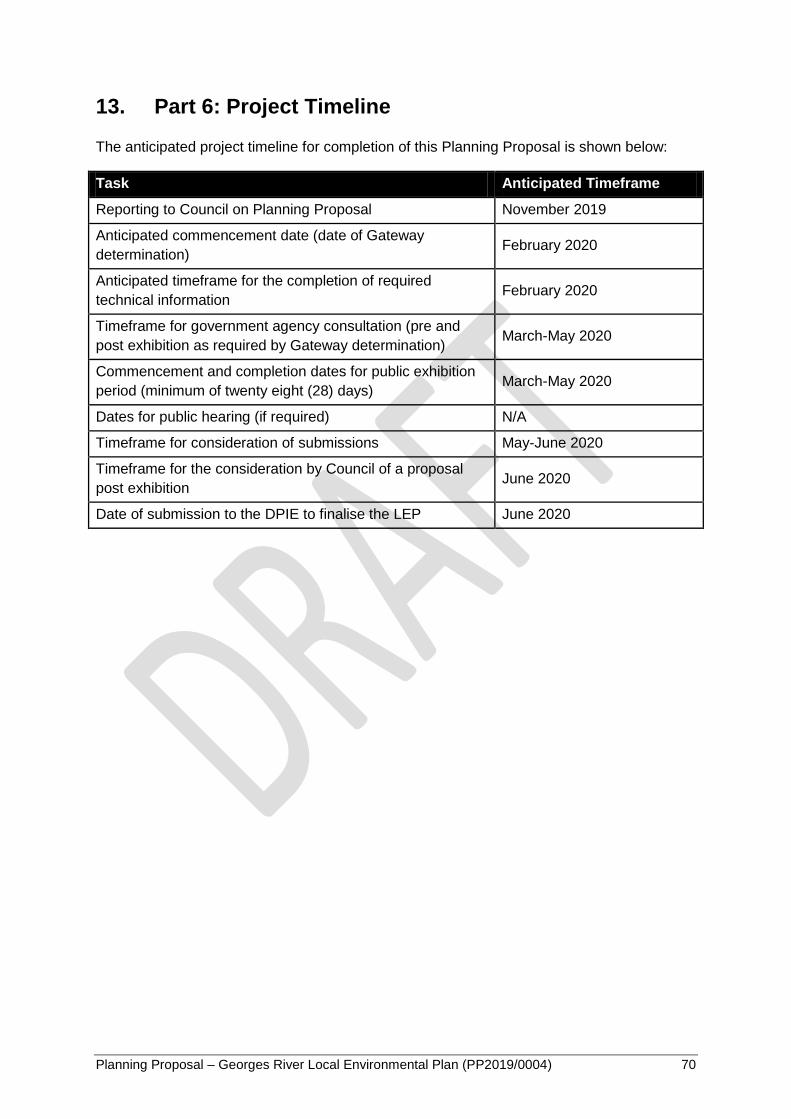
Planning Proposal – Georges River Local Environmental Plan (PP2019/0004) 70
13. Part 6: Project Timeline
The anticipated project timeline for completion of this Planning Proposal is shown below:
Task Anticipated Timeframe
Reporting to Council on Planning Proposal November 2019
Anticipated commencement date (date of Gateway
determination) February 2020
Anticipated timeframe for the completion of required
technical information February 2020
Timeframe for government agency consultation (pre and
post exhibition as required by Gateway determination) March-May 2020
Commencement and completion dates for public exhibition
period (minimum of twenty eight (28) days) March-May 2020
Dates for public hearing (if required) N/A
Timeframe for consideration of submissions May-June 2020
Timeframe for the consideration by Council of a proposal
post exhibition June 2020
Date of submission to the DPIE to finalise the LEP June 2020

Planning Proposal – Georges River Local Environmental Plan (PP2019/0004) 71
14. Conclusion
The purpose of this Planning Proposal is to prepare a consolidated principal Georges River
LEP which implements the first stage of the staged LEP approach.
With a focus on housing and harmonisation, this LEP will ensure that a single consistent
approach is applied to planning and development across the LGA.
This Planning Proposal:
Gives effect to the South District Plan by addressing its Planning Priorities and
Actions;
Implements the LSPS 2040 vision for the LGA addressing its Planning Priorities
and Actions;
Meets the South District Plan housing targets;
Identifies additional housing opportunities through the harmonisation of existing
LEPs;
Retains and manages industrial and urban services land;
Provides a regulatory environment that enables economic opportunities;
Protects future transport and infrastructure corridors;
Facilitates opportunities for creative and artistic industries; and
Identifies, conserves and enhances environmental heritage.
Planning Proposal – Georges River Local Environmental Plan (PP2019/0004) 72
15. Appendices
Appendix 1 Draft instrument - Georges River Local Environmental Plan 2020
Appendix 2 Consistency with the Greater Sydney Region Plan, South District Plan and Council’s Local Strategic Planning Statement 2040
Appendix 3 Development standards justification
Appendix 4 Additional local provisions justification
Appendix 5 Consistency with State Environmental Planning Policies (SEPPs)
Appendix 6 Consistency with S9.1 Ministerial Directions
Appendix 7 GRLEP 2020 Mapping