georges river estuary czmp river... · georges river estuary coastal zone management plan. the...
TRANSCRIPT
NEW CITY PLAN
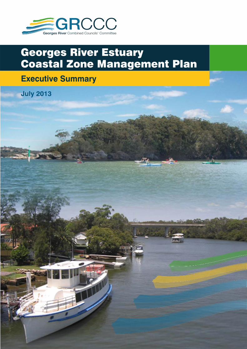
Executive Summary
July 2013
Georges River EstuaryCoastal Zone Management Plan
The Georges River Coastal Zone Management Plan (CZMP) has been prepared by the Georges River Combined Councils Committee (GRCCC) in association with the NSW Department of Premier and Cabinet’s Office of Environment and Heritage (OEH) and in consultation with other stakeholder agencies and the community. The CZMP aims to preserve and enhance the environmental values of the estuary amid the burgeoning urban development across the catchment, which presently accommodates more than 1.2 million people.
The CZMP has been developed collaboratively by the seven local councils along the Georges River Estuary, in partnership with the community and key agencies. These councils include (from downstream to upstream) Sutherland Shire, Rockdale City, Kogarah City, Hurstville City, Bankstown City, Fairfield City and Liverpool City Councils. It is expected that other authorities, including DPI-Fisheries, National Parks, Sydney Water and the Hawkesbury Nepean CMA will also assist with the implementation of a number of strategies in the Plan. It is also expected that the community and broader stakeholders will take a keen interest in the document, along with its preceding Data Compilation and Estuary Processes Study (SMEC, 2010).
This plan is the result of partnership in action and we thank all participants for their input and collaborative effort. The hard work of the GRCCC’s Estuary Management Committee has seen this CZMP completed within a relatively short timeframe for a plan of this scope and magnitude.
I encourage the councils of the Georges River Estuary, as well as the councils of the broader Georges River catchment, to implement as many of the Management Options within the CZMP as possible in order that we achieve the agreed aims and objectives of the plan, and secure the long term environmental health of the Georges River Estuary.
Cr Naji Peter NajjarGRCCC Chairperson
The Georges River Estuary Coastal Zone Management Plan (CZMP) is a strategic document aimed at providing clear direction and guidance on future landuse and environmental planning as well as on-the-ground management actions across the estuary, and its broader catchment. The primary goal of the Georges River Estuary CZMP has been defined as:
“to conserve and improve the existing natural environment of the Georges River Estuary, and to improve the water quality of the estuary through targeted pollution reduction” This Coastal Zone Management Plan has been developed under the NSW Government’s Estuary Management Program in accordance with the specifications of Part 4a of the Coastal Protection Act 1979 which involves following the new Guidelines for Preparation of Coastal Zone Management Plans (DECCW, 2010). It complies with the requirements of the NSW Coastal Policy 1997, and the former Sydney Metropolitan Catchment Action Plan (Management Target CTECM1).
The CZMP is complementary to planning instruments and environmental management strategies and initiatives being used and implemented by Councils and other stakeholders. This includes new LEPs and DCPs for the Councils, as well as Catchment-based strategies, such as the Botany Bay WQIP. Once gazetted, this Plan is to be consulted during all future reviews of Environmental Planning Instruments and place-based Plans across the catchment area. It is also to be taken into account in determining development applications under Section 79C of the Environmental Planning and Assessment Act 1979 that may potentially have an impact on the estuary or its surrounding foreshore environments.
BACKGROUNDAND CONTEXT
Foreward
2
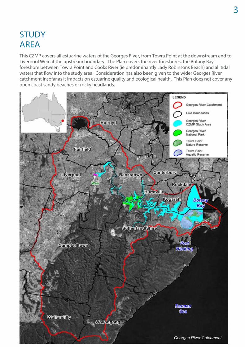
This CZMP covers all estuarine waters of the Georges River, from Towra Point at the downstream end to Liverpool Weir at the upstream boundary. The Plan covers the river foreshores, the Botany Bay foreshore between Towra Point and Cooks River (ie predominantly Lady Robinsons Beach) and all tidal waters that flow into the study area. Consideration has also been given to the wider Georges River catchment insofar as it impacts on estuarine quality and ecological health. This Plan does not cover any open coast sandy beaches or rocky headlands.
STUDYAREA
3
Georges River Catchment
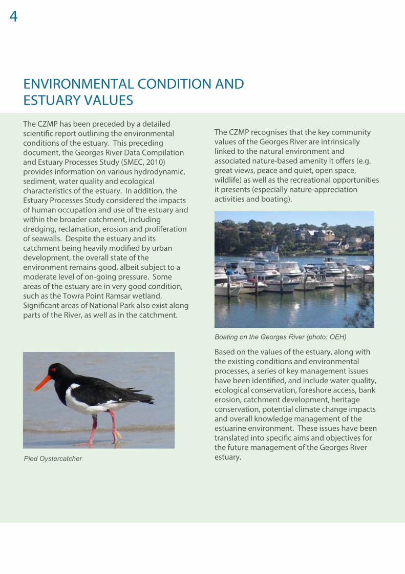
Pied Oystercatcher
Boating on the Georges River (photo: OEH)
The CZMP has been preceded by a detailed scientific report outlining the environmental conditions of the estuary. This preceding document, the Georges River Data Compilation and Estuary Processes Study (SMEC, 2010) provides information on various hydrodynamic, sediment, water quality and ecological characteristics of the estuary. In addition, the Estuary Processes Study considered the impacts of human occupation and use of the estuary and within the broader catchment, including dredging, reclamation, erosion and proliferation of seawalls. Despite the estuary and its catchment being heavily modified by urban development, the overall state of the environment remains good, albeit subject to a moderate level of on-going pressure. Some areas of the estuary are in very good condition, such as the Towra Point Ramsar wetland. Significant areas of National Park also exist along parts of the River, as well as in the catchment.
The CZMP recognises that the key community values of the Georges River are intrinsically linked to the natural environment and associated nature-based amenity it offers (e.g. great views, peace and quiet, open space, wildlife) as well as the recreational opportunities it presents (especially nature-appreciation activities and boating).
Based on the values of the estuary, along with the existing conditions and environmental processes, a series of key management issues have been identified, and include water quality, ecological conservation, foreshore access, bank erosion, catchment development, heritage conservation, potential climate change impacts and overall knowledge management of the estuarine environment. These issues have been translated into specific aims and objectives for the future management of the Georges River estuary.
ENVIRONMENTAL CONDITION AND ESTUARY VALUES
4
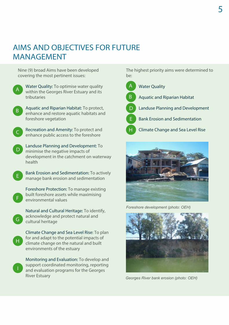
AIMS AND OBJECTIVES FOR FUTURE MANAGEMENT
The highest priority aims were determined to be:
Nine (9) broad Aims have been developed covering the most pertinent issues:
Water Quality: To optimise water quality within the Georges River Estuary and its tributaries
Aquatic and Riparian Habitat: To protect, enhance and restore aquatic habitats and foreshore vegetation
Recreation and Amenity: To protect and enhance public access to the foreshore Landuse Planning and Development: To minimise the negative impacts of development in the catchment on waterway health
Bank Erosion and Sedimentation: To actively manage bank erosion and sedimentation
Foreshore Protection: To manage existing built foreshore assets while maximising environmental values
Natural and Cultural Heritage: To identify, acknowledge and protect natural and cultural heritage
Climate Change and Sea Level Rise: To plan for and adapt to the potential impacts of climate change on the natural and built environments of the estuary
Monitoring and Evaluation: To develop and support coordinated monitoring, reporting and evaluation programs for the Georges River Estuary
5
Foreshore development (photo: OEH)
Georges River bank erosion (photo: OEH)
A
B
C
D
E
F
G
H
I
Water Quality
Aquatic and Riparian Habitat
Landuse Planning and Development
Bank Erosion and Sedimentation
Climate Change and Sea Level Rise
A
B
D
E
H

Reduce the volume & pollutant load of stormwater runoff through the catchment
Improve the performance of sewer overflows
All greenfield and redevelopments should have a minimal negative impact on flow and water quality, meeting targets for water quality proposed in the Botany Bay WQIP
Strive to protect undeveloped areas of the broader catchment that act as a buffer to water quality
Minimise the negative impacts of new and existing commercial operations in the catchment and estuary on flow and water quality
A total of twenty seven (27) Management Objectives have been defined, which relate to each of the nine broad aims. The Management Objectives were prioritised based on the importance of each Aim and the degree to which each Objective addresses the Aims.
The top 10 ranked Management Objectives (in priority order) are:
Reduce the extent and severity of bank and foreshore erosion while minimising the impacts on estuary health
Minimise build-up of gross pollutants and illegal dumping of waste into and along the estuary foreshore and waterways
Reduce the causes and impacts of sedimentation in the estuary
Protect and improve the extent and condition of estuarine and riparian vegetation
Minimise the cause and spread of invasive species in aquatic and terrestrial habitats
6
AIMS AND OBJECTIVES FOR FUTURE MANAGEMENT
A1
A3
A2
A5
A6
E1
A4
B2
E2
B3
Saltmarsh at Bankstown (photo: OEH)
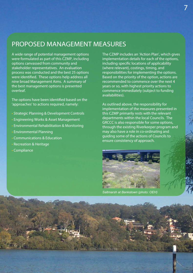
A wide range of potential management options were formulated as part of this CZMP, including options canvassed from community and stakeholder representatives. An evaluation process was conducted and the best 25 options were identified. These options help address all nine broad Management Aims. A summary of the best management options is presented overleaf.
The options have been identified based on the ‘approaches’ to actions required, namely:
Strategic Planning & Development Controls
Engineering Works & Asset Management
Environmental Rehabilitation & Monitoring
Environmental Planning
Communications & Education
Recreation & Heritage
Compliance
The CZMP includes an ‘Action Plan’, which gives implementation details for each of the options, including specific locations of applicability (where relevant), costings, timing, and responsibilities for implementing the options. Based on the priority of the option, actions are recommended to commence over the next 4 years or so, with highest priority actions to commence immediately (subject to funding availabilities).
As outlined above, the responsibility for implementation of the measures presented in this CZMP primarily rests with the relevant departments within the local Councils. The GRCCC is also responsible for some options, through the existing Riverkeeper program and may also have a role in co-ordinating and guiding some of the actions of Councils to ensure consistency of approach.
7
PROPOSED MANAGEMENT MEASURES
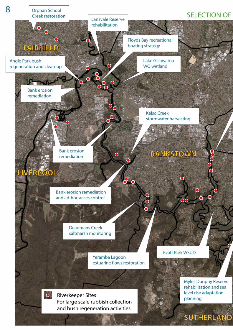
FAIRFIELD
BANKSTOWN
LIVERPOOL
SUTHERLAND
Riverkeeper SitesFor large scale rubbish collectionand bush regeneration activities
8
Myles Dunphy Reserverehabilitation and sealevel rise adaptationplanning
Evatt Park WSUD Yeramba Lagoonestuarine flows restoration
Deadmans Creeksaltmarsh monitoring
Bank erosion remediationand ad-hoc acces control
Bank erosionremediation
Bank erosionremediation
Angle Park bushregeneration and clean-up
Orphan SchoolCreek restoration
Lansvale Reserverehabilitation
Floyds Bay recreationalboating strategy
Lake GillawarnaWQ wetland
SELECTION OF
Kelso Creekstormwater harvesting
99
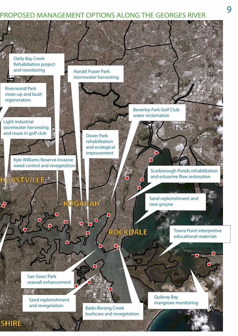
SHIRE
Dover Parkrehabilitationand ecologicalimprovement
Beverley Park Golf Club water reclamation
Scarborough Ponds rehabilitationand estuarine flow restoration
Sand replenishment andnew groyne
Towra Point interpretiveeducational materials
Quibray Baymangrove monitoring
Bado-Berong Creekbushcare and revegetation
Sand replenishmentand revegetation
San Souci Parkseawall enhancement
Light industrialstormwater harvestingand reuse in golf club
Oatly Bay CreekRehabiliation projectand monitoring
PROPOSED MANAGEMENT OPTIONS ALONG THE GEORGES RIVER
Harold Fraser Parkstormwater harvesting
Kyle Williams Reserve invasiveweed control and revegetation
KOGARAH
ROCKDALE
Riverwood Parkclean-up and bushregeneration
HURSTVILLE
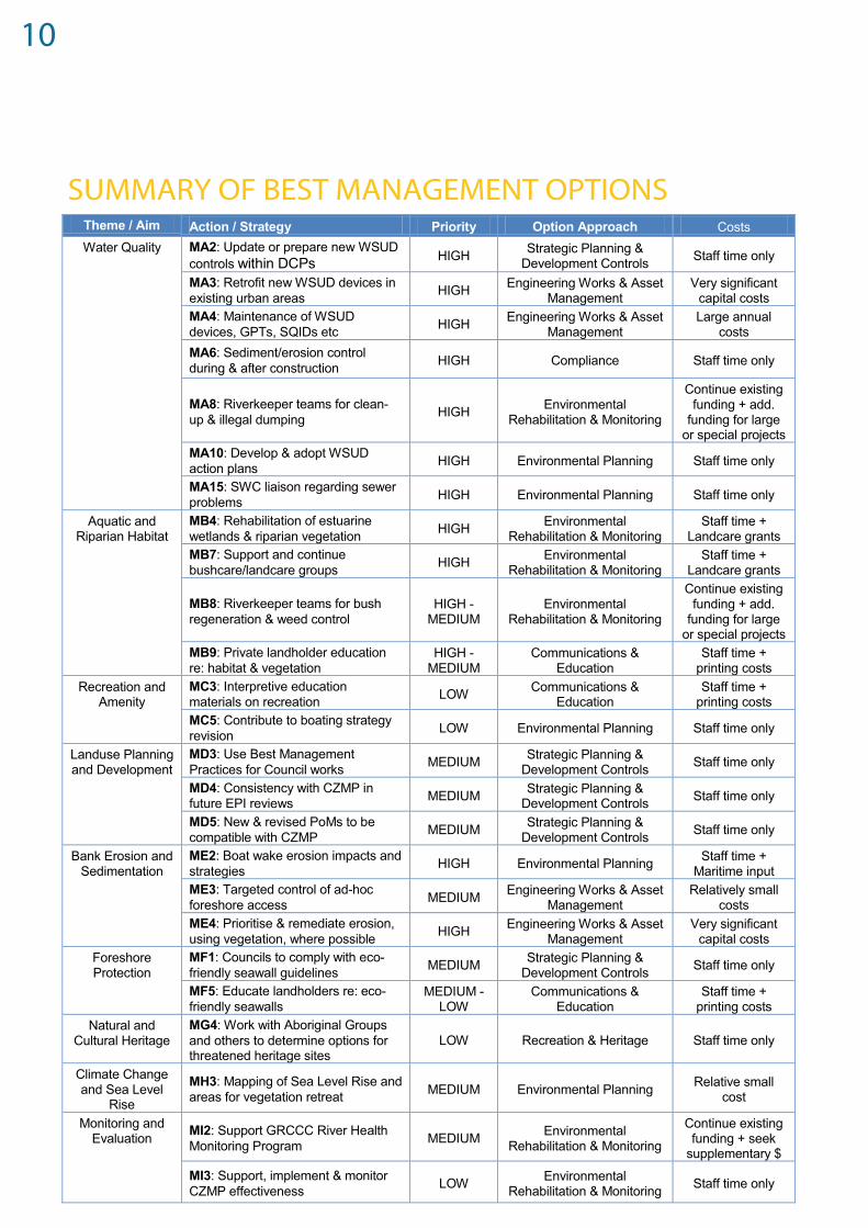
Theme / Aim Action / Strategy Priority Option Approach Costs Water Quality MA2: Update or prepare new WSUD
controls within DCPs HIGH Strategic Planning & Development Controls Staff time only
MA3: Retrofit new WSUD devices in existing urban areas HIGH Engineering Works & Asset
Management Very significant
capital costs MA4: Maintenance of WSUD devices, GPTs, SQIDs etc HIGH Engineering Works & Asset
Management Large annual
costs MA6: Sediment/erosion control during & after construction HIGH Compliance Staff time only
MA8: Riverkeeper teams for clean-up & illegal dumping HIGH Environmental
Rehabilitation & Monitoring
Continue existing funding + add.
funding for large or special projects
MA10: Develop & adopt WSUD action plans HIGH Environmental Planning Staff time only
MA15: SWC liaison regarding sewer problems HIGH Environmental Planning Staff time only
Aquatic and Riparian Habitat
MB4: Rehabilitation of estuarine wetlands & riparian vegetation HIGH Environmental
Rehabilitation & Monitoring Staff time +
Landcare grants MB7: Support and continue bushcare/landcare groups HIGH Environmental
Rehabilitation & Monitoring Staff time +
Landcare grants
MB8: Riverkeeper teams for bush regeneration & weed control
HIGH - MEDIUM
Environmental Rehabilitation & Monitoring
Continue existing funding + add.
funding for large or special projects
MB9: Private landholder education re: habitat & vegetation
HIGH - MEDIUM
Communications & Education
Staff time + printing costs
Recreation and Amenity
MC3: Interpretive education materials on recreation LOW Communications &
Education Staff time +
printing costs MC5: Contribute to boating strategy revision LOW Environmental Planning Staff time only
Landuse Planning and Development
MD3: Use Best Management Practices for Council works MEDIUM Strategic Planning &
Development Controls Staff time only
MD4: Consistency with CZMP in future EPI reviews MEDIUM Strategic Planning &
Development Controls Staff time only
MD5: New & revised PoMs to be compatible with CZMP MEDIUM Strategic Planning &
Development Controls Staff time only
Bank Erosion and Sedimentation
ME2: Boat wake erosion impacts and strategies HIGH Environmental Planning Staff time +
Maritime input ME3: Targeted control of ad-hoc foreshore access MEDIUM Engineering Works & Asset
Management Relatively small
costs ME4: Prioritise & remediate erosion, using vegetation, where possible HIGH Engineering Works & Asset
Management Very significant
capital costs Foreshore Protection
MF1: Councils to comply with eco-friendly seawall guidelines MEDIUM Strategic Planning &
Development Controls Staff time only
MF5: Educate landholders re: eco-friendly seawalls
MEDIUM - LOW
Communications & Education
Staff time + printing costs
Natural and Cultural Heritage
MG4: Work with Aboriginal Groups and others to determine options for threatened heritage sites
LOW Recreation & Heritage Staff time only
Climate Change and Sea Level
Rise
MH3: Mapping of Sea Level Rise and areas for vegetation retreat MEDIUM Environmental Planning Relative small
cost
Monitoring and Evaluation MI2: Support GRCCC River Health
Monitoring Program MEDIUM Environmental Rehabilitation & Monitoring
Continue existing funding + seek
supplementary $
MI3: Support, implement & monitor CZMP effectiveness LOW Environmental
Rehabilitation & Monitoring Staff time only
SUMMARY OF BEST MANAGEMENT OPTIONS
10
The allocation of funding and resources for individual projects would be based on funding availability and approval being given by the relevant local council. Councils are able to apply to the NSW Government for funding on a dollar for dollar basis under the Estuary Management Program to fund actions within the CZMP. This Plan can be used as a lever for obtaining environmental funds through Federal and/or other State Government funding programs.
FUNDING FOR IMPLEMENTATION
Eco-friendly seawall, Kogarah (photo: OEH)
The development of the Plan has been underpinned by extensive consultation and review by relevant Councils, the community, other key stakeholders and government agencies, as facilitated through the GRCCC’s Georges River Estuary Management Committee. The community also had the opportunity to review the Plan during a public exhibition period.
With final endorsement by Councils, the Plan will be given to the Minister for the Environment for certification. Once certified, Councils will adopt the Plan and will publish it in the Government Gazette.
The future success of the Georges River Estuary CZMP is to be gauged by how well the overall Aims of the Plan have been met. Given that the Aims are broad and likely to be measurable over long timescales only, a series of Performance Measures have been incorporated into the Action Plan for each BMO to identify progress and short term successes in Plan implementation.
This Plan has an indicative 5-10 year timeframe. Progress with implementation should be formally reviewed annually. Contingency measures should be activated if progress is slow. A complete review and amendment of the Plan should occur after a period of 5-10 years, and should redress outstanding issues, new environmental management practices, new scientific data, and changed governance and administrative arrangements.
CZMPREVIEW
11
This document along with the Georges River Estuary CZMP has been produced by BMT WBM with funding from the local councils matched by the NSW Government through its Estuary Management Program, administered by the Office of Environment and Heritage. This document does not necessarily represent the opinions of the NSW Government or the Office of Environment and Heritage.
Georges River (photo: OEH)