innovative traffic management strategies during...
TRANSCRIPT
Innovative Traffic Management Strategies during Bridge Replacement: Overcoming
Constraints and Challenges
Manoj Dilwaria, B. Eng., M. Pl. (Transp.), MCIP, RPP, AVS
Associate Director, Transportation Systems and Planning, Niagara Region
Nick Palomba, P.Eng.
Director of Transportation Services, Niagara Region
Paper prepared for presentation at the
Road and Highway Construction - Getting You There Safely Session
of the 2015 Conference of the
Transportation Association of Canada
Charlottetown, PEI
i | P a g e
Abstract
A 370m long bridge structure spanning a major provincial highway, a creek and its
associated valley lands needed to be replaced. This 100 year old high-level bridge,
a key link in the city’s transportation network, connects the city centre with the
adjacent residential areas. Considering the critical location of this bridge, traffic
and pedestrians flow including access for emergency services needed to be safely
maintained at all times, even during its replacement. Additionally, the complex
environment and area constraints necessitated the replacement of the bridge at its
current location, which posed numerous challenges pertaining to constructability
and traffic management during construction. A range of construction sequencing
needed to be developed that were efficient and cost effective but allowed for traffic
staging.
An assessment of existing tools highlighted deficiencies in the traditional approach
and as such an innovative traffic management strategy was required. This
paper/presentation focuses on the strategy that was developed using an “out of the
box” approach based on the philosophy of “avoid-minimize-mitigate”. As a first
step, constructability reviews were undertaken in cooperation with traffic
professionals to identify opportunities which would avoid impacts where possible.
This included the evaluation of various staging scenarios and construction
sequencing strategies. In attempts to minimize traffic disruption, a suite of
permissible work zone traffic configurations ranging from multi-day long term lane
closures to multi-day full highway closures and a variety of local road closures were
developed. Also, an extensive communication plan was prepared in order to
minimize and mitigate traffic congestion. The plan included strategies to reduce
clutter/traffic congestion, defined detour routes, leverage dynamic ITS messaging,
utilize media (press releases, live radio interviews, website posting, etc.). “What if”
scenarios were also developed around constraints and unknowns. A contingency
plan was developed for safe movement of people and vehicles including emergency
services. An incident management plan was prepared to mitigate and respond to
impacts in case of any unforeseen incidents.

ii | P a g e
This traffic management strategy is a “living” plan allowing for lesson learned
during the previous road and highway closures, to be leveraged to refine the
strategy prior to implementation of future closures.
1 | P a g e
Background
This paper presents a case study for the replacement of a high level, long span 100-year old bridge structure, ‘Burgoyne Bridge’ where the Region, along with their
consultant, Parsons (formerly Delcan) has successfully designed a bridge at its current location despite numerous issues and challenges related to design, property
acquisition, construction staging and overall cost. Considering the critical location of this bridge in the overall roadway network, traffic and pedestrians flow including access for emergency services needed to be safely maintained at all times, even
during its replacement. Additionally, the complex environment and area constraints necessitated the replacement of the bridge at its current location, which posed
numerous challenges pertaining to constructability and traffic management during construction. A range of construction sequencing needed to be developed that were efficient and cost effective but allowed for traffic staging.
The need for replacement of this structure stemmed from the finding of a 2010 structural assessment of the bridge. This study recommended to the Region that the structure was approaching the end of its useable life, with only 5 to 7 years
remaining and load restriction along with repairs to some of the critical structural elements needed to be undertaken in the interim. These works were implemented
shortly after the recommendations were made. Based on the findings of this report the Region initiated an environmental assessment (EA) study to assess the best course of action. The EA study addressed the following:
Rehabilitation vs. replacement of existing structure;
How to address complete streets concepts/multi-modal accommodation? Constructability including construction sequencing and traffic
management during construction; Sensitivity toward natural, socio-economic and heritage/cultural
environment; Corridor/bridge aesthetic; and Utility accommodation across the valley.
Environs
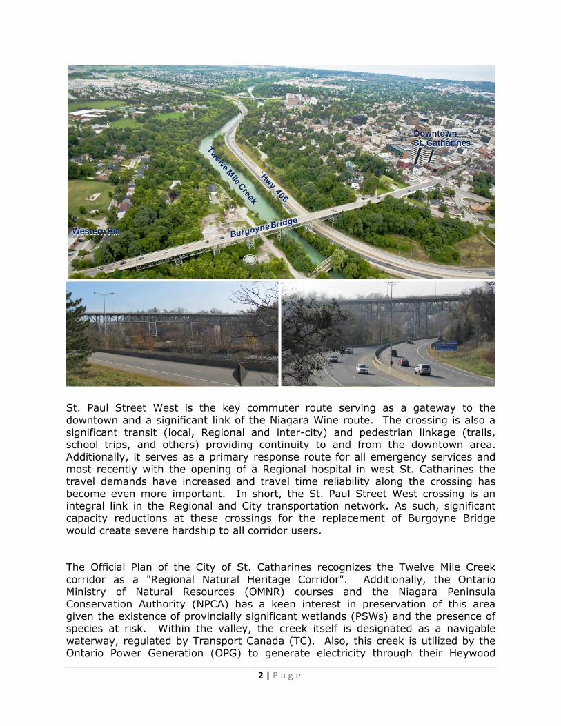
The existing Burgoyne Bridge is a steel truss structure built in 1915 spanning the Twelve Mile Creek and Highway 406 at high level (about 26m). It is 370m long and it includes multiple steel truss spans supported on steel truss towers together with
steel girder spans flanking the main structure. The bridge includes 2 travel lanes with sidewalks on both sides and carries Regional Road 81 (St. Paul Street West)
over the valley in the City of St. Catharines.
2 | P a g e
St. Paul Street West is the key commuter route serving as a gateway to the downtown and a significant link of the Niagara Wine route. The crossing is also a
significant transit (local, Regional and inter-city) and pedestrian linkage (trails, school trips, and others) providing continuity to and from the downtown area.
Additionally, it serves as a primary response route for all emergency services and most recently with the opening of a Regional hospital in west St. Catharines the travel demands have increased and travel time reliability along the crossing has
become even more important. In short, the St. Paul Street West crossing is an integral link in the Regional and City transportation network. As such, significant
capacity reductions at these crossings for the replacement of Burgoyne Bridge would create severe hardship to all corridor users.
The Official Plan of the City of St. Catharines recognizes the Twelve Mile Creek
corridor as a "Regional Natural Heritage Corridor". Additionally, the Ontario Ministry of Natural Resources (OMNR) courses and the Niagara Peninsula Conservation Authority (NPCA) has a keen interest in preservation of this area
given the existence of provincially significant wetlands (PSWs) and the presence of species at risk. Within the valley, the creek itself is designated as a navigable
waterway, regulated by Transport Canada (TC). Also, this creek is utilized by the Ontario Power Generation (OPG) to generate electricity through their Heywood
3 | P a g e
Generating Station and as such they control and adjust the water flow through the project study area. There are many agencies ranging from municipal to federal
that have jurisdictional interests in what is planned in the valley and the potential impacts of these plans.
This natural feature also contains a recreational trail and a provincial transportation
corridor within the valley area. The Merritt Trail is an 11 km pathway for both pedestrians and cyclists which crosses under the Burgoyne Bridge and connects to
the St. Paul Street West corridor on the north side of the structure. The provincial highway (Highway 406) was introduced by the Ministry of Transportation (MTO) in mid-1980s to connect the southern Niagara municipalities to downtown St.
Catharines and to the Queen Elizabeth Way (QEW). The highway corridor for the most part followed the natural topography creating a curvilinear corridor with
several non-typical interchanges with the Regional Road system. Unfortunately, the valley and the highway corridor create a significant barrier to mobility within the City of St. Catharines. These features bisect the city creating an east and a
west segment. As with all natural barriers there are limited crossing opportunities within the transportation system. Within the downtown area there are only two
bridge crossings of which Burgoyne Bridge is one.
The EA Process and Recommended Solution
This project was completed under the EA Act in accordance with the Municipal Class Environmental Assessment, October 2000, as amended in 2007 and classified as a
Schedule “C” Study, which have the potential for significant environmental affects and must proceed under the full planning and documentation procedures specified
under the Class EA document. The key objectives of this EA study were to achieve the following:
Accommodation of all modes – “Complete Streets” Bridge Structure – “Made in Niagara Solution”
Bridge Approaches – “Realign to improve roadway geometrics” User Safety – Overall bridge and approach design to improve user safety Aesthetics – Need for an aesthetically pleasing bridge
Traffic Impacts – Need to maintain traffic flow during construction
There are two main components of an EA process: Consultation and Technical Analyses. For a successful outcome of any EA study these two processes go hand
in hand in developing a preferred solution.

4 | P a g e
Consultation
Extensive consultation was undertaken throughout the study with various
stakeholder groups, agencies and the members of the public. Three public information centres were conducted where project information was presented to the public and their input was obtained. Additionally, three meetings with each
identified stakeholder group (BIA representatives, Heritage groups, City and Regional cycling groups, etc.) and technical agencies (MTO, NPCA, EMS, St.
Catharines Fire, etc.) were held. The groups/agencies were used as a sounding board prior to going to the public due to their extensive knowledge of the area. A number of one-on-one meetings with potentially affected individuals, property
owners, business owners, emergency services personnel, heritage groups and other concerned area residents were also conducted. The purpose of these meetings
were two fold, one to obtain input from stakeholder groups, technical agencies and the members of the public and the other to present the study findings as the study progressed. Various comments received during or after these meeting were utilized
in developing a preferred solution. The consultation not only assisted the project team in understanding their viewpoint, but also helped in developing a vision for
the area and ultimately achieving that vision by building consensus.
It became apparent mid-way through the study that non-traditional/innovative traffic staging within the Highway 406 corridor may be required given the numerous
constraints within the study area. As such, a special committee including the Region, the consultant and the MTO was structured to discuss the bridge
implementation and associated traffic control strategies.
Technical Studies
Considering the number of constraints within the study area and in order to evaluate the various alternative solutions, a number of technical studies were
undertaken by the project team members. These studies assisted in analysing and assessing the impacts to the environment as defined in the EA Act (i.e. natural,
socio-economic, technical and cost). This assessment was carried forward into the alternative evaluation and utilized in the selection of the preferred solution. The various technical studies undertaken included the assessment of the following:
Bridge
Transportation Demand Geotechnical Cultural Heritage
Archaeological Noise
Natural Environment
Preliminary Traffic Management Preliminary Construction
Staging
Preliminary Communication Strategies

5 | P a g e
Recommended Solution
Based on the technical studies and the extensive consultation that was undertaken,
a comprehensive evaluation of alternative solutions was completed. It was determined that the bridge needed to be replaced rather than rehabilitated. The key reasons for not rehabilitating were:
Extensive cost of rehabilitation (equivalent to the cost of replacement)
Limited useful life Inability to implement complete streets concept on bridge structure and its
approaches
Inability to maintain traffic flow (all modes) during construction
Bridge Type
As identified earlier, the existing bridge is a key link in the City’s transportation
network and should remain open even during construction of the new structure. Constructing a new bridge on the existing alignment without removing the existing
bridge certainly posed a challenge and required a non-traditional innovative solution. Adding to this challenge was the requirement of the MTO to protect for a future widening of Highway 406 by one lane in each direction. This requirement
eliminated the possibility of maintaining a bridge pier in the lands between Twelve Mile Creek and the existing highway corridor. This constraint resulted in the
requirement of the new bridge to span both the highway corridor and the creek, further complicating the bridge replacement strategy.
In selecting an appropriate bridge type, consideration was given to:
Bridge engineering/architecture Complete Streets
Stakeholder and Public Input Technical Agency Reviews
Environmental considerations History and Heritage
Budget Constructability
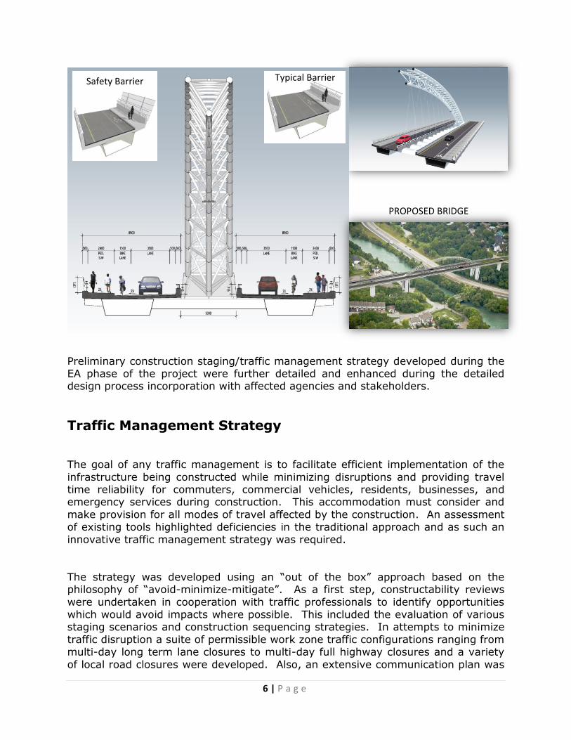
The unique design for the new Burgoyne Bridge was envisioned to celebrate the
past and to serve the future, while ensuring the least disturbance to residents and the social, natural and cultural environments. The final bridge design was a multi-
span structural steel box girder bridge with a long span steel arch that includes elements of old cable-stayed swing bridge which once crossed the creek at this location. The arch supported clear span of the highway and creek both served to
address the Highway 406 future widening requirement as well as the heritage/aesthetic requirements of the various stakeholders.
6 | P a g e
Preliminary construction staging/traffic management strategy developed during the EA phase of the project were further detailed and enhanced during the detailed design process incorporation with affected agencies and stakeholders.
Traffic Management Strategy
The goal of any traffic management is to facilitate efficient implementation of the
infrastructure being constructed while minimizing disruptions and providing travel time reliability for commuters, commercial vehicles, residents, businesses, and emergency services during construction. This accommodation must consider and
make provision for all modes of travel affected by the construction. An assessment of existing tools highlighted deficiencies in the traditional approach and as such an
innovative traffic management strategy was required.
The strategy was developed using an “out of the box” approach based on the philosophy of “avoid-minimize-mitigate”. As a first step, constructability reviews
were undertaken in cooperation with traffic professionals to identify opportunities which would avoid impacts where possible. This included the evaluation of various staging scenarios and construction sequencing strategies. In attempts to minimize
traffic disruption a suite of permissible work zone traffic configurations ranging from multi-day long term lane closures to multi-day full highway closures and a variety
of local road closures were developed. Also, an extensive communication plan was
Safety Barrier Typical Barrier
PROPOSED BRIDGE

7 | P a g e
prepared in order to minimize and mitigate traffic congestion. The plan included strategies to reduce clutter/traffic congestion, defined detour routes, leverage
dynamic ITS messaging, utilize media (press releases, live radio interviews, website posting, etc.). “What if” scenarios were also developed around constraints and
unknowns. A contingency plan was developed for safe movement of people and vehicles including emergency services. An incident management plan was prepared to mitigate and respond to impacts in case of any unforeseen incidents.
This traffic management strategy is a “living” plan allowing for lesson learned during the previous road and highway closures, to be leveraged to refine the strategy prior to implementation of future closures.
Constructability – “Avoid”
A range of construction sequencing needed to be developed that were efficient and cost effective but allowed for traffic staging. Constructability reviews were
undertaken to avoid impacts where possible.
Initially, a concept was developed to construct the new bridge west of the existing bridge (along with temporary approaches) while maintaining traffic on the existing
bridge. Once the new bridge was constructed, the traffic would be diverted onto the new bridge to allow for the removal of the existing bridge and the construction
of new support columns. When completed, the new bridge could be slid onto the new support columns at the existing alignment. The project team members have in the past successfully implemented this construction staging. Geotechnical
assessment results obtained later in the study identified that the soil conditions, including the presence of artesian water, would make this construction
methodology non feasible.
Subsequently, a new non-traditional construction staging was developed that would allow for maintaining traffic during the construction of the new bridge structure.
This included constructing the bridge in stages while keeping the existing bridge open to the various modes throughout the construction period. This would be achieved through the following construction sequence:
Stage 1 – Removal of East Sidewalk In order to maintain traffic flow during construction and avoid full closures of St.
Paul Street West the new bridge structure would be constructed on a skew to the existing bridge. At the south end the new bridge is further offset to the east to
allow for better approach curve radius and more staging/launching area. At the
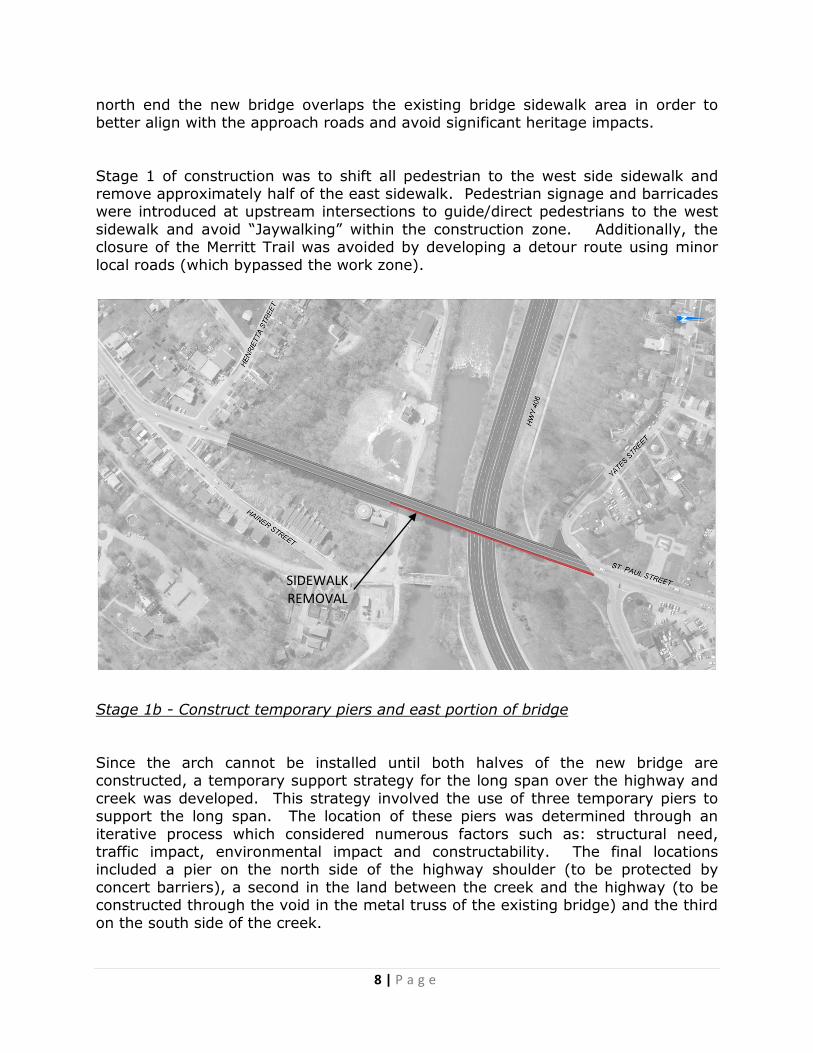
8 | P a g e
SIDEWALK REMOVAL
north end the new bridge overlaps the existing bridge sidewalk area in order to better align with the approach roads and avoid significant heritage impacts.
Stage 1 of construction was to shift all pedestrian to the west side sidewalk and remove approximately half of the east sidewalk. Pedestrian signage and barricades were introduced at upstream intersections to guide/direct pedestrians to the west
sidewalk and avoid “Jaywalking” within the construction zone. Additionally, the closure of the Merritt Trail was avoided by developing a detour route using minor
local roads (which bypassed the work zone).
Stage 1b - Construct temporary piers and east portion of bridge
Since the arch cannot be installed until both halves of the new bridge are constructed, a temporary support strategy for the long span over the highway and
creek was developed. This strategy involved the use of three temporary piers to support the long span. The location of these piers was determined through an
iterative process which considered numerous factors such as: structural need, traffic impact, environmental impact and constructability. The final locations included a pier on the north side of the highway shoulder (to be protected by
concert barriers), a second in the land between the creek and the highway (to be constructed through the void in the metal truss of the existing bridge) and the third
on the south side of the creek.
9 | P a g e
TEMPORARY PIERS
NEW EAST BRIDGE
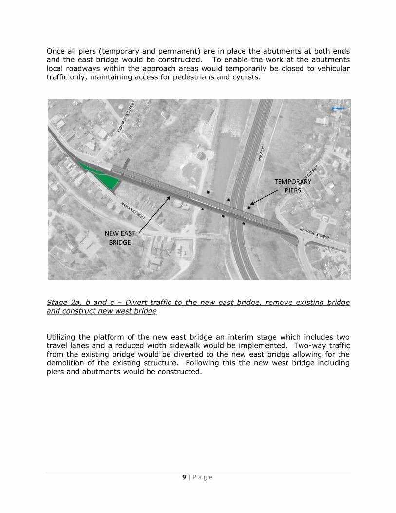
Once all piers (temporary and permanent) are in place the abutments at both ends and the east bridge would be constructed. To enable the work at the abutments
local roadways within the approach areas would temporarily be closed to vehicular traffic only, maintaining access for pedestrians and cyclists.
Stage 2a, b and c – Divert traffic to the new east bridge, remove existing bridge and construct new west bridge
Utilizing the platform of the new east bridge an interim stage which includes two
travel lanes and a reduced width sidewalk would be implemented. Two-way traffic from the existing bridge would be diverted to the new east bridge allowing for the
demolition of the existing structure. Following this the new west bridge including piers and abutments would be constructed.

10 | P a g e
Stage 3 – Assemble and Install Arch
For the installation of the arch, the loads on the two bridges need to be balanced as such, southbound traffic would be shifted to the new west bridge and the load
transferred from the temporary piers to the arch. A full closure of Highway 406 is
INSTALL
ARCH
TWO-WAY TRAFFIC ON
EAST BRIDGE
DEMOLISH EXISTING BRIDGE AND
CONSTRUCT NEW WEST BRIDGE
11 | P a g e
required for the arch installation and load transfer process. In addition the temporary piers will be removed and the site remediated. All trail detours will be
eliminated and trails reopened on their original alignments.
Traffic Management Plan – “Minimize”
For the Burgoyne Bridge the multi-stage implementation plan requires the partial or full closure of both St. Paul Street West, intersecting adjacent municipal roadways
at each bridge approach and the provincial highway, which runs beneath the bridge.
These roadways service a variety of modes (pedestrian, cyclist, transit, school bus, etc.) and serve as key response routes for the various emergency services.
Considering these requirements the traffic management plan was developed in conjunction with these agencies and area stakeholders (residents and businesses).
The plan consisted of three primary components:
Development of the details pertaining to closure types, durations and
detours associated with various construction activities during each stage Development of a communication strategy for disseminating the information
to all users of the impacted corridor(s) Development of an incident management plan for reducing the potential
impacts of accidents or disabled vehicles
The typical suite of traffic management strategies permitted by various road authorities (Municipal, Regional and Provincial) were reviewed and it was determined that the bridge implementation could not be achieved if restricted to
these traditional traffic management strategies. A tailor made solution was developed which was sensitive to the area specific needs and constraints. The
solution involved a series of more intrusive traffic management strategies along the provincial highway to allow for the implementation of various construction stages. These strategies along with a full suite of traffic management tools that could be
utilized by the contractor for this project were developed, some with no restrictions and others with some restrictions (e.g. time of day, number of occurrences,
duration, etc.). Due to the complexity of the project and environment it was decided that the contract documents would be developed to encourage innovation by not being overly prescriptive in the sequencing of the construction.
Plan Overview The traffic management plan included:
• Temporary encroachments onto Highway 406 resulting in the form of lane
closures, interchange closures and full mainline highway closures
12 | P a g e
• Temporary closure of St. Paul Street Bridge in the form of single lane closures and night time bridge closures
• Temporary closure/turn restrictions at adjacent municipal roadways at bridge approaches
• Temporary detour of the Merritt Trail under the Burgoyne Bridge
Highway Mainline Lane Restrictions
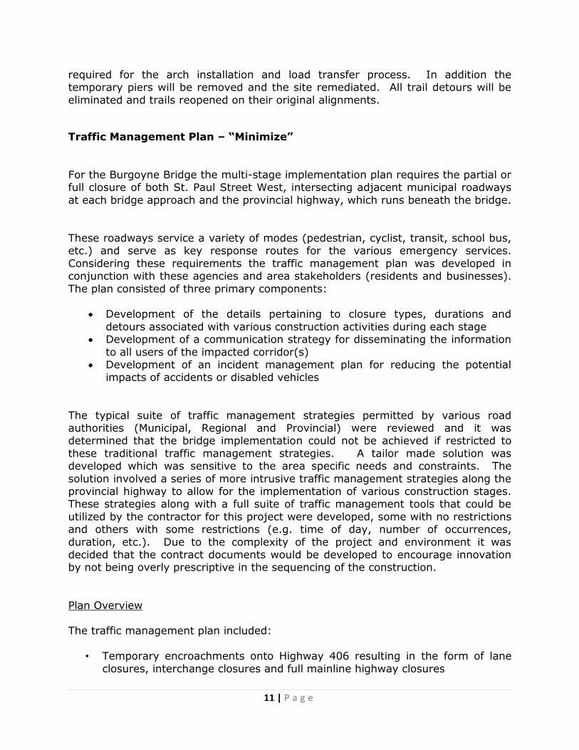
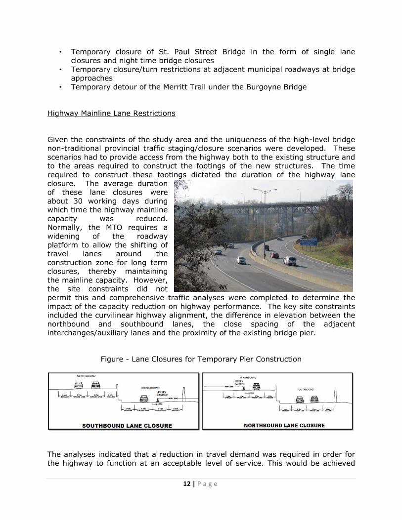
Given the constraints of the study area and the uniqueness of the high-level bridge non-traditional provincial traffic staging/closure scenarios were developed. These
scenarios had to provide access from the highway both to the existing structure and to the areas required to construct the footings of the new structures. The time
required to construct these footings dictated the duration of the highway lane closure. The average duration of these lane closures were
about 30 working days during which time the highway mainline
capacity was reduced. Normally, the MTO requires a
widening of the roadway platform to allow the shifting of travel lanes around the
construction zone for long term closures, thereby maintaining
the mainline capacity. However, the site constraints did not permit this and comprehensive traffic analyses were completed to determine the
impact of the capacity reduction on highway performance. The key site constraints included the curvilinear highway alignment, the difference in elevation between the
northbound and southbound lanes, the close spacing of the adjacent interchanges/auxiliary lanes and the proximity of the existing bridge pier.
Figure - Lane Closures for Temporary Pier Construction
The analyses indicated that a reduction in travel demand was required in order for
the highway to function at an acceptable level of service. This would be achieved

13 | P a g e
through a combination of static and variable message signage along the highway system as far back as 20km in each direction. Additionally, static and temporary
variable message signage would also be introduced along the regional road system. This would all be supported with a communication plan.
In summary, the following suite of tools was provided to the contractor to utilize in
their construction sequencing for the construction of the bridge:
Nightly lane closures as required (10:00pm-6:00am) Multi-day lanes closures, as required for the construction of caissons,
footings and temporary towers only
o Southbound lane & shoulder (3-24 days) o Northbound lane & shoulder (3-20 days)
Highway Mainline Closures
The other significant construction activities which would impact the highway included the demolition of the existing bridge spans over the highway and the
erection of the arch on the new bridge. During these activities all highway traffic must be stopped in order to ensure public safety. Traditionally, when activities occur over highway lanes the Ministry allows for the use of pace vehicles to create
gaps in traffic. These gaps are of short duration and there is risk of end of queue collisions during pace vehicle operations. The nature of construction activities is
such that they will require about two to three days to complete and would not be feasible for them to be undertaken in a ”stop and go” fashion that the pace vehicle scenario would create. The investigation of full highway closure and traffic
diversion to a parallel arterial roadway during the night time hours was undertaken.
A traffic analysis was completed and indicated that the night time highway traffic volumes could be accommodated on the arterial detour route. Utilizing this
approach it would take about ten days of consecutive night time closures to complete each of these tasks. This was considered to be very disruptive to the
highway users and not cost efficient both from the traffic control and construction perspective. In consultation with the MTO a final scenario was developed which minimized disruption to highway traffic and shortened the construction duration of
these activities. The approved traffic staging scenario included the full closure of the highway between the two adjacent interchanges to the Burgoyne Bridge for a
weekend. The closure would commence Friday evening and end early Monday morning.
This scenario would see all highway traffic diverted to a parallel arterial route. A
detailed traffic analysis was undertaken to determine the impacts to the city street system and identify any mitigation measures, turn restrictions or traffic control
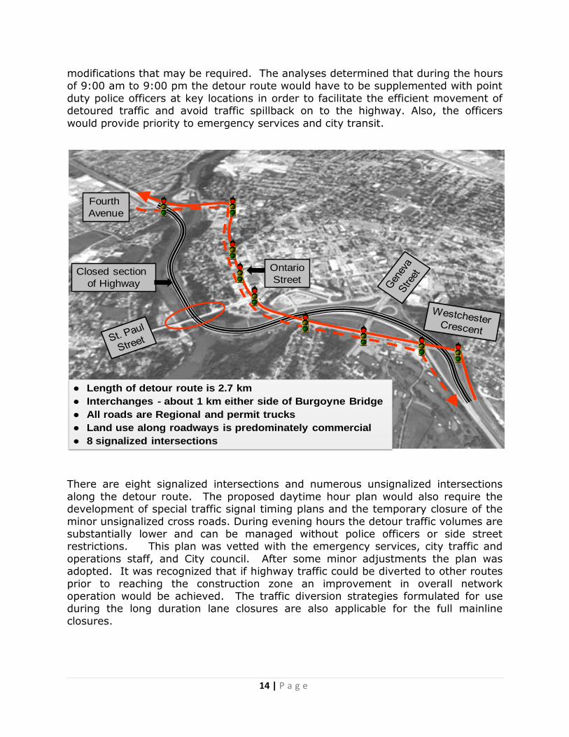
14 | P a g e
Fourth
Avenue
Ontario
Street
● Length of detour route is 2.7 km
● Interchanges - about 1 km either side of Burgoyne Bridge
● All roads are Regional and permit trucks
● Land use along roadways is predominately commercial
● 8 signalized intersections
Closed section
of Highway
modifications that may be required. The analyses determined that during the hours of 9:00 am to 9:00 pm the detour route would have to be supplemented with point
duty police officers at key locations in order to facilitate the efficient movement of detoured traffic and avoid traffic spillback on to the highway. Also, the officers
would provide priority to emergency services and city transit.
There are eight signalized intersections and numerous unsignalized intersections
along the detour route. The proposed daytime hour plan would also require the development of special traffic signal timing plans and the temporary closure of the
minor unsignalized cross roads. During evening hours the detour traffic volumes are substantially lower and can be managed without police officers or side street restrictions. This plan was vetted with the emergency services, city traffic and
operations staff, and City council. After some minor adjustments the plan was adopted. It was recognized that if highway traffic could be diverted to other routes
prior to reaching the construction zone an improvement in overall network operation would be achieved. The traffic diversion strategies formulated for use during the long duration lane closures are also applicable for the full mainline
closures.
15 | P a g e
In summary, the following suite of tools for highway mainline closures was provided to the contractor to utilize in their construction sequencing for the construction of
the bridge. The closures would extend from the Fourth Avenue interchange to the Westchester Crescent interchange:
Installation of steel girders, debris shield, deck falsework, barrier wall and
formwork over Highway 406
o Nightly highway closures as required (10:00pm - 6:00am - Weekday) o Nightly highway closures as required (10:00pm - 10:00am – Sat/Sun)
Removal of the existing bridge and erection of steel arch over Highway 406 o Nightly highway closures (Friday 10:00pm to Monday 6:00am)
Regional and Municipal Road Closures
The nature and type of construction activities required along the non-provincial
roadway are more conventional in nature and did not require non-traditional traffic management techniques. However, given the limited Twelve Mile Creek crossing
opportunities and the distance between them it is imperative that accurate and timely information is provided to the bridge users to allow them to make
appropriate travel choices to minimize the disruption to their trip. The construction activities throughout the project will have impact to all the various modes currently utilizing the Burgoyne Bridge. Bridge construction will result in the need to close or
restrict lanes on St. Paul Street. A summary of allowable restrictions was provided along with a list of blackout dates which represented special events and activity
time during which no closure/lane restrictions would be permitted.
St. Paul Street Full Closures
Weekday (Sunday through Thursday) nightly closures (10:00pm - 6:00am) permitted for:
• installation of debris shield over Highway 406 • removal of portion of existing sidewalk
• shifting of traffic onto new east bridge • construction of arch (erection of hangers, supports and ties etc.) • sidewalk removal and barrier wall work
St. Paul Street Single Lane Closures Permitted except for Monday to Friday between the following hours due to the
commuter nature of St. Paul Street West:
• 7:00 am to 9:30 am • 4:00 pm to 6:30 pm
16 | P a g e
Communication Plan – “Minimize and Mitigate”
A properly developed communication plan can both aid in the minimization of traffic
impacts/delays of planned events as well as assist in mitigating the severity of traffic congestion resulting from incidents/unplanned events.
A comprehensive communication plan was developed to target roadway/highway
users both at the origin of their trips and along the approaching roadways at locations where alternative route choices were available to them. This would allow individuals to adjust their travel patterns (timing and route choice) in order to
minimize disruption to their trip and reduce travel demand in the work zone. This will require the use of a variety of communication methods and media. The
following would be implemented for this project:
Press releases at regular intervals from the Niagara Region’s Communication
Group. These would be distributed to local radio, newspapers and local cable.
A project website will be established supplying data on construction progress and upcoming traffic closures/detours.
Static roadway information signs would be erected a minimum of two weeks prior to all traffic closures/detours
Portable Variable Message Signs (PVMS) along Highway 406 and St. Paul
Street West will be installed. The signs on the provincial highway will be linked to the Ministry’s traffic control centre and the others operated by the
Region/contractor. An EMS stakeholder group will be created which will include representatives
from Ontario Provincial Police, Regional Niagara Police, City Fire and Regional
ambulance services, City transit and school transit. This group will meet at key milestones preceding significant traffic closures/detours in order to
ensure they are prepared and contingency plans are in place. Also, this group will meet to debrief on previous closure events and determine whether modifications or adjustments are needed to the plans for future closures.
Under the long duration, highway lane reductions and the full highway closure scenarios where traffic diversion from Highway 406 is desirable and required, an additional level of communication extending beyond the list above was developed.
This communication strategy includes signage and driver information being provided at locations which increases the likelihood of an alternative route choice
being made. These locations extend to areas which are from 10 to 20 kilometres in advance of the construction area on the provincial system and two to five kilometres on the city and Regional roadway system. On the provincial system the
use of MTO’s freeway traffic system, highway advisory radio and non-local radio stations provide traffic information.
17 | P a g e
Incident Management – “Mitigate”
The success of the traffic management plan and the construction staging is
contingent on the safe and efficient movement of vehicles and other modes through the work zones. In order to ensure that this occurs, an incident management plan was developed in order to quickly respond to and clear collisions, disabled vehicles
or other incidents. In this plan the contractor will have to provide a 24/7 incidence response team to secure the incident site and expedite the reopening of the
impacted area. This response team will be responsible for both the Regional/City streets and the portion of the provincial highway under their control (e.g. within the construction zones). Integral to the success of this plan is timely communication of
the incident information to the travelling public in order for them to respond accordingly. The incident management team leader would provide direct
communication to the Region’s communication manager from which an information release to appropriate agencies and/or media would be undertaken.
Summary
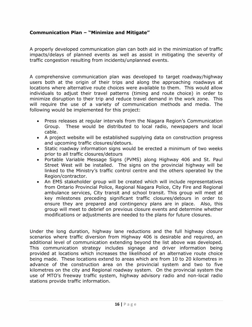
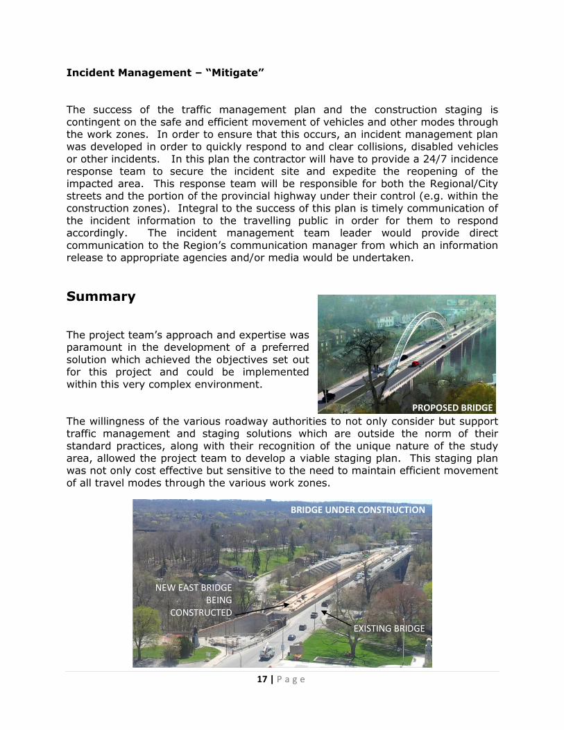
The project team’s approach and expertise was paramount in the development of a preferred
solution which achieved the objectives set out for this project and could be implemented
within this very complex environment.
The willingness of the various roadway authorities to not only consider but support traffic management and staging solutions which are outside the norm of their
standard practices, along with their recognition of the unique nature of the study area, allowed the project team to develop a viable staging plan. This staging plan was not only cost effective but sensitive to the need to maintain efficient movement
of all travel modes through the various work zones.
PROPOSED BRIDGE
BRIDGE UNDER CONSTRUCTION
NEW EAST BRIDGE BEING
CONSTRUCTED
EXISTING BRIDGE