geodesia spaziale - unibo.itcorsi.unibo.it/fisica-laurea/documents/preslm/pres_lm10_ft_2.pdfgeodesia...
TRANSCRIPT

GeodesiaGeodesia SpazialeSpaziale
GeodesiaGeodesia
forma,forma, dimensionidimensioni e campo di e campo di gravitàgravità delladella TerraTerra
e e loroloro variazionivariazioni temporalitemporali

Sputnik 1Sputnik 1
Sputnik 1Sputnik 1
More than twice the size More than twice the size
of a basketballof a basketball
October 4, 1957 October 4, 1957
Sputnik 2Sputnik 2
Larger and heavierLarger and heavier
November 3, 1957November 3, 1957
In the late 1950’s, only 3 or 4 coefficients of the gravity In the late 1950’s, only 3 or 4 coefficients of the gravity
field had been estimated and global geocentric field had been estimated and global geocentric
coordinates were known to perhaps 500 m.coordinates were known to perhaps 500 m.

Modified from Cazenave and Feigl, 1994
Line of nodes
Perturbed Keplerian orbit

3 SLR systems at Grasse3 SLR systems at Grasse
The targetsThe targets
Courtesy of ILRS Courtesy of ILRS
MLROMLRO

A broad range of applications in A broad range of applications in
support of Earth System Sciencesupport of Earth System Science
•• monitoring crustal deformationmonitoring crustal deformation
•• seasea--level variations/changeslevel variations/changes
•• space weatherspace weather
••………………....


After NASA data base, Heflin et al. 2001.8After NASA data base, Heflin et al. 2001.8

1998 1999 2000 2001 2002 2003 2004 2005 2006 2007 2008 2009 2010
99.58
99.60
99.62
99.64
99.66
99.68
99.70
-9.41± 0.05 mm/yr
Height (m)
Time
Bologna
1995 1996 1997 1998 1999 2000 2001 2002 2003 2004 2005 2006 2007 2008 2009 2010
44.22
44.24
44.26
44.28
44.30
44.32
-6.24± 0.02 mm/yr
Height (m)
Time
Marina di Ravenna

IGS network of over 350 stationsIGS network of over 350 stations
221 stations221 stations
Orbits accuracy <5 cm Orbits accuracy <5 cm
PositionsPositions
VelocitiesVelocities
Horizontal 3 mmHorizontal 3 mm 2 mm/yr2 mm/yr
Vertical 6 mmVertical 6 mm 3 mm/yr3 mm/yr
Latency ~13 daysLatency ~13 days
Polar motion, PM rate, LOD, Polar motion, PM rate, LOD,
zenith tropospheric path delay, zenith tropospheric path delay,
ionospheric TECionospheric TEC
ProductsProducts
Weekly coordinate estimates (~Weekly coordinate estimates (~
cm)cm)
Time series analysisTime series analysis
Zenith path delay Zenith path delay
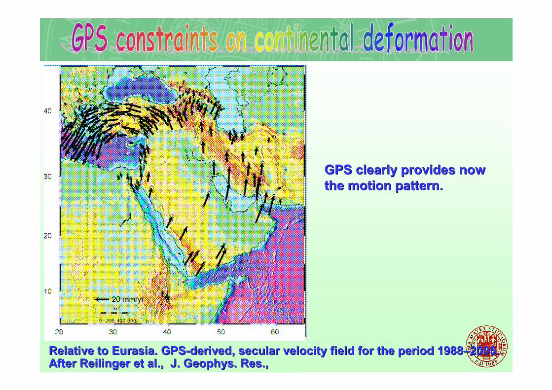
After After ReilingerReilinger et al., J. Geophys. Res., et al., J. Geophys. Res.,
BO5411, 2006BO5411, 2006
GPS clearly provides now GPS clearly provides now
the motion pattern.the motion pattern.
Relative to Eurasia. GPSRelative to Eurasia. GPS--derived, secular velocity field for the period 1988derived, secular velocity field for the period 1988––2005. 2005.

TopexTopex//PoseidonPoseidon(1992(1992--2006)2006)
JasonJason--1 (20011 (2001-- ) ) JasonJason--2 (20082 (2008-- ))
Courtesy of A. Courtesy of A. CazenaveCazenave

uncertainty ~0.4 mm/yr
Rate: 2.5 +/- 0.4 mm/yrover 2003-2008
Courtesy of A. Courtesy of A. CazenaveCazenave

Sea level is still rising but causes are different:
1993-2003 : Ocean thermal expansion 50%Land ice 40%
2003-2008 : Land ice 80%!
Ocean thermal expansion: <20%
Courtesy of A. Courtesy of A. CazenaveCazenave

Monitoring of mass transport has Monitoring of mass transport has
startedstarted
Monthly mapping of the gravity field over Monthly mapping of the gravity field over
spatial scale from 400 km to 40,000 kmspatial scale from 400 km to 40,000 km

Courtesy of ESACourtesy of ESA
March 17, 2009March 17, 2009
LongLong--time waited for and needed! time waited for and needed!
Mapping the Earth gravity field with Unprecedented accuracy Mapping the Earth gravity field with Unprecedented accuracy
Spatial resolution 100 kmSpatial resolution 100 km
11--2 cm 2 cm geoidgeoid

From ESA SPFrom ESA SP--13041304
Planet Earth is a Planet Earth is a
complex, interconnected complex, interconnected
system. To build an system. To build an
understanding of the understanding of the
whole system requires whole system requires
an increase in our an increase in our
knowledge of its knowledge of its
components and the components and the
ways these interact.ways these interact.

Operational numerical Operational numerical
weather prediction 5weather prediction 5--day day
forecasts of 500forecasts of 500--hPa hPa
geopotential heights over geopotential heights over
the Northern and Southern the Northern and Southern
Hemisphere.Hemisphere.
Operational oceanography 7Operational oceanography 7--
day forecast of seaday forecast of sea--level level
anomaly over the tropical and anomaly over the tropical and
North Atlantic North Atlantic
(courtesy of N. Ferry)(courtesy of N. Ferry)