construction of the alcan highway in 1942 - missouri …rogersda/umrcourses/ge342/alcan...
TRANSCRIPT

Construction of
the Alcan Highway
in 1942
“One of the Top 10 Construction
Achievements of the 20th Century”
J. David Rogers, Ph.D., P.E., P.G. Karl F. Hasselmann Chair in Geological Engineering
Missouri University of Science & Technology

Outline • Purpose of the Alaska-Canadian Highway
• Corps of Engineers Mission
– Specifications
– Plan of attack
• Surveying the land
• Construction of the pioneer road
– Plan of Attack
– Problems
– Culverts
• Bridges and Pontoons
– Use of Pontoons
– Maintenance
• Billeting structures
• African American involvement
• Final Details of the Alcan Highway

Purpose of the Alcan
Highway • Since the 1930’s there had been discussions about
developing a road that would link the western United States to Alaska.
• There was not a strong push for the development of the highway until the Japanese defeat of the American Pacific Fleet at Pearl Harbor on December 7, 1941.
• Military planners realized how vulnerable Alaska was to seaborne attack and invasion. It was decided to develop a land link to our small forces in Alaska and for the airfields currently located and planned between Seattle, Washington and Fairbanks, Alaska.
• This dream became the Alaska-Canadian, or Alcan Highway

• On June 4, 1942 Japanese carrier-based aircraft attacked
Dutch Harbor on the Alaskan Coast and occupied Attu
and Kiska, in the western Aleutian Islands.

Strategic Position of Alaska
Traverse Polyconic Projection Showing Strategic Location of Alaska

Army Corps of Engineer’s
Mission • The Corps’ mission, under the guidance of BGEN Clarence L.
Studevant, was to build a pioneer road suitable for supply trucks as
fast as humanly possible. Civilian contractors working for the U.S.
Public Roads Administration (PRA) will then upgrade the road to
status of a permanent highway.
• SPECIFICATIONS
Clearing: 32 feet wide minimum
Grade: 10% maximum
Curves: 50 foot radium minimum
Surfacing: 12 feet minimum
Shoulders: 3 feet minimum
Ditch depth: 2 feet
Crown: 1 inch per foot maximum
Bridges: Single lane with H15 minimum loading

Plan of Action
• Provide aerial photos to route survey parties to provide general location and bearing.
• Using bearing, surveyors blaze trail and mark center line by tying red cloths to bushes and trees.
• A plane table party would then traverse the alignment and record relative elevations.
• If this preliminary pass along the proposed alignment proved satisfactory, construction units would begin dozing.
• Civilian contractors followed to improve the pioneer road cut by the Army Engineers.

Survey Party recording and
marking center line

Pathfinding Methodology • When the first surveyors of Company D, 29th Engineer Topographic Battalion and
Company A of the 648th Engineer Topographic Battalion hit the ground in
February of 1942, the base maps were simply aerial photographs.
• Only one map was provided of the area from Dawson Creek to Fort Nelson.
• Paucity of maps and snow up to 18 inches deep posed the biggest problems for
the route surveyors. Other problems were the mosquitoes, gnats, and yellow
jaundice.
• The surveyors also had to comply with orders to have the pioneer road service
the airfields in the Yukon Territory and Alaska, as well as avoiding steep terrain
and muskegs, as much as possible.
• A survey party would normally consist of 1 Officer and 9 Surveyors. The first
group to enter the forest would split up into teams and venture out for a mile or
two to see which alignments held the greatest potential. The teams would then
back track and reunite. This separating and coming back together, along with
updated aerial photos, was the only way for the surveyors to blaze the best path.
• Another survey team would follow behind, running a level survey and tape the
centerline. Shortly behind them came the transit team that would record the
centerline and elevations of the proposed road.
• The teams would average about 2 to 4 miles per day. They used local Indians as
guides.

Route surveying was made difficult by the adverse weather and
heavy vegetation, which limited sighting distance

A traverse team and recorders
do final calculations to verify
that the intended road meets
specifications.
These shots show two of the plane
table survey teams, who fixed
vertical elevations along the path

LOGISTICS NIGHTMARE
Getting the necessary supplies to
the engineer troops was the greatest
obstacle during the project,
especially fuel and oil for the trucks,
machinery, and stoves

DOG SLEDS • With no defined road established during surveying,
supplies were brought to the parties either by dog sled
teams or horses. From the start, the supply team
would leave with a month’s supply carried by dog
sleds.

Construction of Pioneer Road • The first Engineer Construction regiment (341st) arrived on March
10, 1942 at Dawson Creek. They started north to St. John. Their
initial goal was to get past Peace River just north of St. John before
the spring thaw. Otherwise, they had no means of transporting
their equipment any farther.
• By June of 1942, seven engineer regiments were on the ground
and constructing the pioneer road. Each regiment was assigned a
strip of land approximately 350 miles long. Their goal was to reach
the next regiment’s pioneer road before winter set in.
18th Engineer Combat Regiment
35th Engineer Combat Regiment
93rd Engineer General Service Regiment (colored)
95th Engineer General Service Regiment (colored)
97th Engineer General Service Regiment (colored)
340th Engineer General Service Regiment
341st Engineer General Service Regiment


Leap Frog Grading • Within each Regiment, the companies constructed a portion
of the road using a leap-frog method. One company would
grade their assigned section, another just ahead of them
(about 30 miles). When a company worked up to the next
company’s road, then they would “leap ahead” and start
again.
• During the spring and summer months, daylight could last
up to 20 hours with twilight for the remaining 4 hours. This
allowed the construction crews to work 3 shifts of 8 hours
each, round the clock.
• The units only had a short supply of equipment until the
arrival of heavier equipment (CAT D-7’s and D-8’s). For the
most part, they were using hand saws, hand axes, and small
D-4 bulldozers. Building the road took a lot of brute force
and creativity.

For the first few months of construction, the Engineers
had to use muscle and determination to blaze a road.

Until heavier equipment arrived, the Engineers had to
be creative, using local supplies to continue
construction. Here, a D-4 dozer pulls a makeshift
grader crafted from local timber.

Once the heavier equipment arrived, clearing a path
became easy. Here a D-8 bulldozer clears a path.

Excavation & Grading
Army Engineers used the best equipment available at the
time, including Dodge and GMC dump trucks, various
crawler tractors, like the D-4 shown here, and Letourneau
Carryall scrappers. A decade earlier very little of this
earthmoving equipment existed.

• The treatment of areas other than drainage zones were best addressed
using gravel fills, as shown here. Once frozen, the gravel reacts more
favorably than other fill materials, and serves to broaden the base of the
highway. Care was taken to remove excess quantities of fine sand and
silt which tended to heave when the fill froze.

Improvising was obligatory
Left – Soldiers using an Ingersoll-Rand pneumatic drilling rig
to excavate blast holes for a rock cut
Right – Small dozer pulling a log dump sled, which were
fashioned by the men on site to better spread loads on the
mushy, muddy ground

• The biggest surprise on the project was the ability of modern American
equipment to make short work of excavating the highway across
mountains, which a few years previous, would have required expensive
and time-consuming tunneling. This shows the pioneer road, before the
grade was dropped another 22 feet.

Father of “Permafrost”
• In 1943 Stanford University
Geology Professor Si Muller was
loaned to the Army by the USGS
to provide insights on the frozen
ground conditions in Alaska
because he wrote and spoke
fluent Russian, and all of the
published literature on this
subject was then in Russian
• It was Muller who originally coined
the term “permafrost” to describe
permanently frozen ground
• He remained in Alaska until 1945,
and published the first book on
engineering problems with
permafrost in 1947.
Professor Miller wearing the uniform of
a US Army officer in Alaska in 1944, but
without any rank. His second book was
published posthumously by ASCE in
2007.

Permafrost is the permanently frozen subsoil beneath
cover of vegetation and top soil (the active layer). The
active layer topsoil insulates the frozen subsoil.
Types of Permafrost
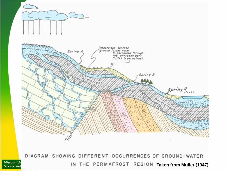
Taken from Muller (1947)
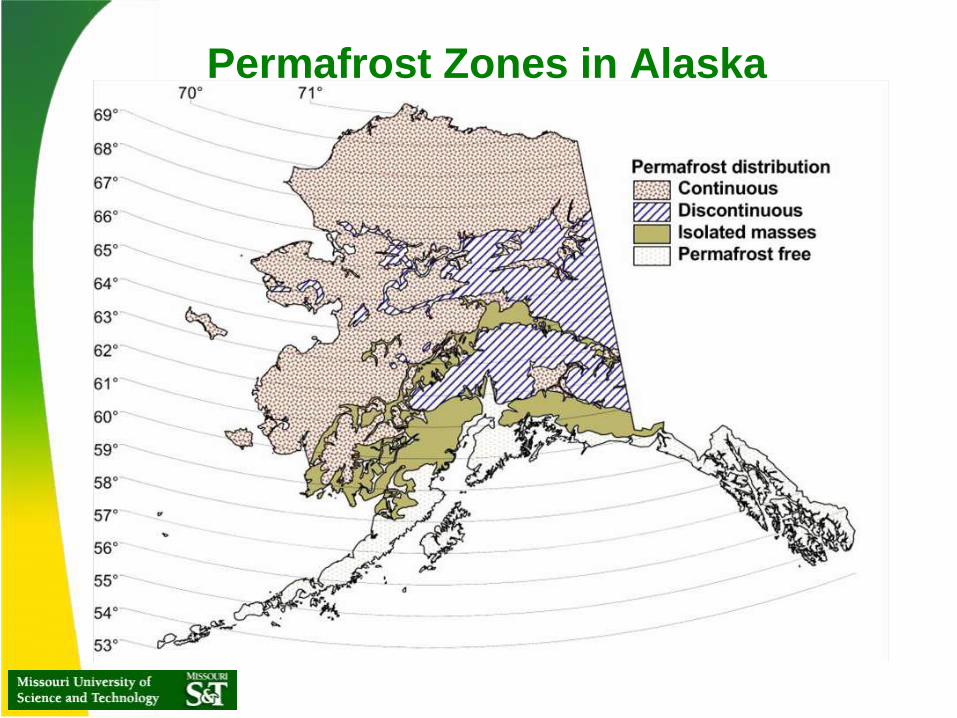
Permafrost Zones in Alaska

Inclusions of glacial
ice are commonly
found in
permafrost.
These were
impediments to
grading, like large
boulders.

SOLIFLUCTION
• Soils in the thawed active layer overlying the permafrost
tend to creep downslope during the warm season
through a process known as “solifluction.” This process
is exacerbated by the inability of percolating rainfall to
penetrate the permafrost, leading to the active layer
becoming super saturated.

Frost Blisters • Seasonal percolation is
restricted to the active
zone, just beneath the
ground surface
• When the ground begins to
freeze, flow becomes
blocked, leading to the
formation of “frost
blisters,” as shown in the
center sketch
• These blisters occasionally
“erupt,” releasing water to
the surface, which then
becomes frozen.

Differential
Settlement
Heat radiated by structures or their supporting elements can trigger differential
settlement by thawing portions of the underlying permafrost

MUSKEGS are like a muddy version of quicksand. A
vehicle would pass through a muskeg once, but within a
short time, the area would turn into liquid mud, losing shear
strength. Once caught, a vehicle had to be pulled out.

Roadside drainage
failure in permafrost
• The roads subgrade was
almost completely
undermined by thawing of
permafrost, which resulted
in the sloughing of the
saturated soil.
• This problem was caused by
the excavation of the
roadside ditch, which was
unnecessary
• The problem was
exacerbated by drifting in fill
from adjacent to the highway
to fill in the collapsing ditch,
as shown in the lower figure
at left

A road in a muskeg without corduroy surfacing.
The dozer is fine ridding on the permafrost until
it encounters a unfrozen muskeg.

• Old Caterpillar tractor trails excavated on permafrost allowed water
to pond and infiltrate zones adjacent to the Alcan Highway, causing
it the highway subgrade to be undermined.
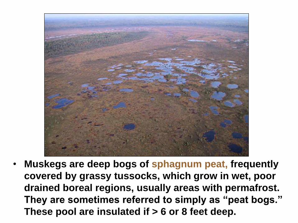
• Muskegs are deep bogs of sphagnum peat, frequently
covered by grassy tussocks, which grow in wet, poor
drained boreal regions, usually areas with permafrost.
They are sometimes referred to simply as “peat bogs.”
These pool are insulated if > 6 or 8 feet deep.

• Muskegs sometimes appeared to “swallow” the
heavier equipment, then exhibiting thixotropy, by
“setting up.”

OVERCOMING MUSKEGS
• To overcome the liquid mud created by
disturbed Muskegs, the Engineers laid
corduroy, just like the Romans.
• Corduroy road surface is constructed by first
laying piles of brush, then logs, then more
brush, and more logs, and finally a layer of
gravel.
• In one stretch, two miles of corduroy was laid.
Overall, over 100 miles of muskeg was
corduroyed in this manner.

Corduroy road surface under construction. Some 100 miles (160 km) of
route between Burwash Landing and Koidern, Yukon, became nearly
impassable in May and June 1943, as the permafrost thawed, no longer
protected by a layer of delicate vegetation. A corduroy road was built to
restore the route, and corduroy still underlays old sections of highway in the
area.

• In reviewing the Russian technical literature, Muller
soon discovered that they employed shoulder berms to
check shoulder slumping and deterioration.

Thawed permafrost
becomes swampy
• When constructing a road, it
is common procedure to
remove the topsoil. But,
when the active layer was
excavated, the underlying
permafrost thaws out and
deforms easily because of
the high water content.
• Stabilizing fill berms on
either side of the highway
fill prism help to alleviate
this problem, as shown here

• Seasonal permafrost problems were the largest engineering problem to overcome in maintaining the Alcan Highway. Most of these were described in S.W. Muller, Permafrost or Permanently Frozen Ground and Related Engineering Problems, 1943.

SOLVING THE PROBLEM
• Drainage trenches and diversion berms had to be
constructed upslope of highway embankments to
control seepage during seasonal thaw, as sketched
here.

• Portable sawmill operations set up by one of the regiment’s
sawmill companies. Prior to the Army’s January 1943
reorganization, Combat Engineer Regiments included quarry,
sawmill, construction, and camouflage companies.

• Log box culverts were used everywhere along the
highway to speed up construction because timber was
the only material that was readily available.
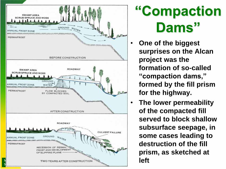
“Compaction
Dams” • One of the biggest
surprises on the Alcan
project was the
formation of so-called
“compaction dams,”
formed by the fill prism
for the highway.
• The lower permeability
of the compacted fill
served to block shallow
subsurface seepage, in
some cases leading to
destruction of the fill
prism, as sketched at
left

• “Compaction dams” could also trigger wholesale landslippage
along even the smallest culverts, as sketched here.

• Wooden stave pipe culverts were the most common
type used on the ALCAN Highway, usually fashioned by
the Engineer Regiments’ saw mill companies.

• This drainage ditch was cut by a dozer to channel discharge from a
culvert to the Tanana River in 1942. Within a year this seemingly
innocent ditch had excavated itself over 80 vertical feet, as a result
of exposing permafrost to thaw.

LARGE TIMBER CULVERTS • The larger culverts were
generally constructed from
the surrounding wood.
• They were intended to be
temporary until the
contractors came through to
improve the road.
• Here you see construction
of one of these temporary
culverts. After the wood
frame was erected, a brush
layer was placed to protect
the supporting logs and
prevent the base course
from sifting through. A
bulldozer would then fill and
level the basecourse over
the top of the timber culvert.
Dozer drifting roadway fill over a protective evergreen
brush layer that served as an effective filter and aerator,
protecting the logs from dry rot and preventing the fill
from spilling through the slits between the logs.

Bridges and Pontoons • Throughout the construction of the Alcan Highway, Army
Engineers crossed more than 200 rivers. During the colder
months, most traffic crossed ice-covered rivers and forded
the smaller streams. Once the spring thaw arrived, the 73rd
and 74th Engineer Light Pontoon Companies went to work
constructing temporary pontoon bridges.
• The first bridges constructed by the Army Engineers were
temporary. They failed when the spring thaw increased
water levels. Spring freshets also brought flotsam in the
form of tree trunks and brush, which slammed into the
pilings, damaging them and capturing more and more debris
because of the obstructions.
• When the water levels were high during the spring thaw and
flood seasons, equipment crossed the swollen rivers by
ferry or treadway pontoon bridge.
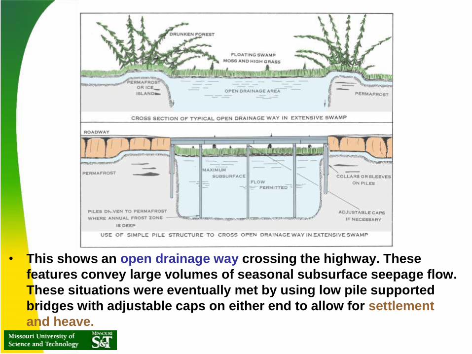
• This shows an open drainage way crossing the highway. These
features convey large volumes of seasonal subsurface seepage flow.
These situations were eventually met by using low pile supported
bridges with adjustable caps on either end to allow for settlement
and heave.

Use of Pontoons to support
construction • A temporary pontoon
bridge used to expedite construction.
• Pontoons ferrying
across equipment
These views show combat engineers erecting the old prewar
pontoons, only capable of supporting 15 ton/axle loads.

Pontoon bridges were of the prewar type, which were not suitable for
heavy loads or sustained operations by bridging companies. Civilian
contractors were brought in to construct timber trestle crossings of
most rivers and streams.

• The pontoon bridges and
ferries were only temporary
solutions until permanent
bridges could be built.
• Using three sawmills,
construction crews and
members of the Public Roads
Administration constructed
bridges along the entire
alignment, even during winter.
SEASONAL
BRIDGES

PRA crews and civilian contracting firms built most of the timber trestle
type bridges, which were expedient but temporary. The timber was
harvested onsite. All of these were eventually replaced with more
permanent timber, concrete, or steel bridges. Some the timber bridges
lasted into the 1980s.
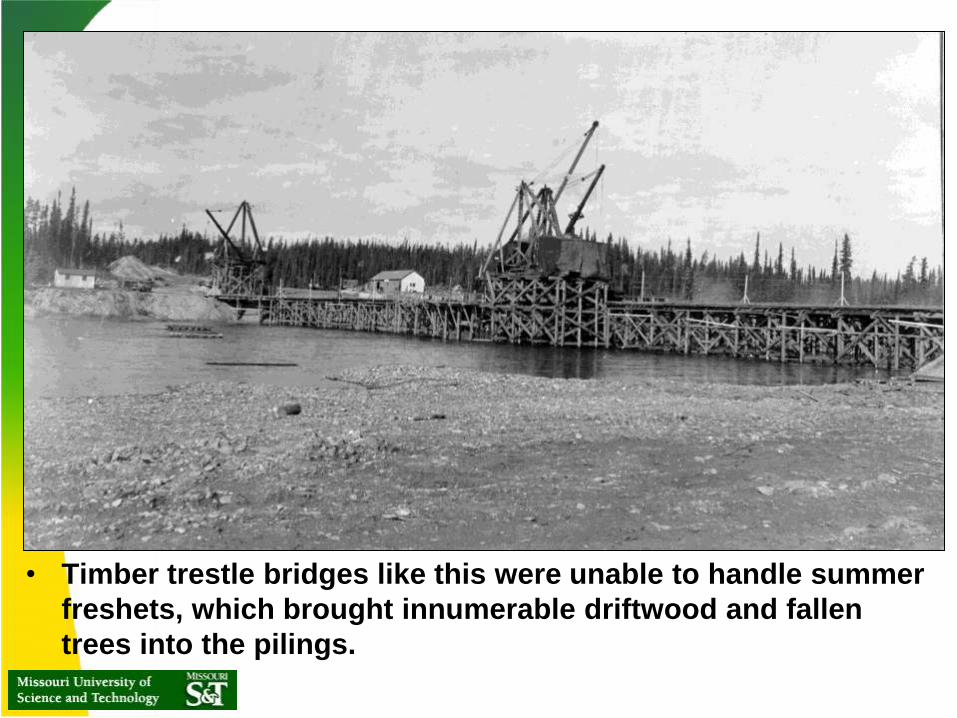
• Timber trestle bridges like this were unable to handle summer
freshets, which brought innumerable driftwood and fallen
trees into the pilings.

Maintaining Bridges • Maintaining the bridges posed the biggest problem. During
construction, a guard was posted to make sure that large trees brought downstream did get snagged by the bridge pilings, which could easily damage or destroy the bridge.

Airfields
Airfields were constructed
across the Northwest
Territory, Yukon, and
Alaskan frontiers to
protect American bases
and stage patrols

Snow piled along shoulders of
Alaskan runways often
prevented the active layer from
thawing, leading to deterioration
of the shoulders, as shown at
lower right.
Effect of snow piled on
shoulders of runways

Billeting the workers
• Left – Tarpaper Huts were commonly employed for billeting troops at
training facilities all over the world
• Right - Jamesway Huts were fashioned from multiples of 4’ x 16’
hemispheres, produced by the James Manufacturing Co of Fort
Atkinson, Wisconsin. These used wooded ribs and insulated fabric
covering, the only metal parts being nails, fasteners, and connecting
bars.

Provision of
temporary
and more
permanent
housing
• This shows the erection of 20’ x
48’ prefabricated wood huts for
billeting base personnel. These
were made of plywood and
shipped all over the world,
especially for Army Air Corps
facilities.
Pallets of prefabricated
wood huts, stockpiled onsite

• Portaseal Huts were a Canadian version of
the wood framed plywood clad Quonset Huts.
They were precut at the factory and could be
erected very quickly.
Portaseal Huts

• Portaseal Huts utilized a tar-paper exterior nailed to
plywood sidewalls, end walls with large windows, and
wide batten-type trim boards over the joints.

• Portaseal Huts were used on the Canol Pipeline Project and
on the Alaska Highway, where it crossed the Yukon Territory.
They were heated with improvised oil drum stoves.

• This view shows 24’ x 60’ Quonset-Redesign Huts, which appeared
in 1943. These used a lighter I-shaped steel arch with four foot
high vertical walls. Note canvas tents that provided temporary
quarters during erection.

• 20’ x 48’ Stran Steel Quonset Huts were manufactured in
Detroit and were the third and final design employed during
World War II. Note the ventilators. The men in the
foreground are walking on the floor ribs of a much larger
structure under construction.

• Wood frame structures were
normally constructed for
military bases, as seen in these
images from Attu. These views
show a motor pool structure at
lower left, and a dispensary
being disassembled and moved
using dozers and skids.
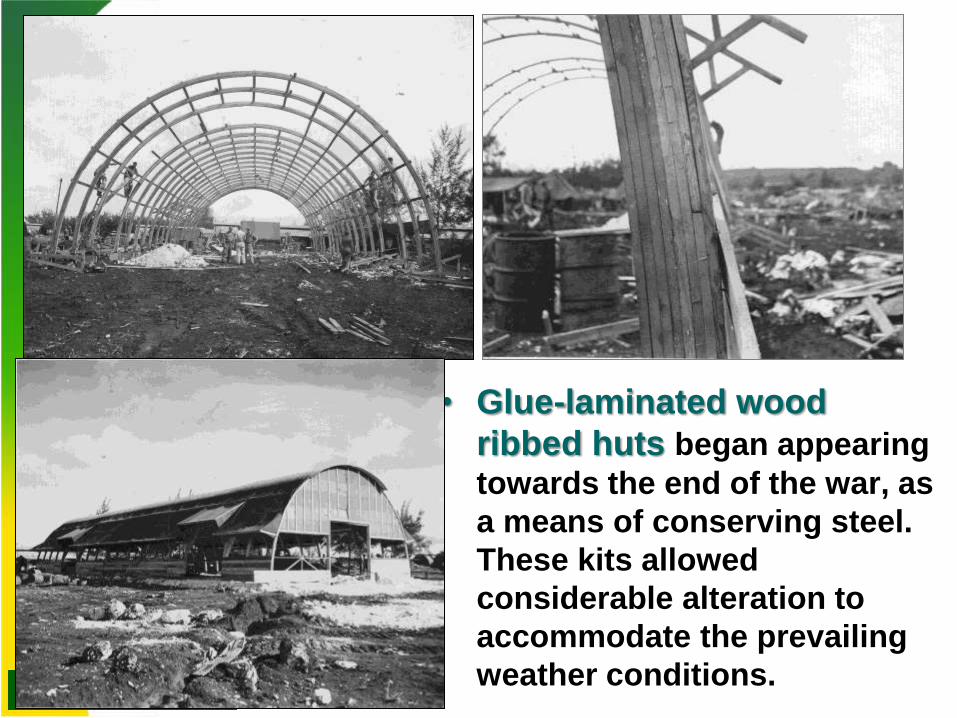
• Glue-laminated wood
ribbed huts began appearing
towards the end of the war, as
a means of conserving steel.
These kits allowed
considerable alteration to
accommodate the prevailing
weather conditions.
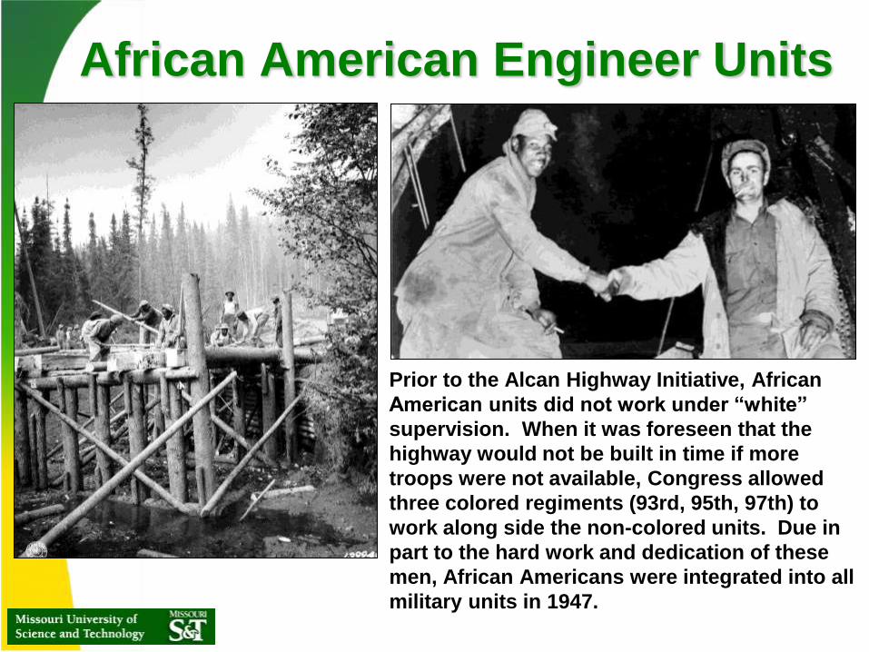
African American Engineer Units
• Prior to the Alcan Highway Initiative, African
American units did not work under “white”
supervision. When it was foreseen that the
highway would not be built in time if more
troops were not available, Congress allowed
three colored regiments (93rd, 95th, 97th) to
work along side the non-colored units. Due in
part to the hard work and dedication of these
men, African Americans were integrated into all
military units in 1947.

The Alcan Road
Today
The highway serves as an artery for all
manner of traffic, even offroad mining
rigs like the one shown here.
Jeep on the ALCAN in 1944

What a bridge on the Alcan
Highway looks like today

Final Details of the Alcan
Highway • The highest pass is only above 4,000 feet elevation, as opposed to
the initial predicted elevation of 6000+ feet.
• There are over 200 bridges (H20 and H15) and 8,000 culverts along
the highway
• Final specification of the highway:
Highway Army Pioneer Public Roads Administration
Feature Road (1942) Finished Road (1943)
Road width 12 feet minimum 24 feet
Shoulders 3 feet minimum 6 feet maximum
Grades 10% maximum 7% maximum; 5% average
Curves < 50 foot radius 717 foot radius
Surface compacted earth 2 feet crushed stone and gravel
Bridges one-way H-15 loads two-way H-20 (20 tons/axle)

CONCLUSIONS
• All the locals thought that a road through the
wilderness would be impossible. Not only did the
Corps of Engineers construct a road through the
Yukon Territory to Alaska, they did it in a record time
of 8 months and 11 days!
• Total pioneer road constructed: 1,543 miles
• 10,670 Engineers were used to construct and improve
a total of 1,685 miles of highway. 41 American and 13
Canadian contractors assisted in the construction
and improvement of the highway.
• November 20, 1942 marked the official opening of the
Alcan Highway. It has been in continuous operation
ever since.
REFERENCES
Part 1
• Alcan: America’s Glory Road, an Engineering News-Record Report
(1943)
• Van Rensselaer Sill (1945), American Miracle , Odyssey Press, New
York
• Richard Finnie (1945), Canol: the Sub-Arctic pipeline and refinery
project constructed by Bechtel-Price-Callahan for the Corps of
Engineers, U.S. Army 1942-44, San Francisco
• Siemon William Muller (1947), Permafrost of Permanently Frozen
Ground and Related Engineering Problems, J. W. Edwards, Ann Arbor.
• Highway Research Board, Military Road Construction in Foreign
Theaters (1949), National Research Council, Washington, DC.
• Royal Canadian Engineers, Highway Maintenance 1946-1964

REFERENCES
Part 2
• Royal Canadian Engineers, Highway Maintenance 1946-1964
• John K. Lloyd and Helen Navratil (1992), Alcan Trail Blazers:
men of Company “A,” 648th Engineer Topographic Battalion.
648th Memorial Fund
• Stan Cohen (1992). ALCAN and CANOL, Pictorial Histories
Publishing Co., Inc. , Missoula.
• Siemon W. Muller, and H.M. French and F.E. nelson, eds.
(2007). Frozen in Time: Permafrost and Engineering Problems,
ASCE Press, Reston.
• U.S. Army Corps of Engineers Archives, Fort Leonard Wood