climatic and environmental change in africa during the
TRANSCRIPT
CLIMATE RESEARCHClim Res
Vol. 17: 123–144, 2001 Published August 15
1. INTRODUCTION
Africa is one of the world’s largest continents, cover-ing over 30 million km2 and including over 45 coun-tries. The region’s environment is closely linked with
its climate, so that climatic constraints have been amajor force in the development of vegetation, soils,agriculture and general livelihood. This article summa-rizes what is known about African climate and envi-ronment during the past 2 centuries. It will commencewith a discussion of regional climate, then continuewith historical climate reconstruction for the 19th cen-tury, based on proxy and actual data. Then trends of
© Inter-Research 2001
*E-mail: [email protected]
Climatic and environmental change in Africaduring the last two centuries
Sharon E. Nicholson*
Department of Meteorology, Florida State University, Tallahassee, Florida 32306, USA
ABSTRACT: Climatic and environmental changes in Africa during the last 2 centuries have beenexamined, using both systematic rainfall records and proxy information concerning lakes and riversand the occurrence of famine and drought. The rainfall records provide excellent detail for the20th century. The proxy data have been used to produce a semi-quantitative data set spanning mostof the continent and having an annual time resolution. These provide an overview of conditionsduring the 19th century. Various issues related to the causes of these 2 centuries of variability are alsoconsidered: atmospheric and oceanic processes, desertification, surface albedo, mineral dust andhydrological feedbacks. The most significant climatic change that has occurred has been a long-termreduction in rainfall in the semi-arid regions of West Africa. This was on the order of 20 to 40% inparts of the Sahel. There have been 3 decades of protracted aridity. Nearly all of Africa has beenaffected by increased aridity, particularly since the 1980s. Few changes in temperature have beendemonstrated. These have occurred on a much smaller scale and are of considerably lower magni-tude than those over the continents. The rainfall conditions over Africa during the last 2 to 3 decadesare not unprecedented. A similar dry episode prevailed during most of the first half of the 19th cen-tury. By mid-century, conditions more typical of the ‘normal’ for the current century again prevailed.Thus, the 3 decades of dry conditions evidenced in the Sahel are not in themselves evidence of irre-versible global change. On the other hand, the processes controlling rainfall over most of the conti-nent are now reasonably well understood. One of the most important factors, particularly in theSahel, is sea-surface temperatures. It has been hypothesized that anthropogenic changes in the landsurface, particularly land use change and desertification, have contributed significantly to the declinein rainfall. Current evidence suggests that if changes in the land surface (e.g., vegetation cover, sur-face albedo, soil moisture) signficantly impact climate, they are much more strongly controlled bynatural climate variations, such as the recent decline in rainfall, than by human-induced land-usechange or degradation. Unfortunately, we still do not have any accurate large-scale assessments ofthe extent, nature and degree of such changes. The dreaded ‘desertification’ process appears to beconfined to relatively small scales. However, there is still cause for concern because the net effect ofthe various feedback processes involved in land degradation appears to be destabilization of ecosys-tems. Thus, a priority must be large-scale monitoring of the land surface and estimates of the degreeof change.
KEY WORDS: Africa · Climate · Rainfall · Environment
Resale or republication not permitted without written consent of the publisher

Clim Res 17: 123–144, 2001
rainfall observed instrumentally during the 20th cen-tury will be described. This material will be synthe-sized into a general climatic chronology for the conti-nent and will be evaluated in the context of globalclimatic history. Finally, the processes involved in pro-ducing these long-term trends will be examined. Thiswill include a discussion both of meteorological factorsgoverning African climate variability and of hypothe-sized land-surface effects, such as land-use change,desertification, the albedo question and dust. For amore thorough review of the climatic issues related toland-surface processes, one is referred to Nicholson(2000a) and Nicholson et al. (1998).
Because environmental changes in Africa are mostdirectly related to rainfall, only this aspect of climatewill be stressed. Also, most papers dealing with cli-matic change over Africa have been limited to studiesof rainfall. Other issues, such as temperature changes,influences of climate change on hydrology, and so on,are dealt with in other papers in this CR SPECIAL (e.g.,Feddema 2001, Hulme et al. 2001). For information onlong-term temperature changes, one is also referred topapers by Jones et al. (1986a,b, 1999), the 1995 IPCCReport (Nicholls et al. 1996), Hulme (1992), Hastenrath(1984), Hastenrath & Kruss (1992), Easterling et al.(1997) and Jones & Lindesay (1993). For further in-formation on hydrologic changes, one is referred toSutcliffe & Knott (1987), Walling (1996), and Farquhar-son & Sutcliffe (1998).
2. CLIMATIC BACKGROUND
Most of Africa lies in tropical and subtropical lati-tudes, where temperatures are high throughout theyear and vary more from daytime to nighttime thanduring the course of the year. The diurnal range isabout 10 to 15°C, except in the deserts. The annualrange is less than 6°C over a third of the continent andin most areas south of the Sahara it does not exceedabout 10°C. Temperatures are also relatively constantfrom year to year except in the highest latitudes. A truecold season occurs only on the poleward extremes ofthe continent (north of the Sahara and limited areas ofsouthern Africa).
An extreme range of climates spans the continent.Mean annual rainfall ranges from less than 1 mm yr–1
in parts of the Sahara to over 5000 mm yr–1 in someareas of the tropical rain forest (Fig. 1). At one stationin the mountains of Cameroon (Debundscha), meanannual rainfall exceeds 10 000 mm yr–1. Most of thecontinent is subhumid, however, and experiences aprolonged dry season or seasons during the course ofthe year. In the driest regions, the rainy season can beas short as 1 or 2 mo.
Traditionally, rainfall in all but the extra-tropicalmargins of the continent has been associated with theseasonal excursion of the Intertropical ConvergenceZone (ITCZ). However, this is a very incomplete pic-ture. The seasonal development of the tropical rainbelt over Africa is driven by several features of thegeneral atmospheric circulation, which in turn controlthe location and character of the ITCZ. In the loweratmosphere, these features include the high and lowpressure cells and a shallow belt of equatorial wester-lies. All of these features influence the interannualvariability of climate.
3. CLIMATIC CHANGE IN AFRICA
3.1. Availability of instrumental records and otherclimate-related information
The meteorological record for Africa is of relativelyshort duration. Except for the countries of South Africaand Algeria, the temperate extremes of the continent,few instrumental records exist prior to the 20th cen-tury. The largest body of observations is for rainfall.Temperature records are available for a much smallernumber of stations. These records are also shorter thanthose for rainfall and have not been extensively ex-ploited.
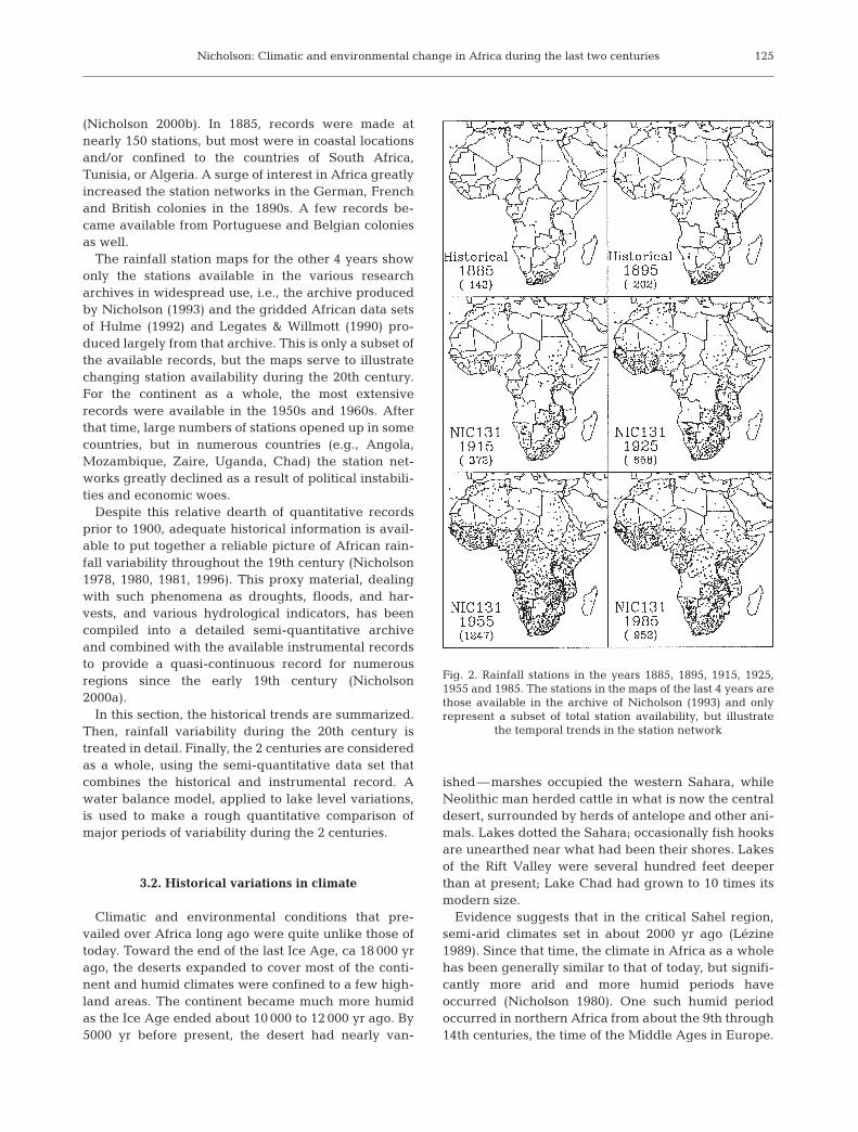
Fig. 2 shows rainfall stations operating in selectyears: 1885, 1895, 1915, 1925, 1955 and 1985. Those forthe first 2 years represent nearly all available records
124
Fig. 1. Mean annual rainfall (mm) over Africa
Nicholson: Climatic and environmental change in Africa during the last two centuries
(Nicholson 2000b). In 1885, records were made atnearly 150 stations, but most were in coastal locationsand/or confined to the countries of South Africa,Tunisia, or Algeria. A surge of interest in Africa greatlyincreased the station networks in the German, Frenchand British colonies in the 1890s. A few records be-came available from Portuguese and Belgian coloniesas well.
The rainfall station maps for the other 4 years showonly the stations available in the various researcharchives in widespread use, i.e., the archive producedby Nicholson (1993) and the gridded African data setsof Hulme (1992) and Legates & Willmott (1990) pro-duced largely from that archive. This is only a subset ofthe available records, but the maps serve to illustratechanging station availability during the 20th century.For the continent as a whole, the most extensiverecords were available in the 1950s and 1960s. Afterthat time, large numbers of stations opened up in somecountries, but in numerous countries (e.g., Angola,Mozambique, Zaire, Uganda, Chad) the station net-works greatly declined as a result of political instabili-ties and economic woes.
Despite this relative dearth of quantitative recordsprior to 1900, adequate historical information is avail-able to put together a reliable picture of African rain-fall variability throughout the 19th century (Nicholson1978, 1980, 1981, 1996). This proxy material, dealingwith such phenomena as droughts, floods, and har-vests, and various hydrological indicators, has beencompiled into a detailed semi-quantitative archiveand combined with the available instrumental recordsto provide a quasi-continuous record for numerousregions since the early 19th century (Nicholson2000a).
In this section, the historical trends are summarized.Then, rainfall variability during the 20th century istreated in detail. Finally, the 2 centuries are consideredas a whole, using the semi-quantitative data set thatcombines the historical and instrumental record. Awater balance model, applied to lake level variations,is used to make a rough quantitative comparison ofmajor periods of variability during the 2 centuries.
3.2. Historical variations in climate
Climatic and environmental conditions that pre-vailed over Africa long ago were quite unlike those oftoday. Toward the end of the last Ice Age, ca 18 000 yrago, the deserts expanded to cover most of the conti-nent and humid climates were confined to a few high-land areas. The continent became much more humidas the Ice Age ended about 10 000 to 12 000 yr ago. By5000 yr before present, the desert had nearly van-
ished—marshes occupied the western Sahara, whileNeolithic man herded cattle in what is now the centraldesert, surrounded by herds of antelope and other ani-mals. Lakes dotted the Sahara; occasionally fish hooksare unearthed near what had been their shores. Lakesof the Rift Valley were several hundred feet deeperthan at present; Lake Chad had grown to 10 times itsmodern size.
Evidence suggests that in the critical Sahel region,semi-arid climates set in about 2000 yr ago (Lézine1989). Since that time, the climate in Africa as a wholehas been generally similar to that of today, but signifi-cantly more arid and more humid periods haveoccurred (Nicholson 1980). One such humid periodoccurred in northern Africa from about the 9th through14th centuries, the time of the Middle Ages in Europe.
125
Fig. 2. Rainfall stations in the years 1885, 1895, 1915, 1925,1955 and 1985. The stations in the maps of the last 4 years arethose available in the archive of Nicholson (1993) and onlyrepresent a subset of total station availability, but illustrate
the temporal trends in the station network
Clim Res 17: 123–144, 2001
Elephants and giraffe roamed and caravans traversedwhat is now waterless desert; towns flourished in partsof the Sahara which are now too dry to support humanoccupation. Major civilizations, such as the Maliempire, thrived along the Sahara’s southern margin inthe present day Sahel.
Reports of settlers and travellers, local histories andgeologic studies of lakes and rivers suggest that in theSahel relatively humid conditions also prevailed fromthe 16th through 18th centuries. Details concerningthat time period are summarized in Nicholson (1996).In the latter half of the period, this was probably truefor other parts of Africa as well. In southern Africa,rushy grasses, swamps, springs, periodical rivers, andsavanna animals occupied now dry regions. LakeNgami in the Kalahari, now completely dry, was deepenough to produce powerful waves that washed hip-pos and fish to shore. At the end of the 18th century,more arid conditions rapidly set in and persistedthrough the first decades of the 19th century, but rela-tively wet conditions again returned in the latter half ofthe century.
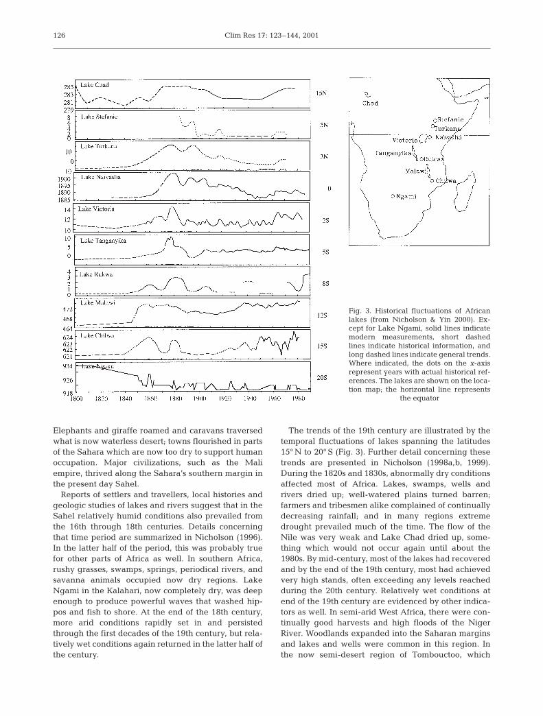
The trends of the 19th century are illustrated by thetemporal fluctuations of lakes spanning the latitudes15° N to 20° S (Fig. 3). Further detail concerning thesetrends are presented in Nicholson (1998a,b, 1999).During the 1820s and 1830s, abnormally dry conditionsaffected most of Africa. Lakes, swamps, wells andrivers dried up; well-watered plains turned barren;farmers and tribesmen alike complained of continuallydecreasing rainfall; and in many regions extremedrought prevailed much of the time. The flow of theNile was very weak and Lake Chad dried up, some-thing which would not occur again until about the1980s. By mid-century, most of the lakes had recoveredand by the end of the 19th century, most had achievedvery high stands, often exceeding any levels reachedduring the 20th century. Relatively wet conditions atend of the 19th century are evidenced by other indica-tors as well. In semi-arid West Africa, there were con-tinually good harvests and high floods of the NigerRiver. Woodlands expanded into the Saharan marginsand lakes and wells were common in this region. Inthe now semi-desert region of Tombouctoo, which
126
Fig. 3. Historical fluctuations of Africanlakes (from Nicholson & Yin 2000). Ex-cept for Lake Ngami, solid lines indicatemodern measurements, short dashedlines indicate historical information, andlong dashed lines indicate general trends.Where indicated, the dots on the x-axisrepresent years with actual historical ref-erences. The lakes are shown on the loca-tion map; the horizontal line represents
the equator

Nicholson: Climatic and environmental change in Africa during the last two centuries
depends on Niger floodwaters for agriculture, wheatwas grown and even exported to surrounding coun-tries.
Another change occurred around 1895, commensu-rate with a decline in rainfall in the global tropics(Kraus 1955). Thus, the 20th century commenced witha period of aridity similar to that 100 yr earlier,although probably much less extreme. This culminatedin severe and widespread droughts primarily in the1910s and there was general concern about the desic-cation of Africa. A drought commission was set up tostudy the problem in southern Africa and to evaluatethe recommendation of a hydrologist, Schwarz (1920),that the Kalahari should be inundated in an attempt tobring back good rainfall to the region. As with thechanges of the 19th century, the anomaly was rela-tively short-lived and ‘good’ rains returned within adecade. These more recent conditions are described inthe following section.
3.3. Rainfall variability during the 20th century
The most comprehensive studies of African rainfallvariability during the 20th century are those of Nichol-son (1993, 1994), Nicholson et al. (2000) and Hulme(1992, 1996). Fig. 4 presents an update of an analysisin Nicholson (1994) and describes the precipitationtrends for several regions of the continent. The loca-tions of these regions are shown in Fig. 5. Because asmall number of spatial modes of variability serves todescribe a large proportion of the overall variance inrainfall, the 11 time series provide a good picture ofrainfall variability over most of Africa.
The relatively dry conditions early in the 20th cen-tury are apparent in most of the time series in Fig. 4.The exceptions are equatorial East Africa and the tem-perate extremes of the North and South ‘Coasts’ ofAfrica (Fig. 4a,b). In West Africa (Fig. 4c), relativelygood conditions had returned during the 1920s and1930s, but relatively dry conditions persisted in muchof southern Africa. Generally drier conditions alsocharacterized the North and South ‘Coasts’ and EastAfrica. In the 1940s, there was again widespreaddrought, particularly in West Africa.
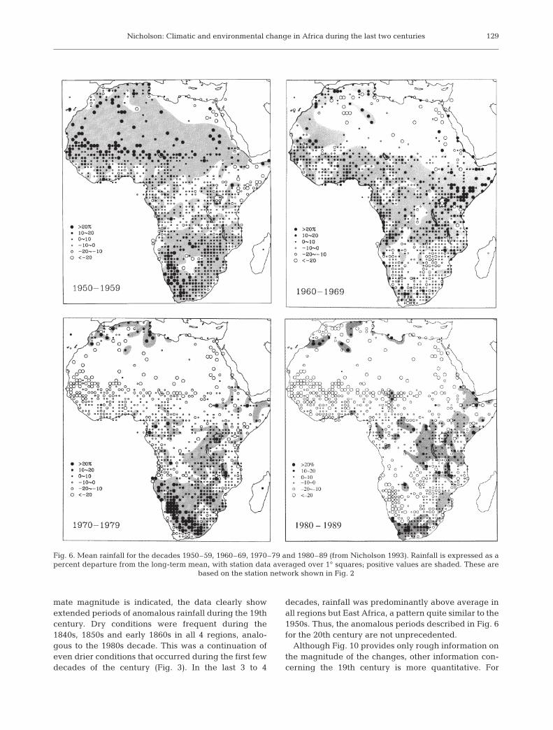
More extreme fluctuations occurred in the latter halfof the 20th century. These are evident in the time se-ries in Fig. 4, but are accentuated with the continental-scale maps of the last 5 decades, presented in Figs 6 &7. The first period of note was the 1950s, when rainfalland river flow increased markedly in the semi-arid re-gions of both northern and southern Africa. For thecontinent as a whole, this was probably the wettest pe-riod since at least the 1870s and 1880s, but a pattern ofsub-normal rainfall prevailed in the equatorial regions.
127
Fig. 4. Rainfall fluctuations 1901 to 1998, expressed as aregionally averaged standard deviation (departure from thelong-term mean divided by the standard deviation). Locationsof the regions are indicated in Fig. 5. (a) North African andSouth African littoral, (b) Equatorial and southern Africa,
(c) West Africa
a
b
c

Clim Res 17: 123–144, 2001
In the early 1960s another dramatic shift occurred,when rainfall increased dramatically throughout mostof the equatorial region. The change was marked byan abrupt increase in the level of Rift Valley lakes,such as Victoria (Farquharson & Sutcliffe 1998, Nichol-son & Yin 2000). The spatial pattern for the 1960s wasroughly the inverse of that for the 1950s: lower rainfallin the subtropical latitudes, reduced rainfall in the lowlatitudes. By the 1970s, increased aridity was wide-spread, especially in the early 1970s (Nicholson 1994),but the decade as a whole was relatively wet in muchof southern Africa, a result of several years of ex-tremely high rainfall in mid-decade. By the 1980s, rain-fall was below the long-term mean over most of Africa,a trend that has continued into the 1990s (Fig. 7).
Fig. 8 quantifies the magnitude of the changes thathave taken place (see Nicholson et al. 2000). A com-parison is made between the relatively wet period1931–60 (long considered a climatological ‘normal’)and the period 1968–97, which coincides with the longperiod of aridity beginning in the late 1960s. The dif-ference between the means for these periods is asmuch as 20 to 40% in Sahelian West Africa and on theorder of 5 to 10% over much of the rest of the conti-nent. In widespread areas of the Sahel, this change isequivalent to 0.4 mm d–1 (Hulme 1996). This is equiva-lent to a ca 1° latitude shift in the rainfall isohyets overWest Africa from June through August (Nicholson etal. 1998) (see Fig. 9). In many areas of equatorial Africa(e.g., the Guinea Coast and western equatorial region),
rainfall increased by over 0.4 mm d–1 in these samemonths.
The magnitude of the rainfall anomalies for the1970s and 1980s is indicated in Table 1, which ex-presses regionally averaged rainfall as a percentdeparture from the long-term mean and as a percentstandard deviation (SD). In the arid regions of WestAfrica, rainfall was about half a SD below the long-term mean in the 1970s, but approximately 0.8 SDs inthe 1980s. The change in the more humid Guineanregions was more moderate but was also greater in the1980s. In East Africa, the averages for the 2 decadeswere 0.04 and 0.15 SDs above normal, respectively. Insouthern Africa, the increase in the 1970s, up to0.56 SDs, was roughly equivalent to the decrease inrainfall in the 1980s. There, rainfall was only about0.21 to 0.27 SDs below the long-term mean during the1980s, thus the change was considerably smaller thanin the Sahel. But the prevailing fact is that rainfall wasbelow normal throughout most of Africa during the1980s, and this pattern has generally prevailedthrough the 1990s.
3.4. Two centuries of rainfall variability
Fig. 10 shows semi-quantitative time series of rainfallsince 1840 for 4 of the regions shown in Fig. 4. Theseare produced by combining proxy indicators of rainfallwith the available instrumental records for the 19thcentury and from instrumental records for the 20thcentury. The details of the methodology are given inNicholson (2000b). Data are assigned to 1 of 7 anomalyclasses, with values ranging from –3 (driest) to +3(wettest) and with 0 being indicative of ‘normal’ condi-tions.
This figure serves to provide some continuity overthe last century and a half. Although only an approxi-
128
Fig. 5. Geographical regions represented by rainfall time series in Fig. 4
1970–79 1980–89% % σ % % σ
Sahelo-Sahara –31 –47 –24 –35Sahel –22 –55 –31 –82Soudan –13 –53 –20 –85Soudano-Guinean Zone –5 –36 –8 –56Guinea Coast –6 –31 –7 –35Eastern Africa 0 4 2 15Southern Africa–North 6 20 –5 –21Southern Africa–South 10 34 –7 –27Southern Africa–West 26 56 –12 –25
Table 1. Rainfall anomalies for the decades 1970–79 and1980–89, expressed as a percent departure from the long-term mean and as a standardized departure (ratio of the
departure from mean to the standard departure)
Nicholson: Climatic and environmental change in Africa during the last two centuries
mate magnitude is indicated, the data clearly showextended periods of anomalous rainfall during the 19thcentury. Dry conditions were frequent during the1840s, 1850s and early 1860s in all 4 regions, analo-gous to the 1980s decade. This was a continuation ofeven drier conditions that occurred during the first fewdecades of the century (Fig. 3). In the last 3 to 4
decades, rainfall was predominantly above average inall regions but East Africa, a pattern quite similar to the1950s. Thus, the anomalous periods described in Fig. 6for the 20th century are not unprecedented.
Although Fig. 10 provides only rough information onthe magnitude of the changes, other information con-cerning the 19th century is more quantitative. For
129
Fig. 6. Mean rainfall for the decades 1950–59, 1960–69, 1970–79 and 1980–89 (from Nicholson 1993). Rainfall is expressed as apercent departure from the long-term mean, with station data averaged over 1° squares; positive values are shaded. These are
based on the station network shown in Fig. 2

Clim Res 17: 123–144, 2001
example, Grove (1972) showed that the Nile dischargeduring the period ca 1880–95 was about 35% greaterthan for the period 1910–40. Rainfall at Freetown,Sierra Leone, declined by a comparable amount duringthe same period (Nicholson 1981). Shaw (1985) calcu-lated that the 19th century high stands of Lake Ngamirequired that it receive about 11% of the Okavango’scurrent total inflow, implying a rainfall increase ofabout the same order of magnitude.
Nicholson & Yin (2000) also produced estimates ofthe magnitude of change in the equatorial region,based on the levels of Lake Victoria (Fig. 11). Theapparent desiccation of Victoria and other lakes earlyin the century could have resulted from rainfall duringthe period 1785 to 1835 that was only 12% below themodern mean. This calculation assumes no change ofcloudiness. With a small change in cloud cover increas-ing the incoming solar radiation, a smaller change inrainfall would have been required to account for thelake level fluctuations. The high stands attained in the1870s could similarly have been achieved with rainfallonly 10% above the modern mean, but sustained forthe period 1858 to 1878. Anomalies of this magnitudeare not unusual today, but the result of sustainedanomalies was relatively extreme changes in the phys-ical environment of Africa.
4. PROCESSES OF CHANGE
Since the well-publicized drought of the 1960s and1970s in the Sahel, numerous theories have been putforth to explain the occurrence of this drought andother climatic anomalies throughout Africa. Some ofthese have been strictly meteorological and/or linkedto the global oceans; others have emphasized feed-back processes associated with land surface changesthat may have been coupled with the meteorologicalchanges or independently produced through humanactivities. In this section, some of the most popularideas are summarized and evaluated.
Clearly, there are common factors that influencemost of the continent. The rainfall anomaly patterns ofindividual years and of decades tend to be continentalin scale (Fig. 6). Recent work has shown, for example,that anomalously cold conditions over the Atlantic andIndian Ocean regions surrounding the continent tendto increase rainfall over Africa as a whole, while anom-alously warm conditions tend to reduce it (Nicholson1997). However, there are extensive regional differ-ences in the nature of rainfall variability and in thedegree of control of regional- versus global-scale fac-tors.
For this reason, our current understanding of theprocesses of change is summarized separately for WestAfrica and for the semi-arid regions of East and south-ern Africa. The temperate extremes, with predomi-
130
Fig. 7. Mean rainfall for the 8 yr period 1990–97 (from Nichol-son et al. 2000). Rainfall is expressed as a percent departurefrom the long-term mean, with station data averaged over
1° squares; positive values are shaded
Fig. 8. Difference (in %) between mean annual rainfall during 1931–60 and 1968–97 (from Nicholson et al. 2000)
Nicholson: Climatic and environmental change in Africa during the last two centuries
nantly cold-season rainfall, are not considered, as rain-fall there responds mostly to mid-latitude changes thatare described in more detail elsewhere (e.g., Bradleyet al. 1987). Likewise, the central equatorial region isnot considered, as the meteorological processes gov-erning variability there are not well understood.
There are several reasons for a separate discussionof processes over West Africa. For one, the nature of
rainfall variability is quite different there. In theSahel-Soudan region of West Africa, much of thevariance is concentrated on decadal time scales andthere is a strong year-to-year persistence of anom-alous conditions over much of the region. This impliesa somewhat different set of controls on this regioncompared to others, where global-scale phenomenasuch as the El Niño/Southern Oscillation (ENSO)have a dominant influence. Also, the meteorologicalaspects of rainfall variability have been much moreintensively studied over West Africa. Finally, there isa considerable body of knowledge that suggests thatfeedback between the land and atmosphere may playa significant role in the semi-arid regions of WestAfrica. These feedback processes are treated in Sec-tion 4.2.
4.1. Atmospheric and oceanic processes
4.1.1. West Africa
Over the last 20 yr our understanding of the factorswhich govern the interannual variability of rainfall inWest Africa has increased substantially. The earliesthypotheses concerning the cause of the Sahel droughtwere largely confined to the latitudinal displacement
131
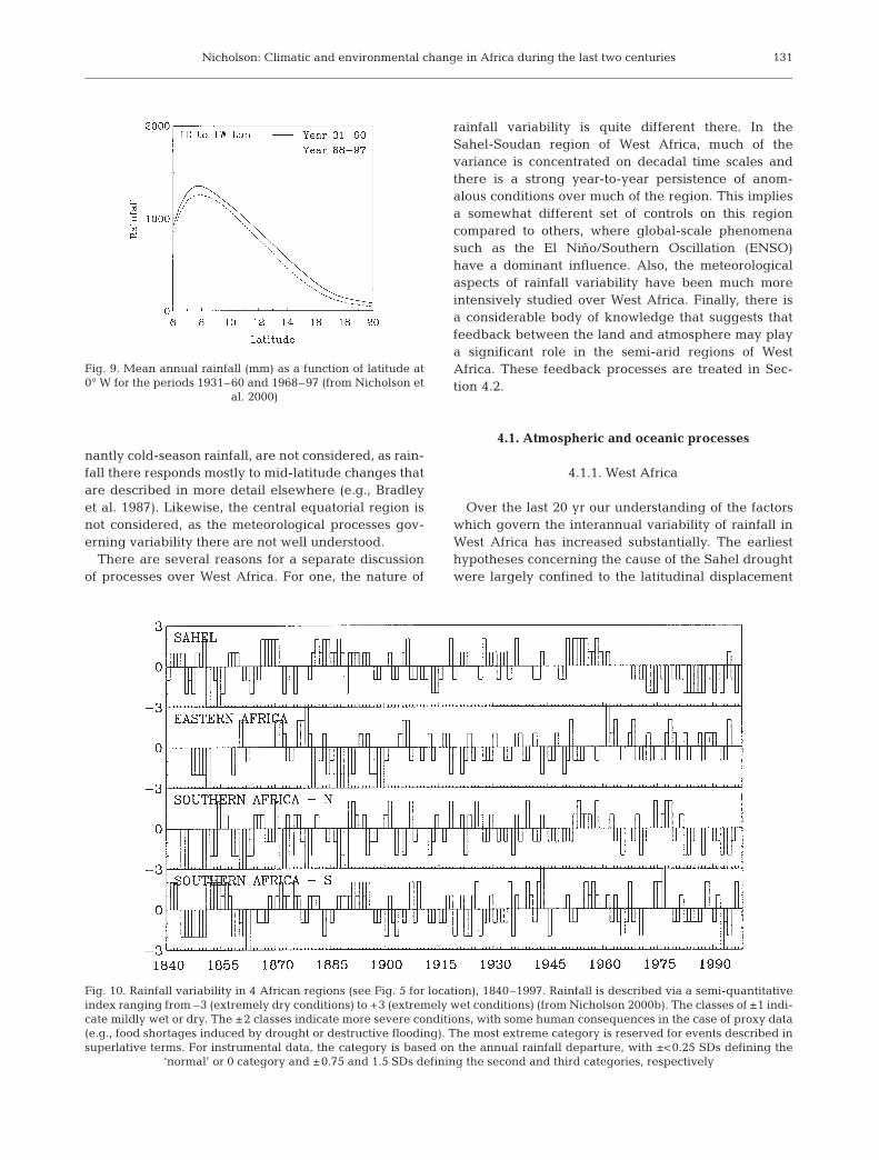
Fig. 9. Mean annual rainfall (mm) as a function of latitude at0° W for the periods 1931–60 and 1968–97 (from Nicholson et
al. 2000)
Fig. 10. Rainfall variability in 4 African regions (see Fig. 5 for location), 1840–1997. Rainfall is described via a semi-quantitativeindex ranging from –3 (extremely dry conditions) to +3 (extremely wet conditions) (from Nicholson 2000b). The classes of ±1 indi-cate mildly wet or dry. The ±2 classes indicate more severe conditions, with some human consequences in the case of proxy data(e.g., food shortages induced by drought or destructive flooding). The most extreme category is reserved for events described insuperlative terms. For instrumental data, the category is based on the annual rainfall departure, with ±<0.25 SDs defining the
‘normal’ or 0 category and ±0.75 and 1.5 SDs defining the second and third categories, respectively

Clim Res 17: 123–144, 2001
of the ITCZ, often in response to latitudinal shifts in themid-latitude pressure zones. The current picture is onein which large-scale changes of sea-surface tempera-ture (SST) patterns promote changes in several majoratmospheric circulations that influence West Africa(Lamb 1978, Hastenrath 1990, Folland et al. 1991,Lamb & Peppler 1992, Wagner & da Silva 1994, Ward1998). Notable among these is the African Easterly Jet(AEJ), a feature that helps to generate and maintainthe wave disturbances that modulate the rainfall fieldin the region.
In general, the ‘wet’ years in the Sahel tend to becharacterized by a pattern of SSTs in which the tropicalAtlantic is anomalously warm, compared to dry years,while anomalously cold SSTs prevail to the west of thecontinent. In the dry years, the AEJ is generallystronger than in the wet years and is displaced equa-torward, while the Tropical Easterly Jet is unusuallyweak. The ITCZ is often likewise displaced furthersouth and/or abnormally weak. Important changeshave also been noted in atmospheric moisture flux anddivergence fields over the continent and in the natureof the convective disturbances affecting the region.
The issues that are least understood are the directrelationships between the characteristic changes overthe ocean and those in the circulation features over thecontinent, the relationship between the wave activityassociated with the jet and the convective disturbancesthat bring most of the region’s rainfall, and the influ-ence of the ENSO on rainfall over West Africa. TheENSO phenomenon has been shown to have a decisiveinfluence on rainfall in some regions, most notably theGuinea Coast, where it tends to enhance rainfall. Itsinfluence in the Sahel has been disputed, with somestudies noting a tendency for the ENSO to be associ-ated with reduced rainfall and others concluding thatthere is little consistent influence in the region. Themost notable study is that of Ward (1998), which sug-gests that its influence is primarily on higher frequencyfluctuations (i.e., on individual years rather than thedecadal-scale wet and dry intervals). Ward (1998) also
132
Fig. 11. Fluctuations of Lake Victoria since 1780. Years forwhich specific references are available are indicated at thebottom with dots. Levels since 1896 are based on modernmeasurements and earlier years are reconstructed from his-torical references. Dashed line indicates period for which onlygeneral trends, not data for specific years, can be ascertained
Fig. 12. ENSO-composite rainfall anom-alies for 15 African sectors (see map forlocations) (from Nicholson & Kim 1997).Time series commence in July in the yearprior to the ENSO and continue to June ofthe year following it. Shadings indicate‘seasons’ of possible ENSO-related rain-fall response, with dark shading indicat-ing seasons of maximum negative rainfallanomalies and light shading indicatingseasons of maximum positive rainfallanomalies. Amplitude is an index basedon rank. (a) North and West African sec-tors; (b) western sectors of equatorial andsouthern Africa; (c) eastern sectors of
equatorial and southern Africa
a b
c

Nicholson: Climatic and environmental change in Africa during the last two centuries
notes that the influence of the ENSO appears to begreater during relatively dry intervals than during rel-atively wet ones, suggesting greater coupling of theregion to global atmospheric processes during a ‘dry’mode.
4.1.2. Eastern and southern Africa
Eastern and southern Africa are regions of mainlysemi-arid and subhumid climates with a pronounceddry season during at least part of the year. In contrastto West Africa, the variability of rainfall is concentratedon relatively short time scales. The primary ones areroughly 2.3, 3.5 and 5 yr, the same time scales thatdominate the ENSO phenomenon and global SST vari-ability (Nicholson 1989). This suggests a direct connec-tion between rainfall variability in these regions andglobal processes.
Throughout these regions, there is a strong ENSOsignal in rainfall variability (Fig. 12). Rainfall tends tobe enhanced in East Africa toward the end of theENSO year and early in the following year. It tends tobe reduced in southern Africa at this same time, partic-ularly in the months of February through May of theyear following the ENSO. The opposite pattern tendsto prevail, but less consistently so, in the year preced-ing the ENSO and in the cold La Niña (Fig. 13).
An examination of SST patterns during these eventsshows a somewhat different picture. The anticipatedENSO signals materialize when a specific pattern ofSSTs develops, in conjunction with the ENSO, in the
Atlantic and Indian Ocean regions surrounding Africa.Such patterns develop in roughly 3 of every 4 ENSOevents (Nicholson 1997). Thus, the factor of primaryimportance is the SSTs in proximity to Africa, ratherthan the ENSO itself. In this context, specific regionsmay be particularly important. The eastern Atlanticand parts of the western Indian Ocean, for example,influence rainfall over much of equatorial and southernAfrica (Nicholson & Entekhabi 1986, Hastenrath et al.1993, 1995, Mason et al. 1994, Mason 1995, Rocha &Simmonds 1996).
4.2. Land surface effects
4.2.1. General
The highly populated West African Sahel has histor-ically been prone to long and severe droughts. Com-mensurate with the drought of the 1960s and early1970s arose the idea that the region was also undergo-ing a long-term process of desertification, which mayhave exacerbated or even caused the drought andmost certainly enhanced its impact. Charney’s (1975)classic paper on the Sahel, for example, speculatedthat albedo changes related to overgrazing and denud-ing of the highly reflective soil may have contributedto, or even been responsible for, the drought. This sec-tion examines some of the key, related issues: theconcept of desertification, long-term albedo changes,atmospheric dust loading, and general hydrologicfeedbacks to the atmosphere.
133
Fig. 13. La Niña-composite rainfallanomalies for 6 African sectors (see mapfor location) (from Nicholson & Selato2000). Time series commence in July inthe year prior to La Niña and continue toJune of the year following it. Shadingsindicate ‘seasons’ of possible La Niña-related rainfall response. Amplitude isan index based on rank. (a) North andWest African sectors; (b) western sectorsof equatorial and southern Africa; (c) eastern sectors of equatorial and
southern Africa
a b
c
Clim Res 17: 123–144, 2001
4.2.2. Desertification
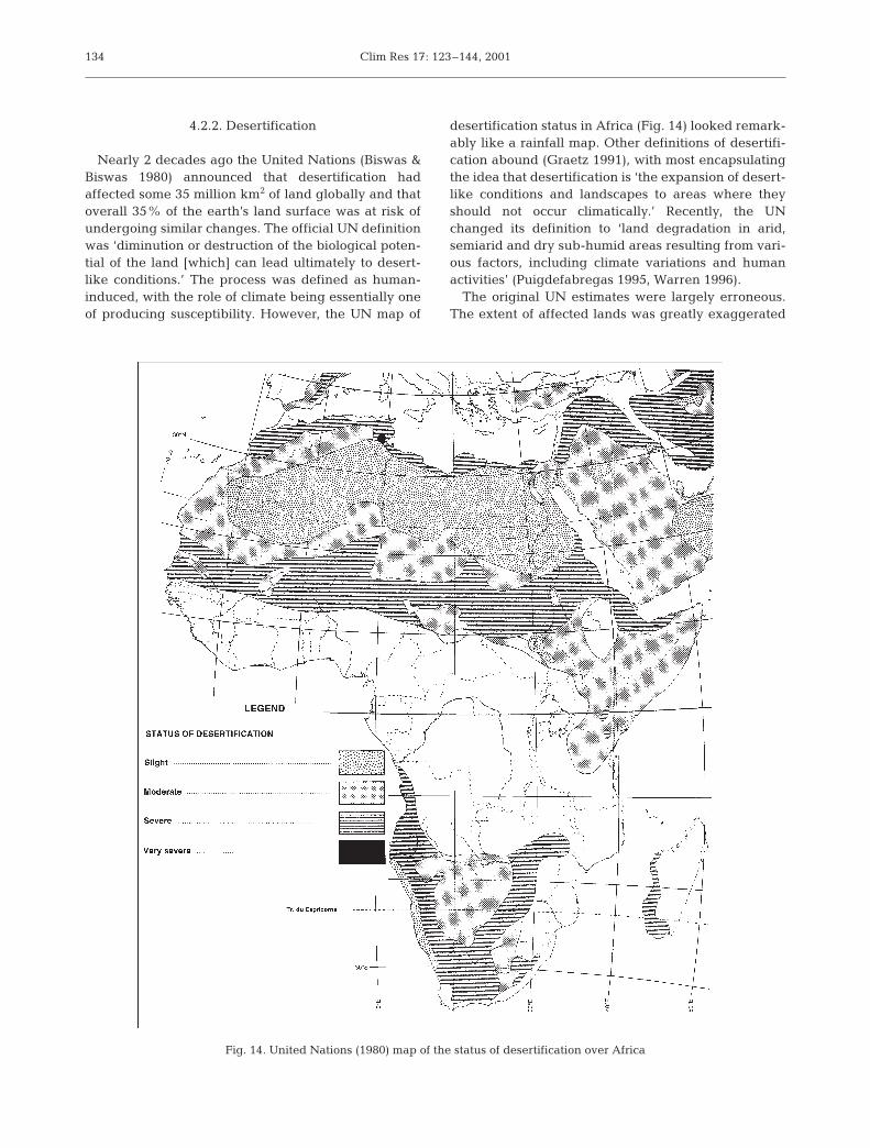
Nearly 2 decades ago the United Nations (Biswas &Biswas 1980) announced that desertification hadaffected some 35 million km2 of land globally and thatoverall 35% of the earth’s land surface was at risk ofundergoing similar changes. The official UN definitionwas ‘diminution or destruction of the biological poten-tial of the land [which] can lead ultimately to desert-like conditions.’ The process was defined as human-induced, with the role of climate being essentially oneof producing susceptibility. However, the UN map of
desertification status in Africa (Fig. 14) looked remark-ably like a rainfall map. Other definitions of desertifi-cation abound (Graetz 1991), with most encapsulatingthe idea that desertification is ‘the expansion of desert-like conditions and landscapes to areas where theyshould not occur climatically.’ Recently, the UNchanged its definition to ‘land degradation in arid,semiarid and dry sub-humid areas resulting from vari-ous factors, including climate variations and humanactivities’ (Puigdefabregas 1995, Warren 1996).
The original UN estimates were largely erroneous.The extent of affected lands was greatly exaggerated
134
Fig. 14. United Nations (1980) map of the status of desertification over Africa
Nicholson: Climatic and environmental change in Africa during the last two centuries
and the issue of desertification has become a contro-versial one, suffering from a dearth of data and rigor-ous scientific study (see Verstraete 1986, Graetz 1991,Hellden 1991, Mainguet 1991, Thomas & Middleton1994). Desertification estimates for Africa, in particu-lar, were problematic for 2 reasons (Nicholson et al.1998). For one, the information was largely anecdotal.Secondly, the few actual assessments extended overperiods of drought or rainfall decline. A prime exampleis the so-called ‘advance of the desert’ into the Sahel.This concept was based on 2 assessments of the geo-graphical limits of the Acacia tree in the Sudan. Usingmaps from the 1950s and aerial surveys from 1975for this assessment, Lamprey (1975) concluded thatbetween 1958 to 1975 the desert had advanced south-ward in the western Sudan by 90 to 100 km. Duringthis same period, rainfall in the Sahel declined bynearly 50%, with a somewhat lesser reduction in thewestern Sudan (Nicholson 1990). Thus, while desertifi-cation itself was defined as anthropogenic, the evi-dence used to assess it could equally have been a prod-uct of climatic variability. This is true of many otherinstances of supposed widespread desertification inareas of the United States, Australia and elsewhere(Nicholson et al. 1998).
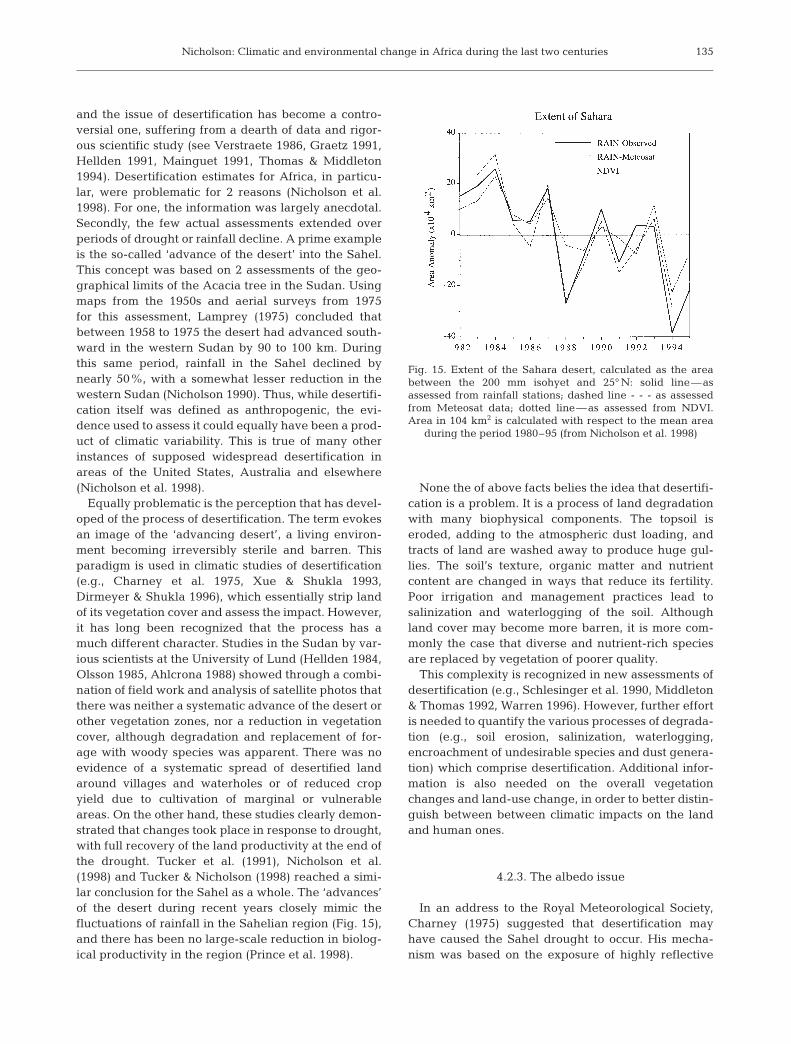
Equally problematic is the perception that has devel-oped of the process of desertification. The term evokesan image of the ‘advancing desert’, a living environ-ment becoming irreversibly sterile and barren. Thisparadigm is used in climatic studies of desertification(e.g., Charney et al. 1975, Xue & Shukla 1993,Dirmeyer & Shukla 1996), which essentially strip landof its vegetation cover and assess the impact. However,it has long been recognized that the process has amuch different character. Studies in the Sudan by var-ious scientists at the University of Lund (Hellden 1984,Olsson 1985, Ahlcrona 1988) showed through a combi-nation of field work and analysis of satellite photos thatthere was neither a systematic advance of the desert orother vegetation zones, nor a reduction in vegetationcover, although degradation and replacement of for-age with woody species was apparent. There was noevidence of a systematic spread of desertified landaround villages and waterholes or of reduced cropyield due to cultivation of marginal or vulnerableareas. On the other hand, these studies clearly demon-strated that changes took place in response to drought,with full recovery of the land productivity at the end ofthe drought. Tucker et al. (1991), Nicholson et al.(1998) and Tucker & Nicholson (1998) reached a simi-lar conclusion for the Sahel as a whole. The ‘advances’of the desert during recent years closely mimic thefluctuations of rainfall in the Sahelian region (Fig. 15),and there has been no large-scale reduction in biolog-ical productivity in the region (Prince et al. 1998).
None the of above facts belies the idea that desertifi-cation is a problem. It is a process of land degradationwith many biophysical components. The topsoil iseroded, adding to the atmospheric dust loading, andtracts of land are washed away to produce huge gul-lies. The soil’s texture, organic matter and nutrientcontent are changed in ways that reduce its fertility.Poor irrigation and management practices lead tosalinization and waterlogging of the soil. Althoughland cover may become more barren, it is more com-monly the case that diverse and nutrient-rich speciesare replaced by vegetation of poorer quality.
This complexity is recognized in new assessments ofdesertification (e.g., Schlesinger et al. 1990, Middleton& Thomas 1992, Warren 1996). However, further effortis needed to quantify the various processes of degrada-tion (e.g., soil erosion, salinization, waterlogging,encroachment of undesirable species and dust genera-tion) which comprise desertification. Additional infor-mation is also needed on the overall vegetationchanges and land-use change, in order to better distin-guish between between climatic impacts on the landand human ones.
4.2.3. The albedo issue
In an address to the Royal Meteorological Society,Charney (1975) suggested that desertification mayhave caused the Sahel drought to occur. His mecha-nism was based on the exposure of highly reflective
135
Fig. 15. Extent of the Sahara desert, calculated as the areabetween the 200 mm isohyet and 25° N: solid line—asassessed from rainfall stations; dashed line - - - as assessedfrom Meteosat data; dotted line—as assessed from NDVI.Area in 104 km2 is calculated with respect to the mean area
during the period 1980–95 (from Nicholson et al. 1998)

Clim Res 17: 123–144, 2001
soil as a result of overgrazing, a hypothesis also putforth by Otterman (1974). Using a simple dynamicmodel, Charney showed that such an increase in sur-face albedo would increase radiative losses over theSahara, thereby enhancing the negative net radiationbalance of the desert and adjacent Sahel. These resultssuggested a positive feedback mechanism by whichdroughts could be self-accelerating, or could perhapseven be produced. This paper was followed up by sev-eral general circulation model (GCM) experiments thatdrew conclusions consistent with Charney’s originalhypothesis (e.g., Charney et al. 1975, 1977, Sud & Fen-nessy 1982, Sud & Molod 1988, Xue & Shukla 1993,Dirmeyer & Shukla 1994, 1996, Lofgren 1995a,b).
The various model simulations are in general agree-ment that, if a very large change in surface albedo isinduced in semi-arid regions such as the Sahel, aregionally significant decrease in rainfall should result.The question that has not been adequately addressedis the extent to which such albedo changes have takenplace. Few measurements have been carried out, but 3case studies are worth noting: a study of ‘protected’and ‘unprotected’ grazing areas in Tunisia and studiesthat surveyed grazed and ungrazed sides of interna-tional borders in the Sinai/Negev and the SonoranDesert of the US and Mexico. Satellite photos (Otter-man 1977, 1981) indicate that the soil in the overgrazedSinai has an albedo of 0.4 in the visible and 0.53 in theinfrared; in the protected area of the Negev, the visibleand infrared albedos were 0.12 and 0.24 respectively,but in most of the region the albedo averaged about0.25. In Tunisia the albedo of protected versus unpro-tected sites was 0.35 versus 0.39 in one case and 0.26versus 0.36 in another, while oases had albedos on theorder of 0.10 to 0.23 (Wendler & Eaton 1983).
These changes are roughly of the same order ofmagnitude as the albedo changes in the Charney mod-els. However, they are quite small in spatial scale. Thefew large-scale studies conducted over Africa havesuggested a different picture. Early studies of Nortonet al. (1979) and Courel et al. (1984) showed that inthe southern Sahel, albedo progressively increasedbetween 1967 (a ‘normal’ year) and 1973 (the worstdrought year) by ~20% during the dry season (0.29 to0.34) and by ~50% during the wet season (0.23 to 0.33).However from 1973 to 1979, i.e., after the droughtended, albedo decreased by 20 to 60% in the Sahel.Thus, the change in albedo was neither permanent norprogressive and tended to follow the changing rainfallpatterns, a conclusion drawn also by Olsson (1985) forareas of the Sudanese Sahel further east. Nicholson etal. (1998) added a few additional years of study to thealbedo question, examining the extreme dry years1983 and 1984, plus the wetter years 1985 to 1988. Thisstudy provided further evidence of the link between
rainfall and surface albedo and the lack of a progres-sive increase in albedo. This study also found that thetotal year-to-year albedo variation during the analysisperiod was about half as great as the albedo changebetween the wet and dry seasons.
Unfortunately, all of the above estimates of surfacealbedo have been within a relatively dry period. Anincrease in albedo on a large scale between the sus-tained wetter interval in the Sahel during and prior tothe 1950s and the subsequent 3 dry decades cannot beruled out. However, there are clear constraints on thepossible degree of change. Gornitz (1985) examinedthe potential effects of land-use change throughoutWest Africa over the course of the century and foundthat the documented changes would have had minimalinfluence on surface albedo. Ba et al. (2000) alsodemonstrated that the overall surface albedo is largelyconstrained by the overall character of the surface veg-etation, including the presence or absence of borealelements and their density. The overall vegetationcharacter does not change on time scales of years, butthere is considerable evidence that it has changed overtime scales of decades in large parts of the Sahel (e.g.,Akhtar-Schuster 1995). Ba et al. also showed that adecrease in vegetation density can actually decreasesurface albedo, as the number of geometric elementsreflecting the light is lower. This is the case in thewoodlands.
Several conclusions can be made, based on theseearlier studies. For one, no large-scale increase in sur-face albedo has been demonstrated over Africa, but asignificant change in the relatively narrow Sahel zonesince the 1950s is conceivable. In view of this possi-bility, the albedo issue merits further examination.Finally, the issue is a complex one and the assumed increase in surface albedo with reduced vegetationcover is not realistic. A better assessment requiresmore realistic consideration of the influence of vegeta-tion on surface albedo and better documentation oflong-term vegetation changes in the region.
4.2.4. Dust
There have been relatively few measurements ofaerosols over Sahelian West Africa. Five studies(Oluwafemi 1979, ben Mohamed & Frangi 1983, 1986,Fouquart et al. 1987a, Faizoun et al. 1994, Pinker et al.1994) have used sun photometers to make measure-ments at a single station. Studies by Cerf (1980), Hol-ben et al. (1991), d’Almeida (1986, 1987), ben Mo-hamed et al. (1992) and Faizoun et al. (1994) have somedegree of spatial coverage, varying from 2 to 11 sta-tions. In some cases, measurements are limited to a fewmonths; many cover a 1 or 2 yr period at each station.
136

Nicholson: Climatic and environmental change in Africa during the last two centuries
All of these studies have demonstrated a high tem-poral and spatial variability of both optical thicknessand aerosol properties, as well as a pronounced sea-sonal cycle. However, they are inadequate for examin-ing long-term trends in dust over West Africa. Recentlydeveloped satellite methodologies will facilitate suchlong-term monitoring. A radiatively equivalent opticalthickness can be obtained over ocean areas usingNOAA AVHRR data (Husar et al. 1997). The TOMSinstrument (Tropospheric Ozone Monitoring System) isalso being utilized to provide estimates of optical thick-ness over land of scattering aerosols.
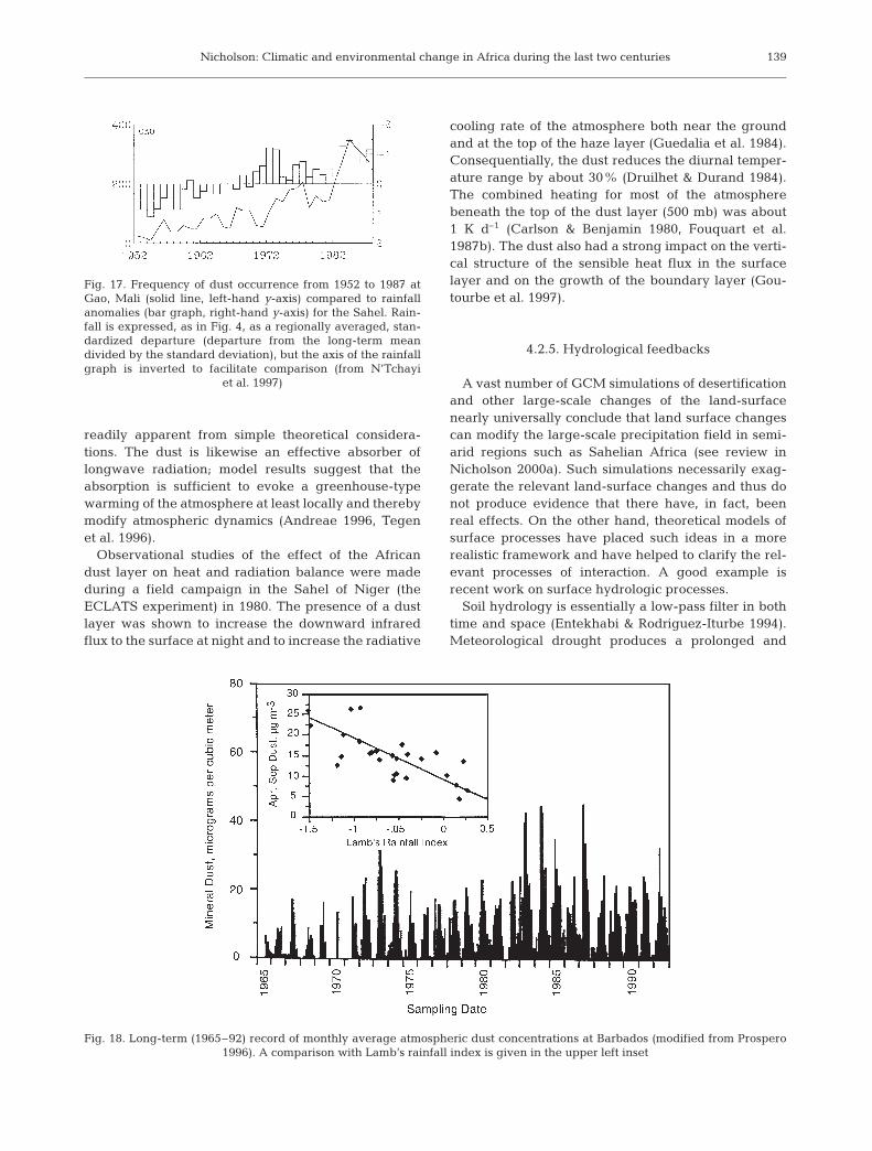
Fortunately, atmospheric visibility is related to dustconcentration, and visibility data have been useful toexamine the spatial and temporal distribution of dustin the region over multi-year periods (N’TchayiMbourou et al. 1994, 1997). The latter study examinedthe spatial distribution of dust by season throughoutWest Africa for the 3 periods 1957–61, 1970–74 and1983–87 (Fig. 16) and long-term trends since 1957 atindividual stations (e.g., Fig. 17). From these analyses,it is apparent that (1) there has been a steady increasein the frequency of occurrence of dust conditions at thesurface over West Africa since the early 1970s, (2) thatit has paralleled a downward trend in rainfall, and(3) that the length of the season with dusty conditionshas continually increased. The implication of this studyis that there has been a steady build-up of dust overWest Africa since the early 1970s. This is confirmed bya consistent upward trend in African dust measured atsites downstream (Prospero & Nees 1986).
West Africa is the source of nearly half of the mineralaerosols residing in the atmosphere (Andreae 1995,Duce 1995). Commonly termed ‘Saharan dust’ or‘desert dust’, it was long assumed to originate in theSahara. Recent evidence suggests instead that most ofit originates in the semi-arid Sahel-Soudan region(e.g., Prospero & Nees 1986, Prospero 1996, N’TchayiMbourou et al. 1997). This evidence includes theexcellent inverse correlation (Fig. 18) between Sahelrainfall and dust transport across the tropical northAtlantic and the seasonal displacement of the ‘Saha-ran’ dust plume, moving some 10° latitude southwardin winter (Prospero & Nees 1986, Prospero et al. 1993,Prospero 1996). Air mass trajectories and the composi-tion of particles point to the Sahel as a source of dustoutbreaks in the Canary Islands (Bergametti et al.1989). Also, in North Africa and elsewhere the build-up of dust is better correlated with Sahelian rainfallthan with local conditions (N’Tchayi Mbourou et al.1997).
The impact of the dust build-up on meteorologicalprocesses over West Africa is not adequately known,but several recent studies suggest that its effect couldbe quite significant. GCM modelling studies have
shown that regional climate cannot be realistically sim-ulated without introducing the dust mobilization in themodel. For example, Tegen & Fung (1994), using theGISS GCM with an aerosol tracer and ‘natural’ condi-tions of soil and vegetation over West Africa, showed aseasonally invariant dust plume of Saharan origin.When the model allowed for ‘disturbed’ soils in theSahel as a result of the long series of recent droughtyears and changes in land management practices, amore realistic, seasonally migrating plume resulted(Tegen & Fung 1995). In fact, the study suggested that‘disturbed’ sources resulting from climate variability,cultivation, deforestation and wind erosion contributesome 30 to 50% of the total atmospheric dust loadingand associated radiative forcing.
Models of convection and wave development haveshown that the dust has an impact on synoptic condi-tions and, therefore, presumably on rainfall as well.Using a mesoscale model and doing case study simula-tions of 2 dust outbreaks, Karyampudi & Carlson (1988)concluded that the layer is important for the mainte-nance and possible growth of some wave disturbancesand that it acts to strengthen the mid-level AEJ. Chang(1993) examined the effect of the dust indirectly bycontrasting the influence of the thermal states of theatmosphere over the Sahara north of the AEJ (i.e., inthe dust layer) and in the wetter region to the south ofthe jet. The thermal structure associated with the dustlayer altered the stability mechanisms and energy con-version processes important in generating waves fromthe jet, and it also altered wave characteristics such asgrowth rate and wavelength.
The impact of African dust on atmospheric heating isquite complex because it modifies both the shortwavesolar radiation transmitted through to the surface andthe longwave infrared radiation emitted to space. Itwas long assumed that the African dust would have lit-tle impact on large-scale climate because of low lightscattering efficiency and low concentrations. However,Li et al. (1996) have shown that, although the massscattering efficiency of this mineral dust is only one-quarter that of non-seasalt sulphate, its annual meanconcentration over the North Atlantic its 16 times asgreat.
The dust both scatters and absorbs solar radiation,but the scattering effect dominates in the visible por-tion of the spectrum (Li et al. 1996, Tegen et al. 1996).Andreae (1996) suggests this would imply a net cool-ing effect in the visible portion of the spectrum, butTegen et al. (1996) conclude that either a cooling orheating effect can occur, depending on cloud coverand on the albedo of the underlying surface. TheAfrican dust also absorbs shortwave radiation andabsorbs and emits infrared radiation; hence its preciseeffect on the thermal structure of the atmosphere is not
137

Clim Res 17: 123–144, 2001138
Fig
. 16.
Map
s of
sea
son
al m
ean
s of
du
st f
req
uen
cy o
ver
Wes
t A
fric
a fo
r th
e ye
ars
1957
–61
, 197
0–
74, a
nd
198
3–
87. T
he
area
of
each
cir
cle
is p
rop
orti
onal
to
the
nu
mb
er o
fh
ours
wit
h v
isib
ilit
y re
du
ced
to
less
th
an 5
km
bec
ause
of
win
d-b
orn
e d
ust
; n
um
ber
s co
rres
pon
d t
o st
atio
ns
(fro
m N
’Tch
ayi
Mb
ouro
u e
t al
. 19
97).
Top
: Ja
nu
ary
to M
arch
(s
easo
n o
f m
axim
um
du
st f
req
uen
cy).
Bot
tom
: Ju
ly t
o S
epte
mb
er (
seas
on o
f m
inim
um
du
st f
req
uen
cy)
Nicholson: Climatic and environmental change in Africa during the last two centuries
readily apparent from simple theoretical considera-tions. The dust is likewise an effective absorber oflongwave radiation; model results suggest that theabsorption is sufficient to evoke a greenhouse-typewarming of the atmosphere at least locally and therebymodify atmospheric dynamics (Andreae 1996, Tegenet al. 1996).
Observational studies of the effect of the Africandust layer on heat and radiation balance were madeduring a field campaign in the Sahel of Niger (theECLATS experiment) in 1980. The presence of a dustlayer was shown to increase the downward infraredflux to the surface at night and to increase the radiative
cooling rate of the atmosphere both near the groundand at the top of the haze layer (Guedalia et al. 1984).Consequentially, the dust reduces the diurnal temper-ature range by about 30% (Druilhet & Durand 1984).The combined heating for most of the atmospherebeneath the top of the dust layer (500 mb) was about1 K d–1 (Carlson & Benjamin 1980, Fouquart et al.1987b). The dust also had a strong impact on the verti-cal structure of the sensible heat flux in the surfacelayer and on the growth of the boundary layer (Gou-tourbe et al. 1997).
4.2.5. Hydrological feedbacks
A vast number of GCM simulations of desertificationand other large-scale changes of the land-surfacenearly universally conclude that land surface changescan modify the large-scale precipitation field in semi-arid regions such as Sahelian Africa (see review inNicholson 2000a). Such simulations necessarily exag-gerate the relevant land-surface changes and thus donot produce evidence that there have, in fact, beenreal effects. On the other hand, theoretical models ofsurface processes have placed such ideas in a morerealistic framework and have helped to clarify the rel-evant processes of interaction. A good example isrecent work on surface hydrologic processes.
Soil hydrology is essentially a low-pass filter in bothtime and space (Entekhabi & Rodriguez-Iturbe 1994).Meteorological drought produces a prolonged and
139
Fig. 17. Frequency of dust occurrence from 1952 to 1987 atGao, Mali (solid line, left-hand y-axis) compared to rainfallanomalies (bar graph, right-hand y-axis) for the Sahel. Rain-fall is expressed, as in Fig. 4, as a regionally averaged, stan-dardized departure (departure from the long-term meandivided by the standard deviation), but the axis of the rainfallgraph is inverted to facilitate comparison (from N’Tchayi
et al. 1997)
Fig. 18. Long-term (1965–92) record of monthly average atmospheric dust concentrations at Barbados (modified from Prospero 1996). A comparison with Lamb’s rainfall index is given in the upper left inset
Clim Res 17: 123–144, 2001
delayed hydrologic drought that creates potential forfurther feedback to the atmosphere on longer timescales and larger space scales. One consequence ofthe various feedbacks involved is a bi-modal state ofclimate in semi-arid regions, in which the systemlocks into a drought mode and persists there for sev-eral years then slips into a persistent wet mode(Rodriguez-Iturbe et al. 1991, Entekhabi et al. 1992).Brubaker & Entekhabi (1994) used a simple analyticalmodel to quantify the magnitude of the feedback pro-cesses associated with the interaction between sur-face heat and moisture fluxes and the atmosphericboundary layer. They found that the feedback pro-cesses are positive for both wet and dry initial anom-alies, but recovery from the dry state is slower thanfrom the wet state because of the switch in the latterfrom soil to atmospheric control (Brubaker & Ente-khabi 1996). This is likewise consistent with observa-tions of rainfall variability in the Sahel and in theGreat Plains (Nicholson 1988, 2000a). Moreover, themagnitude of changes of surface fluxes in the Sahelduring dry and wet years is sufficiently large to alterthe atmospheric thermal and wind structure (Lare &Nicholson 1994).
Some of the most interesting hydrologic results arethose of Koster & Suarez (1996), Scott et al. (1995,1997), and Delworth & Manabe (1993). Koster &Suarez (1996) controlled the time scale of soil moistureretention in a GCM and found that there is greaterdaily precipitation variability with shorter time scalesof retention. They further utilized a statistical model toexplain the feedback. Scott et al. (1997) studied timescales of evapotranspiration response, showing thatthere is a slower response when the GCM is coupled toa bucket model than to a SVAT (soil-atmosphere trans-fer scheme) model. Each evaporative component(interception, soil evaporation, transpiration) has itsown characteristic time scale. This is consistent withthe results of Scott et al. (1995), demonstrating that thecanopy interception reservoir reduces the persistenceof precipitation and evaporation, in that it ‘short cir-cuits’ the land surface hydrology. Delworth & Manabe(1993) also examined time scales of soil moisture reten-tion, showing that they correspond to a first-orderMarkov process with a decay time scale being equal tothe ratio of field capacity to potential evapotranspira-tion. This result, which they had previously obtained ina theoretical study, was also demonstrated with obser-vations.
The implications of these theoretical results are thatmodification of land-surface characteristics can proba-bly alter weather patterns. Much research in the GreatPlains has shown that this is unequivocally true onsmall scales (e.g., Barnston & Schickedanz 1984). Else-where observational evidence of land-atmosphere
feedback processes has been more difficult to estab-lish. In this context, the Hydrologic-Atmospheric PilotExperiment (HAPEX) that took place in SahelianAfrica in 1992 has produced some interesting results.For example, Wai et al. (1997) and Taylor et al. (1997)demonstrated strong contrasts in boundary layerdevelopment during the wet and dry periods. On theother hand, any variation in surface vegetation charac-teristics that could potentially induce variation inboundary layer characteristics appears to be overrid-den by the advective effects of large-scale flow pat-terns (Dolman et al. 1997, Taylor et al. 1997, Wai et al.1997).
Taylor & Lebel (1998) further used HAPEX-Sahelresults to show evidence of a link between surfacefluxes and persistent rainfall patterns at convectivelength scales. During individual rainfall events theprobability of rainfall at a given location was stronglycorrelated with that location having received ante-cedent rainfall from a previous event; thus, rainfall iscorrelated with evaporation anomalies. This is shownby considering pairs of rain gauges within the area.After one gauge randomly receives more rainfall, alarge gradient builds up as that gauge continues toreceive a higher amount of rainfall during nearly allsubsequent rainfall events. This phenomenon wasobserved at numerous pairs of gauges. In many cases,the gradient during the season was several timeslarger and in the opposite direction to the climatologi-cal rainfall gradient. This feedback thus enhances thepatchy nature of the rainfall and creates pockets ofvery wet and very dry conditions within the overallrainfall field.
The theoretical and observational results describedabove demonstrate that surface hydrology alters thetime-space structure of surface-atmosphere exchangeprocesses, the atmospheric response and possibly thetime-space structure of the precipitation field. A num-ber of GCM experiments that explicitly treat surfacehydrology have reached similar conclusions (e.g.,Delworth & Manabe 1993, Koster & Suarez 1996,Scott et al. 1995, 1997). It has not been shown, how-ever, that a net change in areally averaged rainfallresults.
5. SUMMARY AND CONCLUSIONS
The most significant climatic change that has oc-curred in Africa has been a long-term reduction inrainfall in the semi-arid regions of West Africa. In partsof the Sahel, the most seriously affected region, 30 yrmeans have decreased by 20 to 40% between the peri-ods 1931–60 and 1968–97. Almost the entire continenthas been affected by increased aridity, particularly
140

Nicholson: Climatic and environmental change in Africa during the last two centuries
since the 1980s, but it has been much more moderatein regions other than the Sahel.
The rainfall conditions over Africa during the last 2to 3 decades are not unprecedented. A similar dryepisode prevailed during most of the first half of the19th century. By mid-century, conditions more typicalof the ‘normal’ for the current century again prevailed.Thus, the 3 decades of dry conditions evidenced in theSahel are not in themselves evidence of irreversibleglobal change.
On the other hand, the processes controlling rainfallover most of the continent are now reasonably wellunderstood. In particular, numerous studies havedemonstrated that relatively warm conditions overglobal oceans, especially the Atlantic and IndianOceans, tend to promote drier conditions over the con-tinent as a whole. This is particularly true for SahelianAfrica. Thus, if a long-term trend towards higher tem-peratures continues over the global oceans, a scenarioin which the more arid conditions continue is definitelyplausible.
It has been hypothesized that anthropogenicchanges of the land surface, particularly land usechange and desertification, have significantly influ-enced rainfall. There has been speculation that this isthe cause of the drier conditions in the Sahel. Currentevidence suggests that the changes of the land surfacethat significantly impact climate (e.g., vegetationcover, surface albedo and soil moisture) are muchmore strongly controlled by natural climate variations,such as the recent decline in rainfall, than by human-induced land-use change or degradation. On the otherhand, there is abundant evidence that a feedbackexists between the surface and the atmosphere,including the rainfall process over Africa. Thus, thepotential exists for large-scale anthropogenic modifi-cation of the land surface to influence regional cli-mates, at least in the Sahel.
Unfortunately, we still do not have any accuratelarge-scale assessments of the extent, nature anddegree of such changes. The dreaded ‘desertification’process appears to be confined to relatively smallscales. However, there is still cause for concernbecause the net effect of the various feedback pro-cesses involved in land degradation appears to bedestabilization of ecosystems, making such landsprone to increasing risk and damage (Schlesinger et al.1990, Graetz 1991). Although deforestation is alsooccurring, it has similarly been difficult to produceaccurate estimates of this process on large space scales(Grainger 1996). As with desertification, the potentialexists for widespread deforestation to have someimpact on climate, at least locally. Thus, a priority mustbe large-scale monitoring of the land surface and esti-mates of the degree of change.
LITERATURE CITED
Ahlcrona E (1988) The impact of climate and man of landtransformation in central Sudan. Lund University Press,Lund
Akhtar-Schuster M (1995) Degradationsprozesse und Deserti-fikation im semiariden randtropischen Gebiet der Butana/Rep. Sudan. Goettinger Beitr Land Forstwirtsch TropenSubtropen 105
Andreae MO (1995) Climatic effects of changing atmosphericaerosols levels. In: Henderson-Sellers A (ed) World surveyof climatology, Vol 16. Future climates of the world. Else-vier, Amsterdam, p 341–392
Andreae MO (1996) Raising dust in the greenhouse. Nature380:389–390
Ba MB, Nicholson SE, Frouin R (2001) Temporal and spatialvariability of surface radiation budget over the Africancontinent as derived from METEOSAT. Part II: Temporaland spatial variability of surface global solar irradiance,albedo and net radiation. J Clim 14:60–76
Barnston AG, Schickedanz PT (1984) The effect of irrigationon warm season precipitation in the southern Great Plains.J Clim Appl Meteorol 23:865–888
ben Mohamed A, Frangi JP (1983) Humidity and turbidityparameters in Sahel: a case study for Niamey (Niger),J Clim Appl Meteorol 22:1820–1823
ben Mohamed A, Frangi JP (1986) Results from ground-basedmonitoring of spectral aerosol optical thickness and hori-zontal extinction: some characteristics of dusty Sahelianatmospheres. J Clim Appl Meteorol 25:1807–1815
ben Mohamed AJ, Frangi PJ, Fontan J, Druilhet A (1992)Spatial and temporal variations of atmospheric turbidityand related parameters in Niger. J Appl Meteorol 31:1286–1294
Bergametti G, Gomes L, Coude-Gaussen G, Rognon P, LeCoustumer M (1989) African dust observed over CanaryIslands: source-regions identification and transport pat-tern for some summer situations. J Geophys Res 94:14855–14864
Biswas MK, Biswas AK (eds) (1980) Desertification. PergamonPress, Oxford
Bradley RS, Diaz HF, Eischeid JK, Jones PD, Kelly PM, Good-ess CJ (1987) Precipitation fluctuations over NorthernHemisphere land areas since the mid-19th century. Sci-ence 237:171–175
Brubaker KL, Entekhabi D (1994) Nonlinear dynamics ofwater and energy balance in land-atmosphere interaction.Ralph M. Parsons Lab Tech Rep No. 341, MassachusettsInstitute of Technology, Cambridge, MA
Brubaker KL, Entekhabi D (1996) Asymmetric recovery fromwet versus dry soil moisture anomalies. J Clim Appl Mete-orol 35:94–109
Carlson TN, Benjamin SG (1980) Radiative heating rates forSaharan dust. J Atmos Sci 37:193–213
Cerf A (1980) Atmospheric turbidity over West Africa. ContribAtmos Phys 53:414–428
Chang CB (1993) Impact of desert environment on the gene-sis of African wave disturbances. J Atmos Sci 50:2137–2145
Charney JG (1975) The dynamics of deserts and droughts.Q J R Meteorol Soc 101:193–202
Charney JG, Stone PH, Quirk WJ (1975) Drought in theSahara: a biogeophysical feedback mechanism. Science187:434–435
Charney JG, Quirk WJ, Chow SH, Kornfield J (1977) A com-parative study of the effects of albedo change on droughtin semi-arid regions. J Atmos Sci 34:1366–1385
141

Clim Res 17: 123–144, 2001
Courel M, Kandel R, Rasool S (1984) Surface albedo and theSahel drought. Nature 307:528–538
d’Almeida GA (1986) A model for Saharan dust transport.J Clim Appl Meteorol 25:903–916
d’Almeida GA (1987) On the variability of desert aerosolradiative characteristics. J Geophys Res 92:3017–3026
Delworth T, Manabe S (1993) Climate variability and land-surface processes. Adv Water Resour 16:3–20
Dirmeyer PA, Shukla J (1994) Albedo as a modulator of cli-mate response to tropical deforestation. J Geophys Res 99:20863–20877
Dirmeyer PA, Shukla J (1996) The effect on regional andglobal climate of expansion of the world’s deserts. Q J RMeteorol Soc 122:451–482
Dolman AJ and 6 others (1997) The role of the land surface inSahelian climate: HAPEX-Sahel results and futureresearch needs. J Hydrol 188–189:1067–1079
Druilhet A, Durand P (1984) Etude de la couche limite con-vective sahélienne en présence de brumes sèches (Expéri-ence ECLATS). Bound Layer Meteorol 28:51–77
Duce R (1995) Sources, distributions, and fluxes of mineralaerosols and their relationship to climate. In: Charlson RJ,Heintzenberg J (eds) Dahlem Workshop on Aerosol For-cing of Climate, Berlin. John Wiley, Chichester, p 43–72
Easterling DR and 10 others (1997) Maximum and minimumtemperature trends for the globe. Science 277:364–367
Entekhabi D, Rodriguez-Iturbe I (1994) An analytic frame-work for the characterization of the space-time variabilityof soil moisture. Adv Water Resour 17:35–45
Entekhabi D, Rodriguez-Iturbe I, Bras RL (1992) Variability inlarge-scale water balance with a land surface-atmosphereinteraction. J Clim 5:798–813
Faizoun CA, Podaire A, Dedieu G (1994) Monitoring of Sahe-lian aerosol and atmospheric water vapor content charac-teristics from sun photometer measurements. J Clim ApplMeteorol 33:1291–1303
Farquharson FAK, Sutcliffe JV (1998) Regional variations ofAfrican river flows. In: Servat E, Hughes D, Fritsch JM,Hulme M (eds) Water resources variability in Africa dur-ing the XXth century. IAHS publ no. 252:161–170
Folland CK, Parker DE, Ward MN, Colman AW (1991) Predic-tion of seasonal rainfall in the Sahel region of Africa usingempirical and dynamical methods. J Forecast 10:2–56
Fouquart Y, Bonnell B, Chaoui Roquai M, Santer R (1987a)Observations of Saharan aerosols: results of ECLATS fieldexperiment. Part I. Optical thicknesses and aerosol sizedistributions. J Clim Appl Meteorol 26:28–37
Feddema JJ, Freire S (2001) Soil degradation, global warmingand climate impacts. In: Desanker P (ed) Africa and globalclimate change. CR SPECIAL 8. Clim Res 17:209–216
Fouquart Y, Bonnell B, Brogniez G, Buriez JC, Smith L,Morcrette JJ, Cerf A (1987b) Observations of Saharanaerosols: results of ECLATS field experiment. Part II.Broadband radiative characteristics of the aerosols andvertical radiative flux divergence. J Clim Appl Meteorol26:38–52
Gornitz V (1985) A survey of anthropogenic vegetationchanges in West Africa during the last century—climaticimplications. Clim Change 7:285–325
Goutourbe JP, Noilhan J, Lacarrere P, Braud I (1997) Model-ling of the atmospheric column over the Central sites dur-ing HAPEX-Sahel. J Hydrol 188–189:1017–1039
Graetz RD (1991) Desertification: a tale of two feedbacks. In:Mooney HA et al. (eds) Ecosystem experiments. JohnWiley and Sons, Chichester, p 59–87
Grainger A (1996) Forest environments. In: Adams WM,Goudie AS, Orme AR (eds) The physical geography of
Africa. Oxford University Press, Oxford, p 173–195Grove AT (1972) Climatic change in Africa in the last 20,000
years In: Les problèmes de developement du SaharaSeptentrional, Ouarghla Colloquium, Algiers
Guedalia D, Estournel C, Vehil R (1984) Effects of Sahel dustlayers upon nocturnal cooling of the atmosphere (ECLATSExperiment). J Clim Appl Meteorol 23:644–650
Hastenrath S (1984) The glaciers of equatorial East Africa.Kluwer, Dordrecht
Hastenrath S (1990) Decadal-scale changes of the circulationin the tropical Atlantic sector associated with Saheldrought. Int J Climatol 10:459–472
Hastenrath S, Kruss PD (1992) The dramatic retreat of MountKenya’s glaciers between 1963 and 1987: greenhouseforcing. Ann Glaciol 16:127–133
Hastenrath S, Nicklis A, Greischar L (1993) Atmospheric-hydrospheric mechanisms of climate anomalies in thewestern equatorial Indian Ocean. J Geophys Res 98:20219–20235
Hastenrath S, Greischar L, van Heerden J (1995) Prediction ofthe summer rainfall over South Africa. J Clim 8:1511–1518
Hellden U (1984) Drought impact monitoring: a remote sens-ing study of desertification in Kordofan, Sudan. LundsUniversitets Naturgeografiska Institution, Avhandlingar
Hellden U (1991) Desertification—time for an assessment?Ambio 20:372–383
Holben BN, Eck TF, Fraser RS (1991) Temporal and spatialvariability of aerosol optical depth in the Sahel region inrelationship to vegetation remote sensing. Int J RemoteSensing 12:1147–1164
Hulme M (1992) Rainfall changes in Africa: 1931–60 to1961–90. Int J Climatol 12:685–699
Hulme M (1996) Climatic change within the period of meteo-rological records. In: Adams WM, Goudie AS, Orme AR(eds) The physical geography of Africa. Oxford UniversityPress, Oxford, p 88–102
Hulme M, Doherty R, Ngara T, New M, Lister D (2001)African climate change: 1900–2100. In: Desanker P (ed)Africa and global climate change. CR SPECIAL 8. ClimRes 17:145–168
Husar RB, Prospero JM, Stower LL (1997) Characterization oftropospheric aerosols over the oceans with the NOAAadvanced very high resolution radiometer optical thick-ness operational product. J Geophys Res 102:16889–16909
Jones PD, Lindesay J (1993) Maximum and minimum temper-ature trends over South Africa and the Sudan. In: Pro-ceedings of the 4th International Conference on SouthernHemisphere Meteorology and Oceanography. AmericanMeteorological Society, Boston, p 359–360
Jones PD, Raper SCB, Bradley RS, Diaz HF, Kelly PM, WigleyTML (1986a) Northern Hemisphere surface air tempera-ture variations, 1851–1984. J Clim Appl Meteorol 25:161–179
Jones PD, Raper SCB, Bradley RS, Diaz HF, Kelly PM, WigleyTML (1986b) Southern Hemisphere surface air tempera-ture variations, 1851–1984. J Clim Appl Meteorol 25:1213–1230
Jones PD, New M, Parker S, Martin S, Rigor IG (1999) Surfaceair temperature and its changes over the past 150 years.Rev Geophys 37:173–199
Karyampudi VM, Carlson TN (1988) Analysis and numericalsimulations of the Saharan air layer and its effects on east-erly wave disturbances. J Atmos Sci 45:3102–3136
Koster RD, Suarez JM (1996) The influence of land surfacemoisture retention on precipitation statistics. J Clim 9:2551–2567
Kraus EB (1955) Secular changes of tropical rainfall regimes.
142
Nicholson: Climatic and environmental change in Africa during the last two centuries
Q J R Meteorol Soc 81:198–210Lamb PJ (1978) Large-scale tropical Atlantic surface circula-
tion patterns associated with Subsaharan weather anom-alies. Tellus A30:240–251
Lamb PJ, Peppler RA (1992) Further case studies of tropicalAtlantic surface atmospheric and oceanic patterns associ-ated with sub-Saharan drought. J Clim 5:476–488
Lamprey H (1975) Report on the desert encroachment recon-naissance in Northern Sudan. National Council forResearch/Ministry of Agriculture, Food and NaturalResources, Khartoum
Lare AR, Nicholson SE (1994) Contrasting conditions of sur-face water balance in wet years and dry years as a possi-ble land surface-atmosphere feedback mechanism in theWest African Sahel. J Clim 7:653–668
Legates DR, Willmott CW (1990) Mean seasonal variability ingauge-corrected, global precipitation. Int J Climatol 10:111–127
Lézine AM (1989) Late Quaternary vegetation and climate ofthe Sahel. Q Res 32:317–334
Li X, Maring H, Savoie D, Voss K, Prospero JM (1996) Domi-nance of mineral dust in aerosol light scattering in theNorth Atlantic trade winds. Nature 380:416–419
Lofgren BM (1995a) Sensitivity of land-ocean circulations,precipitation, and soil moisture to perturbed land surfacealbedo. J Clim 8:2521–2542
Lofgren BM (1995b) Surface albedo-climate feedback simu-lated using two-way coupling. J Clim 8:2543–2562
Mainguet M (1991) Desertification, natural background andhuman mismanagement. Springer-Verlag, Berlin
Mason SJ (1995) Sea-surface temperature-South African rain-fall associations, 1910–1989. Int J Climatol 15:119–135
Mason SJ, Lindesay JA, Tyson PD (1994) Simulating droughtin southern Africa using sea surface temperature varia-tion. Water SA 20:15–22
Middleton NJ, Thomas DSG (1992) World atlas of desertifica-tion. Edward Arnold, London
Nicholls NR, Gruza GV, Jouzel J, Karl TR, Ogallo LA, ParkerDE (1996) Observed climate variability and change. In:Houghton JT et al. (eds) Climatic change 1995. Cam-bridge University Press, Cambridge, p 133–192
Nicholson SE (1978) Climatic variations in the Sahel and otherAfrican regions during the past five centuries. J Arid Env-iron 1:3–24
Nicholson SE (1980) Saharan climates in historic times. In:Williams MAJ, Faure H (eds) The Sahara and the Nile. AABalkema, Rotterdam, p 173–200
Nicholson SE (1981) The historical climatology of Africa. In:Wigley TML, Ingram MJ, Farmer G (eds) Climate and his-tory: studies on past climates and their impact on man.Cambridge University Press, Cambridge, p 249–270
Nicholson SE (1988) Land surface-atmosphere interaction:physical processes and surface changes and their impact.Prog Phys Geogr 12:36–65
Nicholson SE (1989) African drought: characteristics, casualtheories and global teleconnections. In: Berger A, Dickin-son RE, Kidson JW (eds) Understanding climate change.American Geophysical Union, Washington, DC, p 79–100
Nicholson SE (1990) The need for a reappraisal of the ques-tion of large-scale desertification: some arguments basedon consideration of rainfall fluctuations. Report of theSAREC-Lund International Meeting on Desertification
Nicholson SE (1993) An overview of African rainfall fluctua-tions of the last decade. J Clim 6:1463–1466
Nicholson SE (1994) Recent rainfall fluctuations in Africa andtheir relationships to past conditions over the continent.The Holocene 4:121–131
Nicholson SE (1996) Environmental change within the histor-ical period. In: Adams WM, Goudie AS, Orme AR (eds)The physical geography of Africa. Oxford UniversityPress, Oxford, p 60–87
Nicholson SE (1997) An analysis of the ENSO signal in thetropical Atlantic and western Indian Oceans. Int J Clima-tol 17:345–375
Nicholson SE (1998a) Fluctuations of Rift Valley LakesMalawi and Chilwa during historical times: a synthesis ofgeological, archaeological and historical information. In:Lehman JT (ed) Environmental change and response inEast African lakes. Kluwer, Dordrecht, p 207–231
Nicholson SE (1998b) Historical fluctuations of Lake Victoriaand other lakes in the northern Rift Valley of East Africa.In: Lehman JT (ed) Environmental change and response inEast African lakes. Kluwer, Dordrecht, p 7–35
Nicholson SE (1999) Historical and modern fluctuations ofLakes Tanganyika and Rukwa and their relationship torainfall variability. Clim Change 41:53–71
Nicholson SE (2000a) Land surface processes and Sahel cli-mate. Rev Geophys 38:117–139
Nicholson SE (2000b) A semi-quantitative, regional precipita-tion data set for studying African climates of the nine-teenth century, Part I. Overview of the data set. ClimChange (in press)
Nicholson SE, Entekhabi D (1986) The quasi-periodic behav-ior of rainfall variability in Africa and its relationship to theSouthern Oscillation. Arch Meteorol Geophys BioclimatolSer A 34:311–348
Nicholson SE, Kim J (1997) Relationship of ENSO to Africanrainfall. Int J Climatol 17:117–135
Nicholson SE, Selato JC (2000) The influence of La Niña onAfrican rainfall. Int J Climatol 20:1761–1776
Nicholson SE, Yin X (2001) Rainfall conditions in equatorialEast Africa during the nineteenth century as inferred fromthe record of Lake Victoria. Clim Change 48:387–398
Nicholson SE, Tucker CJ, Ba MB (1998) Desertification,drought and surface vegetation: an example from theWest African Sahel. Bull Am Meteorol Soc 79:815–829
Nicholson SE, Some B, Kone B (2000) A note on recent rainfallconditions in West Africa, including the rainy season of the1997 El Niño year. J Clim 13:2628–2640
Norton CC, Mosher FR, Hinton B (1979) An investigation ofsurface albedo variations during the recent Sahel drought.J Clim Appl Meteorol 18:1252–1262
N’Tchayi Mbourou G, Bertrand J, Legrand M, Baudet J (1994)Temporal and spatial variations of the atmospheric dustloading throughout West Africa over the last thirty years.Ann Geophys 12:265–273
N’Tchayi Mbourou G, Bertrand J, Nicholson SE (1997) Thediurnal and seasonal cycles of wind-borne dust over Africanorth of the equator. J Clim Appl Meteorol 36:868–882
Olsson L (1985) An integrated study of desertification. LundsUniversitets Geografiska Institution, Avhandlingar
Oluwafemi CO (1979) Preliminary solar spectro-photometricmeasurements of aerosol optical density at Lagos, Nigeria.Atmos Environ 13:1611–1615
Otterman J (1974) Baring high-albedo soils by overgrazing:a hypothesized desertification mechanism. Science 186:531–533
Otterman J (1977) Anthropogenic impact on the albedo of theEarth. Clim Change 1:137–157
Otterman J (1981) Satellite and field studies of man’s impacton the surface in arid regions. Tellus 33:68–77
Pinker RT, Idemudia G, Aro TO (1994) Characteristic aerosoloptical depths during the Harmattan season in sub-Saharan Africa. J Geophys Res 21:685–688
143

Clim Res 17: 123–144, 2001
Prince SD, Brown de Colstoun E, Kravitz LL (1998) Desertifi-cation of the Sahel? Evidence from remotely sensed rain-use efficiencies. Global Change Biol 4:359–374
Prospero JM (1996) The atmospheric transport of particles tothe ocean. In: Ittekkot V, Schafer P, Honjo S, Depetris PJ(eds) Particle flux in the ocean. SCOPE Report 57, JohnWiley and Sons, Chichester, p 19–52
Prospero JM, Nees RT (1986) Impact of the North Africandrought and El Niño on mineral dust in the Barbados tradewinds. Nature 320:735–738
Prospero JM, Savoie DL, Arimoto R, Huang F (1993) Long-term trends in African mineral dust concentrations overthe western North Atlantic: relationship to North Africanrainfall. EOS Trans AGU 74(43):146
Puigdefabregas J (1995) Desertification: stress beyond resili-ence, exploring a unifying process structure. Ambio 24:311–313
Rocha A, Simmonds I (1996) Interannual variability of south-ern African summer rainfall. Part I: Relationships with air-sea interaction processes. Int J Climatol 17:235–266
Rodriguez-Iturbe I, Entekhabi D, Bras RL (1991) Nonlineardynamics of soil moisture at climate scales: 1. Stochasticanalysis. Water Resour Res 27:1899–1906
Schlesinger WH, Reynolds JF, Cunningham GL, HuennekeLF, Jerrell WM, Virginia RA, Whitford WG (1990) Biologi-cal feedbacks in global desertification. Science 247:1043–1048
Schwarz EHL (1920) The Kalahari or Thirstland Redemption.T Maskew Miller, Capetown
Scott R, Koster R, Entekhabi D, Suarez M (1995) Effect of acanopy interception reservoir on hydrological persistencein a general circulation model. J Clim 8:1917–1922
Scott R, Entekhabi D, Koster R, Suarez M (1997) Timescales ofland surface evapotranspiration response. J Clim 10:559–566
Shaw P (1985) The desiccation of Lake Ngami: an historicalperspective. Geogr J 151:318–326
Sud YC, Fennessy MJ (1982) A study of the influence of sur-face albedo on July circulation in semiarid regions usingthe GLASS GCM. J Climatol 2:105–125
Sud YC, Molod A (1988) A GCM simulation study of the influ-ence of Saharan evapotranspiration and surface-albedoanomalies on July circulation and rainfall. Mon WeatherRev 116:2388–2400
Sutcliffe JV, Knott DG (1987) Historical variations in Africanwater resources. The influence of climatic change and cli-matic variability on the hydrologic regime and water
resources. IAHS publ no. 168:463–475Taylor CM, Lebel T (1998) Observational evidence of persis-
tent convective scale rainfall patterns. Mon Weather Rev126:1597–1607
Taylor CM, Harding RJ, Thorpe AJ, Bessemoulin P (1997) Amesoscale simulation of land surface heterogeneity fromHAPEX-Sahel. J Hydrol 188–189:1040–1066
Tegen I, Fung I (1994) Modeling of mineral dust in the atmos-phere: sources, transport, and optical thickness. J Geo-phys Res 99:22897–22914
Tegen I, Fung I (1995) Contribution to the atmospheric min-eral aerosol load from land surface modification. J Geo-phys Res 100:18707–18726
Tegen I, Lacis AA, Fung I (1996) The influence of mineralaerosols from disturbed soils on the global radiation bud-get. Nature 380:419–422
Thomas DSG, Middleton NJ (1994) Desertification: explodingthe myth. John Wiley and Sons, Chichester
Tucker CJ, Nicholson SE (1998) Variations in the size of theSahara desert from 1980 to 1997. Ambio 28(2):587–591
Tucker CJ, Dregne HE, Newcomb WW (1998) Expansion andcontraction of the Sahara desert from 1980 to 1990. Sci-ence 253:299–301
Verstraete MM (1986) Defining desertification: a review. ClimChange 9:5–18
Wagner RG, da Silva A (1994) Surface conditions associatedwith anomalous rainfall in the Guinea coastal region. Int JClimatol 14:179–199
Wai MMK, Smith EA, Bessemoulin P, Culf AD, Dolman AJ,Lebel T (1997) Variability in boundary layer structure dur-ing HAPEX-Sahel wet-dry season transition. J Hydrol188–189:965–997
Walling DE (1996) Hydrology and rivers. In: Adams WM,Goudie AS, Orme AR (eds) The physical geography ofAfrica. Oxford University Press, Oxford, p 103–121
Ward NM (1998) Provisionally corrected surface wind data,world-wide ocean-atmosphere surface fields, and Sahe-lian rainfall variability. J Clim 5:454–475
Warren A (1996) Desertification. In: Adams WM, Goudie AS,Orme AR (eds) The physical geography of Africa. OxfordUniversity Press, Oxford, p 342–355
Wendler G, Eaton F (1983) On the desertification in theSahel zone. Part I. Ground observations. Clim Change 5:365–380
Xue Y, Shukla J (1993) The influence of land surface proper-ties on Sahel climate: Part I. Desertification. J Clim 6:2232–2345
144
Submitted: June 15, 1999; Accepted: October 11, 2000 Proofs received from author(s): May 2, 2001