castle square swansea
DESCRIPTION
The Glamorgan-Gwent Archaeological Trust, Projects Division (GGAT Projects) have undertaken an assessment of the archaeological effects of a proposed development at Castle Square, Swansea. The assessment reviewed information held by the regional Historic Environment Record (HER) and the National Monuments Record (NMR), as well as cartographic and documentary sources. Aerial photographs were examined and a site visit conducted.A total of 38 sites of archaeological interest where identified within the study area, including a total of eleven new sites that have been identified through map regression. The discovery of the remains of a medieval barbican tower or bridge abutment in close proximity to 1-4 Castle Street, at a shallow depth, indicates the high potential for encountering significant medieval deposits and structures. However, since the nature of the archaeological resource at 1-4 Castle Street is not fully understood a programme of archaeological investigation consisting of trial trenching should be implemented before any ground works take place on the site.TRANSCRIPT


Castle Square, Swansea : archaeological desk-based assessment
1
Contents PageSummary........................................................................................................................... 3 Acknowledgements ........................................................................................................... 3 Copyright notice............................................................................................................... 4
1 Introduction .................................................................................................................... 5 1.1 Planning history................................................................................................................ 5 1.2 Specification and methodology for study......................................................................... 5 1.3 Assessment criteria........................................................................................................... 5 2 Background..................................................................................................................... 8 2.1 Location and topography.................................................................................................. 8 2.2 Geology ............................................................................................................................ 8 2.3 Walkover survey .............................................................................................................. 8 2.4 General historical and archaeological background ........................................................ 11 2.5 Specific historical and archaeological background........................................................ 12 2.6 Review of Documentary, Cartographic and Aerial Resources: ..................................... 20 3 Archaeological Interests .............................................................................................. 23 4 Assessment .................................................................................................................... 25 4.1 Effect of the development on archaeological sites (Table 2) ......................................... 25 4.2 Effect of development on newly identified and potential sites (Table 3) ...................... 27 5 Mitigation...................................................................................................................... 28 5.1 Mitigation of the impact of the development upon known and newly identified
archaeological interests ............................................................................................... 28 5.2 Mitigation of the impact of the development upon previously identified
archaeological deposits ............................................................................................... 29 5.3 Mitigation summary ....................................................................................................... 30
Bibliography ................................................................................................................. 31 Websites ........................................................................................................................ 32 Cartographic sources ................................................................................................... 32 Appendix I..................................................................................................................... 33 Map Regression.............................................................................................................. 33 Appendix II ................................................................................................................... 40 Walkover Survey............................................................................................................ 40 Pictorial evidence.......................................................................................................... 46 Appendix III ................................................................................................................. 47 Aerial Photographs with Coverage of the Evaluation Area ........................................... 47 Appendix IV.................................................................................................................. 48 Apportionments relating to the tithe map of 1843 for the Parish of St Mary’s, Swansea48 Appendix V ................................................................................................................... 49 Tenant occupations relating to the tithe map of 1875-6 for the Parish of St Mary’s, Swansea from the Trade Registers Directory of Trades (STR/DIR). ............................ 49 Appendix VI.................................................................................................................. 50 Tenant occupations relating to the tithe map of 1887 for the Parish of St Mary’s, Swansea from the Trade Registers Directory of Trades (18)......................................... 50 Appendix VII ................................................................................................................ 51 Gazetteer of archaeological interests.............................................................................. 51

Castle Square, Swansea : archaeological desk-based assessment
2
Plates PagePlate 1: South block of Swansea Castle view to the south east.................................................. 40 Plate 2: North-East Tower (formerly the Debtor’s Prison), the doorway illustrates the rise of the
ground level, view to the north....................................................................................... 40 Plate 3: Arcading of south block of the castle, view to the north .............................................. 41 Plate 4: Former site of 1-4 Castle Square situated to the south of the New Castle and Castle
Lane and to the north of No. 5 Castle Square, view to the east ..................................... 41 Plate 5: Eastern end of Castle Cinema, view to the west ........................................................... 42 Plate 6: Section of probable revetment wall, view to the west .................................................. 42 Plate 7: Northern area of Worcester Place car park, view to the south...................................... 43 Plate 8: Green Dragon Lane with 19th century cobbling, located in the south of the study area,
view to the west.............................................................................................................. 43 Plate 9: Castle Lane Buildings view to the south east................................................................ 44 Plate 10: Statue of Sir H Hussey Vivian in the new location of St Mary’s Square, view to the
south ............................................................................................................................... 44 Plate 11: 40-41 Castle Square, with Castle cinema in the background view to North East....... 45 Plate 12: Castle Square, showing the New Castle and BT Tower, view to the east .................. 45 Plate 13: ‘The East View of Swansea Castle in the County of Glamorgan’ by S & N Buck, 1741
........................................................................................................................................ 46 Plate 14: ‘Swansey in Wales’ by Francis Place c1680............................................................... 46 Tables
Table 1: Identified archaeological interests ............................................................................... 23 Table 2: New or potential sites identified by the current study ................................................. 24 Table 3: Effect of the development on known archaeological interests .................................... 25 Table 4: Effect of the development on new or potential sites .................................................... 27
Figures
Figure 1: Location of study area (green)...................................................................................... 9 Figure 2: Plan showing study area (green), development area (red), Scheduled Ancient
Monument Areas (blue) and sites of archaeological interests (red)............................... 10 Figure 3: 1843 Tithe map of St Mary’s Parish, development area (red), Scheduled Ancient
Monument Areas (blue) ................................................................................................. 33 Figure 4: Local Board of Health map of Swansea 1852, development area (red), Scheduled
Ancient Monument Areas (blue).................................................................................... 34 Figure 5: Local Board of Health map of Swansea 1855, development area (red), Scheduled
Ancient Monument Areas (blue).................................................................................... 35 Figure 6: 1879 First Edition Ordnance Survey Map, development area (red) Scheduled Ancient
Monument Areas (blue) ................................................................................................. 36 Figure 7: 1899 Second Edition Ordnance Survey Map, development area (red) Scheduled
Ancient Monument Areas (blue).................................................................................... 37 Figure 8: 1919 Third Edition Ordnance Survey Map, development area (red), Scheduled
Ancient Monument Areas (blue).................................................................................... 38 Figure 9: Areas of archaeological potential and study area (green), development area (red).... 39

Castle Square, Swansea : archaeological desk-based assessment
3
Summary
The Glamorgan-Gwent Archaeological Trust, Projects Division (GGAT Projects) have undertaken an assessment of the archaeological effects of a proposed development at Castle Square, Swansea. The assessment reviewed information held by the regional Historic Environment Record (HER) and the National Monuments Record (NMR), as well as cartographic and documentary sources. Aerial photographs were examined and a site visit conducted.
A total of 38 sites of archaeological interest where identified within the study area, including a total of eleven new sites that have been identified through map regression.
The proposed development has been assessed as having a Major effect on four sites identified within the development area, Swansea New Castle (ID 00426w/94515/LB11568/GM012), Swansea Old Castle (00438w/275871/GM441), Swansea Castle Walls (03329w) and the Castle Cinema (02136w/31758/LB11673).
The proposed development has been assessed as having a Minor effect on seven sites identified within the development area (IDs 00458w, 02768w/33145, 02795w, 03100w, 03254w, 04634w, 18252 and CS002). The significance of the effect on these seven sites has been assessed as minor, as it is currently thought that though they are located within the development area they will be outside the actual areas of construction. At this time it is suggested that the impact of the development upon these seven sites can be mitigated by the implementation of an intensive archaeological watching brief on any groundworks in these areas. Any changes to the areas of construction will necessitate additional mitigation measures.
It is recommended that the red-line development area shown on Figure 9 should represent the total area to be covered by an intensive archaeological watching brief during all ground works but especially those works being carried out below 1 metre in depth. Particular attention during the intensive watching brief should be paid to the shaded areas (1-12) found inside of the development area where significant archaeological deposits are known to exist (see Section 5.1-5.2 below; Figure 9).
A Level 2 Building Survey, as set out in English Heritage’s Understanding Historic buildings: A guide to practice (2006), should be conducted on Castle Cinema (02136w/31758/LB11673) before the structure is demolished. The south curtain wall remains in situ below the north wall of the cinema (Areas 8a and 8b); therefore, an intensive watching brief with contingencies should be conducted during the demolition. Should significant remains be encountered during the intensive watching brief, a contingency allowing for further investigation of the area would be appropriate prior to development of the cinema site.
The discovery of the remains of a medieval barbican tower or bridge abutment in close proximity to 1-4 Castle Street, at a shallow depth (1 metre), indicates the high potential for encountering significant medieval deposits and structures. However, since the nature of the archaeological resource at 1-4 Castle Street is not fully understood a programme of archaeological investigation consisting of trial trenching should be implemented before any ground works take place on the site.
Acknowledgements
The project has been managed by Richard Lewis BA MIfA and the report was researched and prepared by Rachel Bowden BA of GGAT Projects. The illustrations were prepared by Paul Jones (Senior Illustrator of GGAT Projects). The author is grateful to Andy Sherman BA for background research and assistance, and the staff of CADW, the RCAHMW, and the West Glamorgan Archive Service, for their help and assistance during this project.

Castle Square, Swansea : archaeological desk-based assessment
4
Copyright notice
The copyright of this report is held by the Glamorgan-Gwent Archaeological Trust Ltd, who have granted an exclusive licence Coastal Housing Group Ltd and their agents to use and reproduce the material it contains. Ordnance Survey maps are reproduced under licence (AL10005976), unless otherwise stated. Annotations are GGAT copyright.

Castle Square, Swansea : archaeological desk-based assessment
5
1 Introduction
1.1 Planning history
Coastal Housing Group Ltd are proposing to develop land at Castle Square, Swansea for a housing development (planning application number 2008/1676). As part of this development the Castle cinema, a Grade II Listed building, will be partially demolished (Listed Building Consent, 2008/1678).
The Glamorgan-Gwent Archaeological Trust, Projects Division (GGAT Projects) have been commissioned to undertake an archaeological desk-based assessment to inform on the impact on the archaeological resource by the proposed redevelopment of Castle Square and to identify previous investigations to enable the current proposed development to be placed in historical and archaeological context.
1.2 Specification and methodology for study
The study area is centred on NGR SS 6570393117 and is outlined in green in Figure 1. The assessment is intended to conform to the Institute for Archaeologists’ Standards in British Archaeology: Archaeological desk-based assessments.
Information recorded on the regional Historic Environment Record (HER) and National Monuments Record (NMR) was assessed. Cartographic and documentary sources were studied, along with relevant published information. Current Listed Building data and information on Scheduled Ancient Monuments and registered landscapes was obtained from Cadw. Collections of aerial photographs held by the Central Register of Air Photography for Wales (CRAPW) were examined and additional information requested from the Royal Commission on the Ancient and Historical Monuments of Wales (RCAHMW). A site visit was made on 23rd July 2009.
1.3 Assessment criteria
The archaeological sites within the study area are categorised in accordance with the only available criteria that are nationally agreed; these values are set out in the Department of Transport/Welsh Office/Scottish Office Design Manual for Roads and Bridges paragraph 3.4 Vol. 11 Section 3 Part 2 (Cultural Heritage).
Category A: national importance
Category B: regional importance
Category C: local importance
Category D: low importance
To these an additional category has been added
Category U: unknown
The assessment of the importance of individual sites is essentially a subjective exercise based upon the experience of the project team. The importance of certain sites will be implied by their status within the statutory framework. Scheduled Ancient Monuments will always be of national importance; Listed Buildings will be of at least regional importance. Values assigned to other sites are given both in relation to their individual importance and to their context within the wider landscape.
The condition of individual sites and the general overall condition of surviving remains has bearing on the value of the sites themselves and on the value that they impart within a wider

Castle Square, Swansea : archaeological desk-based assessment
6
landscape context. The condition of sites is recorded following the system used by the GGAT HER, using the following criteria:
Intact: the site is intact
Near intact: the site is nearly intact
Damaged: the site has been moderately damaged
Near destroyed: the site has nearly been destroyed
Destroyed: the site has been destroyed
Restored: the site has been restored
Moved: the site has been moved (usually finds)
Not known: the condition of the site is not known
For the purposes of desk-based assessments, rarity is assessed at regional level only. The following criteria are used:
High: very few sites of this type are known
Medium: the site is not unusual, but cannot be considered common
Low: the site is quite common
Group association is where a connection between sites within the landscape can be demonstrated. These will usually be of the same period, but may include groups where the presence of an earlier site or sites has led to the formation of a later complex, or where an earlier site or sites can be shown to have acquired importance as part of a later complex. The criteria are as follows:
High: the site forms part of an interconnected complex occupying a clearly definable landscape where little or no fragmentation has occurred
Medium: the site is part of an interconnected complex, which is either limited in scope or badly fragmented
Low: there are few or no other sites, which are associated
Historical association is where there is a link between the site and known historical or cultural persons or events. Prehistoric sites, which are by definition before historical evidence, cannot have any contemporary historical association, but they may acquire later associations. For the Roman and Early Medieval periods, where survival of historical evidence is poor and patchy, any contemporary documentation at all will be important. Two classifications are given for historical association, one reflecting the certainty of the identification, and the other its importance. Only sites with certain or possible association can be assessed for importance, and historical association can only increase the importance of a site; the absence of it will never decrease its importance.
Historical association- identification
Certain
Possible
Unknown
Historical association- importance

Castle Square, Swansea : archaeological desk-based assessment
7
High
Medium
Low
The assignment of values to identified interests requires consideration of the reliability and accuracy of the source data, ranging from fully-recorded features seen in open excavation to antiquarian comments on finds of note from a poorly-defined location. The confidence with which the values have been assigned is noted, using the following criteria:
High: existing information is reliable and detailed
Medium: existing information is apparently reliable but limited in detail
Low: existing information is too limited to allow its reliability to be assessed
The effect of the proposal on the archaeological resource has been assessed using the following criteria:
Severe: total loss
Major: significant loss, likely to result in a reduction of value of the surviving site
Minor: loss unlikely to result in a reduction of value of the surviving site
None: no identifiable effect
Beneficial: development will protect, preserve or enhance the site better than if the development did not occur

Castle Square, Swansea : archaeological desk-based assessment
8
2 Background
2.1 Location and topography
The development area is centred on Castle Square in the centre of Swansea (NGR SS 6571193117). The development area encompasses two Scheduled Ancient Monument Areas, Swansea New Castle and Swansea Old Castle. The existing upstanding remains are of Swansea New Castle. The development area is bordered to the north by Welcome Lane and to the east by the Strand. Castle Square and Castle Bailey Street are situated to the south west and Worcester Place is located to the west. The recreational Castle Gardens and Caer Street are located to the west of Castle Bailey Street. At Caer Street the land lies at 11.3m OD and rises to 15.2m OD at Castle Street. To the east of Worcester Place lies the Strand in this area the land falls to 6.77m OD; this region was formerly located on the western bank of the River Tawe, prior to its canalisation in the early 19th century.
2.2 Geology
The entire central area of Swansea lies on alluvial deposits that comprise of drift material, including gravels. The published geological mapping for the development area indicates ‘unsurveyed, mainly urban and industrial areas.’ The closest soil association is Brickfield 2 comprising drift from Palaeozoic and Mesozoic sandstone and shale. These soils are slowly permeable, seasonally waterlogged, fine and loamy, with some deep well drained fine loamy soils (SSEW 1983).
2.3 Walkover survey
A walkover survey was conducted on July 23rd 2009. The area was photographed; all sites previously identified from a search of the regional Historic Environment Record (HER) and National Monuments Record (NMR) were visited in order to assess their current condition. A sample of photographs taken illustrating the current condition of the archaeological interests and the site in general can be seen in Appendix II.


Castle Square, Swansea : archaeological desk-based assessment
11
2.4 General historical and archaeological background
2.4.1 Prehistoric (up to AD43) and Roman (AD43 to 410)
The Swansea area contains some of the earliest evidence for human occupation in Wales. Evidence from Paviland cave with the burial find of the ‘Red Lady’ indicates that people were using the area some 26000 years ago; the site is prominent in the understanding of Britain’s development during the Upper Palaeolithic.
Evidence for activity within Swansea centre through the Prehistoric and Roman periods is limited to a few isolated find spots, such as a Neolithic leaf shaped arrowhead (00452w) and a Roman coin hoard (00423w). The coins were found in 1871 and date to AD 205-337, a sherd of Samian pottery was also discovered during excavation works at Princess Way (Higgins 2008).
2.4.2 Early medieval (410 to 1066) and medieval (1066 to 1485)
It is thought that Swansea originated as a Scandinavian trading port in the 9th and 10th centuries; the place name of ‘Swansea’ is believed to derive from the Scandinavian personal name ‘Sveinn’, and ‘ey’ meaning an island or inlet (Williams 1990). This place name evidence may suggest trading activity focused around the natural harbour at the mouth of the River Tawe with associated settlement being established nearby (Howell 2000b). The only significant evidence for Viking activity at Swansea is artefactual, with the find of a Hiberno-Norse ring-pin that dated to the 9th century. However, there is no evidence to support settlement during this period.
The present unitary authority of Swansea roughly spans the same area as the medieval Lordship of Gower. A fundamental characteristic of the lordship was its division into the Englishry and Welshry, representing respectively the lowland (Gower Subboscus), in which Anglo-Norman influence was early and strong, and the upland (Gower Supraboscus) which remained culturally and largely Welsh, and where Welsh law and custom applied.
Swansea Castle provides the earliest evidence for occupation in Swansea. The castle was founded in the early 12th century in the present day location of Worcester Place and formed the administrative centre for the Lordship of Gower. This castle was partially rebuilt in stone to form a structure that was to become known as the ‘Old Castle’ located to the north of the New Castle site. At its largest the castle occupied the land extending from College Street/Welcome Lane in the north to Caer Street/Castle Lane at the south, and from Princess Way in the west to the Strand in the east (Evans 1983; RCAHMW 2000, 346-52).
The earliest documentary evidence for the town of Swansea derives from late 12th century charters, which indicate the presence of a town and port (Stephenson 1998). Shipbuilding and international trade were also documented as forming an important part of Swansea’s economy (Griffiths 1978).
The medieval town was built in a roughly ‘L’ shape, with the castle occupying a roughly central position. St Mary Street was aligned east from the parish church to the south end of the market on Wind Street. The major route through Swansea continued along Frog Street, to the Wassail Gate. Wind Street was one of the primary streets of medieval Swansea and had a market at its west end, in the area that is now Castle Square.
2.4.3 Post-medieval, Industrial, and Modern (1485 to present)
The late medieval and early Post-medieval periods in Swansea witnessed a period of decline and depopulation, as the administrative centre for the region was shifted to Cardiff (Soulsby 1983). However, by the beginning of the 18th century the River Tawe had become an important trade route for the transport of raw materials for the coal and metal industries.

Castle Square, Swansea : archaeological desk-based assessment
12
Swansea was closely located to a ready supply of coal and was situated on a tidal river that provided an ideal communication route for trade. During the 18th and 19th centuries Swansea became firmly established as a major copper-smelting centre with the Hafod Copperworks (PRN 05956w), the White Rock Copperworks (PRN 00892w) and the Landore Copperworks (PRN 01586w). The construction of the Swansea Canal in 1794-96 further established the region as a centre for large-scale industry. The booming economy supported an increased population; with the population in Swansea rising from 1,792 inhabitants in 1707 to 10,117 in 1801, with this figure increasing again to 94,537 by 1901. This number only decreased following a period of general decline after the advent of cheaper overseas copper and coal. During the Second World War the city centre was devastated by extensive bombing, which damaged a substantial area and was subsequently demolished and redeveloped in the post-war era.
2.5 Specific historical and archaeological background
2.5.1 Historical background
The earliest castle at Swansea was built during the early 12th century and was centred on Worcester Place; this castle may have originally been a conventional motte and bailey castle (RCAHMW 2000), or possibly a ringwork (Morris 1993). The ‘old’ castle was later rebuilt in stone. The upstanding remains that are presently visible are that of the ‘new’ castle that formed the later 13th /14th century residential range. The two areas are scheduled, Swansea Old Castle (00438w/Gm 441) lies to the north in the development area and Swansea New Castle (00426w/Gm 012) lies to the south in the development area, adjacent to Castle Lane and to the east of Castle Bailey Street. These areas are indicated in blue in Figure 2.
Swansea New Castle was recorded in 1449 and 1478-9 as a separate external work within the walled town. The castle was set against the ditch of the pre-existing castle by the de Braose lords of Gower, and what started as a set of apartments developed into a self-contained castle, which was structurally independent of the earlier stone castle. On the first floor was a hall, solar, and service rooms, with vaulted basements below. The Castle was neglected after the death of Henry Somerset in 1549 and was subsequently recorded as being ‘in decay’ by 1583. In 1686 there was a glassworks within the ruins, and during the late 18th century the north block was modified into a prison. During the 18th century the Duke of Beaufort leased the greater part of the New Castle for ninety-nine years excluding the land under the ancient outer walls clock tower and the battlements of Swansea castle. It was this exclusion that saved any further demolition of the medieval material despite the considerable redevelopment that was ongoing within the surrounding area. This redevelopment consisted of the area being sub-divided and new buildings erected including Castle cinema (02136w/31758/LB11673) on Worcester Place. Significant developments were also made to the castle structure with the construction of buildings within the castle yard for The Cambria Daily Leader (later The South Wales Evening Post). The standing buildings of the New Castle were utilised for newsprint storage. The north curtain wall of the New Castle was demolished in 1912 for the building of the printing rooms of the Cambria Daily Leader, after being partly demolished in 1774 for the construction of a market.
A town hall was constructed on the site of the west curtain wall of the new castle in 1585; the hall was demolished in 1856. The site was subsequently redeveloped as a post office (06113w) of ornate Tudor-Gothic style and was opened in 1858. In 1901 the post office at the castle was replaced by a much larger building in Wind Street (02403w). It was around this time the former building then served as a labour exchange and later as the local newspaper offices. The building was mostly destroyed during the air raids of 1941; however the printing press buildings and Castle cinema survived. The premises of the printing press were vacated in 1968 and the

Castle Square, Swansea : archaeological desk-based assessment
13
press buildings were demolished in 1976. Other later medieval developments include the construction of a private dwelling, Plas House (00426w/94515/19507), which was located within the south-west quarter of the outer bailey (Morris, 1993).
2.5.2 Archaeological background
Area 1
Colonel Morgan conducted the earliest archaeological investigations within the study area in the years directly before the First World War. In 1913 during clearance and redevelopment works within the area of Worcester Place and Castle Bailey Street Colonel Morgan identified a number of ditches that were believed to have represented remains of a motte. A tower belonging to the later stone castle was also recorded.
Area 2
In 1975, the outer bailey ditch was observed during extension works at the David Evans department store. The building was constructed in 1953; however, unlike most of the post-war shops it had no basement. During these observations the medieval surface level was indicated to be 0.3 metres below the floor level of the store. The medieval bailey ditch was recorded as being 3.7 metres deep below the floor level of the store. The top of the ditch had a maximum width of 10.5 metres and at the base a maximum width of 2.75 metres was recorded. The base contained 13th or 14th century material, overlying this was 17th and 18th century dumping material. The ditch was aligned approximately north-south across the site forming the west side of the defences of the castle bailey (Morris 1975).
In 2008, an archaeological evaluation by GGAT at the site of the former David Evans store, Princess Way, Swansea identified the location of a large linear ditch, interpreted as the outer bailey ditch of Swansea ‘Old Castle’ (Higgins 2008). For further information see Section 2.5.5.
Area 3
A watching brief was conducted by GGAT during demolition of the Evening Post offices during which evidence was revealed for 18th century copper smelting and glass making. The demolition of a substantial cellar revealed a section of undisturbed courtyard that was situated approximately 0.40 metres below the modern ground level; finds of 13th-14th century pottery, copper and glass slag and food refuse were discovered (Arch in Wales 1976).
Area 4
A report on the archaeological implications of development of the North Dock was undertaken by GGAT (Hill 1987). The report discussed the potential of archaeological deposits remaining beneath Worcester Place and argued that archaeological excavations would be worthwhile at Worcester Place. Subsequent trial excavations (GGAT 1988) were conducted in Worcester Place. A test pit excavated into the basement of No. 4 Worcester Place partly exposed its northern wall and a flag floor was revealed at approximately 2.5 metres below the modern ground level. The basement had been infilled with a number of clearly defined layers of mortared brick and stone rubble. The upper part of the fill below the car park surfaces contained large amounts of rubble, suggesting that the basement had been at least partly infilled prior to the demolition of the building. Another test pit recorded walls associated with the County Court Office and the base of the cellar that was at a depth of 2.5 metres below the modern ground. A test pit in No. 3 Worcester Place recorded a floor of likely medieval origin at a depth of 2.5 metres below the modern tarmac surface. Another test pit recorded a deposit of ashy material including some areas of burnt clay, oyster shells and fragmented slates at a depth of 1.7 metres to 1.8 metres; a similar slate deposit was recorded in a different test pit, however, the depth of this deposit was not recorded. A test pit was excavated close to the
Castle Square, Swansea : archaeological desk-based assessment
14
western edge of Worcester Place, and was purposely placed in this location, as this area was unlikely to have been disturbed in the 18th/19th century. A deposit was recorded in this pit at 1 metre below ground level that consisted of a sand-clay-silt that contained cobble/gravel layer, flecks of oyster shell, animal bone and some 13th/14th century pottery were also recorded within the deposit; this deposit was recorded as representing ‘the levelled top of the earthwork castle’. A test pit aligned across the north wall of 7 Worcester Place uncovered a series of layers that had been deliberately dumped to level the area, these deposits consisted of cobble/gravel and within this deposit a clearly defined calcareous accretion was recorded at a depth of 1.3 metres, implying a deliberate compaction of the deposit. Underlying this was a similar cobble deposit that continued to a depth of 2.7 metres below the car park surface. This occurrence of cleaner gravel at a depth of 2.2 metres was recorded as being ‘consistent with the levels recorded by Morgan at this point for the top of medieval deposits’. A rubbish pit containing ceramic sherds, including ceramics manufactured at the Cambrian Pottery between 1810 and 1830 were recorded, the depth of the pit was not given in the report. A test pit located close to the western walls of the Strand car park, recorded at 0.9 metres below the modern tarmac surface was a possible concrete wall, this was overlaid by a tile floor at a depth of 0.94 metres. The occurrence of cleaner gravel and bands of burnt organic matter were believed to be the uppermost medieval deposits that were recorded roughly 1.6-1.7 metres below the ground surface.
A watching brief and rescue excavation was subsequently undertaken during earthmoving for the footbridge and its approach. The observations concluded that there were medieval deposits present under a deposit of post-war rubble and garden soil, the south wall of No. 2 Worcester Place had utilised masonry that was likely to have originally belonged to the castle (GGAT 1988).
Areas 5 and 6
GGAT conducted a series of archaeological investigations that included a programme of clearance, remote sensing survey, survey, and field works in the mid 1990’s. The investigations were undertaken in respect of landscaping works that aimed to improve the presentation of the walls on the line of the medieval defences and to examine the depth of deposits at the northern area of the castle complex. Stage One (Area 6) of these works, included a ground penetrating radar (GPR) survey of the upper Worcester Place car park by Stratascan (1994); the survey indicated that the northern medieval wall and floor continued to the north and further features associated with the earthwork castle were also indicated. A rapid survey of the walls between the two car parks in Worcester Place and the Strand was conducted as part of this stage. During this initial stage a World War II air raid shelter was identified, however, only the western wall survived. Stage Two (Area 5) comprised excavating a trench through the surface of the car park located off Worcester Place. A number of features were discovered that related to the stone castle, including the northern wall of the outer bailey and a floor composed of mortared rubble, these features appeared consistent to the results indicated by Stratascan. The southern area (sites of Nos. 5-7 Worcester Place, demolished buildings) was occupied by rubble filled cellars of 18th century houses, these structures were located to a depth of 2.3 metres below the ground surface; the southern face of the inner bailey wall was indicated to be surviving underneath the cellar of No. 6 Worcester Place (Evans 1994).
Area 7
In 1995 GGAT (Evans 1995) conducted an evaluation and a watching brief on geotechnical test pits, boreholes and cores, excavated in Worcester Place and the Strand, most of the deposits uncovered related to the late 18th/early 19th century houses. The most prominent feature identified was a spiral staircase that was situated at the foot of a wall and was presumed to

Castle Square, Swansea : archaeological desk-based assessment
15
connect Castle Lane with the Strand, a construction date of between 1851 and 1877 was recorded. Two drillholes were made through the retaining wall to No. 5 Worcester Place and a pit excavated at its base, two different types of mortar were found and it was concluded that the retaining walls to the gardens of Nos 5-7 Worcester Place were constructed in the 1790s and had incorporated earlier masonry that possibly belonged to a retaining wall to the 16th century garden or later medieval castle works. A post-medieval brick surface was also recorded in Castle Lane, the depths of these features were not provided in the report.
Area 8a and 8b
A watching brief undertaken by GGAT (Sell 1997) within the surrounding area of Worcester Place (Area 8a) revealed the south curtain wall of the Old Castle; the depth of this structure was not recorded in the report. This wall was aligned east-west and the north wall of Castle Cinema (02136w/31758/LB11673) had been built directly upon it. During this investigation it was not possible to investigate the medieval levels associated with the curtain wall; the curtain wall was subsequently recovered and preservation of the wall was recorded by Sell as ‘good’. This investigation also revealed evidence from the Post-medieval period (Area 8b) with the discovery of cobbles and associated Post-medieval mortar that is likely to have formed part of a floor foundation for the late 18th century market. Other archaeological evidence included a major intrusive linear feature of 18th century date, cut into which were massive foundations for a wall which had later served as the north wall of the extension to Worcester House. Recorded to the north of a wall believed to be an old boundary predating Worcester Place were medieval levels, whilst no depths were recorded the archaeology was noted as being ‘shallow’ and ‘well-preserved.’ This medieval material consisted of cobbled surfaces, occupation levels and a post-hole; Post-medieval materials were noted in this area and consisted of destruction debris including building materials and mortar believed to represent castle clearance in the early Post-medieval period.
Area 9
A series of east – west orientated inhumations of both sexes were found in the interior of the Swansea New Castle when it was excavated for the offices of the Cambrian Daily Leader in 1912 (Morgan 1914, 19-21, 49, 6). Additionally, in 1976 an area inside the castle was excavated and fragments of skulls and upper cervical vertebrae were recovered from two inhumations (Evans 2003). A further thirteen inhumations were noted in the barrack yard of the police court which formed part of the old Town Hall at the time of its demolition. There has been some conjecture that this represents the site of a pre-Norman church, but they could also be felons executed and buried whilst the castle was in use as a prison (RCAHMW 2000, 351, 359).
A watching brief undertaken by GGAT on Swansea Castle (Sell 1996) observed groundwork, primarily in the area to the north and west of the South Range. The presence of the south curtain wall was noted within a service trench, it was covered over and not damaged; offset courses of the east curtain wall were recorded at a depth of 0.12 metres and 0.25 metres. Further structures and deposits that were of later Post-medieval date, being no earlier than the 18th century. Walls were recorded in the area between the South Range and the North East Tower, and were believed to have belonged to buildings of the Cambrian Daily Leader or possibly the Town Hall.
Area 10
A watching brief undertaken by GGAT (Sell and Graves-Brown 1997) on sewerage trenches at the junction of Castle Square and Castle Bailey Street revealed a section of truncated masonry walling; this followed the same alignment as the present street. The structure had been truncated at a depth of 1.7 metres below the present road surface but extended for a depth of
Castle Square, Swansea : archaeological desk-based assessment
16
2.70 metres below the road surface (approx 8.6 metre OD). Analysis of mortar from the masonry suggested a possible 14th century date. The walling was not observed extending further to the east, leading to the interpretation that the masonry represented part of a bridge, ‘barbican’ (an outer defence of a gateway) or causeway.
A Geophysical survey was conducted by GSB in 2002. The survey covered four areas that were situated within or near to the Castle Quays in the city center, Castle Street, Princess Way Portland Street and the car park situated behind Marks and Spencer. The data that was collected at Princess Way and Castle Street had been affected by the modern ground make up which severely distorted the Ground Penetrating Radar (GPR) signal and reduced the efficiency of the technique within the two areas.
Cambria Archaeology conducted an archaeological assessment on Nos. 1-4 Castle Square; the study area also encompassed Nos. 16-19 The Strand and Nos. 8-10 Castle Lane. The report detailed the history and development of this area and the archaeological potential. The impact of subsequent construction works within this area was also discussed.
Area 11
Northamptonshire Archaeology conducted an evaluation of 26 Castle Buildings, Castle Quays. A wall structure was recorded; the wall was situated approximately 0.44 metres below the modern ground and was recorded as representing post medieval backfilled cellarage that was possibly associated with an earlier phase of the building that had subsequently been altered following bomb damage during the Second World War. There were no further archaeological remains within the area of investigation; any potential archaeology was presumed to have been truncated during recent cellarage works beneath the building (Taylor 2002).
Area 12
Cardiff Archaeological Unit conducted an evaluation located on the grass bank opposite the rear entrance of Castle Arcade. The evaluation recorded stratified medieval archaeology at an unspecified depth below the current ground surface (pers comm. Judith Doyle).
2.5.3 Summary of archaeological potential (see Figure 9)
Area 1
A number of ditches representing remains of a motte and also a tower belonging to the later stone castle was recorded in 1913. Unfortunately, no depths given by Colonel Morgan.
Area 2
At the site of the former David Evans store, Princess Way, a large linear ditch, interpreted as the outer bailey ditch of Swansea ‘Old Castle’ was excavated. Further archaeological remains were identified to the west of the ditch that related to houses on the former course of a medieval street known as Goat Street (Higgins 2008). Medieval deposits were encountered at 0.3 metres below the floor level of the store. The medieval bailey ditch was recorded as being 3.7 metres deep below the floor level of the store and contained 13th or 14th century material.
Area 3
Demolition of a substantial cellar revealed a section of a medieval courtyard approximately 0.40 metres below the modern ground level; finds of 13th-14th century pottery, copper and glass slag and food refuse were discovered.
Area 4
Significant medieval deposits, identified by 13th/14th century pottery, encountered at varying depths between 1.6- 2.5 metres below the modern ground level.
Castle Square, Swansea : archaeological desk-based assessment
17
Area 5 and 6
The southern area (site of Nos. 5-7 Worcester Place, demolished buildings) was occupied by rubble filled cellars of 18th century houses, these structures were located to a depth of 2.3 metres below the ground surface; the southern face of the inner bailey wall was indicated to be surviving underneath the cellar of No. 6 Worcester Place (Evans 1994). A World War II air raid shelter was found on the northern limit of the development area between The Strand and Worcester Place, however, only the western wall survives.
Area 7
Excavations on Worcester Place and the Strand uncovered deposits relating to the late 18th/early 19th century houses. Nos. 5-7 Worcester Place were constructed in the 1790s and had incorporated earlier masonry that possibly belonged to a retaining wall of the 16th century garden or later medieval castle works. The depths of these features were not provided in the report.
Area 8a and 8b
A watching brief undertaken at Worcester Place (Area 8a) revealed the south curtain wall of the Old Castle, aligned east-west. The north wall of Castle Cinema (02136w/31758/LB11673) had been built directly upon it, the depth of this structure was not recorded in the report. A floor belonging to the late 18th century market was also discovered, again no depths supplied in the report (Area 8b).
Area 9
A watching brief in the Swansea New Castle identified the presence of the south curtain wall recorded at a depth of 0.12 metres and 0.25 metres below the present ground surface. Further Post-medieval walls were recorded in the area between the South Range and the North East Tower, and were believed to have belonged to buildings of the Cambrian Daily Leader or possibly the Town Hall.
Area 10
A watching brief at the junction of Castle Square and Castle Bailey Street revealed a section of truncated masonry walling, possibly part of a bridge, ‘barbican’ (an outer defence of a gateway) or causeway at a depth of 1.7 metres below the present road surface but extended for a depth of 2.70 metres below the road surface (approx 8.6 metre OD).
Area 11
An evaluation at 26 Castle Buildings, Castle Quays identified a wall structure situated approximately 0.44 metres below the modern ground and was recorded as representing Post medieval backfilled cellarage that was possibly associated with an earlier phase of the building..
Area 12
An evaluation located on the grass bank opposite the rear entrance of Castle Arcade recorded stratified medieval archaeology at an unspecified depth below the current ground surface (pers comm. Judith Doyle).
2.5.4 Further archaeological investigations conducted outside the study area
Archaeological investigations recorded outside but within close proximity to the study area provide pertinent information regarding the archaeological and historical nature of Swansea and have therefore been included in this assessment.

Castle Square, Swansea : archaeological desk-based assessment
18
2.5.5 Princess Way
An archaeological impact assessment written by John Samuels Archaeological Consultants (2005) on the former David Evans site. The assessment concluded that there was potential for archaeological remains relating to the castle, in particular the castle ditch. As part of this assessment John Samuels Archaeological Consultants conducted a watching brief on test pits in the basement of the former David Evans Store. The three test pits were hand dug, two of the test pits were recorded as containing natural deposits, one of the test pits was recorded as containing archaeological deposits at a depth of 0.23-0.34 metres that were believed to represent the lowest fill of the castle ditch, at approximately 10 metres further east than previously recorded. This investigation showed that there was potential for the castle ditch to have survived despite being truncated by cellaring and basements. The potential of survival was recorded as being greater in the areas to the north and south of the former David Evans Store where the archaeological deposits would not have been disturbed by later intrusions.
An archaeological evaluation by GGAT at the site of the former David Evans store, Princess Way, Swansea identified the location of a large linear ditch, interpreted as the outer bailey ditch of Swansea ‘Old Castle’. Further archaeological remains were identified to the west of the ditch, comprising two substantial walls, associated refuse deposits and cobbled surfaces, likely to be related to houses and other structures aligned along the former course of a medieval street known as Goat Street (Higgins 2008).
A watching brief conducted by GGAT on 1-7 Princess Way (Sherman 2006) identified a number of archaeological features, most notable of which were a possible medieval boundary bank, the medieval ‘cultivation layer’ and a large Post-medieval sewerage system. This watching brief identified that archaeological deposits survived the construction of Post-medieval cellars.
2.5.6 Cross Keys, Princess Way and St Mary’s Street
Investigations by GGAT recorded the much robbed remains of at least one dry-stone building underneath Post-medieval buildings. Substantial quantities of 14th century pottery were recovered from the associated floor levels. Located to the rear of a building and partly cut into by Post-medieval cess-pits, were a number of substantial 13th/14th century rubbish pits containing pottery, charcoal, food refuse and iron objects including a 13th century arrowhead. (Arch in Wales 1976).
An excavation carried by GGAT between 1976 and 1977 adjacent to the Cross Keys Inn on the site of the 14th century hospitium established by Bishop Henry de Gower (Sell 1993), established continued occupation from the late 13th century at least, and probably earlier. The earliest closely datable find, a silver penny of Edward I dated to between 1292 and 1296, found lying on the surface of the latest phase of a series of clay floor levels but an iron arrowhead from the old ground surface may have been a type used in the 12th century.
2.5.7 Wind Street and York Street
A watching brief conducted by Cambrian Archaeology in Wind Street in 2001 recorded that several trenches had been recovered before the results had been recorded; a ‘cobbled surface’ was believed to have been in one of these unrecorded trenches and may have related to an earlier, possibly medieval road surface relating to the castle. A pit filled with seashells and butchered animal bones believed to be of medieval date was also recorded; no depths were provided for this feature.
A desk based assessment on Wind Street undertaken by GGAT (Maynard 1995) prior to intended redevelopment of a block of land at the eastern end of Wind Street. The report detailed that in the medieval period the land alongside Wind Street would have been divided

Castle Square, Swansea : archaeological desk-based assessment
19
into a series of burgage plots, some or all of these would have been occupied, usually with a house against the street with the remaining land used for cultivation or industrial/craft purposes.
An archaeological excavation undertaken by GGAT between York Street and Wind Street (Roberts 2002) a number of Post-medieval features were identified including a flat-bottomed ditch or pit that was, and remains associated with the Hancock’s Brewery site, a cobbled surface was also recorded at approximately 1.3 metres below modern ground surface.
Excavations on land between York Street and Wind Street were conducted by GGAT (Sell and Sherman 2006). In 2003 Phase I of the excavation found no evidence for structures dating to the medieval period; however, substantial occupational evidence was recovered in the form of rubbish pits located to the rear of burgage plots that principally comprised of food refuse and pottery. A cesspit containing a range of early glass, clay pipes and a complete Iberian olive jar was also recorded. The discovery of the earliest medieval coin to be found in Swansea, a penny of Henry I from the Pembroke mint, formed an impressive find that suggested industrial activity occurred in the early part of the 12th century, within close proximity to the newly built castle. In 2004 Phase II of the excavation recorded the continuation of a medieval boundary ditch. Most of the medieval activity had been destroyed by Post-medieval construction and Second World War bomb damage (Sell 2006).
An archaeological watching brief undertaken by GGAT on 61 Wind Street Swansea (Howell 2000) revealed evidence for medieval and Post-medieval activity in the area. A large feature identified as a pit was discovered, the pit contained pottery dating from the 13th century and fragments of animal bone, deposits dating to the 17th century also survived including the remains of a stone slab surface. A single, stray, human fibula was recovered.
An archaeological watching-brief conducted by GGAT at numbers 57-58 Wind Street, The Bank Statement (Sherman 2004) identified a dark-brown/black coloured medieval cultivation layer 0.40 metres below the current ground surface. This deposit exclusively produced medieval pottery and ceramic building material.
2.5.8 High Street
In October and November of 1975 Morris (1975) observed the defensive ditch along the northern edge of the medieval town. In addition to the usual 17th and 18th century ditch silting, Morris recovered medieval pottery and quantities of iron slag from the silts at the base of the ditch.
An archaeological assessment conducted by GGAT on 215-221 High Street, Swansea (Howell 2000) discussed the archaeological implementations to development within this area. The presumed course of the medieval town ditch was believed to have extended along the southern limit of the development area.
2.5.9 Whitewalls
Between November 1978 and April 1979 GGAT conducted an excavation on the site of the Whitewalls car park (Lightfoot 1979). The excavation uncovered a section of wall that measured 20 metres by 3 metres; the wall was solidly constructed of local sandstone bonded with locally obtained clay. Although it was extensively robbed during the Post-medieval period the wall remained to an average height of 1 metre and retained its full original width of approximately 1.90 metres. A section taken through the wall showed that it consisted of two parts, a thick exterior, 1.40 metres wide, of roughly set water warn boulders whose bulk served as a masonry barrier, and a carefully laid inner sleeve, 0.50 metres wide, of flat angular stones which was constructed on an offset foundation.

Castle Square, Swansea : archaeological desk-based assessment
20
2.6 Review of Documentary, Cartographic and Aerial Resources:
2.6.1 Documentary Sources
In addition to the sources discussed in Section 2.5, the Trade Registers Directory of Trades was also consulted. This source provided information on site usage and the occupations of the proprietors or tenants that inhabited the sites.
2.6.2 Cartographic Sources (Figures 3 to 8)
The 1843 Tithe map of St Mary’s parish is the earliest map of Swansea that clearly illustrates individual buildings; the apportionment provides useful information on the landowner and occupier of the buildings. The Tithe map records the structures of the New Castle, the map illustrates the development of buildings that had occurred within the surrounding area of the New Castle; particularly with the buildings situated on Castle Square that bound the castle to the west and the south.
The Tithe map records an area called ‘Llewelyn’s Lane’ but by the Second Edition Ordnance Survey map of 1899, this lane is recorded as ‘Welcome Street’. This lane is presently known as ‘Welcome Lane’ and is located to the North of the study area. The Tithe records a feature to the north-west of the New Castle that is labelled as ‘Postern’ on the 1852 Board of Health plan of Swansea this is clearly marked as a street called ‘The Postern’; the First Edition Ordnance Survey map of 1879 and Second edition Ordnance Survey map of 1899 also record this area. This area has presently been incorporated to form the southern end of Worcester Place.
The First Edition Ordnance Survey map of 1879 records street names that were situated to the east of The Strand, ‘Baker Street’, ‘Squire’s Place’, ‘Padley’s Yard’, these street names are also recorded on the Second Edition Ordnance survey map of 1899 and Third Edition Ordnance Survey map of 1919. These streets are no longer extant and have been developed over by buildings that are located to the east of the Strand.
There is a statue marked on the First Edition Ordnance Survey map, in the southern area of the study area in Castle Square, the statue also features on the Second and Third Edition Ordnance Survey maps. After a site visit on July 23rd 2009, it is known that this statue (CS 011) is that of Sir H Hussey Vivian Bart M.P, First Baron Swansea of Singleton, erected by the citizens of Swansea in recognition of the eminent service that Sir Henry Hussey Vivian rendered the port and town. The statue was and unveiled March 13th 1886 by Lord Aberdare initially on the site of Island House Castle Square before being moved to its new location that stands prominently outside St Mary’s church to the south-west of the study area. There are two foundry’s featured on the First Edition Ordnance Survey map, (CS 004) is located to the south east of the study area and (CS 005) is located to the north of (CS004), whilst both foundry buildings are still present on the Second Edition Ordnance Survey map and the Third edition Ordnance Survey map they are not labelled as ‘foundry’ on the map, possibly suggesting a change of use of the buildings.
An Independent chapel (CS 007) located to the west in the study area is marked on the First Edition Ordnance Survey, the building is present on the Second Edition Ordnance Survey map and the Third edition Ordnance Survey map but it no longer marked as an Independent chapel.
The Theatre Royal (CS 009) is marked on the First Edition Ordnance Survey map and is located to the west in the study area. This edition also show that there was a Post office building (CS 002) located to the west and directly in front of the New castle (00426w), this building is also marked on the Second and Third edition Ordnance Survey. In 1901 this post office was replaced by a much larger building in Wind Street (02403w) and it was around this time the building changed use and served as a labour exchange and later as the local newspaper offices.

Castle Square, Swansea : archaeological desk-based assessment
21
The First Edition Ordnance Survey records a number of small buildings within the land situated between Caer Street and Temple Street (now Castle Square CS001). By the Second edition Ordnance Survey map this area has been developed into a complex of buildings. The Third Edition Ordnance Survey map depicts the largest building recorded as ‘Manor House.’
The 1852 Local Board of Health map of Swansea shows the location of an ‘Old Market’ to the north of the New castle, a number of workshops are recorded within the area to the north-east of the New castle. The building located to the west and in front of the New castle is recorded as the ‘Old town hall’ this building recorded on the 1855 Local Board of Health map of Swansea.
2.6.3 Prints and Paintings
There are numerous prints and paintings that illustrate Swansea Castle, undertaken at different periods of history. Paintings of particular relevance from an archaeological perspective are Francis Place’s ‘Swansey in Wales’ c1680 (Plate 14) and Samuel and Nathaniel Buck’s ‘The east view of Swansea Castle in the County of Glamorgan’ 1741 (Plate 13). Buck’s painting clearly shows what are almost certainly the remains of the earthwork castle, depicted as a mound capped by trees and a bench. Place’s painting illustrates a wall connecting the North East tower of the new castle (the Debtors Prison) with a tower further to the north with a pointed roof. The position of this wall can be correlated with that of the Castle walls’ marked on the 1852 Board of Health Map of Swansea and the lane variously known as Castle Walls Lane or Old Castle Walls Lane. The origins and character of the pointed roof tower (and the associated building shown in the Buck print) are uncertain (GGAT 1988).
Three personal black and white photographs held by the West Glamorgan Archive Service were studied showing the New Castle structures and the demolition of buildings within the Temple Street area (DD Z 21/11/28,30). Further pictorial evidence studied includes a postcard (D/D Z 219/1) that shows the upstanding structures of the Evening Post Offices situated to the west and in front of the New Castle, this image provides information on how these buildings imposed and blocked views of the New Castle.
2.6.4 Aerial Photography
A number of aerial photographs taken of the Swansea city centre area were studied; whilst no new features or sites were identified the following observations were made.
Photograph 106G/UK 624 was captured in 1945 and illustrates the extent of damage that central Swansea sustained as a result of bombing during the Second World War in the three nights Blitz of 1941. Photographs 106G/UK 1625, 106G/UK 1419 were taken in 1946 these images show no changes from the photographs of 1945 within the bomb damaged area. The photographs from 1945 and 1946 show that the post office building (CS 002) and the buildings associated with the Evening Post offices were upstanding and had not sustained irreparable damage during the Blitz. Photographs from 1947 CPE/WK/2107 show trackways within the bomb damaged area that is now castle square (CS 001, formerly castle gardens) and illustrate that this area was starting to be utilised once again. Photographs from 1966 Meridian 75 70 148 shows the redevelopment of the castle square area to form a recreational area within the city center.
Photographs from 1970 illustrate the commercial development that was ongoing with the area; the BT Tower forms an imposing structure within the area and was to have a massive visual impact against the upstanding structures of the New Castle. The David Evans Store building was also visible in this photograph, bounding the area to the north of the former castle gardens
In 1981 Meridian 06/81 the land surrounding the castle to the north and west have been redeveloped with the area now landscaped to form an attractive area surrounding the castle.

Castle Square, Swansea : archaeological desk-based assessment
22
In 1991 OS 91 051 the redevelopment of the land, with the imposing structures of Parc Tawe and Plantasia, can be seen to the area east of The Strand. A bridge running from Worcester Place to this complex was also visible. Later photographs taken in 1992, OS 92 039 and Geonex show that no further significant developments had been made. In 2006 photographs taken by COWI illustrate the redevelopment of Castle Square (CS 001) that had taken place in the 1990’s that transformed this recreational area from a gardens to a new piazza style square complete with a fountain and leaf sculpture.

Castle Square, Swansea : archaeological desk-based assessment
23
3 Archaeological Interests There are 36 sites of archaeological interest identified within the study area (Table 1). Swansea New Castle is a Scheduled Ancient Monument GM012 and also a Listed Building of Grade I status (LB 11568). The remaining listed building within the development area Castle Cinema of grade II status (LB 11673). Further information relating to these sites can be found in the gazetteer in Appendix V.
Numbers with a letter suffix are Primary Record Numbers (PRNs) in the regional Historic Environment Record (HER). Five and six figure numbers without a letter suffix are National Primary Record Numbers (NPRNs) of the National Monuments Record, as supplied to the HER under the ENDEX agreement. Numbers with a ‘LB’ prefix are Listed Buildings, as provided by Cadw. Numbers with a ‘Gm’ prefix are Scheduled Ancient Monuments (SAMs). Sites represented by CS followed by a three-digit number correspond to new or potential sites identified by the current study.
Table 1: Identified archaeological interests
ID NAME NGR PERIOD STATUS Value
00423w Roman Coin Hoard SS65639310 Roman None B
00425w/19453/19507
Plas House SS65649306 Medieval None B
00426w/94515/LB11568/GM012
Swansea New Castle SS65719306 Medieval SAM/LBI A
00438w/275871/GM441
Old Swansea Castle SS65699314 Medieval SAM A
00458w Medieval Quay SS65749310 Medieval None B
01352w Market SS65689308 Post-medieval None C
01391w Castle Hotel SS65709302 Post-medieval None C
01392w Theatre Royal SS6560192082 Post-medieval None C
01946w Skull fragments SS65719308 Medieval None C
02136w/31758/LB11673
Castle Cinema SS65709310 Modern LBII B
02192w Ben Evans and Company
SS65659305 Post-medieval None B
02562w Old Timbers SS6580093060 Unknown None C
02768w/33145 Swansea SS657931 Medieval None B
02795w Tower SS65719319 Medieval None C
03100w Worcester Place SS65709310 Post-medieval None C
03254w ARP Shelter SS65719321 Modern None C
03329w Swansea Castle Walls SS65729316 Medieval None A
03837w Medieval pottery SS65709316 Medieval None C
04607w 17 and 18 The Strand SS65769306 Post-medieval None C
04608w 19 The Strand SS65779307 Post-medieval None C
04634w Medieval Bridge SS65709304 Medieval None B
18252 1-4 Castle Square SS6571393027 Post-medieval None C
34239 Broadquay Warehouse SS658931 Post-medieval None C
34873 Great Western Railway North Dock Branch
SS65789320 Post-medieval None C
54087 5 Castle Square SS6571593021 Post-medieval None C
54088 6 Castle Square SS6571893016 Post-medieval None C
54089 7 Castle Square SS6573193018 Post-medieval None C

Castle Square, Swansea : archaeological desk-based assessment
24
Table 2: New or potential sites identified by the current study
PRN NAME NGR PERIOD STATUS Value CS 001 Castle Square SS6562893056 Post-medieval None C CS 002 Post Office SS6569593085 Post-medieval None C CS 003 Statue SS6570793011 Post-medieval None C CS 004 Foundry SS6576893017 Post-medieval None D CS 005 Foundry SS6575493135 Post-medieval None D CS 006 Dock SS6578993202 Post-medieval None C CS 007 Independent Chapel SS6562193141 Post-medieval None D CS 008 Free Library SS6560293100 Post-medieval None D CS 009 Bank of England SS6562693083 Post-medieval None D
Castle Square, Swansea : archaeological desk-based assessment
25
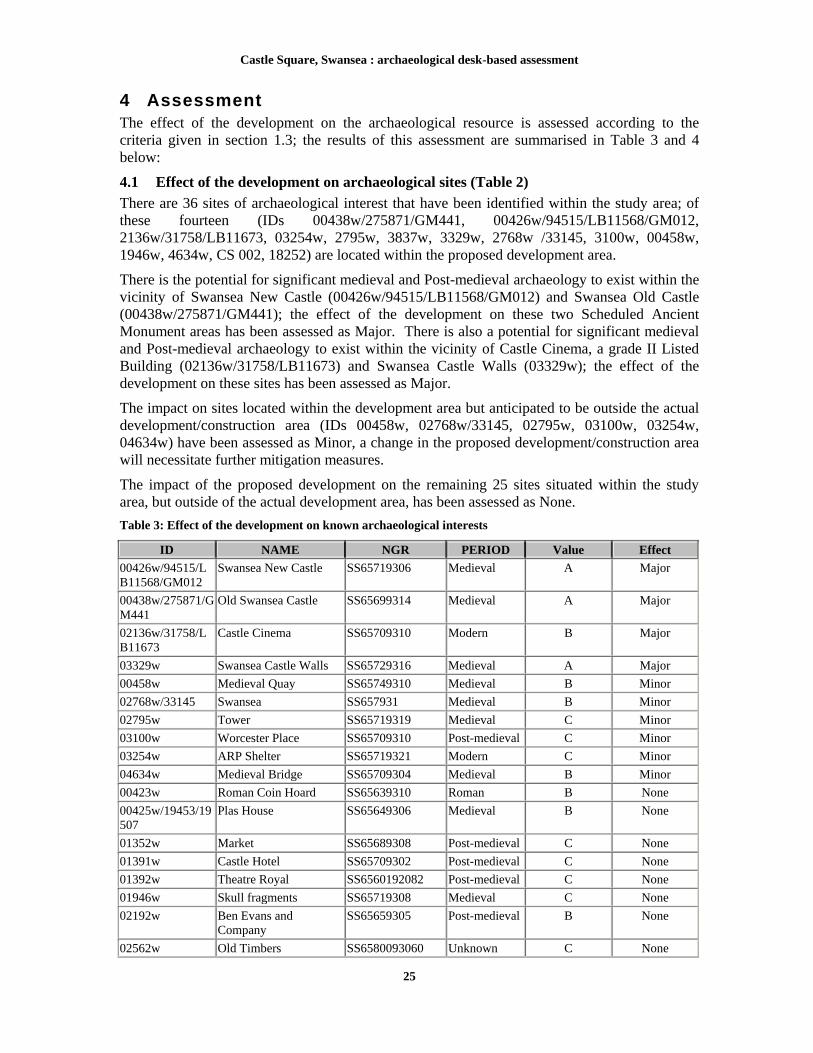
4 Assessment The effect of the development on the archaeological resource is assessed according to the criteria given in section 1.3; the results of this assessment are summarised in Table 3 and 4 below:
4.1 Effect of the development on archaeological sites (Table 2)
There are 36 sites of archaeological interest that have been identified within the study area; of these fourteen (IDs 00438w/275871/GM441, 00426w/94515/LB11568/GM012, 2136w/31758/LB11673, 03254w, 2795w, 3837w, 3329w, 2768w /33145, 3100w, 00458w, 1946w, 4634w, CS 002, 18252) are located within the proposed development area.
There is the potential for significant medieval and Post-medieval archaeology to exist within the vicinity of Swansea New Castle (00426w/94515/LB11568/GM012) and Swansea Old Castle (00438w/275871/GM441); the effect of the development on these two Scheduled Ancient Monument areas has been assessed as Major. There is also a potential for significant medieval and Post-medieval archaeology to exist within the vicinity of Castle Cinema, a grade II Listed Building (02136w/31758/LB11673) and Swansea Castle Walls (03329w); the effect of the development on these sites has been assessed as Major.
The impact on sites located within the development area but anticipated to be outside the actual development/construction area (IDs 00458w, 02768w/33145, 02795w, 03100w, 03254w, 04634w) have been assessed as Minor, a change in the proposed development/construction area will necessitate further mitigation measures.
The impact of the proposed development on the remaining 25 sites situated within the study area, but outside of the actual development area, has been assessed as None.
Table 3: Effect of the development on known archaeological interests
ID NAME NGR PERIOD Value Effect
00426w/94515/LB11568/GM012
Swansea New Castle SS65719306 Medieval A Major
00438w/275871/GM441
Old Swansea Castle SS65699314 Medieval A Major
02136w/31758/LB11673
Castle Cinema SS65709310 Modern B Major
03329w Swansea Castle Walls SS65729316 Medieval A Major
00458w Medieval Quay SS65749310 Medieval B Minor
02768w/33145 Swansea SS657931 Medieval B Minor
02795w Tower SS65719319 Medieval C Minor
03100w Worcester Place SS65709310 Post-medieval C Minor
03254w ARP Shelter SS65719321 Modern C Minor
04634w Medieval Bridge SS65709304 Medieval B Minor
00423w Roman Coin Hoard SS65639310 Roman B None
00425w/19453/19507
Plas House SS65649306 Medieval B None
01352w Market SS65689308 Post-medieval C None
01391w Castle Hotel SS65709302 Post-medieval C None
01392w Theatre Royal SS6560192082 Post-medieval C None
01946w Skull fragments SS65719308 Medieval C None
02192w Ben Evans and Company
SS65659305 Post-medieval B None
02562w Old Timbers SS6580093060 Unknown C None

Castle Square, Swansea : archaeological desk-based assessment
26
ID NAME NGR PERIOD Value Effect
03837w Medieval pottery SS65709316 Medieval C None
04607w 17 and 18 The Strand SS65769306 Post-medieval C None
04608w 19 The Strand SS65779307 Post-medieval C None
18252 1-4 Castle Square SS6571393027 Post-medieval C None
34239 Broadquay Warehouse SS658931 Post-medieval C None
34873 Great Western Railway North Dock Branch
SS65789320 Post-medieval C None
54087 5 Castle Square SS6571593021 Post-medieval C None
54088 6 Castle Square SS6571893016 Post-medieval C None 54089 7 Castle Square SS6573193018 Post-medieval C None

Castle Square, Swansea : archaeological desk-based assessment
27
4.2 Effect of development on newly identified and potential sites (Table 3)
A total of nine new sites have been identified; of these sites only one is located within the proposed development area (ID CS 002) as a result the impact of the proposed development on this site has been assessed as Minor.
The impact of the proposed development on eight of the newly identified sites (CS 001, CS 003-CS 009) situated outside of the development area has been assessed as None.
Table 4: Effect of the development on new or potential sites
PRN NAME NGR PERIOD Value Effect
CS 002 Post Office SS6569593085 Post-medieval C Minor
CS 001 Castle Square SS6562893056 Post-medieval C None
CS 003 Statue SS6570793011 Post-medieval C None
CS 004 Foundry SS6576893017 Post-medieval D None CS 005 Foundry SS6575493135 Post-medieval D None CS 006 Dock SS6578993202 Post-medieval C None CS 007 Independent Chapel SS6562193141 Post-medieval D None CS 008 Free Library SS6560293100 Post-medieval D None CS 009 Bank of England SS6562693083 Post-medieval D None
Castle Square, Swansea : archaeological desk-based assessment
28
5 Mitigation The follow mitigation scheme is presented as guide only as detailed information regarding the construction design and method is limited at this time to a general proposal to re-develop the entire site. Should a detailed construction method and design be provided at a later date a more detailed mitigation strategy can be produced. Figure 9 shows a phased period plan of the Swansea Castle area and details the areas known to contain substantial archaeological deposits of the medieval and Post-medieval periods; the red-line development area represents the area where archaeological works should take place.
5.1 Mitigation of the impact of the development upon known and newly identified archaeological interests
The proposed development has been assessed as having a Major effect on four sites identified within the development area, Swansea New Castle (ID 00426w/94515/LB11568/GM012), Swansea Old Castle (00438w/275871/GM441), Swansea Castle Walls (03329w) and the Castle Cinema (02136w/31758/LB11673).
It should be noted that any form of works within the boundaries of Scheduled Ancient Monuments will need Scheduled Monument Consent granted by Cadw and any alterations to a Listed Building will need Listed Building Consent, also provided by Cadw.
Swansea New Castle, Swansea Old Castle and Swansea Castle Walls (Areas 1, 3, 4, 5, 6, 7, 8a, 8b and 9)
Swansea New Castle (00426w/94515/LB11568/GM012) is a Scheduled Ancient Monument and a Grade I Listed Building and Swansea Old Castle (00438w/275871/GM441) is a Scheduled Ancient Monument. Swansea Castle Walls (03329w) is not currently protected as a Scheduled Ancient Monument, however, these remains form an integral part of the castle site, providing important information on the development of the centre of Swansea. The archaeological remains from all three sites are substantial and well preserved. Therefore, it is suggested that the impact of the development upon these sites be mitigated by a programme of archaeological works, a more detailed assessment of which techniques should be applied in each area is provided in Section 5.2 below.
Castle Cinema (Area 8a and 8b).
Castle Cinema (02136w/31758/LB11673) is a Grade II listed building and as such it is recommended that a Level 2 Building Survey, as set out in English Heritage’s Understanding Historic buildings: A guide to practice (2006), should be conducted on this structure before the the structure is demolished. It should also be noted that part of the southeastern wall of the Castle Cinema forms part of boundary for the Scheduled Ancient Monument of Swansea New Castle (00426w/94515/LB11568/GM012).
During 1996 and 1997 GGAT conducted a watching brief on work within Worcester Place, which identified that the south curtain wall remained in situ below the north wall of the Castle Cinema (Areas 8a and 8b). Therefore, an intensive watching brief with contingencies should be conducted during the demolition of the Castle Cinema to identify and record the known medieval deposits and structures should they be encountered during this process. Should significant remains be encountered during the intensive watching brief a contingency for further investigation of the area may be appropriate prior to development of the cinema site.
Effected sites located within the development area but anticipated to be outside the actual development/construction area (Areas 1 and 3)
The proposed development has been assessed as having a Minor effect on seven sites identified within the development area (IDs 00458w, 02768w/33145, 02795w, 03100w, 03254w, 04634w,

Castle Square, Swansea : archaeological desk-based assessment
29
18252 and CS002). The significance of the effect on these seven sites has been assessed as minor, as it is currently thought that though they are located within the development area they will be outside the actual areas of construction. At this time it is suggested that the impact of the development upon these seven sites can be mitigated by the implementation of an intensive watching brief with contingencies. Any changes to the areas of construction will necessitate additional mitigation measures.
5.2 Mitigation of the impact of the development upon previously identified archaeological deposits
Swansea New Castle, Swansea Old Castle and Swansea Castle Walls (Areas 1, 3, 4, 5, 6, 7, 8a, 8b, 9)
The southern half of the Worcester Street car park is located within the Scheduling Ancient Monument area of the Swansea Old Castle (00438w/275871/GM441). The area to the north of the Scheduled Ancient Monument area has been greatly disturbed by the insertion of Post-medieval cellars. However, despite this disturbance previous archaeological investigations have proven the survival of significant medieval deposits in this area.
In 1988 a series of twelve test pits identified numerous cellars associated with the Post-medieval occupation of the land between Worcester Place and The Strand (GGAT 1988). Medieval deposits were recorded beneath these Post-medieval cellar floors at Nos. 2 and 3 Worcester Place at depths of around 1.6-2.5 metres below the modern tarmac surface (Area 4). Another test pit recorded a deposit of ashy material including some areas of burnt clay, oyster shells and fragmented slates thought to have been medieval at a depth of 1.7 metres to 1.8 metres. Close to the western edge of Worcester Place a medieval deposit was recorded at a shallow depth of 1 metre below the present ground level containing a cobble/gravel layer, flecks of oyster shell, animal bone and some 13th/14th century pottery, possibly representing ‘the levelled top of the earthwork castle’. Medieval deposits were also encountered at depths ranging from 0.9 metres, at the western end of the Strand car park, to around 2.5 metres along Worcester Place.
The potential for surviving medieval archaeological deposits to be encountered in the area of Swansea Old and New Castles, on Castle Street, Worcester Place and the Strand is extremely high, as attested to by the upstanding medieval structure of Swansea New Castle, the buried medieval deposits associated with Swansea Old Castle and the medieval deposits recorded below the Post-medieval cellars a short distance to the south of the Worcester Place car park. It is therefore recommended that an intensive archaeological watching brief with contingencies be conducted on all groundworks in the areas of Swansea New and Old Castles, specifically on Worcester Place, The Strand and Castle Street.
Revetment bank on the western border of The Strand (Areas 4, 5, 6, 7 and 8a).
The far western area of the revetment bank along the western edge of The Strand falls within the Scheduling Boundary of Swansea Old Castle (00438w/275871/GM441), whilst the entire revetment bank forms part of the Swansea Castle Walls (03329w) site (Areas 4, 5, 6, 7 and 8a).
In 1994 a Ground Penetrating Radar survey (Stratascan 1994) across the area of the revetment bank indicated the survival of the northern wall of the castle and a rapid survey of extant walls across this part of the site identified at least two walls that had their origins in the 13th century or earlier. Following these results an archaeological evaluation was conducted; a number of features were discovered that related to the stone castle, including the northern wall of the outer bailey, a floor composed of mortared rubble was also uncovered, these features appeared consistent to the results indicated by Stratascan. The southern area (sites of Nos. 5-7 Worcester Place, now demolished) was occupied by rubble filled cellars of 18th century houses, these

Castle Square, Swansea : archaeological desk-based assessment
30
structures were located to a depth of 2.3 metres below the ground surface; the southern face of the inner bailey wall was indicated to be surviving underneath the cellar of No. 6 Worcester Place (Evans 1994).
The potential for surviving medieval archaeological deposits to be encountered in the area of the revetment bank on the Strand is extremely high. Despite later Post-medieval development in the area, archaeological investigations have proven significant deposits survive but their extent is not known. Therefore, it is therefore recommended that an intensive archaeological watching brief should be conducted on all ground works in this area, with a contingency in place to excavate and record substantial archaeological deposits should they be encountered.
1-4 Castle Square
1-4 Castle Square is outside of the boundaries of either Scheduled Ancient Monument, however, well preserved archaeological remains dating to the Post-medieval and medieval periods are highly likely to exist on the site.
No previous archaeological work has been conducted on the site of 1-4 Castle Square, however, two stone structures identified as possible medieval bridge abutments or the remains of an outer barbican to Swansea Castle where identified in a sewer trench excavated a short distance to the west of this plot. This suggests that well preserved medieval archaeology could exist on the site; as a result it is recommended that an archaeological evaluation, consisting of trenching, be conducted at 1-4 Castle Square in order to determine the nature of archaeological resource in this area.
5.3 Mitigation summary
It is recommended that the red-line development area shown on Figures 2-9 should represent the total area to be covered by an intensive archaeological watching brief during all ground works but especially those works being carried out below 1 metre in depth. Particular attention during the intensive watching brief should be paid to the shaded areas (1-12, Figure 9) found inside of the development area where significant archaeological deposits are known to exist (see Section 5.1-5.2 above).
A Level 2 Building Survey, as set out in English Heritage’s Understanding Historic buildings: A guide to practice (2006), should be conducted on Castle Cinema (02136w/31758/LB11673) before the structure is demolished. The south curtain wall remains in situ below the north wall of the cinema (Areas 8a and 8b); therefore, an intensive watching brief with contingencies should be conducted during the demolition. Should significant remains be encountered during the intensive watching brief, a contingency allowing for further investigation of the area would be appropriate prior to development of the cinema site.
The discovery of the remains of a medieval barbican tower or bridge abutment in close proximity to 1-4 Castle Street, at a shallow depth (1 metre), indicates the high potential for encountering significant medieval deposits and structures. However, since the nature of the archaeological resource at 1-4 Castle Street is not fully understood a programme of archaeological investigation consisting of trial trenching (evaluation) should be implemented before any ground works take place on the site.

Castle Square, Swansea : archaeological desk-based assessment
31
Bibliography
Dowdell, G, 1976, ‘The castle’ and ‘Cross Keys, Princess Way’ in Arch in Wales no.16 p42
Evans, E, 1983, Swansea Castle and the Medieval Town, Swansea City Council and GGAT
Evans, E, M, 1994, Archaeological field evaluation, Worcester Place, Swansea: Stage One, GGAT Report No: 94/053
Evans, E, M, 1995a, Archaeological field evaluation, Worcester Place, Swansea: Stage two, excavations on the Worcester Place car park, GGAT Report No: 95/023
Evans, E, M, 1995, Archaeological field evaluation, Worcester Place, Swansea: Watching brief on geotechnical test pits, boreholes and cores, GGAT Report No: 95/66
Evans, P, 2001, Archaeological watching brief: Wind Street, Swansea. Cambrian Archaeological Projects Report no:201
GGAT, 1988, Proposed North Dock development, Swansea: Report on Archaeological Implications, GGAT Report No: 11
Gower Volume XXVII, 1976, The Journal of the Gower Society p14-19
Griffiths, R, A, 1978, Boroughs of Medieval Wales, University of Wales Press, Cardiff
GSB Prospection, 2002, Geophysical Survey Report, Report 2002/96
Higgins, J, 2008, Excavations at the former David Evans store, Princess Way, Swansea: post excavation assessment, GGAT Report No: 2008/030
Hill, C, 1987, Proposals for the excavation and display of Swansea Castle at Worcester Place, GGAT Report No:2426
Hill, C, 1989, An environmental assessment of the archaeological implications of development at Worcester Place, Swansea
Howell, J, K, 2000a, 61 Wind Street, Swansea: archaeological watching brief, GGAT Report No: 2000/040
Howell, J, K, 2000b, 215-221 High Street, Swansea: archaeological assessment, GGAT Report No: 2000/022
John Samuels Archaeological Consultants, 2001, An Assessment of the impact of proposed development on the archaeological resource at Castle Quays, Swansea, JSAC Report No: 723/01/01
John Samuels Archaeological Consultants, 2002, An Assessment of the impact of proposed development on the archaeological resource at Castle Quays, Swansea, JSAC Report No: 723/02/02
John Samuels Archaeological Consultants, 2002, A Specification for Archaeological Evaluation Excavation at Castle Quays, Swansea, JSAC Report No: 723/02/03
John Samuels Archaeological Consultants, 2003, An Assessment of the impact of proposed development on the archaeological resource at Castle Quays, Swansea, JSAC Report No: 723/03/05
John Samuels Archaeological Consultants, 2005, An Archaeological Impact Assessment on the Former David Evans Store, Swansea, JSAC Report No: 723/05/06
Lightfoot, K, 1979, ‘The medieval town defences of Swansea: The Whitewalls Excavation, 1978-79’, in Gower XXX, 76
Ludlow, N, 1999, 1-4 Castle Square, Swansea, An archaeological assessment, Cambria Archaeology

Castle Square, Swansea : archaeological desk-based assessment
32
Maynard, D, 1995, Archaeological desk-based assessment Wind Street, Swansea, GGAT Report No: 95/027
Morgan W L, 1914, The Castle of Swansea, George Simpson and Co., Devizes
Morris, B, 1975, ‘Swansea’s medieval defences – some recent discoveries’, in Gower XXVI, 11
Morris, B, 1993, Swansea Castle, Swansea History Project, Swansea
Roberts, R, 2002 Land between Wind Street and York Street, Swansea: archaeological excavation, Area 2, Report on Task 5, GGAT Report No: 2002/079
Rogers, W. C, 2005, Historic Swansea, The West Glamorgan Archive Service, Swansea
RCAHMW, 2000, An inventory of the Ancient Monuments in Glamorgan Volume III-Part1b, Medieval Secular Monuments The Later Castles from 1217 to the present,
Sell, S, H, 1993, ‘Excavations at St Mary’s Swansea 1976-77’, in Arch in Wales, Volume: 33, 1
Sell, S, H, 1996, Archaeological watching brief Swansea Castle, GGAT Report No: 97/022
Sell, S, H, 1997, Worcester Place, Swansea, archaeological watching-brief, November 1996 – March 1997, GGAT Report No: 97/041
Sell, S, H, 1997, Worcester Place, Swansea, archaeological watching-brief. Interim Report, November 1996 – January 1997, GGAT Report No: 97/003
Sell, S, H and Sherman, A, 2006 Excavations on land between York Street and Wind Street, Swansea, May 2006, GGAT Report No: 2006/036
Soil Survey of England and Wales, 1983, 1:250,000 Soil Map of England and Wales and Legend, Soil Survey of England and Wales, Harpenden
Sherman, A, 2004, The Bank Statement, 57-58 Wind Street, Swansea: archaeological watching-brief, GGAT Report No: 2004/043
Sherman, A, 2006, 1-7 Princess Way, Swansea: archaeological watching-brief, GGAT Report No: 2006/053
Soulsby, I, 1983, The Towns of Medieval Wales, Phillimore, Chichester
Stephenson, A, 1998, Archaeological desk based assessment: Castle Quays, Swansea, CgMs Consulting
Stratascan, 1994, A report for Glamorgan Gwent Archaeological Trust on a ground probing radar survey carried out at Worcester Place, Swansea
Taylor, E, 2002, An archaeological evaluation at 26 Castle buildings, Castle Quays, Swansea: Northamptonshire Archaeology
Williams, G, 1990, Swansea: an illustrated history, Christopher Davies, Swansea
Websites
Swanseaheritage.net, 09/06/2009, http://www.swanseaheritage.net/swanseathroughtheyears
Cartographic sources
Ordnance Survey 1:2500, 1879, First Edition. Issue number 24.5
Ordnance Survey 1:2500, 1899, Second Edition. Reference number D/D A/B
Ordnance Survey 1:2500, 1919, Third Edition. Reference number O/S GCC
1843 Tithe map of St Mary’s Parish
Local Board of Health map of Swansea 1852
Local Board of Health map of Swansea 1855


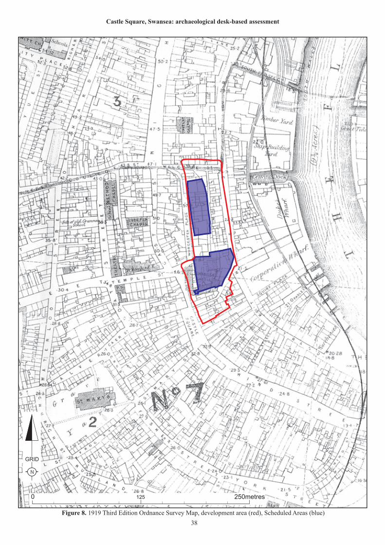


Castle Square, Swansea : archaeological desk-based assessment
40
Appendix II
Walkover Survey
Plate 1: South block of Swansea Castle view to the south east
Plate 2: North-East Tower (formerly the Debtor’s Prison), the doorway illustrates the rise of the ground
level, view to the north

Castle Square, Swansea : archaeological desk-based assessment
41
Plate 3: Arcading of south block of the castle, view to the north
Plate 4: Former site of 1-4 Castle Square situated to the south of the New Castle and Castle Lane and to the
north of No. 5 Castle Square, view to the east
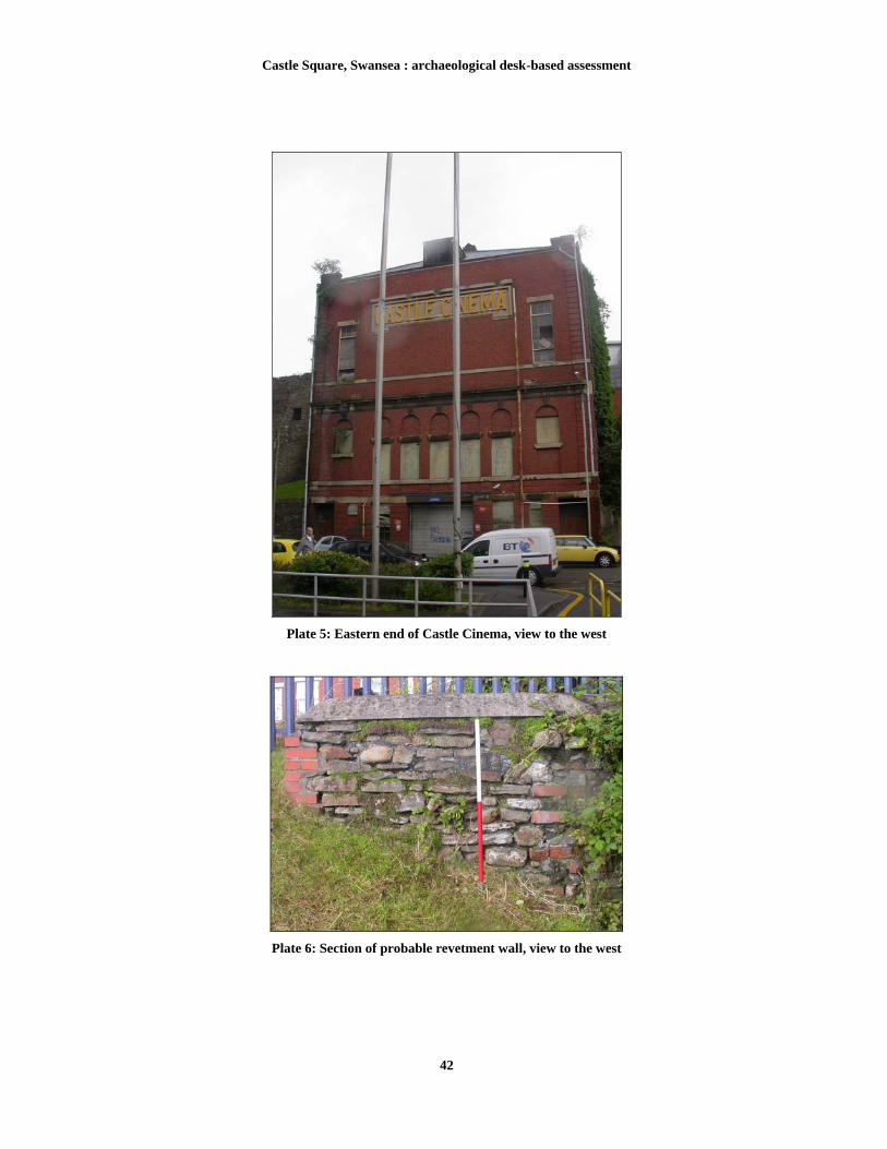
Castle Square, Swansea : archaeological desk-based assessment
42
Plate 5: Eastern end of Castle Cinema, view to the west
Plate 6: Section of probable revetment wall, view to the west

Castle Square, Swansea : archaeological desk-based assessment
43
Plate 7: Northern area of Worcester Place car park, view to the south
Plate 8: Green Dragon Lane with 19th century cobbling, located in the south of the study area, view to the
west

Castle Square, Swansea : archaeological desk-based assessment
44
Plate 9: Castle Lane Buildings view to the south east
Plate 10: Statue of Sir H Hussey Vivian in the new location of St Mary’s Square, view to the south

Castle Square, Swansea : archaeological desk-based assessment
45
Plate 11: 40-41 Castle Square, with Castle cinema in the background view to North East
Plate 12: Castle Square, showing the New Castle and BT Tower, view to the east

Castle Square, Swansea : archaeological desk-based assessment
46
Pictorial evidence
Plate 13: ‘The East View of Swansea Castle in the County of Glamorgan’ by S & N Buck, 1741
Plate 14: ‘Swansey in Wales’ by Francis Place c1680
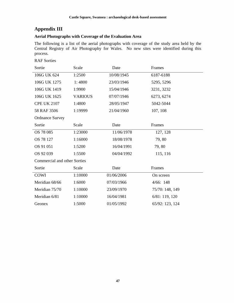
Castle Square, Swansea : archaeological desk-based assessment
47
Appendix III
Aerial Photographs with Coverage of the Evaluation Area
The following is a list of the aerial photographs with coverage of the study area held by the Central Registry of Air Photography for Wales. No new sites were identified during this process.
RAF Sorties
Sortie Scale Date Frames
106G UK 624 1:2500 10/08/1945 6187-6188
106G UK 1275 1: 4800 23/03/1946 5295, 5296
106G UK 1419 1:9900 15/04/1946 3231, 3232
106G UK 1625 VARIOUS 07/07/1946 6273, 6274
CPE UK 2107 1:4800 28/05/1947 5042-5044
58 RAF 3506 1:19999 21/04/1960 107, 108
Ordnance Survey
Sortie Scale Date Frames
OS 78 085 1:23000 11/06/1978 127, 128
OS 78 127 1:16000 18/08/1978 79, 80
OS 91 051 1:5200 16/04/1991 79, 80
OS 92 039 1:5500 04/04/1992 115, 116
Commercial and other Sorties
Sortie Scale Date Frames
COWI 1:10000 01/06/2006 On screen
Meridian 68/66 1:6000 07/03/1966 4/66: 148
Meridian 75/70 1:10000 23/09/1970 75/70: 148, 149
Meridian 6/81 1:10000 16/04/1981 6/81: 119, 120
Geonex 1:5000 01/05/1992 65/92: 123, 124

Castle Square, Swansea : archaeological desk-based assessment
48
Appendix IV
Apportionments relating to the tithe map of 1843 for the Parish of St Mary’s, Swansea
Land owner Occupier Parcel
number Name and description of
parcel
Davies John John Jones 2711 Castle Street
Davies John Evan Williams 2718 Castle Street
Governor and Company of the Bank of England
Governor and Company of the Bank
of England 2171 Temple Street
Gronow William John Andrew 2732 Strand
Grove John Michael Marks 2720 Castle Street
Grove John Thomas Glover 2721 Castle Street
Grove John Mary Watkins 2725 Worcester Place
Grove John John Williams 2726 Worcester Place
Grove John John Williams 2727 Worcester Place
Jones Calvert Richard Esq.
Mary Cade 2732
Terry William William Terry 2731
Thomas Thomas Edward John Rhyderch 2728 Worcester Place
Thomas Thomas Edward George Richards 2729 Worcester Place
Thomas Thomas Edward Thomas Gregory 2730 Worcester Place
27?? Apportionment illegible (located next to castle)
Grove John John Williams 2727 Worcester Place
Beaufort Duke of Henry Jones 2722 Garden Worcester Place

Castle Square, Swansea : archaeological desk-based assessment
49
Appendix V
Tenant occupations relating to the tithe map of 1875-6 for the Parish of St Mary’s, Swansea from the Trade Registers Directory of Trades (STR/DIR).
Address Occupier Occupation
1 Castle Yard (Richards and Billing Builders) Davies David Builders
1 Castle Yard (Richards and Billing Builders) Jones D.H Locksmith
1 Castle Yard (Richards and Billing Builders) Fowler John B Architect
1 Castle Yard (Richards and Billing Builders) Brown and Collins
Rosser A Solicitors
Mattress Maker
2 Castle Yard Sandbrook John Joiner
3 Castle Yard Nutt John Insurance Agent
4 Castle Yard Fender Dd. Pilot’s Assistant
5 Castle Yard Horn Mrs. Mary Ann School
6 Castle Yard Osbourne Geo. Drill Sergeant
7 Castle Yard Davies John Boiler Maker
8 Castle Yard Richards J & W Drapers and Co.
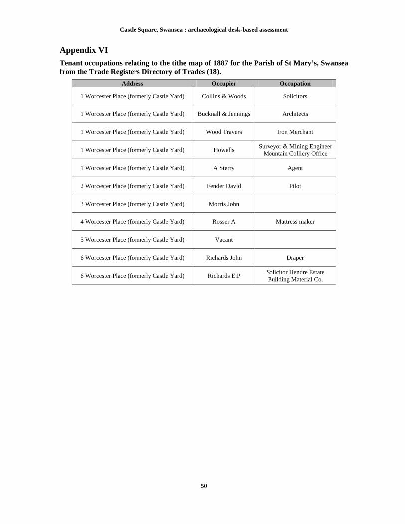
Castle Square, Swansea : archaeological desk-based assessment
50
Appendix VI
Tenant occupations relating to the tithe map of 1887 for the Parish of St Mary’s, Swansea from the Trade Registers Directory of Trades (18).
Address Occupier Occupation
1 Worcester Place (formerly Castle Yard) Collins & Woods Solicitors
1 Worcester Place (formerly Castle Yard) Bucknall & Jennings Architects
1 Worcester Place (formerly Castle Yard) Wood Travers Iron Merchant
1 Worcester Place (formerly Castle Yard) Howells Surveyor & Mining Engineer
Mountain Colliery Office
1 Worcester Place (formerly Castle Yard) A Sterry Agent
2 Worcester Place (formerly Castle Yard) Fender David Pilot
3 Worcester Place (formerly Castle Yard) Morris John
4 Worcester Place (formerly Castle Yard) Rosser A Mattress maker
5 Worcester Place (formerly Castle Yard) Vacant
6 Worcester Place (formerly Castle Yard) Richards John Draper
6 Worcester Place (formerly Castle Yard) Richards E.P Solicitor Hendre Estate Building Material Co.

Castle Square, Swansea : archaeological desk-based assessment
51
Appendix VII
Gazetteer of archaeological interests
ID 00423w Name Roman Coin Hoard NGR SS65639310 Period Roman Full description In 1871, four coins, representing AD 205 - 337 were found together at 9 Castle Bailey Street, which extends between College Street to Temple Street. Type Condition Status Coin hoard Moved None Rarity Group Association Historical Association High Low Unknown Confidence Value Effect Medium B None ID 00425w/19453/19507 Name Plas House NGR SS65649306 Period Medieval Full description A manor house of 'Elizabethan character' with a highly unusual octagonal tower. There is no record of when construction began, although the greater part was erected (or rebuilt) by Sir Matthew Craddock. His arms, together with those of the Herberts and the Earl of Worcester, appeared over the main gateway. This gateway was destroyed during the construction of Temple Street, with the remaining structure being pulled down in 1840. The majority of the building material was then re-used at Singleton Farm (PRN 02887w). It is unlikely that the house was occupied after 1736 and was used as a barn and stable at the time of its destruction Type Condition Status Manor house Destroyed None Rarity Group Association Historical Association High Medium Certain (Medium) Confidence Value Effect High B None ID 00426w/94515/LB11568/ GM012 Name Swansea New Castle NGR SS65719306 Period Medieval Full description The surviving and impressive stonework remains seen at Castle Bailey Street are the ruins of the New Swansea Castle, dating to the late 13th to early 14th century. An archaeological testament to the Welsh wars and conquest of Edward I (1272-1307), the Castle was originally part of a much larger stronghold. It was built alongside the Old Castle by the de Braose Lords of Gower, and what started as a set of apartments developed into a self-contained castle. On the first floor was a hall, solar, and service rooms, with vaulted basements below. The arcaded parapet is perhaps the work of Henry de Gower, Bishop of St Davids (1328-47); similar work can be seen at Lamphey and St Davids. The castle was decayed by 1650, although by 1686 there was a glassworks within the ruins, and in the late 18th century, the north block was remodelled as a prison. In 1729 a large, tall gabled house was raised close to the east side of the castle, on the Strand. It was leased in 1734 to James Griffiths who had been prominent in founding a copper works further along the Strand in around 1720. The house survived until the early 19th century when it appeared in a dilapidated condition in several views, and finally shown as a derelict building in a model of Swansea in 1840. In 1912, considerable alterations were made to the remains of the New Castle by the erection of the offices of the 'Cambrian Daily Leader' later ‘The Evening Post’ newspaper. A large portion of the north curtain wall was destroyed. (Hill 1989). Type Condition Status Castle Damaged SAM/LBI
Rarity Group Association Historical Association High High Certain (High)
Confidence Value Effect High A Major

Castle Square, Swansea : archaeological desk-based assessment
52
ID 00438w/275871/GM441 Name Old Swansea Castle NGR SS65699314 Period Medieval Full description The visible remains of the medieval curtain consists of a band of roughly coursed rubble, much patched and repaired and largely masked by recent masonry. Henry de Beaumont, Earl of Warwick was invited by the king c1106 to conquer Welsh Gwyr, and on completion, he established Swansea as its capital and constructed a motte-and-bailey castle for its defence. The first documentary evidence dates to 1116, when the castle was attacked by Gruffudd ap Rhys, and although the outer castle was burnt the tower remained intact. The castle was attacked on two further occasions, in 1192 and 1215. The structure was in the hands of Reginald de Braose during this time and he later surrendered to Llewelyn ap Iorwerth in 1217; later in the same year it was destroyed by Rhys Gryg in reprisal for the siege of Caerleon by the English. Further attacks by the Welsh took place in 1257 and 1287, but only limited mention is made in the documentary sources. "For two hundred years it [the motte and bailey castle] was a key and strategically important fortress, the administrative and financial centre of the Lordship of Gower and a vital baronial and royal base in South Wales". By 1300 however, with the end of the Welsh Wars, the military function of the castle was becoming less important, although its importance as the administrative centre of the lordship and one of de Braose's principal seats was undiminished. The earth and timber castle was eventually replaced with a stone one, but exactly when this took place is unclear. Sources dating to 1187 and 1212 refer to rebuilding but the sums of money involved appear too small for this undertaking. A date some time in the 13th century seems reasonable however, as other Gower castles, such as Penmaen and Oystermouth, were rebuilt in stone during this period. This castle was later to become known as the 'Old Castle'. Surrounding the castle was the castle ditch that was later incorporated into the New Castle. The following hundred years proved to be a period of uncertainty with parts of the castle being sold by the de Braose family. Between 1332 and 1347, however, a second castle ('New Castle' PRN 426w) was constructed, supposedly by the Bishop of Gower for the de Mowbray family. In appearance this looked more like a fortified manor house than a castle, the south (remaining) facade resembling the Bishops Palace at St Davids, Dyfed. In 1534, the commissioners of the Earl of Warwick visiting the town preferred to stay at the Boar's Head Inn rather than the castle, and by 1583 the buildings of the castle were 'in decay' according to a survey carried out in the same year. The decayed nature of the castle meant that in time the site was re-used; firstly in 1686 the Duke of Beaufort granted a to Messrs Willmot and Mann for the construction of a glassworks within the castle walls, and during the 18th century the north block was remodelled as a debtors prison. It was during this period that the castle ditch finally went out of use, as indicated by the work carried out by Morris (1976,17). He excavated part of the ditch and uncovered pottery dating to the 17th-18th century within the uppermost fill. It is also interesting that the east side of Goat Street, although within the town walls, remained as open waste ground until it was developed in the 1770s (Hill. 1989). Type Condition Status Castle Not known SAM
Rarity Group Association Historical Association High High Certain (High)
Confidence Value Effect High A Major ID 00458w
Name Medieval Quay NGR SS65749310 Period Medieval
Full description During rebuilding operations at the rear of Swansea Castle, excavations revealed the remains of a small quay on the site of the old Tawe riverbed. The riverbank was found to have been revetted with piles and oak planks, and posts (possibly for mooring) were set a few feet from the edge. An oak anchor stock and the skull of a horse, in which was embedded an early type of cannon ball were also discovered.
Type Condition Status Quay Near destroyed None
Rarity Group Association Historical Association High High Unknown
Confidence Value Effect High B Minor ID 01352w Name Market NGR SS65689308 Period Post-medieval Full description A Post-medieval market of unknown origin. Type Condition Status Market Not known None Rarity Group Association Historical Association Low High Unknown Confidence Value Effect Low C None

Castle Square, Swansea : archaeological desk-based assessment
53
ID 01391w Name Castle Hotel NGR SS65709302 Period Post-medieval Full description A Post-medieval hotel that was listed on the Cadw's 1974 index of Buildings of Special Architectural and Historic Interest, this building is now destroyed and is not currently Listed. No further information available. Type Condition Status Inn Destroyed None Rarity Group Association Historical Association Low High Unknown Confidence Value Effect Low C None ID 01392w Name Theatre Royal NGR SS6560193082 Period Post-medieval Full description A post-medieval theatre, depicted on the first edition (1879) Ordnance Survey map and also visible on the 1855 and 1852 Local Board of Health maps. The structure was later demolished prior to the construction of the David Evans Department Store. Type Condition Status Theatre Destroyed None Rarity Group Association Historical Association Low High Unknown Confidence Value Effect Medium C None ID 01946w Name Skull fragments NGR SS65719308 Period Medieval Full description Fragments of skulls and upper cervical vertibrae were recovered from two inhumations in the northwest part of the area excavated mechanically in 1976. A further thirteen inhumations 'of unusually large size' were noted in the barrack yard of the police court which formed part of the old town hall at the time of its demolition. A series of east – west orientated inhumations of both sexes were found in the interior of the New Castle when it was excavated for the offices of the Cambrian Daily Leader in 1912 (Morgan 1914, 19-21, 49, 6). There has been some conjecture that this represents the site of a pre-Norman church, but they could also be felons executed and buried whilst the Castle was in use as a prison (RCAHMW 2000, 351, 359).
Type Condition Status Inhumation Moved None
Rarity Group Association Historical Association High Low Unknown
Confidence Value Effect High C None
ID 02136w/31758/LB11673 Name Castle Cinema NGR SS65709310 Period Modern Full description A modern cinema, built between 1912 and 1914. The architectural firm C S Thomas, Meager and Jones of Swansea designed the building for the Andrews family of Cardiff. The structure of the building was damaged by fire in 1927 and by bombing in 1944; the interior was refitted 1962. The Worcester Place front is of classical design with Beaux Arts influence, with a giant Doric order treatment, triglyph frieze, a heavy cornice, an openwork parapet with enriched supports and latticework panels .
Type Condition Status Cinema Near intact LBII
Rarity Group Association Historical Association Medium Low Certain (Medium)
Confidence Value Effect High B Major

Castle Square, Swansea : archaeological desk-based assessment
54
ID 02192w Name Ben Evans and Company NGR SS65659305 Period Post-medieval Full description A 19th century department store often referred to as Wales’ first and grandest department store and the Harrods’ of Wales. The original shop was founded before the late 1870’s and occupied a single plot on Castle Street, with the main entrance onto Temple Street and a rear entrance onto Castle Street. Over the next decade the surrounding businesses including the Wheatsheaf Inn next door and Lee’s Boot and Shoe Depot opposite were bought up and converted into departments of the store. These buildings were demolished between 1893 and 1894 and redeveloped into an ornate, imposing five storey building that housed 38 departments. The building was heavily damaged during the Three Nights’ Blitz of 21st February 1941, by 1953 the rubble had been cleared and the site redeveloped as Castle Gardens (Swanseaheritage.net, 09/06/2009).
Type Condition Status Department store Destroyed None Rarity Group Association Historical Association High Low Certain (High) Confidence Value Effect High B None
ID 02562w Name Old Timbers
NGR SS6580093060 Period Unknown
Full description During the 1970's construction of the BT Tower, 'old timbers' were excavated from a depth of 20 - 25ft below the ground surface. These timbers where subsequently destroyed. Type Condition Status Findspot Destroyed None
Rarity Group Association Historical Association Medium Low Unknown
Confidence Value Effect Medium C None
ID 02768w/33145 Name Swansea
NGR SS657931 Period Medieval
Full description Swansea possibly originated as a 9th-10th century, Scandinavian trading post, although there is a great deal of debate surrounding this issue. The first motte and bailey castle was constructed by 1116, and subsequently attacked and partially destroyed; a later castle was constructed to the north in c.1300. The first charter for the town originated between 1153 & 1184. The town was often a target for attack by the Welsh and as a result town walls were built in the early 14th century
Type Condition Status Settlement Not known None
Rarity Group Association Historical Association Medium High Certain (High)
Confidence Value Effect High B Minor
ID 02795w Name Tower
NGR SS65719319 Period Medieval
Full description A possible tower outlined by different masonry noted during a discussion on the possible development of the Worcester Place. Type Condition Status Tower Damaged None
Rarity Group Association Historical Association High Medium Unknown
Confidence Value Effect Low C Minor

Castle Square, Swansea : archaeological desk-based assessment
55
ID 03100w Name Worcester Place
NGR SS65709310 Period Post-medieval
Full description A Post-medieval road constructed in the late 18th century through the centre of Swansea Castle . Type Condition Status Road Damaged None
Rarity Group Association Historical Association Low Medium Unknown
Confidence Value Effect High C Minor
ID 03254w Name ARP Shelter
NGR SS65719321 Period Modern
Full description In the Second World War or during the run-up to it an Air-raid Precautions structure was built at the northern end of Worcester Place. The brick-built, western wall of this feature was recorded as still standing in 1994. Identified as an 'ARP Shelter'. This is the only known remaining civil defence site in Swansea City centre.
Type Condition Status Air raid shelter Near destroyed None
Rarity Group Association Historical Association High Medium Certain (Low)
Confidence Value Effect High C Minor
ID 03329w Name Swansea Castle Walls
NGR SS65729316 Period Medieval
Full description A rapid survey of the standing walls in the area between the Strand and Worcester Place car parks, Swansea, has established that at least two of these walls are of medieval origin and preserve masonry identical to that in the oldest (13th century) parts of the 'New Castle'. Other walls continuing this line may be on medieval foundations, or may incorporate medieval masonry within them, but it was not possible to establish this within the parameters of the rapid survey. The walls at the level of the Strand are all recent, and the only one of any historical interest is the west wall of the ARP shelter (see ID 03254w) at the northern end of the site. The ground-probing radar survey of the Worcester Place car park revealed the presence of a possible rampart to the castle.
Type Condition Status Wall Not known None
Rarity Group Association Historical Association High High Certain (High)
Confidence Value Effect High A Major ID 03837w Name Medieval pottery
NGR SS65709316 Period Medieval
Full description A small deposit of oyster shell, animal and some 13th - 14th century pottery were retained during the test-pitting of Worcester Place. This material was recovered at a depth of c1.0m below the present day ground surface. Type Condition Status Findspot Moved None
Rarity Group Association Historical Association Low Medium Certain (Low)
Confidence Value Effect High C None

Castle Square, Swansea : archaeological desk-based assessment
56
ID 04607w Name 17 and 18 The Strand NGR SS65769306 Period Post-medieval Full description A building was present on the site of number 17 The Strand by at least 1823. In 1853 was occupied by a merchant Franklin Meager and in 1875 was occupied by an independent grocers. By 1887 the building had been acquired by Phillips & Son, Grocers, of the adjoining number 3 Castle Square. There was little development to the rear of number 17 and along with number 18 The Strand was acquired by Paton & Co, Ironmongers, who, between 1897 and 1909, extended both properties westwards into the curtilage of numbers 2 - 4 Castle Square, obliterating the medieval property boundaries and the line of the town wall, with the construction of the warehouse that still survives on the site. Along with number 18, the property was in the hands of Evans, Jenkins & Co. by 1947. At this point the warehouse occupied both numbers 17 and 18 and was a large, three-storey structure of random local rubble, with red-brick quoins and surrounds. Type Condition Status Building Near destroyed None Rarity Group Association Historical Association Low High Certain (Low) Confidence Value Effect High C None ID 04608w Name 19 The Strand
NGR SS65779307 Period Post-medieval
Full description A building was present on the site of No. 19 by at least 1823, the frontage of which was depicted with a rectangular plan on the tithe map of 1843. The premises had been a tavern, called the Three Mariners, since at least 1830. The building appears to have been halved in area between 1843 and 1852, It appears to have been rebuilt before 1879. The property was renamed The Brecon Arms but some earlier fabric may have been retained. At no time was there any significant development to the rear. It ceased to be a tavern between 1909 and 1914 when it was the premises of Mrs Ezra Jones, `shopkeeper' . After a period of occupation by James and Edwards, Upholsterers the property was, in 1947, a rope store. By the 1980s it was again a public house, The Home of the Famous Pigg, but has been empty for some years. Type Condition Status Building Not known None
Rarity Group Association Historical Association Low High Certain (Low)
Confidence Value Effect High C None ID 04634w Name Medieval Bridge NGR SS65709304 Period Medieval Full description Two stone structures seen in sewer trench excavations in Castle Square. It is possible they were originally a bridge or perhaps a barbican to the castle. Type Condition Status Bridge Near destroyed None Rarity Group Association Historical Association Medium Medium Certain (Low) Confidence Value Effect Medium C Minor
ID 34239 Name Broadquay Warehouse NGR SS658931 Period Post-medieval
Full description A post-medieval warehouse. Type Condition Status Warehouse Not known None
Rarity Group Association Historical Association Low Medium Unknown
Confidence Value Effect Low C None

Castle Square, Swansea : archaeological desk-based assessment
57
ID 34873 Name Great Western Railway North Dock Branch NGR SS65789320 Period Post-medieval Full description Railway visible on 1st, 2nd and 3rd edition Ordinance Survey maps and the 1852 and 1855 Local Board of Health maps. The North Dock was closed in 1928. Type Condition Status Railway Not Known None
Rarity Group Association Historical Association Medium Medium Certain (Medium)
Confidence Value Effect High C None
ID 54088 Name 6 Castle Square NGR SS6571893016 Period Post-medieval Full description Late 19th Century, four-storey, two-bay brick facade with stuccoed ashlar dressings. Architectural details include channelled quoins, eaves band of facetted panels and modillions. Type Condition Status Shop Not Known None
Rarity Group Association Historical Association Low High Unknown
Confidence Value Effect High C None
ID 54089 Name 7 Castle Square NGR SS6573193018 Period Post-medieval
Full description Late 19th Century, three-storey building with an attic facade of Flemish influence. Architectural details include brick with ashlar dressings; shop front; eaves band and contrasting dressings; attic aedicule with scrolled sides and blocking.
Type Condition Status Shop Not Known None
Rarity Group Association Historical Association Low High Unknown
Confidence Value Effect High C None ID 54087 Name 5 Castle Square NGR SS6571593021 Period Post-medieval Full description Three-storey with brick facade of and attic with ashlar dressings and Flemish gable. Architectural details include wide early-20th century bay window on the first floor, and two sash windows with keystone and quoins on the second floor. Type Condition Status Shop Not Known None
Rarity Group Association Historical Association Low High Unknown
Confidence Value Effect High C None

Castle Square, Swansea : archaeological desk-based assessment
58
ID 18252 Name 1-4 Castle Square NGR SS6571393027 Period Post-medieval
Full description Three-storey building dating to the 18th or 19th century; there are architraves to first and second floor windows of building No. 2; a large first-floor window with transom to building No. 3 and hipped dormer to building No. 4. The buildings were fire-damaged in 1994 and were subsequently demolished Type Condition Status Building Destroyed None
Rarity Group Association Historical Association Low High Unknown
Confidence Value Effect High C None
ID CS 001 Name Castle Square NGR SS6562893056 Period Post-medieval Full description Formerly known as 'Castle gardens'. The recreational area was created in 1953, the gardens were constructed on land that had been derelict after the destruction of the Ben Evans store during the Second World War. The gardens formed an important feature of in the redevelopment of the town centre during the post war era. The gardens were redeveloped in the 1990s to create the new piazza style Castle Square
Type Condition Status Garden Near Destroyed None
Rarity Group Association Historical Association Low High Certain (Medium)
Confidence Value Effect High C None ID CS 002 Name Post Office NGR SS6569593085 Period Post-medieval Full description An ornate Tudor-Gothic post office was built on the site of the old town hall and opened in 1858, the building changed use to be the offices of the local newspaper. In 1901 the post office at the castle was replaced by a much larger building in Wind street (02403w). It was around this time the former building then served as a labour exchange and later as the local newspaper offices. The severe air raids of 1941 destroyed most of the post office building.
Type Condition Status Post Office Not Known None
Rarity Group Association Historical Association Low High Certain (Medium)
Confidence Value Effect High C Minor
ID CS 003 Name Statue NGR SS6570793011 Period Post-medieval
Full description Statue visible on 2nd and 3rd edition Ordinance Survey map but not named on the 1st edition Ordinance Survey map. The statue has been moved and is now situated by St Mary's Church. The statue has two inscriptions one reads 'This statue was erected by the citizens of Swansea and unveiled March 13th 1886 by Lord Aberdare in recognition of the eminent service rendered to this port and town by Lord Aberdare in recognition of the eminent service rendered to this port and town by Sir H Hussey Vivian Bart:M.P. First Baron Swansea of Singleton. Born 6 July 1821, died 28 November 1894. M.P. for: Truro 1852-7, Glamorgan 1857-85, Swansea District 1885 and until his peerage in 1893.' The other inscription details the history of the statue and reads ‘A brief history of Hussey Vivian's statue. 1886 unveiled by Lord Aberdare on the site of Island House Castle square, 1936 moved to Victoria Park, 1982 this plaque was unveiled 21st May by the Lord Mayor Councillor Tyssul Lewis.’ Type Condition Status Statue Moved None
Rarity Group Association Historical Association Medium Low Certain (Medium)
Confidence Value Effect High C None
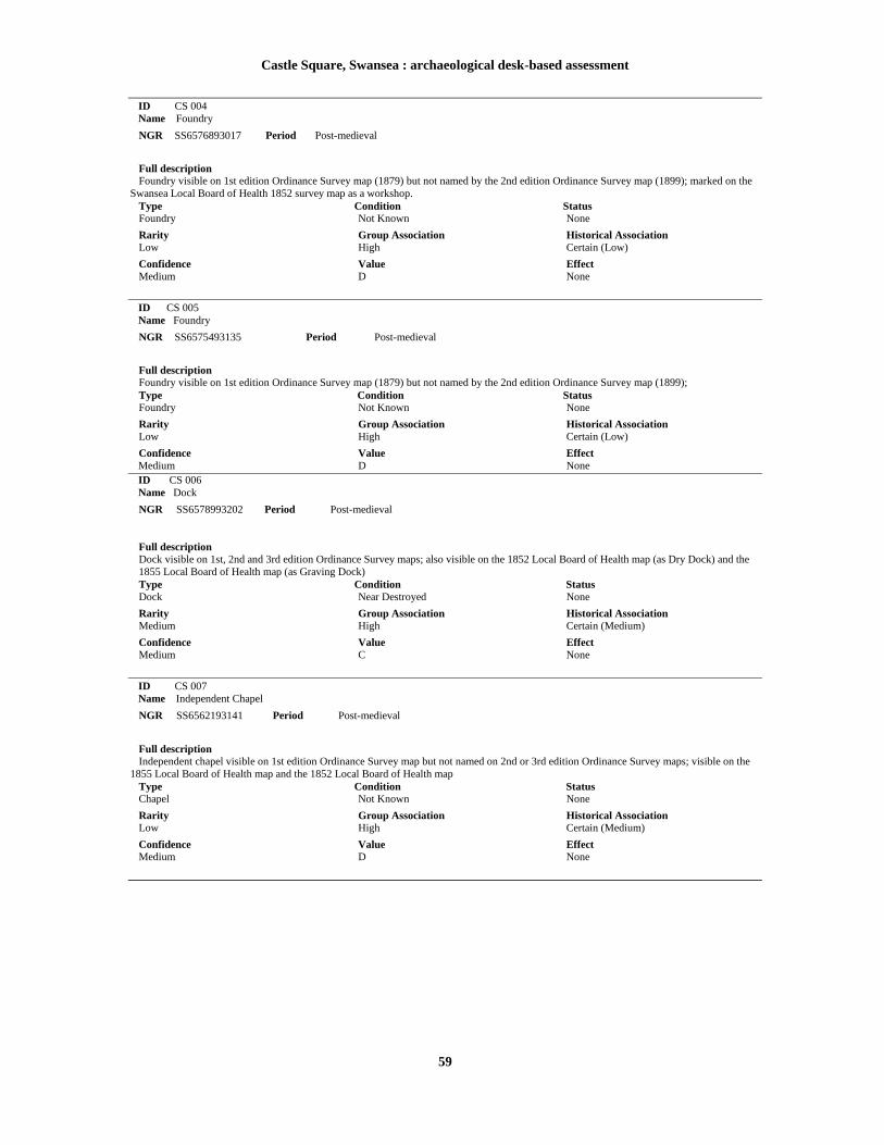
Castle Square, Swansea : archaeological desk-based assessment
59
ID CS 004 Name Foundry NGR SS6576893017 Period Post-medieval Full description Foundry visible on 1st edition Ordinance Survey map (1879) but not named by the 2nd edition Ordinance Survey map (1899); marked on the Swansea Local Board of Health 1852 survey map as a workshop. Type Condition Status Foundry Not Known None
Rarity Group Association Historical Association Low High Certain (Low)
Confidence Value Effect Medium D None
ID CS 005 Name Foundry NGR SS6575493135 Period Post-medieval Full description Foundry visible on 1st edition Ordinance Survey map (1879) but not named by the 2nd edition Ordinance Survey map (1899); Type Condition Status Foundry Not Known None
Rarity Group Association Historical Association Low High Certain (Low)
Confidence Value Effect Medium D None ID CS 006 Name Dock NGR SS6578993202 Period Post-medieval
Full description Dock visible on 1st, 2nd and 3rd edition Ordinance Survey maps; also visible on the 1852 Local Board of Health map (as Dry Dock) and the 1855 Local Board of Health map (as Graving Dock) Type Condition Status Dock Near Destroyed None
Rarity Group Association Historical Association Medium High Certain (Medium)
Confidence Value Effect Medium C None
ID CS 007 Name Independent Chapel
NGR SS6562193141 Period Post-medieval
Full description Independent chapel visible on 1st edition Ordinance Survey map but not named on 2nd or 3rd edition Ordinance Survey maps; visible on the 1855 Local Board of Health map and the 1852 Local Board of Health map Type Condition Status Chapel Not Known None
Rarity Group Association Historical Association Low High Certain (Medium)
Confidence Value Effect Medium D None

Castle Square, Swansea : archaeological desk-based assessment
60
ID CS 008 Name Free Library NGR SS6560293100 Period Post-medieval
Full description Library visible on 1st edition Ordinance Survey map but not named on the 2nd or 3rd edition Ordinance Survey map Type Condition Status Library Not Known None
Rarity Group Association Historical Association Low High Certain (Low)
Confidence Value Effect Medium D None ID CS 009 Name Bank of England NGR SS6562693083 Period Post-medieval
Full description Bank visible on 1st and 2nd edition Ordinance Survey map but not named on the 3rd edition Ordinance Survey map; also visible on the 1855 Local Board of Health map and the 1852 Local Board of Health map Type Condition Status Bank Not Known None
Rarity Group Association Historical Association Low High Certain (Medium)
Confidence Value Effect Medium D None