7uls .lw ,qgh[ 3ulqwhg rq )he 3djh -hss9lhz iru :lqgrzv · (*// /+5 /21'21 8. +($7+52: $,53257...
TRANSCRIPT

List of pages in this Trip Kit
Trip Kit IndexAirport Information For EGLLTerminal Charts For EGLLRevision Letter For Cycle 03-2020Change NoticesNotebook
Trip Kit IndexPrinted on 06 Feb 2020Page 1(c) JEPPESEN SANDERSON, INC., 2020, ALL RIGHTS RESERVED
jep=JEPPESEN
JeppView for Windows

General Information
Location: LONDON GBRICAO/IATA: EGLL / LHRLat/Long: N51° 28.65', W000° 27.68'Elevation: 83 ft
Airport Use: PublicDaylight Savings: ObservedUTC Conversion: +0:00 = UTCMagnetic Variation: 0.0° E
Fuel Types: Jet A-1Repair Types: Major Airframe, Major EngineCustoms: YesAirport Type: IFRLanding Fee: YesControl Tower: YesJet Start Unit: NoLLWS Alert: NoBeacon: No
Sunrise: 0733 ZSunset: 1659 Z
Runway Information
Runway: 09LLength x Width: 12802 ft x 164 ftSurface Type: asphaltTDZ-Elev: 81 ftLighting: Edge, ALS, Centerline, TDZDisplaced Threshold: 1014 ft
Runway: 09RLength x Width: 12008 ft x 164 ftSurface Type: asphaltTDZ-Elev: 76 ftLighting: Edge, ALS, Centerline, TDZDisplaced Threshold: 1010 ft
Runway: 27LLength x Width: 12008 ft x 164 ftSurface Type: asphaltTDZ-Elev: 78 ftLighting: Edge, ALS, Centerline, TDZ
Runway: 27RLength x Width: 12802 ft x 164 ftSurface Type: asphaltTDZ-Elev: 79 ftLighting: Edge, ALS, Centerline, TDZ
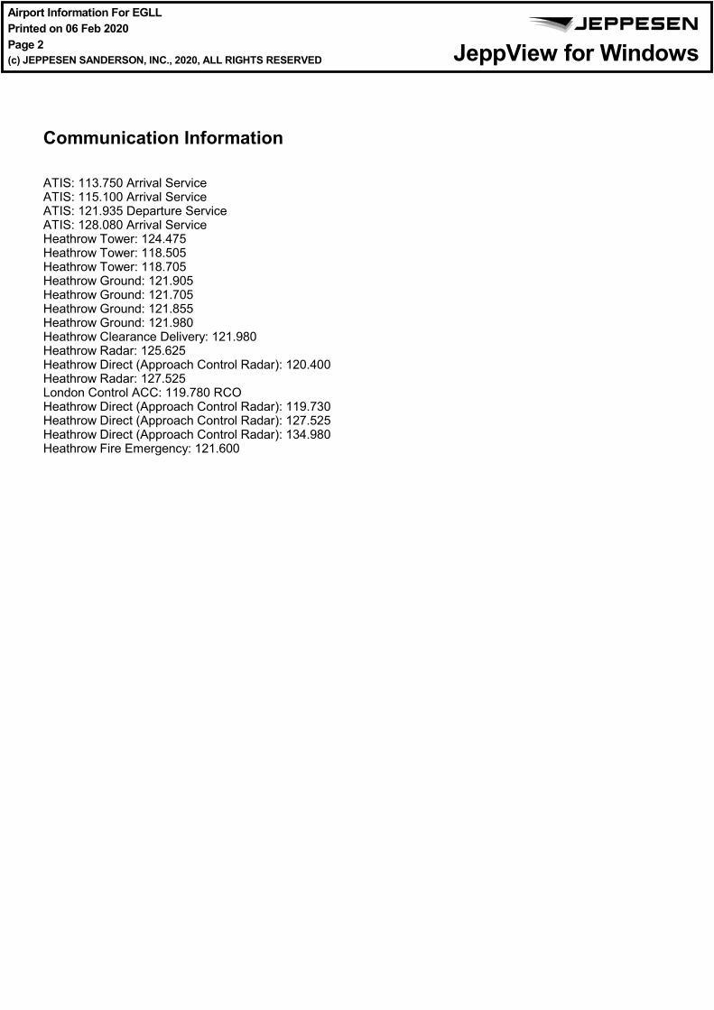
Communication Information
ATIS: 113.750 Arrival ServiceATIS: 115.100 Arrival ServiceATIS: 121.935 Departure ServiceATIS: 128.080 Arrival ServiceHeathrow Tower: 124.475Heathrow Tower: 118.505Heathrow Tower: 118.705Heathrow Ground: 121.905Heathrow Ground: 121.705Heathrow Ground: 121.855Heathrow Ground: 121.980Heathrow Clearance Delivery: 121.980Heathrow Radar: 125.625Heathrow Direct (Approach Control Radar): 120.400Heathrow Radar: 127.525London Control ACC: 119.780 RCOHeathrow Direct (Approach Control Radar): 119.730Heathrow Direct (Approach Control Radar): 127.525Heathrow Direct (Approach Control Radar): 134.980Heathrow Fire Emergency: 121.600
General Information
Location: LONDON GBRICAO/IATA: EGLL / LHRLat/Long: N51° 28.65', W000° 27.68'Elevation: 83 ft
Airport Use: PublicDaylight Savings: ObservedUTC Conversion: +0:00 = UTCMagnetic Variation: 0.0° E
Fuel Types: Jet A-1Repair Types: Major Airframe, Major EngineCustoms: YesAirport Type: IFRLanding Fee: YesControl Tower: YesJet Start Unit: NoLLWS Alert: NoBeacon: No
Sunrise: 0733 ZSunset: 1659 Z
Runway Information
Runway: 09LLength x Width: 12802 ft x 164 ftSurface Type: asphaltTDZ-Elev: 81 ftLighting: Edge, ALS, Centerline, TDZDisplaced Threshold: 1014 ft
Runway: 09RLength x Width: 12008 ft x 164 ftSurface Type: asphaltTDZ-Elev: 76 ftLighting: Edge, ALS, Centerline, TDZDisplaced Threshold: 1010 ft
Runway: 27LLength x Width: 12008 ft x 164 ftSurface Type: asphaltTDZ-Elev: 78 ftLighting: Edge, ALS, Centerline, TDZ
Runway: 27RLength x Width: 12802 ft x 164 ftSurface Type: asphaltTDZ-Elev: 79 ftLighting: Edge, ALS, Centerline, TDZ
Airport Information For EGLLPrinted on 06 Feb 2020Page 1(c) JEPPESEN SANDERSON, INC., 2020, ALL RIGHTS RESERVED
jep=JEPPESEN
JeppView for Windows
General Information
Location: LONDON GBRICAO/IATA: EGLL / LHRLat/Long: N51° 28.65', W000° 27.68'Elevation: 83 ft
Airport Use: PublicDaylight Savings: ObservedUTC Conversion: +0:00 = UTCMagnetic Variation: 0.0° E
Fuel Types: Jet A-1Repair Types: Major Airframe, Major EngineCustoms: YesAirport Type: IFRLanding Fee: YesControl Tower: YesJet Start Unit: NoLLWS Alert: NoBeacon: No
Sunrise: 0733 ZSunset: 1659 Z
Runway Information
Runway: 09LLength x Width: 12802 ft x 164 ftSurface Type: asphaltTDZ-Elev: 81 ftLighting: Edge, ALS, Centerline, TDZDisplaced Threshold: 1014 ft
Runway: 09RLength x Width: 12008 ft x 164 ftSurface Type: asphaltTDZ-Elev: 76 ftLighting: Edge, ALS, Centerline, TDZDisplaced Threshold: 1010 ft
Runway: 27LLength x Width: 12008 ft x 164 ftSurface Type: asphaltTDZ-Elev: 78 ftLighting: Edge, ALS, Centerline, TDZ
Runway: 27RLength x Width: 12802 ft x 164 ftSurface Type: asphaltTDZ-Elev: 79 ftLighting: Edge, ALS, Centerline, TDZ
Communication Information
ATIS: 113.750 Arrival ServiceATIS: 115.100 Arrival ServiceATIS: 121.935 Departure ServiceATIS: 128.080 Arrival ServiceHeathrow Tower: 124.475Heathrow Tower: 118.505Heathrow Tower: 118.705Heathrow Ground: 121.905Heathrow Ground: 121.705Heathrow Ground: 121.855Heathrow Ground: 121.980Heathrow Clearance Delivery: 121.980Heathrow Radar: 125.625Heathrow Direct (Approach Control Radar): 120.400Heathrow Radar: 127.525London Control ACC: 119.780 RCOHeathrow Direct (Approach Control Radar): 119.730Heathrow Direct (Approach Control Radar): 127.525Heathrow Direct (Approach Control Radar): 134.980Heathrow Fire Emergency: 121.600
Airport Information For EGLLPrinted on 06 Feb 2020Page 2(c) JEPPESEN SANDERSON, INC., 2020, ALL RIGHTS RESERVED
jep=JEPPESEN
JeppView for Windows

LONDON, UKEGLL/LHRHEATHROW .AIRPORT.BRIEFING.
+ JEPPESEN
1.1. ATIS
1.2. NOISE ABATEMENT PROCEDURES1.2.1. GENERAL
The following procedures may at any time be departed from to the extent neces-sary for avoiding immediate danger or for complying with ATC instructions.Every operator of ACFT using the APT shall ensure at all times that ACFT areoperated in a manner calculated to cause the least disturbance practicable inareas surrounding the APT.
1.2.2. PREFERENTIAL RWY SYSTEMWhen tailwind component is not greater than 5 KT on RWYs 27R/L, these RWYswill be used in preference to RWY 09R/L, provided the RWY surface is dry.Pilots asking for permission to use the RWY into the wind when RWYs 27R or 27Lare in use, should understand that their arrival or departure may be delayed.
1.2.3. REVERSE THRUSTAvoid use of reverse thrust between 2330-0600LT except for safety reasons.
1.2.4. RUN-UP TESTSRun-up tests are controlled in accordance with instructions issued by HeathrowAPT LTD.
1.2.5. NIGHTTIME RESTRICTIONSAny ACFT which has a noise classification greater than 95.9 EPNdB may not bescheduled to take off or land between 2330-0600LT.Any ACFT which has a noise classification greater than 98.9 EPNdB may not bescheduled to take off or land between 2300-0700LT.Any ACFT which has a noise classification greater than 98.9 EPNdB may nottakeoff between 2300-0700LT, except between 2300-2330LT when- it was scheduled to take off prior to 2300LT;- take-off was delayed for reasons beyond control of the ACFT operator;- APT authority has not given notice to the ACFT operator precluding take-off.Any ACFT may not take off or be scheduled to land between 2300-0700LT wherethe operator of that ACFT has not provided (prior to its take-off or prior to itsscheduled landing times as appropriate) sufficient information to enable the APTauthority to verify its noise classification.None of the provisions above shall apply to a take-off or landing which is made inan emergency consisting of an immediate danger to life or health, whether humanor animal.
1.3. LOW VISIBILITY PROCEDURES (LVP)1.3.1. GENERAL
During CAT II and III operations, special ATC LVPs will be applied. Pilots will beinformed when these procedures are in operation via ATIS or RTF. ATC LVPs willonly be applied when the RVR is less than 600m.
1.3.2. ARRIVAL- Surface Movement Guidance and Control System (SMGCS) is normally available
and all RWY exits will then be illuminated.Pilots should select the first convenient exit.
- Pilots are to delay the call "RWY vacated" until ACFT has completely passedthe end of the green/yellow colour-coded TWY centerline lights.
1.3.3. DEPARTUREThe ILS on the departure RWY will be turned off when the IRVR is greater than250m. Pilots requiring the ILS for departure when the IRVR is in the range 275m to550m must inform HEATHROW Delivery.
* D-ATIS Arrival 113.750 115.1 128.080* D-ATIS Departure 121.935 (Non-8.33kHz-equipped ACFT should contact
Heathrow Delivery.)
10-1P22 FEB 19 .Eff.28.Feb.
1. GENERAL
| JEPPESEN, 2006, 2018. ALL RIGHTS RESERVED.
Printed from JeppView for Windows 5.3.0.0 on 06 Feb 2020; Terminal chart data cycle 03-2020; Notice: After 20 Feb 2020, 0000Z, this chart may no longer be valid

LONDON, UKEGLL/LHRHEATHROW .AIRPORT.BRIEFING.
+ JEPPESEN
1.4. SURFACE MOVEMENT GUIDANCE AND CONTROL SYSTEMAPT is equipped with Mode S movement radar. Pilots must ensure that:ACFT transponder is set to transmit Mode S signals, and associated Mode A code,from the request for push-back or taxi, whichever is earlier and after landing,continuously until ACFT is fully parked on stand.After parking, Mode A code 2000 must be set before selecting OFF or STDBY.
1.5. RWY OPERATIONS1.5.1. RWY CROSSING PROCEDURE
After crossing RWY 09R/27L and having reported RWY vacated, the ACFT will beinstructed to revert to Ground for further clearance. In absence of further clear-ance it is essential that ACFT holds position when clear of RWY.
1.6. TAXI PROCEDURES1.6.1. GENERAL
Pilots who intend to execute a reduced engine taxi-out must report their intentionto delivery on first contact by data link or if possible by RT.In the apron areas minimum engine power shall be used as far as possible, and useof reverse thrust for maneuvering to and from a stand is not permitted.Whenever operationally and safely feasible, all ACFT are requested to shut downas many engines as possible while taxiing and holding on the ground, EXCEPT inthe following circumstances:a) By any ACFT that is required to cross an active arrival RWY;b) By any ACFT exiting T and turning West onto S, Link 44 and Link 42, due to jet
blast;c) By B777 variants in G and H due to jet blast.Pilots are to use the minimum power necessary when maneuvering on the TWYsystem. This is of particular importance when maneuvering in the aproncul-de-sacs, where jet blast can affect adjacent stands.Pilots are reminded of the extreme importance of maintaining a careful lookoutat all times and are at all times responsible for wingtip clearance, notwithstand-ing the TWY lighting system.Any ACFT with a CTOT should plan Reduced Engine Taxi to be ready for departureat CTOT -5 minutes.
1.6.2. RESTRICTIONSTWY Y between HANLI and TWY A is restricted to ACFT with a maximum size ofA321.Link 56 restricted to code D ACFT.
10-1P122 FEB 19 .Eff.28.Feb.
1. GENERAL
| JEPPESEN, 2006, 2019. ALL RIGHTS RESERVED.
Printed from JeppView for Windows 5.3.0.0 on 06 Feb 2020; Terminal chart data cycle 03-2020; Notice: After 20 Feb 2020, 0000Z, this chart may no longer be valid
LONDON, UKEGLL/LHRHEATHROW .AIRPORT.BRIEFING.
+ JEPPESEN
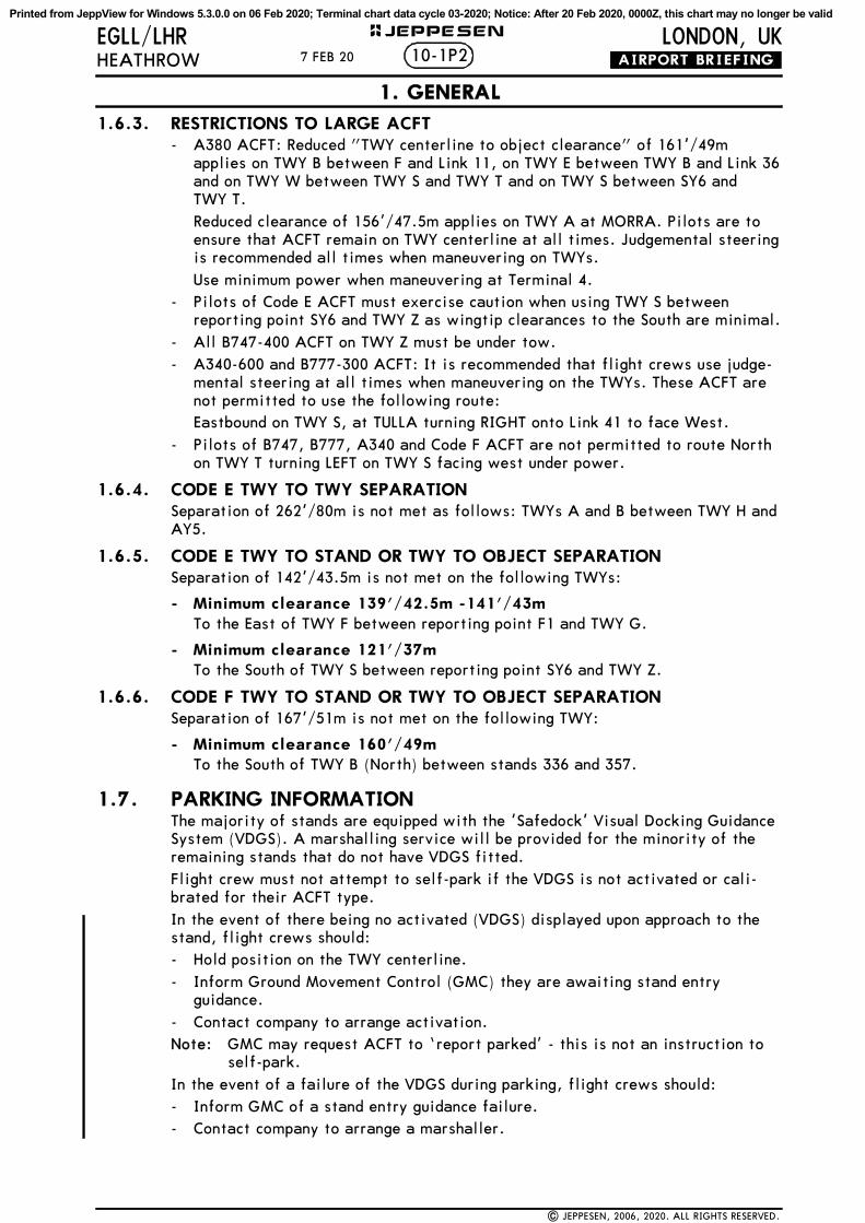
1.6.3. RESTRICTIONS TO LARGE ACFT- A380 ACFT: Reduced "TWY centerline to object clearance" of 161'/49m
applies on TWY B between F and Link 11, on TWY E between TWY B and Link 36and on TWY W between TWY S and TWY T and on TWY S between SY6 and TWY T.Reduced clearance of 156’/47.5m applies on TWY A at MORRA. Pilots are toensure that ACFT remain on TWY centerline at all times. Judgemental steeringis recommended all times when maneuvering on TWYs.Use minimum power when maneuvering at Terminal 4.
- Pilots of Code E ACFT must exercise caution when using TWY S betweenreporting point SY6 and TWY Z as wingtip clearances to the South are minimal.
- All B747-400 ACFT on TWY Z must be under tow.- A340-600 and B777-300 ACFT: It is recommended that flight crews use judge-
mental steering at all times when maneuvering on the TWYs. These ACFT arenot permitted to use the following route:Eastbound on TWY S, at TULLA turning RIGHT onto Link 41 to face West.
- Pilots of B747, B777, A340 and Code F ACFT are not permitted to route Northon TWY T turning LEFT on TWY S facing west under power.
1.6.4. CODE E TWY TO TWY SEPARATIONSeparation of 262'/80m is not met as follows: TWYs A and B between TWY H andAY5.
1.6.5. CODE E TWY TO STAND OR TWY TO OBJECT SEPARATIONSeparation of 142'/43.5m is not met on the following TWYs:
- Minimum clearance 139'/42.5m -141'/43mTo the East of TWY F between reporting point F1 and TWY G.
- Minimum clearance 121'/37m To the South of TWY S between reporting point SY6 and TWY Z.
1.6.6. CODE F TWY TO STAND OR TWY TO OBJECT SEPARATIONSeparation of 167'/51m is not met on the following TWY:
- Minimum clearance 160'/49m To the South of TWY B (North) between stands 336 and 357.
1.7. PARKING INFORMATIONThe majority of stands are equipped with the 'Safedock' Visual Docking GuidanceSystem (VDGS). A marshalling service will be provided for the minority of theremaining stands that do not have VDGS fitted.Flight crew must not attempt to self-park if the VDGS is not activated or cali-brated for their ACFT type.In the event of there being no activated (VDGS) displayed upon approach to thestand, flight crews should:- Hold position on the TWY centerline.- Inform Ground Movement Control (GMC) they are awaiting stand entry
guidance.- Contact company to arrange activation.Note: GMC may request ACFT to ‘report parked’ - this is not an instruction to
self-park.In the event of a failure of the VDGS during parking, flight crews should:- Inform GMC of a stand entry guidance failure.- Contact company to arrange a marshaller.
10-1P27 FEB 20
1. GENERAL
| JEPPESEN, 2006, 2020. ALL RIGHTS RESERVED.
Printed from JeppView for Windows 5.3.0.0 on 06 Feb 2020; Terminal chart data cycle 03-2020; Notice: After 20 Feb 2020, 0000Z, this chart may no longer be valid

LONDON, UKEGLL/LHRHEATHROW .AIRPORT.BRIEFING.
+ JEPPESEN
2.1. SPEED RESTRICTIONSPilots should typically expect the following speed restrictions to be enforced:- 220 KT from the holding facility during the initial approach phase;- 180 KT on base leg/closing heading to the final APCH;- Between 180 KT and 160 KT when established on the final APCH;and thereafter 160 KT to D4.0.Adherence to speeds assigned by ATC is mandatory.These speeds are applied for ATC separation purposes.In the event of a new (non-speed related) ATC clearance being issued (e.g. aninstruction to descend on ILS), pilots shall continue to maintain a previously allo-cated speed. All speed restrictions are to be flown as accurately as possible.ACFT unable to conform to these speeds should inform ATC and state what speedscan be used. In the interests of accurate spacing, pilots are requested to complywith speed adjustments as promptly as feasible within their own operational con-straints, advising ATC if circumstances necessitate a change of speed for ACFTperformance reasons.
2.2. NOISE ABATEMENT PROCEDURESThe following procedures may at any time be departed from to the extent neces-sary for avoiding immediate danger or for complying with ATC instructions. Every operator of ACFT using the APT shall ensure at all times that ACFT areoperated in a manner calculated to cause the least disturbance practicable inareas surrounding the APT. An ACFT approaching to land shall according to its ATC clearance minimize noisedisturbance by the use of continuous descent and low power, low drag operatingprocedures (see below).Where the use is not practicable, ACFT shall maintain an altitude as high aspossible.
Propeller-driven ACFT with MTOW above 5700kgs and jet ACFT:
ACFT approaching RWY 27L/R between 0600-2330LTand using the ILS shall not descend below 2500' (Heathrow QNH) on GS beforebeing established on LOC, nor thereafter fly below GS. ACFT approaching withoutILS assistance shall follow a descent path which will not result in its being at anytime lower than the approach path that would be followed by an ACFT using theILS GS, and shall follow a track to intercept the extended RWY centerline at orabove 2500'.ACFT approaching RWY 27L/R between 2330-0600LTand using the ILS shall not descend below 3000' (Heathrow QNH) on GS beforebeing established on LOC at not less than 10NM from touchdown, nor thereafterfly below GS. ACFT approaching without ILS assistance shall follow a descentpath which will not result in its being at any time lower than the approach paththat would be followed by an ACFT using the ILS GS, and shall follow a track tointercept the extended RWY centerline at or above 3000'.ACFT approaching RWY 09L/R between 0700-2300LTand using the ILS shall not descend below 2500' (Heathrow QNH) on GS beforebeing established on LOC, nor thereafter fly below GS. ACFT approaching withoutILS assistance shall follow a descent path which will not result in its being at anytime lower than the approach path that would be followed by an ACFT using theILS GS, and shall follow a track to intercept the extended RWY centerline at orabove 2500'.ACFT approaching RWY 09L/R between 2300-0700LTand using the ILS shall not descend below 3000' (Heathrow QNH) on GS beforebeing established on LOC at not less than 10NM from touchdown, nor thereafterfly below GS. ACFT approaching without ILS assistance shall follow a descentpath which will not result in its being at any time lower than the approach paththat would be followed by an ACFT using the ILS GS, and shall follow a track tointercept the extended RWY centerline at or above 3000'.
10-1P37 FEB 20
2. ARRIVAL
| JEPPESEN, 2006, 2015. ALL RIGHTS RESERVED.
Printed from JeppView for Windows 5.3.0.0 on 06 Feb 2020; Terminal chart data cycle 03-2020; Notice: After 20 Feb 2020, 0000Z, this chart may no longer be valid

LONDON, UKEGLL/LHRHEATHROW .AIRPORT.BRIEFING.
+ JEPPESEN
CONTINUOUS DESCENT APPROACH
Headings and flight levels/altitudes by ATC. ACFT will be radar-vectored. Anestimate of track distance to touchdown will be passed with descent clearance.Further distance information will be given between descent clearance and theintercept heading to the ILS LOC.On receipt of descent clearance, descend at the rate best suited to a continuousdescent so as to join the GS at the appropriate height for the distance withoutrecourse to level flight.
2.3. CAT II/III OPERATIONSRWYs 09L/27R and 09R/27L approved for CAT II/III operations, special aircrewand ACFT certification required.
2.4. RWY OPERATIONS2.4.1. MINIMUM RWY OCCUPANCY TIME
Pilots are reminded that rapid exit from the landing RWY enables ATC to applythe minimum spacing on final approach that will achieve maximum RWY utilisa-tion and will minimize the occurrence of go-arounds.Landing ACFT are to vacate expeditiously. All arrivals are to ensure that they arefully vacated before stopping.
2.4.2. RWY VACATION GUIDELINESACFT lands but cannot contact HEATHROW Ground due to RTF congestion:In this case the pilot should completely vacate the landing RWY and taxi into thefirst TWY available. The pilot should then hold position until contact with Groundcan be established.RWY 09L: Furthest preferred TWY for A380 ACFT is A5.RWY 09R: Furthest preferred TWY for A380 ACFT is S4E and N4E.RWY 27L: Furthest preferred TWY for A380 ACFT is S6 and N7.RWY 27R: Furthest preferred TWY for A380 ACFT is A11.
10-1P423 NOV 18 .Eff.6.Dec.
2. ARRIVAL
| JEPPESEN, 2006, 2018. ALL RIGHTS RESERVED.
Printed from JeppView for Windows 5.3.0.0 on 06 Feb 2020; Terminal chart data cycle 03-2020; Notice: After 20 Feb 2020, 0000Z, this chart may no longer be valid

LONDON, UKEGLL/LHRHEATHROW .AIRPORT.BRIEFING.
+ JEPPESEN
2.5. OTHER INFORMATION2.5.1. GENERAL
Warning: The possibility of building-induced turbulence and large windsheareffects may occur when landing on RWY 27R in strong southerly / south-westerly winds.
2.5.2 "LAND AFTER" PROCEDURENormally, only one ACFT is permitted to land or take-off on the RWY-in-use atany one time. However, when the traffic sequence is two successive landingACFT, the second one may be allowed to land before the first one has cleared theRWY-in-use, providing:- The RWY is long enough;- It is during daylight hours;- The second ACFT will be able to see the first ACFT clearly and continuously
until it is clear of the RWY;- The second ACFT has been warned. ATC will provide this warning by issuing the second ACFT with the instruction"Land after ... (first ACFT type)" in place of the usual instruction "Cleared toland". Responsibility for ensuring adequate separation between the two ACFTrests with the pilot of the second ACFT.
10-1P523 NOV 18 .Eff.6.Dec.
2. ARRIVAL
| JEPPESEN, 2006, 2011. ALL RIGHTS RESERVED.
Printed from JeppView for Windows 5.3.0.0 on 06 Feb 2020; Terminal chart data cycle 03-2020; Notice: After 20 Feb 2020, 0000Z, this chart may no longer be valid

LONDON, UKEGLL/LHRHEATHROW .AIRPORT.BRIEFING.
+ JEPPESEN
3.1. DE-ICINGAnnually, Heathrow publishes an ACFT De-icing Plan (HADIP). All Airline opera-tors should ensure that they have read and understood this document.During periods of high demand for de-icing, Heathrow activates the A-CDM "Win-ter Module" which includes ACFT de-icing rig allocation capability.In order to request de-icing, pilots should follow their company's standard proce-dure. In accordance with Heathrow's de-icing plan, operators will enter therequirement for de-icing into A-CDM, which will ensure that de-icing resourcesare allocated appropriately. If the ACFT is to be de-iced remotely, operatingcompanies will pass this information to pilots prior to push.When doors are closed and ready to commence de-icing on gate, pilots must callHeathrow Delivery stating "Ready for de-icing". This call must be made at+/- 5 minutes from TOBT.Once de-icing on the gate is complete, pilots should call Heathrow Deliveryagain, stating "De-icing complete, ready to push and start".Pilots who have been allocated a remote de-icing area should contact HeathrowDelivery, stating "Ready to push and start for remote de-icing".
3.2. START-UP AND PUSH-BACK PROCEDURES3.2.1. APT-COLLABORATIVE DECISION MAKING (A-CDM)
3.2.1.1. TARGET OFF-BLOCK TIME (TOBT)/TARGET START-UP APPROVAL TIME (TSAT) Pilots should take note of the TSAT which they receive from their airline opera-tor/ground handler or ATC and comply with it. If TOBT or TSAT can no longer be met, at any time, then TOBT must be updated byairline operator/ground handler.Pilot should ensure that the flight is ready to depart at TOBT +/-5 minutes.
3.2.1.2. START REQUEST - HEATHROW DELIVERYPilot should report ready to HEATHROW Delivery at TOBT +/-5 minutes.ATC will then approve start or in the case of a delay will advise the TSAT.- Pilots to monitor the frequency from this point, as TSAT can improve up to
TOBT.- Pilots will be informed of an ATC delay to TSAT in excess of 5 minutes.If at TOBT +5 minutes ATC have not received a start-up request the ACFT maylose its position in the sequence.- ATC will advise the pilot that a new TOBT is required.- The ACFT will not be allowed to depart until a valid TOBT is entered and
revised TSAT given and complied with.
3.2.1.3. REMOTE HOLDING REQUESTIf an airline operator is aware of a CTOT and wishes to take the delay on a TWYrather than on the stand, then they should contact the Tower supervisor via phoneto arrange it.In this instance, TSAT will be adjusted to allow ACFT to be transferred toHEATHROW Ground earlier for remote hold.
10-1P67 SEP 18
3. DEPARTURE
| JEPPESEN, 2006, 2016. ALL RIGHTS RESERVED.
Printed from JeppView for Windows 5.3.0.0 on 06 Feb 2020; Terminal chart data cycle 03-2020; Notice: After 20 Feb 2020, 0000Z, this chart may no longer be valid

LONDON, UKEGLL/LHRHEATHROW .AIRPORT.BRIEFING.
+ JEPPESEN
3.2.2. DATALINK DEPARTURE CLEARANCE (DCL)DCL via SITA or ARINC.DCL available from 25 minutes prior to EOBT to 15 minutes after EOBT. Clearancewill not be issued if requested later than 15 minutes after EOBT.Successful clearance must be accepted within 5 minutes after receipt or a"Revert to voice" message will be received. If the attempt to obtain a clearance is unsuccessful, the ACFT should revert toRTF. Regardless of clearance source, departing ACFT must report ACFT type,stand number, QNH and the identification letter of the received ATIS informationto HEATHROW Delivery when fully ready for push-back and start.In strong crosswind conditions (crosswind component above 35 KT), pilots arerequested to advise Ground Movement Planning, on start-up, of their ACFT cross-wind limitations. This is to enable better tactical planning at the RWY holdingpoint and a more efficient departure rate. In those conditions, this requirementwill be confirmed through ATIS broadcast and NOTAM (if sufficient time allows).
3.2.3. START-UPOn first contact with HEATHROW Delivery, pilots are to report ACFT type, standnumber, QNH and identification letter of received ATIS info.Between 0630-1400LT and between 1500-2200LT pilots of operators who havebeen briefed with regard to the correct phraseology may call for ATC clearance upto 15 minutes prior to being fully ready to push-back. All other operators must befully ready before calling on frequency.Pilots who wish to start engines on stand must request permission fromHEATHROW Ground not later than 5 minutes after being transferred fromDelivery.All jet ACFT are to advise ATC, if for any reason they are unable to accelerateafter noise abatement procedures to 250 KT.If within 30 minutes of a previously issued Calculated Take-off Time (CTOT) theflight is unable to comply with that CTOT, the pilot should advise ATC as soon aspossible. Pilots are advised that delays in excess of 10 minutes can be expectedat holding position. Sufficient time should be allowed for start, push-back andtaxi to take account of such a delay especially if required to comply with a Calcu-lated Take-off Time (CTOT).
3.2.4. PUSH-BACKFollowing push-back from cul-de-sac stands, all ACFT must pull forward to a min-imum of 328'/100m from the blast screen (indicated by a painted mark on theTWY centerline) before disconnecting the tug. Due to exhaust fume ingestionwithin the buildings at the end of all cul-de-sacs, engine start-up must be delayeduntil the ACFT has reached the 328'/100m mark. Pilot should be aware that, inorder to maximise capacity within the Kilo (S) cul-de-sac, push-back clearancesprovided by ATC may include reference to a numbered "Tug Release Point" TRP 1,TRP 2 or TRP 3, which should be passed to ground crew along with the clearance.Ground handlers will understand these clearances and perform the pushaccordingly.Before flight crew calls for push-back they must ensure that the tug driver is inthe tug, ready to push, and able to listen to the communication with ATC.Push-back/start clearance must be requested from HEATHROW Ground no laterthan 5 minutes after being transferred from Delivery.Push-back approval includes permission to start engines during push-back.Flight crews should only illuminate ACFT anti-collision lights following enginestart or push-back clearance from ATC.
10-1P77 SEP 18
3. DEPARTURE
| JEPPESEN, 2006, 2018. ALL RIGHTS RESERVED.
Printed from JeppView for Windows 5.3.0.0 on 06 Feb 2020; Terminal chart data cycle 03-2020; Notice: After 20 Feb 2020, 0000Z, this chart may no longer be valid

LONDON, UKEGLL/LHRHEATHROW .AIRPORT.BRIEFING.
+ JEPPESEN
3.3. NOISE ABATEMENT PROCEDURES3.3.1. GENERAL
The following procedures may at any time be departed from to the extent neces-sary for avoiding immediate danger or for complying with ATC instructions. Every operator of ACFT using the APT shall ensure at all times that ACFT areoperated in a manner calculated to cause the least disturbance practicable inareas surrounding the APT. After take-off operate ACFT so that it is at or above 1090' at 6.5km from startof roll as measured along the departure track and so that it will not cause morethan:- 94 dBA between 0700-2300LT;- 89 dBA between 2300-2330LT and between 0600-0700LT;- 87 dBA between 2330-0600LT;at any noise monitoring terminal. Jet ACFT maintain a minimum climb gradient of243' per NM (4%) to at least 4000' to ensure progressively decreasing noise lev-els at points on the ground under the flight path beyond the monitoring terminal.Noise preferential routing procedures applicable for all jet ACFT and other ACFTwith MTWA of more than 5700kg (between 0600-2330LT of more than 17000kg andexcept any Dash 7 ACFT) are depicted on London Heathrow SID charts and on page10-4.
3.3.2. NOISE QUOTA SYSTEM DURING NIGHT (2300-0700LT)Main restrictions are as follows:- Night Period (2300-0700LT);- Night Quota Period (2330-0600LT).The quota count is to be calculated based on the noise classification for the ACFTas follows:
3.4. SPEED RESTRICTIONSWhen ATC removes MAX 250 KT speed restriction below FL 100 by the phrase "NoATC speed restriction", this must not be interpreted as removing the responsibil-itiy to adhere to any speed/power limitations due to noise abatement procedures.If a pilot can anticipate to be unable to comply with speed restriction, state min-imum speed acceptable when requesting start-up.
Noise Classification (EPNdB) QUOTA Count
less than 81 081 - 83.9 0.12584 - 86.9 0.2587 - 89.9 0.590 - 92.9 193 - 95.9 296 - 98.9 499 - 101.9 8
more than 101.9 16
10-1P826 OCT 18 .Eff.28.Oct.0200Z.
3. DEPARTURE
| JEPPESEN, 2006, 2018. ALL RIGHTS RESERVED.
Printed from JeppView for Windows 5.3.0.0 on 06 Feb 2020; Terminal chart data cycle 03-2020; Notice: After 20 Feb 2020, 0000Z, this chart may no longer be valid

LONDON, UKEGLL/LHRHEATHROW .AIRPORT.BRIEFING.
+ JEPPESEN
3.5. RWY OPERATIONS3.5.1. MINIMUM RWY OCCUPANCY TIME
On receipt of line-up clearance, pilots should ensure, commensurate with safetyand standard operating procedures, that they are able to taxi into the correctposition at the hold and line up on the RWY as soon as the preceding ACFT hascommenced its take-off roll.Pilots in receipt of a conditional line-up clearance on a preceding departing ACFT(for example; "ABC123 behind the departing Sky Train A330, line up RWY 27Lbehind") should remain behind the subject ACFT but may cross the RWY holdingpoint (subject to there being no illuminated red stop bar) and enter the RWY uponreceipt of the clearance. There is no requirement for the subject ACFT to havecommenced its take-off roll before entering the RWY. Pilots must be aware thatthere may be a blast hazard as the ACFT on the RWY applies power.Pilots in receipt of a conditional line-up clearance on a preceding arriving ACFT(for example; "ABC123 behind the landing Sky Train A330, line up RWY 27Lbehind") may cross the RWY holding point (subject to there being no illuminatedred stop bar) as soon as the landing ACFT has passed the RWY entry point.Pilots who require to back-track the RWY (including line-up from N2W onto RWY27L) must notify ATC prior to arrival at the holding point.Pilots are advised that there is an increased risk of RWY Incursions when holdingat N11 and NB11. Pilots may mistakenly believe that when on reaching the frontof the queue, they have been given permission to line up in turn. Pilots are to beextra vigilant as to whether they have received a line-up clearance from ATC andseek confirmation where there is doubt.Whenever possible, cockpit checks must be completed prior to line-up, and anychecks requiring completion whilst on the RWY should be kept to the minimumrequired. Pilots should ensure that they are able to commence the take-off rollimmediately after take-off clearance is issued.Pilots not able to comply with these requirements should notify ATC as soon aspossible once transferred to HEATHROW Tower.
3.5.2. RWY HOLDING AREASIn promulgated holding areas, ATC may require ACFT to pass each other. Avoid-ance of other ACFT is the responsibility of the flight crew involved. If doubtexists as to whether other ACFT can be safely overtaken, ACFT must stop, adviseATC and request alternative instructions.
3.6. TAXI RESTRICTIONSFlight crews must not enter the RWY unless verbal clearance has been receivedfrom ATC and the red stop bar has been extinguished.If the red stop bar lights are extinguished but no verbal clearance has beenreceived from ATC, flight crews must wait for verbal clearance before enteringthe RWY.
10-1P926 OCT 18 .Eff.28.Oct.0200Z.
3. DEPARTURE
| JEPPESEN, 2016, 2018. ALL RIGHTS RESERVED.
Printed from JeppView for Windows 5.3.0.0 on 06 Feb 2020; Terminal chart data cycle 03-2020; Notice: After 20 Feb 2020, 0000Z, this chart may no longer be valid

LAM VOR DMELAMBOURNE
BPK VOR DMEBROOKMANS PARK
LON VOR DMELONDON
OCK VOR DMEOCKHAM
BNN VOR DMEBOVINGDON
CHT NDBCHILTERN
EPM NDBEPSOM
HEN NDBHENTON
LCY LCTR
RDL NDB
WOODLEYWOD NDB
BLK NDB
FOS NDB
BIGGIN
BIGVOR DME
180^
090^
030^
150^210^
330^
300^
240^
060^
D20
D10
0^
D20
D10 D10
D20
D30
D30
D30
LONDONHeathrow
1020
3040
500
515
2535
455
360^
180^
270^
090^
1800
2000
2100
2300
2200
2100
2000
- within 5 NM 12- within the sector 15 NM ahead of and within 20^ either side of the aircraft's track.
13 NM 2or 10 NM when the aircraft is within 15 NM of the radar antennae.
Continue visually or by means of an appropriate approved final approachaid. If not possible proceed to CHT or last assigned level if higher.Continue visually or by means of an appropriate approved final approachaid. If not possible proceed to EPM or last assigned level if higher.
Apt Elev
EGLL/LHR10-1R .RADAR.MINIMUM.ALTITUDES.
HEATHROW Radar
HEATHROWLONDON, UKJEPPESEN
The minimum altitude to be allocated by the radar controller will be either the Minimum Sector Altitude or 1000 above any fixed obstacles:
1900
1600
2100
2300
1600
2100
of the aircraft and
.Eff.31.Jan.
| JEPPESEN, 2011, 2019. ALL RIGHTS RESERVED.
25 JAN 19
*125.625 127.525 83Alt Set: hPaTrans level: By ATC Trans alt: 6000
Communication.
51-00
51-30
00-3001-00 00-00
RWYPROCEDURE LOSS OF COMMUNICATION PROCEDURE
INITIALAPPROACH
INTERMEDIATEAND FINALAPPROACH
OUTSIDE THE DESIGNATED RADAR MINIMUM ALTITUDE AREA
09L/27R
In all cases where the acft returns to the holding facility the procedures to be adopted are the Approach Radio Failure Procedures on charts 11-5/11-6.
09R/27L
09L/27R
09R/27L
CHANGES:
Continue visually or by means of an appropriate approved final approachaid. If not possible follow the Missed Approach Procedure to CHT.
Continue visually or by means of an appropriate approved final approach aid. If not possible follow the Missed Approach Procedure to EPM.
1184
Printed from JeppView for Windows 5.3.0.0 on 06 Feb 2020; Terminal chart data cycle 03-2020; Notice: After 20 Feb 2020, 0000Z, this chart may no longer be valid

NORTHOLT
EGW
U
SHOREHAM
EGKA
BIG
GIN
HIL
LEGKB
LONDON
Gatw
ick
EGKK
LONDON
EGLC
FARNBOROUGH
EGLF
SOUTHEND
EGMC
LYDD
EGMD
City
2300
RP
A
FL1
80
FL7
0
EGLL/LHRHEATHROW
LONDON, UK
1.
RNA
V 5
.2.
Sta
ndar
d ro
utes
may
be
vari
ed b
y A
TC.
3. A
CFT
may
be
inst
ruct
ed '
dire
ct t
o' (
wpt
)fo
llow
ing
RAD
AR
vect
orin
g.
Alt
Set
: hP
aTr
ans
leve
l: B
y A
TC*
D-A
TIS
113.
750
115.
112
8.08
0
Apt
Ele
v
83
JEPPESEN
WA
RNIN
G
| JEPPESEN, 2019. ALL RIGHTS RESERVED.
.RNAV.STAR.
DESCENT P
LANNIN
GPi
lots
sho
uld
plan
for
pos
sibl
e de
scen
t cl
eara
nce
ACTUA
L DESCENT C
LEA
RA
NCE W
ILL
BE A
SDIR
ECTED B
Y A
TC.
as f
ollo
ws:
1 NOV 19 .Eff.7.Nov.10-2
Do
not
proc
eed
beyo
ndBIG
VO
Rw
itho
ut A
TC c
lear
ance
.
FL18
0 by
ETV
AX,
FL70
by
BIG
VO
R.
ALE
SO
RO
TNO 31
5^24
.0
ETVA
X9.
5
MA
X F
L240
MH
A F
L150
TIG
ER
8.5
LLE~1
316^
10.0
MA
X F
L150
MH
A F
L70
123^
303^
12.0
010
2030
4050
10
136^
316^
HO
LDIN
G O
VER
TIG
ER
115.
1 BIG
BIG
GIN
BIG
D
1305
R136
RNAV STARs established & transferred.
22
35
35
23
24
23
51-00
51-30
00-00
00-30
00-30
01-00
01-30
MA
X 2
50 K
T
MA
X 2
20 K
T
CHANGES:
RO
UTIN
G
ALESO
1H [ALES1
H]
RNAV (DME/
DME or G
NSS) ARR
IVAL
NO
T T
O S
CA
LE
ALE
SO -
RO
TNO
- E
TVA
X (
FL18
0) -
TIG
ER -
LLE
~1 (
K25
0-)
-BIG
VO
R (K
220-
; FL
70).
H
Printed from JeppView for Windows 5.3.0.0 on 06 Feb 2020; Terminal chart data cycle 03-2020; Notice: After 20 Feb 2020, 0000Z, this chart may no longer be valid

NORTHOLTEGWU
LONDONLutonEGGW
FARNBOROUGHEGLF
BENSONEGUB
ODIHAMEGVO
2300
RA
P
FL70
FL140
EGLL/LHRHEATHROW
LONDON, UK
Apt Elev
83*D-ATIS
113.750 115.1 128.0801. RNAV 5.2. Standard routes may be varied by ATC.3. ACFT may be instructed 'direct to' (wpt)
following RADAR vectoring.
Alt Set: hPaTrans level: By ATC
149^
115.3 OCKDO C K
OCKHAM
JEPPESEN
510
1520
2530
3540
450
5
Do not proceed beyondOCK
without ATC clearance.
WARNING
MHA FL70MAX FL150
| JEPPESEN, 2019. ALL RIGHTS RESERVED.
.RNAV.STAR.
1
1 RNAV STAR TOBID 1X is an overload procedureto be used only when instructed by ATC.Not to be used for flight planning purposes.
NIGIT
LLW~3
091^15.2
329^
12.0
TOBID
352 WODWOODLEY
WOD
155^
50.8TO
BID
1X
LLW~2119^6.5
12.0
R299R271
DESCENT PLANNINGPilots should plan for possible descent clearance
ACTUAL DESCENT CLEARANCE WILL BE ASDIRECTED BY ATC.
as follows:
FL70 by OCK.BEDEK 1H:
TOBID 1X: FL70 by OCK.
1 NOV 19 .Eff.7.Nov.
BEDEK
BEDEK 1H15.0
103^
FL140 by BEDEK
10-2A
Chart reindexed.
1184
24 2351-30
01-00 00-30
MAX 220 KT
MAX 250 KT
MAX 250 KT
CHANGES:
DURING PERIODS OF CONGESTION TRAFFIC MAYBE ROUTED VIA OCK 1Z AS DIRECTED BY ATC
NOT TO BE USED FOR FLIGHT PLANNING PURPOSES
NOT TO SCALE
ROUTINGSTAR
BEDEK 1H
TOBID 1X TOBID - WOD - LLW02 (K250-) - OCK (K220-; FL70).
BEDEK 1H [BEDE1H]TOBID 1X [TOBI1X]
NOT TO SCALE
BEDEK (FL140) - NIGIT - LLW03 (K250-) - OCK (K220-; FL70).
RNAV (DME/DME or GNSS) ARRIVALS
Printed from JeppView for Windows 5.3.0.0 on 06 Feb 2020; Terminal chart data cycle 03-2020; Notice: After 20 Feb 2020, 0000Z, this chart may no longer be valid

51-30
00-0000-30
NORTHOLTEGWU
BIGGIN HILLEGKB
LONDON
EGLCCity
LONDONGatwickEGKK
2300RP
A
FL70
EGLL/LHRHEATHROW
LONDON, UK
Apt Elev
83*D-ATIS
113.750 115.1 128.0801. RNAV 5.2. Standard routes may be varied by ATC.3. Acft may be instructed 'direct to' (wpt)
following RADAR vectoring.
Alt Set: hPaTrans level: By ATC
DORKI
254^
11.7
285^
7.1R105
149^329^
115.3 OCKD 115.1 BIG
D
O C KOCKHAM B I G
BIGGIN
JEPPESEN
510
1520
2530
3540
450
5
1305
Do not proceed beyondOCK
without ATC clearance.
WARNING
DESCENT PLANNINGPilots should plan for possible descent clearance
ACTUAL DESCENT CLEARANCE WILL BE ASDIRECTED BY ATC.
as follows:FL70 by OCK.
MHA FL70MAX FL150
| JEPPESEN, 2019. ALL RIGHTS RESERVED.
.RNAV.STAR.
STAR IS TO FACILITATE THE TRANSFER OFTRAFFIC BETWEEN TERMINAL HOLDING FACILITIES
10-2B
Chart reindexed.
1 NOV 19 .Eff.7.Nov.
23 24MAX 250 KT
MAX 220 KT
CHANGES:
ROUTING
AND ARE FOR USE ONLY AS DIRECTED BY ATCNOT TO BE USED FOR FLIGHT PLANNING PURPOSESDURING PERIODS OF CONGESTION TRAFFIC MAYBE ROUTED VIA OCK 1Z AS DIRECTED BY ATC
BIG 1Z
BIG (K250-) - DORKI - OCK (K220-; FL70).
RNAV (DME/DME or GNSS) ARRIVAL
Printed from JeppView for Windows 5.3.0.0 on 06 Feb 2020; Terminal chart data cycle 03-2020; Notice: After 20 Feb 2020, 0000Z, this chart may no longer be valid

COVENTRY
EGBE
GLOUCESTERSHIR
EEGBJ
LONDON
Luto
nEGGW
OXFORD
EGTK
BENSON
EGUB
FAIR
FORD
EGVA
BRIZ
E N
ORTON
EGVN
NORTHOLT
EGW
U
-Ab
2300
RA
P
FL1
80
FL1
50
FL7
0
EGLL/LHRHEATHROW
LONDON, UK10-2C
83A
pt E
lev
1.
RNA
V 1
.2.
Sta
ndar
d ro
utes
may
be
vari
ed b
y A
TC.
1 NOV 19 .Eff.7.Nov.
3. A
CFT
may
be
inst
ruct
ed '
dire
ct t
o' (
wpt
)fo
llow
ing
RAD
AR
vect
orin
g.
WA
RNIN
G
Do
not
proc
eed
beyo
ndBN
N V
OR
wit
hout
ATC
cle
aran
ce.
DESCENT P
LANNIN
GPi
lots
sho
uld
plan
for
pos
sibl
e de
scen
t cl
eara
nce
ACTUA
L DESCENT C
LEA
RA
NCE W
ILL
BE A
SDIR
ECTED B
Y A
TC.
as f
ollo
ws:
Alt
Set
: hP
aTr
ans
leve
l: B
y A
TC
.RNAV.STAR.
| JEPPESEN, 2019. ALL RIGHTS RESERVED.
113.
750
115.
112
8.08
0
*D
-ATI
S
FL18
0 by
FIT
BO
,FL
150
by S
OPI
T,FL
70 b
y BN
N V
OR.
MA
X F
L290
MHA
FL1
80
316^
136^
FIT
BO
SO
PIT
108^
50.5
MA
X F
L150
MHA
FL9
0
009^
189^
140^
8.3
MA
X F
L150
MHA
FL7
011
6^17
.2
335
WCO
WES
TCO
TT
WC
O11
3.75
BN
NBO
VIN
GD
ON
BNN
D
1750
JEPPESEN
010
2030
4050
10
R296
297^
117^
HO
LDIN
G O
VER
BNN V
OR
37
24
23
37
26
51-30
52-00
02-00
02-30
01-00
01-30
00-00
00-30
UNLE
SS O
THERW
ISE A
UTHO
RIZ
ED
.SPEED
:M
AX 2
50 K
T B
ELO
W F
L100
MA
X 2
20 K
TM
AX 2
20 K
T
CHANGES:
RO
UTIN
G
FITB
O 1
H [FITB
1H]
RNAV (DME/DME or G
NSS) ARR
IVAL
NOT
TO B
E USED FOR
FLIGHT
PLANNING P
URP
OSES
FITB
O (
FL18
0) -
SO
PIT
(FL1
50)
- W
CO
ND
B (
K22
0-)
- BN
N V
OR
(K22
0-;
FL70
).
RNAV STARs established & transferred.
H
Printed from JeppView for Windows 5.3.0.0 on 06 Feb 2020; Terminal chart data cycle 03-2020; Notice: After 20 Feb 2020, 0000Z, this chart may no longer be valid

NORTHOLTEGWU
FARNBOROUGHEGLF
ODIHAMEGVO
2300
RPA
FL70
FL130
EGLL/LHRHEATHROW
LONDON, UK
Apt Elev
83*D-ATIS
113.750 115.1 128.080
.Eff.7.Nov.
1. RNAV 5.2. Standard routes may be varied by ATC.
1 NOV 19 10-2C1
3. Acft may be instructed 'direct to' (wpt)following RADAR vectoring.
Alt Set: hPaTrans level: By ATC
149^329^
115.3 OCKDO C KOCKHAM
JEPPESEN
510
1520
2530
3540
450
5
Do not proceed beyondOCK
without ATC clearance.
WARNING
DESCENT PLANNINGPilots should plan for possible descent clearance
ACTUAL DESCENT CLEARANCE WILL BE ASDIRECTED BY ATC.
as follows:
FL70 by OCK.
MHA FL70MAX FL150
| JEPPESEN, 2019. ALL RIGHTS RESERVED.
.RNAV.STAR.
HAZEL
048^
R229
LLS01
049^
15.1
12.0
FL130 by HAZEL.
Chart reindexed.
1225
23 22
24
23
51-00
51-30
01-00 00-30
MAX 220 KT
MAX 250 KT
CHANGES:
ROUTING
DURING PERIODS OF CONGESTION TRAFFIC MAYBE ROUTED VIA OCK 1Z AS DIRECTED BY ATC
NOT TO BE USED FOR FLIGHT PLANNING PURPOSES
HAZEL 1H [HAZE1H]
HAZEL (FL130) - LLS01 (K250-) - OCK (K220-; FL70).
RNAV (DME/DME or GNSS) ARRIVAL
Printed from JeppView for Windows 5.3.0.0 on 06 Feb 2020; Terminal chart data cycle 03-2020; Notice: After 20 Feb 2020, 0000Z, this chart may no longer be valid

NORTHOLT
EGW
U
EGKBLONDON
EGLC
BIG
GIN
HIL
L
City
2300
RAP
FL7
0
EGLL/LHRHEATHROW
LONDON, UK
*D
-ATI
S
10-2C2
113.
750
115.
112
8.08
083
Apt
Ele
v1.
RNA
V 5
.2.
Sta
ndar
d ro
utes
may
be
vari
ed b
y A
TC.
1 NOV 19 .Eff.7.Nov.
3. A
CFT
may
be
inst
ruct
ed '
dire
ct t
o' (
wpt
)fo
llow
ing
RAD
AR
vect
orin
g.
WA
RNIN
G
Do
not
proc
eed
beyo
ndBIG
VO
Rw
itho
ut A
TC c
lear
ance
.
DESCENT P
LANNIN
GPi
lots
sho
uld
plan
for
pos
sibl
e de
scen
t cl
eara
nce
ACTUA
L DESCENT C
LEA
RA
NCE W
ILL
BE A
SDIR
ECTED B
Y A
TC.
as f
ollo
ws:
FL70
by
BIG
VO
R.
HIL
LY
170^19.0
LAM 1X
MA
X F
L150
MH
A F
L7012
3^
303^
115.
1 BIG
BIG
GIN
BIG
D
TA
NET
235^
15.1
TANET
1Z
LLE~2
275^
9.2
12.0
Alt
Set
: hP
aTr
ans
leve
l: B
y A
TC
.RNAV.STAR.
| JEPPESEN, 2019. ALL RIGHTS RESERVED.
R055
117.
3 D
ETD
ETLI
NG
DET
D
115.6
LA
MLA
MBO
URN
E
LAM
D
510
1520
2530
3540
450
5
R123
1305
R095
JEPPESEN
23
24
51-30
00-00
00-30
00-30
01-00
MA
X 2
20 K
T
MA
X 2
50 K
T
MA
X220 K
T
MA
X 2
50 K
TRN
AV (DME/
DME or G
NSS) ARR
IVALS
TANET
1Z [TA
NE1
Z]
TO B
E USED O
NLY
WHEN
INST
RUCTE
D B
Y A
TCNOT
TO B
E USED FOR
FLIGHT
PLANNING P
URP
OSES
OVER
LOAD STA
RS
CHANGES:
RO
UTIN
GSTA
R
TA
NET 1
Z
LAM
1X
TAN
ET -
DET
VO
R -
LLE~
2 (K
250-
) -
BIG
VO
R(K
220-
; FL
70).
LAM 1
X [LA
M1X
]
New chart (RNAV STARs established).
LAM
VO
R (K
250-
) -
HIL
LY (
K22
0-),
the
n tu
rnRI
GHT,
303
^ tr
ack
to B
IG V
OR
(K22
0-;
FL70
).
Printed from JeppView for Windows 5.3.0.0 on 06 Feb 2020; Terminal chart data cycle 03-2020; Notice: After 20 Feb 2020, 0000Z, this chart may no longer be valid

NORTHOLTEGWU
BIGGIN HILLEGKB
LONDON
EGLCCity
LONDONGatwickEGKK
51-30
00-0000-30
23 24
2300RP
A
FL70
EGLL/LHRHEATHROW
LONDON, UK
Apt Elev
83*D-ATIS
113.750 115.1 128.0801. RNAV 5.2. Standard routes may be varied by ATC.
10-2D
Alt Set: hPaTrans level: By ATC
3. ACFT may be instructed 'direct to' (wpt)following RADAR vectoring.
DORKI285^
7.1R105
149^329^
115.3 OCKDO C K
OCKHAM
JEPPESEN
510
1520
2530
3540
450
5
1305
Do not proceed beyondOCK
without ATC clearance.
WARNING
DESCENT PLANNINGPilots should plan for possible descent clearance
ACTUAL DESCENT CLEARANCE WILL BE ASDIRECTED BY ATC.
as follows:FL70 by OCK.
MHA FL70MAX FL150
| JEPPESEN, 2019. ALL RIGHTS RESERVED.
115.6 LAMLAMBOURNE
LAMD215^
27.2
.RNAV.STAR.
STAR IS TO FACILITATE THE TRANSFER OFTRAFFIC BETWEEN TERMINAL HOLDING FACILITIES
1 NOV 19 .Eff.7.Nov.
Chart reindexed.
MAX 250 KT
MAX 220 KT
CHANGES:
ROUTING
LAM (K250-) - DORKI - OCK (K220-; FL70).
AND ARE FOR USE ONLY AS DIRECTED BY ATCNOT TO BE USED FOR FLIGHT PLANNING PURPOSESDURING PERIODS OF CONGESTION TRAFFIC MAYBE ROUTED VIA OCK 1Z AS DIRECTED BY ATC
LAM 1YRNAV (DME/DME or GNSS) ARRIVAL
Printed from JeppView for Windows 5.3.0.0 on 06 Feb 2020; Terminal chart data cycle 03-2020; Notice: After 20 Feb 2020, 0000Z, this chart may no longer be valid

NORTHOLTEGWU
BIGGIN HILLEGKB
LONDONGatwickEGKK
LONDON
EGLCCity
2300RP
AFL70
EGLL/LHRHEATHROW
LONDON, UK
Apt Elev
83*D-ATIS
113.750 115.1 128.080
.Eff.7.Nov.
1. RNAV 5.2. Standard routes may be varied by ATC.
1 NOV 19 10-2D1
Chart reindexed.
3. Acft may be instructed 'direct to' (wpt)following RADAR vectoring.
Alt Set: hPaTrans level: By ATC
JEPPESEN
510
1520
2530
3540
450
5
Do not proceed beyondBIG
without ATC clearance.
WARNING
DESCENT PLANNINGPilots should plan for possible descent clearance
ACTUAL DESCENT CLEARANCE WILL BE ASDIRECTED BY ATC.
as follows:
| JEPPESEN, 2019. ALL RIGHTS RESERVED.
.RNAV.STAR.
DORKI
104^ 7.1
HILLY
080^
19.5
303^
115.1 BIGBIGGIN
BIGD
115.3 OCKOCKHAM
OCKD
R123
5.6
FL70 by BIG.
BIG
303^
123^
MHA FL70
HOLDING OVER
MAX FL150
1305
22
35
23
24
51-00
51-30
00-00
00-30
MAX 250 KT
MAX 220 KT
MAX 220 KT
CHANGES:
ROUTING
OCK 1Z
OCK - DORKI (K250-) - HILLY (K220-), turn RIGHT, 303^ track to BIG (K220-; FL70).
RNAV (DME/DME or GNSS) ARRIVAL
H
Printed from JeppView for Windows 5.3.0.0 on 06 Feb 2020; Terminal chart data cycle 03-2020; Notice: After 20 Feb 2020, 0000Z, this chart may no longer be valid

GLOUCESTERSHIR
EEGBJ
BOSCOMBE D
OW
NEGDM
YEOVIL
TON
EGDY
LONDON
Luto
nEGGW
YEOVIL
Westland
EGHG
BOURNEMOUTH
EGHH
SOUTHAMPTON
EGHI
SHOREHAM
EGKA
BIG
GIN
HIL
LEGKB
LONDON
Gatw
ick
EGKK
FARNBOROUGH
EGLF
OXFORD
EGTK BENSON
EGUB
FAIR
FORD
Fairfo
rd A
bEGVA
BRIZ
E N
ORTON
EGVN
ODIH
AM
EGVO
MID
DLE W
ALLOP
EGVP
NORTHOLT
EGW
U
2300
RPA
FL7
0
FL2
70
FL2
10
FL1
30
Apt
Ele
v*D
-ATI
S
113.
750
1
15.1
128.
080
83
LONDON, UK
17 M
AY 1
9.Eff.23.May.
OTM
ET
BIL
NI
SO
KDU
NEDUL
BEG
TO
HA
ZEL
LLS01
149^
329^
JEPPESEN
Alt
Set
: hP
a Tr
ans
leve
l: B
y A
TC
1.
RNA
V 1
.2.
RNA
V (
DM
E/DM
E o
r G
NSS).
3. S
tand
ard
rout
es m
ay b
e va
ried
by
ATC
.4.
ACFT
may
be
inst
ruct
ed '
dire
ct t
o' (
wpt
) fo
llow
ing
RA
DA
R ve
ctor
ing. RNAV A
RRIV
AL
DURING P
ERIODS
OF CONGESTION
TRAFFIC M
AY B
E RO
UTE
D V
IA O
CK 1
ZAS DIREC
TED B
Y A
TCNOT
FOR
FLIGHT
PLANNING P
URP
OSES
.RNAV.STAR.
HO
LDIN
G O
VER
BIL
NI
By
ATC
MA
X F
L300
MH
A F
L200
287^
107^
094^
089^
064^
033^
048^
18.7
18.3
13.2
17.4
15.1
12.0
01020304050 10
Air
craf
t w
ill
be i
nstr
ucte
dby
ATC
to
fly
the
appr
op-
riat
e FL
.
1
120
03
115.
3 O
CK
OC
KD
OCKH
AM
MH
A F
L70
R229
049^
23
23
22
31
24
23
24
50-30
51-00
51-30
02-00
02-30
01-00
01-30
00-00
00-30
00-30
MA
X 2
20 K
T
MA
X 2
50 K
T
MA
X 2
50 K
T B
ELO
W F
L100
.SPEED
:UNLE
SS O
THERW
ISE A
UTHO
RIZ
ED
EGLL/LHR
HEA
THRO
W
CHA
NG
ES:
RO
UTIN
G
OTM
ET 1
H [OTM
E1H]
DESCENT P
LANNIN
GPi
lots
sho
uld
plan
for
pos
sibl
e de
scen
t cl
eara
nce
as f
ollo
ws:
ACTUA
L DESCENT C
LEA
RA
NCE W
ILL
BE A
SDIR
ECTED B
Y A
TC.
FL27
0 by
OTM
ET,
FL21
0 by
NED
UL,
FL13
0 by
HA
ZEL,
FL70
by
OCK
WA
RNIN
GD
o no
t pr
ocee
d be
yond
OCK
wit
hout
ATC
cle
aran
ce.
OTM
ET (
FL27
0) -
SO
KD
U -
NED
UL
(FL2
10)
- BEG
TO -
HA
ZEL
(FL1
30)
- LL
S01
(K25
0-)
- O
CK (
K22
0-;
FL70
).
Cha
rt r
eind
exed
.
10-2
E
| J
EPPE
SEN
, 20
19.
ALL
RIG
HTS
RES
ERVED
.
H
Printed from JeppView for Windows 5.3.0.0 on 06 Feb 2020; Terminal chart data cycle 03-2020; Notice: After 20 Feb 2020, 0000Z, this chart may no longer be valid

BOURNEMOUTH
EGHH
SOUTHAMPTON
EGHI
SHOREHAM
EGKALONDON
Gatw
ick
EGKK
FARNBOROUGH
EGLF
BENSON
EGUB
FAIR
FORD
Fairfo
rd A
bEGVA
BRIZ
E N
ORTON
EGVN
ODIH
AM
EGVO
MID
DLE W
ALLOP
EGVP
NORTHOLT
EGW
U
BOSCOMBE D
OW
NEGDM
2300
RPA
FL1
30
FL7
0
Apt
Ele
v*D
-ATI
S
113.
750
1
15.1
128.
080
83
LONDON, UK
.Eff.7.Nov.
1 N
OV 1
9
RO
XO
GDO
MUT
AM
TO
DKA
THY
BEG
TO
HA
ZEL
LLS01
149^
329^
048^15
.1
12.0
Alt
Set
: hP
a Tr
ans
leve
l: B
y A
TC
2. S
tand
ard
rout
es m
ay b
e va
ried
by
ATC
.3.
ACFT
may
be
inst
ruct
ed '
dire
ct t
o' (
wpt
) fo
llow
ing
RA
DA
R ve
ctor
ing.
DURING P
ERIODS
OF CONGESTION
TRAFFIC M
AY B
E RO
UTE
D V
IA O
CK 1
ZAS DIREC
TED B
Y A
TCNOT
FOR
FLIGHT
PLANNING P
URP
OSES
JEPPESEN
220^
040^
MH
A F
L230By
ATC
By
ATC
DO
MUT
KA
THY
MA
X F
L190
MH
A F
L160
220^
040^
1
1Ri
ght
hand
pat
tern
may
be
inst
ruct
ed b
y A
TC.
10-2
F
17.1
15.4
17.4
018^
029^
033^
01020304050 10
2A
ircr
aft
wil
l be
ins
truc
ted
by A
TC t
o fl
y th
eap
prop
riat
e FL
.
2
1291
MH
A F
L70
115.
3 O
CK
D
OC
KO
CKH
AM
R229
049^
HO
LDIN
GS O
VER
1.
RNA
V 1
.
RNAV (DME/
DME or G
NSS)
ARR
IVAL
.RNAV.STAR.
23
23
22
35
31
24
23
24
50-30
51-00
51-30
02-00
02-30
01-00
01-30
00-00
00-30
00-30
MA
X 2
50 K
T
MA
X 2
50 K
T B
ELO
W F
L100
.SPEED
:UNLE
SS O
THERW
ISE A
UTHO
RIZ
ED
MA
X 2
20 K
T
EGLL/LHR
HEA
THRO
W
RO
UTIN
G
DESCENT P
LANNIN
GPi
lots
sho
uld
plan
for
pos
sibl
e de
scen
t cl
eara
nce
as f
ollo
ws:
ACTUA
L DESCENT C
LEA
RA
NCE W
ILL
BE A
SDIR
ECTED B
Y A
TC.
ROXOG 1
H [RO
XO1H
]
CHA
NG
ES:
FL13
0 by
HA
ZEL,
FL70
by
OCK
WA
RNIN
GD
o no
t pr
ocee
d be
yond
OCK
wit
hout
ATC
cle
aran
ce.
ROXO
G -
AM
TOD
- B
EGTO
- H
AZE
L (F
L130
) -
LLS0
1 (K
250-
) -
OCK (
K22
0-;
FL70
).
| J
EPPE
SEN
, 20
19.
ALL
RIG
HTS
RES
ERVED
.N
one.
H
H
Printed from JeppView for Windows 5.3.0.0 on 06 Feb 2020; Terminal chart data cycle 03-2020; Notice: After 20 Feb 2020, 0000Z, this chart may no longer be valid

NORTHOLTEGWU
113.6 LONLONDON
LOND
D
D
D31.6
D36.0
BIRMINGHAMEGBB
COVENTRYEGBE
BIGGIN HILLEGKB
LONDON
EGLC
FARNBOROUGHEGLF
CAMBRIDGEEGSC
LONDONStanstedEGSS
CRANFIELDEGTC
BENSONEGUB
BRIZE NORTONEGVN
City
BIRMINGHAMEGBB
COVENTRYEGBE
LONDONLutonEGGW
FARNBOROUGHEGLF
CRANFIELDEGTC
OXFORDEGTK
FAIRFORDFairford Ab
EGVA
BRIZE NORTONEGVN
ODIHAMEGVO
WITTERINGEGXT
51-30
52-00
52-30
02-00
01-0001-30 00-0000-30
24
23 24
31
25 25
19
1 80 ^
090^
2100
2200
LON
VO
R
EGLL/LH
RHEA
THRO
WLO
NDON, U
K
Apt Elev Alt Set: hPa83
Trans level: By ATC*D-ATIS
113.750 115.1 128.080
.Eff.7.Nov.
Standard routes may be varied by ATC.
1 NO
V 19
NUGRA
TOBID
BNN 1
B
117^
165^BNN 1
C
KENET071^
BNN 1D
DONNA
276^33.6BNN 1E
140^11.1
R297
R251
17
SLP
8
20.5BNN
4A, 1B
20
146^
58
148^
MAA FL140
FL1
40
FL9
0-
FL150-
FL190
326^
326^
MEAFL200
FL200
AT FL7
0
148^ 328^
115.6 LAMD L A M
LAMBOURNE113.75 BNN
D B N NBOVINGDON
335 WCOW C OWESTCOTT
116.4 DTYD D T Y
DAVENTRY113.65 HON
D H O NHONILEY
SLP
2
189^
009^
D27.0 BNN154^
334^
.STA
R.
JEPPESEN
NOT TO SCALE
Aircraft will be instructed by ATC to fly the appropriate FL.During periods of congestion in the London TMA, traffic may be required to hold at HON.
12
STARs are to facilitate the transfer of traffic between terminal holding facilities and are for use only as directed by ATC, not to be used for flight planning purposes.
3
3
3
MHA FL200
MAX FL200
MAX FL150
MHA FL160
1178
Do notexceedD27.0 BNN
SOPIT
HOLDINGS OVERBNN
12.0
0 10 20 30 40 5010
D12 BNN
24
WCO
MHA 70001
117^
297^
When BNN VOR is u/s, the
route will be to BOVVA.
WCO
L612
L10
L15
Y53
UY53
M605
CROSS SLP OR 3 MIN BEFORE HOLDING FACILITY AT 250 KT OR LESS.SPEED:
WILL BE AS DIRECTED BY ATC.ACTUAL DESCENT CLEARANCE
DESCENT PLANNING
BNN 4A:BNN 1B:
FL150 by SOPIT.FL200 by TOBID,FL150 by SOPIT.
Pilots should plan for possibledescent clearance as follows:
ARRIVALS
BNN 4A, BNN 1B, BNN 1C
Speed Limit PointSLP
ROUTINGSTAR
BNN 4A
BNN 1B
BNN 1C
BNN 1D
BNN 1E
Do not proceed beyondBNN
without ATC clearance.
WARNING
At HON, intercept HON R140 via TOBID and SOPIT to WCO, turn LEFT, inter-cept BNN R297 inbound to BNN.At NUGRA, 148^ track to TOBID, turn LEFT, intercept HON R140 via SOPIT toWCO, turn LEFT, intercept BNN R297 inbound to BNN.
At DTY, intercept DTY R165 to WCO, turn LEFT, intercept BNN R297 inboundto BNN.At KENET, intercept BNN R251 inbound to BNN.
At LAM, intercept LAM R276 to DONNA, turn RIGHT, 117^ track (holdingtrack) to BNN.
ARRIV
ALS
BNN 4A
, BNN 1B, BN
N 1C
BNN 1D
, BNN 1E
10-2G
BNN 1D, BNN 1E
CHA
NG
ES:|
JEPPESEN, 2019. A
LL RIGHTS RESERV
ED.
Chart reindexed.
H
H
Printed from JeppView for Windows 5.3.0.0 on 06 Feb 2020; Terminal chart data cycle 03-2020; Notice: After 20 Feb 2020, 0000Z, this chart may no longer be valid

NORTHOLTEGWU
D
D31.6
D32.3
R318 BIGGIB115.1D37.1 274^
BIRMINGHAMEGBB
COVENTRYEGBE
BOSCOMBE DOWNEGDM
LONDONLutonEGGW
LONDONGatwickEGKK
LONDON
EGLC
FARNBOROUGHEGLF
EAST MIDLANDSEGNX
CAMBRIDGEEGSC
LONDONStanstedEGSS
CRANFIELDEGTC
OXFORDEGTK
BENSONEGUB
FAIRFORDEGVA
BRIZE NORTONEGVN
ODIHAMEGVO
D
City
51-30
52-00
52-30
53-00
02-00
02-00
02-30
02-30
01-0001-30
00-00
00-30
31
2423
24
31
25
25
19
3536
1 80 ^
090^
2200
LON
VO
R
2100
Apt Elev
83
LONDON, U
K
*D-ATIS
.Eff.23.May.
17 MA
Y 19
Alt Set: hPa Trans level: By ATCStandard routes may be varied by ATC.113.750 115.1 128.080
NUGRA
TOBID
148^
BOVVA 1
B
SOPIT
20.5
BOVVA
116^
165^BOVVA
1C
KENET 070^
BOVVA 1D
DONNA
276^33.6
BOVVA 1E
140^11.1
36
17 138^
820
BOVVA 4A
, 1B
58
MEAFL200
FL200
146^
326^
326^
FL150-
FL190
MAA
FL140
FL1
40
FL9
0-
AT FL7
0
328^
148^
D37.0
MHA 7000
115.6 LAMD L A M
LAMBOURNE
113.6 LOND L O N
LONDON
335 WCOW C OWESTCOTT
116.4 DTYD D T Y
DAVENTRY
113.65 HOND H O N
HONILEY
009^
334^
189^
154^
MAX FL150MHA FL160
STARs are to facilitate the transfer of traffic between terminal holding facilities and are for use only as directed by ATC, not to be used for flight planning purposes
3
0 10 20 30 40 5010
HOLDINGS OVER WCO
3
3
Aircraft will be instructed by ATC to fly the appropriate FL.12
2
1
MHA FL200
MAX FL200
2003
.STA
R.
JEPPESEN
10-2M
During periods of congestion in the London TMA, traffic may be required to hold at HON.
L612
L10
L15
M605
UY53Y53
AT 250 KT OR LESS.SPEED: CROSS 3 MIN BEFORE HOLDING FACILITY
WILL BE AS DIRECTED BY ATC.ACTUAL DESCENT CLEARANCE
DESCENT PLANNINGPilots should plan for possible descentclearance as follows:BOVVA 4A:BOVVA 1B:
FL150 by SOPIT.FL200 by TOBID,FL150 by SOPIT.
EGLL/LH
RHEA
THRO
W
CHA
NG
ES:
ROUTINGSTAR
BOVVA 4A
BOVVA 1B
BOVVA 1C
At NUGRA, 148^ track to TOBID, turn LEFT, intercept HON R140 via SOPIT toWCO, turn LEFT, 116^ bearing to BOVVA.
At KENET, 070^ track to BOVVA.At LAM, intercept LAM R276 to DONNA, turn RIGHT, 138^ track (holding track)to BOVVA.
At HON, intercept HON R140 via TOBID and SOPIT to WCO, turn LEFT, 116^bearing to BOVVA.
At DTY, intercept DTY R165 to WCO, turn LEFT, 116^ bearing to BOVVA.
ARRIV
ALS
BOVVA 4A
[BOVA4A
]BO
VVA 1B [BO
VA1B]
BOVVA 1C
[BOVA1C
]BO
VVA 1D
[BOVA1D
]BO
VVA 1E [BO
VA1E]
TO BE USED WHEN BNN VOR UNSERVICEABLEARRIVALS
BOVVA 4A [BOVA4A]BOVVA 1B [BOVA1B]BOVVA 1C [BOVA1C]BOVVA 1D [BOVA1D]BOVVA 1E [BOVA1E]
WARNINGDo not proceed beyond
BOVVAwithout ATC clearance.
BOVVA 1D
BOVVA 1E
Chart reindexed.
| JEPPESEN
, 2019. ALL RIG
HTS RESERV
ED.
H
Printed from JeppView for Windows 5.3.0.0 on 06 Feb 2020; Terminal chart data cycle 03-2020; Notice: After 20 Feb 2020, 0000Z, this chart may no longer be valid

NORTHOLT
EGW
U
113.
6 LO
NLO
ND
ON
LO
ND
D18
.3
R109
197^D8.5
D30
.0
D35
.0D
29.7
098^
D54
.9
BIG
GIN
HIL
LEGKB
LONDON
EGLC
SOUTHEND
EGMC
WATTIS
HAM
EGUW
City
D20
.0
EG(D
)-13
8D
51-30
52-00
00-00
00-30
00-30
01-00
01-30
23
24
23
19
23
180^
090^
2200
2100
LON V
OR
EGLL/LHRHEATHROW
Plan
ned
at o
r be
low
FL2
90),
FL25
0 by
LO
GA
N (
Air
craf
t Fl
ight
FL24
0 by
LO
GA
N (
Air
craf
t Fl
ight
LONDON, UK
83A
pt E
lev
Plan
ned
at o
r ab
ove
FL30
0 an
d al
l ai
rcra
ft v
ia a
irw
ay P
-7),
17 MAY 19
*D
-ATI
S
.Eff.23.May.
Alt
Set
: hP
aTr
ans
leve
l: B
y A
TCSt
anda
rd r
oute
s m
ay b
e va
ried
by
ATC
.11
3.75
0
115.
1
128.
080
LOG
AN
TRIP
O26
3^19
.9
SA
BER 5.
0BRA
SO
R083
D12.0
LA
MSLP
289^
109^
D25.0
By
ATC
1
MH
A 7
000
MH
A F
L180
MA
X F
L240
MA
X F
L170
115.
6 LA
MD
117.
5 BPK
D
114.
55 C
LND
B P
KBRO
OKM
AN
SPA
RK
LAM
BO
URN
E
L A
M
C L
NCLA
CTO
N
By
ATC
By
ATC
2
.STAR.
JEPPESEN
1 2
Due
to
prox
imit
y of
EG
(D)-
138D
do
not
fly
SOUTH
of
trac
k A
beam
CLN
unti
l BRA
SO.
Air
craf
t w
ill
be i
nstr
ucte
d by
ATC
to f
ly t
he a
ppro
pria
te F
L.
130512
.08.
010
.0
083^
083^
010
2030
4050
10
10-2N
When L
AM
VO
R i
s u
/s,
the
route
wil
l be t
o T
AW
NY.
Chart reindexed. | JEPPESEN, 2019. ALL RIGHTS RESERVED.
HO
LDIN
G F
ACIL
ITY A
T 2
50 K
T O
R L
ESS
CRO
SS S
LP O
R 3
MIN
BEFO
RE
.SPEED
:
ACTUA
L DESCENT C
LEA
RA
NCE
WIL
L BE A
S D
IRECTED B
Y A
TC.
DESCENT P
LANNIN
G
FL16
0 by
SA
BER
.
Pilo
ts s
houl
d pl
an f
or p
ossi
ble
desc
ent
clea
ranc
e as
fol
low
s:
CHANGES:
ARR
IVAL
WA
RNIN
GD
o no
t pr
ocee
d be
yond
LAM
wit
hout
ATC
cle
aran
ce.
RO
UTIN
G
At
LOG
AN
, in
terc
ept
LAM
R08
3 in
boun
d vi
a TR
IPO
, SA
BER
and
BRA
SO t
o LA
M.
Spee
d Li
mit
Poi
ntSLPLO
GAN 1
H [LO
GA1H
]
Printed from JeppView for Windows 5.3.0.0 on 06 Feb 2020; Terminal chart data cycle 03-2020; Notice: After 20 Feb 2020, 0000Z, this chart may no longer be valid

NORTHOLT
EGW
UEGW
UNORTHOLT
D25
.0
R068
D29
.7R0
98
197^
D8.5
D18
.3
R109
BIG
GIN
HIL
LEGKB
LONDON
EGLC
SOUTHEND
EGMC
WATTIS
HAM
EGUW
City
LONDON
Luto
nEGGW
LONDON
Sta
nste
dEGSS
EG(D
)-13
8D
51-30
52-00
00-00
00-30
00-30
01-00
01-30
23
24
23
19
23
180^
090^22
00
2100
LON VOR
EGLL/LHRHEATHROW
LONDON, UK
Plan
ned
at o
r be
low
FL2
90),
FL25
0 by
LO
GA
N (
Air
craf
t Fl
ight
FL24
0 by
LO
GA
N (
Air
craf
t Fl
ight
Apt
Ele
v
83
Plan
ned
at o
r ab
ove
FL30
0 an
d al
l ai
rcra
ft v
ia a
irw
ay P
-7),
17 MAY 19
*D
-ATI
S
.Eff.23.May.
Alt
Set
: hP
aTr
ans
leve
l: B
y A
TCSt
anda
rd r
oute
s m
ay b
e va
ried
by
ATC
.11
3.75
0
115.
1
128.
080
Due
to
prox
imit
y of
EG
(D)-
138D
do
not
fly
SOUTH
of
trac
k A
beam
CLN
unti
l BRA
SO.
Air
craf
t w
ill
be i
nstr
ucte
d by
ATC
to f
ly t
he a
ppro
pria
te F
L.
1 2
LOG
AN
TRIP
O26
3^SA
BER
BRA
SO
TA
WNY
20
248^
D30.0
278^
10
By
ATC
By
ATC
201
289^
109^ B
y A
TCD25.0
MH
A 7
000
MA
X F
L240
MH
A F
L180
MA
X F
L170
2
114.
55 C
LND
117.
5 BPK
D
113.
6 LO
ND
C L
NCLA
CTO
N
B P
KBRO
OKM
AN
SPA
RK
L O
NLO
ND
ON
.STAR.
JEPPESEN
1305
083^
010
2030
4050
10
10-2N1
5
Chart reindexed. | JEPPESEN, 2019. ALL RIGHTS RESERVED.
HO
LDIN
G F
ACIL
ITY A
T 2
50 K
T O
R L
ESS
CRO
SS 3
MIN
BEFO
RE
.SPEED
:
ACTUA
L DESCENT C
LEA
RA
NCE
WIL
L BE A
S D
IRECTED B
Y A
TC.
DESCENT P
LANNIN
G
FL16
0 by
SA
BER
.
Pilo
ts s
houl
d pl
an f
or p
ossi
ble
desc
ent
clea
ranc
e as
fol
low
s:
CHANGES:
ARR
IVAL
TO B
E USED W
HEN
LAM V
OR
UNSERV
ICEA
BLE
LOGAN 1
Z [LO
GA1Z
]
Printed from JeppView for Windows 5.3.0.0 on 06 Feb 2020; Terminal chart data cycle 03-2020; Notice: After 20 Feb 2020, 0000Z, this chart may no longer be valid

277^293^
301^
358^GWCCWG
114.75
113.
6 LO
ND
L O
NLO
ND
ON
BIG
GIN
HIL
LEGKB
LONDON
Gatw
ick
EGKK
LONDON
EGLC
FARNBOROUGH
EGLF
ODIH
AM
EGVO
NORTHOLT
EGW
U
City
51-30
00-00
00-30
23
24
180^
090^
2200
2100
LON V
OR
3000
2500
2500
3000
2500
3000
3000
2500
3500
6000
MNM
6000
3500
HLD
G L
VL
MNM
HLD
G L
VL
D29.0
BIG D
26.0
BIG
D9.0
BIG
D7.5
IA
AD10.0
IRR
D7.5
IRR
D7.5
ILL
115.
1 BIG
D
B I
GBIG
GIN
(IA
F)
D35.0
GW
C
270^
270^
090^ 09
0^
9
26
2.5
2.5
2.5
2.5
D10.0
IBB
D10.0 ILL
D7.5
IBB
LOC D
ME
I A
A*11
0.3
IAA
LOC D
ME
I R
R*11
0.3
IRR
LOC D
ME
I B
B*10
9.5
IBB
LOC D
ME
I L
L*10
9.5
ILL
3.0
(19N
M)
(22N
M)
(26N
M)
(21N
M)
(17N
M)(1
3.5N
M)
092 ^
D9.
0 BIG
(13N
M)
(13N
M)
(RW
YS
09L/
R 48
NM
)(R
WYS
27L/
R 35
NM
)
303^
123^
MH
A 7
000
JEPPESEN
WITHOUT
RADAR
CONTR
OL
RWYS 09
L/R, 2
7L/R
INITIA
L APP
ROACH
Apt
Ele
v*D
-ATI
S
113.
750
115.
112
8.08
0
Alt
Set
: hP
a T
rans
lev
el:
By
ATC
1. M
inim
um h
oldi
ng l
evel
(Fl
ight
Lev
el e
quiv
alen
t of
700
0) i
s ab
ove
TA
and
wil
l be
all
ocat
ed b
y A
TC.
2. I
niti
al a
ppro
ach
proc
edur
es a
re d
esig
ned
for
man
oeuv
ring
spe
eds
upto
220
KT
and
assu
me
acft
can
mai
ntai
n a
desc
ent
grad
ient
of
appr
oxim
atel
y 32
0 pe
r N
M.
3. C
onti
nuou
s de
scen
t ap
proa
ch s
houl
d be
use
d w
hene
ver
prac
tica
ble
unle
ss o
ther
wis
e in
stru
cted
by
ATC
. Pr
oced
ure
desi
gn i
s co
mpa
tibl
e w
ith
3^ d
esce
nt p
ath
from
600
0.4.
App
roxi
mat
e di
stan
ces
to t
ouch
dow
n ar
e in
dica
ted
in b
rack
ets.
83
.INITIA
L.APPROACH.
05101520 525
1305
275^
273^
D10.0
IA
A
FROM B
IG T
O ILS
.Eff.23.May.
17 M
AY 1
9
MA
X 1
80 K
T
CHA
NG
ES:
EGLL/LHR
FO
R F
INA
L A
PPRO
ACH
SEE A
PPRO
ACH C
HA
RTS
RO
UTIN
GRW
Y
09L/
R
27L/
R
At
BIG
, in
terc
ept
BIG
R27
5 to
D29
.0 B
IG,
turn
RIG
HT,
int
erce
pt G
WC R
358
to
D35
.0 G
WC,
turn
RIG
HT,
est
abli
sh o
nIL
S IA
A b
y D
10.0
IA
A (
RWY 0
9L)
or o
n IL
S IB
B b
y D
10.0
IBB (
RWY 0
9R).
At
BIG
, in
terc
ept
BIG
R27
3 to
D9.
0 BIG
,tu
rn R
IGH
T, 0
92^
trac
k, w
hen
cros
sing
BIG
R30
1 tu
rn L
EFT,
est
abli
sh o
n IL
S IL
L by
D10
.0 I
LL (
RWY 2
7L)
or o
n IL
S IR
R by
D10
.0 I
RR (
RWY 2
7R).
10-2
PLO
NDON, UK
HEA
THRO
W
Cha
rt r
eind
exed
.|
JEP
PESE
N,
2019
. A
LL R
IGHTS
RES
ERVED
.
Printed from JeppView for Windows 5.3.0.0 on 06 Feb 2020; Terminal chart data cycle 03-2020; Notice: After 20 Feb 2020, 0000Z, this chart may no longer be valid
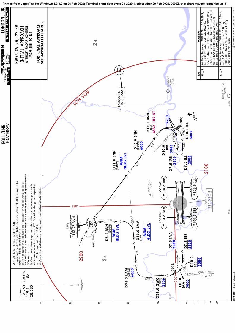
R358 GWCCWG114.75
132^
113.
6 LO
ND
L O
NLO
ND
ON
265^
BIG
GIN
HIL
LEGKB
LONDON
EGLC
NORTHOLT
EGW
U
City
51-30
00-00
00-30
23
24
180^
090^
2200
2100
LON V
OR
3000
2500
2500
3000
2500
3000
2500
3000
3500
6000
MNM
HLD
G L
VL
3500
6000
MNM
HLD
G L
VL
MNM
HLD
G L
VL
4.0
2.5
2.5
2.5
2.5
178^
270^
270^
090^
090^
D19.0
BNN
D10.0
ILL
D7.5
ILL
D7.5
IRR
D7.5
IA
A
D7.5
IBB
D30.0
LA
M
D34.0
LA
M
D39.0
GW
C
D10.0 IRR
D10.0
IAA
D10.0
IBB
(16N
M)
(13N
M)
(20N
M)
(24M
)
(12.
5NM
)
LOC D
ME
I B
B*10
9.5
IBB
LOC D
ME
I A
A*11
0.3
IAA
LOC D
ME
I L
L*10
9.5
ILL
LOC D
ME
I R
R*11
0.3
IRR
05101520 525
11
4.0
4.0
D11.0
BNN
D15.0
BNN
D5.0
BNN
(24N
M)
(20N
M)
(30N
M)
178^
127^
115.
6 LA
MD
L A
MLA
MBO
URN
E
113.
75 B
NN
D
B N
NBO
VIN
GD
ON
JEPPESEN
.INITIA
L.APPROACH.
WITHOUT
RADAR
CONTR
OL
RWYS 09
L/R, 2
7L/R
INITIA
L APP
ROACH
Apt
Ele
v*D
-ATI
S
113.
750
115.
112
8.08
083
Alt
Set
: hP
a T
rans
lev
el:
By
ATC
1. M
inim
um h
oldi
ng l
evel
(Fl
ight
Lev
el e
quiv
alen
t of
700
0) i
s ab
ove
TA
and
wil
l be
all
ocat
ed b
y A
TC.
2. I
niti
al a
ppro
ach
proc
edur
es a
re d
esig
ned
for
man
oeuv
ring
spe
eds
upto
220
KT
and
assu
me
acft
can
mai
ntai
n a
desc
ent
grad
ient
of
appr
oxim
atel
y32
0 pe
r N
M.
3. C
onti
nuou
s de
scen
t ap
proa
ch s
houl
d be
use
d w
hene
ver
prac
tica
ble
unle
ss o
ther
wis
e in
stru
cted
by
ATC
. Pr
oced
ure
desi
gn i
s co
mpa
tibl
e w
ith
3^ d
esce
nt p
ath
from
600
0.4.
App
roxi
mat
e di
stan
ces
to t
ouch
dow
n ar
e in
dica
ted
in b
rack
ets.
1087
(IA
F)
(35N
M)
5.0
297^
117^
MH
A 7
000
FROM B
NN T
O ILS
.Eff.23.May.
17 M
AY 1
9
MA
X 1
80 K
T
CHA
NG
ES:
RW
Y
09L/
R
27L/
R
RO
UTIN
G
EGLL/LHR
LONDON, UK
HEA
THRO
W10
-2Q
FO
R F
INA
L A
PPRO
ACH
SEE A
PPRO
ACH C
HA
RTS
At
BN
N,
inte
rcep
t BN
N R
178
to D
5.0
BN
N,
turn
RIG
HT,
int
erce
pt L
AM
R26
5 to
D
34.0
LA
M,
turn
LEF
T, i
nter
cept
GW
C R
358
inbo
und
to D
39.0
GW
C,
turn
LEF
T, e
stab
lish
on I
LS I
AA
by
D10
.0 I
AA
(RW
Y 0
9L)
or
on I
LS I
BB b
y D
10.0
IBB (
RWY 0
9R).
At
BN
N,
inte
rcep
t BN
N R
127
to D
19.0
BN
N,
turn
RIG
HT,
est
abli
sh o
n IL
S IL
L by
D
10.0
ILL
(RW
Y 2
7L)
or o
n IL
S IR
R by
D
10.0
IRR
(RW
Y 2
7R).
| J
EPPE
SEN
, 20
19.
ALL
RIG
HTS
RES
ERVED
.Cha
rt r
eind
exed
.
Printed from JeppView for Windows 5.3.0.0 on 06 Feb 2020; Terminal chart data cycle 03-2020; Notice: After 20 Feb 2020, 0000Z, this chart may no longer be valid

127^
R358 GWCCWG114.75
132^
113.
6 LO
ND
L O
NLO
ND
ON
BIG
GIN
HIL
LEGKBLONDON
EGLC
NORTHOLT
EGW
U
City
51-30
00-00
00-30
23
24
180^
090^
2200
2100
LON
VOR
3000
2500
2500
3000
2500
3000
2500
3000
3500
6000
6000
MNM
HLD
G L
VL
MNM
HLD
G L
VL
3500
1 1
30
4.0
2.5
2.5
2.5
2.5
178^
270^
270^
090^
090^
273 ^
265^
D15
.0 B
NN
D11.0
LA
M
D19.0
BNN
D10.0
ILL
D7.5
ILL
D7.5
IRR
D7.5
IA
A
D7.5
IBB
113.
75 B
NN
D
115.
6 LA
MD
L A
MLA
MBO
URN
E
B N
NBO
VIN
GD
ON
(Rw
ys 0
9L/R
55N
M)
(IA
F)
(Rw
ys 2
7L/R
35N
M)
D30.0
LA
M
D34.0
LA
M
D39.0
GW
C
D10.0 IRR
D10.0
IAA
D10.0
IBB
(25N
M)
(16N
M)
(13N
M)
(20N
M)
(24N
M)
(20N
M)
(12.
5NM
)
JEPPESEN
WITHOUT
RADAR
CONTR
OL
RWYS 09
L/R, 2
7L/R
INITIA
L APP
ROACH
Apt
Ele
v*D
-ATI
S
113.
750
115.
112
8.08
0
.INITIA
L.APPROACH.
83
Alt
Set
: hP
a T
rans
lev
el:
By
ATC
1. M
inim
um h
oldi
ng l
evel
(Fl
ight
Lev
el e
quiv
alen
t of
700
0) i
s ab
ove
TAan
d w
ill
be a
lloc
ated
by
ATC
.2.
Ini
tial
app
roac
h pr
oced
ures
are
des
igne
d fo
r m
anoe
uvri
ng s
peed
s up
to 2
20 K
T an
d as
sum
e ac
ft c
an m
aint
ain
a de
scen
t gr
adie
nt o
f ap
prox
imat
ely
320
per
NM
.3.
Con
tinu
ous
desc
ent
appr
oach
sho
uld
be u
sed
whe
neve
r pr
acti
cabl
eun
less
oth
erw
ise
inst
ruct
ed b
y A
TC.
Proc
edur
e de
sign
is
com
pati
ble
wit
h 3^
des
cent
pat
h fr
om 6
000.
4. A
ppro
xim
ate
dist
ance
s to
tou
chdo
wn
are
indi
cate
d in
bra
cket
s.
LOC D
ME
I B
B*10
9.5
IBB
LOC D
ME
I A
A*11
0.3
IAA
LOC D
ME
I L
L*10
9.5
ILL
LOC D
ME
I R
R*11
0.3
IRR
083^
263^
MH
A 7
000
05101520 525
1087
FROM LAM T
O ILS
.Eff.23.May.
17 M
AY 1
9
MA
X 1
80 K
T
CHA
NG
ES:
EGLL/LHR
RW
Y
09L/
R
27L/
R
RO
UTIN
G
At
LAM
, in
terc
ept
LAM
R26
5 to
D34
.0 L
AM
,tu
rn L
EFT,
int
erce
pt G
WC R
358
inbo
und
toD
39.0
GW
C,
turn
LEF
T, e
stab
lish
on
ILS
IAA
by
D10
.0 I
AA
(RW
Y 0
9L)
or o
nIL
S IB
B b
y D
10.0
IBB (
RWY 0
9R).
At
LAM
, in
terc
ept
LAM
R27
3 to
D11
.0 L
AM
,tu
rn L
EFT,
int
erce
pt B
NN
R12
7 to
D19
.0 B
NN
, tu
rn R
IGH
T, e
stab
lish
on
ILS
ILL
by D
10.0
ILL
(RW
Y 2
7L)
or o
nIL
S IR
R by
D10
.0 I
RR (
RWY 2
7R).
LONDON, UK
10-2
SHEA
THRO
W
FO
R F
INA
L A
PPRO
ACH
SEE A
PPRO
ACH C
HA
RTS
Cha
rt r
eind
exed
.|
JEP
PESE
N,
2019
. A
LL R
IGHTS
RES
ERVED
.
Printed from JeppView for Windows 5.3.0.0 on 06 Feb 2020; Terminal chart data cycle 03-2020; Notice: After 20 Feb 2020, 0000Z, this chart may no longer be valid

063^
358^ GWCCWG114.75
113.
6 LO
ND
L O
NLO
ND
ON
BIG
GIN
HIL
LEGKB
LONDON
Gatw
ick
EGKK
LONDON
EGLC
FARNBOROUGH
EGLF
ODIH
AM
EGVO
NORTHOLT
EGW
U
City
51-30 01-00
00-00
00-30
24
23
24
180^
090^
2200
2100
LON VOR
3000
3000
2500
2500
6000
2500
3000
2500
3000
3500
6000
MNM
HLD
G L
VL
3500
MNM
HLD
G L
VL
4.0
1.0
2.5
2.5
2.5
2.5
287^
074^
359^27
0^
270^
090^
090^
Apt
Ele
vWITHOUT
RADAR
CONTR
OL
RWYS 09
L/R, 2
7L/R
*D
-ATI
SINITIA
L APP
ROACH
113.
750
115.
112
8.08
0
D8.0
OCK
D12.0
OCK
D35.0
GW
C
D7.0
OCK
D11.0
OCK
D12.0
OCK
D10.0
IRR
D7.5
IRR
D7.5
ILL
D10.0
IA
A
D7.5
IBB
D7.5
IA
A
(23N
M)
(19N
M)
(18N
M)
(13.
5NM
)
(13N
M)
(18N
M) (2
2NM
)
LOC D
ME
LOC D
ME
I B
BI
L L
*10
9.5
IBB
*10
9.5
ILL
149^ 32
9^M
HA
700
0
115.
3 O
CK
D O C
KO
CKH
AM
(IA
F)
LOC D
ME
I R
R*11
0.3
IRR
LOC D
ME
I A
A*11
0.3
IAA
D10.0
ILL
D10.0
IBB
JEPPESEN
Alt
Set
: hP
a T
rans
lev
el:
By
ATC
1. M
inim
um h
oldi
ng l
evel
(Fl
ight
Lev
el e
quiv
alen
t of
700
0) i
s ab
ove
TAan
d w
ill
be a
lloc
ated
by
ATC
.2.
Ini
tial
app
roac
h pr
oced
ures
are
des
igne
d fo
r m
anoe
uvri
ng s
peed
s up
to 2
20 K
T an
d as
sum
e ac
ft c
an m
aint
ain
a de
scen
t gr
adie
nt o
f ap
prox
imat
ely
320
per
NM
.3.
Con
tinu
ous
desc
ent
appr
oach
sho
uld
be u
sed
whe
neve
r pr
acti
cabl
eun
less
oth
erw
ise
inst
ruct
ed b
y A
TC.
Proc
edur
e de
sign
is
com
pati
ble
wit
h 3^
des
cent
pat
h fr
om 6
000.
4. A
ppro
xim
ate
dist
ance
s to
tou
chdo
wn
are
indi
cate
d in
bra
cket
s.
8305101520 525
1305
4.0
8.0
(30N
M)
7.0
FROM O
CK T
O ILS
.INITIA
L.APPROACH.
.Eff.23.May.
17 M
AY 1
9
CHA
NG
ES:
FO
R F
INA
L A
PPRO
ACH
SEE A
PPRO
ACH C
HA
RTS
RO
UTIN
GRW
Y
09L/
R
27L/
R
At
OCK,
inte
rcep
t O
CK R
287
to D
12.0
OCK,
turn
RIG
HT,
int
erce
pt G
WC R
358
to
D35
.0 G
WC,
turn
RIG
HT,
est
abli
sh o
n IL
S IA
A b
y D
10.0
IA
A (
RWY 0
9L)
or o
n IL
S IB
B b
y D
10.0
IBB (
RWY 0
9R).
At
OCK,
inte
rcep
t O
CK R
074
to D
12.0
OCK,
turn
LEF
T, 3
59^
trac
k, w
hen
cros
sing
O
CK R
-063
tur
n LE
FT,
esta
blis
h on
ILS
ILL
by
D10
.0 I
LL (
RWY 2
7L)
or o
n IL
S IR
R by
D
10.0
IRR
(RW
Y 2
7R).
10-2
TEG
LL/LHR
HEA
THRO
WLO
NDON, UK
Cha
rt r
eind
exed
.|
JEP
PESE
N,
2019
. A
LL R
IGHTS
RES
ERVED
.
Printed from JeppView for Windows 5.3.0.0 on 06 Feb 2020; Terminal chart data cycle 03-2020; Notice: After 20 Feb 2020, 0000Z, this chart may no longer be valid

326^
305^
NORTHOLTEGWU
COMMS LOST COMMS LOST COMMS LOST
LOST
COMMS COMMS LOST COMMS LOST
LOST
51-30
00-30
23
180^
090^
2200
2100MSA LON VOR
60004000
60005000
6000
6000
D6 LON
064^
D3 LON
298^
10-3 .SID.
JEPPESENEGLL/LHRHEATHROW
LONDON, UK
Trans alt: 60000
510
1520
525
117.5 BPKD
BROOKMANSPARK
B P K
277 CHTCHILTERN
C H T
421 BURBURNHAM
B U R
113.6 LONDLONDON
L O N
BPK 7G
BPK 7F1
2
D4LON
054^
3
17
R244
6000
590.
1087
[D326G]
30 NOV 18
Comply with route andaltitude restrictions of SID.
| JEPPESEN, 2017, 2018. ALL RIGHTS RESERVED.
.Eff.6.Dec.
LONDON Control
118.825Apt Elev
83
Radial update.
MAX 250 KT BELOW FL100 UNLESS OTHERWISE AUTHORISED.SPEED:
27RBPK 7F
BPK 7G 27L
4% V/V (fpm)
75 100
405304
150
608 810 1013 1215
300250200Gnd speed-KT1090,
RWYSID
Cross appropriate Noise Monitoring Terminal(refer to chart 10-4) at or above
ROUTING / ALTITUDE
RWYS 27R/L DEPARTURES
If unable to comply with SID or climb gradientinform ATC prior to take-off.for ATM purposes.
thereafter maintain a minimum climb gradientof4% up to
Climb straight ahead, intercept 298^ bearing towards BUR by D4 LON, atD6 LON turn RIGHT, intercept 054^ bearing towards CHT, cross LON R305
Climb straight ahead, intercept 298^ bearing towards BUR by D3 LON, atD6 LON turn RIGHT, intercept 054^ bearing towards CHT, cross LON R305
CHANGES:
4000
at or above 4000 (MAX 6000), LON R326 at or above 5000 (MAX 6000),to CHT at 6000, turn RIGHT, intercept BPK R244 inbound to BPK.
at or above 4000 (MAX 6000), LON R326 at or above 5000 (MAX 6000),to CHT at 6000 turn RIGHT, intercept BPK R244 inbound to BPK.
WARNING: Due to interaction withother routes do not climb above
until cleared by ATC.
AVERAGE TRACK MILEAGE32 NM to BPK.
WARNINGNo turns below
BPK 7FBPK 7G
1. When instructed contact LONDON Control after take-off, report C/S,SID designator, current altitude and initial cleared altitude.2. SIDs include noise preferential routes (refer to 10-4).3. Cruising levels will be issued after take-off by LONDON Control.4. Do not climb above SID levels until instructed by ATC.
Printed from JeppView for Windows 5.3.0.0 on 06 Feb 2020; Terminal chart data cycle 03-2020; Notice: After 20 Feb 2020, 0000Z, this chart may no longer be valid
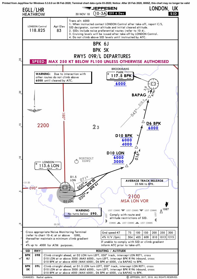
071^
D18.
9
043^
D
NORTHOLTEGWU
COMMS LOST COMMS LOST COMMS LOST
LOST
COMMS COMMS LOST COMMS LOST
LOST
51-30
00-30
23180^
090^
2200
2100MSA LON VOR
60003000
60004000
6000
6000
.SID.
JEPPESENEGLL/LHRHEATHROW 10-3A
LONDON, UK
Trans alt: 60000
510
1520
525
D6 BPK
BAPAG R196
117.5 BPKD
BROOKMANSPARK
B P K
113.6 LOND
LONDON
L O N
050^
050^
BPK
6JBPK
5K
D1.5LON
D2 LON
D10 LON
D10 BPK
2.0
6000
590.
1087
30 NOV 18
Comply with route andaltitude restrictions of SID.
| JEPPESEN, 2017, 2018. ALL RIGHTS RESERVED.
.Eff.6.Dec.
LONDON Control
118.825Apt Elev
83
4
4
016^
Radial update.
MAX 250 KT BELOW FL100 UNLESS OTHERWISE AUTHORISED.SPEED:
09R
4% V/V (fpm)
75 100
405304
150
608 810 1013 1215
300250200Gnd speed-KT1090,
RWYSID
RWYS 09R/L DEPARTURES
Cross appropriate Noise Monitoring Terminal(refer to chart 10-4) at or above
ROUTING / ALTITUDE
If unable to comply with SID or climb gradientinform ATC prior to take-off.
BPK6J
09LBPK5K
for ATM purposes.
thereafter maintain a minimum climb gradientof4% up to
CHANGES:
4000
WARNING: Due to interaction withother routes do not climb above
until cleared by ATC.
WARNINGNo turns below
AVERAGE TRACK MILEAGE23 NM to BPK.
Climb straight ahead, at D2 LON turn LEFT, 050^ track, intercept LON R071, crossD10 LON at or above 3000 (MAX 6000), turn LEFT, intercept BPK R196 inbound, crossD10 BPK at or above 4000 (MAX 6000), D6 BPK at 6000, via BAPAG to BPK.
Climb straight ahead, at D1.5 LON turn LEFT, 050^ track, intercept LON R071, crossD10 LON at or above 3000 (MAX 6000), turn LEFT, intercept BPK R196 inbound, crossD10 BPK at or above 4000 (MAX 6000), D6 BPK at 6000, via BAPAG to BPK.
BPK 5KBPK 6J
1. When instructed contact LONDON Control after take-off, report C/S,SID designator, current altitude and initial cleared altitude.2. SIDs include noise preferential routes (refer to 10-4).3. Cruising levels will be issued after take-off by LONDON Control.4. Do not climb above SID levels until instructed by ATC.
Printed from JeppView for Windows 5.3.0.0 on 06 Feb 2020; Terminal chart data cycle 03-2020; Notice: After 20 Feb 2020, 0000Z, this chart may no longer be valid

256^
FARNBOROUGH
EGLF
NORTHOLT
EGW
U
COMMS
LOST
COMMS
LOST
COMMS
LOST
LOST
COMMS
COMMS
LOST
COMMS
LOST
LOST
180^
090^
2100
2200
LON VOR
6000
3000
6000
4000
6000
6000
.SID.
JEPPESEN
05
1015
205
25
EGLL/LHRHEATHROW 10-3B
LONDON, UK
Tran
s al
t: 6
000
D7 L
ON
269^
D8 C
PT
281^ W
OO
DLE
Y35
2 W
OD
W O
D
113.
6 LO
ND
LON
DO
N
L O
N
114.3
5 C
PT
DCO
MPT
ON
C P
TCPT 3
GCPT 3
F
D11 L
ON
D17 C
PT
55
D13 C
PT
8R1
01
6000
590.
1225
30 NOV 18
Com
ply
wit
h ro
ute
and
alti
tude
res
tric
tion
s of
SID
.
.Eff.6.Dec.
LON
DO
N C
ontr
ol
134.
125
Apt
Ele
v
83
| JEPPESEN, 2018. ALL RIGHTS RESERVED.Radial update.
24
23
51-30
01-00
00-30
MA
X 2
50 K
T B
ELO
W F
L100 U
NLE
SS O
THERW
ISE A
UTHO
RIS
ED
.SPEED
:
27R
CPT 3
F
CPT 3
G27L
4000
.
4% V
/V (
fpm
)
7510
0
405
304
150
608
810
1013
1215
300
250
200
Gnd
spe
ed-K
T
1090
,
RW
YSID
506
380
760
1013
1266
1519
5% V
/V (
fpm
)
RWYS 27
R/L DEP
ART
URE
S
Cro
ss a
ppro
pria
te N
oise
Mon
itor
ing
Term
inal
(ref
er t
o ch
art
10-4
) at
or
abov
e
RO
UTIN
G /
ALT
ITUDE
If u
nabl
e to
com
ply
wit
h SI
D o
r cl
imb
grad
ient
info
rm A
TC p
rior
to
take
-off
.
ther
eaft
er m
aint
ain
a m
inim
um c
lim
b gr
adie
ntof 4%
up
toTh
ese
SID
s re
quir
e a
min
imum
cli
mb
grad
ient
of 5% u
ntil
D8
CPT
due
to
ATC
CHANGES:
and
airs
pace
pur
pose
s.
Stra
ight
ahe
ad,
inte
rcep
t LO
N R
256
to D
7 LO
N,
turn
RIG
HT,
inte
rcep
t 26
9^ b
eari
ng t
owar
ds W
OD
(D
13 C
PT),
cro
ss D
11 L
ON
(D17
CPT
) ab
ove
3000
(M
AX 6
000)
, cr
oss
WO
D (
D13
CPT
)ab
ove
4000
(M
AX 6
000)
, th
en t
o CPT
, cr
oss
D8
CPT
at
6000
.
WA
RNIN
G:
Due
to
inte
ract
ion
wit
hot
her
rout
es d
o no
t cl
imb
abov
eun
til
clea
red
by A
TC.
WA
RNIN
GN
o tu
rns
belo
w
AVERA
GE T
RA
CK M
ILEA
GE
15 N
M t
o W
OD
.
CPT
3F, C
PT 3
G
1. W
hen
inst
ruct
ed c
onta
ct L
ON
DO
N C
ontr
ol a
fter
tak
e-of
f, r
epor
tC/S
, SI
D d
esig
nato
r, c
urre
nt a
ltit
ude
and
init
ial
clea
red
alti
tude
.2.
SID
s in
clud
e no
ise
pref
eren
tial
rou
tes
(ref
er t
o 10
-4).
3. C
ruis
ing
leve
ls w
ill
be i
ssue
d af
ter
take
-off
by
LON
DO
N C
ontr
ol.
4. D
o no
t cl
imb
abov
e SI
D l
evel
s un
til
inst
ruct
ed b
y A
TC.
5. E
XPE
CT
firs
t CPD
LC D
ata
Link
Aut
hori
ty t
o be
EG
TT.
Printed from JeppView for Windows 5.3.0.0 on 06 Feb 2020; Terminal chart data cycle 03-2020; Notice: After 20 Feb 2020, 0000Z, this chart may no longer be valid
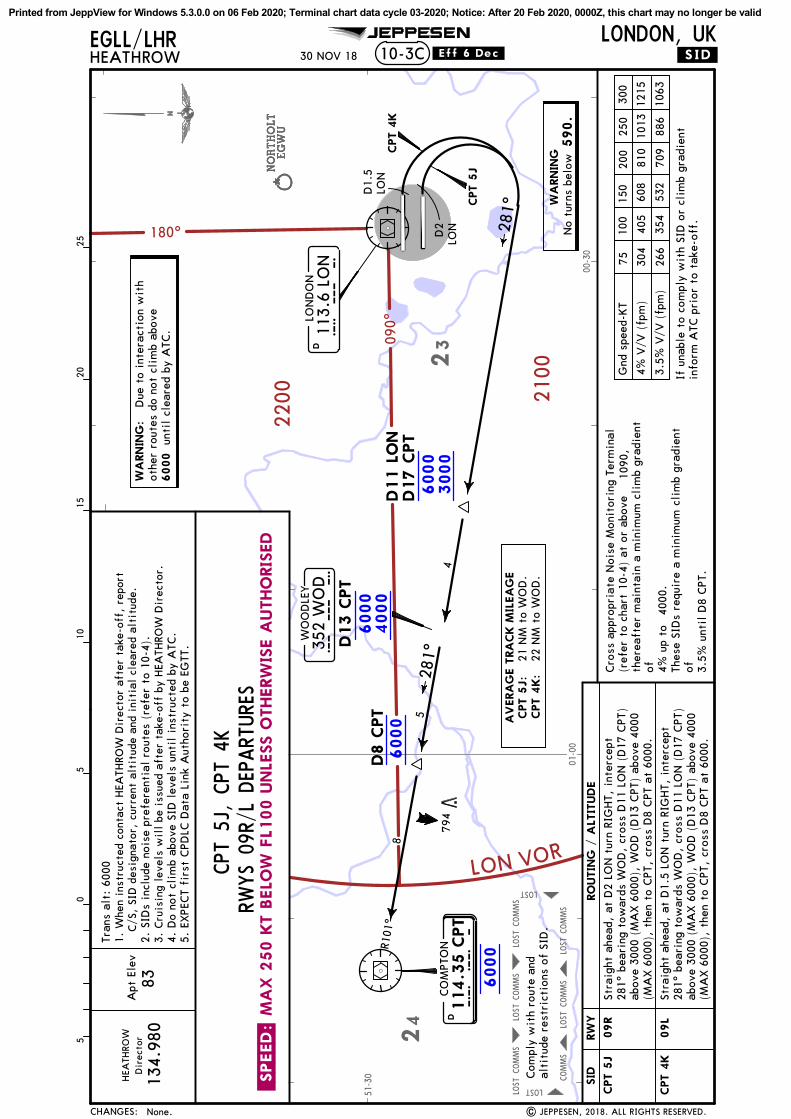
NORTHOLT
EGW
UNORTHOLT
EGW
UNORTHOLT
EGW
U
COMMS
LOST
COMMS
LOST
COMMS
LOST
LOST
COMMS
COMMS
LOST
COMMS
LOST
LOST
51-30
01-00
00-30
24
23
180^
090^
2100
2200
LON VOR
6000
3000
6000
4000
6000
6000
Apt
Ele
vD
irec
tor
134.
980
281^
D8 C
PT
.SID.
JEPPESENEGLL/LHRHEATHROW 10-3C
LONDON, UK
05
1015
205
25
83
Tran
s al
t: 6
000
113.
6 LO
ND
LON
DO
N
L O
N
114.3
5 C
PT
DCO
MPT
ON
C P
T
WO
OD
LEY
352
WO
DW
O D
D1.
5LO
N
D2
LON
CPT 4
K
CPT 5
J
D11 L
ON
D17 C
PT
4
5
8
281^
D13 C
PT
6000
590.
R101
^
794
30 NOV 18
Com
ply
wit
h ro
ute
and
alti
tude
res
tric
tion
s of
SID
.
.Eff.6.Dec.
| JEPPESEN, 2018. ALL RIGHTS RESERVED.
HEA
THRO
W
None.
.SPEED
:M
AX 2
50 K
T B
ELO
W F
L100 U
NLE
SS O
THERW
ISE A
UTHO
RIS
ED
09R
CPT 5
J
CPT 4
K09L
4000
.
4% V
/V (
fpm
)
7510
0
405
304
150
608
810
1013
1215
300
250
200
Gnd
spe
ed-K
T10
90,
RW
YSID
354
266
532
709
886
1063
RWYS
09R/
L DEP
ART
URE
S
Cro
ss a
ppro
pria
te N
oise
Mon
itor
ing
Term
inal
(ref
er t
o ch
art
10-4
) at
or
abov
e
RO
UTIN
G /
ALT
ITUDE
If u
nabl
e to
com
ply
wit
h SI
D o
r cl
imb
grad
ient
info
rm A
TC p
rior
to
take
-off
.
ther
eaft
er m
aint
ain
a m
inim
um c
lim
b gr
adie
ntof 4%
up
toTh
ese
SID
s re
quir
e a
min
imum
cli
mb
grad
ient
of 3.5%
unt
il D
8 CPT
.
3.5%
V/V
(fp
m)
281^
bea
ring
tow
ards
WO
D,
cros
s D
11 L
ON
(D
17 C
PT)
281^
bea
ring
tow
ards
WO
D,
cros
s D
11 L
ON
(D
17 C
PT)
CHANGES:
Stra
ight
ahe
ad,
at D
2 LO
N t
urn
RIG
HT,
int
erce
pt
Stra
ight
ahe
ad,
at D
1.5
LON
tur
n RI
GH
T, i
nter
cept
abov
e 30
00 (
MA
X 6
000)
, W
OD
(D
13 C
PT)
abov
e 40
00(M
AX 6
000)
, th
en t
o CPT
, cr
oss
D8
CPT
at
6000
.
abov
e 30
00 (
MA
X 6
000)
, W
OD
(D
13 C
PT)
abov
e 40
00(M
AX 6
000)
, th
en t
o CPT
, cr
oss
D8
CPT
at
6000
.
AV
ERA
GE T
RA
CK M
ILEA
GE
CPT 5
J:
21 N
M t
o W
OD
.CPT 4
K:
22 N
M t
o W
OD
.
WA
RNIN
G:
Due
to
inte
ract
ion
wit
hot
her
rout
es d
o no
t cl
imb
abov
eun
til
clea
red
by A
TC.
WA
RNIN
GN
o tu
rns
belo
w
CPT
5J, C
PT 4
K
1. W
hen
inst
ruct
ed c
onta
ct H
EATH
ROW
Dir
ecto
r af
ter
take
-off
, re
port
C
/S,
SID
des
igna
tor,
cur
rent
alt
itud
e an
d in
itia
l cl
eare
d al
titu
de.
2. S
IDs
incl
ude
nois
e pr
efer
enti
al r
oute
s (r
efer
to
10-4
).3.
Cru
isin
g le
vels
wil
l be
iss
ued
afte
r ta
ke-o
ff b
y HEA
THRO
W D
irec
tor.
4. D
o no
t cl
imb
abov
e SI
D l
evel
s un
til
inst
ruct
ed b
y A
TC.
5. E
XPE
CT
firs
t CPD
LC D
ata
Link
Aut
hori
ty t
o be
EG
TT.
Printed from JeppView for Windows 5.3.0.0 on 06 Feb 2020; Terminal chart data cycle 03-2020; Notice: After 20 Feb 2020, 0000Z, this chart may no longer be valid

BIG
GIN
HIL
LEGKB
NORTHOLT
EGW
U
COMMS
LOST
COMMS
LOST
COMMS
LOST
LOST
COMMS
COMMS
LOST
COMMS
LOST
LOST
51-30
00-00
00-30
23
24
180^
090^
2200
2100
MSA
LO
N V
OR
6000
4000
6000
5000
6000
6000
6000
Apt
Ele
vLO
ND
ON
Con
trol
120.
530
091^
EPSO
M31
6 EP
ME P
M
.SID.
JEPPESEN
05
1015
205
25
EGLL/LHRHEATHROW 10-3D
LONDON, UK
83
Tran
s al
t: 6
000
D2
LON
D1
ILL
DET
LIN
G
D E
T117.3
DET
D
LOC D
ME
I L
L
113.
6 LO
ND
LON
DO
N
L O
NDET 2
F
DET 2
G
137^
1
53
245
D10 L
ON
D32 D
ET
D29 D
ET
D5 D
ET
R 27 1
NO
T T
O S
CA
LE
590.
6000
1087
* 1
09.5
ILL
22 FEB 19
Com
ply
wit
h ro
ute
and
alti
tude
res
tric
tion
s of
SID
.
.Eff.28.Feb.
Communication. | JEPPESEN, 2018, 2019. ALL RIGHTS RESERVED.
MA
X 2
50 K
T B
ELO
W F
L100 U
NLE
SS O
THERW
ISE A
UTHO
RIS
ED
.SPEED
:
5% V
/V (
fpm
)
7510
0
506
380
150
760
1013
1266
1519
300
250
200
Gnd
spe
ed-K
T
466
349
699
932
1165
1398
Thes
e SI
Ds
requ
ire
min
imum
cli
mb
grad
ient
sof
405
304
608
810
1013
1215
4% V
/V (
fpm
)
RWYS
27R/
L DEP
ART
URE
S
27R
27L
RW
YSID
DET 2
F
DET 2
G
RO
UTIN
G /
ALT
ITUDE
If u
nabl
e to
com
ply
wit
h SI
D o
r cl
imb
grad
ient
info
rm A
TC p
rior
to
take
-off
.
4.6%
V/V
(fp
m)
4.6%
unt
il E
PM.
5% u
ntil
EPM
due
to
ATC
and
air
spac
e pu
rpos
es.
DET 2
F
DET 2
G
1. W
hen
inst
ruct
ed c
onta
ct L
ON
DO
N C
ontr
ol a
fter
tak
e-of
f, r
epor
t C
/S,
SID
des
igna
tor,
cur
rent
alt
itud
e an
d in
itia
l cl
eare
d al
titu
de.
2. S
IDs
incl
ude
nois
e pr
efer
enti
al r
oute
s (r
efer
to
10-4
).3.
Cru
isin
g le
vels
wil
l be
iss
ued
afte
r ta
ke-o
ff b
y LO
ND
ON
Con
trol
.4.
Do
not
clim
b ab
ove
SID
lev
els
unti
l in
stru
cted
by
ATC
.
CHANGES:
Stra
ight
ahe
ad,
at D
2 LO
N t
urn
LEFT
, in
terc
ept
137^
bea
ring
to
EPM
, cr
oss
at o
r ab
ove
4000
(MA
X 6
000)
at
EPM
but
not
bef
ore
D10
LO
N i
nter
cept
DET
R27
1 in
boun
d, c
ross
D32
DET
at
or
abov
e 50
00 (
MA
X 6
000)
, D
29 D
ET a
t 60
00,
D5
DET
at
6000
, th
en t
o D
ET.
Stra
ight
ahe
ad,
at D
1 IL
L (D
2 LO
N i
f IL
L u/
s) t
urn
LEFT
, in
terc
ept
137^
bea
ring
to
EPM
,cr
oss
at o
r ab
ove
4000
(M
AX 6
000)
, at
EPM
but
not
bef
ore
D10
LO
N i
nter
cept
DET
R27
1 in
boun
d,
cros
s D
32 D
ET a
t or
abo
ve 5
000
(MA
X 6
000)
, D
29 D
ET a
t 60
00,
D5
DET
at
6000
, th
en t
o D
ET.
Cro
ss a
ppro
pria
te N
oise
Mon
itor
ing
Term
inal
(ref
er t
o ch
art
10-4
) at
or
abov
e 10
90,
ther
eaft
er m
aint
ain
a m
inim
um c
lim
b gr
adie
ntof 4%
up
to 4
000.
AVERA
GE T
RA
CK M
ILEA
GE
50 N
M t
o D
ET.
DET 2
F:
49 N
M t
o D
ET.
DET 2
G:
WA
RNIN
GN
o tu
rns
belo
w
WA
RNIN
G:
Due
to
inte
ract
ion
wit
hot
her
rout
es d
o no
t cl
imb
abov
eun
til
clea
red
by A
TC.
DET
2F
DET
2G
Printed from JeppView for Windows 5.3.0.0 on 06 Feb 2020; Terminal chart data cycle 03-2020; Notice: After 20 Feb 2020, 0000Z, this chart may no longer be valid

BIG
GIN
HIL
LEGKB
NORTHOLT
EGW
U
COMMS
LOST
COMMS
LOST
COMMS
LOST
LOSTCOMMS
COMMS
LOST
COMMS
LOST
LOST
51-30
00-00
00-30
23
24
180^
090^22
00
2100
LON VOR
6000
3000
6000
5000
6000
6000
6000
Apt
Ele
vLO
ND
ON
Con
trol
120.
530
22 FEB 19 .SID.
JEPPESEN
05
1015
205
25
EGLL/LHRHEATHROW 10-3E
LONDON, UK
83
Tran
s al
t: 6
000
113.
6 LO
ND
LON
DO
N
L O
N
117.3
DET
DD
ETLI
NG
D E
T
D1.
5 LO
N
D2
LON
D4
LON
DET
1K
DET
1J122^
121^
103^
D34 D
ET 5
9
4
11
5
D29 D
ET
D20 D
ET
D16 D
ET
D5 D
ET
NO
T T
O S
CA
LE
R283
6000
590.
1087
Com
ply
wit
h ro
ute
and
alti
tude
res
tric
tion
s of
SID
.
.Eff.28.Feb.
Communication. | JEPPESEN, 2018, 2019. ALL RIGHTS RESERVED.
MA
X 2
50 K
T B
ELO
W F
L100 U
NLE
SS O
THERW
ISE A
UTHO
RIS
ED
.SPEED
:
09R
09L
RW
YSID
RWYS 09
R/L DEP
ART
URE
S
DET 1
J
DET 1
K
1090
,
4% V
/V (
fpm
)
7510
0
405
304
150
608
810
1013
1215
300
250
200
Gnd
spe
ed-K
T
Cro
ss a
ppro
pria
te N
oise
Mon
itor
ing
Term
inal
(ref
er t
o ch
art
10-4
) at
or
abov
e
RO
UTIN
G /
ALT
ITUDE
If u
nabl
e to
com
ply
wit
h SI
D o
r cl
imb
grad
ient
info
rm A
TC p
rior
to
depa
rtur
e.
1. W
hen
inst
ruct
ed c
onta
ct L
ON
DO
N C
ontr
ol a
fter
tak
e-of
f, r
epor
t C
/S,
SID
des
igna
tor,
cur
rent
alt
itud
e an
d in
itia
l cl
eare
d al
titu
de.
2. S
IDs
incl
ude
nois
e pr
efer
enti
al r
oute
s (r
efer
to
10-4
).3.
Cru
isin
g le
vels
wil
l be
iss
ued
afte
r ta
ke-o
ff b
y LO
ND
ON
Con
trol
.4.
Do
not
clim
b ab
ove
SID
lev
els
unti
l in
stru
cted
by
ATC
.
CHANGES:
ther
eaft
er m
aint
ain
a m
inim
um c
lim
b gr
adie
ntof 4%
up
to 4
000.
Stra
ight
ahe
ad,
at D
2 LO
N t
urn
RIG
HT,
121
^ tr
ack,
at
D4
LON
tur
n LE
FT,
inte
rcep
t D
ET R
283
inbo
und
by D
34 D
ET,
cros
s D
29 D
ET a
t or
abo
ve 3
000
(MA
X 6
000)
, D
20 D
ET a
t or
abo
ve 5
000
(MA
X 6
000)
, D
16 D
ET a
t 60
00,
D5
DET
at
6000
, th
en t
o D
ET.
Stra
ight
ahe
ad,
at D
1.5
LON
tur
n RI
GHT,
122
^ tr
ack,
at
D4
LON
tur
n LE
FT,
inte
rcep
t D
ET R
283
inbo
und
by D
34 D
ET,
cros
s D
29 D
ET a
t or
abo
ve 3
000
(MA
X 6
000)
, D
20 D
ET a
t or
abo
ve 5
000
(MA
X 6
000)
, D
16 D
ET a
t 60
00,
D5
DET
at
6000
, th
en t
o D
ET.
AVERA
GE T
RA
CK M
ILEA
GE
41 N
M t
o D
ET.
WA
RNIN
G:
Due
to
inte
ract
ion
wit
hot
her
rout
es d
o no
t cl
imb
abov
eun
til
clea
red
by A
TC.
WA
RNIN
GN
o tu
rns
belo
w
DET
1K
DET
1J
Printed from JeppView for Windows 5.3.0.0 on 06 Feb 2020; Terminal chart data cycle 03-2020; Notice: After 20 Feb 2020, 0000Z, this chart may no longer be valid

253^
125^
R042
D20
.2
SAMMAS
D21.
0
113.35
045^
FARNBOROUGH
EGLF
ODIH
AM
EGVO
COMMS
LOST
COMMS
LOST
COMMS
LOST
LOSTCOMMS
COMMS
LOST
COMMS
LOST
LOST
51-30
01-00
00-30
24
23
180^
090^
2100
2200
LON
VOR
6000
3000
6000
4000
6000
5000
6000
6000
Apt
Ele
vLO
ND
ON
Con
trol
134.
125
D5 L
ON
D2 O
CK
D3 O
CK
GA
SG
U9.
2
.SID.
JEPPESENEGLL/LHRHEATHROW
LONDON, UK10-3F
05
1015
205
25
83
Tran
s al
t: 6
000
113.
6 LO
ND
LON
DO
N
L O
N
115.
3 O
CK
DO
CKHA
M
O C
K
GA
SG
U 1
K
GA
SG
U 1
J
D1.
5 LO
N
D2
LON
222^
4
4
D7 O
CK
D11 O
CK6000
590.
1225
Com
ply
wit
h ro
ute
and
alti
tude
res
tric
tion
s of
SID
.
| JEPPESEN, 2018. ALL RIGHTS RESERVED.Radial update.
30 NOV 18 .Eff.6.Dec.
MA
X 2
50 K
T B
ELO
W F
L100 U
NLE
SS O
THERW
ISE A
UTHO
RIS
ED
.SPEED:
RWYS 09
R/L DEP
ART
URE
S
09R
09L
RW
YSID
RO
UTIN
G /
ALT
ITUDE
GA
SG
U 1
J
GA
SG
U 1
K
CHANGES:
GASG
U 1
J [GASG
1J]
Stra
ight
ahe
ad,
at D
2 LO
N t
urn
RIG
HT,
int
erce
pt L
ON
R12
5 to
D5
LON
, tu
rnRI
GHT,
int
erce
pt O
CK R
042
inbo
und,
cro
ss D
2 O
CK a
bove
300
0 (M
AX 6
000)
, tu
rnRI
GHT,
int
erce
pt O
CK R
253,
cro
ss D
3 O
CK a
bove
400
0 (M
AX 6
000)
, D
7 O
CK
abov
e 50
00 (
MA
X 6
000)
, D
11 O
CK a
t 60
00 t
o G
ASG
U.
Stra
ight
ahe
ad,
at D
1.5
LON
tur
n RI
GH
T, i
nter
cept
LO
N R
125
to D
5 LO
N,
turn
RIG
HT,
int
erce
pt O
CK R
042
inbo
und,
cro
ss D
2 O
CK a
bove
300
0 (M
AX 6
000)
, tu
rnRI
GHT,
int
erce
pt O
CK R
253,
cro
ss D
3 O
CK a
bove
400
0 (M
AX 6
000)
, D
7 O
CK
abov
e 50
00 (
MA
X 6
000)
, D
11 O
CK a
t 60
00 t
o G
ASG
U.
WA
RNIN
G:
Due
to
inte
ract
ion
wit
hot
her
rout
es d
o no
t cl
imb
abov
eun
til
clea
red
by A
TC.
WA
RNIN
GN
o tu
rns
belo
w
AVERA
GE T
RA
CK M
ILEA
GE
33 N
M t
o G
ASG
U.
4% V
/V (
fpm
)
7510
0
405
304
150
608
810
1013
1215
300
250
200
Gnd
spe
ed-K
T
4000
.
1090
,Cro
ss a
ppro
pria
te N
oise
Mon
itor
ing
Term
inal
(ref
er t
o ch
art
10-4
) at
or
abov
e
If u
nabl
e to
com
ply
wit
h SI
D o
r cl
imb
grad
ient
info
rm A
TC p
rior
to
depa
rtur
e.
ther
eaft
er m
aint
ain
a m
inim
um c
lim
b gr
adie
ntof 4%
up
to
, GASG
U 1
K [GASG
1K]
1. W
hen
inst
ruct
ed c
onta
ct L
ON
DO
N C
ontr
ol a
fter
tak
e-of
f, r
epor
t
C/S
, SI
D d
esig
nato
r, c
urre
nt a
ltit
ude
and
init
ial
clea
red
alti
tude
.2.
SID
s in
clud
e no
ise
pref
eren
tial
rou
tes
(ref
er t
o 10
-4).
3. C
ruis
ing
leve
ls w
ill
be i
ssue
d af
ter
take
-off
by
LON
DO
N C
ontr
ol.
4. D
o no
t cl
imb
abov
e SI
D l
evel
s un
til
inst
ruct
ed b
y A
TC.
5. E
XPE
CT
firs
t CPD
LC D
ata
Link
Aut
hori
ty t
o be
EG
TT.
Printed from JeppView for Windows 5.3.0.0 on 06 Feb 2020; Terminal chart data cycle 03-2020; Notice: After 20 Feb 2020, 0000Z, this chart may no longer be valid
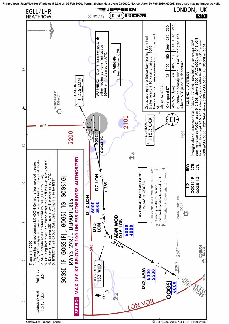
SAMMAS
D24.0
113.3
5
256^
R034
D20
.926
8^FARNBOROUGH
EGLF
ODIH
AM
EGVO
NORTHOLT
EGW
U
ODIH
AM
EGVO
NORTHOLT
EGW
U
COMMS
LOST
COMMS
LOST
COMMS
LOST
LOST
COMMS
COMMS
LOST
COMMS
LOST
LOST
01-00
00-30
24
23
180^
090^
2200
2100
LON VOR
6000
3000
6000
4000
6000
5500
6000
LON
DO
N C
ontr
olA
pt E
lev
134.
125
GO
GSI
.SID.
JEPPESENEGLL/LHRHEATHROW 10-3G
LONDON, UK
05
1015
205
25
83
Tran
s al
t: 6
000
113.
6 LO
ND
LON
DO
N
L O
N
GO
GSI 1F
GO
GSI 1G
D7 L
ON
269^
D12 L
ON
1
D13
LON
WO
OD
LEY
352
WOD
W O
D
ABM
WO
DD15 L
ON
214^
8
3
D27 S
AM
115.
3 O
CK
DO
CKHA
M
O C
K
6000
590.
794
Com
ply
wit
h ro
ute
and
alti
tude
res
tric
tion
s of
SID
.
| JEPPESEN, 2018. ALL RIGHTS RESERVED.
30 NOV 18
Radial update.
.Eff.6.Dec.
.SPEED:
MA
X 2
50 K
T B
ELO
W F
L100 U
NLE
SS O
THERW
ISE A
UTHO
RIZ
ED
RWYS 27
R/L DEP
ART
URE
S
27R
27L
RW
YSID
4% V
/V (
fpm
)
7510
0
405
304
150
608
810
1013
1215
300
250
200
Gnd
spe
ed-K
T
4000
.
1090
,Cro
ss a
ppro
pria
te N
oise
Mon
itor
ing
Term
inal
(ref
er t
o ch
art
10-4
) at
or
abov
e
RO
UTIN
G /
ALT
ITUDE
If u
nabl
e to
com
ply
wit
h SI
D o
r cl
imb
grad
ient
info
rm A
TC p
rior
to
depa
rtur
e.
ther
eaft
er m
aint
ain
a m
inim
um c
lim
b gr
adie
ntof 4%
up
to
GO
GSI 1F
GO
GSI 1G
CHANGES:
GOGSI 1
F [GOGS1
F]
Stra
ight
ahe
ad,
inte
rcep
t LO
N R
256
to D
7 LO
N,
turn
RIG
HT,
int
erce
pt 2
69^
bear
ing
tow
ards
WO
D,
cros
s D
12 L
ON
abo
ve 3
000
(MA
X 6
000)
, at
D13
LO
Ntu
rn L
EFT,
int
erce
pt S
AM
R03
4 in
boun
d, c
ross
ABM
WO
D (
D15
LO
N)
abov
e40
00 (
MA
X 6
000)
, D
27 S
AM
abo
ve 5
500
(MA
X 6
000)
, to
GO
GSI
at
6000
.
WA
RNIN
G:
Due
to
inte
ract
ion
wit
hot
her
rout
es d
o no
t cl
imb
abov
eun
til
clea
red
by A
TC.
AVERA
GE T
RA
CK M
ILEA
GE
24 N
M t
o G
OG
SI.
WA
RNIN
GN
o tu
rns
belo
w
, GOGSI 1
G [GOGS1
G]
1. W
hen
inst
ruct
ed c
onta
ct L
ON
DO
N C
ontr
ol a
fter
tak
e-of
f, r
epor
t
C/S
, SI
D d
esig
nato
r, c
urre
nt a
ltit
ude
and
init
ial
clea
red
alti
tude
.2.
SID
s in
clud
e no
ise
pref
eren
tial
rou
tes
(ref
er t
o 10
-4).
3. C
ruis
ing
leve
ls w
ill
be i
ssue
d af
ter
take
-off
by
LON
DO
N C
ontr
ol.
4. D
o no
t cl
imb
abov
e SI
D l
evel
s un
til
inst
ruct
ed b
y A
TC.
5. E
XPE
CT
firs
t CPD
LC D
ata
Link
Aut
hori
ty t
o be
EG
TT.
Printed from JeppView for Windows 5.3.0.0 on 06 Feb 2020; Terminal chart data cycle 03-2020; Notice: After 20 Feb 2020, 0000Z, this chart may no longer be valid
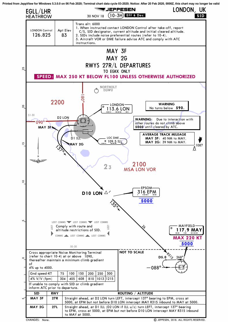
COMMS LOST COMMS LOST COMMS LOST
LOST
COMMS COMMS LOST COMMS LOST
LOST
NORTHOLTEGWU180^
090^
2200
2100MSA LON VOR
5000
5000
135^
137^
.SID.
JEPPESENEGLL/LHRHEATHROW 10-3H
LONDON, UK
05
1015
205
25Trans alt: 6000
MAYFIELD
M A Y117.9 MAYD
EPSOM316 EPME P M
113.6 LOND
LONDON
L O N
LOC DMEL O N
D2 LON
D1 ILL
MAY 3F
MAY 2G
D10 LON
1
26
R315 268^
NOT TO SCALE
088^
590.
5000
D5.0
* 109.5 ILL
30 NOV 18
Comply with route andaltitude restrictions of SID.
.Eff.6.Dec.
| JEPPESEN, 2018. ALL RIGHTS RESERVED.
LONDON Control
126.825Apt Elev
83
1087
None.
23
51-30
00-30
MAX 220 KT
MAX 250 KT BELOW FL100 UNLESS OTHERWISE AUTHORIZED.SPEED:
Cross appropriate Noise Monitoring Terminal(refer to chart 10-4) at or above
If unable to comply with SID or climb gradientinform ATC prior to departure.
27RMAY 3F
MAY 2G 27L
4% V/V (fpm)
75 100
405304
150
608 810 1013 1215
300250200Gnd speed-KT
RWYSID
1090,
TO EGKK ONLYRWYS 27R/L DEPARTURES
ROUTING / ALTITUDE
CHANGES:
thereafter maintain a minimum climb gradientof4% up to 4000.
Straight ahead, at D2 LON turn LEFT, intercept 137^ bearing to EPM, cross at5000, at EPM but not before D10 LON intercept MAY R315 inbound to MAY at 5000.Straight ahead, at D1 ILL (D2 LON if ILL u/s) turn LEFT, intercept 137^ bearingto EPM, cross at 5000, at EPM but not before D10 LON intercept MAY R315 inboundto MAY at 5000.
WARNINGNo turns below
WARNING: Due to interaction withother routes do not climb above
until cleared by ATC.
AVERAGE TRACK MILEAGEMAY 3F:MAY 2G:
40 NM to MAY.39 NM to MAY.
MAY 3FMAY 2G
1. When instructed contact LONDON Control after take-off, report C/S, SID designator, current altitude and initial cleared altitude.2. SIDs include noise preferential routes (refer to 10-4).3. Aircraft VOR or DME failure advise ATC and comply with ATCinstructions.
Printed from JeppView for Windows 5.3.0.0 on 06 Feb 2020; Terminal chart data cycle 03-2020; Notice: After 20 Feb 2020, 0000Z, this chart may no longer be valid

125^
R027
COMMS LOST COMMS LOST COMMS LOST
LOST
COMMS COMMS LOST COMMS LOST
LOST
NORTHOLTEGWU
180^
090^
2200
2100MSA LON VOR
5000
5000
D2 LON
D1.5 LON
113.6 LOND
LONDON
L O N
MAYFIELD
M A Y117.9 MAYD
R315 268^
088^
135^MAY 2K
MAY 2J
D3.5 LON
207^
.SID.
JEPPESENEGLL/LHRHEATHROW 10-3J
LONDON, UK
Trans alt: 6000
D20 MID
114.0 MIDD
MIDHURST
M I D
NOT TO SCALE
05
1015
205
25
5000
590.
1087
D5.0
30 NOV 18
Comply with route andaltitude restrictions of SID.
.Eff.6.Dec.
LONDON Control
126.825Apt Elev
83
| JEPPESEN, 2018. ALL RIGHTS RESERVED.Radial update.
23
51-30
00-30
MAX 220 KT
MAX 250 KT BELOW FL100 UNLESS OTHERWISE AUTHORIZED.SPEED:
09RMAY 2J
MAY 2K 09L
RWYSID
RWYS 09R/L DEPARTURESTO EGKK ONLY
4% V/V (fpm)
75 100
405304
150
608 810 1013 1215
300250200Gnd speed-KT1090,
Cross appropriate Noise Monitoring Terminal(refer to chart 10-4) at or above
ROUTING / ALTITUDE
If unable to comply with SID or climb gradientinform ATC prior to departure.
CHANGES:
thereafter maintain a minimum climb gradientof4% up to 4000.
WARNING: Due to interaction withother routes do not climb above
until cleared by ATC.
WARNINGNo turns below
AVERAGE TRACK MILEAGE37 NM to MAY.MAY 2J:38 NM to MAY.MAY 2K:
Straight ahead, at D2 LON turn RIGHT, intercept LON R125 to D3.5LON, turn RIGHT, intercept MID R027 inbound to D20 MID, cross at 5000, turn LEFT, intercept MAY R315 inbound to MAY at 5000.
Straight ahead, at D1.5 LON turn RIGHT, intercept LON R125 to D3.5LON, turn RIGHT, intercept MID R027 inbound to D20 MID, cross at 5000, turn LEFT, intercept MAY R315 inbound to MAY at 5000.
MAY 2JMAY 2K
1. When instructed contact LONDON Control after take-off, report C/S, SID designator, current altitude and initial cleared altitude.2. SIDs include noise preferential routes (refer to 10-4).3. Aircraft VOR or DME failure advise ATC and comply with ATCinstructions.
Printed from JeppView for Windows 5.3.0.0 on 06 Feb 2020; Terminal chart data cycle 03-2020; Notice: After 20 Feb 2020, 0000Z, this chart may no longer be valid

256^
240^
341^
FARNBOROUGHEGLF
FARNBOROUGHEGLF
FARNBOROUGHEGLF
COMMS LOST COMMS LOST COMMS LOST
LOST
COMMS COMMS LOST COMMS LOST
LOST
51-30
00-30
23
180^090^
2200
2100MSA LON VOR
60003000
60004000
60005000
6000
Apt ElevLONDON Control
133.180
D8 LON
161^
192^
BURNHAM421 BURB U R
.SID.
JEPPESENEGLL/LHRHEATHROW 10-3K
LONDON, UK
83
Trans alt: 6000
MIDHURST
M I D114.0 MIDD
113.6 LOND
LONDON
L O NMID 4F
MID 3G
D5LON
D5.5 LON
6
D12 LON
D17 LOND10 MID
10R0
12
NOT TO SCALE
590.
6000
05
1015
205
25
965
30 NOV 18
Comply with route andaltitude restrictions of SID.
.Eff.6.Dec.
| JEPPESEN, 2018. ALL RIGHTS RESERVED.Radial update.
MAX 250 KT BELOW FL100 UNLESS OTHERWISE AUTHORIZED.SPEED:
27RMID 4F
MID 3G 27L
4% V/V (fpm)
75 100
405304
150
608 810 1013 1215
300250200Gnd speed-KT
RWYSID
1090,
RWYS 27R/L DEPARTURES
Cross appropriate Noise Monitoring Terminal(refer to chart 10-4) at or above
ROUTING / ALTITUDE
If unable to comply with SID or climb gradientinform ATC prior to departure.
1. When instructed contact LONDON Control after take-off, report C/S, SID designator, current altitude and initial cleared altitude.2. SIDs include noise preferential routes (refer to 10-4).3. Cruising levels will be issued after take-off by LONDON Control.4. Do not climb above SID levels until instructed by ATC.
CHANGES:
thereafter maintain a minimum climb gradientof4% up to 4000.
Straight ahead, intercept LON R256 to D5 LON, turn LEFT, intercept 161^ bearingfrom BUR, cross D8 LON above 3000 (MAX 6000), D12 LON above 4000 (MAX 6000),turn RIGHT, intercept MID R012 inbound, cross D17 LON (D10 MID) above 5000(MAX 6000), then to MID at 6000.
WARNINGNo turns below
WARNING: Due to interaction withother routes do not climb above
until cleared by ATC.
AVERAGE TRACK MILEAGE
MID 3G: 30 NM to MID.MID 4F: 31 NM to MID.
Straight ahead, intercept LON R240 to D5.5 LON, turn LEFT, intercept 161^ bearingfrom BUR, cross D8 LON above 3000 (MAX 6000), D12 LON above 4000 (MAX 6000),turn RIGHT, intercept MID R012 inbound, cross D17 LON (D10 MID) above 5000(MAX 6000), then to MID at 6000.
MID 4FMID 3G
Printed from JeppView for Windows 5.3.0.0 on 06 Feb 2020; Terminal chart data cycle 03-2020; Notice: After 20 Feb 2020, 0000Z, this chart may no longer be valid

125^
COMMS LOST COMMS LOST COMMS LOST
LOST
COMMS COMMS LOST COMMS LOST
LOST
51-30
00-30
23
180^
090^
2200
2100MSA LON VOR
60003000
60004000
60005000
6000
6000
Apt ElevLONDON Control
30 NOV 18
133.180
D2 LON
D1.5 LON
113.6 LOND
LONDON
L O NMID 3K
MID 3J
D3.5 LON
114.0 MIDD
MIDHURST
M I D
207^
.SID.
JEPPESENEGLL/LHRHEATHROW 10-3L
LONDON, UK
83
Trans alt: 60000
510
1520
525
D19 MID
D15 MID
D12 MID
D8 MID
R027
4
3
4
8
590.
6000
1023
NOT TO SCALE
Comply with route andaltitude restrictions of SID.
.Eff.6.Dec.
| JEPPESEN, 2018. ALL RIGHTS RESERVED.Radial update.
MAX 250 KT BELOW FL100 UNLESS OTHERWISE AUTHORISED.SPEED:
09RMID 3J
MID 3K 09L
RWYSID
RWYS 09R/L DEPARTURES
75 100 150 300250200Gnd speed-KT
1090,
4000.MID 3J
MID 3K
5% V/V (fpm) 506380 760 1013 1266 1519
486365 729 972 1215 1458
405304 608 810 1013 12154% V/V (fpm)
Cross appropriate Noise Monitoring Terminal(refer to chart 10-4) at or above
ROUTING / ALTITUDE
If unable to comply with SID or climb gradientinform ATC prior to departure.
4.8% V/V (fpm)
thereafter maintain a minimum climb gradientof4% up to
5% until D19 MID due to ATC and airspace purposes.
4.8% until D19 MID due to ATCpurposes.
and airspace
WARNING
1. When instructed contact LONDON Control after take-off, report C/S, SID designator, current altitude and initial cleared altitude.2. SIDs include noise preferential routes (refer to 10-4).3. Cruising levels will be issued after take-off by LONDON Control.4. Do not climb above SID levels until instructed by ATC.
CHANGES:
Straight ahead, at D2 LON turn RIGHT, intercept LON R125 to D3.5 LON, turnRIGHT, intercept MID R027 inbound, cross D19 MID at or above 3000 (MAX 6000),D15 MID at or above 4000 (MAX 6000), D12 MID at or above 5000 (MAX 6000),D8 MID at 6000, then to MID at 6000.
Straight ahead, at D1.5 LON turn RIGHT, intercept LON R125 to D3.5 LON, turnRIGHT, intercept MID R027 inbound, cross D19 MID at or above 3000 (MAX 6000),D15 MID at or above 4000 (MAX 6000), D12 MID at or above 5000 (MAX 6000),D8 MID at 6000, then to MID at 6000.
No turns below
WARNING: Due to interaction withother routes do not climb above
until cleared by ATC.
AVERAGE TRACK MILEAGE29 NM to MID.
MID 3JMID 3K
Printed from JeppView for Windows 5.3.0.0 on 06 Feb 2020; Terminal chart data cycle 03-2020; Notice: After 20 Feb 2020, 0000Z, this chart may no longer be valid

071^
BIGGIB115.1
330^
136^
DTYYTD
D44.0
116.4
NORTHOLTEGWU
COMMS LOST COMMS LOST COMMS LOST
LOST
COMMS COMMS LOST COMMS LOST
LOST
D23.0
2100
180 ^
2200
090^
MSA LON VOR
60003000
60005000
6000
.SID.
JEPPESENEGLL/LHRHEATHROW 10-3M
LONDON, UK
05
1015
205
25Trans alt: 6000
113.6 LOND
LONDON
L O N
D2 LON
D1.5LON
050^
050^
ULTIB
1J
D10 LON
D20 BIG3
6000
590.
ULTIB
1087
Comply with route andaltitude restrictions of SID.
LONDON Control Apt Elev
83
ULTIB
1K
| JEPPESEN, 2018. ALL RIGHTS RESERVED.
119.780
28 DEC 18
HEMEL
BUZAD
10
10
329^
AWY continuation.
T420
23
51-30
00-30
.SPEED: MAX 250 KT BELOW FL100 UNLESS OTHERWISE AUTHORISED
09R
09L
4% V/V (fpm)
75 100
405304
150
608 810 1013 1215
300250200Gnd speed-KT1090,
RWY
RWYS 09R/L DEPARTURES
Cross appropriate Noise Monitoring Terminal(refer to chart 10-4) at or above
ROUTING / ALTITUDE
If unable to comply with SID or climb gradientinform ATC prior to departure.
ULTIB1J
ULTIB1K
SID
for ATM purposes.
thereafter maintain a minimum climb gradientof4% up to
CHANGES:
4000
WARNING: Due to interaction withother routes do not climb above
until cleared by ATC.
WARNINGNo turns below
ULTIB 1J [ULTI1J], ULTIB 1K [ULTI1K]
1. When instructed contact LONDON Control after take-off, report C/S,SID designator, current altitude and initial cleared altitude.2. SIDs include noise preferential routes (refer to 10-4).3. Cruising levels will be issued after take-off by LONDON Control.4. Do not climb above SID levels until instructed by ATC.5. EXPECT first CPDLC Data Link Authority to be EGTT.
AVERAGE TRACK MILEAGE18 NM to ULTIB.
Climb straight ahead, at D2 LON turn LEFT, 050^ track, intercept LON R071,cross D10 LON at or above 3000 (MAX 6000), turn LEFT, intercept BIG R330, crossD20 BIG at or above 5000 (MAX 6000), to ULTIB at 6000.
Climb straight ahead, at D1.5 LON turn LEFT, 050^ track, intercept LON R071,cross D10 LON at or above 3000 (MAX 6000), turn LEFT, intercept BIG R330, crossD20 BIG at or above 5000 (MAX 6000), to ULTIB at 6000.
NOT TO SCALE
Printed from JeppView for Windows 5.3.0.0 on 06 Feb 2020; Terminal chart data cycle 03-2020; Notice: After 20 Feb 2020, 0000Z, this chart may no longer be valid

176^
MIDD I M114.0
357^
154^
DTYYTD
D34.0
116.4
NORTHOLTEGWU
NORTHOLTEGWU
COMMS LOST COMMS LOST COMMS LOST
COMMS
LOST
COMMS LOSTCOMMS LOSTCOMMS LOST
COMMS
LOST
2100
180^
2200MSA LON VOR
090^
60003000
60004000
6000
Apt ElevLONDON Control
119.780
D3 LON
.SID.
JEPPESENEGLL/LHRHEATHROW 10-3N
LONDON, UK
05
1015
205
25
83
Trans alt: 6000
BURNHAM421 BURB U R 113.6 LON
DLONDON
L O NUMLAT
1F
UMLAT1G
298^
D4LOND7
LON
D8LON
356^
D10 LON
3
1
56000
590.
| JEPPESEN, 2017, 2018. ALL RIGHTS RESERVED.
UMLAT
If climb clearance or re-routinginstructions have not been given,comply with route and altitunderestrictions of SID; then viaT-418 to WOBUN, at WOBUNcommence climb to planned FL.
28 DEC 18
WOBUN
21
AWY continuation.
T418
23
51-30
00-30
MAX 250 KT BELOW FL100 UNLESS OTHERWISE AUTHORISED.SPEED:
27R
27L
RWYSID
4% V/V (fpm)
75 100
405304
150
608 810 1013 1215
300250200Gnd speed-KT1090,
RWYS 27R/L DEPARTURES
Cross appropriate Noise Monitoring Terminal(refer to chart 10-4) at or above
UMLAT1F
UMLAT1G
ROUTING / ALTITUDE
If unable to comply with SID or climb gradientinform ATC prior to departure.for ATM purposes.
thereafter maintain a minimum climb gradientof4% up to
CHANGES:
4000
Climb straight ahead, intercept 298^ bearing towards BUR by D4 LON to D7 LON,turn RIGHT, intercept 356^ bearing from BUR (MID R357), cross D8 LON at or
WARNING: Due to interaction withother routes do not climb above
until cleared by ATC.
WARNINGNo turns below
1. When instructed contact LONDON Control after take-off, report C/S, SID designator, current altitude and initial cleared altitude.2. SIDs include noise preferential routes (refer to 10-4).3. Cruising levels will be issued after take-off by LONDON Control.4. Do not climb above SID levels until instructed by ATC.5. EXPECT first CPDLC Data Link Authority to be EGTT.
UMLAT 1F [UMLA1F], UMLAT 1G [UMLA1G]
AVERAGE TRACK MILEAGE16 NM to UMLAT.
above 3000 (MAX 6000), D10 LON at or above 4000 (MAX 6000), to UMLAT at 6000.
Climb straight ahead, intercept 298^ bearing towards BUR by D3 LON to D7 LON,turn RIGHT, intercept 356^ bearing from BUR (MID R357), cross D8 LON at orabove 3000 (MAX 6000), D10 LON at or above 4000 (MAX 6000), to UMLAT at 6000.
NOT TO SCALE
Printed from JeppView for Windows 5.3.0.0 on 06 Feb 2020; Terminal chart data cycle 03-2020; Notice: After 20 Feb 2020, 0000Z, this chart may no longer be valid

256^
240^ 125^
071^
D5LON
MAY 2J, 2KMID 3J, 3K
D3LON
For AIRPORT BRIEFINGrefer to 10-1P pages
BPK7F, 7GUMLAT1F, 1G
D5LON
D6 L
ON
D7 L
ON
MID
4F, 3G
Apt Elev
83'
EGLL/LHRHEATHROW
LONDON, UK.NOISE.10-4
| JEPPESEN, 2004, 2019. ALL RIGHTS RESERVED.
6
A
C
D
E
F
G
I
09L
09R
27R
27L
H
B 050^
050^
122^121^
D10 L
ON
137^
CPT 4K CPT
5J
D3.5 LON
D20 MID
298^
281^
1J ,1K
D2 OCK
D7 L
ON
D19 MID
BPK
5K, U
LTIB
1K
BPK
6J, U
LTIB
1J
D4 LON
D5.5 LON
MID 3G
J
51-30
00-2000-3005
5
D8 LON
JEPPESEN
6
A
C
D
E
F
G
H
- 6m - 0.3
- 4m + 2.3
- 7m - 1.0
- 6m
- 7m
- 0.3
- 0.6
- 3m
- 3m
+ 0.9
- 0.1
- 3m + 1.2
I - 4m - 0.3
B - 4m + 4.8
N51 27.9 W000 32.0
N51 29.0 W000 31.4
N51 28.7 W000 31.3
N51 28.2 W000 31.8
N51 27.8 W000 32.0
N51 27.4 W000 32.3
N51 28.4 W000 23.8
N51 28.1 W000 23.6
N51 27.8 W000 23.7
N51 27.2 W000 23.7
Thames Water, Wraysbury
Colnbrook
Poyle
Horton
Coppermill
Wraysbury Reservoir (South)
Hounslow West
Hounslow Heath
East Feltham
ELEVATIONABOVE
AERODROME
ADJUSTMENTdb(A)NOISE MONITORING TERMINAL/LOCATION/NAME
J - 3m - 0.2N51 28.2 W000 23.6
Hounslow Cavalry Barracks
Hounslow Cavalry Barracks North
DET 1J
DET 1K
DET 2F
MAY 3F
DET 2GMAY 2G
161^
103^
CPT 3F
GOGSI 1F
MID 4F
CPT 3GGOGSI 1G
GA
SGU
D2.0 LOND1.5LON
D1.0 ILL
2.0 LON D
4.0
LO
N
6 SEP 19
Reissue.
If the aircraft was required to take-off with a tailwind an amount of thenoise recorded at the noise monitor should be disregarded.
Amount to be disregarded
Tailwind component 1 KT
0.4 dB
2 KT
0.8 dB
3 KT
1.2 dB
4 KT
1.6 dB
4 KT
2.0 dB
CHANGES:
NOISE ABATEMENT
LON
ILL
EPM
WOD
DET
412'
1Noise monitoring terminal
The operational limits as specified on Airport Briefing Pages shall be adjusted in respectof any noise monitoring terminal to take account of the location and its ground elevationrelative to the aerodrome elevation as follows:
Printed from JeppView for Windows 5.3.0.0 on 06 Feb 2020; Terminal chart data cycle 03-2020; Notice: After 20 Feb 2020, 0000Z, this chart may no longer be valid

| JEPPESEN, 2019. ALL RIGHTS RESERVED.
JEPPESEN LONDON, UKHEATHROW
EGLL/LHR
REFER ALSO TO LATEST NOTAMS
A
A
L
B
L
TAXIWAY RESTRICTIONS
New temporary chart.
LINK26
LINK27
K1
A
19 JUL 19
Twy B, between twy K and twy L will be permanentely closed and the following route will be not available:- East and west along twy B between twy K and twy L. Block 715 on twy B, between Link 29 and Link 27 will be temporarily closed when rwy 27L is not in use for departures and the following routes will be not available:- East and west along twy B between twy L and Link 28.- East and west along Link 28 between twy A and twy B.- North and south along Link 29 between twy A and twy B.- North and south along twy B between Link 27 and Link 29.- North and south along twy B between Link 27 and Link 28.- East and west on twy B between Link 28 and Link 29. Exact date and time of each closure will be issued by NOTAM.
Operational limitations:
B
10-8
Rehabilitation of two grass areas takes place north of twy B.
TERM
INA
L 2B
TERM
INA
L 2A
AW2
K1
L1
LOMAN
MORRA
AE2
BQ1
NEVIS
CHANGES:
K
K
LINK28
LINK29
LINK30
LEGEND
Ground reportingpoint
HOT SPOTsee 10-9A fordescription
HS3
HS3
Printed from JeppView for Windows 5.3.0.0 on 06 Feb 2020; Terminal chart data cycle 03-2020; Notice: After 20 Feb 2020, 0000Z, this chart may no longer be valid

Apt Elev
AB13
A1
NB11
S11
N11
For
AIR
PO
RT B
RIE
FIN
G r
efe
r to
10-1
P p
ages
Y
10-9
51-28
51-28
51-29
51-29
00-26
00-27
00-27
00-28
00-28
00-29
00-29
A13
L57
S
S6S
A3
A2
AL2
1
L23
L23
M
W
W
S3S
L43
L42
L44
L56
| JEPPESEN, 2007, 2019. ALL RIGHTS RESERVED.
NB1
0N
10
A
NB8
A
DN
7
AA
N4E
N5E
N5W
SB3
A7
A6
A5
A
A4
L13
L27
L53
L52
AA
L L
A10
EA
9W
B
L58
B
AB12
C C
A
B
D DB
D
A10
W B
E
C
Con
trol
Tow
er
B
EF
F
A9E
A8
AL1
1
L32
L33
L34
BL3
5
L51
AB11
L55
L54BA
12A
11
Y
A
B
L26
JEPPESEN
N1
NB1
B
NB2E
N2E
AN
2WN
B2W N
3N
B3
A
BL
B
L60
S5W
S5ES4
WS4
E
TM
NL
2B
N4W
00-26
PIE
R 4
A
S
L41
S1
LEG
END
Link
12
L12For
DE-I
CIN
G A
REA
Ssee 1
0-9
G.
De-
icin
g JE
DI
(Del
ta)
(Sou
th)
KB
N6
L25
L12
AVRO
ES7
Y
A
15 MAR 19
VA
R 0^
.Eff.28.Mar.
Construction area revised.
TM
NL
5A
TM
NL
2A
TM
NL
1
N8TM
NL
5B
TM
NL
5C
L22
A
L36
De-
icin
g JE
DI
De-
icin
gVA
DER
(Nor
th)
De-
icin
gVA
DER
(Sou
th)
EGLL/LHR LONDON, UK
09L
27R
Elev
090^
270^
78'
N51 28.7 W000 27.783'
*HEATHROW Delivery (Cpt) *Ground Tower
27L
MA
INTENA
NCE
270^
TERM
INA
L 4
CA
RG
OA
PRO
N
T
09R
090^
Elev 75'
*D-ATIS Departure
HEATHROW
CHANGES:
12,008
'
CA
RG
OTERM
INA
L
SUIT
ERO
YA
L
CA
RG
OA
PRO
NZ
AREA
1
3660
m
78'
Elev
77'
Elev
VT
FO
R D
ETA
ILS
SEE 1
0-9
D
121.935
R
12,802
'39
02m
L28
ARP
PIER 5
H
PIE
R 6
PIER 7
H
G TM
NL
3
G
R
SEE 1
0-9
C
0 020
040
060
080
010
00
1000
2000
3000
4000
1200
Feet
Meters
L28
L30
L31
K KL2
9
BEA
LINE
BA
SE
FO
R D
ETA
ILS
121.980 121.855121.905 121.705 118.705118.505
HO
T SP
OT
See
10-9
A f
orde
scri
ptio
n
HS2
HS1
HS1
HS3
HS4
Printed from JeppView for Windows 5.3.0.0 on 06 Feb 2020; Terminal chart data cycle 03-2020; Notice: After 20 Feb 2020, 0000Z, this chart may no longer be valid

EGLL/LHR LONDON, UKHEATHROW10-9A
(60m) (15m)
(60m) (15m)
(60m) (15m)
JEPPESEN
| JEPPESEN, 2007, 2018. ALL RIGHTS RESERVED.
TAKE-OFF
ABCD
Day: RL or RCLMNight: RL or CL (Day only)
Adequate vis refHIRL, CL &relevant RVR
RL, CL &relevant RVR RL & CL
Day: RL & RCLMNight: RL or CL
Low Visibility Take-off
.Standard.
TDZ, MID, RO TDZ, MID, RO
RVR125m 150m 200m 400m 500mRVR RVR 300mRVR
1 RVR 75m with approved guidance system or HUD/HUDLS.
1
15 MAR 19 .Eff.28.Mar.
None.CHANGES:
SEQUENCING OF AIRCRAFT GROUND MOVEMENTSFOR TAKE-OFF IN LOW VISIBILITY
AIRCRAFT TAKE-OFF MINIMA MINIMUM RVR FOR START-UP
When the reported RVR is below 400m do not request start-up until the reported RVR is equal to orgreater than the appropriate value as shown below:
350m RVR300m RVR250m RVR200m RVR150m RVR100m RVR75m RVR
300m250m200m150m150m100m75m
RWY
ADDITIONAL RUNWAY INFORMATION
ThresholdLANDING BEYOND
USABLE LENGTHS
WIDTHTAKE-OFFGlide Slope
RVR09R27L
164'50m
10,991' 3350m
10,907' 3324m
3035m5
RVR09L
27R164'50m
11,785' 3592m
11,642'3548m
5 TAKE-OFF RUN AVAILABLERWY 27L:
12,736' 3882m
10,813'3296m
HIRL TDZCL HIALS-II PAPI-L(3.0^)
HIRL CL HIALS-II TDZ PAPI-L(3.0^)
RWY 09R:
RVRHIRL TDZCL HIALS-II PAPI-L(3.0^)4
4 HST - N6
9958'
TAKE-OFF RUN AVAILABLERWY 09L:
2RWY 27R:
21
3
1 RWY grooved.
3 RWY grooved.
12,799' (3901m)11,030' (3362m)
9311' (2838m)8730' (2661m)7723' (2354m)6535' (1992m)5869' (1789m)
From rwy headtwy A12 inttwy A11 int
twy A10W inttwy A10E int twy A9W inttwy A9E int
12,001' (3658m)11,575' (3528m)10,994' (3351m)
9360' (2853m)9357' (2852m)7628' (2325m)7362' (2244m)5591' (1704m)
12,001' (3658m)11,601' (3536m)11,089' (3380m)10,577' (3224m)10,538' (3212m)
8865' (2702m)8550' (2606m)8494' (2589m)8009' (2441m)7290' (2222m)6860' (2091m)6827' (2081m)
From rwy headtwy N2E int
twy N2W inttwy N3 inttwy S3 int
twy N4E inttwy S4W inttwy S4E int
twy N4W inttwy S5E inttwy N5E inttwy S5W int
From rwy headtwy N10 inttwy N8 inttwy S7 inttwy N7 inttwy N6 inttwy S6 int
twy N5W int
From rwy headtwy A4 inttwy A5 inttwy A6 inttwy A7 inttwy A8 int
twy A9E inttwy A9W int
12,736' (3882m)11,611' (3539m)10,289' (3136m)
9390' (2862m)8586' (2617m)7920' (2414m)7028' (2142m)6388' (1947m)
(For information only, not to be construed as ATC instructions.)
Pilots are to maintain a good lookout at all times and are responsible for wing tip clearance.
HOT SPOTS
Pilots of Code F ACFT must take care - Link 28 East of TWY A is not Code F compliant.
Pilots are to ensure they have clearance to enter the runway before crossing the holding point.
HS1
HS2
HS3
HS4
Printed from JeppView for Windows 5.3.0.0 on 06 Feb 2020; Terminal chart data cycle 03-2020; Notice: After 20 Feb 2020, 0000Z, this chart may no longer be valid

SY6
AB13
A10
EA
9WA
1
NB11
S11
N11
N10
Y
A13
AB
A12
S
C C
N8
NB8
A
A
B
S6
N7
A
D D
AB
D
A10
W
B
E
C
Con
trol
Tow
er
B
EF
F
A
S
N4E
N5E
N5W
SB3
A9E
A8
A7
A6
A5
A3
A
B
A2
AA
B
M
N2E
W
S3
S
A
A11
NB10
00-28
00-27.5
00-27
00-26.5
00-28.5
00-29
00-26
51-28.7
51-28.2
51-28.1
51-27.8
51-27.7
51-28.8
51-29
51-27.9
51-28.9
51-27.6
51-27.5
51-27.4
51-27.3
00-28
00-27.5
00-27
00-26.5
00-28.5
00-29
00-26
51-28.7
51-28.6
51-28.2
51-28.1
51-28
51-27.8
51-27.7
51-28.8
51-29
51-27.9
51-28.9
51-27.6
51-27.5
51-27.4
51-27.3
Link 4
4
Link
42
F2
AY4
TITA
N
Link
11
Link
13
Link
23
Link
23
AY3
AY1
Link
21
LOKKI
SATU
N
Link
33
Link
32
Link
34
Link 5
3
Link 5
2
Link
51
M1
B
F1E1
Link
58
Link 5
7
MO
RRA
Runw
ay H
oldi
ngA
reas
BB
A
A
E1
S
AB12
AB11
TM
NL
5B
BA
Y
Link
55
Link
54
Y
L L
AY10
C2
D1
C1
D2
TM
NL
5C
JEPPESEN
A
N1 NB1
A
A
L2
B
Link 2
8
A N2W
NB2W
N3
NB3
LOM
AN
Link
28
L
BB
26
Link
31
Link
30
Link
29
B
Link
35
Link
60
B
S5W
S5E
S4W
S4E
K1
TM
NL
2B
SY5
SQ5
SY4
N4W
S
S1SQ
4N
ESSY
TULL
A
For
DE-I
CIN
G A
REA
Ssee 1
0-9
G.
K
N6
25
Link
12
AVRO
ES7
AY5
Non
e.
30 A
UG
19
.Eff.12.Sep.
TM
NL
3
TM
NL
5A
Link
43
Link 22
Link 2
7
NB2E
E2
Link
36
AE2
AW
2
L1
BQ
1N
EVIS
BY2
BQ
2
BY1
Link 4
1
B1
TM
NL
1
TM
NL
2A
A4
ARP
TERM
INA
L 4
CA
RG
OA
PRO
N
T
PIER
5
CA
RG
OTERM
INA
L
SUIT
ERO
YA
L
CA
RG
OA
PRO
NZ
H
PIE
R 6
PIER
7
H
GG
R R
PIE
R 4
A
V
T
51-28.5
LEG
END
RWY 0
9L/2
7R
RWY 0
9R/2
7L
CHA
NG
ES:
10-9
BLO
NDON, UK
HEA
THRO
WEG
LL/LHR Link 5
6
| J
EPPE
SEN
, 20
08,
2019
. A
LL R
IGHTS
RES
ERVED
.
K KK
SNA
PA
OST
ER HO
RKA
Gro
und
repo
rtin
g
RABIT
CO
BRA
DIN
GO
VIK
AS
DA
SSO
HA
NLI
poin
t
Link
HO
T SP
OT
see
10-9
A f
orde
scri
ptio
n
Link
PLUTO
HS2
HS1
HS1
HS3
HS4
Printed from JeppView for Windows 5.3.0.0 on 06 Feb 2020; Terminal chart data cycle 03-2020; Notice: After 20 Feb 2020, 0000Z, this chart may no longer be valid

HS1
Link
42
Link
51
311 30
9
325
307 30
5L
303 30
3R30
5
303L
305R
N5W
Link
34
Link
32
Link
N5E
33
301
00-28
00-27.5
00-27
00-26.5
00-28.5
00-28
00-27.5
00-27
00-26.5
00-28.5
51-28
51-28.6
51-28.1
51-28.2
51-28.4
51-27.8
51-27.7
51-27.5
51-27.4
51-28.7
51-27.8
51-27.6
51-27.5
51-27.4
51-28.7
Link 4
4Li
nk 4
1
LEG
END
C C
A12
NB8
N8
N7
A11
Gro
und
repo
rtin
g
BA
A3
L21
A
A2
L22L2
3
M
A1
L23
AA
Y1
M1
SATU
N
00-25.8
00-26
51-28.6
00-26.1
00-25.9
00-25.7
AY3
S
AB12
AB11
C2 C1
D2
E1
JEPPESEN
L2
Link
30
Link
31
poin
t
Link
29
SEE INSET
HO
T SP
OT
see
10-9
A f
orde
scri
ptio
n
N4W
N4E
S4E
S5E
Link 1
3
For
DE-I
CIN
G A
REA
Ssee 1
0-9
G.
N6
Link 1
2
30 A
UG
19
.Eff.12.Sep.
323
Stan
ds 3
23 a
nd 5
81 e
stab
lish
ed.
TERM
INAL 1
PIER
5
TERM
INA
L 2A
TERMINAL 2B
SY6
Link
36
A4
327
330
332
334
ARP
A9W
326
335
A8
A7
313
A9E
A
A5
A6
316
317
318
319
320
321
322
364
F F1
329
331
A
B
A10
E
A
F2
E233
6
342
363
365
F
H
PIER
7
G
Tow
er
GCon
trol
A
592
594
596
595
E
590 58
3
E1
591
A10
W
10-9
CLO
NDON, UK
HEA
THRO
WEG
LL/LHR
51-28.6
SB3
S6
Link
43
412
414
415
416
601
W
S
S3
CA
RG
OA
PRO
N
602
603
604
605
606
SS
AB
D DDC
B
567
568
566
576
582
A
B
51-28.4
A
565
575A B
B A
AY10
D1
561
562
| J
EPPE
SEN
, 20
08,
2019
. A
LL R
IGHTS
RES
ERVED
.
Link 2
7
MO
RRA
B
AY4
B
L
TITA
N
51-28.4
B
L
258
257
256
357R
353
328
35735
7L
351
H
PIE
R 4
A
355
LOKKI
Link 2
8
L
249
248
247
Link
26
255
A NB2WN2W
NB3
N3
B
LOM
AN
A
AW
2
231
232
233L 23
323
3R
247R
247L
258L
258R
K
563
564
573
572
Link
35
340
S4W
S5W
216
217
218
219
220
221
223
224
225
226
236
238
239
241
242
243
244
246
251
252
253
254
254L
253L
243R 243L
246L
246R
254R
253R
236R
236L
218R
218L
221R
221L
K1
K
CHA
NG
ES:
340R340L
SY5
SQ5
SY4
L1
255L 25
5R
NEV
ISBY2
BQ
2
BY1
BQ
1
SQ4
TULL
A
NES
SY
B1
K
B
Link
25
21021
0L21
0R
209
209R
209L
AVRO
ES7
Link
60
K
Link 1
1
AY5
PLUTO
211
212R
212
212L
213L
213
213R
581
CA
RG
OTERM
INA
L
R
RWY 0
9L/2
7R
PIE
R 6
R
RWY 0
9R/2
7L
403
SUIT
ERO
YA
L
405
406
450
461
452
453
454
455
456
440
441
42242
342442
5
TERM
INA
L 4
401
402
40740
8
409
410
411
417
419
420
421
T
V
T
607
608
609
CA
RG
OA
PRO
N
611
612
613
614
615
616
Z
553
552
551
541
547R 54
7L
546L
546R 54
5L
545R
544R 54
4L
542
543
544
545
546
547
554
555
556
548R 54
8L54
8
539
538
537
536
535
534
533
532
531
558
557
449
451
410R41
0L
457L
457
457R
429
430
431
432
701
702
27R
270^
TERM
INAL 3
TERMINAL 5B
TMNL 5C
OST
ER
HO
RKA
SNA
PA
RABIT
HS2
HS1
Printed from JeppView for Windows 5.3.0.0 on 06 Feb 2020; Terminal chart data cycle 03-2020; Notice: After 20 Feb 2020, 0000Z, this chart may no longer be valid

AB13
NB11
S11
N11N10
Y
A13
A
A12
C
N8
NB8
A
B
C
A
NB10
Link 53
Link 52
Link 57
B
A
AB12
Link 56
BA
Y
TERMINAL 5B
Link51
Link58
Link55
Link54
51-28
51-28.6
51-28.1
51-28.2
51-28.3
51-27.8
51-28.5
51-27.9
51-28.4
00-29.4
00-2900-28.9 00-28.8 00-28.700-29.100-29.300-29.4
51-28
51-28.6
51-28.2
51-27.8
51-28.5
51-27.9
51-28.4
10-9D
Y
B
A
C
JEPPESEN
| JEPPESEN, 2008, 2019. ALL RIGHTS RESERVED.
51-28.3
Link60
30 AUG 19 .Eff.12.Sep.
Stand 517 established.
TERMINAL 5A
00-2900-28.9 00-28.8 00-28.700-29.100-29.200-29.3
RWY 09R/27L
RWY 09L/27R
553
552
551541
542
543
554
555
556
548
539
538
537
536
535
534
533
532
531
548R
548L
547547R
547L
546546R
546L
545545R
545L
544544R
544L
509
508
507
506
512
511
513514
515516
518
519520521522523
524 525 526 527
501502 503 505
LONDON, UKHEATHROW
EGLL/LHR
CHANGES:
557
558
517
SNAPA
DINGO
RABIT
COBRA
DASSO
HORKA
OSTER
HANLI VIKAS
LEGENDGround reporting
OSTER
C1
C2
point
HOT SPOT see 10-9Afor description
HS 4
HS 4
Printed from JeppView for Windows 5.3.0.0 on 06 Feb 2020; Terminal chart data cycle 03-2020; Notice: After 20 Feb 2020, 0000Z, this chart may no longer be valid

10-9E
| JEPPESEN, 1999, 2019. ALL RIGHTS RESERVED.
JEPPESEN
30 AUG 19 .Eff.12.Sep.
Stand 323 coordinates established.
LONDON, UKHEATHROW
EGLL/LHR
CHANGES:
INS COORDINATES
STAND No. COORDINATES STAND No. COORDINATES
211
216 thru 218R
219, 220
225, 226 231 thru 233R
236 thru 238 239 241
242 thru 243R
247L
251 252 thru 253R
258L
303L
N51 28.4 W000 27.0N51 28.5 W000 27.0N51 28.4 W000 26.9
N51 28.5 W000 26.8
N51 28.4 W000 26.8
N51 28.2 W000 26.8
N51 28.1 W000 26.8N51 28.1 W000 26.9
N51 28.1 W000 27.1 N51 28.4 W000 26.6
N51 28.2 W000 26.6N51 28.1 W000 26.6N51 28.1 W000 26.5N51 28.2 W000 26.5
N51 28.4 W000 26.6N51 28.3 W000 26.5N51 28.4 W000 26.5
N51 28.1 W000 26.3 N51 28.2 W000 26.3N51 28.3 W000 26.3N51 28.4 W000 26.3 N51 28.5 W000 26.3N51 28.1 W000 27.3N51 28.1 W000 27.4
305, 305L/R307
309311313
316
319320
323
326327
328329
N51 28.1 W000 27.4N51 28.1 W000 27.5
N51 28.1 W000 27.6N51 28.2 W000 27.6N51 28.1 W000 27.7
N51 28.1 W000 27.8N51 28.2 W000 27.8
N51 28.2 W000 27.9N51 28.2 W000 27.8
N51 28.2 W000 27.9N51 28.2 W000 27.6
N51 28.4 W000 27.7N51 28.3 W000 27.7
N51 28.4 W000 27.7N51 28.3 W000 27.7N51 28.4 W000 27.8
N51 28.4 W000 27.9N51 28.4 W000 28.0
N51 28.5 W000 27.6
N51 28.4 W000 27.5
N51 28.3 W000 27.9
301, 303, 303R
317, 318
321, 322
330 thru 335
336, 340
N51 28.4 W000 27.9340L
340R, 342N51 28.4 W000 27.5351
353, 355
363 thru 365
209, 209R209L
N51 28.5 W000 26.9210L
212, 212L/RN51 28.4 W000 26.9213
213L N51 28.3 W000 26.8213R N51 28.4 W000 26.8
N51 28.1 W000 26.8218L
221, 221RN51 28.1 W000 27.0221L thru 224
244 thru 246R
N51 28.3 W000 26.6N51 28.3 W000 26.5246L
247, 247R
248
249 N51 28.4 W000 26.6
254 thru 255R256 thru 258R
210, 210R
N51 28.5 W000 27.5357
357L, 357R
325 N51 28.3 W000 27.7
Printed from JeppView for Windows 5.3.0.0 on 06 Feb 2020; Terminal chart data cycle 03-2020; Notice: After 20 Feb 2020, 0000Z, this chart may no longer be valid

10-9F
| JEPPESEN, 1999, 2019. ALL RIGHTS RESERVED.
JEPPESEN
30 AUG 19 .Eff.12.Sep.
Stands 517 and 581 coordinates established.
LONDON, UKHEATHROW
EGLL/LHR
CHANGES:
INS COORDINATES
STAND No. COORDINATES STAND No. COORDINATES
N51 27.5 W000 26.9N51 27.5 W000 27.0N51 27.6 W000 27.0
N51 27.6 W000 26.9N51 27.7 W000 26.8
N51 27.7 W000 26.7N51 27.8 W000 26.6N51 27.7 W000 26.7
N51 27.6 W000 26.7N51 27.6 W000 26.5
N51 27.7 W000 26.5N51 27.8 W000 26.5
N51 27.7 W000 26.4N51 27.7 W000 26.3N51 27.7 W000 27.1
N51 27.5 W000 27.3 N51 27.6 W000 27.3
N51 27.7 W000 27.3
N51 27.5 W000 27.1
N51 28.4 W000 29.4N51 28.4 W000 29.3N51 28.4 W000 29.2N51 28.3 W000 29.2
N51 28.2 W000 29.2
N51 28.2 W000 29.1N51 28.2 W000 29.2
N51 28.1 W000 29.3
N51 28.1 W000 29.2N51 28.4 W000 28.9
N51 28.3 W000 28.9N51 28.2 W000 28.9N51 28.1 W000 28.9
N51 28.1 W000 28.8
401
407
408, 409 410 thru 411
412414
415 thru 420
421422, 423
424, 425429
430431, 432440, 441
449 thru 452453, 454
461501
506 thru 509511 thru 515
519520, 521
526, 527
536, 537538, 539
541, 542
455N51 27.7 W000 27.4456 thru 457R
458 N51 27.8 W000 27.4
502 thru 505
522, 523 N51 28.2 W000 29.3524, 525
543 thru 544R545L thru 546R547L thru 548R
551
552 thru 554555, 556557, 558561, 562563, 564
565, 566567, 568
572573
575, 576
583590 thru 592
594595, 596
601602, 603
604605, 606
607
608, 609611, 612
613614
701, 702
N51 28.2 W000 28.8N51 28.3 W000 28.8N51 28.4 W000 28.8N51 28.1 W000 28.6
N51 28.2 W000 28.6N51 28.3 W000 28.6N51 28.4 W000 28.6N51 28.4 W000 28.5N51 28.3 W000 28.5
N51 28.2 W000 28.5N51 28.1 W000 28.5N51 28.4 W000 28.3N51 28.3 W000 28.3N51 28.2 W000 28.3
N51 28.1 W000 28.3N51 28.1 W000 28.2N51 28.2 W000 28.2N51 28.3 W000 28.2N51 28.4 W000 28.2
N51 27.7 W000 27.5N51 27.7 W000 27.6N51 27.7 W000 27.7N51 27.7 W000 27.8N51 27.7 W000 27.9
N51 27.7 W000 28.0N51 27.7 W000 28.3N51 27.6 W000 28.3N51 27.6 W000 28.4N51 27.7 W000 28.5
N51 28.4 W000 25.8N51 27.7 W000 28.4
615
616
402 thru 406
531, 532533 thru 535
516 thru 518
581, 582
Printed from JeppView for Windows 5.3.0.0 on 06 Feb 2020; Terminal chart data cycle 03-2020; Notice: After 20 Feb 2020, 0000Z, this chart may no longer be valid

AB13
A1
NB11
S11
N11
Y
A13
L57
S
S6
S
A3
A2
L21
L23
L23
M
W
W
S3S
L43
L42
L44
L56
N10
A
NB8
A
DN
7
AA
N4E
N5E
N5W
SB3
A7
A6
A5
A B
A4
L13
L27
L53
L52
AA
L L
A10
EA
9W
B
L58
B
AB12
C C
A
B
D DB
D
A10
W
B
E
C
Con
trol
Tow
er
B
EF
F
A9E
A8
AL1
1
L32
L33
L34
B
L35
L51
AB11
L55
L54
BA12
A11
Y
A
B
L26
JEPPESEN
N1 NB1
B
NB2E
N2E
AN
2WN
B2W
N3
NB3
A
BL
B
L60
S5W
S5ES4
WS4
E
TM
NL
2B
N4W
PIE
R 4
A
S
L41
S1
LEG
END
Link
12
L12
De-
icin
g JE
DI
(Del
ta)
(Sou
th)
10-9G
09L/
27R
09R/
27L
NB10 De-
icin
g ar
ea
D1
D1
BY1
BQ
2
BY2
A
D2
K
N6
L25
L12
S7A
VRO
E
Y
A
| JEPPESEN, 2017, 2019. ALL RIGHTS RESERVED.None.
30 AUG 19 .Eff.12.Sep.
TM
NL
5A
TM
NL
3
TM
NL
2A
TM
NL
1
N8T
MNL
5B
TM
NL
5C
L22
L36
De-
icin
g JE
DI
De-
icin
gVA
DER
(Nor
th)
De-
icin
gVA
DER
(Sou
th)
NEV
IS
BQ
1
EGLL/LHR LONDON, UK
TERM
INA
L 4
CA
RG
OA
PRO
N
T
HEATHROW
CHANGES:
CA
RG
O
TERM
INA
L
SUIT
E
RO
YA
L
CA
RG
O
APRO
NZ
VT
R
L28
ARP
PIER 5
H
PIE
R 6
PIER 7
H
GG
R
L28
L30
L31
K KL2
9
BEA
LINE
BA
SE
HO
T SP
OT
See
10-9
A f
or d
escr
ipti
on
Gro
und
repo
rtin
g po
int
HS2
HS1
HS1
HS3
HS4
Printed from JeppView for Windows 5.3.0.0 on 06 Feb 2020; Terminal chart data cycle 03-2020; Notice: After 20 Feb 2020, 0000Z, this chart may no longer be valid

CHANGES:
STRAIGHT-IN RWY
10-9Y.STD.COPTER.MINIMUMS.
DA(H) / MDA(H) RVR (ALS/ALS out)
150m 200m 200m 800m
Unlit/unmarkeddefined
RWY/FATO
1
250m21
2
Nil FacilitiesDAY
Nil FacilitiesNIGHT
EGLL/LHRLONDON, UK
HEATHROW
09L
09R
27L
27R
JEPPESEN
| JEPPESEN, 2001, 2019. ALL RIGHTS RESERVED.
15 FEB 19
CAT 2 ILS DMEILS DME
LOCRNAV (LNAV/VNAV)
RNAV (LNAV)
178' (100')278' (200')640' (562')510' (432')640' (562')
RA 102' - 300m 500m / 1000m 1000m / 1000m 750m / 1000m1000m / 1000m
CAT 2 ILS DMEILS DME
LOCRNAV (LNAV/VNAV)
RNAV (LNAV)
177' (100')277' (200')640' (563')510' (433')640' (563')
RA 102' - 300m 500m / 1000m1000m / 1000m 750m / 1000m1000m / 1000m
CAT 2 ILS DMEILS DME
LOCRNAV (LNAV/VNAV)
RNAV (LNAV)
175' (100')275' (200')480' (405')500' (425')630' (555')
RA 100' - 300m 500m / 1000m 800m / 1000m 750m / 1000m1000m / 1000m
CAT 2 ILS DMEILS DME
LOCRNAV (LNAV/VNAV)
RNAV (LNAV)
179' (100')279' (200')470' (391')570' (491')630' (551')
RA 100' - 300m 500m / 1000m 800m / 1000m 750m / 1000m1000m / 1000m
Minimums.
RL/FATO LTS,RCLM &RVR info
RL/FATO LTS& RCLM
Low Visibility Take-off
MDA(H)CIRCLE-TO-LAND VIS
1000m
Or rejected take-off distance whichever is the greater.
750' (667')
TAKE-OFF RWY 09L/R, 27L/R
Without Low Visibility Take-off approval 400m are stipulated.
Printed from JeppView for Windows 5.3.0.0 on 06 Feb 2020; Terminal chart data cycle 03-2020; Notice: After 20 Feb 2020, 0000Z, this chart may no longer be valid

CHANGES:
STRAIGHT-IN RWY
10-9Y1
DA(H) / MDA(H) RVR (ALS/ALS out)
150m 200m 200m 800m250m21
2
EGLL/LHRLONDON, UK
HEATHROW
09L
09R
27L
27R
JEPPESEN
450' (371')620' (541')
400' (325')620' (545')
750m / 1000m1000m / 1000m
380' (303')640' (563')
750m / 1000m1000m / 1000m
380' (302')640' (562')
750m / 1000m1000m / 1000m
RNAV Y (LNAV/VNAV)RNAV Y (LNAV)
RNAV Y (LNAV/VNAV)RNAV Y (LNAV)
RNAV Y (LNAV/VNAV)RNAV Y (LNAV)
RNAV Y (LNAV/VNAV)RNAV Y (LNAV)
Unlit/unmarkeddefined
RWY/FATO
1Nil Facilities
DAYNil Facilities
NIGHT
Low Visibility Take-off
RL/FATO LTS, RCLM &RVR info
RL/FATO LTS & RCLM
750m / 1000m1000m / 1000m
STD.COPTER.MINIMUMS.29 JUN 18
LNAV rwy 27 minimums. | JEPPESEN, 2017, 2018. ALL RIGHTS RESERVED.
MDA(H)CIRCLE-TO-LAND VIS
1000m
Without LVP 400m are stipulated.Or rejected take-off distance whichever is the greater.
670' (587')
TAKE-OFF RWY 09L/R, 27L/R
Printed from JeppView for Windows 5.3.0.0 on 06 Feb 2020; Terminal chart data cycle 03-2020; Notice: After 20 Feb 2020, 0000Z, this chart may no longer be valid

NORTHOLTEGWU
EG(D)-132EG(D)-133A
EG(D)-133B
EG(R)-157
EG(R)-158
EG(R)-160
EG(D)-GVS
MISSED APCH:
05
510
1520
LONDON, UKHEATHROW 11-1
LOC
*110.3IAA
FinalApch Crs
090^
GS
1400'(1321')
ILSDA(H)
279'(200')
A
B
C
D
DA(H)
ILSSTRAIGHT-IN LANDING RWY
ALS out MDA(H)
CIRCLE-TO-LAND
ALS out
LOC (GS out)
MaxKts
135
180
205
100 (667')
(667')
3600m
2400m
1600m
1500m
(200')
1500m
(391')FULL
1800m
Gnd speed-Kts 70 90 100 120 140 160
750'750'850'850'
(767')
(767')
279' 470'
MAP at D0.5 IAA
09L
D4.0 IAA
D4.7 LON
D7.5 IAAD8.2 LON
PAPI
In event of radio failure see 11-5.
037^
1580' D0.0IAA
laterwhichever
LT
037^
VIS
RVR
RVR
RVR 550m RVR 1200m
BRIE
FIN
G S
TRIP
TM
EGLL/LHR
HEATHROW Tower *Ground
115.1*D-ATIS
2
2
090^
180^
| JEPPESEN, 1998, 2019. ALL RIGHTS RESERVED.
JEPPESEN
630'
2500'
ILS GS orLOC Descent Angle 3.00^
DA
.Standard.
RVR 550m
DA/MDA(H)
CDFA
RVR 1100m
PA
NS O
PS
372 478 531 637 743 849
Apt Elev 83'
Rwy 79'
ILS DME or LOC DME Rwy 09L
Climb STRAIGHT AHEAD, when passing 1580' or D0.0 IAA
then as directed.inbound, whichever is later, climbing turn LEFT on track 037^ to 3000',
128.080 118.505 118.705113.750 121.905 121.705 121.855HEATHROW Director
(APP)
489'
499'
490'501'
758'766'500'
539'679'765'
900'
1087'
653'1023'
750'889'545'
528' 502'528' 700'
607'559'
715'515'
627'722'
544'644'995' 512'770'
978'
932' 846'
771'
793'1184'
728'
932' 728'810'
614'
119.730
485'
519' 505'
513'
TDZ or CL out
W/o HUD/AP/FD: RVR 750m.1
1
28 JUN 19
Communications.
277 CHTCHILTERN
316 EPMEPSOM
271^
091^
3000
290^3000110^
51-20
51-30
51-40
01-00 00-5000-40 00-30 00-10
D0.5D1.0
D4.0
D7.5
090^
ILS DME
I A A090^ *110.3 IAA
CHANGES:
Alt Set: hPa Trans level: By ATC Trans alt: 6000'Rwy Elev: 3 hPa
1
0.5
090^
0.5
D0.5
3.5 3.0
IAA
IAAD8.2 LON
IAA
IAAIAA
D4.0 IAA
1400'GSD1.0 IAA
GS450'
IAA DME
ALTITUDE
4.01400' 1080'
3.0 2.0770'
C H T
D4.7 LOND0.0IAA
E P M
5.01720'
6.02040'
7.02360'
HIALS-II
Acft unable to receive DMEadvise ATC. Equivalent radarfix will be provided atD7.5 IAA and D4.0 IAA.
ILS:1
Not available without ILS DME.LOC:
LONDON113.6 LONDL O N
Do not descendbelow the descent profile
(GS out)
LOC
Rwy 79'
2200
2100
MSA LON VOR
TCH 51'
ILS DME reads zero at rwy 09Lthresh.
Printed from JeppView for Windows 5.3.0.0 on 06 Feb 2020; Terminal chart data cycle 03-2020; Notice: After 20 Feb 2020, 0000Z, this chart may no longer be valid

NORTHOLTEGWU
EG(D)-132 EG(D)-133A
EG(D)-133B
-157EG(R)
EG(D)-133B
EG(D)-133A
EG(R)-158
EG(R)-160
EG(D)-GVS
MISSED APCH:
05
510
1520
LONDON, UKHEATHROW
LOC
*110.3IAA
FinalApch Crs
090^
GS
1400'(1321')
1
D4.0 IAA
D4.7 LON
PAPI
In event of radio failure see 11-5.
1580' D0.0IAA
laterwhichever
LT
037^
11-1A
09LSTRAIGHT-IN LANDING RWY
RA 100'179'DA(H) (100')
300mRVR
BRIE
FIN
G S
TRIP
TM
EGLL/LHR
090^
180^
037^
| JEPPESEN, 1998, 2019. ALL RIGHTS RESERVED.
JEPPESEN
CAT II/III ILS DME Rwy 09L
Refer toMinimums
.Standard.CAT II ILS
50'
200mRVR
DH
CAT IIIA ILS
Apt Elev 83'
Rwy 79'
PA
NS O
PS
Gnd speed-KtsGS 3.00^
70 90 100 120 140 160372 478 531 637 743 849
then as directed.inbound, whichever is later, climbing turn LEFT on track 037^ to 3000',
Climb STRAIGHT AHEAD, when passing 1580' or D0.0 IAA
HEATHROW Tower *Ground
115.1*D-ATIS
128.080 118.505 118.705113.750 121.905 121.705 121.855HEATHROW Director
(APP)
489'
499'
490' 501'
758'766'500'
539'679'765'
900'
1087'
653'1023'
750'889'
545'
528'
502'
528'
700' 607'559'
715'515'
627'722'
544'644'995' 512'770'
978'
932' 846'
771'
793'1184'
728'
932' 728' 810'
614'
119.730
505'
485'
519'
513'
700'
75mRVR
CAT IIIB ILS
CAT IIIB, IIIA & II ILS
28 JUN 19
Communications.
277 CHTCHILTERN
316 EPMEPSOM
271^
091^
3000
51-20
51-30
51-40
01-00 00-50 00-40 00-30 00-10
D1.0
D4.0
D7.5
090^
ILS DME
I A A090^ *110.3 IAA
CHANGES:
Alt Set: hPa Trans level: By ATC Trans alt: 6000'Rwy Elev: 3 hPa
2500'090^
1.03.5 3.0
IAAD8.2 LON
IAA
IAA
D4.0 IAA
1400'GSD1.0 IAA
GS 450'
D7.5 IAAD8.2 LON
C H T
D4.7 LOND0.0IAA
E P M
Special Aircrew & Acft Certification Required.
HIALS-II
290^3000110^
D 113.6 LONLONDON
L O N
Rwy 79'
2200
2100
MSA LON VOR
1Acft unable to receive DMEadvise ATC. Equivalent radarfix will be provided atD7.5 IAA and D4.0 IAA.
ILS DME reads zero at rwy 09Lthresh.
TCH 51'
Printed from JeppView for Windows 5.3.0.0 on 06 Feb 2020; Terminal chart data cycle 03-2020; Notice: After 20 Feb 2020, 0000Z, this chart may no longer be valid

NORTHOLTEGWU
EG(D)-132
EG(D)-133B
EG(D)-133A
EG(R)-158
EG(R)-160
EG(D)-GVS
EG(R)-157
D4.0
MISSED APCH:
LONDON, UKHEATHROW 11-2
LOC
*109.5IBB
FinalApch Crs090^
GS
1400'
ILSDA(H)
275'(200')(1325')
D4.8 LON
D4.0 IBB
05
510
1520
In event of radio failure see 11-5.
090^
DA(H)
ILSSTRAIGHT-IN LANDING RWY CIRCLE-TO-LAND
(200') (405')
Gnd speed-Kts 70 90 100 120 140 160 3000'
275' 480'
D4.8 LON
MAP at D0.5 IBB
09R
D7.5 IBBD8.2 LON
PAPI 090^on
Climb STRAIGHT AHEAD to 3000', then as directed.
BRIE
FIN
G S
TRIP
TM
EGLL/LHR
090^
180^
| JEPPESEN, 1998, 2019. ALL RIGHTS RESERVED.
JEPPESEN
630'
2500'
ILS GS orLOC Descent Angle 3.00^
DA
A
B
C
D
ALS out
LOC (GS out)
FULL
RVR 550m RVR 1200mRVR 550m
CDFADA/MDA(H)
MDA(H)MaxKts
135
180
205
100 (667')
(667')
3600m
2400m
1600m
1500m750'750'850'850'
(767')
(767')
VIS
.Standard.
RVR 1200m
RVR 1500m
1900mRVR
PA
NS O
PS
849743637531478372
Apt Elev 83'
Rwy 75'
ALS out
ILS DME or LOC DME Rwy 09RHEATHROW Tower *Ground
115.1*D-ATIS
128.080 118.505 118.705113.750 121.905 121.705 121.855HEATHROW Director
(APP)
489'
490'501'
758'766'500'
539' 679'765'
900'
519' 1087'
505'
485'653' 1023'
750'889'545'
528'502'
528'700'
607'559'715'
515'
627'722'
544'644'995' 512'
770'978'
932' 846'
771'
793'1184'
728'
932' 728' 810'
614'
119.730
TDZ or CL out
1
1
W/o HUD/AP/FD: RVR 750m.
28 JUN 19
Communications.
277 CHTCHILTERN
316 EPMEPSOMILS DME
271^
091^
3000
51-20
51-30
51-40
01-00 00-50 00-40 00-30 00-10
I B B
090^
090^ *109.5 IBB
D7.5
D0.5
D1.0
CHANGES:
1
Alt Set: hPa Rwy Elev: 3 hPa Trans level: By ATC Trans alt: 6000'
IBBD8.2 LON
IBB
IBB
IBB
LOC
(GS out)
4.01400'
3.01080'
2.0760'
C H T
E P M
5.01720'
6.02040'
7.02360'
IBB DME
ALTITUDE
0.5
090^
0.5
D0.5GS 450'
3.5
D1.0
3.0
GS 1400'
D4.0 IBB
IBBIBB
HIALS-II
110^
290^3000
113.6 LONLONDON
DL O N
1 ILS: Acft unable to receive DMEadvise ATC. Equivalent radarfix will be provided atD7.5 IBB and D4.0 IBB.Not available without ILS DME.LOC:
Rwy 75'
2200
2100
MSA LON VOR
TCH 50'
ILS DME reads zero at rwy 09Rthresh.
Printed from JeppView for Windows 5.3.0.0 on 06 Feb 2020; Terminal chart data cycle 03-2020; Notice: After 20 Feb 2020, 0000Z, this chart may no longer be valid

NORTHOLTEGWU
EG(D)-132
EG(D)-133B
EG(D)-133A
EG(R)-157
EG(R)-160
EG(D)-GVS
EG(R)-158
D4.0
MISSED APCH:
LONDON, UKHEATHROW
LOC
*109.5IBB
FinalApch Crs
090^
GS
1400'
1
(1325')
D4.8 LON
D4.0 IBB
05
510
1520
In event of radio failure see 11-5.
090^
3000'
D4.8 LON
PAPI 090^on
11-2A
09RSTRAIGHT-IN LANDING RWYCAT II ILS
RA 100'175'DA(H) (100')
Climb STRAIGHT AHEAD to 3000', then as directed.
BRIE
FIN
G S
TRIP
TM
EGLL/LHR
090^
180^
| JEPPESEN, 1998, 2019. ALL RIGHTS RESERVED.
JEPPESEN
CAT II/III ILS DME Rwy 09R
Refer toMinimums
.Standard.
300mRVR
50'
200mRVR
DH
CAT IIIA ILS
Apt Elev 83'
Rwy 75'
PA
NS O
PS
Gnd speed-KtsGS 3.00^
70 90 100 120 140 160372 478 531 637 743 849
HEATHROW Tower *Ground
115.1*D-ATIS
128.080 118.505 118.705113.750 121.905 121.705 121.855HEATHROW Director
(APP)
489'
490'501'
758'766'500'
539' 679'765'
900'
519' 1087'
505'
485' 653' 1023'
750'889'545'
528'502'
528'
700'607'559'
715'515'
627'722'
544'644'995' 512'
770'978'
932'846'
771'
793'1184'
728'
932' 728' 810'
614'
119.730
75mRVR
CAT IIIB ILS
CAT IIIB, IIIA & II ILS
28 JUN 19
Communications.
277 CHTCHILTERN
316 EPMEPSOM
ILS DME
271^
091^
3000
51-20
51-30
51-40
01-00 00-50 00-40 00-30 00-10
I B B
090^
090^ *109.5 IBB
D7.5
D1.0
CHANGES:
Alt Set: hPa Rwy Elev: 3 hPa Trans level: By ATC Trans alt: 6000'
IBBD8.2 LON
IBBIBB
C H T
E P M
2500' 090^
1.0
GS 450'
3.5
D1.0
3.0
GS 1400'
D4.0 IBB
IBB
D7.5 IBBD8.2 LON
Special Aircrew & Acft Certification Required.
HIALS-II
110^
290^3000
D113.6 LONLONDON
L O N
Rwy 75'
2200
2100
MSA LON VOR
TCH 50'
Acft unable to receive DMEadvise ATC. Equivalent radarfix will be provided atD7.5 IBB and D4.0 IBB.
1
ILS DME reads zero at rwy 09Rthresh.
Printed from JeppView for Windows 5.3.0.0 on 06 Feb 2020; Terminal chart data cycle 03-2020; Notice: After 20 Feb 2020, 0000Z, this chart may no longer be valid
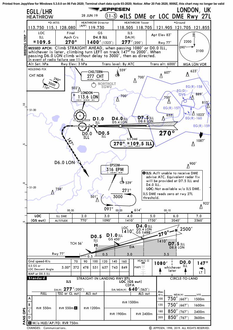
NORTHOLTEGWU
EG(R)-157
EG(R)-158
EG(R)-159
EG(R)-160
EG(D)-GVS
MISSED APCH:
LONDON, UKHEATHROW 11-3
LOC
*109.5ILL
FinalApch Crs
270^
GS
1400'(1323')
ILSDA(H)
277'(200')
STRAIGHT-IN LANDING RWY
(563')
Gnd speed-Kts 70 90 100 120 140 160
277'
MAP at D0.5 ILL
27L
D7.5
D5.4 LON
ILLD8.8 LON
D5.4 LON
D4.0 ILL
In event of radio failure see 11-6.
Climb STRAIGHT AHEAD, when passing 1080' or D0.0 ILL,
BRIE
FIN
G S
TRIP
TM
whichever is later, climbing turn LEFT on track 147^ to 2000'. Whenpassing D6.0 LON climb without delay to 3000', then as directed.
PAPI1080' D0.0
ILLlater
whichever
LT
147^
EGLL/LHR
640'
090^
180^
| JEPPESEN, 1998, 2019. ALL RIGHTS RESERVED.
JEPPESEN
ILS GS orLOC Descent Angle 3.00^
2500'
1410'DA
A
B
C
D
DA(H)
ILS LOC (GS out)
ALS out MDA(H)
CIRCLE-TO-LAND
ALS outMaxKts
135
180
205
100 (667')
(667')
3600m
2400m
1600m
1500m
(200')
1500m
FULL
1900m
750'750'850'850'
(767')
(767')
VIS
RVR
RVR
RVR 550m RVR 1200m
.Standard.
RVR 550m
DA/MDA(H)
CDFA
PA
NS O
PS
849743637531478372
Apt Elev 83'
Rwy 77'
TDZ or CL out
1
1W/o HUD/AP/FD: RVR 750m
LONDON113.6 LONLOND
EPSOM316 EPMEPM
271^
091^
3000
147^D6.0 LON
CHT NDB
51-20
51-30
00-1000-2000-30
CHILTERN277 CHTCHT
05
510
ILS DME or LOC DME Rwy 27LHEATHROW Tower *Ground
115.1*D-ATIS
128.080 118.505 118.705113.750 121.905 121.705 121.855HEATHROW Director
(APP)
922'
501'
758'
539'
900'
1087'
653' 1023'
813'750'
889'
502'
700'607' 623'559'
614'
700'
119.730
2400mRVR
28 JUN 19
Communications.
Trans level: By ATC Trans alt: 6000'
270^
D1.0 D4.0 D7.5
D0.5
CHANGES:
Alt Set: hPa
1
Rwy Elev: 3 hPa
TCH 56'GS
GS
450'
1400'1410'
0.50.5 3.0 3.5
LOC
270^D0.5 D1.0
ILLILL
D4.0 ILL
ALTITUDE
LOC(GS out)
ILL
ILLILL ILL
D8.8 LON
ILL DME 5.01730'
6.02040'
7.02360'
D0.0ILL
2.0770'
3.01090'
4.01410'
HIALS-II
ILS DME
270^ *109.5 ILL
Rwy 77'
2200
2100
290^
110^
3000
HOLDING FIX
ILS:1 Acft unable to receive DMEadvise ATC. Equivalent radar fixwill be provided at D7.5 ILL andD4.0 ILL.LOC: Not available w/o ILS DME.
ILS DME reads zero at rwy 27Lthreshold.
ILL
MSA LON VOR
Printed from JeppView for Windows 5.3.0.0 on 06 Feb 2020; Terminal chart data cycle 03-2020; Notice: After 20 Feb 2020, 0000Z, this chart may no longer be valid

NORTHOLTEGWU
EG(R)-157
EG(R)-158
EG(R)-159
EG(R)-160
EG(D)-GVS
MISSED APCH:
LONDON, UKHEATHROW
LOC
*109.5ILL
FinalApch Crs
270^
GS
1400'(1323')
1
D5.4 LON
D4.0 ILL
In event of radio failure see 11-6.
Climb STRAIGHT AHEAD, when passing 1080' or D0.0 ILL,
11-3A
27LSTRAIGHT-IN LANDING RWYCAT II ILS
RA 102'177'DA(H) (100')
BRIE
FIN
G S
TRIP
TM
whichever is later, climbing turn LEFT on track 147^ to 2000'. Whenpassing D6.0 LON climb without delay to 3000', then as directed.
PAPI1080' D0.0
ILLlater
whichever
LT
147^
EGLL/LHR
090^
180^
| JEPPESEN, 1998, 2019. ALL RIGHTS RESERVED.
JEPPESEN
CAT II/III ILS DME Rwy 27L
Refer toMinimums
.Standard.
50'
200mRVR
DH
CAT IIIA ILS
Apt Elev 83'
Rwy 77'
PA
NS O
PS
Gnd speed-KtsGS 3.00^
70 90 100 120 140 160372 478 531 637 743 849
300mRVR
CHT NDB
D5.4 LON
LONDON113.6 LONLOND
EPSOM
316 EPMEPM
271^
091^
3000
147^D6.0 LON
51-20
51-30
00-1000-2000-30
CHILTERN277 CHTCHT
05
510
HEATHROW Tower *Ground
115.1*D-ATIS
128.080 118.505 118.705113.750 121.905 121.705 121.855HEATHROW Director
(APP)
922'
501'
758'
539'
900'
1087'
653' 1023'
813'
750'889'
502'
700'607' 623'559'
614'
700'
119.730
75mRVR
CAT IIIB ILS
CAT IIIB, IIIA & II ILS
28 JUN 19
Communications.
Trans level: By ATC
CHANGES:
Alt Set: hPa Trans alt: 6000'Rwy Elev: 3 hPa
TCH 56'
GS
GS
450'
1400' 2500'
1.0 3.0 3.5
270^D1.0
D7.5
ILL
ILLD8.8 LON
D4.0 ILL
Special Aircrew & Acft Certification Required.
HIALS-II
1Acft unable to receive DMEadvise ATC. Equivalent radarfix will be provided atD7.5 ILL and D4.0 ILL.
ILS DME reads zero at rwy 27Lthreshold.
Rwy 77'
2200
2100
290^
110^
3000
HOLDING FIX
270^
D1.0 D4.0 D7.5ILL
ILL ILLD8.8 LON
D0.0ILL
ILS DME
270^ *109.5 ILLILL
MSA LON VOR
Printed from JeppView for Windows 5.3.0.0 on 06 Feb 2020; Terminal chart data cycle 03-2020; Notice: After 20 Feb 2020, 0000Z, this chart may no longer be valid

NORTHOLTEGWU
EG(R)-157
EG(R)-158
EG(R)-159EG(R)-160
EG(D)-GVS
MISSED APCH:
LONDON, UKHEATHROW 11-4
LOC
*110.3IRR
FinalApch Crs
270^
GS
1410'(1332')
ILSDA(H)
278'(200')
D4.0 IRR
STRAIGHT-IN LANDING RWY
(562')
Gnd speed-Kts 70 90 100 120 140 160
3.00^
278' 640'
MAP at D0.5 IRR
27R
D5.3 LON
D5.3 LON
Climb STRAIGHT AHEAD when passing 1580' or D0.0 IRR,whichever is later, climbing turn RIGHT on track 316^ to 3000', then as
In event of radio failure see 11-6.
1580'whichever
later
D0.0IRR
RT
316^
BRIE
FIN
G S
TRIP
TM
directed.
EGLL/LHR
PAPI
2
2
090^
180^
| JEPPESEN, 1998, 2019. ALL RIGHTS RESERVED.
JEPPESEN
ILS GS orLOC Descent Angle
2500'
DA
A
B
C
D
DA(H)
ILS LOC (GS out)
ALS out MDA(H)
CIRCLE-TO-LAND
ALS outMaxKts
135
180
205
100 (667')
(667')
3600m
2400m
1600m
1500m
(200')
1500m
FULL
2400m
750'750'850'850'
(767')
(767')
VIS
RVR
RVR
RVR 550m RVR 1200m
.Standard.
RVR 550m
DA/MDA(H)
CDFA
372 478 531 637 743 849
PA
NS O
PS
Apt Elev 83'
Rwy 78'
TDZ or CL out
1
1W/o HUD/AP/FD: RVR 750m
LONDON113.6 LON
D
316^
EPSOM316 EPM
CHILTERN277 CHT 290^
110^
EPM NDB
51-30
00-1000-2000-30
CHT
LON
EPM
05
510
ILS DME or LOC DME Rwy 27RHEATHROW Tower *Ground
115.1*D-ATIS
128.080 118.505 118.705113.750 121.905 121.705 121.855HEATHROW Director
(APP)
499'
539' 679'
900'
1087'
653'1023'
750' 889'
502'
700'607'
559'
515'
627'544'
512'978'
500'
700'
496'
119.730
1900mRVR
28 JUN 19
Communications.
270^ILS DME
D1.0
D0.5
270^ *110.3 IRR
2.0770'
3.01090'
4.01410'
LOC(GS out)
CHANGES:
Alt Set: hPa Trans level: By ATC Trans alt: 6000'Rwy Elev: 3 hPa
1
TCH 58'
0.5 0.5 2.0 3.5
LOC270^
1090'D7.5 IRRD8.8 LON
D0.5IRR
D1.0IRR450'GS
D4.0IRR
1410'GS
IRR
IRR
D4.0IRRD7.5 IRRD8.8 LON
D0.0IRR
5.01730'
6.02050'
7.02370'
IRR DME
ALTITUDE
HIALS-II
D3.0IRR
1.0
D3.0IRR
Do not descend belowthe descent profile
1.0450'
1090'
Rwy 78'
2200
2100
3000
271^
091^
3000
HOLDING FIX
IRR
MSA LON VOR
ILS:1 Acft unable to receive DMEadvise ATC. Equivalent radar fixwill be provided at D7.5 IRR andD4.0 IRR.LOC: Not available w/o ILS DME.
ILS DME reads zero at rwy 27Rthreshold.
Printed from JeppView for Windows 5.3.0.0 on 06 Feb 2020; Terminal chart data cycle 03-2020; Notice: After 20 Feb 2020, 0000Z, this chart may no longer be valid

NORTHOLTEGWU
EG(R)-157
EG(R)-158
EG(R)-159EG(R)-160
EG(D)-GVS
MISSED APCH:
LONDON, UKHEATHROW
LOC
*110.3IRR
FinalApch Crs
270^
GS
1410'(1332')
1
D4.0 IRR
D5.3 LON
Climb STRAIGHT AHEAD when passing 1580' or D0.0 IRR,whichever is later, climbing turn RIGHT on track 316^ to 3000', then as
In event of radio failure see 11-6.
PAPI1580'
whicheverlater
D0.0IRR
RT
316^
11-4A
27RCAT II ILS
STRAIGHT-IN LANDING RWY
RA 102'178'DA(H) (100')
BRIE
FIN
G S
TRIP
TM
directed.
EGLL/LHR
090^
180^
| JEPPESEN, 1998, 2019. ALL RIGHTS RESERVED.
JEPPESEN
CAT II/III ILS DME Rwy 27R
Refer toMinimums
.Standard.
50'
200mRVR
DH
CAT IIIA ILS
Apt Elev 83'
Rwy 78'
PA
NS O
PS
Gnd speed-KtsGS 3.00^
70 90 100 120 140 160372 478 531 637 743 849
300mRVR
D5.3 LON
LONDON
113.6 LOND
316^
EPSOM316 EPM
CHILTERN277 CHT 290^
110^
EPM NDB
51-30
00-1000-2000-30
CHT
EPM
LON
05
510
HEATHROW Tower *Ground
115.1*D-ATIS
128.080 118.505 118.705113.750 121.905 121.705 121.855HEATHROW Director
(APP)
499'
539' 679'
900'
1087'
653'1023'
750' 889'
502'
700'607'
559'
515'
627'544'
512'978'
500'
700'
496'
119.730
75mRVR
CAT IIIB ILS
CAT IIIB, IIIA & II ILS
28 JUN 19
Communications.
1Acft unable to receive DMEadvise ATC. Equivalent radarfix will be provided atD7.5 IRR and D4.0 IRR.
CHANGES:
Alt Set: hPa Trans level: By ATC Trans alt: 6000'Rwy Elev: 3 hPa
TCH 58'
1.0 3.0 3.5
270^2500'
D7.5 IRRD8.8 LON
D1.0 IRR450'GS
D4.0 IRR
1410'GS
Special Aircrew & Acft Certification Required.
HIALS-II
ILS DME reads zero at rwy 27Rthreshold.
Rwy 78'
2200
2100
270^ILS DME
D1.0
270^ *110.3 IRR
IRR
D4.0 IRRD7.5 IRRD8.8 LON
D0.0IRR
D3.0IRR
3000
271^
091^
3000
HOLDING FIX
IRR
MSA LON VOR
Printed from JeppView for Windows 5.3.0.0 on 06 Feb 2020; Terminal chart data cycle 03-2020; Notice: After 20 Feb 2020, 0000Z, this chart may no longer be valid

267^
FARNBOROUGHEGLF
FAIROAKSEGTF
NORTHOLTEGWU
EGLK
BLACKBUSHE
EG(D)-132
EG(R)-160
EG(D)-133A
EG(D)-GVS
EG(D)-133
EG(R)-158
EG(R)-157
MISSED APCH:
MISSED APCH:
Apt Elev
05
510
1520
037^
D12.0OCK
EPM NDB at 3000', thence:
In event of radio failure, on passing D10.0 LON proceed toCHT NDB at 3000', thence:
EGLL/LHR
OCKHAM115.3 OCK
D
090^
GWCD39.0
(R- 001 GW
C)
181^
O C KGOODWOOD114.75 GWC
DG W C
D10.0IBB
IBBD7.5
IAAD7.5
LAMBOURNE115.6 LAM
DL A M
In event of radio failure, on passing D10.0 LON turn RIGHT to
JEPPESEN
| JEPPESEN, 1998, 2018. ALL RIGHTS RESERVED.
PA
NS O
PS
D34.0 LAM
IAAD10.0
5 OCT 18
290^110^
Holding bearings.
3000
271^
091^
3000
489'
499'
1014'486'484'
922'
501'
758'766'
568'
539' 679'765'
900'
513'
519' 1087'505'
485'
653'1023'
750' 889'545'
528'528'
700'607'559'
627'722'
544'
512'770' 978'992'
932'846'
793'
1184'554'
728'932' 512'728'
810' 920'
614'
692'
700'
740'
277 CHTCHILTERN
090^
VIA CHILTERN NDB
C H T
267^
3000
51-20
51-30
51-40
00-50
VIA EPSOM NDB
CHANGES:
HEATHROW83' 11-5
RWY 09L/RPROCEDURES TO BE USED IN THE EVENT OF RADIO
FAILURE FOLLOWING A MISSED APPROACH
LONDON, UK
D10.0LON
D113.6 LONLONDON
283^14.3
3000
L O N
D10.0
00-40 00-30 00-20 00-10
LON
MAX 180 KT
3000'At
2500'At
316 EPMEPSOM
E P M
Rwy 09L: After holding leave EPM NDB on track 283^ maintaining 3000'. At D12.0 OCK (MAX 180 KT) turn RIGHT to intercept ILS localizer courseto be established at D10.0 IAA. After D10.0 IAA descend to 2500'.Continue approach as charted for rwy 09L.
Rwy 09L: After holding leave CHT NDB on R-267 LAM maintaining 3000'. AtD34.0 LAM turn LEFT to 181^ (R-001 GWC). At D39.0 GWC turn LEFT tointercept ILS localizer course to be established at D10.0 IAA. AfterD10.0 IAA descend to 2500'. Continue approach as charted for rwy 09L.
Rwy 09R: After holding leave CHT NDB on R-267 LAM maintaining 3000'. AtD34.0 LAM turn LEFT to 181^ (R-001 GWC). At D39.0 GWC turn LEFT tointercept ILS localizer course to be established at D10.0 IBB. AfterD10.0 IBB descend to 2500'. Continue approach as charted for rwy 09R.
I A AILS DME 09L
090^ *110.3 IAA
ILS DME 09R
I B B090^ *109.5 IBB
Rwy 09R: After holding leave EPM NDB on track 283^ maintaining 3000'. At D12.0 OCK (MAX 180 KT) turn RIGHT to intercept ILS localizer courseto be established at D10.0 IBB. After D10.0 IBB descend to 2500'.Continue approach as charted for rwy 09R.
Holdings, initial and intermediate approach valid up to 220 KT.
3000'At
3000'At
090^
Printed from JeppView for Windows 5.3.0.0 on 06 Feb 2020; Terminal chart data cycle 03-2020; Notice: After 20 Feb 2020, 0000Z, this chart may no longer be valid

BIGGIN HILLEGKB
FARNBOROUGHEGLF
FAIROAKSEGTF
063^
NORTHOLTEGWU
EG(D)-132 EG(D)-133A
EG(R)-159EG(R)-160
EG(R)-157
EG(R)-158
EG(D)-GVS
EG(D)-133
LONDON
EGLC
London City
MISSED APCH:
MISSED APCH: In event of radio failure, on reaching 3000' proceed toEPM NDB at 3000', thence:
317^
CHT NDB at 3000', thence:
BOVINGDON113.75 BNN
D
Apt ElevEGLL/LHR
D19.0BNN
D12.0OCK
IRRD7.5
ILLD7.5
ILLD10.0
B N N
OCKHAM115.3 OCK
DO C K
In event of radio failure, on passing D10.0 LON turn RIGHT to
JEPPESEN
| JEPPESEN, 1998, 2018. ALL RIGHTS RESERVED.
PA
NS O
PS
D10.0 IRR
5 OCT 18
Bearings.
271^
091^
3000
110^
110^
3000
15.13000
499'
1014'
922'
1050'501'
718'
758'766' 652'
539' 679'765' 544' 900'
513'
505'1087'
853'600'
568'653'
813'1015'750'
545' 502' 555'
528'542'
700'
559'
515'
627'544'644' 742'512'
770'
978'932' 500'
846' 742'793' 554'
604'
728'932' 512'810' 920'
614'
524'
740'
270^270^
51-20
51-30
00-50 00-00
CHANGES:
HEATHROW
RWY 27L/RPROCEDURES TO BE USED IN THE EVENT OF RADIO
LONDON, UK
VIA CHILTERN NDB
VIA EPSOM NDB
05
510
D113.6 LONLONDON
L O N
277 CHTCHILTERN
C H T51-40
FAILURE FOLLOWING A MISSED APPROACH15
20
LOND10.0
11-683'
074^9.0
3000
00-40 00-30 00-20 00-10
316 EPMEPSOM
E P M3000'At
2500'At
MAX 180 KT
359^
I R R270^ *110.3 IRRILS DME 27R
I L L270^ *109.5 ILLILS DME 27L
Rwy 27L: After holding leave EPM NDB on R-074 OCK maintaining 3000'. At D12.0 OCK turn LEFT onto track 359^. At R-063 OCK turn LEFT to intercept ILS localizer to be established at D10.0 ILL. After D10.0 ILLdescend to 2500'. Continue approach as charted for rwy 27L.
Rwy 27R: After holding leave EPM NDB on R-074 OCK maintaining 3000'. At D12.0 OCK turn LEFT onto track 359^. At R-063 OCK turn LEFT to intercept ILS localizer to be established at D10.0 IRR. After D10.0 IRRdescend to 2500'. Continue approach as charted for rwy 27R.
Rwy 27L: After holding leave CHT NDB on track 110^ maintaining 3000'. At D19.0 BNN (MAX 180 KT) turn RIGHT to intercept ILS localizer to beestablished at D10.0 ILL. After D10.0 ILL descend to 2500'. Continueapproach as charted for rwy 27L.
Rwy 27R: After holding leave CHT NDB on track 110^ maintaining 3000'. At D19.0 BNN (MAX 180 KT) turn RIGHT to intercept ILS localizer to beestablished at D10.0 IRR. After D10.0 IRR descend to 2500'. Continueapproach as charted for rwy 27R.
Holdings, initial and intermediate approach valid up to 220 KT.
3000'At
Printed from JeppView for Windows 5.3.0.0 on 06 Feb 2020; Terminal chart data cycle 03-2020; Notice: After 20 Feb 2020, 0000Z, this chart may no longer be valid

NORTHOLTEGWU
EG(R)-160
090^037^
ABAVI(IF) RW~9L
LONDON113.6 LON
D
CHILTERN277 CHT
L O N
EPSOM316 EPMEPM
PAPI
HIALS-II
L~9LTRW~9LABAVI
3000'
05
510
HEATHROWLONDON, UKEGLL/LHR
RNAV
FinalApch Crs
090^L~9LT
2500'(2421')
Apt Elev
Rwy
83'
79'
Alt Set: hPa Rwy Elev: 3 hPa Trans level: By ATC Trans alt: 6000'MSA ARP
MISSED APCH:
BRIE
FIN
G S
TRIP
TM
In event of radio failure see 11-5.
LNAV/VNAV
EPM NDB
JEPPESEN
3.20^
C H T290^
110^
51-30
00-2000-3000-40
00-50
51-35
51-25
2170' 1830' 1490' 1150' 810'
The missed apch revertsto conventional navigationafter passing 1580'.
Climb to 3000'. STRAIGHT AHEAD until passing 1580'or D0.0 IAA inbound, whichever is later, then turn LEFT onto 037^and as directed.
RNAV (GNSS) Y Rwy 09L
1. Pilots should request RNAV Y approach on first contact with Director. 2. Acft will normally be radarvectored from holding/IAF. 3. ILS DME reads zero at rwy 09L thresh. 4. Minimum temperature -10^C.
TCH 50'
L~9LT
LNAV/VNAV: MAP at DALNAV: MAP at RW~9L/D0.0 IAA
ALS out MDA(H)
STRAIGHT-IN LANDING RWY CIRCLE-TO-LAND09L
VIS
A
B
C
D
MaxKts100
135
180
2051500mRVR
670'(587') 1500m
720'(637') 1600m
(737') 2400m
(747') 3600m
820'830'
620'(541')
LNAV/VNAV LNAV
ALS out
2200mRVR
.Standard.
CDFADA/MDA(H)
2400mRVR
Gnd speed-KtsDescent Angle 3.20^
70 90 100 120 140 160396 510 566 679 793 906
DA(H) 450'(371')540'(461')D:470'(391')C:A:
B:460'(381')
RVR 1100mRVR 1800m
Refer toMinimums
12-01
MDA
5. PAPI angle is 3.00^.
2300
Procedure Alt
RVR 1800m
RVR 1500mRVR 1500mRVR 1000m
28 JUN 19
| JEPPESEN, 2017, 2019. ALL RIGHTS RESERVED.
HEATHROW Tower *Ground
115.1*D-ATIS
128.080 118.505 118.705113.750 121.905 121.705 121.855HEATHROW Director
(APP)
Communications.
545'
502'528'
700'
559'
515'
544'
644' 512'
770'
978'
700'
499'932'
119.730
DA(H)
D0.0 IAA
79'
3000'
ALTITUDE
DIST to RW~9L
090^
3.0
CHANGES:
2500'
271^
091^
3000
D0.0 IAA
7.010.0 0
PA
NS O
PS
3000
ILS DME
I A A*110.3 IAA
6.0 5.0 4.0 3.0 2.0
HOLDING FIX
7.0 Rwy
800'
Printed from JeppView for Windows 5.3.0.0 on 06 Feb 2020; Terminal chart data cycle 03-2020; Notice: After 20 Feb 2020, 0000Z, this chart may no longer be valid

NORTHOLTEGWU
EG(R)-160
090^037^
ABAVI(IF) RW~9L
L~9LF
LONDON113.6 LON
D
CHILTERN277 CHT
L O N
EPSOM316 EPMEPM
PAPI
HIALS-II
L~9LFRW~9LABAVI
3000'
05
510
HEATHROWLONDON, UKEGLL/LHR
RNAV
FinalApch Crs
090^
Minimum AltL~9LF
2500'(2421')
DA(H)
570'(491')
Apt Elev
Rwy
83'
79'
Alt Set: hPa Rwy Elev: 3 hPa Trans level: By ATC Trans alt: 6000'
12-1
MSA ARP
MISSED APCH:
BRIE
FIN
G S
TRIP
TM
Gnd speed-Kts 70 90 100 120 140 160
In event of radio failure see 11-5.
Descent Angle 372 478 531 637 743 849
LNAV/VNAV
EPM NDB
JEPPESEN
3.00^
3.00^
C H T290^
110^
51-30
00-2000-3000-40
00-50
51-35
51-25
2360' 2040' 1730' 1410' 1090' 770'
The missed apch revertsto conventional navigationafter passing 1580'.
Climb to 3000'. STRAIGHT AHEAD until passing 1580'or D0.0 IAA inbound, whichever is later, then turn LEFT onto 037^and as directed.
RNAV (GNSS) Z Rwy 09L
1. Pilots should request RNAV Z approach on first contact with Director. 2. Acft will normally be radarvectored from holding/IAF. 3. ILS DME reads zero at rwy 09L thresh. 4. Minimum temperature -10^C.
TCH 50'
| JEPPESEN, 2012, 2019. ALL RIGHTS RESERVED.
28 JUN 19
HEATHROW Tower *Ground
115.1
*D-ATIS
128.080 118.505 118.705113.750 121.905 121.705 121.855
HEATHROW Director(APP)
2300
MDA
545'
528'
700'
559'
515'
544'
644' 512'
770'
978'
700'
499'932'
119.730
502'
LNAV: MAP at RW~9L/D0.0 IAALNAV/VNAV: MAP at DA
Communications.
ALS out MDA(H)
STRAIGHT-IN LANDING RWY CIRCLE-TO-LAND09L
VIS
1500m
DA(H) 570'(491')
A
B
C
D
MaxKts100
135
180
2051500mRVR
750'(667') 1500m
750'(667') 1600m
(767') 2400m
(767') 3600m
850'
850'
630'(551')
LNAV/VNAV LNAV
ALS out
2300mRVR
RVR
.Standard.
CDFADA/MDA(H)
1500mRVR
1800mRVR 2400mRVR
D0.0 IAA
79'
3000'
ALTITUDE
DIST to RW~9L
090^
2.6
CHANGES:
2500'
271^
091^
3000
D0.0 IAA
7.410.0 0
PA
NS O
PS
3000
ILS DME
I A A*110.3 IAA
7.0 6.0 5.0 4.0 3.0 2.0
HOLDING FIX
7.4 Rwy
Printed from JeppView for Windows 5.3.0.0 on 06 Feb 2020; Terminal chart data cycle 03-2020; Notice: After 20 Feb 2020, 0000Z, this chart may no longer be valid

EG(D)-132
EG(D)-133B
EG(D)-133A
EG(R)-160
EG(R)-157
090^
090^BENPA(IF)
RW~9RL~9RT
LONDON113.6 LON
DCHILTERN
277 CHT L O N
EPSOM316 EPMEPM
CHT NDB
C H T
271^
091^
ILS DME
I B B*109.5 IBB
PAPI
HIALS-II
L~9RT RW~9RBENPA
STRAIGHT-IN LANDING RWY CIRCLE-TO-LAND09R
3000'
05
510
HEATHROWLONDON, UKEGLL/LHR
RNAV
FinalApch Crs
090^L~9RT
2500'(2425')
Apt Elev
Rwy
83'
75'
Alt Set: hPa Rwy Elev: 3 hPa Trans level: By ATC Trans alt: 6000'MSA ARP
MISSED APCH:
BRIE
FIN
G S
TRIP
TM
In event of radio failure see 11-5.
LNAV/VNAV
JEPPESEN
3.20^
.Standard.
51-20
51-30
00-3000-40
Climb STRAIGHT AHEAD to 3000' and as directed.
The missed apch revertsto conventional navigationafter passing 3000'.
RNAV (GNSS) Y Rwy 09R
TCH 50'
MDA
12-02
2160' 1820' 1480' 1140' 800'
LNAV/VNAV: MAP at DA
Gnd speed-KtsDescent Angle 3.20^
70 90 100 120 140 160396 510 566 679 793 906
ALS out MDA(H) VIS
A
B
C
D
MaxKts100
135
180
205
670'(587') 1500m
720'(637') 1600m
(737') 2400m
(747') 3600m
820'830'
620'(545')
LNAV/VNAV LNAV
ALS out
CDFADA/MDA(H)
DA(H) 400'(325')540'(465')D:430'(355')C:A:
B:410'(335')
RVR 800m
RVR 1600mRVR 900m
Refer toMinimums
1. Pilots should request RNAV Y approach on first contact with Director. 2. Acft will normally be radarvectored from holding/IAF. 3. ILS DME reads zero at rwy 09R thresh. 4. Minimum temperature -10^C. 5. PAPI angle is 3.00^.
2300
LNAV: MAP at RW~9R
RVR 1500m RVR 2200m
Procedure Alt
RVR 1500m
RVR 2400mRVR 1800m
RVR 1500m
28 JUN 19
| JEPPESEN, 2017, 2019. ALL RIGHTS RESERVED.
HEATHROW Tower *Ground
115.1*D-ATIS
128.080 118.505 118.705113.750 121.905 121.705 121.855HEATHROW Director
(APP)
Communications.
501'
758'766'
539' 679'765'
513'
505'
545'
502'528'700'
119.730
DA(H)
290^
110^
3000
3000
75'
3000' 090^
3.0
CHANGES:
2500'
7.010.0 0
PA
NS O
PS
HOLDING FIX
7.0 Rwy
ALTITUDE
DIST to RW~9R 6.0 5.0 4.0 3.0 2.0
800'
Printed from JeppView for Windows 5.3.0.0 on 06 Feb 2020; Terminal chart data cycle 03-2020; Notice: After 20 Feb 2020, 0000Z, this chart may no longer be valid
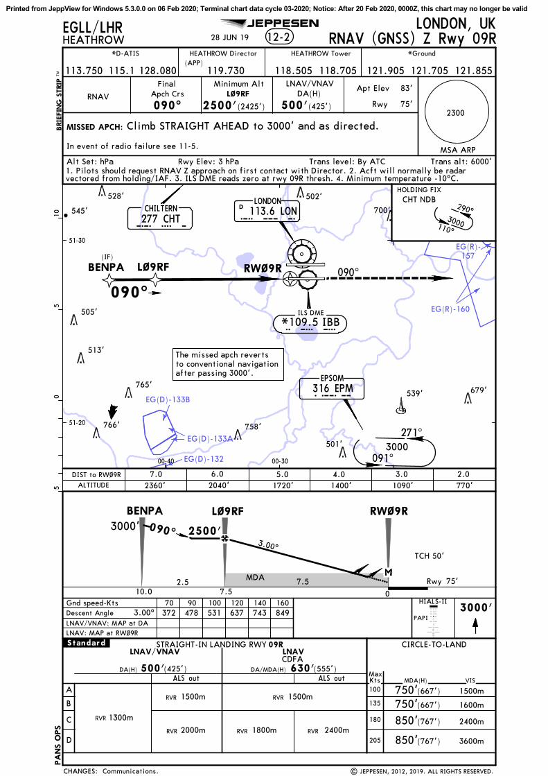
EG(D)-132
EG(D)-133B
EG(D)-133A
EG(R)-160
EG(R)-157
090^
090^BENPA(IF)
RW~9RL~9RF
LONDON113.6 LON
DCHILTERN
277 CHT L O N
EPSOM316 EPMEPM
CHT NDB
C H T
271^
091^
ILS DME
I B B*109.5 IBB
2360' 2040' 1720' 1400' 1090' 770'
PAPI
HIALS-II
L~9RF RW~9RBENPA
ALS out MDA(H)
STRAIGHT-IN LANDING RWY CIRCLE-TO-LAND09R
VIS
1500m
DA(H) 500'(425')
3000'
A
B
C
D
MaxKts100
135
180
205
1300mRVR
750'(667') 1500m
750'(667') 1600m
(767') 2400m
(767') 3600m
05
510
HEATHROWLONDON, UKEGLL/LHR
RNAV
FinalApch Crs
090^
Minimum AltL~9RF
2500'(2425')
DA(H)
500'(425')
Apt Elev
Rwy
83'
75'
Alt Set: hPa Rwy Elev: 3 hPa Trans level: By ATC Trans alt: 6000'
12-2
MSA ARP
MISSED APCH:BRIE
FIN
G S
TRIP
TM
Gnd speed-Kts 70 90 100 120 140 160
In event of radio failure see 11-5.
Descent Angle 372 478 531 637 743 849
850'
850'
LNAV/VNAV
630'(555')
LNAV/VNAV LNAV
ALS out
2000mRVR
RVR
JEPPESEN
3.00^
3.00^
.Standard.
CDFADA/MDA(H)
1500mRVR
1800mRVR 2400mRVR
51-20
51-30
00-3000-40
Climb STRAIGHT AHEAD to 3000' and as directed.
The missed apch revertsto conventional navigationafter passing 3000'.
RNAV (GNSS) Z Rwy 09R
TCH 50'
1. Pilots should request RNAV Z approach on first contact with Director. 2. Acft will normally be radarvectored from holding/IAF. 3. ILS DME reads zero at rwy 09R thresh. 4. Minimum temperature -10^C.
| JEPPESEN, 2012, 2019. ALL RIGHTS RESERVED.
MDA
28 JUN 19
HEATHROW Tower *Ground
115.1
*D-ATIS
128.080 118.505 118.705113.750 121.905 121.705 121.855
HEATHROW Director(APP)
2300
501'
758'766'
539' 679'765'
513'
505'
545'
502'528'
119.730
700'
LNAV: MAP at RW~9RLNAV/VNAV: MAP at DA
Communications.
290^
110^
3000
3000
75'
3000'
ALTITUDE
7.0 6.0 5.0 4.0 3.0 2.0DIST to RW~9R
090^
2.5
CHANGES:
2500'
7.510.0 0
PA
NS O
PS
HOLDING FIX
7.5 Rwy
Printed from JeppView for Windows 5.3.0.0 on 06 Feb 2020; Terminal chart data cycle 03-2020; Notice: After 20 Feb 2020, 0000Z, this chart may no longer be valid

EG(D)-133AEG(D)-133B
EG(R)-160
EG(D)-GVS
EG(R)-158EG(R)-
157
PAPI
HIALS-II
L27LTRW27L NEKSA
STRAIGHT-IN LANDING RWY CIRCLE-TO-LAND27L
2000'
CHILTERN277 CHTLONDON
113.6 LOND
EPSOM316 EPM
270^
148^
NEKSA(IF)
RW27L L27LT
L O N
E P M
271^
091^
D6.0 LON
3000
51-20
51-30
00-1000-2000-30
05
510
HEATHROWLONDON, UKEGLL/LHR
RNAV
FinalApch Crs
270^L27LT
2500'(2423')
Apt Elev
Rwy
83'
77'
Alt Set: hPa Rwy Elev: 3 hPa Trans level: By ATC Trans alt: 6000'MSA ARP
MISSED APCH:
BRIE
FIN
G S
TRIP
TM
In event of radio failure see 11-6.
C H T
CHT NDB
JEPPESEN
TCH 50'3.20^
.Standard.
Climb to 2000'. STRAIGHT AHEAD until passing 1080'or D0.0 ILL inbound, whichever is later, then turn LEFT onto 148^.
directed.When passing D6.0 LON climb to 3000' without delay and as
The missed apch revertsto conventional navigationafter passing 1080'.
RNAV (GNSS) Y Rwy 27L12-03
LNAV/VNAV: MAP at DALNAV: MAP at RW27L/D0.0 ILL
Gnd speed-KtsDescent Angle 3.20^
70 90 100 120 140 160396 510 566 679 793 906
ALS out MDA(H) VIS
A
B
C
D
MaxKts100
135
180
205
670'(587') 1500m
720'(637') 1600m
(737') 2400m
(747') 3600m
820'830'
640'(563')
LNAV/VNAV LNAV
ALS out
CDFADA/MDA(H)
1900mRVR 2400mRVR
DA(H) 380'(303')440'(363')D:400'(323')C:A:
B:390'(313')
1400mRVR
RVR 1500mRVR 800m
With TDZ & CL & HUD: RVR 700m1
RVR 750m1
2170'1830'1490'1150'810'
MDA
LNAV/VNAV
Refer toMinimums
1. Pilots should request RNAV Y approach on first contact with Director. 2. Acft will normally be radarvectored from holding/IAF . 3. Pilots should not expect descent clearance below 4000' until 13 NM fromtouchdown. 4. ILS DME reads zero at rwy 27L threshold. 5. Minimum temperature -10^C. 6. PAPI angleis 3.00^.
Procedure Alt
RVR 1500m
2300
| JEPPESEN, 2017, 2019. ALL RIGHTS RESERVED.
RVR 1000m RVR 1700m
28 JUN 19
HEATHROW Tower *Ground
115.1*D-ATIS
128.080 118.505 118.705113.750 121.905 121.705 121.855HEATHROW Director
(APP)
Communications.
922'
501'
539'679'
900'
1087'
653'1023'
750'
614'
700' 889'
119.730
DA(H)
77'
3000'270^
3.0
CHANGES:
2500'
290^
110^
3000
D0.0 ILL
D0.0 ILL
ILS DME
I L L*109.5 ILL
7.0 10.00
PA
NS O
PS
HOLDING FIX
7.0Rwy
ALTITUDE
DIST to RW27L 6.05.04.03.02.0
900'
Printed from JeppView for Windows 5.3.0.0 on 06 Feb 2020; Terminal chart data cycle 03-2020; Notice: After 20 Feb 2020, 0000Z, this chart may no longer be valid

EG(D)-133AEG(D)-133B
EG(R)-160
EG(D)-GVS
EG(R)-158EG(R)-
157
2360'2040'1720'1410'
PAPI
1090'
HIALS-II
L27LFRW27L
770'
NEKSA
ALS out MDA(H)
STRAIGHT-IN LANDING RWY CIRCLE-TO-LAND27L
VIS
1500m
DA(H) 510'(433')
2000'
A
B
C
D
MaxKts100
135
180
205
1300mRVR
750'(667') 1500m
750'(667') 1600m
(767') 2400m
(767') 3600m
CHILTERN277 CHTLONDON
113.6 LOND
EPSOM316 EPM
270^
NEKSA(IF)
RW27L L27LF
D6.0 LON
05
510
HEATHROWLONDON, UKEGLL/LHR
RNAV
FinalApch Crs
270^
Minimum AltL27LF
2500'(2423')
DA(H)
510'(433')
Apt Elev
Rwy
83'
77'
Alt Set: hPa Rwy Elev: 3 hPa Trans level: By ATC Trans alt: 6000'
12-3
MSA ARP
MISSED APCH:
BRIE
FIN
G S
TRIP
TM
Gnd speed-Kts 70 90 100 120 140 160
In event of radio failure see 11-6.
Descent Angle 372 478 531 637 743 849
850'
850'
LNAV/VNAV
640'(563')
LNAV/VNAV LNAV
ALS out
2000mRVR
RVR
CHT NDB
270^
| JEPPESEN, 2007, 2019. ALL RIGHTS RESERVED.
JEPPESEN
TCH 50'3.00^
3.00^
.Standard.
CDFADA/MDA(H)
1500mRVR
1900mRVR 2400mRVR
Climb to 2000'. STRAIGHT AHEAD until passing 1080'or D0.0 ILL inbound, whichever is later, then turn LEFT onto 147^.
directed.When passing D6.0 LON climb to 3000' without delay and as
The missed apch revertsto conventional navigationafter passing 1080'.
RNAV (GNSS) Z Rwy 27L
1. Pilots should request RNAV Z approach on first contact with Director. 2. Acft will normally be radarvectored from holding/IAF . 3. Pilots should not expect descent clearance below 4000' until 13 NM fromtouchdown. 4. ILS DME reads zero at rwy 27L threshold. 5. Minimum temperature -10^C.
2300
LNAV/VNAV: MAP at DA
LNAV: MAP at RW27L/D0.0 ILL
51-20
51-30
00-1000-2000-30
EPM
CHTLON
MDA
271^
091^
290^
110^
3000
3000
270^
147^
28 JUN 19
HEATHROW Tower *Ground
115.1
*D-ATIS
128.080 118.505 118.705113.750 121.905 121.705 121.855
HEATHROW Director(APP)
922'
501'
539'
679'
900'
1087'
653'1023'
750'
614'
700' 889'
119.730
Communications.
77'
3000'
ALTITUDE
7.06.05.04.03.02.0DIST to RW27L
2.5
CHANGES:
2500'
D0.0 ILL
D0.0 ILL
ILS DME
I L L*109.5 ILL
7.5 10.00
PA
NS O
PS
HOLDING FIX
7.5Rwy
Printed from JeppView for Windows 5.3.0.0 on 06 Feb 2020; Terminal chart data cycle 03-2020; Notice: After 20 Feb 2020, 0000Z, this chart may no longer be valid

NORTHOLTEGWU
EG(R)-157
EG(R)-158
EG(R)-160
EG(D)-GVS
CHILTERN277 CHT
LONDON113.6 LON
D
EPSOM316 EPM
270^
317^RW27R L27RT
L O N
E P M
C H T
EPM NDB
290^
110^
05
510
HEATHROWLONDON, UKEGLL/LHR
RNAV
FinalApch Crs
270^L27RT
2500'(2422')
Apt Elev
Rwy
83'
78'
Alt Set: hPa Rwy Elev: 3 hPa Trans level: By ATC Trans alt: 6000'
MSA ARP
MISSED APCH:
BRIE
FIN
G S
TRIP
TM
In event of radio failure see 11-6.
LNAV/VNAV
JEPPESEN
51-30
51-35
PAPI
HIALS-II
L27RTRW27R IVLAR
STRAIGHT-IN LANDING RWY CIRCLE-TO-LAND27R
3000'
TCH 50'3.20^
.Standard.
00-10
00-2000-30
51-25
and as directed.
The missed apch revertsto conventional navigationafter passing 1580'.
Climb to 3000'. STRAIGHT AHEAD until passing 1580'or D0.0 IRR inbound, whichever is later, then turn RIGHT onto 317^
RNAV (GNSS) Y Rwy 27R12-04
ALS out MDA(H) VIS
A
B
C
D
MaxKts100
135
180
205
670'(587') 1500m
720'(637') 1600m
(737') 2400m
(747') 3600m
820'830'
640'(562')
LNAV/VNAV LNAV
ALS out
CDFADA/MDA(H)
1900mRVR
DA(H) 380'(302')440'(362')D:400'(322')C:A:
B:390'(312')
1400mRVR
RVR 1500m
RVR 750m1
LNAV/VNAV: MAP at DALNAV: MAP at RW27R/D0.0 IRR
Gnd speed-KtsDescent Angle 3.20^
70 90 100 120 140 160396 510 566 679 793 906
2170'1830'1490'1150'810'
MDA
1With TDZ & CL & HUD: RVR 700m
DA(H)Refer to
Minimums
1. Pilots should request RNAV Y approach on first contact with Director. 2. Acft will normally be radarvectored from holding/IAF . 3. Pilots should not expect descent clearance below 4000' until 13 NM fromtouchdown. 4. ILS DME reads zero at rwy 27R threshold. 5. Minimum temperature -10^C. 6. PAPI angleis 3.00^.
2300
Procedure Alt
RVR 800m
RVR 1500m
RVR 1000m RVR 1700m
| JEPPESEN, 2017, 2019. ALL RIGHTS RESERVED.
28 JUN 19
RVR 2400m
HEATHROW Tower *Ground
115.1*D-ATIS
128.080 118.505 118.705113.750 121.905 121.705 121.855HEATHROW Director
(APP)
Communications.
853'
653'1023'
750'889'
502'
700'607'
559'
515'
627'544'
512' 978'
119.730
(IF)
IVLAR
271^
091^
3000
D0.0 IRR
3000
ILS DME
I R R*110.3 IRR
D0.0 IRR
78'
3000'270^
3.0
CHANGES:
2500'
7.0 10.00
PA
NS O
PS
HOLDING FIX
7.0Rwy
ALTITUDE
DIST to RW27R 6.05.04.03.02.0
900'
Printed from JeppView for Windows 5.3.0.0 on 06 Feb 2020; Terminal chart data cycle 03-2020; Notice: After 20 Feb 2020, 0000Z, this chart may no longer be valid
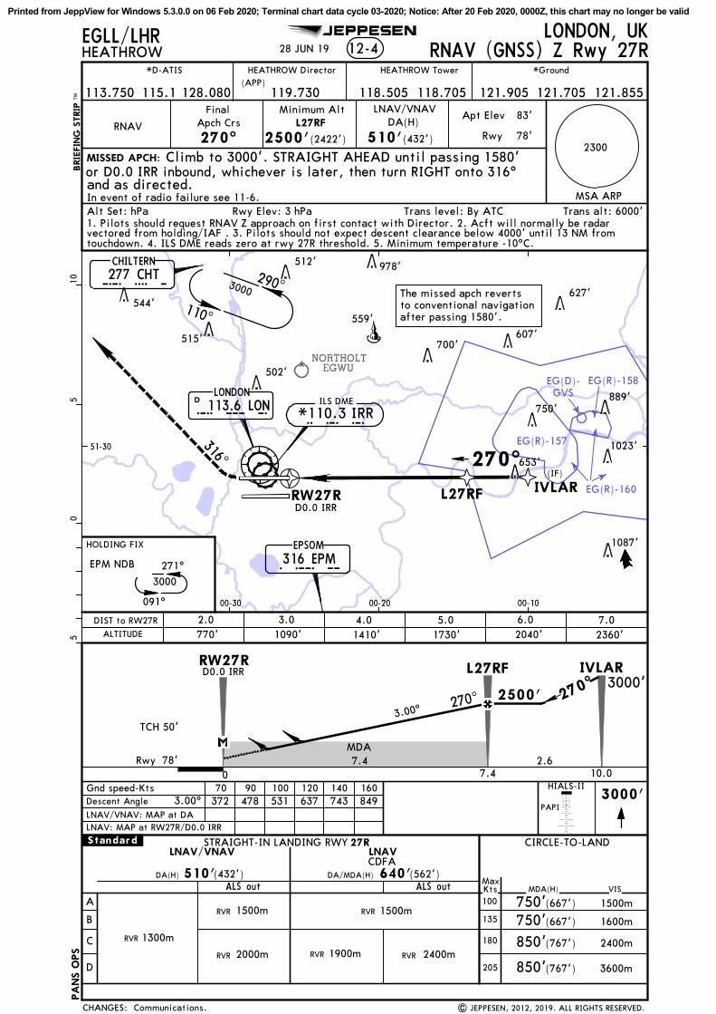
NORTHOLTEGWU
EG(R)-157
EG(R)-158
EG(R)-160
EG(D)-GVS
CHILTERN277 CHT
LONDON113.6 LON
D
EPSOM316 EPM
270^(IF)
RW27R L27RF
L O N
E P M
C H T
EPM NDB
05
510
HEATHROWLONDON, UKEGLL/LHR
RNAV
FinalApch Crs
270^
Minimum AltL27RF
2500'(2422')
DA(H)
510'(432')
Apt Elev
Rwy
83'
78'
Alt Set: hPa Rwy Elev: 3 hPa Trans level: By ATC Trans alt: 6000'
12-4
MSA ARP
MISSED APCH:
BRIE
FIN
G S
TRIP
TM
In event of radio failure see 11-6.
LNAV/VNAV
JEPPESEN
270^
2360'2040'1730'1410'
PAPI
1090'
HIALS-II
L27RFRW27R
770'
IVLAR
ALS out MDA(H)
STRAIGHT-IN LANDING RWY CIRCLE-TO-LAND27R
VIS
1500m
DA(H) 510'(432')
3000'
A
B
C
D
MaxKts100
135
180
205
1300mRVR
750'(667') 1500m
750'(667') 1600m
(767') 2400m
(767') 3600m
Gnd speed-Kts 70 90 100 120 140 160Descent Angle 372 478 531 637 743 849
850'
850'
640'(562')
LNAV/VNAV LNAV
ALS out
2000mRVR
RVR
TCH 50'3.00^
3.00^
.Standard.
CDFADA/MDA(H)
1900mRVR 2400mRVR
and as directed.
The missed apch revertsto conventional navigationafter passing 1580'.
Climb to 3000'. STRAIGHT AHEAD until passing 1580'or D0.0 IRR inbound, whichever is later, then turn RIGHT onto 316^
RNAV (GNSS) Z Rwy 27R
1. Pilots should request RNAV Z approach on first contact with Director. 2. Acft will normally be radarvectored from holding/IAF . 3. Pilots should not expect descent clearance below 4000' until 13 NM fromtouchdown. 4. ILS DME reads zero at rwy 27R threshold. 5. Minimum temperature -10^C.
| JEPPESEN, 2012, 2019. ALL RIGHTS RESERVED.
IVLAR
2300
LNAV: MAP at RW27R/D0.0 IRRLNAV/VNAV: MAP at DA
51-30
00-1000-2000-30
1500mRVR
MDA
290^
110^
270^
3000
091^
271^
3000
316^
28 JUN 19
HEATHROW Tower *Ground
115.1
*D-ATIS
128.080 118.505 118.705113.750 121.905 121.705 121.855
HEATHROW Director(APP)
Communications.
653'
1023'
750'889'
502'
700'607'
559'
515'
627'544'
512' 978'
119.730
1087'
D0.0 IRR
ILS DME
I R R*110.3 IRR
D0.0 IRR
78'
3000'
ALTITUDE
7.06.05.04.03.02.0DIST to RW27R
2.6
CHANGES:
2500'
7.4 10.00
PA
NS O
PS
HOLDING FIX
7.4Rwy
Printed from JeppView for Windows 5.3.0.0 on 06 Feb 2020; Terminal chart data cycle 03-2020; Notice: After 20 Feb 2020, 0000Z, this chart may no longer be valid

Chart changes since cycle 02-2020
ADD = added chart, REV = revised chart, DEL = deleted chart.ACT PROCEDURE IDENT INDEX REV DATE EFF DATE
LONDON, (HEATHROW - EGLL)REV AIRPORT BRIEFING (GEN CON... 10-1P2 07 Feb 2020REV AIRPORT BRIEFING (ARR) 10-1P3 07 Feb 2020
Chart changes since cycle 02-2020
ADD = added chart, REV = revised chart, DEL = deleted chart.ACT PROCEDURE IDENT INDEX REV DATE EFF DATE
LONDON, (HEATHROW - EGLL)REV AIRPORT BRIEFING (GEN CON... 10-1P2 07 Feb 2020REV AIRPORT BRIEFING (ARR) 10-1P3 07 Feb 2020
Revision Letter For Cycle 03-2020Printed on 06 Feb 2020Page 1(c) JEPPESEN SANDERSON, INC., 2020, ALL RIGHTS RESERVED
jep=JEPPESEN
JeppView for Windows

TERMINAL CHART CHANGE NOTICES
Chart Change Notices for Airport EGLL
Type: TerminalEffectivity: TemporaryBegin Date: 20191010End Date: 20201007
Trial RNAV APCHs for RWYs 09L, 09R, 27L and 27R available (based on SUP 40-19, 29 Aug 19). Pilots wishing to take part in the trial should "Request RNAV Yankee" on first contact with HEATHROW Director 119.730. Refer to temporary charts 12-01 thru 12-04. In the event that the required navigation equipment fails, the flight crew shall advise ATC that they can no longer continue with the procedure or are unable to accept the procedure using the phraseology: "(Callsign), unable RNAV due equipment". For further assistance email [email protected] and [email protected].
Type: TerminalEffectivity: TemporaryBegin Date: ImmediatelyEnd Date: Until Further Notice
All non 8.33 KHz equipped acft should contact ATC on published number to obtain ATC clearance and weather information.
Type: TerminalEffectivity: TemporaryBegin Date: 20190719End Date: Until Further Notice
(10-8) Taxiway restrictions (based on SUP 048/2019) due to rehabilitation works on grass areas. Refer to temp chart 10-8 and latest NOTAMS.
Chart Change Notices for Country GBR
Type: Gen TmnlEffectivity: PermanentBegin Date: ImmediatelyEnd Date: No end date
The following Take-off minima according to Commission Regulation No. 965/2012 (EASA Air Operations Regulation) are applicable for Low Visibility Take-off Operations within the UK FIR for CAT ABCD aircraft: 1. With RL and RCLM during day or with RL or CL during night: RVR 300m 2. With RL and CL: RVR 200m 3. With RL and CL and TDZ, MID and RO RVR: RVR 150m 4. With HIRL and CL and TDZ, MID and RO RVR: RVR 125m 5. On CAT III RWYs with approved guidance system or HUD/HUDLS: RVR 75m
Terminal Chart Change NoticesPage 1 - Printed on 06 Feb 2020Notice: After 20 Feb 2020, 0000Z, this data may no longer be valid(c) JEPPESEN SANDERSON, INC., 2020, ALL RIGHTS RESERVED
jep=JEPPESEN
JeppView for Windows