warsaw university, warsaw, pozmdhydrologie.org/redbooks/a105/105007.pdf · piche evaporimeter. an...
TRANSCRIPT

HYDROLOGICAL RESEARCH ON A PEAT-BOG
IN THE UPPER SUPRASL BASIN
Z. Mikulski and E. Lesniak
Warsaw University, warsaw, PoZmd
SUMMARY: Hydrological research on the Michalowo-Imszar peat-bot (in the upper Suprasl basin, North-Eastern Poland) was carried out in 1958-1963. The peat-bog covers almost 60 km2, of which the major part is at the level of the ground- water table and has a peat layer thickness of about 2.5 m. The investigation lasted five years. It began one year before the drainage works were installed, which lasted two years, after which there was a twelve-month period of farm development which was concluded a year after the drainage was completed. The drainage caused a lowering of the groundwater level of over 30 an; the varia- tions in groundwater level showed a distinct correlation with stage in the river which crosses the peat-bog. A 15% decrease of evaporation shows that this parameter is closely dependent on the hydrological regime of the peat-bog and on the level of its agricultural development. In summer and autumn, runoff from the peat-bog increased by about 20%, a clear indication of the effect of the drainage undertaken. Changes in the value of groundwater storage in the water balance equation showed positive differences, as a rule, in autumn and winter, whilst negative differences were generally observed in summer. The runoff increase was essentially attributable to a lowering of the groungwater table by the drainage network involving intensive water extraction from the peat-bog and the surrounding catchment area.
RECHERCHES HYDROLOGIQUES PORTANT SUR UNE TOURBIERE DU BASSIN DE LA HAUTE SUPRASL
RESUME : De 1958 1 1963 furent mendes des recherches hydrologiques portant sur la tourbigre de Mikhlowo-Imchar (bassin de la Haute Suprasl, dans le nord-est de la Pologne), qui couvre 60 km2. Une grande partie de cette tourbigre est occupde par un marais tourbeux qui se trouve au niveau de la nappe phr6atique et dont les couches de tourbe ont une profondeur de 2.5 mgtres. Les recherches ont dur6 cinq ans : elles ont commenG6 une ann6e avant les travaux de drainage et continud pendant deux ann6es de mise en valeur agricole aprPs la fin de ces travaux. Le drainage a entrain6 un abaissement de plus de 30 cm du niveau des eaux souterraines ; les variations de ce niveau se sont rdvdlbes 8tre en relation directe avec le niveau des eaux de la rivicre coulant P travers le marais. L'6va- poration a diminu6 de 15 %, ce qui montre P que1 point elle est tributaire du r6- gime hydraulique du marais et de la mise en valeur du terrain. Pendant 1'6ti5 et l'automne, 1'6coulement a augment6 de 20 %, cons6quence directe du drainage rGalis6. Les modifications intervenues dans la r6tention des eaux souterraines dans l'dquation du bilan d'eau sont caractbris6es par des diff6rences positives pendant les mois d'automne et d'hiver, les diffdrences n6gatives pr6dominant en bt6. L'accroissement de l'kcoulement 6tait surtout dG 1 l'abaissement du niveau de l'eau souterraine, car le drainage a provoqud une intense extraction d'eau du massif mar6cageux et du bassin environnant.
55

Topic I
There are approximately 24 OOO peat-bogs in Poland, covering an area of nearly 15 OOO km2 which is about 5% of the total area of the country (Maksimov, 1965); these are mostly lowmoor, rheo- philic peat-bogs, i.e. fed mainly by groundwater (Figure 9). The total volume of peat soil is estimated to be about 26 km3; this volume is capable of storing a large quantity of water. Assuming that the porosity is 0.95 (Ivanov, 19531, the volume of water accumulated in peats is about 25 km3 or 13% of the total annual precipitation in Poland. Only that part of the aquifer which is situated between the maximum and minimum levels of the ground water table participates in the hydrological cycle. Under present conditions these levels range from 0.40 to 1.40 m below the surface of the ground (Stolevska, 1962). Consequently the active water volume is about 1.35 km3 whjlch is barely 6% of the total water capacity of the peat-bogs in Poland. The largest peat-bog areas of Poland are situated in the north-eastern region (Bialystok province). area of about 2320 km2, amounting to more than 3.6 km3 of peat.
The lack of knowledge of the hydrologic regime of peat-bog areas encouraged the Polish Hydrological Service to embark upon a programme of research. It was decided to study the peat-bog of Michalowo-Imszar which is in the basin of the upper Suprasl. This bog covered almost 60 km2 and is one of the largest in Poland. It can be divided into three basic types of which the low bog occupies the largest part and the remaining small area is divided between the high and transitional types. Suprasl catchment area, covering about 50 km2 , is outside the bog area. Downstream of where the Suprasl outfalls from the bog the land is about one-third marshland and the remainder, slightly higher and partly afforested. ment area of 180 km2. deposits, which belong to a moraine of the Mid-Polish glaciation. The thickness of the peat layer attains 7 m with an average value of 2.5 m. Below the peat there is a clay layer, 2-3 m thick, and this is underlain by fine-grained sand and silt (down to about 21 m) which outcrops in some places near the watershed. The permeability of the surface formations is high.
by the presence of gyttja, lacustrine muds and mark (Marksimov, 1965). It was formed as a result of the growth of rush associations The Imszar peat-bog, which received precipitation water only, took the form of a high ombrophilous peat-bog. Mikhalowo peat-bog which was continuously supplied with the Suprasl river water, retained a low moor form. The topmost layer of the Mikhalowo consists of sedge peats, covering reed peats, with some xylem, about 30% decayed. There are two small lakes on the bog: Gorbacz (46 ha) and Wielki (10 ha) , drained by tributaries of the Suprasl (Figure 10).
The peat remained in its natural state until 1938. Drainage carried out in 1938-1939 resulted in a lowering of the groundwater level thus affording possibilities for meadow farming. But during the 2nd World War the drainage installations were destroyed, the surface ditches became over grown and the peat-bog reverted to its natural state. Its use, at the beginning of the investigation,
They are mostly remnants of ancient lakes and cover an
The upper part of the
Together they have a catch- The whole area is covered with quaternary
The peat-bog is a remnant of a lacustrine system, as evidenced
On the other hand
56

MikuZski and Lesniak
was as follows: 36% meadows and grassland, 19% forests and shrubs, 45% rushes and other waste lands. The hay crop from meadows and grassland produced 1.5 t/ha.
the summer of 1958, with the siting of standard raingauges on the catchment and two river gauges on the Suprasl (one upstream where the river flows into the peat-bog, and the other where it flows out). Both the river gauges were used for systematic discharge control. Along the axis of the peat-bog 20 wells were built to observe groundwater behaviour, two of these being located on either bank of the peat-bog in mineral soil. It can be seen that the well network satisfactorily covered the needs of the bog. The most important observation station was installed in the middle of the peat-bog and equipped with a set of instruments to investigate the water balance. Observations of air temperature and humidity at the 0.5, 2.0 and 5.0 m levels as well as peat temperatures in the vegetation zone were undertaken at the station. In summer, the evaporation gradient (at 0.5 and 2 m) was measured with the Piche evaporimeter. An observational well was built and equipped with a Valday-type limnigraph and a raingauge and recording rain- gauge were installed. A field chemical laboratory was also put into service to investigate water and peat (Bortkiewicz 1959) (Figure 11).
started which covered 84% of the whole peat-bog area. The following reclamation works were built (Lesniak 1964) :
The 'installation of the observational network was started during
After one year, in the autumn of 1959, new drainage works were
(a) river training works of the Suprasl and its tributaries in the bog area, involving a total length of 40 km
(b) restoration of the existing network of drainage ditches, almost 40 km in total length
(c) building about 25 km of new ditches
The density of the drainage network, not including the Suprasl and its tributaries, was of the order of 1.2 km/km2 with an average distance between ditches of about 800 m. were built to lower the groundwater level as happened in the previous reclamation.
completed in the autumn of 1961. Then followed a year of post- reclamation farm development (up to the autumn of 1962). During this time much of the former waste land was cultivated and transformed into grassland. The lack of irrigation, and therefore the impossibi- lity of controlling soil moisture, dictated the adoption of extensive farming. The following pattern of land use was achieved: 60% meadows and grassland, 19% forests and shrubs, 21% rushes and partial waste land. The hay yield increased to 4 t/ha for unstocked meadows and 80 t/ha for stocked ones: in 1963 it was an average yield of 55-60 t/ha. These are estimated values only (Lesniak, 1964).
affected the water balance of the peat-bog. The five-year overall period (September 1958 - August 1963) which was taken for water
The new drainage works
The reclamation works took approximately two years, and were
The results of reclamation works and farm development distinctly
57

Topic I
balance calculations can be divided into the following characteristic periods (Lesniak, 1964).
September 1958 - August 1959 - period before drainage September 1959 - August 1961 - period of drainage works September 1961 - August 1962 - period of farm development September 1962 - August 1963 -
The above time-table made it necessary to express the water balance for hydrological years lasting from September until the following August. Special attention was paid to those hydrological parameters which changed considerably during the overall balance period, namely, evaporation from the basin, soil moisture retention and runoff. As could be expected, most evident changes took place in the behaviour of the groundwater levels. These were lowered considerably, especially during the period when the drainage works were constructed (Figure 12). The level of the groundwater table was found to have a fundamental influence upon evaporation and runoff from the basin.
at the bog station. The first year of observations (1958/59) established the characteristic behaviour of the peat-bog under natural conditions, the groundwater level corresponding on average with the surface of the ground. Maximum levels occurred in winter and during the snowmelt flood when the water level was from 10 to 20 cm above ground; the minimum levels were observed in summer, and sometimes in autumn. As a result of two years of drainage works the groundwater table dropped by over 30 cm on average. Similar levels were observed during the two following years (1962-1963), with notable oscillations; the spring maximum accompanied by an emergence of water on the soil surface was especially marked. The poor correlation between the groundwater level and precipitation is noticable. The correlation between the river stage and ground- water level was, in contrast, quite apparent as can be seen in Figure 12.
almost the whole peat-bog area, made it possible to attempt to calculate the groundwater storage by the so-called finite difference method of Kamienski (Orsztynowicz 1963). Calculations made for the periods May 1959 to April 1960 and May 1960 to April 1961 (time- limited by the necessary peat analyses), only showed the situation resulting from current drainage works. The period selected for the calculations coincided with the period of the lowering of the groundwater table. The decrease in storage, calculated for the first year (May 1959 - April 19601, illustrates the influence of drainage works, with resulting flow of groundwater to the river. Subsequently, as the hydrological regime of the peat-bog became stabilized (May 1960 - April 1961), the river supplied the peat-bog with water, and the intensity of infiltration, determined by the retention-to-precipitation ratio, decreased with a corresponding increase in surface runoff via the drainage ditches (Table 6). Because of a lack of sufficient data which restricted the application of Kamienski's method, the results obtained are only approximate.
It was initially intended to calculate evaporation from the
The changes in groundwater levels were observed during 5 years
Observations of the range of groundwater levels covering
58

MikuZski and Lesniak
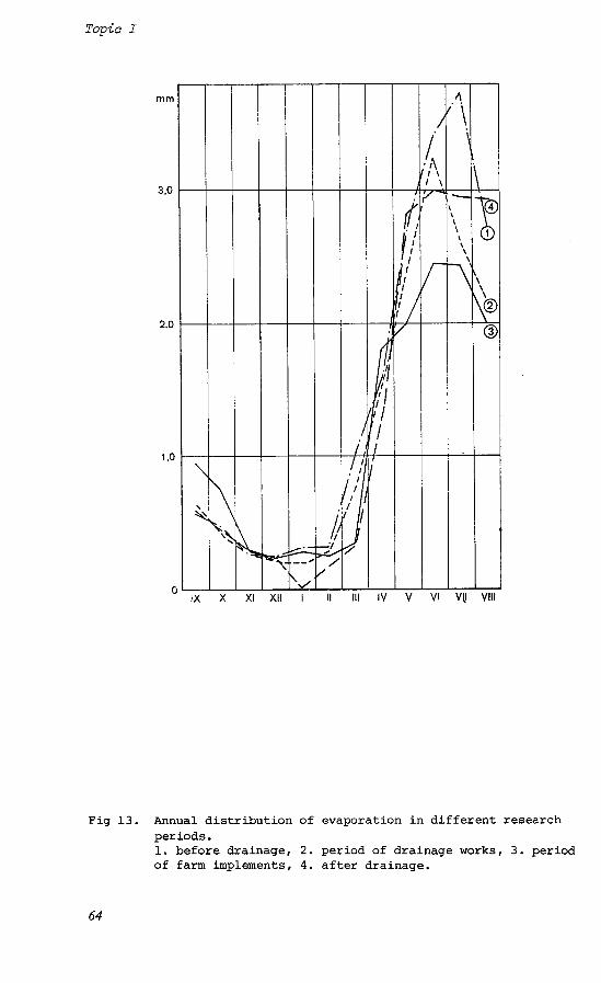
basin using the heat-balance method, considered to be the most exact. The attempts that were made did not, unfortunately, give the expected results as it was difficult to obtain values of all the parameters involved. For this reason use was made of Konstantinov's method (Konstantinov 1963, 19681, modified for Polish conditions (Debaki 1960). The results for the drained peat-bog showed that the evaporation decreased by about 15% as compared with the evapora- tion during the pre-reclamation period. In 1959 the annual evapora- tion was 526 mm; in 1960-1963 it ranged from 420 to 460 mm, the average being 444 mm. Comparing seasonal distributions, the decrease of evaporation was especially evident in summer (May to August). Only in autumn (September-October) were no distinct changes observed (Figure 13). No obvious change in air temperature and precipitation was noted.
significant dependence on the hydrological regime of the peat-bog as well as on the state of farm development. rate in 1959 seems to be a result of the high groundwater level. part of the decrease of evaporation in 1960-1961 was caused by the lowering of the groundwater level during a time when the original vegetation still existed. The considerable decrease of evaporation in 1962, especially in summer, resulted primarily from the start of post-reclamation farm development, ie from the destruction of the original flora before new species could develop fully. unusually high air temperatures in September (11.7 C) and October (8.7OC). increase in evaporation during the vegetation period as a result of an increase in meadow crops. This confirms the general opinion expressed by Shebeko (Shebeko, 1965) on the basis of research carried out in Byelorussia. Bavina and Malankina (Bavina & Malankina, 1969) also came to a general conclusion that a change of vegetation cover is the main factor which changes evaporation from a drained peat-bog .
the river profiles downstream and upstream of the peat-bog. The results show a 20% increase in runoff, as compared to the pre- reclamation period. This represents more than the decrease in evaporation from the basin. The runoff coefficient (runoff-to- precipitation ratio) also showed a tendency to increase, being on an average about 17%. There were increases in the runoff, in summer (May to August) and in autumn (September-October). Bulavko in his monograph notes the conspicuous increase of the runoff due to a decrease in evaporation during the first years after drainage.
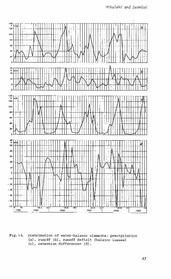
By analysising the individual hydrological components, the water balance of the peat-bog for a five-year period (1959-1963) was compiled. This used the method of selected wells developed by Dgbski (Dgbski 1963). of the peat-bog were used to calculate the states of storage. storage was included in the water-balance definition as a sum of groundwater storage and surface retention. It was assumed that in summer only groundwater storage occurs, whilst in winter the total storage was calculated from the water-balance equation (Lesniak, 1964).
An analysis of the annual distribution of evaporation shows a
The high evaporation
The high value of evaporation in the autumn was a result of 0
Finally, in the last year (1963) there was a marked
The peat-bog runoff was calculated from the difference between
Observations from two wells on each side Total
The structure of the water balance is clearly illustrated
59

Topic I
by the changes in storage. A positive storage difference can be found, as a rule, in autumn and in winter (October to March). In 1962 this positive difference was observed until summer which is exceptional. In summer (May to July) negative differences are normal, which may continue until autumn (Table 7, Figure 14).
The analysis has revealed no evidence to permit the attribution of the increase in runoff to precipitation. This increase was found to be due essentially to a decrease of storage. As a result of reclamation, water was drained from the peat-bog and the surround- ing catchment are. summer of 1963, when towards the end of zhe balance period quite a high runoff was accompanied by a high evaporation value, almost twice as high as the precipitation of that period. Thus it can be concluded that drainage of a low peat-bog surrounded by small areas of high permeability, can disturb the balance, not only of the peat-bog itself but also of the whole surrounding catchment area. This shows the need for investigations over the whole catchment area since only in this way is it possible to understand the changes which may follow reclamation works.
This can be illustrated by the situation during
References
Bavina, L. G., Malankina, Y. P. 1969. Vliyaniye ossusheniya na elementy girometeorologicheskogo rezhima poimennogo nizinnogo bolota (na primere Luninskogo bolotnogo massiva) . the components of the hydrometeorological regime of a low-moor illustrated by the Luninskiy bog). Trudy GGI, issue 177. Leningrad.
Bortkiewicz, A. 1969. Stacja begienne PIHM w Grzdku woj. bialostockie. (Swamp station of SIHM in Gr;dek/Bialystok province). Biul. PIHM, No. 4.
Bulavko, A. G. 1971. Vodny balans rechnikh vodosborov. Osnovnye Zakonomernosti, metody rascheta i problemy preobrazovaniya. (Water balance of river catchments. Basic relationships, methods of compu- tation and problems of transformation). Leningrad, Gidrometeozdat.
Debaki, K. 1960. Szczegolowy bilans wodny rzeki Wieprze w Kozminie jako przyklad rozwiazania rzwna: bilansu metode studzien wybranych (Detailed water balance of Wieprz river in Kozmin as an example of the solution of balance equations by the method of selected wells). Rocz. Nauk roln., No. F-74-3.
Dgbski. 1963. Ptzystosowanie nomogramu Konstantinova do oblicze; parowania terenowego w Polsce. (Use of the Konstantinov monograph for the computation of evaporation from watersheds in Poland]. Prace i Studia KIGW PAN. No. 6.
Ivanov, K. E. 1953. Gidrologiya bolot. (Hydrology of swamps). Leningrad, Gidrometeoizdat.
Konstantinov, A. P. 1963, 1968. Ispareniye v prirode. (Evapora- tion in nature) . Leningrad , Gidrometeoizdat . Lesniak, E. 1964. Wplyw melioracji na odplyw na przykladzie zlewni gzrnej Suprasli (Effect of drainage on runoff as exemplified by a drainage basin in the Upper Suprasl) . (Doctor's thesis). Warsaw,
(Effect of drainage on
Cosp. wodna-
60

MikuZski and Lesniak
Institute of Technology, Faculty of Sanitary and Water Engineering, Warsaw.
Maksimov, A. 1965. Torf i ego uzytkowanie w rolnictwie. Wyd.ll (Peat and its use in agriculture). 2 ed. Warszawa, PWRIL.
Orsztynowicz, J. 1963. Proba ustalenia retencji gruntowej na torfowisku Michalowo-Imszer metoda koncowych rzznic Kamienskiego. (An attempt to evaluate groundwater storage in the Michlowo-Imszer peat-bog by the Kamienski method of finite differences). Biul. PIHM, No. 7 also summary in: Cosp. wodna - Biul. PIHM, No. 3.
Stolerska, A. 1962. Proba ustalenia pojemnosci wodnej zloz torfowych na terenach Polski. capacity of peat deposits in Poland). Prace i Studia KLIGW, No. 111, Warsawa.
Shebeko, V. F. 1965. Ispareniye s bolot i balans pochvennoi vlagi. (Evaporation from swamps and soil moisture balance). Minsk, "Urozhai" .
CAn attempt to evaluate the water
Fig. 9. Map of peatbogs in Poland (after Maksimov, 1965)
61

Topic I
Fig 10. Map of the Michalowo-Imszar peatbog.
Fig 11. General view of the Swamp Station at Grodak (phot. by 2. Mikulski)
62

MikuZski and Lesniak L! a, c, : 2 I 0 L! b w 0
b
.rl E
63
Topic 1
! \. \
\
\ \
vu L 111 IV v
\
\ \
\ e @
Vlll
Fig 13. Annual distribution of evaporation in different research periods. 1. before drainage, 2. period of drainage works, 3. period of farm implements, 4. after drainage.
64
Mikulski and Lesniak
20 H 15
10
5
Fig.14. Distribution of water-balance elements: precipitation (a), runoff (b), runoff deficit (balance losses) (c), retention differences (d) .
65

Topic I
N I
mII
om
9'9
OF
N
N
<d
rlN
mo
rlrl
mw
Nrl
*.
corn
99
cow
mco
rl
?a
m
o
Ir
04
w
w
mm
rl-l
II
0
0
mw
m
m
rlrl
$6
CE
w
rn w
om

MikuZski and Lesniak
INTRODUCTION
Adequate drainage is essential for the cultivation of peat soils in the temperate zone, but such drainage causes physical changes which never end. whilst bulk density and compaction increase. information on this topic of importance from the agricultural engineering point of view.
of the FRG (Table 8) shows the necessity of drainage.
The macropore space and permeability decrease This paper gives
The principal water balance data of the north-western regions
Table 8. Principal water balance data for high-bog grassland (1951/58)
Period Rainf a 11 Run-of f Evaporation Storage
Winter 3 64 176 93 +9 5
Summer 378 75 398 -95
Year 742 251 491 0
Subsidence of peat surface resulting from drainage
Figure 15 shows how the solid matter content, macropore space, subsidence and permeability are related for the complete drainage period. This has been found to hold in all drained peat areas of Western Europe, Canada, Scandinavia and Yugoslavia. The magnitude of the alterations change with the kind of peat and degree of moisture content as with the intensity and duration of drainage. The external indication of the physical effects of peat drainage is the surface subsidence which can be seen around piles which have been driven into the mineral subsoil. In the past two decades predictions have been made about the anticipated subsidence in sixty moorlands. Where it was possible to verify these predictions by measurements after drainage a good correlation was obtained.
In order to predict subsidence the apparent density of the peat was measured and Haleakorpi's empirical formula for peat subsidence was applied (Segeberg 1960). This states that
S = a (0.080 T + 0.066)
where: S is the subsidence, a is factor of relative peat density, and T is the thickness of the peat layer (m).
67