van ness-udc - dc office of planning · june 2011 van ness-udc commercial corridor enhancement...
TRANSCRIPT

JUNE 2011
VAN NESS-UDCCOMMERCIAL CORRIDOR
ENHANCEMENT STUDY
C O N N E C T I C U T AV E N U E N WWA S H I N G T O N , D C
PREPARED FOR:NATIONAL CAPITAL REGION TRANSPORTATION
PLANNING BOARD OF THE METROPOLITAN WASHINGTON COUNCIL OF GOVERNMENTS
DISTRICT OF COLUMBIA OFFICE OF PLANNING (OP)
PREPARED BY:RHODESIDE & HARWELL
LANDSCAPE ARCHITECTURE & PLANNING
2
A C K N O W L E D G E M E N T S
The Van Ness-UDC Metro Commercial Corridor Enhancement Study was funded by a 2011 Metropolitan Washington Council of Governments Transportation Land-use Connections Grant to the District of Columbia Office of Planning (DCOP). During the study, DCOP sought the active involvement and participation of DC government agencies, officials, area residents, property owners, ANC Commissioners and the Univer-sity of the District of Columbia.
CITY OFFICIALS
Vincent GrayMayor, District of Columbia
Mary ChehCouncil Member, Ward 3
Advisory Neighborhood Commission ANC 3F:•3F01 Adam Tope•3F02 Karen Perry•3F03 Karen Beiley•3F04 Tom Whitley•3F05 Roman Jankowski•3F06 Cathy Wiss•3F07 Bob Summersgill
Harriet TregoningDirector, DC Office of Planning
Geraldine GardnerAssociate Director, DC Office of Planning

3
PROJECT MANAGEMENT STAFF
Office of PlanningAndrea Limauro, Neighborhood Planning Coordinator, Ward 3
Consultants:Rhodeside & Harwell, Incorporated Landscape Architecture & PlanningElliot Rhodeside, FASLA, DirectorDeana Rhodeside, Ph.D., DirectorLucas Bonney, RLA, Landscape Architect
SPECIAL THANKS TO:
A special thanks to Sarah Crawford at the Metropolitan Washington Council of Governments for her guidance and support. Thanks to the DDOT and DDOE staff that have provided input and comments through-out the Study process.
Thank you as well to all of the University of the District of Columbia (UDC) administrators, Department of Architecture staff, and students who actively participated in the conceptual design and community outreach processes. A very special thanks to the following:
•Ralph Belton, Chairperson, UDC Division of Urban Architecture and Community Planning
•Wanda Briscoe, UDC Architecture Student
•Jill W. Comstock, UDC Architecture Student
•Carlos M. Diaz, UDC Architecture Student
•Ameer S. McCall, UDC Architecture Student

4
5
CONTENTS
CHAPTER 1: INVENTORY & ANALYSIS
CHAPTER 2: OPPORTUNITIES
CHAPTER 3: GUIDELINES & RECOMMENDATIONS
INVENTORY & ANALYSIS . . . . . . . . . . . . . . . . . . . . . . . . . 14
ACKNOWLEDGEMENTS . . . . . . . . . . . . . . . . . . . . . . . . . . . 2INTRODUCTION . . . . . . . . . . . . . . . . . . . . . . . . . . . . . . . . . 6PROJECT LOCATION . . . . . . . . . . . . . . . . . . . . . . . . . . . . . 6PURPOSE OF THE PROJECT . . . . . . . . . . . . . . . . . . . . . . . 6PROJECT GOALS . . . . . . . . . . . . . . . . . . . . . . . . . . . . . . . 10COMMUNITY PROCESS . . . . . . . . . . . . . . . . . . . . . . . . . . . 11SUMMARY OF DESIGN APPROACH. . . . . . . . . . . . . . . . . . 11
LOW IMPACT DEVELOPMENT (LID) OPPORTUNITIES . . 23STREETSCAPE & PLAZA OPPORTUNITIES . . . . . . . . . . . 28AREA “A” OPPORTUNITIES . . . . . . . . . . . . . . . . . . . . . . . 30AREA “B” OPPORTUNITIES . . . . . . . . . . . . . . . . . . . . . . . 32AREA “C” OPPORTUNITIES . . . . . . . . . . . . . . . . . . . . . . . 34STREETSCAPE & PLAZA PRECEDENT IMAGES . . . . . . . 36
LID STREETSCAPE IMPROVEMENT PLAN . . . . . . . . . . . 41LID STREETSCAPE TYPE 1 . . . . . . . . . . . . . . . . . . . . . . . . 44LID STREETSCAPE TYPE 2 . . . . . . . . . . . . . . . . . . . . . . . 46LID STREETSCAPE TYPE 3 . . . . . . . . . . . . . . . . . . . . . . . 48SIDE STREET IMPROVEMENTS PLAN . . . . . . . . . . . . . . . 50PRIVATE PLAZA IMPROVEMENTS PLAN . . . . . . . . . . . . 58CORRIDOR IMPROVEMENTS SUMMARY PLAN . . . . . . . 70
INTRODUCTION / SUMMARY OF WORK
APPENDIXCOMMENTS FROM STAKEHOLDER MEETING #1 . . . . . . 74COMMENTS FROM CHARRETTE MEETING #2 . . . . . . . . 762010 COMPREHENSIVE PLAN EXCERPTS . . . . . . . . . . . 78EXISTING UTILITY PLAN (PROVIDED BY DDOE) . . . . . . 80VEAZEY TERRACE CONCEPT (BY GOROVE/SLADE) . . 81PROPOSED UDC STUDENT CENTER PLAZA (BY LAI) 82
6
I N T R O D U C T I O N
The Van Ness-UDC Metro Commercial Corridor Enhancement Study was funded by a 2011 Transportation/Land-Use Connections Technical Assistance Grant received by the District of Columbia Office of Planning (DCOP). The project was funded by the National Capital Region Transportation Planning Board of the Metropolitan Washington Council of Governments, who retained Rhodeside & Harwell, planners and landscape architects, to collaborate with DCOP staff and community stakeholders on this study.
P R O J E C T L O C A T I O N
The project area comprises a segment of Connecticut Avenue, NW, bounded by Albemarle Street to the north and Tilden Street to the south. The project area extends one block to both the east and west of Connecticut Avenue in order to incorporate the adjacent side streets. See the Project Location Map (right).
Several earlier planning studies, including in particular the Neighborhood Sustainability Indicators Pilot Project (NSIP), identified specific issues voiced by residents within the project area. Issues include:
> Poor pedestrian safety at crosswalks> Interrupted pedestrian and bicycle accessibility> Lack of pervious surfaces> Unfriendly and unattractive public spaces> Mediocre architecture
In addition, the recently updated 2010 Comprehensive Plan identifies several policy recommendations that are relevant to public space and streetscape design within the District of Columbia. The current study responds to some of these streetscape policy initiatives. A full listing of these policies is located in the Appendix of this report.
P U R P O S E O F T H E P R O J E C T
INTRODUCTION
7
PROJECT LOCATION
INTRODUCTION
STUDY BOUNDARY
PROJECT AREA

8
HEALTHY STREAM BANK ALONG SOAP STONE CREEK(below 29th Street NW and Audubon Terrace NW)
SOAPSTONE VALLEY PARK: EVIDENCE OF SEVERE EROSION
SOAPSTONE VALLEY PARK: EVIDENCE OF SEVERE EROSION
FENWICK BRANCH TRIBUTARY OF ROCK CREEK (untreated stormwater discharge carries trash from streetscape)
EXISTING SOAP STONE CREEK OUTFALL(untreated stormwater discharge from streetscape)
9
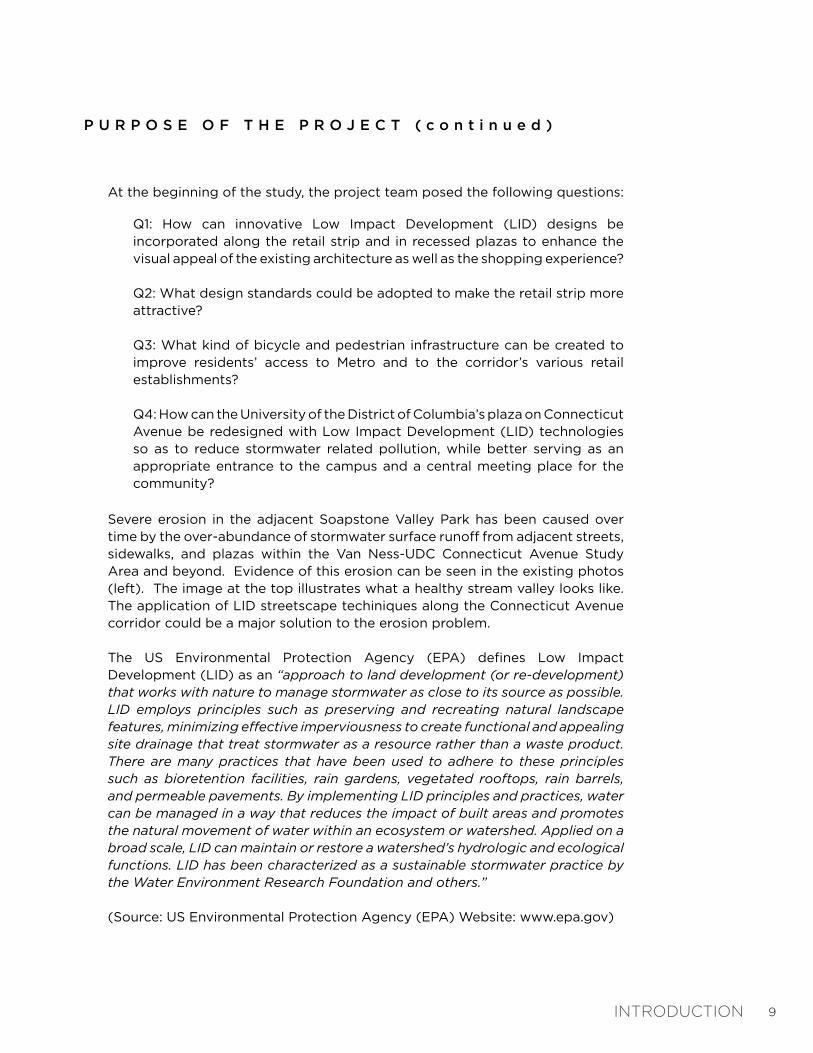
P U R P O S E O F T H E P R O J E C T ( c o n t i n u e d )
Severe erosion in the adjacent Soapstone Valley Park has been caused over time by the over-abundance of stormwater surface runoff from adjacent streets, sidewalks, and plazas within the Van Ness-UDC Connecticut Avenue Study Area and beyond. Evidence of this erosion can be seen in the existing photos (left). The image at the top illustrates what a healthy stream valley looks like. The application of LID streetscape techiniques along the Connecticut Avenue corridor could be a major solution to the erosion problem.
The US Environmental Protection Agency (EPA) defines Low Impact Development (LID) as an “approach to land development (or re-development) that works with nature to manage stormwater as close to its source as possible. LID employs principles such as preserving and recreating natural landscape features, minimizing effective imperviousness to create functional and appealing site drainage that treat stormwater as a resource rather than a waste product. There are many practices that have been used to adhere to these principles such as bioretention facilities, rain gardens, vegetated rooftops, rain barrels, and permeable pavements. By implementing LID principles and practices, water can be managed in a way that reduces the impact of built areas and promotes the natural movement of water within an ecosystem or watershed. Applied on a broad scale, LID can maintain or restore a watershed’s hydrologic and ecological functions. LID has been characterized as a sustainable stormwater practice by the Water Environment Research Foundation and others.”
(Source: US Environmental Protection Agency (EPA) Website: www.epa.gov)
Q1: How can innovative Low Impact Development (LID) designs be incorporated along the retail strip and in recessed plazas to enhance the visual appeal of the existing architecture as well as the shopping experience?
Q2: What design standards could be adopted to make the retail strip more attractive?
Q3: What kind of bicycle and pedestrian infrastructure can be created to improve residents’ access to Metro and to the corridor’s various retail establishments?
Q4: How can the University of the District of Columbia’s plaza on Connecticut Avenue be redesigned with Low Impact Development (LID) technologies so as to reduce stormwater related pollution, while better serving as an appropriate entrance to the campus and a central meeting place for the community?
At the beginning of the study, the project team posed the following questions:
INTRODUCTION
10
P R O J E C T G O A L S
The following goals were used at the first community meeting to inspire the discussion of a vision for the Connecticut Avenue corridor:
> Explore LID design techniques and identify implementation opportunities along the corridor in order to create a more sustainable urban environment.
> Provide recommendations for revitalizing public spaces along the corridor in an effort to encourage community gathering, stimulate pedestrian activity, and increase retail use.
> Establish streetscape typologies that will improve the identity and aesthetic quality of the corridor.
> Improve pedestrian and bicycle connections between the Van Ness-UDC Metro station, existing businesses, and adjacent communities and institutions.
P U R P O S E O F T H E P R O J E C T ( c o n t i n u e d )
Introducing LID techniques to the corridor will not only benefit the community’s enjoyment of the streetscape but, more importantly, will improve the environmental health of the local watershed, the Potomac River, and the Chesapeake Bay.
Therefore, the main purpose of this study has been to investigate ways to improve the streetscape environment along this section of Connecticut Avenue, NW, through the application of LID techniques and principles. The guidelines & recommendations provided in this report directly reference the Public Realm Design Manual (PRDM), which was developed by The District Office of Planning (OP) and District Department of Transportation (DDOT). The PRDM is a “summary of the District of Columbia regulations and specifications for the design of public space elements.” (PRDM, June 2010).
This study does not provide detailed streetscape design or construction documentation. In addition, this study does not recommend specific furnishings, paving materials, or plant species. The final recommendations presented at the end of this report are suggestions only, and are not intended to be built as shown.
Depending on funding and other considerations, this document will be used to guide either the development of a single corridor-wide streetscape construction project, or the development of several LID demonstration projects. This study will also guide the design review of private sector streetscape improvements.
INTRODUCTION

11
S U M M A R Y O F D E S I G N A P P R O A C H
The following is an overview of what was discovered during the corridor study process and how it was translated into a clear design approach.
The Van Ness-UDC Connecticut Avenue corridor is comprised of several plazas, broad streetscapes, and large intersections. Due to the corridor’s close proximity to Soapstone Valley Park, which eventually drains to Rock Creek, the Potomac River, and the Chesapeake Bay, this study has focused on identifying ways that Low Impact Development (LID) can provide the basis for design improvements along the corridor. With an abundance of impervious pavement within the public right-of-way (ROW), there is great opportunity to showcase the potential for employing LID techniques and initiatives along this corridor.
In the Guidelines & Recommendations section of the report, the design team has identified specific areas where these improvements can be made.
C O M M U N I T Y P R O C E S S
The study process was informed by the following meetings with stakeholders, students and the public:
Meeting #1 - February 8th, 2011: Steering Committee & Stakeholders Kick-off
Meeting #2 - March 14th, 2011: Charrette Concept Development with Steering Committee, Residents, Stakeholders & Students
Meeting #3 - April 13th, 2011: Work Session with UDC Students to refine the preferred concept
Meeting #4 - April 27th, 2011: Public Open House with Steering Committee, Residents, Stakeholders & Students
The primary message received from the meetings with stakeholders, community members, and students was to improve the safety along the corridor and the quality of public spaces, while also improving the overall sustainability of the public realm. A full summary of all meeting comments is provided in the Appendix.
INTRODUCTION

12
13
I N V E N T O R Y & A N A L Y S I S
CHAPTER 1

14
C H A P T E R 1 :I N V E N T O R Y & A N A L Y S I S
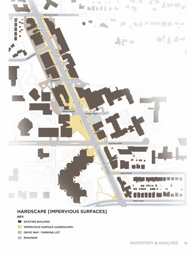
The Inventory & Analysis Chapter identifies the most important physical and environmental elements found within the corridor. Throughout the process of documenting each existing condition category, the team identified the areas that are critical to change in order to improve stormwater management and upgrade the overall corridor streetscape. Most of the information was acquired from aerial photography analysis, site visits, DC Government database information, and previous planning studies.
Inventory & Analysis Maps:
1. Hardscape (Impervious Surfaces)2. Softscape (Pervious Surfaces)3. Topography & Hydrology4. Transportation & Pedestrian Mobility5. Metrorail Infrastructure (Underground)6. Streetscape Character
Inventory & Analysis Maps Summary:
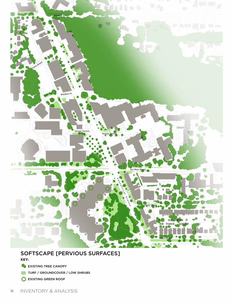
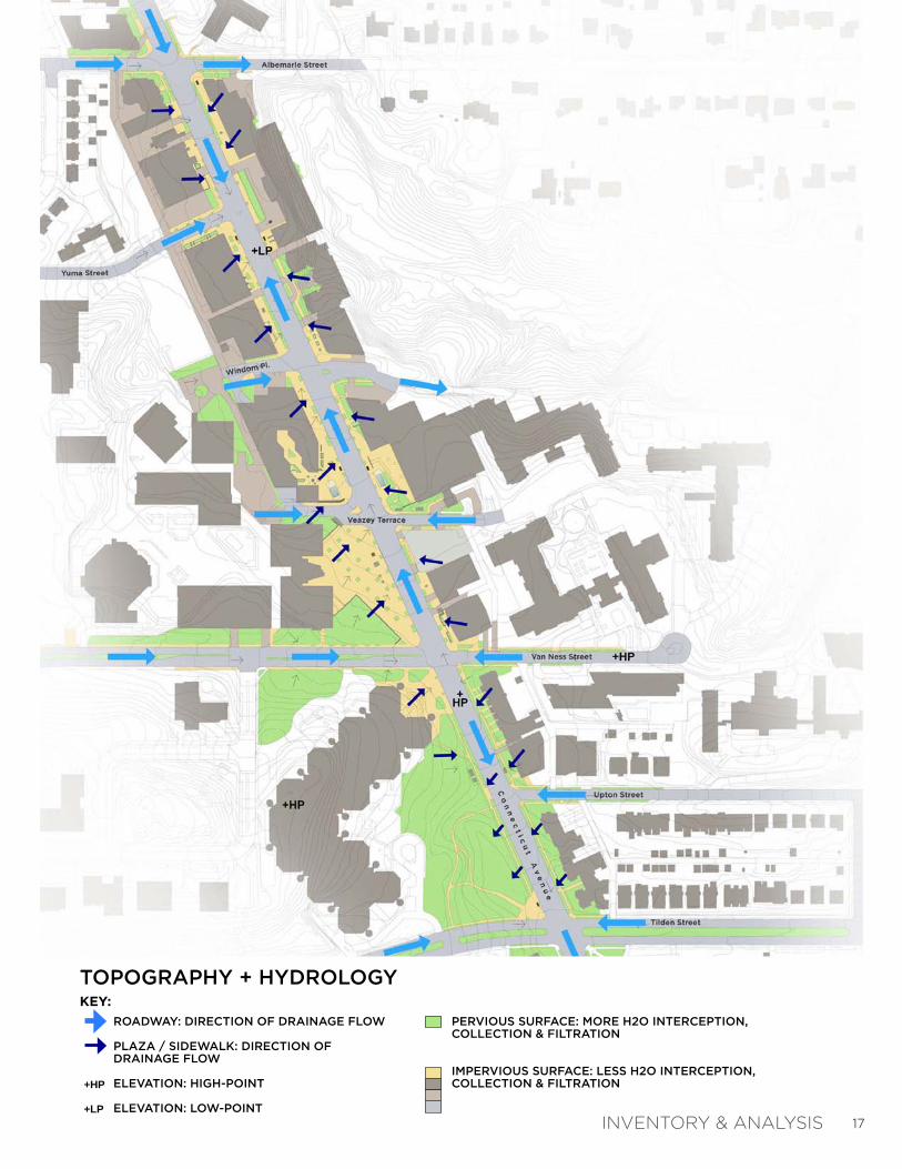
As apparent in the Hardscape Map (right), there is an overabundance of impervious surfaces along the corridor. In contrast, the Softscape Map (next page) reinforces the lack of pervious surfaces mainly within the civic core area, which allows more runoff to quickly flow unchecked into the stormwater system and onto the waterways of Soapstone Valley Park. In addition, the rolling topography and steep slopes, as indicated on the Topography & Hydrology Map (page 17), results in even faster runoff during heavy rain events. The combination of these conditions creates a greater risk for erosion in the adjacent stream valley.
The remaining three maps document existing pedestrian conditions, Metrorail underground infrastructure, and general streetscape character along the corridor. This information helped to inform the development of the “streetscape & plaza opportunity areas”, which are detailed in the next chapter.
INVENTORY & ANALYSIS
15
HARDSCAPE [IMPERVIOUS SURFACES]KEY:
INVENTORY & ANALYSIS
EXISTING BUILDING
IMPERVIOUS SURFACE (HARDSCAPE)
DRIVE WAY / PARKING LOT
ROADWAY
16
SOFTSCAPE [PERVIOUS SURFACES]
INVENTORY & ANALYSIS
EXISTING TREE CANOPY
TURF / GROUNDCOVER / LOW SHRUBS
EXISTING GREEN ROOF
KEY:
17
TOPOGRAPHY + HYDROLOGY
INVENTORY & ANALYSIS
ROADWAY: DIRECTION OF DRAINAGE FLOW
PLAZA / SIDEWALK: DIRECTION OF DRAINAGE FLOW
ELEVATION: HIGH-POINT
ELEVATION: LOW-POINT
+HP
+LP
PERVIOUS SURFACE: MORE H2O INTERCEPTION, COLLECTION & FILTRATION
IMPERVIOUS SURFACE: LESS H2O INTERCEPTION, COLLECTION & FILTRATION
KEY:

18
TRANSPORTATION + PEDESTRIAN MOBILITYKEY:
INVENTORY & ANALYSIS
FUTURE BICYCLE BOULEVARD
EXISTING SIGNED BIKE ROUTE
SIGNALIZED INTERSECTIONS [WITH PEDESTRIAN COLLISIONS]
(Source: RCWII Livability Study)
METRORAIL LINE (UNDERGROUND)
METRORAIL STATION
BUS ROUTE
BUS STOP
BUS ROUTE (TEMPORARILY DISCONTINUED)
BUS STOP (TEMPORARILY DISCONTINUED)
EXISTING PAVING / SIDEWALK
EXISTING PLANTING
M

19
METRORAIL INFRASTRUCTURE [UNDERGROUND]KEY:
INVENTORY & ANALYSIS
METRORAIL TUNNEL
METRORAIL STATION
METRO ELEVATOR
METRO AIR VENTS (WITH VENT SHAFT)
METRO SUBSTATION (WITH EASMENT)

20
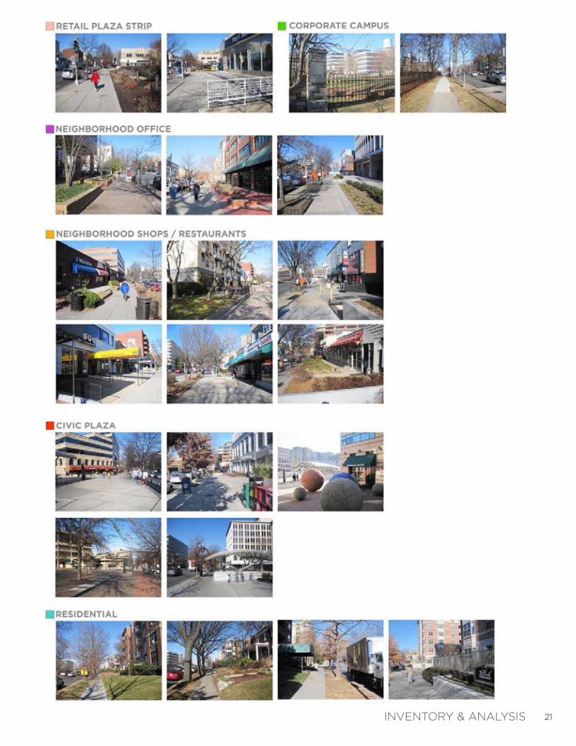
EXISTING STREETSCAPE CHARACTERKEY:
INVENTORY & ANALYSIS
CORPORATE CAMPUS
CIVIC PLAZA
NEIGHBORHOOD OFFICE
NEIGHBORHOOD MIXED-USE OFFICE / COMMERICAL
RESIDENTIAL
RETAIL PLAZA / STRIP
21INVENTORY & ANALYSIS

22

23
O P P O R T U N I T I E S
CHAPTER 2
The Opportunities Chapter merges the various layers of information collected in the Inventory & Analysis Chapter and identifies the specific areas along the corridor that represent potential streetscape improvement sites.
This chapter is divided into two sections: 1) Low Impact Development Opportunities; and 2) Streetscape & Plaza Opportunities.

24
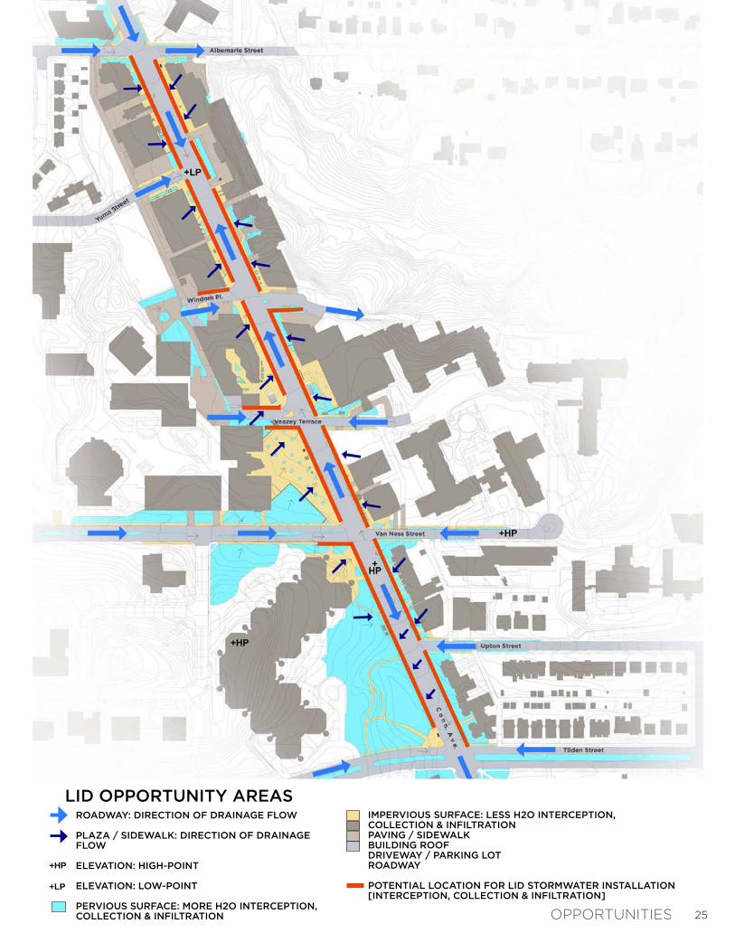
The LID Opportunity Areas map (right) illustrates the direction of surface water runoff as initially shown on the Existing Conditions Map: Topography + Hydrology. This map also indicates the locations where water runoff could be intercepted, collected, and then filtered before it enters the stormwater piping system that leads to the Soapstone Valley Park and, eventually, to Rock Creek and the Potomac River.
All of the LID Opportunity Areas for Stormwater Interception are located within the Connecticut Avenue right-of-way, which is owned and maintained by the District of Columbia. Therefore, it is required that all stormwater runoff be collected from publicly owned space, which includes the 1) “public parking” area; 2) sidewalk area; and 3) tree box / furnishing area, as defined in the Public Realm Design Manual (June 2010).
The precedent images on the following pages show various techniques and types of LID streetscape installations in a variety of urban settings. Specific LID recommendations are provided in the next Chapter.
C H A P T E R 2 : O P P O R T U N I T I E SL O W I M P A C T D E V E L O P M E N T ( L I D ) O P P O R T U N I T I E S
25
LID OPPORTUNITY AREAS
OPPORTUNITIES
ROADWAY: DIRECTION OF DRAINAGE FLOW
PLAZA / SIDEWALK: DIRECTION OF DRAINAGE FLOW
ELEVATION: HIGH-POINT
ELEVATION: LOW-POINT
PERVIOUS SURFACE: MORE H2O INTERCEPTION, COLLECTION & INFILTRATION
+HP
+LP
IMPERVIOUS SURFACE: LESS H2O INTERCEPTION, COLLECTION & INFILTRATIONPAVING / SIDEWALKBUILDING ROOFDRIVEWAY / PARKING LOTROADWAY
POTENTIAL LOCATION FOR LID STORMWATER INSTALLATION[INTERCEPTION, COLLECTION & INFILTRATION]

26
PRECEDENT IMAGES: LID STORMWATER FEATURES
OPPORTUNITIES

27
PRECEDENT IMAGES: LID STORMWATER FEATURES
OPPORTUNITIES

28
C H A P T E R 2 : O P P O R T U N I T I E SS T R E E T S C A P E & P L A Z A O P P O R T U N I T I E S
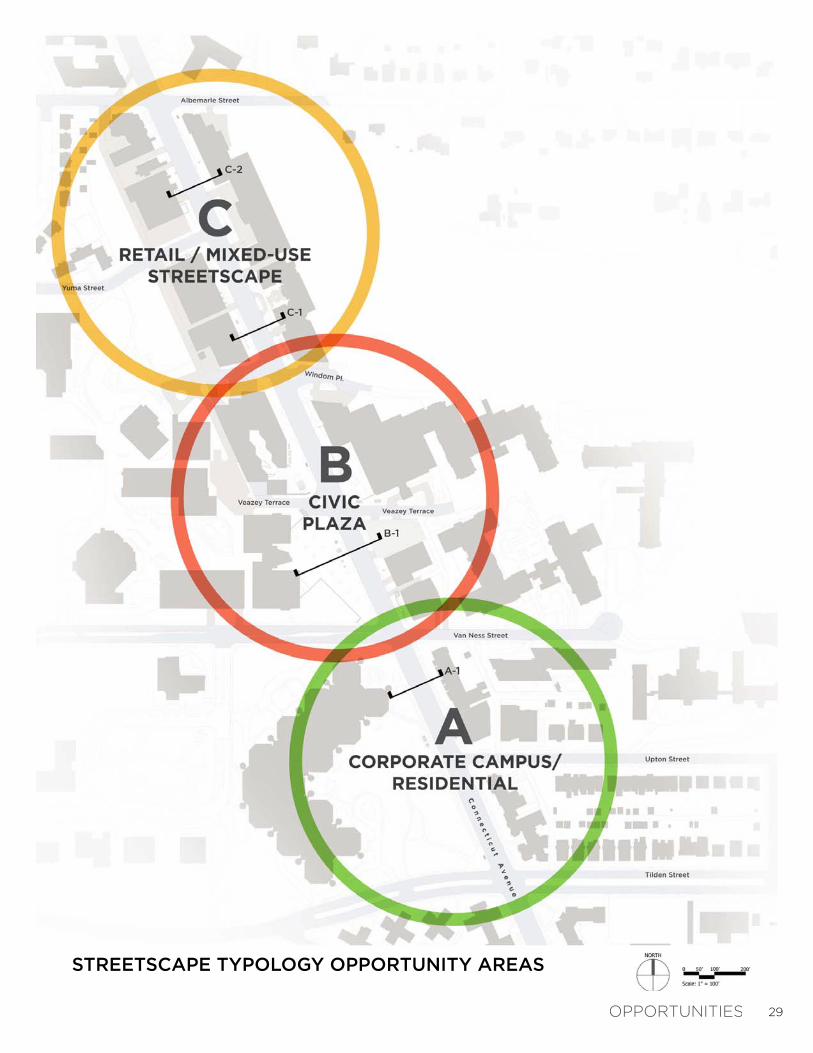
Parallel to identifying specific LID opportunities along the corridor, the team developed three (3) streetscape typology opportunity areas, which are shown on the Streetscape Typology Opportunity Areas map (right). These typologies were developed using the Existing Streetscape Character Map, which initially categorized the study area into diverse architectural themes, streetscape types, and spatial uses.
These streetscape typologies or “themes” can help to guide and organize future LID improvements, while creating a clear and unified corridor identity. The next few pages document the specific opportunities and issues found within each area.
The streetscape and plaza opportunities exercise gave the team a better understanding as to which types of LID streetscape improvements were appropriate to the character and context of each area.
OPPORTUNITIES
29
STREETSCAPE TYPOLOGY OPPORTUNITY AREAS
OPPORTUNITIES
30
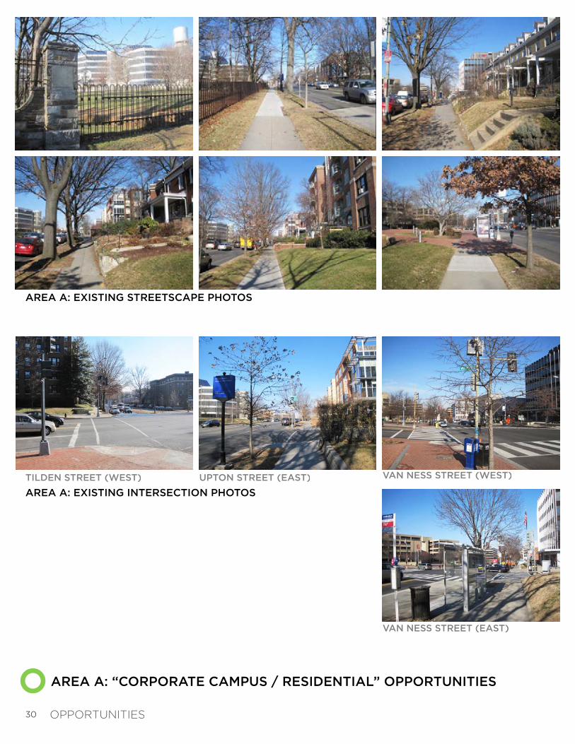
AREA A: “CORPORATE CAMPUS / RESIDENTIAL” OPPORTUNITIES
AREA A: EXISTING STREETSCAPE PHOTOS
VAN NESS STREET (WEST)
VAN NESS STREET (EAST)
AREA A: EXISTING INTERSECTION PHOTOS
TILDEN STREET (WEST) UPTON STREET (EAST)
OPPORTUNITIES

31
AREA A: EXISTING CONDITIONS - CROSS SECTION #A-1
S U M M A R Y :A R E A ‘ A ’ S T R E E T S C A P E O P P O R T U N I T I E S
This southern-most portion of the study area is defined by large shade trees, narrow sidewalks, corporate park space, a variety of homes, neighborhood schools and small businesses. The existing photos and cross section help to illustrate these qualities.
Due to the abundance of large existing trees, opportunities for re-structuring the streetscape to help improve stormwater quality are somewhat limited.
Streetscape Opportunities for Area ‘A’ include: 1) Improving plantings and grading within the existing tree strip. The existing compacted lawn areas between the sidewalk and curb allow water to flow unchecked into the stormwater catch basins along Connecticut Avenue. By replacing the existing lawn in the tree strip with groundcover plants and carefully re-grading the soil with a concave cross section (to collect water), water runoff could be slowed and infiltrated into the groundwater table before entering the stormwater system.
These ideas are explained and illustrated further in Chapter 3: Guidelines & Recommendations.
OPPORTUNITIES
32
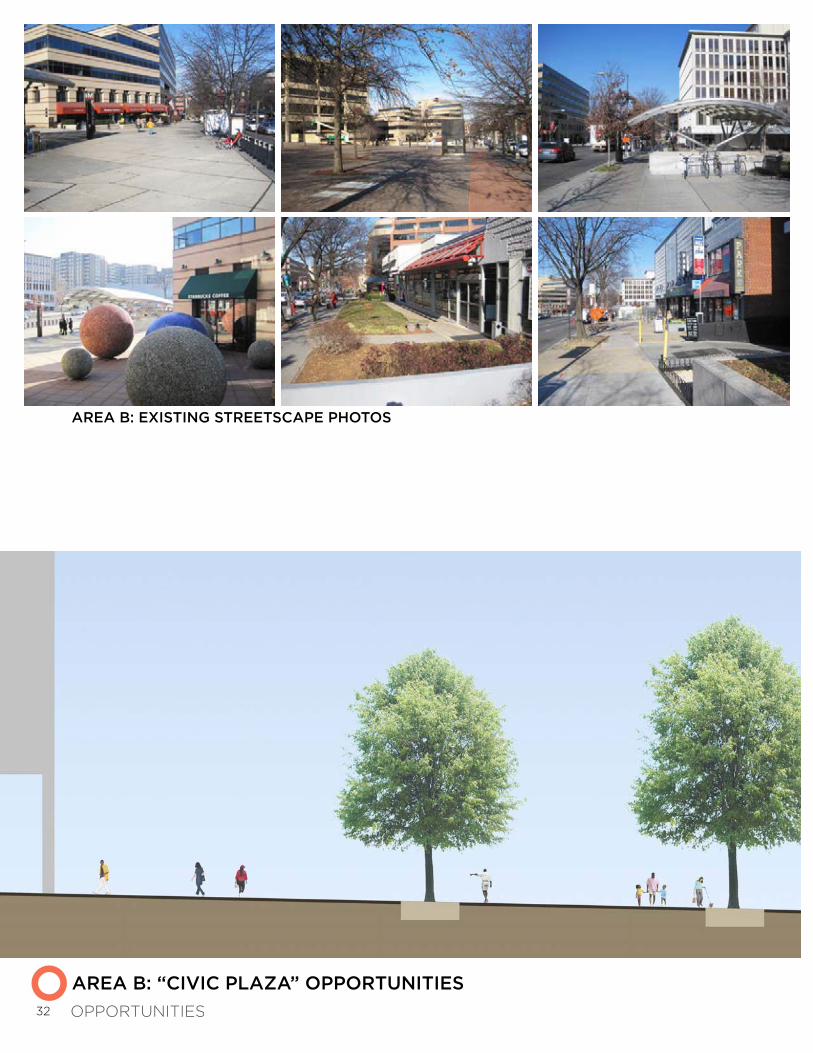
AREA B: “CIVIC PLAZA” OPPORTUNITIES
AREA B: EXISTING STREETSCAPE PHOTOS
OPPORTUNITIES

33
AREA B: EXISTING CONDITIONS - CROSS SECTION #B-1 AT UDC PLAZA (LOOKING NORTH)
AREA B: EXISTING INTERSECTION PHOTOS
WINDOM PLACE (WEST)
WINDOM PLACE (EAST)
VAN NESS STREET (WEST)
VAN NESS STREET (EAST)
VEAZEY TERRACE (WEST)
VEAZEY TERRACE (EAST)
S U M M A R Y : A R E A ‘ B ’ S T R E E T S C A P E O P P O R T U N I T I E SThe central portion of the study area is defined by large plazas, broad sidewalks, the Metrorail station entrances, various office buildings, restaurants, and retail establishments. The existing photos and cross section help to illustrate these qualities.
Most of the impervious pavement within the study corridor occurs within this area. Therefore, there is great opportunity for improvement using LID techniques in this area.
Opportunities for Area ‘B’ include: 1) Increase tree planting and LID planting areas along Connecticut Avenue in order to allow stormwater runoff to be intercepted and filtered before continuing into the stormwater system.
2) Increase streetscape furnishings and elements at existing plazas and along sidewalks in order to create a more attractive shopping environment for visitors and residents.
OPPORTUNITIES

34
AREA C: “RETAIL / MIXED-USE STREETSCAPE” OPPORTUNITIES
WINDOM PLACE (WEST) YUMA STREET
ALBEMARLE STREET
WINDOM PLACE (EAST)
AREA C: EXISTING INTERSECTION PHOTOS
AREA C: EXISTING STREETSCAPE PHOTOS
OPPORTUNITIES

35
AREA C: EXISTING CONDITIONS - CROSS SECTION #C-1
AREA C: EXISTING CONDITIONS - CROSS SECTION #C-2
S U M M A R Y :A R E A ‘ C ’ O P P O R T U N I T I E S
The northern portion of the study area is defined by small shops, a hotel, schools, and various large residential buildings. The existing photos and cross section help to illustrate these qualities.
Opportunities for Area ‘C’ include: 1) Increase tree planting and LID planting areas along Connecticut Avenue in order to allow stormwater runoff to be intercepted and filtered before continuing into the stormwater system.
2) Create a continuous tree planting strip along Connecticut Avenue.
3) Increase streetscape furnishings and elements at existing plazas and along sidewalks in order to create a more attractive shopping environment for visitors and residents.
These ideas are explained further in Chapter 3: Guidelines & Recommendations.
OPPORTUNITIES
36
C H A P T E R 2 : O P P O R T U N I T I E SS T R E E T S C A P E & P L A Z A P R E C E D E N T I M A G E S
During the development of the Corridor-wide Opportunities, the team collected various precedent images of successful streetscapes, parks, and LID installations in urban settings as a way to illustrate the great potential for the Connecticut Avenue corridor.
OPPORTUNITIES

37
PRECEDENT IMAGES: URBAN PLAZA ELEMENTS
OPPORTUNITIES

38
PRECEDENT IMAGES: STREETSCAPE ELEMENTS
OPPORTUNITIES

39
PRECEDENT IMAGES: WATER, PLANTS & ART FEATURES
OPPORTUNITIES

40
41
G U I D E L I N E S & R E C O M M E N D A T I O N S
CHAPTER 3
The Guidelines & Recommendations Chapter organizes the corridor into three distinct improvement plans:
1) LID Streetscape Improvements Plan 2) Side Street Improvements Plan 3) Private Plaza Improvements Plan
All recommended improvements are then summarized in the Corridor Improvements Summary Plan at the end of this chapter.

42
All recommended LID Streetscape Types (1, 2, and 3) are located within the public right-of-way (ROW) and are summarized on the pages that follow. Each LID streetscape type was determined based on the following conditions:
1. The existing dimensions of the streetscape and public space available2. The condition, size, and number of existing shade trees3. The existing topography and location of stormwater drains4. The existing streetscape character
Additional illustrations and details of each LID Streetscape Type are provided on the pages that follow. Please note that all sidewalk paving materials, planting materials, and furnishing types referenced in this report are for illustrative purposes only. Specific material types selected for this corridor shall conform to all DDOT Streetscape Standards. During this study’s process, London Pavers were selected as the preferred paving material for this study area (commercial areas only). Any changes or omissions to this selection in the future shall be reviewed and approved by DDOT.
EXISTING TREES TO BE PRESERVEDAll existing street trees (except those that are diseased or dead) are recommended to be preserved and protected. Some small street trees may need to be removed in locations where LID Stormwater Infiltration Plantings are recommended (See Streetscape Type “A”, page 44). All proposed street tree locations are shown on the LID Streetscape Plan Enlargements in the pages that follow.
C H A P T E R 3 : G U I D E L I N E S & R E C O M M E N D A T I O N SL O W I M P A C T D E V E L O P M E N T ( L I D ) S T R E E T S C A P E I M P R O V E M E N T S P L A N
GUIDELINES & RECOMMENDATIONS
STREETSCAPE TYPE 1: TREE PIT PLANTING EXTENSIONS - See pages 44-45 for details
STREETSCAPE TYPE 2: BIO-INFILTRATION PLANTING (LID) - See page 46 for details
STREETSCAPE TYPE 3: IMPROVED GROUNDCOVER (IN TREE STRIP) - See page 47 for details
STREETSCAPE TYPE 3: IMPROVED PLANTS (RESIDENTIAL LANDSCAPE)
EXISTING TREES TO BE PRESERVED
PLAN KEY:

43
LID STREETSCAPE IMPROVEMENTS PLAN
MENDATIONSGUIDELINES & RECOMM

44
LID STREETSCAPE TYPE 1: PLAN ENLARGEMENT
Streetscape Type 1 is applied to areas where existing trees prevent the full excavation that is needed for advanced constructions of LID bio-filtration tree plantings (as is illustrated by Streetscape Type 2). The Type 1 plan enlargement (below) recommends the planting of additional street trees, in some cases between existing street trees, yet still conforming to standard tree spacing as stated in the Public Realm Design Manual. Furthermore, the addition of groundcover or low shrubs within the tree box area will help to intercept stormwater on its way to the stormwater system.
The existing conditions photo (top right) illustrates the abundance of paving that currently exists between street trees. The conceptual visualization (bottom right) shows an increase in the amount of pervious surface: additional trees, low shrubs, and groundcover to help intercept runoff currently flowing unchecked into the gutter and storm system.
NOTE: All streetscape annotations shown below are referenced in the District’s Public Realm Design Manual (June 2011). The manual defines “Public Parking” as the area between the sidewalk and property line devoted to public open space and greenery (within the public right-of-way). This space is part of the City’s park and open space system and NOT intended for vehicular parking. Public space regulations that govern this area also apply to private property behind building restriction lines. These areas are often perceived as private landscapes that create a continuous park-like setting along public City streets.
S U M M A R YL I D S T R E E T S C A P E T Y P E 1
GUIDELINES & RECOMMENDATIONS

45
LID STREETSCAPE TYPE 1: CONCEPTUAL VISUALIZATION
EXISTING VIEW: SIDEWALK NEAR METRO WEST STATION(LOOKING NORTH)
GUIDELINES & RECOMMENDATIONS
46
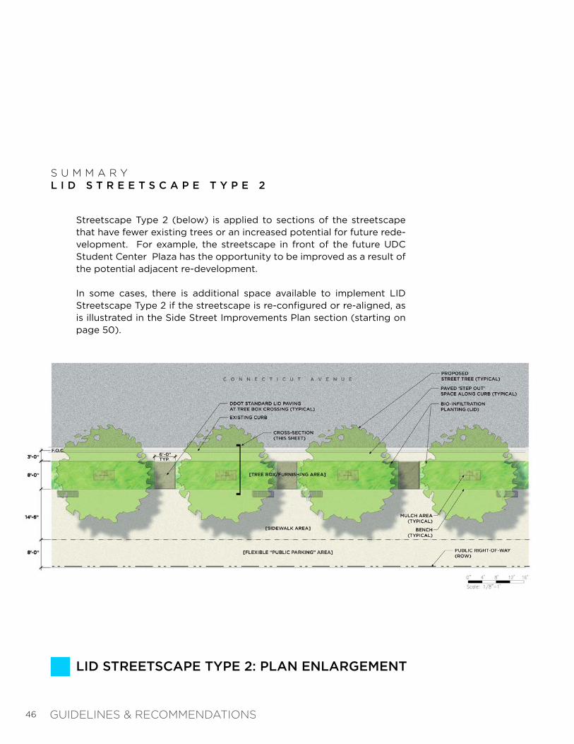
S U M M A R YL I D S T R E E T S C A P E T Y P E 2
LID STREETSCAPE TYPE 2: PLAN ENLARGEMENT
Streetscape Type 2 (below) is applied to sections of the streetscape that have fewer existing trees or an increased potential for future rede-velopment. For example, the streetscape in front of the future UDC Student Center Plaza has the opportunity to be improved as a result of the potential adjacent re-development.
In some cases, there is additional space available to implement LID Streetscape Type 2 if the streetscape is re-configured or re-aligned, as is illustrated in the Side Street Improvements Plan section (starting on page 50).
GUIDELINES & RECOMMENDATIONS
47
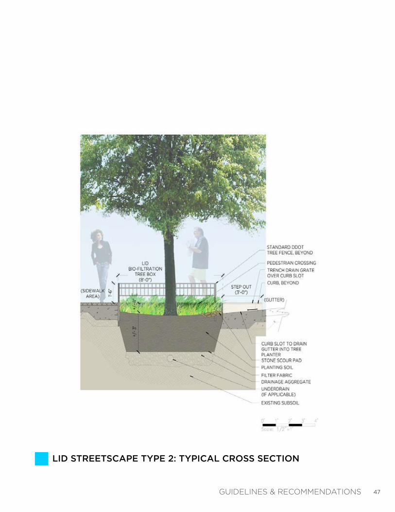
LID STREETSCAPE TYPE 2: TYPICAL CROSS SECTION
GUIDELINES & RECOMMENDATIONS
48
LID STREETSCAPE TYPE 3: IMPROVED PLANTINGS
EXISTING VIEW: RESIDENTIAL STREETSCAPE
S U M M A R YL I D S T R E E T S C A P E T Y P E 3
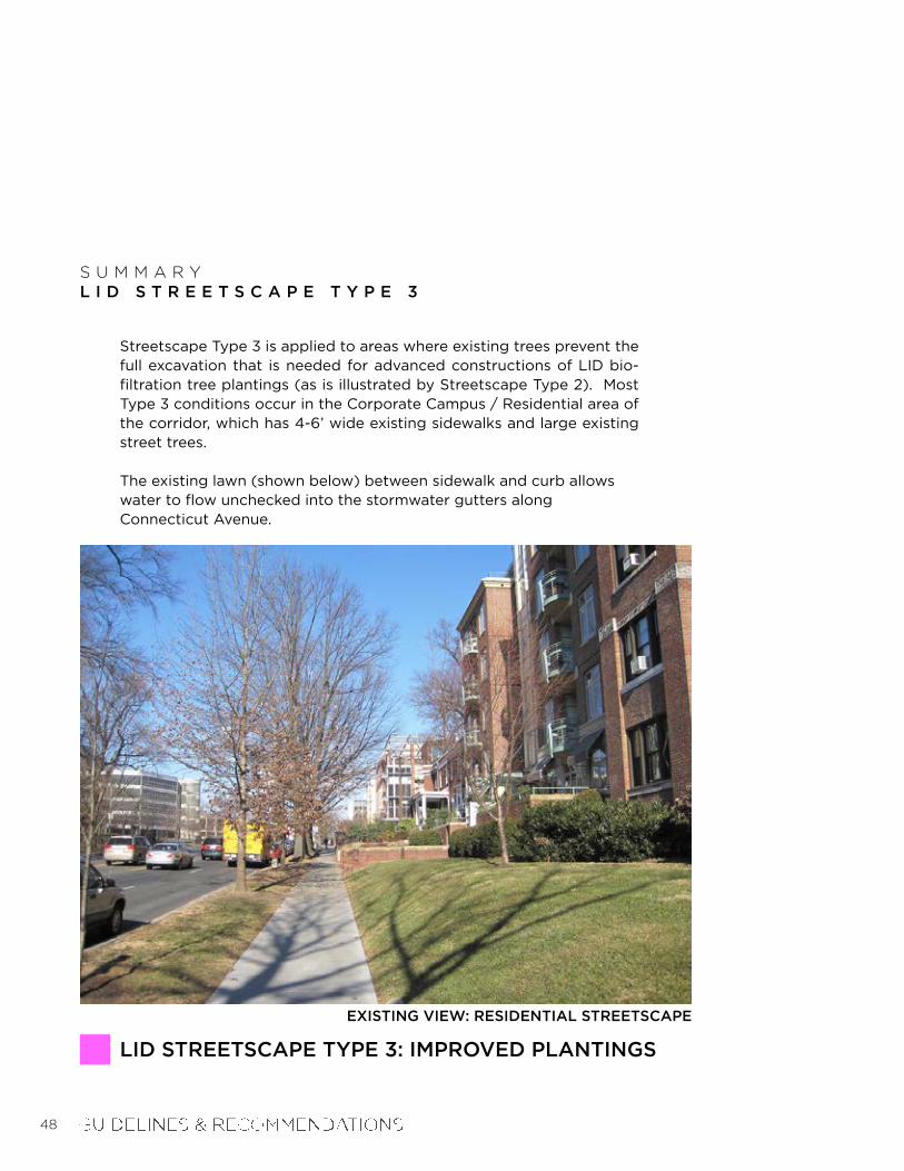
Streetscape Type 3 is applied to areas where existing trees prevent the full excavation that is needed for advanced constructions of LID bio-filtration tree plantings (as is illustrated by Streetscape Type 2). Most Type 3 conditions occur in the Corporate Campus / Residential area of the corridor, which has 4-6’ wide existing sidewalks and large existing street trees.
The existing lawn (shown below) between sidewalk and curb allows water to flow unchecked into the stormwater gutters along Connecticut Avenue.

49
CONCEPTUAL VIEW: STREETSCAPE TYPE ‘C’ PLANTINGS
LID STREETSCAPE TYPE 3: IMPROVED PLANTINGS
Improved plantings along the existing tree strip: Replacing the existing lawn and carefully re-grading the soil with a concave cross section (where possible) would improve interception and filtering of runoff before entering into the stormwater system.
GUIDELINES & RECOMMENDATIONS

50
Improvements to three (3) of the side streets along the west side of the study area are featured in this section, which can serve as models for other side streets in the study area. The pedestrian crossings at Veazey Terrace, Windom Place, and Yuma Street are detailed on the pages that follow. All recommendations utilize the proposed LID Streetscape Types 1, 2, and 3 as presented in the previous section.
C H A P T E R 3 : G U I D E L I N E S & R E C O M M E N D A T I O N SS I D E S T R E E T I M P R O V E M E N T S P L A N
10
11
12
SIDE STREET IMPROVEMENTS
VEAZEY TERRACE - PEDESTRIAN CROSSING (See pages 52-53 for details)
WINDOM PLACE - PEDESTRIAN CROSSING (See pages 54-55 for details)
YUMA STREET - PEDESTRIAN CROSSING (See pages 56-57 for details)
PLAN KEY:
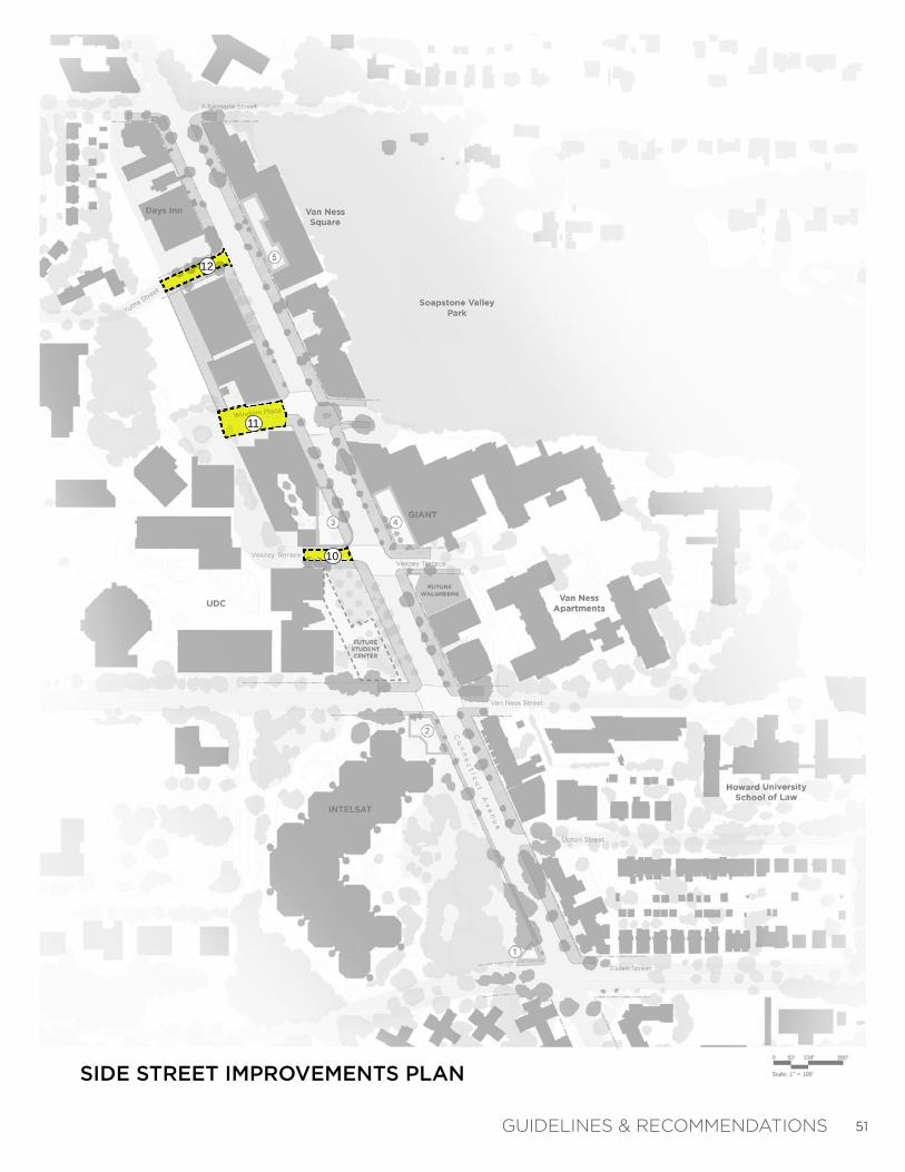
51
SIDE STREET IMPROVEMENTS PLAN
DATIONSGUIDELINES & RECOMMEN
10
11
12
52
EXISTING VIEW: VEAZEY TERRACE LOOKING NORTH
SIDE STREET IMPROVEMENTS: VEAZEY TERRACE
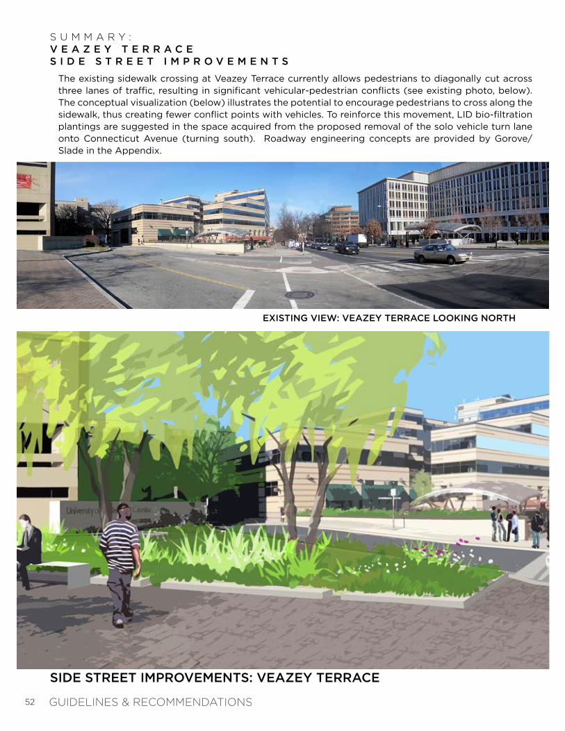
S U M M A R Y :V E A Z E Y T E R R A C E S I D E S T R E E T I M P R O V E M E N T S
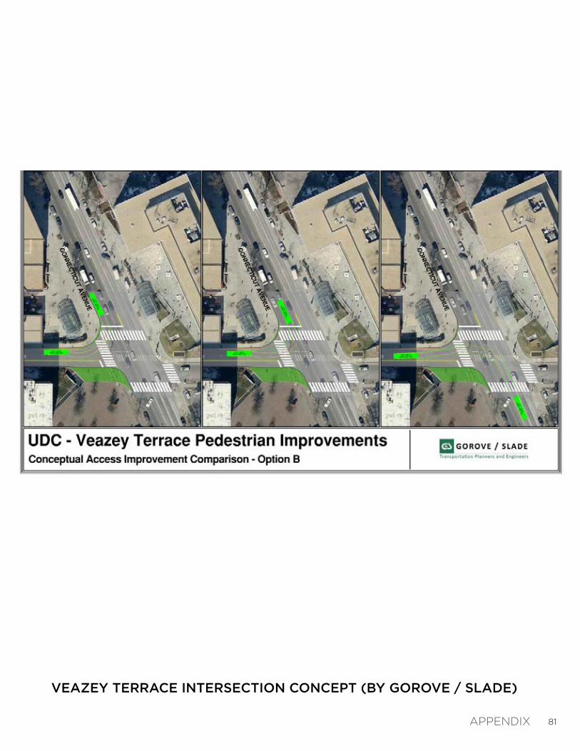
The existing sidewalk crossing at Veazey Terrace currently allows pedestrians to diagonally cut across three lanes of traffic, resulting in significant vehicular-pedestrian conflicts (see existing photo, below). The conceptual visualization (below) illustrates the potential to encourage pedestrians to cross along the sidewalk, thus creating fewer conflict points with vehicles. To reinforce this movement, LID bio-filtration plantings are suggested in the space acquired from the proposed removal of the solo vehicle turn lane onto Connecticut Avenue (turning south). Roadway engineering concepts are provided by Gorove/Slade in the Appendix.
GUIDELINES & RECOMMENDATIONS

53
CONCEPTUAL VIEW: VEAZEY TERRACE LOOKING NORTH
VEAZEY TERRACE PLAN ENLARGEMENT
GUIDELINES & RECOMMENDATIONS
54
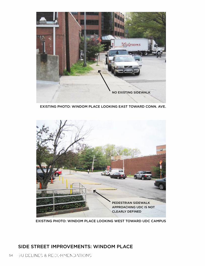
SIDE STREET IMPROVEMENTS: WINDOM PLACE
NO EXISTING SIDEWALK
PEDESTRIAN SIDEWALK
APPROACHING UDC IS NOT
CLEARLY DEFINED
EXISTING PHOTO: WINDOM PLACE LOOKING EAST TOWARD CONN. AVE.
EXISTING PHOTO: WINDOM PLACE LOOKING WEST TOWARD UDC CAMPUS

55
SIDE STREET IMPROVEMENTS: WINDOM PLACE
WINDOM PLACE PLAN ENLARGEMENT
S U M M A R Y :W I N D O M P L A C E S I D E S T R E E T I M P R O V E M E N T S
Windom Place has been designated as the “secondary pedestrian entry” to the University of the District of Columbia’s campus (UDC Campus Development Plan 2011-2020, Exhibit 3.9.b). The existing photos (left) illustrate the streetscape issues observed along Windom Place. The proposed improvement plan (bottom) shows a consolidation of the streetscape, while still maintaining existing parallel parking and clear access for loading / unloading at the south building. Items added to the streetscape include: 1) LID bio-filtration planting with street trees along the parallel parking areas; and 2) demarcation of the pedestrian side-walk along the loading area.
GUIDELINES & RECOMMENDATIONS

56
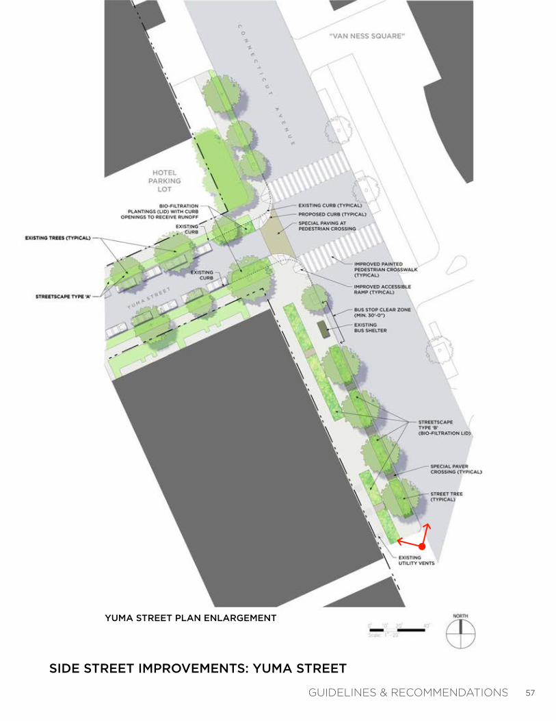
SIDE STREET IMPROVEMENTS: YUMA STREET
EXISTING PHOTO: LOOKING NORTH TOWARD YUMA STREET
REPLACE RAISED PLANTERS
WITH LID STORMWATER
INFILTRATION BASIN
(SLIGHTLY DEPRESSED)
SEVERAL EXISTING
CATCH BASINS ARE
LOCATED ALONG THIS
CURB LINE -- IDEAL
LOCATION TO COLLECT
AND FILTER
STORMWATER RUNOFF
S U M M A R Y :Y U M A S T R E E TS I D E S T R E E T I M P R O V E M E N T S
Based on the analysis provided on the Topography + Hydrology Map (see page 17), the majority of stormwater runoff collects in several curb inlets along Con-necticut Avenue in the area adjacent to the Yuma Street intersection (see exist-ing photo below). The proposed plan enlargement (right) capitalizes on this fact, and recommends applying LID Streetscape Type 2 within this area (see page 46). This LID bio-filtration approach would collect runoff and filter it be-fore it enters into the several stormwater inlets currently located in this area.
Near the Yuma Street pedestrian crossing, adding a bumpout at the end of the existing parallel parking would offer another opportunity to collect and filter rainwater before emptying into the stream valley.
57
SIDE STREET IMPROVEMENTS: YUMA STREET
YUMA STREET PLAN ENLARGEMENT
GUIDELINES & RECOMMENDATIONSGUIDELINES & RECOMMENDATION
58
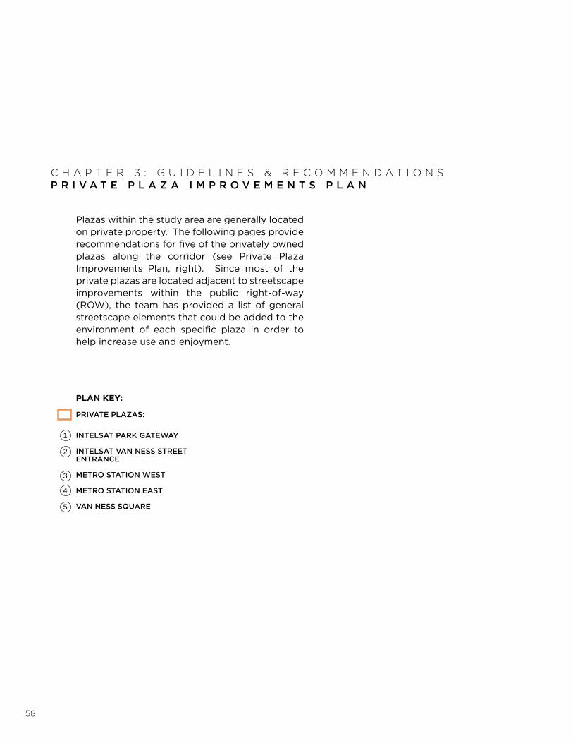
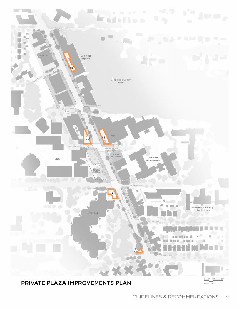
Plazas within the study area are generally located on private property. The following pages provide recommendations for five of the privately owned plazas along the corridor (see Private Plaza Improvements Plan, right). Since most of the private plazas are located adjacent to streetscape improvements within the public right-of-way (ROW), the team has provided a list of general streetscape elements that could be added to the environment of each specific plaza in order to help increase use and enjoyment.
C H A P T E R 3 : G U I D E L I N E S & R E C O M M E N D A T I O N SP R I V A T E P L A Z A I M P R O V E M E N T S P L A N
2
1
3
4
5
PRIVATE PLAZAS:
INTELSAT PARK GATEWAY
INTELSAT VAN NESS STREET ENTRANCE
METRO STATION WEST
METRO STATION EAST
VAN NESS SQUARE
PLAN KEY:
59
PRIVATE PLAZA IMPROVEMENTS PLAN
DATIONSGUIDELINES & RECOMMEN
1
2
43
5

60
SCULPTURE
PLANT FEATURES
PRIVATE PLAZA #1: INTELSAT PARK GATEWAYOPPORTUNITIES FOR IMPROVEMENT
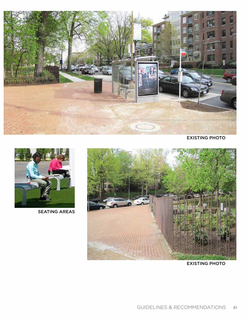
S U M M A R Y :P R I V A T E P L A Z A # 1 I M P R O V E M E N T S
The existing photo of Private Plaza #1 shows an abun-dance of paving near the entrance to Intelsat’s corpo-rate campus (above, bottom right). Due to the plazas location at the southern point of the study area, this space has the potential to become a stronger gateway into the Van Ness-UDC corridor. The addition of sculp-ture, seating, or plant features could help to enliven this space.
GUIDELINES & RECOMMENDATIONS
61
EXISTING PHOTO
EXISTING PHOTO
SEATING AREAS
GUIDELINES & RECOMMENDATIONS

62
PRIVATE PLAZA #2: INTELSAT VAN NESS STREET ENTRANCE OPPORTUNITIES FOR IMPROVEMENT
SCULPTURE
S U M M A R Y :P R I V A T E P L A Z A # 2 I M P R O V E M E N T S
The existing photo of Private Plaza #2 also shows an abundance of paving near the northeast entrance to Intelsat (above, bottom right). This plaza has potential to become a more active space, with its close proximi-ty to UDC and the busy pedestrian crossing at Van Ness Street. The addition of temporary food vendors and outdoor tables for lunch meetings could help to invigorate this street corner. Permanent sculpture and seating could help to soften this generously paved pla-za.
GUIDELINES & RECOMMENDATIONS

63
EXISTING PHOTO: LOOKING NORTH
EXISTING PHOTO: PLAZA ENTRANCE
TEMPORARY FOOD VENDORS OR FARMER’S MARKETS
OUTDOOR DINING
SEATING AREAS
GUIDELINES & RECOMMENDATIONS
64SEATING AREAS
CONSOLIDATED NEWSPAPER STAND
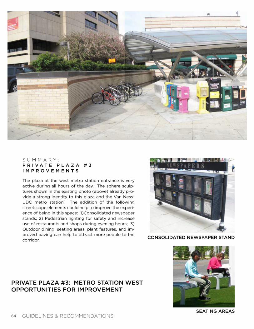
PRIVATE PLAZA #3: METRO STATION WESTOPPORTUNITIES FOR IMPROVEMENT
S U M M A R Y :P R I V A T E P L A Z A # 3 I M P R O V E M E N T S
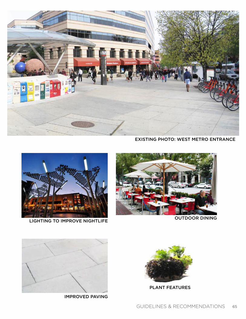
The plaza at the west metro station entrance is very active during all hours of the day. The sphere sculp-tures shown in the existing photo (above) already pro-vide a strong identity to this plaza and the Van Ness-UDC metro station. The addition of the following streetscape elements could help to improve the experi-ence of being in this space: 1)Consolidated newspaper stands; 2) Pedestrian lighting for safety and increase use of restaurants and shops during evening hours; 3)Outdoor dining, seating areas, plant features, and im-proved paving can help to attract more people to the corridor.
GUIDELINES & RECOMMENDATIONS
65
EXISTING PHOTO: WEST METRO ENTRANCE
OUTDOOR DININGLIGHTING TO IMPROVE NIGHTLIFE
PLANT FEATURES
IMPROVED PAVING
GUIDELINES & RECOMMENDATIONS

66
OUTDOOR DINING
FLEXIBLE SEATING
PRIVATE PLAZA #4: METRO STATION EASTOPPORTUNITIES FOR IMPROVEMENT
S U M M A R Y :P R I V A T E P L A Z A # 4 I M P R O V E M E N T S
The plaza just outside Giant grocery store offers a great space in which to gather. The addition of the following streetscape elements could help to improve the experi-ence of being in this space: 1) Flexible seating that al-lows residents to move into the shade or gather to-gether for lunch; 2) Outdoor dining areas; 3) Consoli-dated newspaper stand near the metro entrance; and 4) Shade structures (temporary or permanent) to help protect users of the space during the Summer.
GUIDELINES & RECOMMENDATIONS

67
EXISTING PHOTO: AT EAST METRO ENTRANCE
EXISTING PHOTO: LOOKING NORTH
CONSOLIDATED NEWSPAPER STAND
SHADE STRUCTURES

68
SEATING AREAS
TEMPORARY FOOD VENDORS OR FARMER’S MARKETS
PRIVATE PLAZA #5: VAN NESS SQUAREOPPORTUNITIES FOR IMPROVEMENT
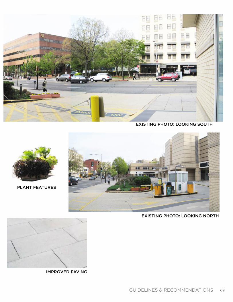
S U M M A R Y :P R I V A T E P L A Z A # 5 I M P R O V E M E N T S
The final private plaza within the study area is located at the Van Ness Square retail center. Although this pla-za lacks an actual pedestrian plaza space, there are certain elements that could help to attract more retail shoppers, including: 1) seating areas and plant features located along the store fronts; 2) improved paving ma-terials that provide a pedestrian feel; and 3) temporary food vendors or farmer’s markets, which could help to highlight this retail center location.
GUIDELINES & RECOMMENDATIONS
69
EXISTING PHOTO: LOOKING SOUTH
EXISTING PHOTO: LOOKING NORTH
PLANT FEATURES
IMPROVED PAVING
GUIDELINES & RECOMMENDATIONS

70
The Corridor Improvements Summary Plan (right) consolidates all recommended improvements to the Streetscape (within the Right-of-Way), Private Plazas, and Side Streets as described on previous pages.
The goal of this study has been to define concepts and strategies for improving the streetscape environment along this section of Connecticut Avenue NW through the application of LID techniques and principles. This study does not provide detailed design or construction documentation.
During the next phase of design and implementation, DDOT will facilitate the development of technical design and engineering drawings that adapt to the various physical conditions along the corridor. DDOT is in the process of developing LID Streetscape standards for paving and stormwater management within public space. Until these standards are fully adopted by the District of Columbia, the incorporation of LID techniques into streetscape design will need to be considered and reviewed individually by DDOT staff.
C H A P T E R 3 : G U I D E L I N E S & R E C O M M E N D A T I O N SC O R R I D O R I M P R O V E M E N T S S U M M A R Y P L A N
GUIDELINES & RECOMMENDATIONS
2
1
3
4
5
10
11
12
PRIVATE PLAZA IMPROVEMENTS(SEE PLAZA IMPROVEMENT BOARDS)
INTELSAT PARK GATEWAY
INTELSAT VAN NESS STREET ENTRANCE
METRO STATION WEST
METRO STATION EAST
VAN NESS SQUARE
PLAN KEY:
PROPOSED UDC STUDENT CENTER BUILDING (BY OTHERS)
PROPOSED UDC STUDENT CENTER PLAZA (BY OTHERS)
CONNECTICUT AVENUE PEDESTRIAN CROSSING IMPROVEMENTS
POTENTIAL ‘GREEN’ ALLEY
SIDE STREET IMPROVEMENTS(SEE STREETSCAPE ENLARGEMENTS)
VEAZEY TERRACE
WINDOM PLACE
YUMA STREET
PUBLIC RIGHT-OF-WAY (ROW)
LID STREETSCAPE IMPROVEMENTS(WITHIN THE RIGHT-OF-WAY)
LID STREETSCAPE TYPE 1: TREE PIT PLANTING EXTENSIONS ( previous map)
LID STREETSCAPE TYPE 2: BIO-INFILTRATION PLANTING (LID) ( previous map)
LID STREETSCAPE TYPE 3: IMPROVED LOW PLANTINGS (IN TREE STRIP) ( previous map)
LID STREETSCAPE TYPE 3: IMPROVED LOW PLANTINGS - RESIDENTIAL ( previous map)
EXISTING TREES TO PRESERVE

71
CORRIDOR IMPROVEMENTS SUMMARY PLAN
DATIONSGUIDELINES & RECOMMEN

72
73
A P P E N D I X

74
C O M M E N T S F R O M S T A K E H O L D E R K I C K - O F F M E E T I N G # 1 : F E B R U A R Y 8 , 2 0 1 1
APPENDIX
75APPENDIX

76
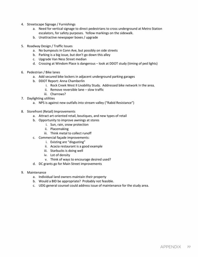
C O M M E N T S F R O M C H A R R E T T E M E E T I N G # 2 : M A R C H 1 4 , 2 0 1 1
AAPPENDIX
77APPENDIX

78
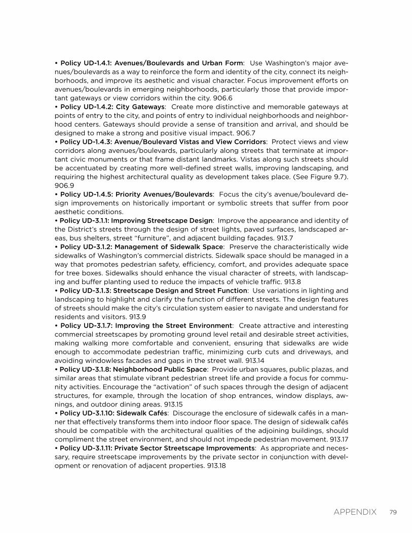
2 0 1 0 C O M P R E H E N S I V E P L A N :G O A L S , P O L I C I E S , A N D A C T I O N S
• Policy E-1.1.1: Street Tree Planting and Maintenance: Plant and maintain street trees in all parts of the city, particularly in areas where existing tree cover has been reduced over the last 30 years. Recognize the importance of trees in providing shade, reducing energy costs, improving air and water quality, providing urban habitat, absorbing noise, and cre-ating economic and aesthetic value in the District’s neighborhoods. 603.4• Policy E-1.1.3: Landscaping: Encourage the use of landscaping to beautify the city, en-hance streets and public spaces, reduce storm water runoff, and create a stronger sense of character and identity. 603.7• Policy E-3.1.1: Maximizing Permeable Surfaces: Encourage the use of permeable mate-rials for parking lots, driveways, walkways, and other paved surfaces as a way to absorb storm water and reduce urban runoff. 613.2• Policy E-1.3.2: Grading and Vegetation Removal: Encourage the retention of natural vegetation and topography on new development sites. Grading of hillside sites should be minimized and graded slopes should be quickly re-vegetated for stabilization.605.3• Policy LU-2.4.10: Use of Public Space within Commercial Centers: Carefully manage the use of sidewalks and other public spaces within commercial districts to avoid pedes-trian obstructions and to provide an attractive and accessible environment for shoppers. Where feasible, the development of outdoor sidewalks cafés, flower stands, and similar uses which “animate” the street should be encouraged. Conversely, the enclosure of out-door sidewalk space with permanent structures should generally be discouraged. 312.14• Policy T-2.3.1: Better Integration of Bicycle and Pedestrian Planning: Integrate bicycle and pedestrian planning and safety considerations more fully into the planning and de-sign of District roads, transit facilities, public buildings, and parks. 409.8• Policy T-2.4.1: Pedestrian Network: Develop, maintain, and improve pedestrian facili-ties. Improve the city’s sidewalk system to form a network that links residents across the city. 410.5• Policy T-2.4.2: Pedestrian Safety: Improve safety and security at key pedestrian nodes throughout the city. Use a variety of techniques to improve pedestrian safety, including textured or clearly marked and raised pedestrian crossings, pedestrian-actuated signal push buttons, and pedestrian count-down signals. 410.6• Policy T-2.4.3: Traffic Calming: Continue to address traffic-related safety issues through carefully considered traffic calming measures. 410.7• Policy T-2.4.4: Sidewalk Obstructions: Locate sidewalk cafés and other intrusions into the sidewalk so that they do not present impediments to safe and efficient pedestrian passage. Maintain sidewalk surfaces and elevations so that disabled or elderly pedestri-ans can safely use them. 410.8• Policy UD-1.2.1: Respecting Natural Features in Development: Respect and perpetuate the natural features of Washington’s landscape. In low-density, wooded or hilly areas, new construction should preserve natural features rather than altering them to accomo-date development. Density in such areas should be limited and setbacks should be pro-vided as needed to protect natural features such as streams and wetlands. Where appro-priate, clustering development should be considered as a way to protect natural resources. 904.3
The Comprehensive Plan is a general policy document that provides overall guidance for future planning and development of the city. The first Comprehensive Plan was adopted in 1984 and 1985. The plan is updated periodically, most recently in 2010. The Plan can be found on the DC Office of Planning’s website at www.planning.dc.gov. This section in-cludes policies from the Comprehensive Plan that are relevant to public space.
APPENDIX
79
• Policy UD-1.4.1: Avenues/Boulevards and Urban Form: Use Washington’s major ave-nues/boulevards as a way to reinforce the form and identity of the city, connect its neigh-borhoods, and improve its aesthetic and visual character. Focus improvement efforts on avenues/boulevards in emerging neighborhoods, particularly those that provide impor-tant gateways or view corridors within the city. 906.6• Policy UD-1.4.2: City Gateways: Create more distinctive and memorable gateways at points of entry to the city, and points of entry to individual neighborhoods and neighbor-hood centers. Gateways should provide a sense of transition and arrival, and should be designed to make a strong and positive visual impact. 906.7• Policy UD-1.4.3: Avenue/Boulevard Vistas and View Corridors: Protect views and view corridors along avenues/boulevards, particularly along streets that terminate at impor-tant civic monuments or that frame distant landmarks. Vistas along such streets should be accentuated by creating more well-defined street walls, improving landscaping, and requiring the highest architectural quality as development takes place. (See Figure 9.7). 906.9• Policy UD-1.4.5: Priority Avenues/Boulevards: Focus the city’s avenue/boulevard de-sign improvements on historically important or symbolic streets that suffer from poor aesthetic conditions. • Policy UD-3.1.1: Improving Streetscape Design: Improve the appearance and identity of the District’s streets through the design of street lights, paved surfaces, landscaped ar-eas, bus shelters, street “furniture”, and adjacent building façades. 913.7• Policy UD-3.1.2: Management of Sidewalk Space: Preserve the characteristically wide sidewalks of Washington’s commercial districts. Sidewalk space should be managed in a way that promotes pedestrian safety, efficiency, comfort, and provides adequate space for tree boxes. Sidewalks should enhance the visual character of streets, with landscap-ing and buffer planting used to reduce the impacts of vehicle traffic. 913.8• Policy UD-3.1.3: Streetscape Design and Street Function: Use variations in lighting and landscaping to highlight and clarify the function of different streets. The design features of streets should make the city’s circulation system easier to navigate and understand for residents and visitors. 913.9• Policy UD-3.1.7: Improving the Street Environment: Create attractive and interesting commercial streetscapes by promoting ground level retail and desirable street activities, making walking more comfortable and convenient, ensuring that sidewalks are wide enough to accommodate pedestrian traffic, minimizing curb cuts and driveways, and avoiding windowless facades and gaps in the street wall. 913.14• Policy UD-3.1.8: Neighborhood Public Space: Provide urban squares, public plazas, and similar areas that stimulate vibrant pedestrian street life and provide a focus for commu-nity activities. Encourage the “activation” of such spaces through the design of adjacent structures, for example, through the location of shop entrances, window displays, aw-nings, and outdoor dining areas. 913.15• Policy UD-3.1.10: Sidewalk Cafés: Discourage the enclosure of sidewalk cafés in a man-ner that effectively transforms them into indoor floor space. The design of sidewalk cafés should be compatible with the architectural qualities of the adjoining buildings, should compliment the street environment, and should not impede pedestrian movement. 913.17• Policy UD-3.1.11: Private Sector Streetscape Improvements: As appropriate and neces-sary, require streetscape improvements by the private sector in conjunction with devel-opment or renovation of adjacent properties. 913.18
APPENDIX

80
EXISTING UTILITY PLAN (PROVIDED BY DDOE)
APPENDIX
81
VEAZEY TERRACE INTERSECTION CONCEPT (BY GOROVE / SLADE)
APPENDIX
82
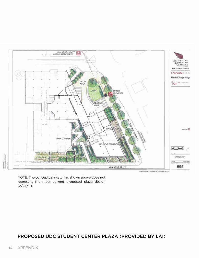
PROPOSED UDC STUDENT CENTER PLAZA (PROVIDED BY LAI)
NOTE: The conceptual sketch as shown above does not represent the most current proposed plaza design (2/24/11).
APPENDIX

83