tree-grass project - nasa€œsavannas in a changing earth system” the nasa terrestrial ecology ....
TRANSCRIPT

1
“Savannas in a Changing Earth System”
The NASA Terrestrial Ecology
Tree-Grass Project
Outline for a Coordinated NASA Field Campaign for Earth Observation and Modeling in Mixed Tree-Grass Ecosystems
Southern Africa Texas
Northern Australia Brazil
Page i
The NASA Terrestrial Ecology Tree-Grass Project
Lead Authors:
Niall P. Hanan
Geographic Information Science Center of Excellence (GIScCE)
South Dakota State University, Brookings, SD 57007
Michael J. Hill
Department of Earth System Science and Policy
University of North Dakota, Grand Forks, ND 58202
Cover Photos: M. Hill (Australia, Texas), M. Bustamante (Brazil), N. Hanan (South Africa)

Page ii
Steering Group:
Steve Archer, University of Arizona, Tucson
Dennis Baldocchi, University of California, Berkeley
Ralph Dubayah, University of Maryland, College Park
Marcy Litvak, University of New Mexico, Albuquerque
Sassan Saatchi, NASA Jet Propulsion Laboratory, Pasadena
Dar Roberts, University of California, Santa Barbara
Savanna Remote Sensing Workshop Keynote Speakers:
Almut Arneth, Lund University, Sweden
Ian Baker, Colorado State University
Damian Barrett, University of Queensland, Australia
Matthias Disney, University College, London, UK
Jelle Ferwerda, University of Twente, Belgium
Steve Higgins, Goethe University of Frankfurt, Germany
Bill Hoffman, North Carolina State University
Lindsay Hutley, Charles Darwin University, Australia
Richard Lucas, University of Wales, Aberystwyth, UK
Steve Prince, University of Maryland, College Park
Robert Scholes, CSIR, Pretoria, South Africa
Additional Contributors & Savanna Remote Sensing Workshop Participants
See Appendix 2(Workshop Participants) and Appendix 5 (Mailing List)

Page iii
Table of Contents
Foreword Summary
1. Introduction 1 1.1 Rationale 1 1.2 Scientific Background – tree-grass systems and earth observation 6 1.3 Motivations for the Tree-Grass activity 10 1.4 Tree-Grass: overarching Science Questions 12
2. Tree-Grass Framework and Science Themes 12 2.1 Tree-Grass Science Themes 13 2.1.1. TG Science Theme 1: Land surface-atmosphere interactions 14 2.1.2. TG Science Theme 2: Global carbon cycle 14 2.1.3. TG Science Theme 3: Water resources 14 2.1.4. TG Science Theme 4: Degradation and shrub encroachment 14 2.1.5. TG Science Theme 5: Tree-grass and savanna goods and services 15 2.2 Tree-Grass Earth Observation Focal Areas 15 2.2.1 EO Focal Area 1: Tree-grass remote sensing 15 2.2.2 EO Focal Area 2: Tree-grass modeling 16 2.2.3 EO Focal Area 3: Data assimilation 18 2.3 Tree-Grass Interdisciplinary Applications: Human Wellbeing & Sustainability 18
3. Tree-Grass Research Strategy 19 3.1 Overall Approach 19 3.2. Candidate Study Sites and Regions 20 3.3 Phase 1: Tree-Grass EO Synthesis and Evaluation 23 3.3.1 Phase 1 strategy 23 3.3.2 Phase 1 science components 24 3.4 Phase 2: Tree-Grass Field Campaigns 25 3.4.1 Phase 2 strategy 25 3.4.2 Phase 2 science components 26 3.5 Phase 3: Tree-Grass Applications 28 3.5.1 Phase 3 strategy 28
4. Tree-Grass Education and Outreach 29 4.1. Graduate Research Fellowship Program (GRFP) 29 4.2. Earth System Science Summer Schools (E4S) 30 4.3 Technology Transfer and Adoption Program (TTAP) 31
Page iv
5. Tree-Grass Organization and Management 31 5.1 Scientific Leadership 31 5.2 Project Management 32 5.3 Partnerships and Collaborations 34 5.4 Field Operations 36 5.5 Data Management and Sharing 36
6. Summary of National and International Research Community Interest in Tree-Grass
38
6.1 Tree-Grass science community interest 38 6.2 Relevance to US Federal and State Agencies 38 6.3 Relevance to International Global Change and Sustainability Research 39
7. Resource Needed for Tree-Grass 40 7.1 Field Infrastructure 40 7.2 Sub-orbital platforms and sensors 41 7.3 Satellite data access and purchase 42 7.4 Approximate Total Cost Estimates for Tree-Grass 43
8. References 44
Appendices 48 1. Critical Requirements for Earth Observation in Tree-Grass Systems 2. Savanna Remote Sensing Workshop Participants 3. Field sites relevant to Tree-Grass 4. New and next generation satellite missions relevant to Tree-Grass 5. SRS Mailing List

Page v
Foreword In 2009 the NASA Terrestrial Ecology Program supported a “Scoping Study” entitled “Challenges and Opportunities in Remote Sensing of Global Savannas: A Scoping Study for a New TE Field Campaign”. The initial intent of this project was to develop the case for renewed focus on savannas via a major new field research program in the tradition of the FIFE, BOREAS and LBA series. The Scoping Study made possible a thematic workshop (the “Savanna Remote Sensing Workshop” in Fort Collins, Colorado, March 2010) that gathered some 50 experts from around the world, and an extended consultative process with close to 200 participants, that culminated in the drafting of this White Paper.
Several key realizations emerged during this process that modified our directions, whilst reinforcing our conviction that savannas, and other mixed woody-herbaceous systems, should be the focus of a new TE field program; these realizations now permeate and motivate the recommendations in this white paper.
Firstly, that savanna ecosystems, as generally defined to include woody-herbaceous systems in drought-seasonal areas, are a subset of more widely distributed ‘tree-grass’ vegetation communities worldwide, representing (by our estimates) some 35% of the terrestrial land surface.
Second, that these tree-grass systems, although globally diverse in climatic, biotic, and management characteristics, present similar challenges for earth observation (specifically remote sensing and modeling) because of their fundamental structural similarities (i.e. a discontinuous woody canopy over a more or less continuous herbaceous layer) that transcend the aforementioned differences.
Thirdly, that where remote sensing and modeling of terrestrial vegetation has focused on aggregate retrievals (e.g. total LAI or canopy fPAR) for practical reasons, such historical contingencies need not, and should not, constrain future pathways: should we continue to ignore the horizontal and vertical heterogeneity of vegetated landscapes when our remote sensing and modeling technologies can probably do better?
Fourthly that, while recent TE field projects have greatly advanced earth observation and modeling of vegetation processes, a renewed focus on remote sensing science directed towards the partitioning of woody and herbaceous canopies, could pave the way towards greater structural and functional realism in remote sensing retrievals and associated earth system models.
And finally, that advances in remote sensing and modeling of woody-herbaceous mixtures will provide direct benefits for earth observation in all terrestrial systems where vegetation community structures can generally be considered end-members of the woody-herbaceous continuum.

Page vi
Summary In this white paper we develop ideas for a NASA Terrestrial Ecology (TE) field activity that will enhance remote sensing and earth system modeling capabilities in ecosystems characterized by mixtures of woody and herbaceous species (‘tree-grass’ systems). The “Tree-Grass” (TG) project will transform our ability to use satellite data and earth system models to assess the current and future role of tree-grass systems in the earth system, and their future in the face of changing climate, changing land use and human population growth. In so doing we will enhance our ability to manage tree-grass ecosystems for sustainability, food security and human wellbeing.
The overarching TG science questions are:
1) How are climate change and land-use change altering the structure, function and productivity of tree-grass systems at landscape, regional and global scales? (“Global Change Processes”)
2) How will changes in tree-grass structure, function and productivity interact in the earth system and feed-back on the major cycles of carbon, water and nutrients and energy flows? (“Biophysical and Ecological Interactions”)
3) How will global change and biophysical interactions in tree-grass systems impact human wellbeing, food security and sustainability into the future? Conversely, what is the potential for global change mitigation, and can human populations in tree-grass regions benefit from this potential? (“Goods and Services”)
The coordinated TG research activity will focus on a) remote sensing science to realize the potential of airborne and satellite assets to retrieve key parameters describing tree-grass ecosystem state and function; b) development and testing of earth system modeling capabilities suited to the structural and functional characteristics of savannas; c) model-data synthesis (data-assimilation) to integrate new remote sensing and modeling capabilities, and d) extensive education and outreach programs.
TG field activities will adopt a hierarchical sampling approach, with locally intensive field components in North America, linked to globally distributed activities deployed in partnership with international collaborators. We propose a phased implementation for TG, with Phase 1 (“Synthesis and Evaluation”) concentrating on synthesis and evaluation of existing remote sensing and modeling capabilities in tree-grass systems, Phase 2 (“Field Campaigns’) implementing major field, remote sensing and model development activities, and Phase 3 (‘Applications’) focusing on regional-global scale applications relevant to understanding and management of tree-grass systems.
TG seeks to revolutionize earth observation science through improved consideration of woody and herbaceous functional groups in remote sensing and modeling of terrestrial ecosystems. The TG program will entrain and inspire the next generation of earth system scientists and enhance public appreciation of the crucial role NASA remote sensing technologies can play in understanding and managing the earth system.

Page 1
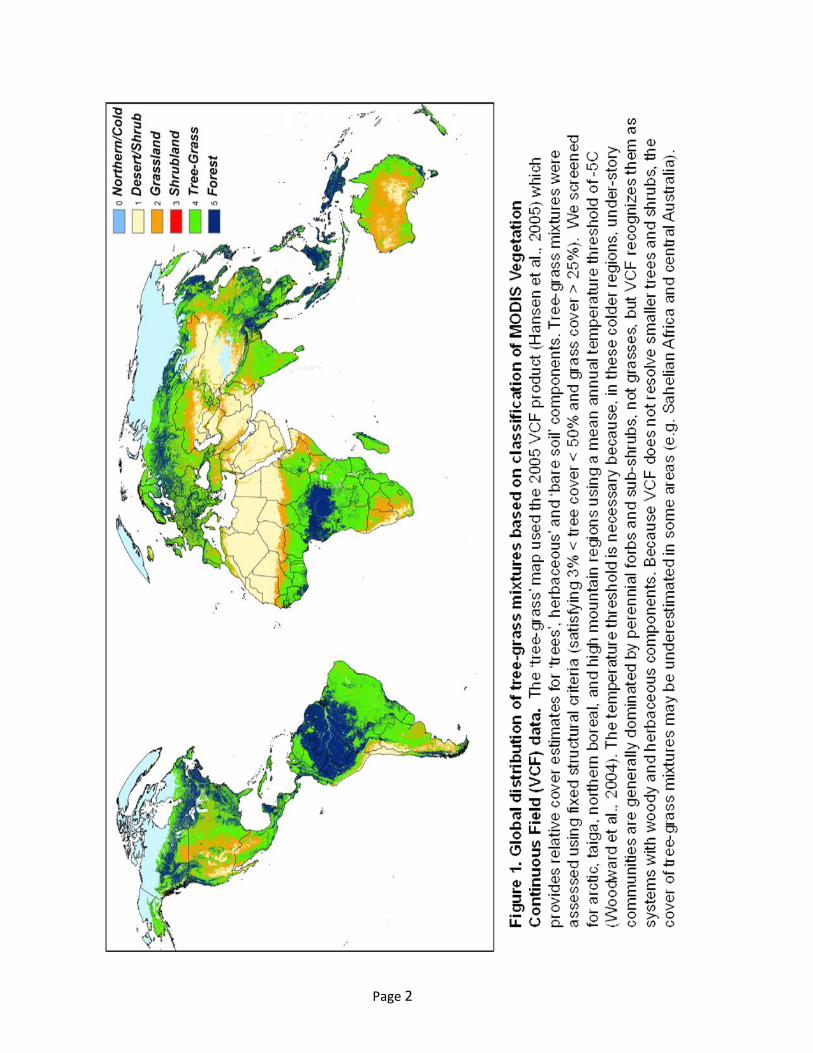
1. Introduction 1.1. Rationale Mixed tree-grass and shrub-grass vegetation associations are one of the most spatially extensive and widely distributed forms of terrestrial vegetation on earth. These “savanna” ecosystems (where, for the purposes of this white paper, we use ‘savanna’ and ‘tree-grass’ interchangeably to denote any and all mixed woody-herbaceous communities) constitute significant fractions of all continents except Antarctica, and they are found in tropical, subtropical and temperate bioclimatic regions (Figure 1, Table 1). While global tree-grass systems are diverse in their phylogeny, physiology and plant morphology, they share the key structural characteristic of woody plants distributed in the landscape at densities low enough to allow significant growth of herbaceous plants (mostly grasses) underneath and between them (Bourliere and Hadley 1970; Walker et al. 1981; Sarmiento 1984; Mistry 2000; Hill et al. 2011; Lehmann et al. 2011).
An analysis highlighting tree-grass mixtures derived from the MODIS Vegetation Continuous Fields product (VCF; Hansen et al. 2005) provides estimates of the global importance of tree-grass systems (Figure 1, Table 1). While VCF calibration procedures omit smaller trees (< 5m) and shrubs, the VCF product provides a globally consistent and objective database (albeit potentially underestimating woody cover in some areas because of the shrub omission). Table 1 also shows area estimates from the MODIS Land Cover Land Use product (MOD12; Friedl et al. 2002) representing how ‘savannas’ are traditionally mapped. Such more traditional savanna definitions significantly underestimate the extent of mixed woody-herbaceous systems assessed from a more inclusive ‘tree-grass’ perspective. In part this occurs because tree-grass mixtures often arise through human actions reducing woody biomass in dense woodlands and forests or, in some areas, favoring tree and shrub establishment in open grasslands. Since many, perhaps most, biome-mapping approaches are strongly rooted in concepts of ‘potential vegetation’ they tend to ignore the anthropogenically modified landscapes in defining the biome, where a structural approach (i.e. VCF) does not.
While the estimates of distribution and surface area of tree-grass mixtures in Figure 1 and Table 1 are preliminary, they support a growing realization in the earth observation and modeling communities that tree-grass mixtures are globally far more significant than generally appreciated. For example, many woodlands, including huge areas of temperate woodland and dry deciduous woodland in the tropics, are effectively “managed as savannas” (Hanan and Lehmann 2011), with suppression of trees through fire and wood harvest,
Tree-grass systems are globally widespread
Often under-appreciated in global maps
Page 2

Page 3
increased grass production and livestock grazing (Figure 2). Furthermore, although industrial-scale arable agriculture tends to suppress trees over large areas, less intensive, subsistence agriculture tends to reduce, but not eliminate, tree-cover. Indeed, less intensive agricultural systems often support persistence of trees for shade, fruit, fuel-wood and other uses, in a patch-work of cleared fields and re-growing fallow. In many parts of the world, therefore, agricultural and pastoral activities promote tree-grass mixtures at patch and landscape scales. As shown using the example in Table 1, more traditional land cover classifications rarely recognize these derived tree-grass mixtures, despite the important differences in structure and function of tree-grass mixtures relative to systems with less structural diversity.
Table 1. Global tree-grass areas (km2 and % of totals) estimated using structural criteria (tree and grass cover from VCF) and a biome distribution map (MODIS-IGBP)
Continent Total Land Area
Tree-Grass Area (VCF)
% Tree-Grass (VCF)
% Tree-Grass (MODIS-IGBP)
Africa 29.7 x 10⁶ 11.1 x 10⁶ 37.3 30.7
Australia 07.8 x 10⁶ 02.3 x 10⁶ 29.2 17.5
Eurasia 54.9 x 10⁶ 20.2 x 10⁶ 36.9 8.3
North America 23.3 x 10⁶ 06.0 x 10⁶ 25.9 10.8
South America 17.5 x 10⁶ 08.2 x 10⁶ 46.8 22.8
Global Land Surface 133.2 x 10⁶ 47.8 x 10⁶ 35.9 16.3
Notes: The MODIS Vegetation Continuous Fields dataset (VCF; MOD44B; Hansen et al., 2005) provides ‘structurally-based’ estimates, with tree-grass mixtures defined when 3% < tree cover < 50% and grass cover > 25%. The MODIS-IGBP area assessment is based on the ‘savanna’ classes of the MODIS-Land Cover Land Use Classification (MOD12C1; Friedl et al. 2002).
Global tree-grass and savanna regions are vital for livestock production, with global annual meat and milk production values exceeding $1.4 trillion (Thornton 2010). In less developed regions grazing systems directly support the livelihoods of more than 600 million poor subsistence pastoralists where food security and livelihoods are vulnerable to climate variability, drought, degradation and famine (Millennium Ecosystem Assessment 2005; Reynolds et al. 2007). In the Continental United States, of the 117 million ha of Public Land managed by the Department of the Interior (DOI), more than 60% are mixed woody-herbaceous savannas and shrubland (NLCD, 2001). More than 80% of Bureau of Land Management (a DOI Bureau) lands are in mixed woody-herbaceous systems, with more than 12 million animal unit months (AUM) licensed to graze on US BLM lands alone.
Tree-grass goods and services

Page 4
Figu
re 2
. Six
exa
mpl
es o
f glo
bally
div
erse
tree
-gra
ss v
eget
atio
n as
soci
atio
ns, w
ith re
gion
s typ
ical
ly c
lass
ified
as
“sav
anna
” in
the
uppe
r row
, and
regi
ons t
ypic
ally
not
clas
sifie
d as
sava
nna
in th
e lo
wer
row
: (a)
Sah
el o
f Mal
i, W
est
Afric
a (P
hoto
: F D
embe
le);
(b) N
orth
ern
Terr
itory
sava
nnas
, Aus
tral
ia (P
hoto
: A M
arks
); (c
) Cer
rado
, Bra
zil (
Phot
o: M
Bu
stam
ante
); (d
) Edw
ards
pla
teau
shru
blan
ds, T
exas
(Pho
to: M
J Hill
); (e
) Okl
ahom
a oa
k w
oodl
ands
(Pho
to: J
Bur
ton)
; (f
) Dry
dec
iduo
us w
oodl
ands
of s
outh
ern
Wes
tern
Gha
ts, I
ndia
(Pho
to: J
Rat
nam
).
(d)
(a)
(b)
(c)
(e)
(f)

Page 5
In many areas, tree-grass systems have already been partially or fully converted to agriculture, and land use pressures are likely to intensify in the coming decades, driven by parallel needs for increased food production to feed growing populations and increased agricultural production to underpin economic development. Since tree-grass mixtures are not fully represented in land surface models, their role in the climate system, and feedbacks with the atmosphere, are not well understood. We therefore have little idea what the consequences of wholesale land cover and land use change will be for ecosystem function, earth system interactions and feedbacks on agricultural and pastoral production systems and human livelihoods.
Global wildfire occurrence and pyrogenic emissions into the atmosphere are dominated by savanna fires, which represent 80-90% of burned area and >3.5Tg of dry matter combusted each year. These pyrogenic releases have major implications for atmospheric CO2 source-sink patterns (Randerson et al. 2005; van der Werf and Randerson 2006; Williams et al. 2007). Further, black carbon and trace gases released in savanna fires impact atmospheric radiative transfer, energy dynamics and chemistry (Crutzen and Andreae 1990; Andreae et al. 1996; Scholes et al. 1996; Randerson et al. 2006).
Savannas are also subject to directional changes in the balance between woody and herbaceous cover. At global scales the direction and rates of change, and associated ecosystem impacts, can be variable (Eldridge et al. 2011). The shrub encroachment phenomenon, for example, remains poorly understood but has been attributed to changes in management (grazing and fire suppression) and global change processes (changing temperature and rainfall, and increasing atmospheric CO2 concentrations; Archer et al. 1995; Brown and Archer 1999; Fredrickson et al. 2006). In other areas (e.g. parts of Australia, South and North America), loss of woody plants is associated with invasion of exotic grasses and increasing fire frequency (e.g. Setterfield et al. 2010). Increasing density and cover of trees and shrubs in semi-arid rangelands tends to correlate inversely with capacity for livestock production, and thereby impact livelihoods for both commercial and subsistence cattle farmers. These phenomena are therefore of critical importance for subsistence and commercial management and sustainability of tree-grass systems. They also have profound impacts on land surface-atmosphere interactions, carbon and biogeochemical dynamics (Heisler et al. 2003; Asner and Heidebrecht 2005; Bradley et al. 2006; Knapp et al. 2008).
In stark contrast to the importance of tree-grass systems in earth system processes and human well-being, they represent a gap in Earth Observation capabilities, and a serious challenge for the earth observation and modeling science community. Ecosystems characterized by horizontally and vertically complex tree-grass mixtures, and temporal variability related to drought, seasonality, fire, herbivory and land use change, are inherently difficult to
Shrub encroachment
Earth observation and tree-grass systems
Fire
Land use
Page 6
measure with remote sensing and represent in ecosystem and earth system models (Hill et al. 2011). However, recent and emerging technologies and instrumentation present opportunities to address these challenges and enhance our remote sensing and modeling abilities in the savannas. These opportunities will facilitate improved understanding of how tree-grass systems interact in the earth system, how they impact and will be impacted by global change, and how they can be managed for the sustainability and welfare of human societies.
To realize this potential, a comprehensive and integrated research program is required that couples remote sensing, field measurements and models at multiple scales. Research activities at local and regional scales have begun the work (e.g. Beringer et al. 2011 in Northern Australia, Shugart et al. 2004 in Southern Africa). This white paper proposes a new concentration and expansion of efforts specifically to improve EO capabilities (remote sensing and modeling) in tree-grass systems, via complementary ‘intensive’ activities in North America and ‘distributed’ activities globally. The project aims to transform our ability to use satellite data and earth system models to assess the current and future sustainability of savannas in the face of changing climate, changing land use and human population growth. In so doing we will enhance our ability to manage tree-grass ecosystems for sustainability, food security and economic wellbeing. For this activity we propose the simple, but directly meaningful, title “Tree-Grass” (TG).
1.2. Scientific Background – tree-grass systems & earth observation Our conceptual model for tree-grass interactions in the earth-system, with global change and social-ecological systems, is shown in Figure 3.
On geological time-scales the savannas are a young formation. The rapid global expansion of the savannas occurred only 6-8 million years ago (6-8M BP), following the earlier evolution of C4 grasses 15-35M BP (Sage 2004; Beerling and Osborne 2006). C4 expansion was associated with changing paleo-climate, increasing evidence of fire in the earth system, and the evolution and numerical expansion of large herbivores specialized to grazing (Pagani et al. 1999; Keeley and Rundel 2005). This included evolution of the ancestors of the animals that humans would later domesticate for meat and dairy production. Changes in climate, atmospheric CO2 concentration, fire and herbivory were all associated with savanna expansion, and since the last ice age, humans have promoted savanna expansion and persistence through use of fire, wood harvest and grazing (Bond 2008; Hanan and Lehmann 2011). These factors remain critical in determining the modern-day geographic extent of savannas. However, global change processes (land use change and conversion to agriculture, increasing atmospheric CO2, and changing rainfall patterns) mean that the suite of abiotic, biotic and anthropogenic factors important in savannas is changing. The future
NASA Terrestrial Ecology “Tree-
Grass”

Page 7
function and global distribution of tree-grass systems is therefore highly uncertain (Bond 2008).
Tree-grass systems are significant from many perspectives: as regions that respond rapidly to, and feedback on, climate and climate variability (Charney et al. 1975; Schlesinger et al. 1990; Brovkin et al. 1998; Asner and Heidebrecht 2005; Scott et al. 2006); as areas where land degradation and drought are common (UNEP/ISRIC 1990); as vast stores (actual and potential) of carbon in biomass and soils (Scholes and Hall 1996); as a primary location for livestock and grain production (Kruska et al. 1999; Liu et al. 2008); and a primary location of land use change driven by increasing populations, economic development and globalization (Watson et al. 2000; Houghton and Hackler 2006).
Figure 3: Conceptual diagram for tree-grass and savanna systems, showing drivers of change, ecosystem processes and provision of goods and services (center), interactions between global change, biophysical and social-ecological domains (left), and key science questions for the Tree-Grass activity (right).
Globally, savannas are the most fire prone ecosystems and savanna fires account for 80- 90% of the total global burned area (van der Werf et al. 2003; Mouillot and Field 2005). Estimates suggest that 450-750 million hectares and approximately 3700 Tg of dry matter are burned each year in savanna fires, representing up to 50% of global carbon emissions (Andreae 1991; van der Werf and Randerson 2006). Fires in tree-grass regions also emit a wide range of other chemical species as well as particulate matter, with major implications for atmospheric reducing potential, ozone production, incoming solar radiation and nutrient cycling in terrestrial ecosystems (Crutzen and Andreae 1990).
Fire
Earth System Interactions
Page 8
The seminal papers of Charney and colleagues (Charney et al. 1975; Charney 1975; Charney et al. 1977) postulated that changes in surface albedo caused by grazing and vegetation degradation in semi-arid grazing lands can impact regional climate by altering precipitation regimes, initiating a positive feedback and increasing degradation. Since then, drought and famine in Africa, in particular, has caused great hardship and many consider the Sahel of Africa as the primary location, worldwide, where desertification, overgrazing and global climate change, present serious, and on-going, environmental problems. However, although many empirical and model based studies have examined Charney’s hypothesis over the last four decades (Phillips 1993; Nicholson et al. 1998; Asner and Heidebrecht 2005; Giannini et al. 2010) relatively few have demonstrated that local land surface-climate feedbacks have, in reality, been sufficient to impact the global scale processes that generate rainfall variability (see e.g. McAlpine et al. 2007). Indeed, parallel recovery of both rainfall and vegetation in the African Sahel since the droughts of the 1970’s and 1980’s suggests that this area, at least, is not locked in a downward spiral as originally conceived by Charney (Herrmann and Hutchinson 2005; Olsson et al. 2005; Giannini et al. 2010).
The susceptibility and sensitivity of savannas to drought and degradation notwithstanding, these regions also play a pivotal role in regional and global food production and food security. In particular, both temperate and tropical savanna regions are important for protein-rich cereal and meat production which, in both more arid and more humid regions, is often limited by water or nutrient availability, pests and diseases. Thus tree-grass regions are extensively used for grazing and agriculture. In many less developed countries tree-grass systems are also important as sources of fuel-wood and charcoal for domestic consumption.
Given the global importance of tree-grass formations it is notable that many, perhaps most, developments in earth observation (EO) systems, and associated earth system modeling, over the past 40 years have been so poorly adapted to the key structural and functional characteristics of savannas. Rarely indeed, do existing EO systems even attempt to separate tree and grass components, and this omission significantly increases uncertainty and potential for bias in assessments of energy, carbon, water and biogeochemical dynamics (Bégué et al. 1996; Hill and Hanan 2011). The failings of satellite remote sensing and models in savanna systems arise in part because of geographical bias towards the economic centers, forests, woodlands, farms and grasslands, of the temperate latitudes. But also reflects the considerable challenge involved in remote assessment of vegetation structure and dynamics in systems characterized by distinct woody and herbaceous functional groups (Table 2).
The separation of trees and grasses in remote measurement of vegetation is a significant challenge, but an even bigger opportunity, for EO systems already
Desertification feed-backs
Food security
Tree-Grass Challenge

Page 9
Table 2: Challenges & Opportunities for Earth Observation in Tree-Grass Regions
Challenges for EO in Tree-Grass Systems Major Scientific Opportunities
1. Remote Sensing (RS)
Remote Sensing (RS) of land surface properties is difficult in horizontally and vertically complex/heterogeneous canopies
Improving sensor spatial/spectral characteristics, new optical, radar and lidar data should improve our ability to resolve & retrieve vertical and horizontal structure
RS of canopy biophysical variables generally ignores the defining feature of tree-grass systems: that they are composed of separate woody and herbaceous layers
New RS technologies and synergies among sensor types, present opportunities to develop savanna-relevant retrieval techniques for tree-grass structure, biophysical and phenological properties
Methods for remote sensing of biomass and carbon stocks are only recently emerging for forests and not well adapted to low cover and stature savannas
Emerging techniques using optical, radar and lidar to quantify vegetation structure and biomass can be refined and improved for tree-grass systems
RS techniques for canopy physiological and biogeochemical properties and functional rates (fluxes) rarely resolve woody and herbaceous layers
Next generation sensors (hyperspectral, optical, thermal), in synergy with improved structural retrievals, provide opportunities for separation of physiological & biogeochemical properties and functional rates
The central role of disturbance in tree-grass systems (drought, fire, grazing and browsing, wood harvest and agricultural clearance) is difficult to characterize with RS
New and next-generation satellite remote sensing data will provide opportunities for better assessment of soil moisture, fire extent, intensity and emissions, and local changes in vegetation structure related to extraction and conversion
2. Earth System Models and Model-Data Assimilation (MDA)
Regional & global biophysical/biogeochemical models mostly assume structural homogeneity, with little consideration of vertical & horizontal heterogeneity, mix of functional/physiological types, typical of savannas
Models suited to tree-grass systems are available & can be developed for global applications; improved RS will provide boundary conditions and validation for savanna-appropriate biophysical & biogeochemical models
Dynamic global vegetation models resolve and simulate population dynamics of different plant functional types, but remote sensing retrievals to date have not provided information suited to DGVM validation or optimization
Improved remote sensing retrievals will provide data with which such DGVM models can be parameterized and validated
Despite decades of speculation (since Charney), the role of savannas & tree-grass systems in regional and global climate and biogeochemical cycles, & earth system sensitivity to savanna change, is poorly quantified
Combined field studies & model development provide opportunities for improved modeling of aerodynamic, energy & water balance in heterogeneous tree-grass systems, at local to global scales
Relatively few RS data are routinely used by the land surface modeling community (e.g. global climate and biogeochemistry models), and those that are used are adopted in relatively simple modes for a priori parameterization or post-hoc comparison and validation
Increasing quality and relevance of RS and modeling capabilities, and developing methodologies for data assimilation, provide opportunities for an expanded role for remote sensing in earth system models, closer model-data integration and improved simulations
Tree-grass systems are inherently ‘human’ systems where agriculture, grazing, wood harvest and fire management are key drivers of ecosystem processes and land surface-atmosphere interactions, and where ecosystems impact directly human wellbeing and socio-economics
Modeling frameworks for coupled ‘social-ecological systems’ are evolving, providing new opportunities to couple biophysical and biogeochemical models to social- ecological and agent-based models of human management and decision making processes

Page 10
available or soon to be deployed and available for regional-to-global scale applications (Table 2). Current and future generation satellite missions (planned by NASA and partner agencies internationally) include significantly improved spectral and spatial resolution optical sensors, alongside new and improved thermal, radar and lidar instruments. These sensors, on their own or in combination, offer much improved capabilities for the characterization, separation and quantification of tree-grass systems. While uncertainties remain in the precise suite of future satellite resources, much can be achieved with existing resources. Furthermore, cutting edge remote sensing research using ground, aircraft and satellite sensors, demonstrating the power of systems already deployed and synergies with and between emerging technologies can and should continue to lay the foundations for future satellite missions. Improved measurements of savannas worldwide will contribute immensely to our ability to diagnose the status and dynamics of the major biogeochemical cycles of carbon, water, and nutrients, and ecosystem energy flows; contribute to fundamental understanding of the ecology of the earth system; and improve options for sustainable management as savannas are exposed to increasing climatic and anthropogenic stress.
In this white paper we develop ideas for a NASA Terrestrial Ecology Program (TE) field activity that will enhance remote sensing and earth system modeling capabilities for tree-grass systems. Our plan breaks the mold of previous TE field campaigns in proposing a hierarchical sampling methodology, with locally intensive field components in North America, linked with globally distributed activities deployed in partnership with international collaborators. The coordinated activity will focus on 1) remote sensing science to realize the potential of new airborne and satellite assets to retrieve key parameters describing tree-grass ecosystem state and function; 2) development and testing of earth system modeling capabilities suited to the structural and functional characteristics of savannas; 3) model-data synthesis (data-assimilation) to integrate new remote sensing and modeling capabilities, and 4) extensive educational and outreach programs to entrain and inspire the next generation of earth system scientists and enhance public appreciation of the crucial role NASA remote sensing technologies can play in understanding and managing the earth system.
1.3. Motivations for the Tree-Grass activity
Why tree-grass and savanna systems?
Given that savannas are sensitive to climate change and centers of land-use change: global savannas are changing rapidly and will likely be radically transformed in the coming decades.
Tree-Grass White Paper
Tree-Grass Opportunity
Page 11
Because tree-grass systems occupy regionally and globally significant land area and have strong earth system interactions: tree-grass transformation will significantly impact the earth system, via changes in energy flows, hydrological and biogeochemical cycles.
Because tree-grass regions are vital centers of livestock and grain production for more than 600 million often poor and marginalized people: tree-grass change will significantly impact human livelihoods, food security, economic and ecological sustainability.
Since mixed tree-grass and savanna systems are structurally and functionally more complex than other biomes, capabilities developed in the savannas will be transferable to other terrestrial systems.
Why NASA?
NASA research must aim to develop and improve remote sensing methodologies in tree-grass regions to capitalize on the convergence of current and next generation satellite instruments and developing computational opportunities now emerging.
The full engagement of NASA assets, including field, airborne and satellite instrumentation, as well as the NASA research community and partners both nationally and internationally, is the most effective (and perhaps the only) way to advance the necessary research at this crucial moment in time.
NASA research is needed to realize potential synergies in remote sensing and modeling of the tree-grass biome for future transfer to applications and management.
NASA has the reputation and prestige needed to entrain researchers in the USA and internationally in a research program that will redefine earth observation approaches in the savannas and more broadly for terrestrial systems.
Why now?
Existing and planned satellite-borne earth observation instruments have capabilities and synergies far exceeding those with which we have become familiar: renewed concentration on remote sensing science in this field campaign will allow us to realize the potential of these instruments, not only in tree-grass ecosystems but in other (structurally less complex) ecosystems worldwide
Data assimilation methodologies are maturing rapidly, providing new opportunities for the intensive use of improved remote sensing information content: this confluence of opportunities opens the door for the transformation of our ability to monitor and model terrestrial ecosystem
Why NASA?
Why tree-grass?
Why Now?
Page 12
dynamics, biogeochemical cycles and the earth system. Now is the time to make this happen!
Improved remote sensing, modeling and data assimilation capabilities will enable improved science support to those charged with the sustainable management of savannas at local, regional and international scales in this critical time of global change, population growth, globalization and changing economic and political aspirations.
We need to know now how climate and land use changes in savannas and global tree-grass ecosystems will impact the earth system and human wellbeing in the coming decades.
1.4 Tree-Grass: Key Science Questions Overarching science questions driving the Tree-Grass activity are (Figure 3):
1) How are climate change and land-use change altering the structure, function and productivity of tree-grass systems at landscape, regional and global scales? (“Global Change Processes” – blue boxes)
2) How will changes in tree-grass structure, function and productivity interact in the earth system and feed-back on the major cycles of carbon, water and nutrients and energy flows? (“Biophysical and Ecological Interactions” - green boxes)
3) How will global change and biophysical interactions in tree-grass systems impact human wellbeing, food security and sustainability into the future? Conversely, what is the potential of savannas for global change mitigation, and can human populations in savanna regions benefit from this potential? (“Savanna Goods and Services” – orange box)
2. Tree-Grass Framework and Science Themes Tree-Grass (TG) program activities (Figure 4) will be organized to address the Overarching Questions (Section 1.4), via a series of TG Science Themes (Section 2.1) and TG Earth Observation Focal Areas (Section 2.2). Progress in the areas outlined within the Science Themes and associated EO Focal Areas will allow us to develop improved EO applications directed towards improved understanding and management of global tree-grass systems (Tree-Grass Interdisciplinary Applications, Section 2.3). Within the proposed 10-year time-frame, TG will build remote sensing and earth observation capabilities that will contribute meaningful and timely information to enhance human wellbeing, livelihoods and sustainable management of the world’s savanna regions.
Tree-Grass Framework
Tree-Grass Science Questions

Page 13
2.1. Tree-Grass Science Themes The overarching questions posed in Section 1.4 embody some of the most pressing societal problems of the coming century relating to human modification of the earth system and our ability to manage the planet for sustainability and human wellbeing. Within Tree-Grass we identify five interdisciplinary (and overlapping) Science Themes where savanna and tree-grass systems are globally significant (Figure 4). Given the inevitable, but uncertain, template of global change processes in the savannas (see Figure 3), these Science Themes will explore how the continuum of biophysical and ecological Interactions, and social-ecological interactions in the savannas will respond to, and feedback on, the earth system and societal wellbeing.
The primary research questions for the TG Science Themes are detailed below. TG Science Themes are deliberately broad to allow individual and team proposals to the Tree-Grass activity the flexibility to define their own priorities, approach and methodologies, with only minimal coordination and direction from above to ensure program coherence.
Figure 4: The Tree-Grass Science Framework.
Tree-Grass Key Questions“Global Savannas & Global Change? Earth System Interactions? Human Wellbeing?”
Theme 1Land Surface -Atmosphere Interactions
Tree-Grass Interdisciplinary Applications“Enhanced understanding & prediction, improved management, sustainability & human wellbeing”
Theme 2Global
Carbon Cycle
Theme 3Water
Resources
Theme 4Degradation &
shrub encroach.
Theme 5Savanna Goods & Services
Biophysical & Ecological
Social-Ecological
EO-Science Focal AreasRS Science -- Modeling -- Data Assimilation
Tree-Grass Science Themes
Tree-Grass Science Themes

Page 14
2.1.1. TG Science Theme 1: Land surface-atmosphere interactions What is the current role of global tree-grass and savanna systems in the
earth system via energy and mass exchange at the land surface-atmosphere interface?
What role do savannas play in atmospheric chemistry via pyrogenic and trace gas emissions, and in atmospheric radiative transfer and energy balance via dust and aerosol emissions?
How will changes in climate and land use impact the distribution, structure and function of savannas in future decades?
How will these climate and land use-driven changes in savanna distribution, structure and function feedback on the earth system via changes in energy balance, carbon, trace gas, dust and aerosol dynamics?
2.1.2. TG Science Theme 2: Global Carbon Cycle What are the actual stocks and source-sink patterns for carbon in the global
savannas?
What is, and what will be, the role of climate variability, climate change, agricultural conversion, fire and grazing in determining carbon source-sink relationships in global savannas?
How can savanna and tree-grass systems be managed to increase carbon sequestration while safeguarding provision of savanna goods and services (grazing, fuel-wood, non-wood products, etc.)?
2.1.3. TG Science Theme 3: Water Resources In a world with increasing scarcity of clean water for human consumption,
irrigation and livestock consumption, and in tree-grass and savanna systems limited by water availability and drought, how will climate change alter vegetation dynamics, and the partitioning of rainfall between vegetation growth, evaporation, runoff and deep drainage?
How is rainfall partitioning impacted by changing surface conditions (vegetation and soil) related to savanna management (fire, grazing and wood harvest) and conversion to agriculture?
How can tree-grass and savanna watersheds be best managed to meet demands for vegetation productivity, surface and deep water resources?
2.1.4. TG Science Theme 4: Degradation and Shrub Encroachment How are the processes of tree and shrub encroachment and loss, and
invasive species expansion, impacted by changing climate, grazing, fire and agriculture at regional and continental scales?
Science Theme # 1
Science Theme # 3
Science Theme # 2
Science Theme # 4

Page 15
How, and at what spatial and temporal scales, do degradation and desertification in tree-grass regions alter land surface-climate interactions and global climate patterns via positive feedbacks?
How do degradation, landscape-scale fragmentation and loss of vegetation cover alter hydrological processes in the savannas?
How do changes in management and climate impact susceptibility of savanna landscapes to dust generation and erosion?
2.1.5. TG Science Theme 5: Tree-Grass and Savanna Goods & Services Can advances in remote sensing and modeling in the savannas improve our
ability to quantify, monitor and value savanna natural capital (wood mass, grass cover, forage biomass, water, wildlife, biodiversity and non-wood savanna products, and carbon storage)
How are climate and land use changes impacting the provision of goods and services in the savannas?
What are the indicators of human wellbeing in savannas and can these be assessed with remote sensing and modeling approaches?
What are the tradeoffs inherent in management to maximize one or a suite of goods and services relative to others, and how can optimal management strategies be devised?
2.2. Tree-Grass Earth Observation Focal Areas Goals for Earth Observation (EO) Science within the Tree-Grass project are to enhance EO measurement capabilities in the savannas (remote sensing, modeling & applications), address key questions relating to current and future function of savannas and their role in the earth system, contribute to sound management, sustainability and improved human wellbeing. Three EO Science Focal Areas are proposed that cut across the Science Themes:
2.2.1. EO Focal Area 1: Tree-Grass Remote Sensing
Objective: Optimize remote sensing retrievals related to vegetation structure, physiology and biogeochemistry, specific to horizontally and vertically heterogeneous tree-grass systems:
New sensor developments, airborne and future satellite missions and sensor synergies provide new opportunities for much improved RS-retrievals in the savannas. In particular TG will explore:
• New and advanced methods to retrieve and separate tree-grass vegetation structure (e.g. tree population parameters, leaf area and light interception parameters for woody and herbaceous components, aerodynamic parameters) using passive optical (broad-band and
EO Focal Area # 1
Science Theme # 5
Page 16
hyperspectral, BRDF), active optical (LIDAR), passive and active microwave radar,
• Improved estimation of tree-grass community physiological status (e.g. photosynthetic quantum yield, nutrient, pigment and enzyme concentrations, canopy stomatal and hydraulic properties) using broad-band and hyperspectral optical, dual or multispectral LIDAR,.,
• Methods to improve retrievals of vegetation function (e.g. biogeochemical and energy fluxes) in tree-grass systems, either directly (e.g. thermal estimation of energy balance), or via models based on structural and physiological parameters,
• New and improved methods to estimate environmental boundary conditions that are critical in tree-grass systems, such as soil moisture (microwave, gravity), temperature and relative humidity (thermal, optical),
• Methods to detect and quantify management and disturbance in the savannas, including fire occurrence, coverage and intensity (thermal, optical, microwave), wood harvest, agricultural clearance, grazing, and invasive species, and the impacts of those processes on tree-grass ecosystem processes and emissions to the atmosphere,
(Note that, although some remote sensing retrieval methodologies can be stand-alone, many are closely associated with (and will rely on) tree-grass models discussed in Section 2.2.2).
New and/or logistically easier field measurement technologies provide new opportunities to measure vegetation structure and function, increasing our ability to develop and parameterize RS retrievals,
Tree-Grass will capitalize on these emerging sensor and field-based opportunities (that were not available during earlier NASA field experiments) to make real advances in remote sensing of vegetation structure and function.
2.2.2. EO Focal Area 2: Tree-Grass Modeling Objective: Model the ecological, biophysical, biogeochemical and anthropogenic interactions in heterogeneous tree-grass systems:
Develop and evaluate tree-grass-specific models (i.e. models that resolve tree & grass dynamics in appropriate detail) to extend and improve existing model capabilities across four primary model classes:
• Tree-Grass Dynamic Vegetation Models (TGDVM) that simulate vegetation dynamics, tree-grass interactions and ecological responses to climate, fire, herbivory and human management
• Tree-Grass Land Surface Models (TGLSM) that simulate land surface-atmosphere exchanges of mass (carbon, water), energy and momentum as lower boundary conditions for atmospheric circulation models
EO Focal Area # 2
Page 17
• Tree-Grass Biogeochemical Models (TGBGC) that simulate the biogeochemical cycles in vegetation and soils of carbon, nitrogen and other elements, including carbon and trace gas dynamics
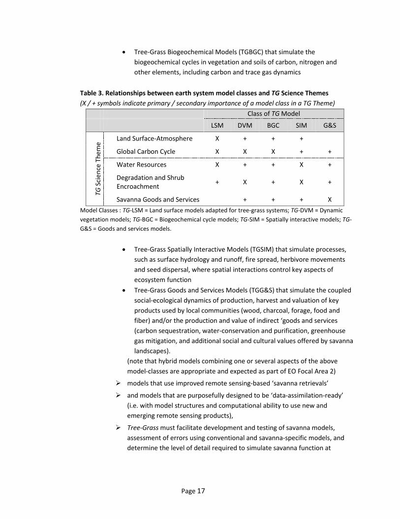
Table 3. Relationships between earth system model classes and TG Science Themes (X / + symbols indicate primary / secondary importance of a model class in a TG Theme)
Class of TG Model
LSM DVM BGC SIM G&S
TG S
cien
ce T
hem
e
Land Surface-Atmosphere X + + +
Global Carbon Cycle X X X + +
Water Resources X + + X +
Degradation and Shrub Encroachment + X + X +
Savanna Goods and Services + + + X Model Classes : TG-LSM = Land surface models adapted for tree-grass systems; TG-DVM = Dynamic vegetation models; TG-BGC = Biogeochemical cycle models; TG-SIM = Spatially interactive models; TG-G&S = Goods and services models.
• Tree-Grass Spatially Interactive Models (TGSIM) that simulate processes,
such as surface hydrology and runoff, fire spread, herbivore movements and seed dispersal, where spatial interactions control key aspects of ecosystem function
• Tree-Grass Goods and Services Models (TGG&S) that simulate the coupled social-ecological dynamics of production, harvest and valuation of key products used by local communities (wood, charcoal, forage, food and fiber) and/or the production and value of indirect ‘goods and services (carbon sequestration, water-conservation and purification, greenhouse gas mitigation, and additional social and cultural values offered by savanna landscapes).
(note that hybrid models combining one or several aspects of the above model-classes are appropriate and expected as part of EO Focal Area 2)
models that use improved remote sensing-based ‘savanna retrievals’
and models that are purposefully designed to be ‘data-assimilation-ready’ (i.e. with model structures and computational ability to use new and emerging remote sensing products),
Tree-Grass must facilitate development and testing of savanna models, assessment of errors using conventional and savanna-specific models, and determine the level of detail required to simulate savanna function at
Page 18
precisions appropriate to earth system modeling needs and Tree-Grass Science Themes (Figure 4).
2.2.3. EO Focal Area 3: Data Assimilation Objective: Capitalize on emerging model-data-assimilation (MDA) methodologies, and improving tree-grass remote sensing retrievals, to further the assimilation of diverse EO data streams into earth system models, improve model performance, and provide fully integrated EO solutions that will be valuable for monitoring and managing terrestrial ecosystems.
Constrain earth system models with spatially and temporally resolved remote sensing and field based data. In particular TG will focus on:
• Enhancing adoption of remote sensing data into tree-grass models via formal MDA (e.g. Barrett et al. 2005); this capability is currently more advanced in certain Land Surface Models (Kaminski et al. 2002; Renzullo et al. 2008) and Hydrological Models (Franks and Beven 1000; Freer et al. 1996), but relatively undeveloped for other model classes or in formulations appropriate to tree-grass systems
• Exploring the reformulation of MDA from the common situation of “temporally rich-spatially poor” (e.g. climate model assimilation of meteorological station data) to the “temporally poor-spatially rich” situation appropriate for longer-term vegetation community and ecosystem processes
New data assimilation and model-data fusion approaches provide opportunities (not available during earlier NASA field campaigns) to more closely integrate earth system models with geospatial datasets (Luo et al. 2011)
Tree-Grass will capitalize on the emerging and convergent opportunities provided by improved data assimilation and remote sensing technologies to realize the full potential of remote sensing in earth system models and improve our ability to monitor, diagnose and predict earth system dynamics
2.3 Tree-Grass Interdisciplinary Applications: Human Wellbeing and Sustainability NASA has long sought to develop remote sensing products and earth observation systems that can be applied for management of the earth system to the benefit of mankind. This aim is particularly pertinent in the global savannas and tree-grass systems that often support economically and politically marginalized rural communities.
EO Focal Area # 3

Page 19
Goals for Tree-Grass Interdisciplinary Applications are to enhance understanding and prediction, and contribute to improved sustainability and human wellbeing. Tree-Grass research will provide opportunities to:
monitor trends in savanna health, sustainability, resilience and vulnerability; provide integrated predictions of how the role of savannas in the earth
system (carbon, water, energy, atmospheric chemistry and dynamics) will change with changing climate and land use on ;
assess the likely impacts and trade-offs in provision of goods and services with changing climate and land use;
contribute to local, national and international management of savannas; benefit the often poor and vulnerable human populations that rely on global
tree-grass and savanna ecosystems.
3. Tree-Grass Research Strategy 3.1 Overall Approach The TG Science Framework presented in Section 2 (Figure 4) outlines the Overarching Questions, Science Themes and EO Science Focal Areas for the Tree-Grass activity. In this section we detail strategies and research priorities for a phased implementation of the TG research program (Figure 5).
Research funds in Phase 1 will concentrate (primarily, but not exclusively) on synthesis and evaluation of remote sensing, modeling and data assimilation technologies in the savannas and more detailed planning of field, remote sensing and modeling activities in Phases 2 and 3. Phase 2 will focus on intensive and extensive field research to improve remote sensing, model and data assimilation technologies (i.e. the EO Focal Area) across the five TG Science Themes, and activities in Phase 3 will focus on development of applications relevant to monitoring and prediction, and on-the-ground management for sustainability and livelihoods in the world’s savanna regions (TG Interdisciplinary Applications). Education and outreach programs will be implemented throughout the TG program and will be designed not only to help develop next generation EO scientists, but will also focus on transfer of knowledge and ready-to-implement applications for practitioners and managers in the USA and internationally (Section 4).
The TG program will be highly interdisciplinary across multiple Science Themes, Earth Observation Focal Areas and field activities. TG will be a proposal-driven activity in which compelling individual and team proposals will determine the research portfolio emerging, with coordination from NASA and TG project managers to ensure program coherence.
Tree-Grass Approach

Page 20
Figure 5. Implementation Strategy for the Tree-Grass research program
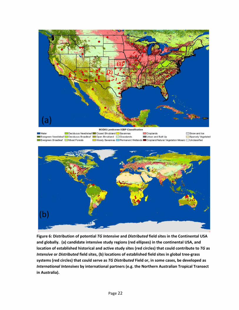
3.2 Candidate Study Sites and Regions Field research in TG will reflect a strategy for very detailed, geographically focused and comprehensive research at a limited number of “Intensive” savanna field sites, in one (or more) regions, with a complementary program of less detailed, more globally representative, research at a larger number of “Distributed” field sites (Figure 6). This strategy will promote the synergies and efficiencies inherent in the concentration of resources and cutting edge research in ecosystem function, remote sensing and modeling at Intensive sites, while Distributed sites will sample the huge range of structural, physiological, bioclimate, edaphic and anthropogenic diversity in the global savannas. Thus, where the Intensive sites may be the primary locus of technological advances in remote sensing science and savanna modeling during the TG program, the Distributed sites will provide opportunities for application, parameterization and validation of new EO technologies across globally diverse tree-grass structural and functional characteristics.
Intensive Sites: Intensive sites supported by NASA as part of the TG program will be located in North America, in key tree-grass ecosystems of the continental USA, with possible addition of sites in Northern Mexico if needed to capture climatic or other environmental or management gradients (Figure 6a). NASA and
Phase 1: Tree-Grass EO Synthesis & EvaluationData synthesis, remote sensing evaluation, data-
model assimilation enhancement, Phase 2 planning
Phase 2: Tree-Grass Field CampaignsIntensive and distributed field campaigns; responding
to Tree-Grass Science Themes and EO focal areas; remote sensing science, savanna model development
and geospatial data assimilation
Phase 3: Tree-Grass ApplicationsApplications for regional-global monitoring, diagnosis
and prediction, relevant to earth system dynamics, sustainability, livelihoods and risk management
Overlapping Time Frames
NRA-1(Years 1-3)
NRA-2 (Yrs 3-5)NRA-3 (Yrs 5-7)
NRA-4 (Years 7-9)
Enhance observation, modeling & data-assimilation capabilities in savannas; improve understanding of their response to climate and anthropogenic change; improve management for sustainability and human well-being
Note: NASA Research Announcement (NRA) sequence indicates primary focus for each NRA, but synthesis, field activities and applications may be proposed as appropriate throughout
Note: NRA respondents will link proposals to Tree-Grass Science Themes, EO focal areas, and applications, but emphasis may change between investigators and through time
Tree-Grass Intensive Field Sites

Page 21
the Tree-Grass program should begin selection of study regions and sites during project planning prior to Phase 1, and complete selection during Phase 1, after appropriate consultation with the community of actual (and potential) lead investigators. Intensive study regions will leverage existing sites and infrastructure. Candidate regions suggested here include a north-south transect in oak and pine savannas along the deciduous woodland-prairie boundaries of Wisconsin-Illinois-Missouri-Arkansas-Texas (the “Ecotone Transect”), and an east-west transect from south-western Texas into New Mexico, Arizona and California (mesquite, creosote pinyon-juniper and oak shrublands – the “Southwest Transect” (Figure 6a). In addition to their differences in species composition, shrub/tree morphology and stature, these transects provide contrasting rainfall and temperature climate and seasonality gradients, as well as contrasting physiological (e.g. C3 and C4 physiology of grasses) and functional characteristics (e.g. role of biotic invasions, fire and grazing). Specific sites in these regions could be selected from existing long term study sites (e.g. long-term ecological research sites, Ameriflux, Agricultural Research Service and individually established sites), to benefit from historical data and existing infrastructure. Alternatively, new sites may be developed for more targeted sampling of specific eco-climatic, edaphic or management gradients.
Individual PIs or consortia of PIs will be able to nominate specific sites or a network of sites as primary locations for intensive activities. To avoid dilution of resources and ensure critical mass at the intensive research sites, however, research teams may be requested to move their activities to TG-agreed intensive sites rather than implement proposed activities at other locations.
Distributed Sites: TG Distributed site selection (and planning for the types and extent of activities that will be carried out on these sites), will begin prior to, and be finalized during, Phase 1, in consultation with the TG and international science community. Distributed sites will likely include already-established field sites in tree-grass and savanna locations in North America and world-wide, and new locations selected to improve spatial sampling of tree-grass structural and functional variability. Data from many already-established sites would be compiled for the TG database in Phase 1 (Figure 6b).
TG activities at Distributed sites will concentrate on measurements of ecosystem structure and function of value to the larger TG program in provision of geographically, climatically and ecologically distributed data for parameterization and validation of remote sensing retrievals and model simulations. The type, frequency and duration of research that may be proposed at the Distributed sites will depend on the science needs of each proposal, but should reflect the ‘large number of sites sampled at low intensity’ strategy of these sites. Given the potential number and global distribution of Distributed sites, a minimal
Tree-Grass Distributed Field Sites
Page 22
Figure 6: Distribution of potential TG Intensive and Distributed field sites in the Continental USA and globally. (a) candidate intensive study regions (red ellipses) in the continental USA, and location of established historical and active study sites (red circles) that could contribute to TG as Intensive or Distributed field sites, (b) locations of established field sites in global tree-grass systems (red circles) that could serve as TG Distributed Field or, in some cases, be developed as International Intensives by international partners (e.g. the Northern Australian Tropical Transect in Australia).
(1)(2)
(a)
(b)
Page 23
measurement set could involve high resolution remote sensing assessments of vegetation parameters that can be used to calibrate or validate coarser resolution remote sensing or model-based assessments, with little or no field component, or could involve single or infrequent visits with rapid assessment of selected key parameters. To facilitate international collaborations in TG, and reduce travel costs, activities at international Distributed sites should involve local collaborators, in so far as is possible given local sources of funding and NASA regulations regarding support for international participants.
3.3 Phase 1: Tree-Grass EO Synthesis and Evaluation
3.3.1 Phase 1 Strategy Phase 1 of TG will focus on the synthesis and evaluation of existing global datasets, remote sensing technologies and modeling capabilities as currently applied to tree-grass systems. Studies will be organized with regard to the five TG Science Themes (Figure 3), or combinations thereof, and with regard to the three EO-Science Focal Areas. Field research will not be a priority for Phase 1 projects but might be proposed as an integral component of proposals where limited field measurements or methods development are considered crucial and can be implemented as a minor cost component of the overall project.
Priority research in Phase 1 will include integration of existing field and remote sensing data from intensive and Distributed field sites worldwide, model assessment, development and benchmarking, and assessment and evaluation of data-assimilation methodologies for tree-grass and savanna models. Proposals in Phase 1 may concentrate on one of these aspects but most will integrate data synthesis activities with one or more of the EO-Science Focal Areas.
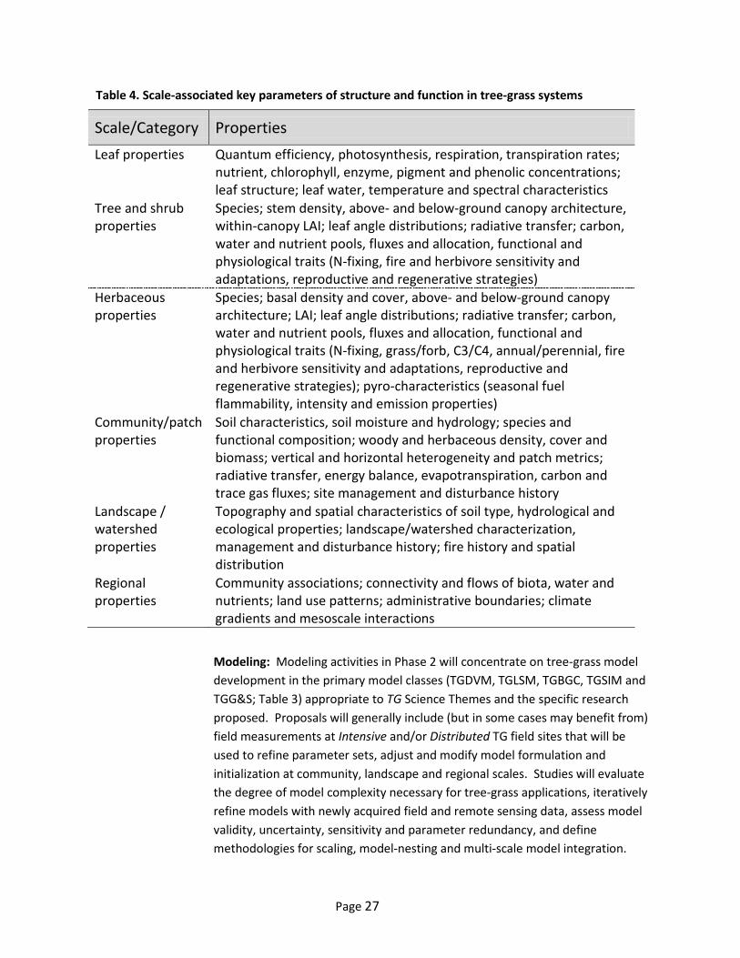
An important goal is to test the capacity of field data sets to develop and test robust and scalable methods using remote sensing to measure key structural and functional parameters in tree-grass ecosystems. A prototype set of key variables and parameters for savanna function is listed in Table 4. The activities in Phase 1 will provide a comprehensive survey of current EO capabilities in tree-grass and savanna systems (including field, model and remote sensing resources and capabilities). This will form the basis for detailed planning and preparation for field activities in Phase 2, and ensure that the science of Phases 1 and 2 of the project extend our ability in Phase 3 to contribute to improved management and sustainability of savannas and tree-grass systems worldwide.
Research Priorities: Research funded in Phase 1 will focus on compilation and synthesis of field measurements, airborne and satellite imagery for all sites where data availability indicate they may provide useful contributions to the larger TG database, model-based exploration of the errors and uncertainties of
Tree-Grass Phase 1 Strategy

Page 24
current-generation models in simulating TG systems, and assessment of model development needs. The TG database development will also be a focus of Phase 1 with contributions from individual projects and/or stand-alone data collation activities.
3.3.2. Phase 1 Science Components Field Data: Field data suited to this activity include existing carbon, water and energy flux measurements, vegetation structure (tree, shrub and herbaceous species composition, demography), phenology, productivity, physiological, morphological and biogeochemical plant traits, carbon pools above and below ground, soil depth, texture and hydrological characteristics. Candidate sites include FluxNet sites in semi-arid and Mediterranean temperate climate and the drought seasonal tropics, and potentially large numbers of field sites worldwide where historical and current vegetation structure and dynamics measurements have been made by ecologists, foresters and others for a variety of reasons (e.g. GTOS/GCOS).
Remote Sensing Science: Remote sensing compilations will focus on collection, processing and standardization of a full suite of EO data from airborne and satellite sources in tree-grass regions (coincident with field sites and/or providing coverage of larger regions and/or continents); assessment and inter-comparison of retrievals for model initialization and parameterization. At present two-layered tree grass systems are not effectively described by satellite remote sensing data sets. This component will propose, develop and test improved retrievals of savanna structure and function from remote sensing using historical and current remote sensing data. Remote sensing methods development for anticipated future (satellite or sub-orbital) instruments, using model or instrument simulators, would also be appropriate in Phase 1.
Modeling: Modeling components will focus on development of parameter sets and initialization data for tree-grass-adapted Dynamic Vegetation Models (TGDVM), land surface models (TGLSM), biogeochemical models (TGBGC), spatially interactive models (TGSIM) and Goods and Services models (TGG&S) at landscape and regional scales; testing of models with historical and limited supplementary data; assessment of parameter redundancy, model structural issues, scaling potential and adaptation to ingest remote sensing data. Improvement of the five model classes, or hybrid combinations, to take account of the physiological, structural and biogeochemical heterogeneity of tree-grass systems will improve our ability to simulate tree-grass population dynamics and responses to variations in climate and disturbances (e.g. fire, herbivory, disease and harvest), the fluxes of energy, water, carbon, and momentum for climate model applications, and the major biogeochemical cycles of water, carbon,
Tree-Grass Phase 1 Science

Page 25
nitrogen and other elements at a range of scales from patch-scale, to landscape, regional and global.
Data Assimilation: Model-data assimilation research will focus on the use of diverse remote sensing datasets using model-data assimilation frameworks for parameterization and prediction. This may make use of existing or novel MDA frameworks with specific reorientation to efficient assimilation of spatially continuous, but temporally discontinuous remote sensing data that contrasts the more common MDA problem using spatially discontinuous, but temporally frequent, data inputs.
Phase 1 activities will define current state-of-the-art in EO applications (remote sensing, modeling and data assimilation) for the savannas, and build on those assessments to refine priority field, remote sensing and modeling needs for Phase 2. Comprehensive data collation, remote sensing and model assessments in Phase 1 will provide key datasets to avoid duplication of effort and increase the efficiency and productivity of research in Phases 2 and 3 of the Tree-Grass program. 3.4 Phase 2: Tree-Grass Field Campaigns
3.4.1 Phase 2 Strategy Following the synthesis and recommendations for priority research emerging during Phase 1, projects funded in Phase 2 will focus on novel combinations of field research, tightly integrated with the three EO-Science Focal Areas, and the five TG Science Themes (Figure 3). TG field activities will combine detailed and comprehensive measurements at a small number of Intensive field sites, with relatively lower-intensity field sampling at a larger number of Distributed field sites. This combination of Intensive and Distributed field sites will allow TG to emphasize detailed and transformational science at the Intensive sites, while recognizing & sampling the huge diversity (in phylogeny, structure, function and management) of tree-grass systems at global scales via the Distributed field sites.
TG field research may include both observational and experimental research (i.e. with or without manipulation of abiotic or biotic, “natural” and anthropogenic variables, and with or without replication, as appropriate to the science) as long as observational and manipulative measurement scales are appropriate for the intended remote sensing data and/or model analysis involved. Observational and experimental field work will be designed to explore tree-grass structure and function for key model parameters and key remote sensing retrievals (Table 4; Appendix 4). Field measurements oriented with respect to climatic (e.g. rainfall, temperature) and edaphic (e.g. soil, topography) gradients are appropriate.
Tree-Grass Phase 2 Strategy
Page 26
Research Priorities: Research funded in Phase 2 will focus on new and innovative field-based research directed at advancing the EO-Science Focal Areas of Remote Sensing Science, Modeling and Data Assimilation in tree-grass and savanna ecosystems. Investigators can propose to work at either or both Intensive and Distributed field sites. They can propose to do no field work themselves, as long as they make use of data from field sites. Priority projects, however, are likely to include field work well integrated with TG-Science Themes and EO-Science Focal Areas. Investigators may propose intensive or Distributed field measurements at specific locations, or indicate flexibility to work at sites selected by the larger TG program. With particular respect to field activities proposed in Phase 2, measurement programs relevant to multiple TG Science Themes (e.g. community and landscape scale vegetation structure and composition measurements; landscape scale soil moisture and hydrology; community and landscape-scale energy, water and carbon fluxes), and multiple EO Science Focal Areas, will be prioritized. 3.4.2. Phase 2 Science Components Field Data: Field measurement programs appropriate in Phase 2 include measurements of vegetation structure (tree, shrub and herbaceous species composition, demography), productivity, physiological, morphological and biogeochemical traits; carbon pools above and below ground; soil depth, texture, biogeochemical and hydrological characteristics; carbon, water, momentum and energy fluxes at plant, stand and landscape scales; and hydrological processes across similar scales (Table 4). Measurements to quantify ecosystem goods and services are appropriate, including direct provision of food, water, fiber, biofuels and other services for humans, and fodder for domestic animals and wildlife, and indirect services relating to ecosystem sources, sinks and storage of carbon, water and trace gases that govern the role of tree-grass systems in climate regulation and change at regional to global scales.
Remote Sensing Science: Remote sensing science programs appropriate in Phase 2 may include detailed field-based radiometry at leaf, canopy and landscape scales, airborne remote sensing using NASA assets, private or commercial platforms, and satellite data acquisitions. Investigator teams may propose research across optical, thermal and microwave domains, including both active and passive systems, as appropriate to their science. Priority will be given to novel remote sensing science proposals, addressing specific tree-grass and savanna remote sensing science issues. Proposals will generally include (but in some cases may benefit from) field measurements at Intensive and/or Distributed TG field sites to develop, test and validate remote sensing retrievals of tree-grass ecosystem structural and functional parameters.
Tree-Grass Phase 2 Science
Page 27
Table 4. Scale-associated key parameters of structure and function in tree-grass systems
Scale/Category Properties Leaf properties Quantum efficiency, photosynthesis, respiration, transpiration rates;
nutrient, chlorophyll, enzyme, pigment and phenolic concentrations; leaf structure; leaf water, temperature and spectral characteristics
Tree and shrub properties
Species; stem density, above- and below-ground canopy architecture, within-canopy LAI; leaf angle distributions; radiative transfer; carbon, water and nutrient pools, fluxes and allocation, functional and physiological traits (N-fixing, fire and herbivore sensitivity and adaptations, reproductive and regenerative strategies)
Herbaceous properties
Species; basal density and cover, above- and below-ground canopy architecture; LAI; leaf angle distributions; radiative transfer; carbon, water and nutrient pools, fluxes and allocation, functional and physiological traits (N-fixing, grass/forb, C3/C4, annual/perennial, fire and herbivore sensitivity and adaptations, reproductive and regenerative strategies); pyro-characteristics (seasonal fuel flammability, intensity and emission properties)
Community/patch properties
Soil characteristics, soil moisture and hydrology; species and functional composition; woody and herbaceous density, cover and biomass; vertical and horizontal heterogeneity and patch metrics; radiative transfer, energy balance, evapotranspiration, carbon and trace gas fluxes; site management and disturbance history
Landscape / watershed properties
Topography and spatial characteristics of soil type, hydrological and ecological properties; landscape/watershed characterization, management and disturbance history; fire history and spatial distribution
Regional properties
Community associations; connectivity and flows of biota, water and nutrients; land use patterns; administrative boundaries; climate gradients and mesoscale interactions
Modeling: Modeling activities in Phase 2 will concentrate on tree-grass model development in the primary model classes (TGDVM, TGLSM, TGBGC, TGSIM and TGG&S; Table 3) appropriate to TG Science Themes and the specific research proposed. Proposals will generally include (but in some cases may benefit from) field measurements at Intensive and/or Distributed TG field sites that will be used to refine parameter sets, adjust and modify model formulation and initialization at community, landscape and regional scales. Studies will evaluate the degree of model complexity necessary for tree-grass applications, iteratively refine models with newly acquired field and remote sensing data, assess model validity, uncertainty, sensitivity and parameter redundancy, and define methodologies for scaling, model-nesting and multi-scale model integration.
Page 28
Data Assimilation: Model-data assimilation research in Phase 2 will extend MDA activities in Phase 1 to benefit from improved and emerging models and remote sensing retrievals specific to the structural and functional complexities of tree-grass and savanna systems. MDA activities in Phase 2 will likely be linked with model development and remote sensing science activities, as well as to field measurements at Intensive and/or Distributed field sites. Linked or consortium proposals may be particularly suited to assure the inter-disciplinary integration of field, RSS, model & MDA activities.
Phase 2 activities will redefine and transform EO science (remote sensing, modeling and data assimilation) for tree-grass and savanna systems. It will contribute significant new understanding of how savannas interact in the earth system and the role of human management and societal feedbacks. Comprehensive new remote sensing and modeling capabilities emerging from the integrated field programs in Phase 2 will lay crucial foundations for the Interdisciplinary Applications planned in Phase 3 of the Tree-Grass program. 3.5 Phase 3: Tree-Grass Applications
3.5.1 Phase 3 Strategy Phase 3 of the Tree-Grass program will emphasize synthesis of TG science and model applications to explore the Overarching Questions (Section 1.5) relating to how tree-grass and savanna biomes will change with climate and land use in future decades, how such changes in the savannas will feedback on the earth system, and how these coupled interactions will impact livelihoods and well-being for the human societies living in, and dependent on, those savanna regions.
Phase 3 will also emphasize the transfer of Earth Observation capabilities and technologies, derived as part of TG research, to understanding, prediction and management of the savannas at landscape to global scales. Projects will address key questions and develop solution-based applications relating to TG Science Themes (Land Surface-Atmosphere Interactions, Global Carbon Cycle, Water Resources, Degradation and Shrub Encroachment, and Savanna Goods and Services), using the enhanced EO capabilities developed during Phase 2 field campaigns and via the EO-Science Focal Areas (Remote Sensing Science, Modeling and Data Assimilation). Proposals in Phase 3 should include outreach and technology transfer plans with appropriate team membership and allocation of resources.
Field research will not be a priority for Phase 3 projects but might be proposed as an integral component of proposals where limited additional field measurements are considered crucial. Field activities may also be proposed in so far as they contribute to outreach, education and applications, or provide context and
Tree-Grass Phase 3 Strategy
Page 29
opportunity for demonstration of TG science to diverse stakeholder communities.
Research Priorities: Research priorities in Phase 3 will emphasize integrated remote sensing and modeling studies that address the questions outlined for the five TG Science Themes in Section 2.1. Geographic focus in Phase 3 will be proposal-driven, but research and applications proposals relating to savanna goods and services, management and sustainability of tree-grass systems may focus on the regions associated with TG Intensive or Distributed field sites. Proposals may also apply models and remote sensing technologies at coarser scales in North America as well as in global tree-grass systems where livelihoods, food security and human wellbeing are closely coupled to savanna dynamics, and where sustainability and productivity are threatened by climate change and degradation. Model studies of tree-grass dynamics under scenarios of future climate and land use change, and how these will impact earth system interactions and provision of goods and services, will be relevant in Phase 3.
4. Tree-Grass Education and Outreach Education and outreach activities will be an integral part of Tree-Grass. Emphasis on graduate and undergraduate education, K-12 education, outreach to the general public, and outreach and technology transfer to practitioners and managers, will change during the course of Phases 1-3 (Table 5).
4.1 Graduate Research Fellowship Program (GRFP) Graduate student education will be encouraged during all phases of the Tree-Grass program. Students will work with individual investigators, funded through inclusion of GRFP costs in PI-led research proposals submitted to biannual NASA Research Announcements. Areas of emphasis for graduate education and research will evolve to reflect changing TG emphasis through Phases 1-3. In addition to coursework and dissertation research at home institutions, all GRFP Fellows will participate in GRFP team-building, co-mentoring and enrichment programs organized by an individual or team of PIs funded via a special GRFP co-ordination element in NRA-1 and NRA-3 (see Table x). Competitive GRFP coordination proposals will outline plans to build and strengthen peer networking among GRFP Fellows, via innovative combinations exploiting the power of electronic communication and social-media, supplemented by annual or biannual side-meetings at TG workshops and/or major conferences. In Years 3-7 GRFP Fellows will also have opportunities to participate (as students and educators) in the E4S Summer Schools (see Section 4.2).
Tree-Grass Graduate Studies
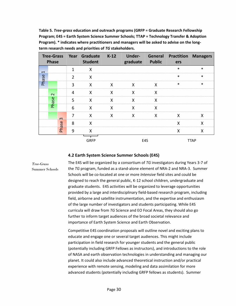
Page 30
Table 5. Tree-grass education and outreach programs (GRFP = Graduate Research Fellowship Program; E4S = Earth System Science Summer Schools; TTAP = Technology Transfer & Adoption Program). * indicates where practitioners and managers will be asked to advise on the long-term research needs and priorities of TG stakeholders.
4.2 Earth System Science Summer Schools (E4S) The E4S will be organized by a consortium of TG investigators during Years 3-7 of the TG program, funded as a stand-alone element of NRA-2 and NRA-3. Summer Schools will be co-located at one or more Intensive field sites and could be designed to reach the general public, K-12 school children, undergraduate and graduate students. E4S activities will be organized to leverage opportunities provided by a large and interdisciplinary field-based research program, including field, airborne and satellite instrumentation, and the expertise and enthusiasm of the large number of investigators and students participating. While E4S curricula will draw from TG Science and EO Focal Areas, they should also go further to inform target audiences of the broad societal relevance and importance of Earth System Science and Earth Observation.
Competitive E4S coordination proposals will outline novel and exciting plans to educate and engage one or several target audiences. This might include participation in field research for younger students and the general public (potentially including GRFP Fellows as instructors), and introductions to the role of NASA and earth observation technologies in understanding and managing our planet. It could also include advanced theoretical instruction and/or practical experience with remote sensing, modeling and data assimilation for more advanced students (potentially including GRFP fellows as students). Summer
Tree-GrassPhase
Year Graduate Student
K-12 Under-graduate
General Public
Practitioners
Managers
1 X * *
2 X * *
3 X X X X * *
4 X X X X
5 X X X X
6 X X X X
7 X X X X X X
8 X X X
9 X X X
GRFP E4S TTAP
Tree-Grass Summer Schools

Page 31
schools may be of varying duration with/without a residential component, as appropriate to the target audience. 4.3 Technology Transfer and Adoption Program (TTAP) The TTAP will be a cornerstone of Phase 3, designed to facilitate and enhance the transfer and adoption of EO technologies to and by appropriate stakeholders, practitioners and managers. TTAP will have a ‘research-to-applications’ and ‘communications’ focus and could, for example, engage GRFP Fellows, many of whom will be working on TG Applications (i.e. Phase 3) projects, in outreach and education. Suitable activities might include web-accessible teaching tools (literature, data and software) and outreach to US teachers on what TG products might be used in earth systems science classes, how they can be used, and why it might be of interest and importance to the students. Similarly, short-course Professional Development opportunities might be developed for State, federal, private and/or public land managers to learn state-of-the-art remote sensing and modeling techniques for US and global tree-grass systems. Such activities will require explicit consideration by TG investigators not only of the how to make research tools operationally valuable, but also the communication and pedagogical methods that will promote understanding, acceptance and adoption of these new tools by the potential user communities.
TTAP activities will be proposed by an individual or consortium of PI’s as a stand-alone element of NRA-4. Mechanisms for outreach and technology transfer may be diverse including direct contact to potential users as well as broad dissemination of results to regional, national and global audiences. TTAP will have dual aims of directly reaching target audiences (managers etc.) via short courses, demonstrations, electronic and print media, whilst also educating TG investigators to enhance outreach and communication of key results and technologies developed by individual research teams.
5. Tree-Grass Organization and Management
5.1 Scientific Leadership
The TG program will be a partnership between NASA and the US Science community, with key international collaborations. Oversight and scientific direction will be provided by a Science Steering Committee (SSC), with representatives from the “tree-grass research” community (academic, Federal, State researchers), and representatives from stakeholder communities (broadly defined as land managers and potential users of improved EO capabilities in tree-grass regions). The SSC should hold regular electronic and teleconference meetings and convene approximately twice-yearly in person for strategic planning and evaluation of TG progress. The SSC will be chaired by the TG
Tree-Grass Technology Transfer
Tree-Grass Leadership

Page 32
Project Scientist. The TG Project Scientist will be a senior scientist, with experience and interest in TG Science and NASA Terrestrial Ecology field programs. This key individual will be selected by NASA from the academic or governmental research community and will be the lead science representative for TG. Given the proposed 9-year duration of the TG project, the Project Scientist position might be re-selected at approximately 3-year intervals to correspond with Phases 1-3 of the project.
The SSC may also include representatives from international partners. These would be key researchers, or representatives from research funding agencies, participating in TG via their field, remote sensing or modeling activities. International representatives will serve to enhance coordination and collaboration between the US based science community and international partners operating International Distributed or Intensive field sites and participating in regional-to-global remote sensing, modeling and synthesis.
The SCC will delegate the task of detailed planning of TG Phases 2-3 to a sub-committee entitled the Science Definition Committee (SDC). The SDC will include member of the SSC, representing the science and programmatic aims of TG, and representatives from the TG Project Office (see Section 5.2) responsible for the practical and logistical aspects of implementation. The SDC will also consult with Phase 1 PI-led science teams and the wider science community to facilitate dialogue on science directions during TG Phases 2 and 3.
5.2 Project Management The TG Project Office (Figure 7) will manage day-to-day operations, field and data-related logistics, and liaison between the SSC, SDC and PI-led research teams. The TG Project Office will be led by a full-time TG Project Manager. The Project Manager will report directly to the Project Scientist and SSC and be tasked with overall management of TG implementation plans as agreed with the SSC and SDC. The Project Manager will be assisted by Project Office administrative staff (estimated at 2 FTE) for budget and personnel management. A Science Team Coordinator (1 FTE) will be responsible for liaison between the Project Office and PI’s, and coordinate with PI-led Education and Outreach activities. The Project Office will also direct a post-doctoral level researcher (1 FTE) to coordinate “core data products”, synthesis and analysis activities (i.e. products of broad TG community interest that can be more efficiently generated centrally, using agreed methodologies, than by individual teams).
The Project Office will also include the TG Data Team and TG Logistics Team (Figure 7) who will report to the Project Manager. Rather than develop new and independent database infrastructure, TG will work with one of the existing Distributed Active Archive Centers (DAACs, e.g. Oak Ridge National Laboratory) to archive and serve TG data for public access. The TG Data Team (2 FTE in
Tree-Grass Management
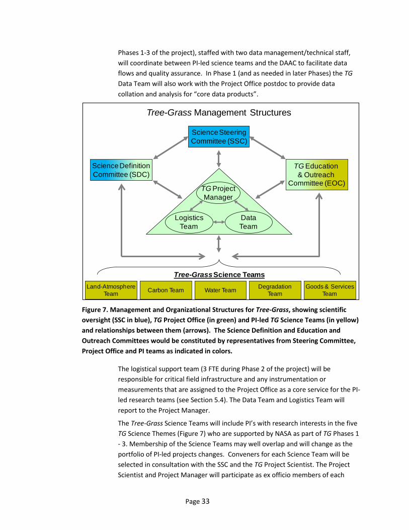
Page 33
Phases 1-3 of the project), staffed with two data management/technical staff, will coordinate between PI-led science teams and the DAAC to facilitate data flows and quality assurance. In Phase 1 (and as needed in later Phases) the TG Data Team will also work with the Project Office postdoc to provide data collation and analysis for “core data products”.
Figure 7. Management and Organizational Structures for Tree-Grass, showing scientific oversight (SSC in blue), TG Project Office (in green) and PI-led TG Science Teams (in yellow) and relationships between them (arrows). The Science Definition and Education and Outreach Committees would be constituted by representatives from Steering Committee, Project Office and PI teams as indicated in colors.
The logistical support team (3 FTE during Phase 2 of the project) will be responsible for critical field infrastructure and any instrumentation or measurements that are assigned to the Project Office as a core service for the PI-led research teams (see Section 5.4). The Data Team and Logistics Team will report to the Project Manager.
The Tree-Grass Science Teams will include PI’s with research interests in the five TG Science Themes (Figure 7) who are supported by NASA as part of TG Phases 1 - 3. Membership of the Science Teams may well overlap and will change as the portfolio of PI-led projects changes. Conveners for each Science Team will be selected in consultation with the SSC and the TG Project Scientist. The Project Scientist and Project Manager will participate as ex officio members of each
Tree-Grass Management Structures
Land-AtmosphereTeam Carbon Team Water Team Degradation
TeamGoods & Services
Team
LogisticsTeam
TG ProjectManager
DataTeam
Science SteeringCommittee (SSC)
Tree-GrassScience Teams
Science DefinitionCommittee (SDC)
TG Education & Outreach
Committee (EOC)
Page 34
Science Team to ensure communications among and between SSC, Project Office and Science Teams. Science Team activities will be facilitated and coordinated by the Science Team Coordinator (employed in the Project Office) who will assist with organization of Team workshops and communication.
The role of the Science Teams is to coordinate among PI-led projects, and with the Project Office, to ensure coherent progress towards the aims and objectives of the corresponding TG Science Themes. This may include discussion and coordination of PI-led research to fill gaps and enhance synergies. It may also include discussions with SDC and SSC on research strategies and priorities, and efforts to ensure collaboration and integration with the other Science Teams and corresponding Science Themes.
Education and Outreach activities during TG will be coordinated by individual PI’s or consortia of PI’s via an independent proposals process (or potentially organized as education supplements to funded research proposals), as part of NRAs 1, 2, and 4. The Project Office, via the Science Team Coordinator, will contribute to and assist with the activities planned as part of the Graduate Research Fellowship Program (GRFP), the Earth System Science Summer Schools (E4S) and the Technology Transfer and Adoption Program (TTAP) (see Table 5).
5.3 Partnerships and Collaborations Within the United States the Tree-Grass program is particularly relevant to the research interests and management missions of a large number of academics, researchers, extension officers and managers in universities, State and Federal agencies. In particular, researchers and managers of non-agricultural lands (grazing lands and protected areas) across huge areas of Western and Southern United States, from the Long-leaf pine savannas of Florida, through to the oak and scrub savannas of Texas, New Mexico and Arizona; in the shrublands of the Colorado Plateau and Great Basin; in the Mediterranean savannas of California, and in remnant transition woodlands of Illinois, Iowa, Oklahoma and north-eastern Texas. As such we anticipate keen interest not only from the academic community, but also from Federal agencies, including the Bureau of Land Management, National Park Service, Forest Service, USDA-Agricultural Research Service, Natural Resource Conservation Service and US Geological Service, and their State-level equivalents. Contact with some of these agencies was initiated during the scoping study via participants in the SRS workshop and consultative process. Extensive links are already underway with the relevant research networks, including the Ameriflux (eddy covariance) network, the National Science Foundation Long Term Ecological Research (LTER) network, and the fledgling National Ecological Observatory Network (NEON).
Tree-Grass Partners

Page 35
Figure 8. The scientific imperative and collaborative advantages of an international component in the Tree-Grass program. The global reach and relevance of TG is achieved via proposed ‘Distributed sites’ (i.e. low intensity sites with broad global coverage) and the possible addition of ‘Intensive sites’ funded by international partners in countries outside the USA, with science elements similar to the TG Intensive sites in North America.
The global extent of savannas with diverse bioclimatic and management characteristics, and contrasting research emphasis in the local science communities, make it essential that TG reach out and collaborate with key partners worldwide (Figure 8). From a field science perspective, scientists and their host institutions from Australia, Africa, South America. South and South-East Asia should be partners in this process. In addition, US and international research groups have key and complimentary expertise in tree-grass-related field measurements, savanna modeling, savanna remote sensing and human dimensions that should be included in the development and implementation of TG. Thus, in addition to planned TG-funded sampling of global tree-grass systems via the ‘Distributed’ field sites, the concept of “International Intensive Sites” (mirroring activities planned for the US-based Intensive Sites, but primarily funded via local sources) leaves the door open for extensive involvement of those communities in the overall TG program. In preparing for TG, and during Phase 1 of the project, high-level coordination with international researchers and funding agencies will promote this involvement. Discussions have been initiated with the science communities in Australia, Europe, Africa and South America to
Global savannas are physiognomically diverse, related to phylogeny, climate, geology and human-management
Australia – unique vegetation in wet & dry monsoonal climate, few humans, extensive grazingSouth America – unique vegetation in wet tropical climate, many humans, major locus of LUC
Africa – diverse wet & dry tropical savannas supporting subsistence populations, livestock & wildlife, expanding agricultural conversion
USA – temperate semi-arid savannas & shrublands with shrub encroachment & invasive grasses
Leverage international sites
Logic: Earth observation products and models are not well calibrated, validated or
integrated across diverse global savannas
The Tree-Grass project can leverage complementary activities in global savannas through international collaborative linkages
Australia – extensive savanna research, established well-instrumented network of sitesSouth America – established sites & LBA legacy in Brazil, savanna researchers in other SA countriesUSA – well instrumented sites in diverse vegetation types with differing change dynamics Africa – Many low intensity field sites in South, East and West Africa, plus a smaller number well instrumented
Logic: International science community and funding agencies bring
significant expertise and resources
Leverage international science
community

Page 36
explore development of these ‘International Intensives’ that will expand the scope and international reach of the Tree-Grass Program.
5.4 Field Operations The proposed strategy of concentrating TG field research in North America will reduce cost and logistical difficulties. For example, travel costs to sites in North America for the Project Office and PI-led research groups will be modest relative to costs incurred for international travel. Furthermore, we do not anticipate that it will be necessary to construct accommodation at field sites since suitable accommodation is generally available in the proposed study regions. It might prove necessary for the Project Office (PO) to improve the research infrastructure at intensive field sites, but at relatively modest cost to TG (e.g. trailers could be used instead of permanent buildings to provide laboratory space when not already available). The PO would also manage issues of power supply and access to sites, tower construction and other forms of sampling infrastructure, where necessary. The SDC might determine that the PO should conduct core (“service”) measurements at intensive sites in North America and/or at US and International distributed field sites, but most field measurement programs would take place as part of PI-led research projects.
International intensive sites would be funded and managed primarily by international partners, in consultation and coordination with the SSC. NASA-funded activities at these sites might include data acquisition using NASA satellite, sub-orbital and airborne EO resources over international intensive and distributed sites, as well as PI-led research , but NASA expenditures for field activities will likely be concentrated in North American field sites.
5.5 Data Management and Sharing TG Phase 1: In Phase 1 the TG Project Office Data Team will develop protocols for standardization and documentation of TG data that will facilitate later archive and distribution of datasets originating from PI-led research projects or Project Office core measurements. Data, models and MDA techniques developed as part of Phase 1 activities will be collated and archived for rapid access by other TG teams and the wider community in a form and at a scale that can be used to develop and test remote sensing retrievals and various models (Table 6). The TG Data team will be work with Investigator teams to ensure that data submissions to the TG Database are quality controlled, standardized and in agreed formats, with full documentation and metadata. They will work with an established DAAC (e.g. the ORNL DAAC) to facilitate broad community access to data in a globally accessible archive and distribution facility. The centralized TG Database will be made available for Phase 1 synthesis, regional and global data analysis, and increase early access to data during proposal development for Phase 2 projects.
Tree-Grass Field Operations
Tree-Grass Data Plan

Page 37
Table 6. Data typology for TG Database
TG Phase 2: The TG Database developed in Phase 1 will continue expansion as an archive and distribution facility for field and remote sensing datasets acquired during Phase 2. Data from Intensive and Distributed sites will be made available to TG investigator teams, and the database will serve as a repository for remote sensing and model simulations for individual sites and for regional and global tree-grass systems (Table 6). TG investigators will be required to submit algorithms, model source-code and derived and synthetic products for archive and distribution. Recognizing that advancing the TG Science Themes will require interdisciplinary collaboration and access to data among research teams (with different emphasis on field, remote sensing and modeling activities), default TG data policies will encourage immediate data submission and sharing, with minimal provision for sole-use periods, but strong provisions to ensure due recognition of intellectual property, data sources and collaboration. The TG Database will be available for archive and distribution of data from International Intensive sites if requested by international partners.
TG Phase 3: In Phase 3 the TG database will further evolve to provide not only data archive and distribution services, but also public access to TG Applications designed for monitoring and management of tree-grass systems. This will include facilitation of the TTAP outreach activities and applications-oriented PI-led science programs. As part of Phase 3 the TG Data Team will develop a clearly defined plan for the long-term archive and distribution of TG data, including
Global Synthesis
Sites
TG Intensive
Sites
TGDistributed
Sites
Internat.Intensive
SitesRegional Continental Global
Non-Spatial
Field Measurements X X X X
Remote Sensing Imagery X X X X X X X
Remote Sensing Value-Added X X X X X X X
Model Simulations X X X X X X X
Data-Synthesis Datasets X X X
TG Model Library X
RS Algorithm Library X
MDA Code Library X
TG Literature Database X X X X X X X
Collection Scale

Page 38
strategies to continue production and distribution of key products and applications of value to TG stakeholders.
6. Summary of National and International Research Community Interest in Tree-Grass 6.1 Tree-Grass science community interest
The NASA call for scoping studies came at a time when many in the savanna remote sensing, ecology and modeling community were considering the current status and future of EO technologies (remote sensing and modeling) as applied in tree-grass around the world. Various groups had, for example, initiated workshops and conference sessions on savanna ecology and methodologies for large scale measurement and modeling. These included a colloquium on savannas at the 2008 AGU Fall Meeting, discussions as part of AMMA and CarboAfrica meetings in Africa and Europe, a workshop on biomass assessment in South Africa following IGARRS (July 2009), and an International Savanna Working Group convened in 2008-2009 with support from the Australian Research Council.
The NASA scoping study provided an ideal opportunity to build on that momentum and gather a larger and more comprehensive community to consider in greater depth the characteristic needs and emerging opportunities for remote sensing and modeling of savanna regions. As part of the Scoping Study we invited 50 leading savanna specialists, from academia and government research laboratories, and from countries in North and South America, Europe, Africa and Australia, to attend the “Savanna Remote Sensing” workshop in Fort Collins in March 2010. The workshop format included 12 invited keynote presentations and breakout sessions organized to define scientific and technological needs and opportunities for a NASA Terrestrial Ecology research program in global tree-grass ecosystems.
The Scoping Study also benefits from contributions from SRS workshop participants and others in the savanna community to a major new book entitled “Ecosystem Function in Savannas: measurement and modeling at landscape to global scales” published by Taylor & Francis/CRC Press (Hill and Hanan 2011). The proposals outlined in this white paper respond to the needs and frustrations of the savanna community, and represent a synthesis of ideas and recommendations emerging from the book, and during the SRS workshop.
6.2 Relevance to US Federal and State Agencies
Tree-Grass research will contribute directly to the measurement, modeling, understanding and management of the huge tree-grass areas of South, South-
Tree-Grass and the science community
Tree-Grass and Federal lands

Page 39
West and Western USA, many of which are managed by Federal agencies such as the Bureau of Land Management (BLM), Forest Service, Department of Defense and the National Park Service. Extensive tree-grass landscapes in the South-West and West are also managed by a variety of State, local and tribal (Native American) entities. Our intent with Tree-Grass is to generate much improved technologies for monitoring and modeling these systems, and to develop tools that will be made available to these diverse stakeholders via the education, outreach and applications activities that are integral to Phases 2 & 3 of the program. We anticipate that stakeholders will be engaged directly during E4S summer schools, via direct contact with TTAP outreach, or as they become increasingly aware of TG data and resources made available via electronic media. Given the crucial role that semi-arid tree-grass systems play in the livelihoods of so many subsistence pastoral and agropastoral communities in Africa, Asia, South and Central America, the TG program will also be of direct relevance to USAID’s new “Feed the Future” initiative.
6.3 Relevance to International Global Change and Sustainability Research
Tree-Grass science themes and priorities are consistent with, and will contribute significantly towards, international science frameworks including the Global Earth Observation System of Systems (GEOSS) and the Earth System Science Partnership (ESSP; Diversitas, IGBP, IHDP and WCRP) for whom the USA is a major task leader on many elements. By the time Phase 3 of Tree-Grass is ready for implementation (which would be around 2020 based on best estimates), it is likely that land cover and land use change in savannas will have substantially expanded, and some regional impacts of climate change may be starting to be measurable. The IGBP is currently working on a developing a new “grand challenge” agenda to “advance earth system research for meeting global sustainability challenges”. The improved EO capabilities generated in Tree-Grass will provide a core capability under these frameworks.
We recognize that, in the Tree-Grass science context there is great value in additional intensive measurements in the diverse tree-grass systems of the world (e.g. South American, Australian and African savannas, shrublands and dry deciduous woodlands of Central America, Central and South Asia). Based on discussions with the US and international community in preparation of this white paper we recommend that NASA concentrate Intensive measurements in North America, but retain a global component in two ways: first through the novel addition of the ‘Distributed’ network of sites, and second through the potential that international science communities and funding agencies may leverage their own resources to implement international Intensives similar to that which TG will deploy in North America, but at little or no cost to NASA (Section 5.3). This strategy will increase the efficiency and cost-effectiveness of NASA’s investment,
Tree-Grass and the International Science Agenda

Page 40
enhance the global relevance of TG research, and provide a mechanism for vibrant international collaborations. Initial discussions with partners in Australia, Europe, Africa and South America, suggest strong interest to leverage existing research sites and activities to participate actively in the global TG Program. These linkages will be further developed and formalized as the TG Program goes forward. We stress, however, that the TG strategy to deploy North American Intensive Sites together with globally Distributed Sites means that TG will sample, and be relevant to, global tree-grass systems. The addition of International Intensives (with support from local funding agencies) will enhance the research program, but TG is not dependent on these developments.
7. Resources Needed for Tree-Grass
7.1 Field Infrastructure Significant infrastructure relevant to TG already exists at sites in North America and globally (a sample of potential sites are shown in Figure 6). Potential sites include the densely instrumented sites typical of the Ameriflux and FluxNet eddy covariance sites (http://ameriflux.ornl.gov and http://www.fluxnet.ornl.gov ) in regions and sites with appropriate tree-grass and shrub-grass vegetation communities. They include several long-term ecological research network sites (LTER, http://lternet.edu ) and their International equivalents, as well as individual and networked field sites with a range of historical and on-going research into vegetation and ecosystem dynamics (Figure 6).
Where possible and conducive to TG science, the TG project will leverage and build on existing sites, with addition of infrastructure as necessary, coordinated in some cases by the TG Project Office or proposed and organized as part of PI-led research. If necessary to achieve science goals and fully sample across key gradients, the TG project should consider adding both Intensive and Distributed field sites. The Phase 2 suite of field measurements and instrumentation at both Intensive and Distributed field sites should be finalized during Phase 1 planning modified, where appropriate, by the competitive proposal process and funded PI-led research.
We can, however, anticipate that TG Intensive sites will include field measurements directed at addressing knowledge gaps relevant to the 5 Science Themes and the 3 EO Focal Areas. In particular TG emphasis on Remote Sensing Science and Process Modeling would indicate the need for dual focus on i) canopy structure and remote sensing technologies for tree-grass retrievals (e.g. functionally resolved canopy structure through a range of traditional (e.g. destructive and non-destructive census methodologies) and non-traditional techniques (e.g. canopy LiDAR, photometric and radiometric techniques) coupled with ground based remote sensing, radiative transfer and algorithm
Tree-Grass field infrastructure needs

Page 41
development, and ii) ecosystem function, including soil and canopy physiology and biogeochemistry, energy, water, carbon and trace gas fluxes (e.g. leaf and canopy-level gas and energy exchange measurements via chambers or eddy covariance measurements). The TG Project Office might play an important role here in installation of key instrument systems at individual Intensive sites including, for example, ground-based canopy LiDAR measurements for characterization of canopy structure, eddy flux measurements of land surface-atmosphere exchanges of energy, water and carbon, and other meteorological and soil physical measurements. 7.2 Suborbital platforms and sensors Aircraft remote sensing will likely play a central role in development and testing of tree-grass retrieval algorithms that benefit from synergies between active, passive, optical, thermal and microwave imaging systems. In proposing candidate sites and transects in North America we envisage an airborne sampling strategy with short-range remote sensing from light aircraft, and long-range and high altitude aircraft able to integrate across the broad regional and continental scale gradients. Both NASA and non-NASA aircraft may be used in this endeavor, with funding for key suites of airborne measurements and instruments (“community remote sensing” determined during Phase 1) routed through the project office. PI’s will likely also propose local or more specialized instrument deployments as part of research proposals.
It is likely that synergies may be obtained with the intensive and extensive airborne imaging planned for the NEON network and continuing activities as part of the North American Carbon Program (NACP). Furthermore, the current model for the NASA DC-8 of intensive multi-instrument missions with dedicated education components through student-proposed science activities could be applied to an airborne campaign around savanna sites in the conterminous USA.
For logistical and cost reasons, aircraft remote sensing over international Distributed sites (and the possible International Intensive sites added by international collaborators) will occur at lower intensity than over North America. However, NASA investigators (or international collaborators) may propose to ship specific sensors for deployment on local aircraft (for example, the AVIRISNG sensors are small and portable). Or given the proliferation of commercial providers of high spatial and spectral resolution of airborne sensors, TG PI’s may contract data acquisitions oversees. International Intensive science programs would likely have airborne science components already, as is the case for the Australian NATT Transect for example, that could provide piggy-back opportunities.
Tree-Grass aircraft needs
Page 42
7.3 Satellite data access and purchase The suite of currently available and future planned satellites and space-borne sensors changes on a very regular basis (Appendix 4). The global swathe coverage class of optical sensors will provide continuous and free data from MODIS until 2017 and from VIIRS on NPP (launched in October 2011) until the JPSS mission with a second VIIRS on board is launched. Landsat continuity has been compromised for 2012 by the failure of Landsat 5, but it is expected that successful launch of Landsat 8 in early 2013 will ensure access to these data into the future. Given the importance of the seasonal rainfall cycles in tree-grass systems, GPM (Appendix 4), the successor sensor to TRMM, will be a vital source of data for Tree-Grass MDA projects. In addition, with the demise of the DESDYNI LiDAR and suspension of the DESDYNI radar until the 2020’s, ICESAT-2 capability (Appendix 4), and particularly photon counting within the footprint, may be vital to assist calibration of available optical and SAR imagery in refining structure and biomass estimation in tree-grass systems.
The new Sentinel series sensors planned by the European Space Agency will also be vital for the Tree-Grass program. Initial development of TG should include formulation of agreements with ESA to image key Intensive and Distributed study sites, and to regularly acquire swathe coverage of major savanna systems to facilitate scaling up from sites to biome scales.
Access to high resolution optical data is of particular importance for Tree-Grass, since capture of spatial properties of savanna landscapes, including tree canopy delineation, shadow patterns, clumping and patch structures is essential for connection of structure with ecosystem function, and disaggregation of sub-pixel signals in EOS MODIS and VIIRS optical data. It is therefore important that an agreement and funding be defined for necessary access to GeoEye-1 and Digital Globe very high resolution optical data.
In the absence of DESDYNI radar, access to both archives and future acquisitions of C-band and L-band SAR will also be very important for the Tree-Grass Program. Research on biomass in tree-grass and savanna systems has shown that combination of optical, SAR and LiDAR data is needed to gain effective measurement fidelity for structure and biomass. In the initial stages, the program should obtain full access to archives from the ESA ASAR, and ALOS PALSAR missions, and arrange a close PI relationship with JAXA for the ALOS-2 sensor. These data may be vital for merging with airborne LiDAR acquisitions.
Tree-Grass satellite data needs

Page 43
7.4 Approximate Total Cost Estimates for Tree-Grass
TG Outline Budget (1)
Per Year (2) 9 Year TotalProject Scientist (3)
Project Scientist (0.5 FTE) (4) 96,000 864,000Research Support Staff (1.5 FTE) 93,600 842,400Travel, Coordination and Research Supplies 50,000 450,000Indirect Cost at 25% 59,900 539,100
Project Scientist Total 299,500 2,695,500Project Office (5)
TG Project Manager (1 FTE) 120,000 1,080,000TG Administrative Staff (2 FTE) 144,000 1,296,000TG Science Team Coordinator (1 FTE) 96,000 864,000PO-Directed Research Postdoc (1FTE) 96,000 864,000TG Data Support and DAAC Liaison (2 FTE) 192,000 1,728,000DAAC Support (Hardware costs etc) (Yrs 1-3) 100,000 300,000TG Field Crews (3 FTE; Yrs 3-7) 234,000 1,170,000PO Travel (National, international) 100,000 900,000Annual Workshop Organization 100,000 900,000SSC Travel 40,000 360,000Indirect Cost at 25% 305,500 2,365,500
TG Project Office Total 11,827,500EO Data & Technology Support (Project Office) (6)
Airborne Remote Sensing (yrs 3-7) 2,000,000 10,000,000Satellite Data Purchases (Yrs 1-9) 250,000 2,250,000High Performance Computer Time (Yrs 1-9) 100,000 900,000
EO Support Total 13,150,000Field Logistics and Instrumentation Support (Project Office)Intensive Site Infrastructure (Yr 3, 4) 600,000 1,200,000Intensive Site Instrumentation (Yr 3-4 purchases) 400,000 800,000Distributed Site Instrumentation/Logistics (Yr 3-4 purchases) 100,000 200,000
Field Support Total 2,200,000Project Office Total (Office, EO and Field) 27,177,500
Education and Outreach Coordination (PI-led)GRFP (0.2FTE; workshop costs, travel; yrs 1-9 funded in NRA-1 & 3) 249,000 2,241,000E4S (8 PI @ 0.15 FTE, 1 FTE, summer school costs; yrs 3-7, funded in NRA-2&3) 843,000 4,215,000TTAP (8 PI @ 0.15 FTE, 1.0 FTE, outreach activities, yrs 7-9, funded in NRA-4) 843,000 2,529,000
Education & Outreach Total 8,985,000PI-Led SciencePhase 1, NRA 1 (~10 projects averaging @750k over 3 yrs) 2,500,000 7,500,000Phase 2, NRA 2 (~20 projects averaging @750k over 3 yrs) 5,000,000 15,000,000Phase 2, NRA 3 (~20 projects averaging @750k over 3 yrs) 5,000,000 15,000,000Phase 3, NRA 4 (~15 projects averaging @750k over 3 yrs) 3,750,000 11,250,000
PI-Led Science Total 48,750,000PI-led Science + Education & Outreach 57,735,000
TREE-GRASS TOTAL ESTIMATED COSTS (9 years) 87,608,000Notes: 1. All budget estimates to be refined during detailed project planning prior to project initiation 2. Budget items repeat over 9 years unless indicated in item description 3. Project scientist could be from University, NASA Center or other Federal Agency 4. All FTE salary estimates include a 20% fringe benefit component 5. Project Office hosted by NASA Center or University 6. EO flight time and satellite data needs to be refined during pre-planning and Phase 1 of project

Page 44
8. References Andreae, M. O. (1991). Biomass Burning: Its History, Use and Distribution and Its Impact on
Environmental Quality and Global Change. Global Biomass Burning: Atmospheric, Climatic and Biospheric Implications. J. S. Levine. Cambridge, MA, MIT Press.
Andreae, M. O., E. Atlas, G. W. Harris, G. Helas, A. de Kock, R. Koppmann, W. Maenhaut, S. Mano, W. H. Pollock, et al. (1996). "Methyl halide emissions from savanna fires in southern Africa." Journal of Geophysical Research 101(D19): 23603-23614.
Archer, S., D. S. Schimel and E. A. Holland (1995). "Mechanisms of Shrubland Expansion - Land-Use, Climate or CO2." Climatic Change 29(1): 91-99.
Asner, G. P. and K. B. Heidebrecht (2005). "Desertification alters regional ecosystem-climate interactions." Global Change Biology 11(1): 182-194.
Barrett, D. J., M. J. Hill, L. B. Hutley, J. Beringer, J. Xu, G. D. Cook, J. Carter and R. Williams (2005). "Prospects for improving savanna carbon models using multiple constraints model-data assimilation methods." Australian Journal of Botany 55: 689-714.
Beerling, D. J. and C. P. Osborne (2006). "The origin of the savanna biome." Global Change Biology 12(11): 2023-2031.
Bégué, A., S. D. Prince, N. P. Hanan and J. L. Roujean (1996). "Shortwave radiation budget of Sahelian vegetation. 2. Radiative transfer models." Agricultural and Forest Meteorology 79(1-2): 97-112.
Beringer, J., L. B. Hutley, J. M. Hacker, B. Neininger and K. T. Paw U (2011). "Patterns and processes of carbon, water and energy cycles across northern Australian landscapes: from point to region." Agricultural and Forest Meteorology (in press).
Bond, W. J. (2008). "What limits trees in C4 grasslands and savannas?" Annual Review of Ecology, Evolution and Systematics 39: 641-659.
Bourliere, F. and M. Hadley (1970). "The ecology of tropical savannas." Annual Review of Ecology and Systematics 1: 125-152.
Bradley, B. A., R. A. Houghtonw, J. F. Mustard and S. P. Hamburg (2006). "Invasive grass reduces aboveground carbon stocks in shrublands of the Western US." Global Change Biology 12(10): 1815-1822.
Brovkin, V., M. Claussen, V. Petoukhov and A. Ganopolski (1998). "On the stability of the atmosphere-vegetation system in the Sahara/Sahel region." Journal of Geophysical Research-Atmospheres 103(D24): 31613-31624.
Brown, J. R. and S. Archer (1999). "Shrub invasion of grassland: Recruitment is continuous and not regulated by herbaceous biomass or density." Ecology 80(7): 2385-2396.
Charney, J., W. J. Quirk, S. H. Chow and J. Kornfield (1977). "Comparative-Study of Effects of Albedo Change on Drought in Semi-Arid Regions." Journal of the Atmospheric Sciences 34(9): 1366-1385.
Charney, J., P. H. Stone and W. J. Quirk (1975). "Drought in Sahara - Biogeophysical Feedback Mechanism." Science 187(4175): 434-435.
Charney, J. G. (1975). "Dynamics of Deserts and Drought in Sahel." Quarterly Journal of the Royal Meteorological Society 101(428): 193-202.
Crutzen, P. J. and M. O. Andreae (1990). "Biomass burning in the tropics: impact on atmospheric chemistry and biogeochemical cycles." Science 250: 1669-1678.
Eldridge, D. J., M. A. Bowker, F. T. Maestre, E. Roger, J. F. Reynolds and W. G. Whitford (2011). "Impacts of shrub encroachment on ecosystem structure and functioning: towards a global synthesis." Ecology Letters 14.

Page 45
Franks, S. W. and K. J. Beven (1000). "Conditioning a multiple-patch SVAT model using uncertain time-space estimates of latent hear fluxes as inferred from remotely sensed data." Water Resources Research 35(9): 2751-2761.
Fredrickson, E. L., R. E. Estell, A. Laliberte and D. M. Anderson (2006). "Mesquite recruitment in the Chihuahuan Desert: Historic and prehistoric patterns with long-term impacts." Journal of Arid Environments 65(2): 285-295.
Freer, J., K. Beven and B. Ambroise (1996). "Bayesian estimation of uncertainty in runoff prediction and the value of data: An application of the GLUE approach." Water Resources Research 32(7): 2161-2173.
Friedl, M. A., D. K. McIver, J. C. F. Hodges, X. Zhang, D. Muchoney, A. H. Strahler, C. E. Woodcock, S. Gopal, A. Schnieder, et al. (2002). "Global land cover from MODIS: Algorithms and early results." Remote Sensing of Environment 83: 135-148.
Giannini, A., M. Biasutti and M. M. Verstraete (2010). "A climate model-based review of drought in the Sahel: desertification, the re-greening and climate change." Journal of Climate 64: 119-128.
Hanan, N. P. and C. E. R. Lehmann (2011). Tree-grass interactions in savannas: paradigms, contradictions and conceptual models. Ecosystem Function in Savannas: measurement and modeling at landscape to global scales. M. J. Hill and N. P. Hanan. Boca Raton, CRC Press: 39-56.
Hansen, M. C., J. R. G. Townshend, R. S. DeFries and M. Carroll (2005). "Estimation of tree cover using MODIS data at global, continental and regional/local scales." International Journal of Remote Sensing 26: 4359-4380.
Heisler, J. L., J. M. Briggs and A. K. Knapp (2003). "Long-term patterns of shrub expansion in a C-4-dominated grassland: Fire frequency and the dynamics of shrub cover and abundance." American Journal of Botany 90(3): 423-428.
Herrmann, S. M. and C. F. Hutchinson (2005). "The changing contexts of the desertification debate." Journal of Arid Environments 63(3): 538-555.
Hill, M. J. and N. P. Hanan (2011). Current approaches to measurement, remote sensing and modeling in savannas: a synthesis. Ecosystem Function in Savannas: measurement and modeling at landscape to global scales. M. J. Hill and N. P. Hanan. Boca Raton, CRC Press: 515-546.
Hill, M. J. and N. P. Hanan, Eds. (2011). Ecosystem Function in Savannas: measurement and modeling at landscape to global scales. Boca Raton, CRC Press.
Hill, M. J., N. P. Hanan, W. Hoffmann, R. J. Scholes, S. D. Prince, J. Ferwerda, R. M. Lucas, I. Baker, A. Arneth, et al. (2011). Remote Sensing and Modeling of Savannas: The State of the Dis-Union. International Satellite Remote Sensing of the Environment (ISRSE), Sydney.
Hill, M. J., M. O. Román and C. B. Schaaf (2011). Biogeography and dynamics of global savannas: A spatio-Temporal View. Ecosystem Function in Savannas: measurement and modeling at landscape to global scales. M. J. Hill and N. P. Hanan, CRC Press. 3-37.
Houghton, R. A. and J. L. Hackler (2006). "Emissions of carbon from land use change in sub-Saharan Africa." Journal of Geophysical Research 111.
Kaminski, T., W. Knorr, P. J. Rayner and M. Heimann (2002). "Assimilating atmospheric data into a terrestrial biosphere model: A case study of the seasonal cycle." Global Biogeochemical Cycles 16(4).
Keeley, J. E. and P. W. Rundel (2005). "Fire and the Miocene expansion of C4 grasslands." Ecology Letters 8(7): 683-690.
Knapp, A. K., J. M. Briggs, S. L. Collins, S. R. Archer, M. S. Bret-Harte, B. E. Ewers, D. P. Peters, D. R. Young, G. R. Shaver, et al. (2008). "Shrub encroachment in North American grasslands: shifts in growth form dominance rapidly alters control of ecosystem carbon inputs." Global Change Biology 14: 615-623.
Page 46
Kruska, R. L., R. S. Reid, P. K. Thornton, N. Henninger and P. M. Kristjanson (1999). "Mapping livestock-oriented agricultural production systems for the developing world." Agricultural Systems 77(1): 39-63.
Lehmann, C. E. R., S. A. Archibald, W. A. Hoffmann and W. J. Bond (2011). "Deciphering the distribution of the savanna biome." New Phytologist 190(3): DOI: 10.1111/j.1469-8137.2011.03689.x.
Liu, J., S. Fritz, C. F. A. van Wesenbeeck, M. Fuchs, L. You, M. Obersteiner and H. Yang (2008). "A spatially explicit assessment of current and future hotspots of hunger in Sub-Saharan Africa in the context of global change." Global and Planetary Change 64: 222-235.
Luo, Y., K. Ogle, C. Tucker, S. Fei, C. Gao, S. LaDeau, J. S. Clark and D. S. Schimel (2011). "Ecological forecasting and data assimilation in a data-rich era " Ecological Applications 21(5): 1429-1441.
McAlpine, C. A., J. Syktus, R. C. Deo, P. J. Lawrence, H. A. McGowan, I. G. Watterson and S. R. Phinn (2007). "Modeling the impact of historical land cover change on Australia's regional climate." Geophysical Research Letters 34: L22711.
Millennium Ecosystem Assessment (2005). Ecosystems and Human Well-being: Desertification Synthesis. Washington, DC., World Resources Institute: 36 pp.
Mistry, J. (2000). World Savannas. Harlow, UK, Prentice Hall. Mouillot, F. and C. B. Field (2005). "Fire history and the global carbon budget: a 1 degrees x 1 degrees
fire history reconstruction for the 20th century." Global Change Biology 11(3): 398-420. Nicholson, S., C. Tucker and M. Ba (1998). "Desertification, drought, and surface vegetation: an
example from the West African Sahel." Bulletin of the American Meteorological Society: 815-829.
Olsson, L., L. Eklundh and J. Ardo (2005). "A recent greening of the Sahel - Trends, patterns and potential causes." Journal of Arid Environments 63(3): 556-566.
Pagani, M., K. H. Freeman and M. A. Arthur (1999). "Late Miocene atmospheric CO2 concentrations and the expansion of C4 grasses." Science 285(5429): 876-879.
Phillips, J. D. (1993). "Biophysical Feedbacks and the Risks of Desertification." Annals of the Association of American Geographers 83(4): 630-640.
Randerson, J. T., H. Liu, M. G. Flanner, S. D. Chambers, Y. Jin, P. G. Hess, G. Pfister, M. C. Mack, K. K. Treseder, et al. (2006). "The impact of boreal forest fire on climate warming." Science 314(5802): 1130-1132.
Randerson, J. T., G. R. van der Werf, G. J. Collatz, L. Giglio, C. J. Still, P. Kasibhatla, J. B. Miller, J. W. C. White, R. S. DeFries, et al. (2005). "Fire emissions from C-3 and C-4 vegetation and their influence on interannual variability of atmospheric CO2 and delta(CO2)-C-13." Global Biogeochemical Cycles 19(2).
Renzullo, L. J., D. J. Barrett, A. S. Marks, M. J. Hill, J.-P. Guerschman, Q. Mu and S. W. Running (2008). "Application of multiple constraints model-data assimilation techniques to coupling satellite passive microwave and thermal imagery for estimation of land surface soil moisture and energy fluxes in Australian tropical savanna." Remote Sensing of Environment 112: 1306-1319.
Reynolds, J. F., D. M. Stafford Smith, E. F. Lambin, B. L. Turner, M. Mortimore, S. P. J. Batterbury, T. E. Downing, H. Dowlatabadi, R. J. Fernández, et al. (2007). "Global desertification: building a science for dryland development." Science 316: 847-851.
Sage, R. F. (2004). "The evolution of C4 photosynthesis." New Phytologist 161(2): 341-370. Sarmiento, J. (1984). The Ecology of Neotropical Savannas. Cambridge, MA, Harvard University Press. Schlesinger, W., J. Reynolds, G. Cunningham, L. Huenneke, W. Jarrell, R. Virginia and W. Whitford
(1990). "Biological feedbacks in global desertification." Science 247: 1043-1048.
Page 47
Scholes, R. J. and D. O. Hall (1996). The carbon budget of tropical savannas, woodlands and grasslands. Global Change: Effects on Coniferous Forests and Grasslands. A. I. Breymeyer, D. O. Hall, J. M. Melillo and G. I. Agren. Chichester, John Wiley & Sons.
Scholes, R. J., D. Ward and C. O. Justice (1996). "Emissions of trace gases and aerosol particles due to vegetation burning in southern hemisphere Africa." Journal of Geophysical Research - Atmospheres 101(D19): 23677-23682.
Scott, R. L., T. E. Huxman, D. G. Williams and D. C. Goodrich (2006). "Ecohydrological impacts of woody-plant encroachment: seasonal patterns of water and carbon dioxide exchange within a semiarid riparian environment." Global Change Biology 12(2): 311-324.
Setterfield, S. A., N. A. Rossiter-Rachor, M. M. Douglas, L. B. Hutley and R. J. Williams (2010). "Turning up the heat: the impacts of Ansropogon gayanus (Gamba grass) invasion on fire behavious in northern Australian savanna." Diversity and Distributions 16: 854-861.
Shugart, H. H., S. A. Macko, P. Lesolle, T. A. Szuba, M. M. Mukelabai, P. Dowty and R. J. Swap (2004). "The SAFARI 2000 - Kalahari Transect Wet Season Campaign of year 2000." Global Change Biology 10(3): 273-280.
Thornton, P. K. (2010). "Livestock production: recent trends, future prospects." Philosophical Transactions of the Royal Society of London Series B 365: 2853-2867.
UNEP/ISRIC (1990). World map on status of human-induced soil degradation. Nairobi, Kenya, ISRIC. van der Werf, G. R. and J. T. Randerson (2006). "Interannual variability in global biomass burning
emissions from 1997-2004." Atmospheric Chemistry and Physics 6: 3423-3441. van der Werf, G. R., J. T. Randerson, G. J. Collatz and L. Giglio (2003). "Carbon emissions from fires in
tropical and subtropical ecosystems." Global Change Biology 9(4): 547-562. Walker, B. H., D. Ludwig, C. S. Holling and R. M. Peterman (1981). "Stability of semi-arid savanna
grazing systems." Journal of Ecology 69: 473-498. Watson, R. T., I. R. Noble, B. Bolin, N. H. Ravindranath, D. J. Verardo and D. J. Dokken, Eds. (2000).
Land Use, Land-Use Change And Forestry. Special Report of the Intergovernmental Panel on Climate Change. Cambridge, Cambridge University Press.
Williams, C. A., N. P. Hanan, J. C. Neff, R. J. Scholes, J. A. Berry, A. S. Denning and D. F. Baker (2007). "Africa and the global carbon cycle." Carbon Balance and Management 2(March 2007): Art. No. 3 (http://www.cbmjournal.com/articles/browse.asp).
Page 48
Appendix 1: Critical Requirements for Earth Observation in Tree-Grass Systems
Recommendations from the Savanna Remote Sensing Workshop (March 2-4, 2010)
1. Key Considerations • Potential future changes in tree-grass regions due to human exploitation and climate change
represent a poorly understood and serious threat to both ecosystem function and human well-being through unforeseen feedbacks and irreversible changes.
• A comprehensive capability for scenario analysis and tree-grass futures assessment is an essential tool for understanding the impacts and feedbacks of global change on hundreds of millions of humans dwelling in, and depending on, these systems.
• Current remote sensing and modeling is poorly developed for the vertical, horizontal and temporal heterogeneity of woody-herbaceous systems. However, improved remote sensing and modeling capabilities are emerging and should be leveraged for tree-grass systems.
• An appreciation of current capacity for measurement, remote sensing retrieval, modeling and prediction in tree-grass systems must be obtained to more clearly identify deficiencies, needs, and developments to be targeted by an intensive field campaign.
• A targeted field and remote sensing research program should support development of new ‘tree-grass’ remote sensing capabilities as input to improved model and data assimilation frameworks.
• Refined measurement and modeling systems should contribute to management of vulnerable tree-grass systems worldwide for improved management, sustainability and human well-being.
2. Measurement • Field measurements of vegetation structure and function should be closely linked with remote
sensing and model development, parameterization and validation. • Critical parameters describing the multiple physiological, structural and biogeochemical traits and
functions in both under- and over-storey dynamics are essential. • Scale-related variability of field measurements in highly heterogeneous tree-grass systems should be
considered in design of field programs. • Soil and below ground processes have to be measured and linked to indicators and/or used to verify
and calibrate model simulations. • Region specific detailed field measurements and globally distributed calibration and validation of
remote sensing retrieval techniques and models is needed. 3. Biophysical, Biogeochemical and Ecological Modeling
• In tree-grass systems models need to encompass climate impacts on tree-grass dynamics, mediated by disturbance, fire, herbivory, wood harvest and clearance (e.g. Higgins et al. 2010).
• Comprehensive model inter-comparisons are needed to determine the extent to which tree-grass resolving models reduce error and bias in model results at local, regional and global scales
• Remote sensing is essential for water and energy balance simulation. Radiation is partitioned by the canopy, hence the detailed canopy retrievals demonstrated in airborne studies, and promised with future sensors are vital for radiative transfer and subsequent estimations.
• Since savannas are vast, highly variable, and sparsely measured, model-data assimilation (MDA) provides the best framework within which to measure, model and understand savannas.

Page 49
• Given the scale dependence of process in savannas an MDA scheme that can detect bias and redundant parameters is crucial in establishing an optimal framework.
• Representation of tree-grass systems in global models is currently unsatisfactory. However, model schemes do exist to incorporate multiple physiology and vertical/horizontal heterogeneity of tree-grass systems.
4. Remote Sensing • For savannas, connecting the temporal processes at coarse spatial resolution (e.g. Gill et al., 2009;
Xue et al., 2010), with the nested multi-scale spatial properties and interactions in sub-pixel landscapes is a key need.
• For optimal retrievals, integration across sensors including terrestrial laser scanners, airborne lidar/optical sensors, and spaceborne synthetic aperture radar, lidar and optical sensors is recommended in savanna woodlands. Sampling or transects are needed from airborne systems and spaceborne LiDAR to complement swath coverage with SAR and optical data (e.g., Lucas et al., 2011; Armston et al., 2009).
• Since tree-grass systems are defined by the combination of grasses and trees in the landscape, development of remote sensing products that explicitly measure grass cover and biomass, separate from woody biomass and leaf area is important (e.g., Guerschman et al., 2009).
• With diverse savanna vegetation morphology, spectral invariants that enable separation of structure and chemistry in canopies, may greatly improve plant functional type (PFT) specifications.
• Combinations of polar orbiting and geostationary sensors such as SEVIRI may greatly improve retrieval of phenological dynamics, drought progression and fire dynamics.
5. Savanna as Coupled Human Environment Systems • The extension of REDD (Reducing Emissions from Deforestation and Degradation) to savanna systems
could provide the application context for development of accurate monitoring capacity. • In order to do this, a range of remote sensing technologies must deliver vegetation floristics,
biomass, albedo, burned area, burn intensity, fuel loads, phenology and input to calculation of surface energy and water balances.
• Since people are such an integral part of savannas, and savannas will be subject to major change, then “smart use” of savanna landscapes is needed. A framework for this could be provided through the measurement and modeling of the flow of ecosystem goods and services in space and time.
• Ecosystem goods and services in tree-grass systems are the outcome of complex social-ecological processes: earth observation for tree-grass systems must deliver quantitative measures, or transformable metrics of process, critical inputs to models, and dependable model simulations for now-casting and forecasting tree-grass productivity and sustainability and critical interactions in the earth system

Page 50
APPENDIX 2: Savanna Remote Sensing Workshop Participants (March 2-4, 2010, Fort Collins, Colorado)
Family Name Given Name AffiliationArcher Steve University of ArizonaArneth Almuth Lund University, SwedenBaker Ian Colorado State UniversityBaldocchi Dennis University of California BerkeleyBarrett Damian University of Queensland, AustraliaBruna Emilio University of FloridaBucini * Gabriela Colorado State UniversityBustamante Mercedes University of BrasiliaCoughenour Michael Colorado State University Disney Mathias University College London, UKDohn * Justin Colorado State UniversityDubayah Ralph University of MarylandEamus Derek University of Technology Sydney February Edmund University of cape Town Ferreira Laerte LAPIG - UFG Ferwerda Jelle University of Twente, NetherlandsGriffith Peter NASA GSFC Hanan * Niall Colorado State UniversityHerrmann Stefanie NASA Goddard Space Flight Center Higgins Steve University of Frankfurt, GermanyHill * Michael University of North DakotaHodkinson Dan NASA Carbon Cycle and Ecosystem Office Hoffman William North Caroline State UniversityHutley Lindsay Charles Darwin University, AustraliaLefsky Mike Colorado State University Leisz Steve Colorado State University Litvak Marcy University of New MexicoLucas Richard Aberystwyth University, UKNeuenschwander Amy University of Texas at AustinPalace Michael Complex System Research Center, UNH Parton William Colorado State University Powell Rebecca University of DenverPrihodko Lara Colorado State University Prince Steve University of MarylandRahman Faiz Indiana Univeristy Roberts Dar University of California Santa BarbaraSaatchi Sassan NASA-JPLSchaaf Crystal Boston University Scholes Robert CSIR, South AfricaSea William CSIRO-CanberraSolorzano Alexandro University of BrasiliaStuart Neil University of Edinburgh Sutton * Alexandra Colorado State UniversityTieszen Larry USGS-EROS Treddenick * Andrew Colorado State UniversityWashington-Allen Robert Texas A&M University Weber Keith ISU GIS Center Wickland Diane NASA-HQWilliams Christopher Clark University Woodhouse Iain University of Edinburgh Young Truman UC Davis; Mpala Research Centre * organizing committee

Page 51
APPENDIX 3: Field sites relevant to Tree-Grass: site-clusters (some individual sites) with active ecological, biophysical or ecosystem function measurements in mixed tree-grass vegetation
Measurement Types: Bg = soil or plant biogeochemistry; Ex = experimental manipulations (e.g. rainfall, fire or grazing treatments); F = flux measurements (C, H2O, energy); M = modeling (one or more of TG model classes); Ph = physiology (leaf level photosynthesis etc); Pr = production; RS = remote sensing; S = vegetation structure and/or demographics; Note : These are sites that might provide historical and current data for TG Phase 1 activities, and might be candidates for new or expanded measurements in TG Phase 2. We acknowledge that there are thousands of sites worldwide where some form of ecological or biophysical measurements have been performed. This table does not intend to be an exhaustive list of all sites. It provides an inventory of regions (site clusters or particularly well studied individual sites) with significant on-going research on tree-grass structure and dynamics that will be updated and expanded during TG preparation.
Continent Region, State or Country
Site or Cluster Name (# of sites)
Measurement Type Relevant TG Science Theme
Initial Point of Contact
Africa West Africa AMMA (>8) Bg, F, M, Ph, Pr, RS, S 1, 2, 3 Lebel SSDE (5) Bg, Ex, M, Pr, S 2, 4, 5 Hanan CarboAfrica (1) Bg, F, M, RS 1, 2, 3 Valentini East Africa Mpala (>5) Bg, Ex, Pr, M, S 2, 4, 5 Augustine Serengeti Bg, Ex, M, Pr, S 2, 4, 5 Anderson Southern
Africa KNP-Flux (2) Bg, F, M, Ph, Pr, RS, S 1, 2, 3 Scholes
KNP-Exp (>5) Bg, Ex, Pr, Ph, RS, S Govender KNP-RS R, S 1 Balzter Mozambique Bg, Pr, S 2, 4, 5 Ribiero Luangwa Valley Bg, Pr, S 2, 4, 5 Prince Australia New South
Wales UNE (>5) Ex, Pr, S 2, 4, 5 Kumar
Northern Territory
NATT (>10) Bg, F, M, Ph, Pr, RS, S 1, 2, 3 Hutley, Eamus
Queensland Injune Ex, Ph, Pr, RS, S 1, 2, 3 Lucas All AusPlots (>200) Bg, RS, S 2, 4 White Europe Israel Yatir Bg, F, M, Ph, Pr, S 1, 2, 3, 4, 5 Yakir Portugal Evora F, Ph, Pr 1, 2, 3 Pereira Spain El Saler F, Ph, Pr 1, 2, 3 Sanz N. America Arizona Santa Rita Bg, F, M, Ph, Pr, RS, S 1,2,3,4 Scott California Tonzi Ranch Bg, F, M, Ph, Pr, RS, S 1,2,3 Baldocchi Idaho Snake River Flux
Network (3) Bg, Ex, F, M, Ph, Pr, RS, S 1, 2, 3, 4, 5 Germino
Kansas Konza Prairie Bg, Ex, F, M, Ph, Pr, RS, S 1, 2, 3, 4, 5 Briggs New Mexico Upland Flux
Network (4) Bg, F, M, Ph, Pr, RS, S 1,2,3,4 Litvak
North
Carolina Sandhills & Jones Longleaf Pine (2)
Bg, Ex, M, Ph, Pr, S 2, 4, 5, Hoffmann
Texas Freeman Ranch Bg, F, Ph, Pr, RS, S 1,2,3,4 Litvak Western
Rangelands ARS Network (7) Bg, F, Ph, Pr, RS, S 1, 2, 3, 4 Svejcar
S. America Argentina Bajo Verde Ranch Bg, Ex, Pr, RS, S 2, 4, 5 Peinetti, Roglich
Argentina Chaco Arido (6) Ex, Pr, RS, S 4, 5 Blanco Brazil LBA (2) Bg, F, M, Ph, Pr, RS, S 1, 2, 3, 4 Vourlitis, Da
Rocha Brazil ComCerrado
network (2) Bg, Ex, F, Ph, Pr, RS, S 2, 3, 4,5 Bustamante
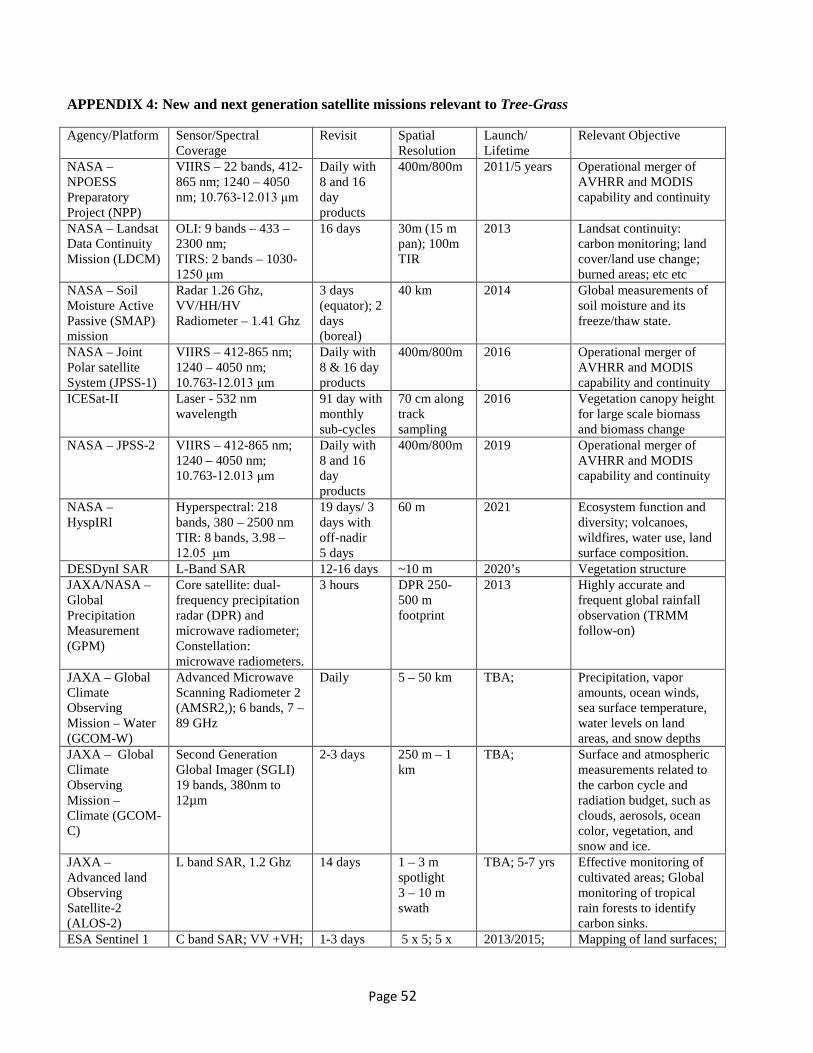
Page 52
APPENDIX 4: New and next generation satellite missions relevant to Tree-Grass
Agency/Platform Sensor/Spectral Coverage
Revisit Spatial Resolution
Launch/ Lifetime
Relevant Objective
NASA – NPOESS Preparatory Project (NPP)
VIIRS – 22 bands, 412-865 nm; 1240 – 4050 nm; 10.763-12.013 μm
Daily with 8 and 16 day products
400m/800m 2011/5 years Operational merger of AVHRR and MODIS capability and continuity
NASA – Landsat Data Continuity Mission (LDCM)
OLI: 9 bands – 433 – 2300 nm; TIRS: 2 bands – 1030- 1250 μm
16 days 30m (15 m pan); 100m TIR
2013 Landsat continuity: carbon monitoring; land cover/land use change; burned areas; etc etc
NASA – Soil Moisture Active Passive (SMAP) mission
Radar 1.26 Ghz, VV/HH/HV Radiometer – 1.41 Ghz
3 days (equator); 2 days (boreal)
40 km 2014 Global measurements of soil moisture and its freeze/thaw state.
NASA – Joint Polar satellite System (JPSS-1)
VIIRS – 412-865 nm; 1240 – 4050 nm; 10.763-12.013 μm
Daily with 8 & 16 day products
400m/800m 2016 Operational merger of AVHRR and MODIS capability and continuity
ICESat-II Laser - 532 nm wavelength
91 day with monthly sub-cycles
70 cm along track sampling
2016 Vegetation canopy height for large scale biomass and biomass change
NASA – JPSS-2 VIIRS – 412-865 nm; 1240 – 4050 nm; 10.763-12.013 μm
Daily with 8 and 16 day products
400m/800m 2019 Operational merger of AVHRR and MODIS capability and continuity
NASA – HyspIRI
Hyperspectral: 218 bands, 380 – 2500 nm TIR: 8 bands, 3.98 – 12.05 μm
19 days/ 3 days with off-nadir 5 days
60 m 2021 Ecosystem function and diversity; volcanoes, wildfires, water use, land surface composition.
DESDynI SAR L-Band SAR 12-16 days ~10 m 2020’s Vegetation structure JAXA/NASA – Global Precipitation Measurement (GPM)
Core satellite: dual-frequency precipitation radar (DPR) and microwave radiometer; Constellation: microwave radiometers.
3 hours DPR 250-500 m footprint
2013 Highly accurate and frequent global rainfall observation (TRMM follow-on)
JAXA – Global Climate Observing Mission – Water (GCOM-W)
Advanced Microwave Scanning Radiometer 2 (AMSR2,); 6 bands, 7 – 89 GHz
Daily 5 – 50 km TBA; Precipitation, vapor amounts, ocean winds, sea surface temperature, water levels on land areas, and snow depths
JAXA – Global Climate Observing Mission – Climate (GCOM-C)
Second Generation Global Imager (SGLI) 19 bands, 380nm to 12µm
2-3 days 250 m – 1 km
TBA; Surface and atmospheric measurements related to the carbon cycle and radiation budget, such as clouds, aerosols, ocean color, vegetation, and snow and ice.
JAXA – Advanced land Observing Satellite-2 (ALOS-2)
L band SAR, 1.2 Ghz 14 days 1 – 3 m spotlight 3 – 10 m swath
TBA; 5-7 yrs Effective monitoring of cultivated areas; Global monitoring of tropical rain forests to identify carbon sinks.
ESA Sentinel 1 C band SAR; VV +VH; 1-3 days 5 x 5; 5 x 2013/2015; Mapping of land surfaces;

Page 53
HH + HV. 20; 20 x 40; consumables for 12 years
forest, water and soil, agriculture
ESA Sentinel 2 13 bands: 443-2190 nm 5 days (with 2 satellites)
10, 20 and 60m
2013; consumables for 12 years
Land cover/use, change detection, vegetation properties
ESA Sentinel 3
OLCI-21 bands; 400 – 1020 nm. SLSTR-9 bands; 550 – 12000 nm. MWR-2 bands; 23.5/36.6 Ghz
27 day repeat
300 m 500 m/1 km
2013; consumables for 12 years
Land color (MERIS successor); Land surface temperature; In-land water; Vegetation products
DLR/ENMAP Consortium – Environmental Mapping and Analysis Program (ENMAP)
VNIR: 420 – 1000 nm SWIR: 900 – 2450 nm
4 days using off nadir pointing
30 m 2013: 5 years/ 25 years in lower orbit
Agricultural and forest management; hazard assessment; monitoring inland waters; dryland degradation; mineral exploration
INPE – China-Brazil Earth Resources Satellite series (CBERS 3/4)
PANMUX: 4 bands 510-890 nm MUXCAM: 450-890 nm IRMSS: 0.5-12.5 μm WFI: 450-890 nm
26 days 5 days 26 days 5 days
5 m 20m 40/80m 64m
2011/2013 Vegetation, agriculture, environment, water, geology and soil; surface temperature; regional and national mosaics; monitoring dynamic phenomena

Page 54
APPENDIX 5: SRS Mailing List
Name Affiliation Country Amiri, R. Monash U. Australia Anderson, D. USGS USA Anderson, M. Wake Forest U. USA Anyamba, A. GEST/NASA-GSFC USA
Armston, J. Env. & Resource Manag. Australia
Armston, J. U. Queensland Australia Balzter, H. U. Leicester UK Barroso, M. WWF Brazil Baumgarten, L. TNC Bayma Siqueira Silva, G. Embrapa Brazil
Beringer, J. Monash U. Australia Blanco, L. INTA EEA La Rioja Argentina Blaum, N. U. Potsdam Germany Boggs, G. Charles Darwin U. Australia Brannstrom, C. Texas A&M U. USA Briggs, J. KSU-Konza USA Brown, M. NASA USA Browning, D. USDA-Jornada USA Bruna, E. U. Florida USA Bucini, G. Colorado State USA Cable, J. U. Alaska USA Campbell, P. UMBC & GSFC USA Cassells, G. U. Edinburgh UK Caylor, K. Princeton U. USA Chadwick, O. UC Santa Barbara USA
Chen, Q. U. Hawaii at Manoa USA
Chopping, M. Montclair State U. USA Chris, S. UC Santa Barbara USA Cook, B. NASA-GSFC USA Cook, G. CSIRO Australia Coughenour, M. Colorado State USA Czaplewski, R. US Forest Service USA de Beurs, K. Virginia Tech USA De Michele, C. - Italy Del Vecchio, R. ESSIC-UMD USA Didan, K. U. Arizona USA Dohn, J. Colorado State USA Dube, O. U. Botswana Botswana Dwyer, P. CSIR South Africa Dye, D. USGS USA Eamus, D. U. Tech. Sydney Australia
Name Affiliation Country
Etter, A. Universidad Javeriana Colombia
February, E. U. Cape Town South Africa Felderhof, L. Firescape Science Australia
Fernandez, L. Carnegie Institution, Global Ecology
USA
Ferreira, L. LAPIG - UFG Brazil Filippi, A. Texas A&M U. USA Fisher, J. U. Witwatersrand South Africa Galford, G. MBL-Ecosystems USA Gillieson, D. James Cook U. Australia Gonzalez Roglich, M. Duke U. USA
Griffith, D. Wake Forest USA Griffith, P. NASA GSFC USA Gwenzi, D. Colorado State U. USA Hanan, N. Colorado State U. USA Hansen, M. SD State U. USA Hao, W. US Forest Service USA Herrmann, S. - USA Hodkinson, D. NASA GSFC USA Huang, C. National Taiwan U. Taiwan Huber, D. Colorado State U. USA
Huete, A. U. Arizona/ U. Tech. Sydney Australia
Jeltsch, F. U. Potsdam Germany Joern, A. Kansas State U. USA Justus, F. Doctoral Student USA Karfs, R. Queenland Australia
Kastdalen, L. Norwegian Space Centre Norway
Keller, M. NEON USA Khalefa, E. U. Leicester UK Kleyn, L. U. Witwatersrand South Africa Knox, N. ITC Netherlands Kooiman, A. ITC Netherlands Kusserow, H. FU Berlin Germany Kutt, A. CSIRO Australia Langstroth, R. ERM, Inc, Denmark Lavender, S. ARGANS Ltd UK Lefsky, M. Colorado State U. USA
Levick, S. Carnegie Institution USA
Li, Y. - China

Page 55
Name Affiliation Country Lu, L. Colorado State U. USA Luck, W. CSIR South Africa Ma, X. U. Tech Sydney Australia Maier, S. Charles Darwin U. Australia Malanding, J. CIESIN at Columbia USA Marais, E. Harvard U. USA Marsh, S. U. Arizona USA
Martins, I. National Institute of Space Research Brazil
Mathew, T. Independent Researcher Mathieu, R. CSIR South Africa McCarty, J. U. Louisville USA McDonald, K. Jet Propulson Lab USA Miguel, R. NASA USA Miller, J. NOAA/UC Boulder USA Mishra, n. U. Texas USA Mitchard, E. U. Edinburgh UK Morgan, J. La Trobe U. Australia Morisette, J. USGS-Fort Collins USA Munger, J. Harvard U., SEAS USA Munzimi, Y. SD State U. USA
Nangendo, G. Wildlife Conservation Society
Netherlands
Neuenschwander, A. U. Texas USA
Nickeson, J. NASA-GSFC USA Nippert, J. Kansas State U. USA Nwankwo, L. U. Ilorin, Nigeria Nigeria Ojima, D. Colorado State U. USA ONeal, K. U. Maryland USA Owen-Smith, N. U. Witwatersrand South Africa Palace, M. U. New Hampshire USA Parrini, F. U. Witwatersrand South Africa Parrini, F. U. Witwatersrand South Africa
Peinetti, R. U. Nacional de La Pampa Argentina
Pereira, A. INPE Brazil Perkins, G. CSIRO Australia Petroy, S. Ball Aerospace USA Pinto, F. INPA Brazil Popescu, S. Texas A&M U. USA Potter, C. NASA USA
Poulter, B. Swiss Federal Research Institute Switzerland
Name Affiliation Country Powell, R. U. Denver USA Powell, S. Montana State U. USA Qin, Y. - Quaife, T. U. Exeter UK
Radeloff, V. U. Wisconsin-Madison USA
Rahman, F. Indiana Univeristy USA Ramond, T. Ball Aerospace USA Reyes Acosta, L. ITC Netherlands Ribeiro, N. Mondlane U. Mozambique Russell-smith, J. Bushfires NT Australia Ryan, C. U. Edinburgh UK Sahoo, A. Princeton U. USA Sankey, T. Idaho State U. USA Santos Vega, M. DNP Colombia
Scarth, P. Queensland Government Australia
Schaaf, C. Boston U. USA Schnase, J. NASA-GSFC USA Schneider, L. Rutgers U. USA Sendabo, D. Ethiopian Mapping Ethiopia Serbin, G. ASRC USA Silva, G. INPE Brazil Silvius, K. Moore Foundation USA Singh, K. IIT Mumbai India Skidmore, A. ITC Netherlands
Smit, I. South African National Parks South Africa
Smith, A. U. Idaho USA Solorzano, A. U. Brasilia Brazil Southworth, j. U. florida USA Stuart, N. U. Edinburgh UK
Swemmer, T. South African Environmental Observation
South Africa
Swenson, J. Duke U. USA
Theron, L. Peace Parks Foundation Zambia
Thielen, D. IVIC Venezuela Tieszen, L. USGS-EROS USA Torbick, N. AGS USA Tredennick, A. Colorado State U. USA Treydte, A. U. Hohenheim Germany Trodd, N. Coventry U. UK Turner-Valle, J. Ball Aerospace USA

Page 56
Name Affiliation Country Vadrevu, k. Ohio State U. USA Van Langevelde, F. Wageningen U. Netherlands
Vargas, R. UC Berkeley USA Vollrath, A. FSU Jena Germany von maltitz, G. CSIR South Africa Wallace, J. CSIRO Australia Washington-Allen, R. Texas A&M U. USA
Weber, K. Idaho State U. USA Wiegand, K. U. Goettingen Germany Williams, C. Clark U. USA Wofsy, S. Harvard U USA Woodhouse, I. The U. Edinburgh UK Worden, J. ACC/ILRI Kenya Xiao, J. U. New Hampshire USA Xie, H. UT San Antonio USA Yager, K. NASA Goddard USA Yates, C. Bushfires NT Australia
Young, T. UC Davis; Mpala Research Centre USA
Zhang, X. NOAA USA Zhengpeng, L. USGS-EROS USA