sync user guide - dta0yqvfnusiq.cloudfront.net file1. about this guide! ! ! ! ! ! ! 1.1! thank you...
TRANSCRIPT

1
Synchronize User GuideReal-Time GPS Tracking System

TABLE OF CONTENTS1.! ABOUT THIS GUIDE ...........................................................................................................................!3! 1.1! THANK YOU .............................................................................................................................!3! 1.2! CONTACT INFORMATION .......................................................................................................!3
2.! KEY FEATURES ..................................................................................................................................!4! 2.1! ENVIRONMENT ........................................................................................................................ !4! 2.2! SYNCHRONIZE DATA PLAN OPTIONS ......................................................................... . . . . . . . !4! 2.3! SILVERCLOUD ONLINE SOFTWARE FEATURES ...................................................................!5
3.! ACTIVATING THE SYNCHRONIZE .....................................................................................................!....6
4.! INSTALLING THE SYNCHRONIZE .....................................................................................................!7! 4.1! INSTALLING THE SYNCHRONIZE SYSTEM...........................................................................!7! 4.2! STARTING THE SYSTEM .........................................................................................................!9! 4.3! LOGGING OUT OF THE SYSTEM ...........................................................................................!10! 4.4! LIVE SUPPORT CHAT ..............................................................................................................!10
5.! STEP-BY-STEP INSTRUCTIONS ........................................................................................................!11! 5.1! THE SILVERCLOUD CONTROL PANEL ..................................................................................!11! 5.2! THE SILVERCLOUD MAIN MENU ...........................................................................................!11! 5.3! THE SILVERCLOUD MAIN MENU SELECTIONS ....................................................................!12! ! 5.3.1! HISTORICAL PLAYBACK .......................................................................................... !12! ! 5.3.2! DEVICE EDITOR ........................................................................................................!13! ! 5.3.3! GROUP EDITOR ........................................................................................................!13! ! 5.3.4! SETTING GEOFENCE ALERTS .................................................................................!13! ! 5.3.5! SETTING PROXIMITY ALERTS .................................................................................!15! ! 5.3.6 ! ROUTING UTILITY .....................................................................................................!15! ! 5.3.7! NEAREST VEHICLE ROUTING UTILITY ...................................................................!16! 5.4! SILVERCLOUD SHARESPOT® FEATURE ...............................................................................!17! 5.5! PROGRAM SETTINGS .............................................................................................................!18
6.! REPORTS ............................................................................................................................................!19! 6.1! GENERATING REPORTS .........................................................................................................!19! 6.2! REPORT TYPES .......................................................................................................................!20! ! 6.2.1! CURRENT STATUS REPORT .................................................................................... !20! ! 6.2.2! ACTIVITY SUMMARY REPORT ................................................................................ !20! ! 6.2.3! EXCESSIVE SPEED REPORT ................................................................................... !20! ! 6.2.4! COMPLETE ACTIVITY BY DEVICE REPORT............................................................ !20! ! 6.2.5! STOPS AND MILEAGE REPORT .............................................................................. !21! ! 6.2.6 ! MILEAGE BY STATE REPORT .................................................................................. !21! ! 6.2.7! ALARMS BY DEVICE REPORT ................................................................................ !21
7.! GEOLOCATION-HOW ADDRESSES ARE DEFINED ..........................................................................!22
8.! SPECIFICATIONS ................................................................................................................................!23
2

1. About this Guide! ! ! ! ! ! !
1.1! Thank You
First of all, we at LandAirSea Systems want to thank you for purchasing the SYNCHRONIZE Real-Time GPS Tracking System with On-Board Diagnostics. The SYNCHRONIZE incorpo-rates a powerful internal GPS and cellular module capable of transmitting location updates as fast as once every 3 seconds. This features makes it one of the fastest real-time GPS tracking devices on the market today. The web-based SYNCHRONIZE Online mapping software has also been developed to provide a truly user-friendly tracking experience.
This guide has been designed to provide step-by-step instructions on how to successfully install, activate and utilize the SYNCHRONIZE GPS Tracking System.
1.2! Contact Information
LandAirSea Systems, Inc. 2040 Dillard CourtWoodstock, IL 60098P: 847-462-8100 F: [email protected].
3
2. Key Features! ! ! ! ! ! ! !
2.1! Environment
• The SilverCloud® Online mapping software can be used on any PC or Macintosh with a high speed internet connection and an internet browser. The interface is compatible with all web-browsers, including Google Chrome, Safari, Firefox and Internet Explorer.
• Users can also access the SilverCloud® online mapping interface on their smartphones or mobile tablets (iOS and Android) by downloading the SYNCHRONIZE Mobile App from the iTunes Store or Google Play Store.
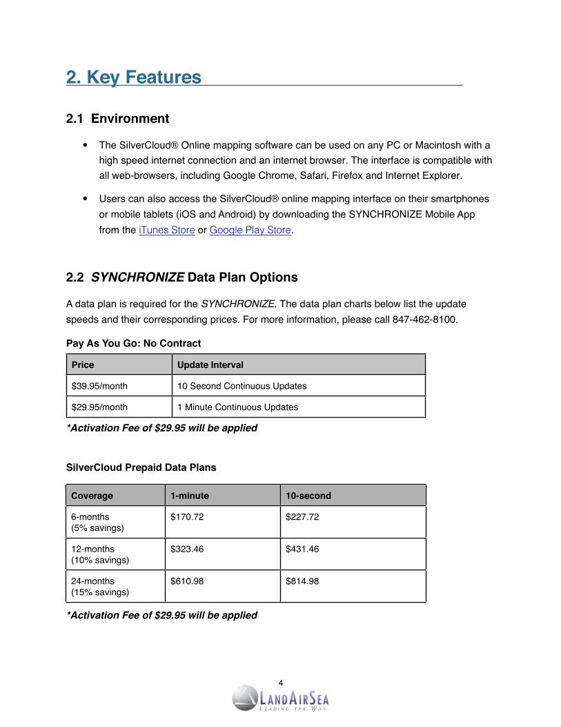
2.2! SYNCHRONIZE Data Plan Options
A data plan is required for the SYNCHRONIZE. The data plan charts below list the update speeds and their corresponding prices. For more information, please call 847-462-8100.
Pay As You Go: No Contract
Price Update Interval
$39.95/month 10 Second Continuous Updates
$29.95/month 1 Minute Continuous Updates
*Activation Fee of $29.95 will be applied
SilverCloud Prepaid Data Plans
*Activation Fee of $29.95 will be applied
4
Coverage 1-minute 10-second
6-months(5% savings)
$170.72 $227.72
12-months(10% savings)
$323.46 $431.46
24-months(15% savings)
$610.98 $814.98

2.3! SilverCloud Online Software Features
Mapping Interface Fast and user-friendly web-browser based application with up to date, simultaneous 2D and 3D mapping capabilities powered by Google Maps
ShareSpot® Patent-pending features, allows the user to share their GPS location via URL address or embedded code on a website
Geo-Fencing Option Allows users to create customized zones that can send text messages (SMS) and/or emails notifying the user when the vehicle enters or exits that zone
Traffic Information Ability to indicate traffic and delays on the map by utilizing existing Google Maps traffic flow interface
Routing Utility Offers users the ability to send real-time directions to driver’s mobile phone via text message (SMS) and/or email
Historical Location Data Ability to view unlimited real-time GPS tracking and data, with web-based historical playback as well as the ability to generate printable text reports
SilverCloud Alerts Indicates speed, low-battery, excessive/unnecessary stops, arrival and departure notifications via text message (SMS) and/or email
5

3. Activating The SYNCHRONIZE! ! !
In order to activate your SYNCHRONIZE, please go to www.landairsea.com and click on the online activation link, which is located near the upper right of the home page. This online form needs to be completed in full. Incomplete or missing information may delay the activation process.
The credit card on file will be billed automatically each month. Upon completing the activation form, the user will be charged the $ 29.95 activation fee and the pro-rated balance of the current monthly service. The next bill will not be due until the next full month. If a device becomes deactivated, a reactivation fee of $ 29.95 will be charged in order to restart service.
In order to cancel a data plan service, the user must do so in writing. This can be done by email and sent to: [email protected] .
Cancelations must be received prior to the close of the last business day of the month to avoid the next billing cycle. LandAirSea Systems is not open on weekends, and so, cancelations must be performed before the last business day of the month. For questions about activation, please call 847-462-8100.
To retrieve a lost password, add, delete or change a password(s) for an account, please contact [email protected] or call 847-462-8100. The user will be required to provide their addresson file, as well as the serial number, which is located on the bottom of the device.
6

4. Installing the SYNCHRONIZE! ! !
4.1! Installing the SYNCHRONIZE System
Users will need to activate (Section 3) their SYNCHRONIZE unit(s) first before starting the system. Users will also need to install the Google Earth® plugin on their computer (PC and/or Mac). The Google Earth plugin will allow users to access the functionalities of Google Earth without having to install the full application. To download and install the plugin, go to: www.earth.google.com/plugin.
After activating the SYNCHRONIZE unit(s), take the device and plug it into the vehicle’s OBD-II Port, which is usually located under the driver's side dash or steering column/instrument cluster (refer to the vehicle’s owner’s manual or go to the follow website:http://www.canobd2.com/TechInfo/DlcLocator.aspx).
The On-Board Diagnostic (OBD-II) specification has been a standard of all vehicles sold in the United States since 1996. The OBD-II port was designed to help technicians diagnose and troubleshoot a vehicle’s malfunctions. a standard place it outdoors.
The SYNCHRONIZE receives power through the OBD port - no batteries or hardwiring necessary. This allows for uninterrupted GPS tracking whenever the SYNCHRONIZE is connected to the vehicle’s OBD-II port.
7
16 Pin OBD-II Connector With SYNCHRONIZE
Common Location for OBD-II Port

8
LED Indicator LampsLED Indicator LampsLED Indicator LampsLED Indicator Lamps
Condition Red LED OBD Green LED GSM Blue LED GPS
Initial Power Cycle Fast Blink
Power/Protocol Discovered Slow Blink
Searching for Cell Signal Fast Blink
Signal Found Transmitting Slow Blink
Acquiring Satellite Signal Fast Blink
Satellite Signal Acquired Solid
NOTE: The micro USB (2.0) connector is intended for troubleshooting and cannot be used to charge the device.
NOTE: The SYNCHRONIZE is NOT waterproof or water resistant device. Please ensure that the device is kept free from excessive dust and moisture.
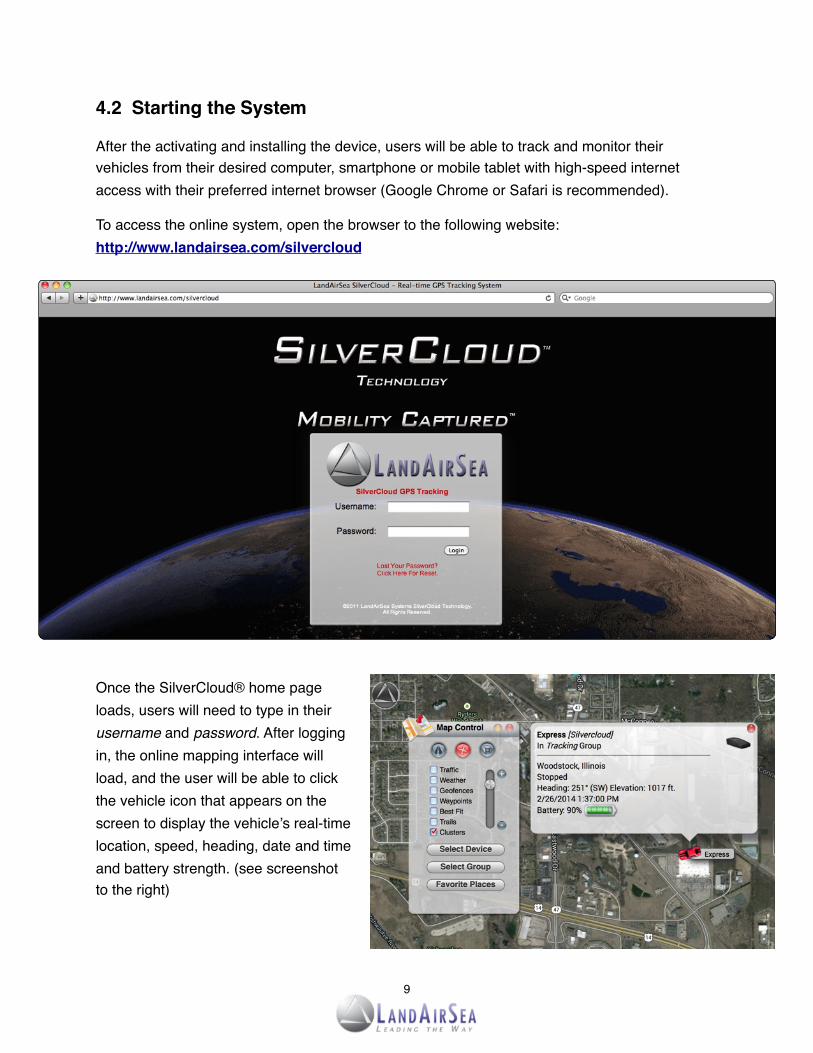
4.2! Starting the System
After the activating and installing the device, users will be able to track and monitor their vehicles from their desired computer, smartphone or mobile tablet with high-speed internet access with their preferred internet browser (Google Chrome or Safari is recommended).
To access the online system, open the browser to the following website: http://www.landairsea.com/silvercloud
Once the SilverCloud® home page loads, users will need to type in their username and password. After logging in, the online mapping interface will load, and the user will be able to click the vehicle icon that appears on the screen to display the vehicle’s real-time location, speed, heading, date and time and battery strength. (see screenshot to the right)
9

4.3 Logging Out of the System
To log out of the online mapping system, click on the LandAirSea logo located on the top left corner of the page to access the main menu. Once the main menu appears, select “Logout” located at the bottom of the menu.
Once the user is logged out, the browser will automatically load to LandAirSea’s home page (www.landairsea.com).
4.4! Live Support Chat
SilverCloud users will also be able to chat live with a support representative by clicking Live Support Chat feature located in the Main Menu.
Choose the Live Support Chat option and the AliveChat Session window will open. Choose Tech Support or Sales, enter your name and question and click Submit. You will be connected to a Live Support Agent.
LandAirSea also offers 24/7 technical support by phone by calling 847-462-8100 or via email at [email protected].
Tech Support Page:http://www.landairsea.com/contact/support.php
10

5. Step-By-Step Instructions! ! ! ! !
5.1! The SYNCHRONIZE Control Panel
Once the SilverCloud online mapping interface loads, the Control Panel will automatically appear on the upper left corner of the screen.
From the Control Panel, users will be able to:
• Select preferred view:A. Displays Road MapB. Displays Aerial ViewC. Displays 3-D View
• Select which vehicle(s) they want to view on themap or select multiple vehicles based createdgroups (creating groups covered in next section).
• Display regional traffic, view predetermined virtualzones (“geofences”), navigational waypoints, adjustbest fit for multiple vehicles, and view vapor trails asthe vehicle moves along the map.
• Zoom in (+) and out (-) by dragging the button up and down.
5.2! The SYNCHRONIZE Main Menu
The SilverCloud Main Menu can be accessed by clicking on the LandAirSea icon located on the upper left corner of the screen. From the screen users will be able to:
• Generate Historical Playback and printable Reports.
• Edit and label icons for individual vehicles.
• Specify and label Groups for multiple vehicles.
• Set Speed, Battery, Proximity and Geofence Alerts.
• Determine and send best Routes/Directions.
• Manage Advanced user settings, includingShareSpot®.
11
A B C
5.3! The SYNCHRONIZE Main Menu Selections
This section will help users navigate through the individual selections found on the Main Menu.
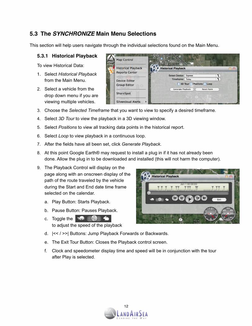
! 5.3.1! Historical Playback
! To view Historical Data:
1. Select Historical Playbackfrom the Main Menu.
2. Select a vehicle from thedrop down menu if you areviewing multiple vehicles.
3. Choose the Selected Timeframe that you want to view to specify a desired timeframe.
4. Select 3D Tour to view the playback in a 3D viewing window.
5. Select Positions to view all tracking data points in the historical report.
6. Select Loop to view playback in a continuous loop.
7. After the fields have all been set, click Generate Playback.
8. At this point Google Earth® may request to install a plug in if it has not already beendone. Allow the plug in to be downloaded and installed (this will not harm the computer).
9. The Playback Control will display on thepage along with an onscreen display of thepath of the route traveled by the vehicleduring the Start and End date time frameselected on the calendar.
a. Play Button: Starts Playback.
b. Pause Button: Pauses Playback.
c. Toggle theto adjust the speed of the playback
d. |<< / >>| Buttons: Jump Playback Forwards or Backwards.
e. The Exit Tour Button: Closes the Playback control screen.
f. Clock and speedometer display time and speed will be in conjunction with the tourafter Play is selected.
12

! 5.3.2! Device Editor
! From the Device Editor window users will be able to create a name label and choose an! icon for their vehicle(s), as well as set speed and low battery alarm notifications, which can! be sent to an email address and/or cell phone via text message (SMS).
1. To edit device name, choose the vehiclefrom the Device dropdown menu.
2. Designate a name for vehicle(s) in theLabel field. If a group has been created,choose that group in the group field.
3. Users will also be able to apply an Icon tothe vehicle in the Icon field.
4. Choose Save Device Info and the changes will display when you click the vehicle icon.
! 5.3.3! Group Editor
! Creating groups can be useful when needing to view multiple vehicles, but not necessarilyall vehicles.
1. To create a new group, type the name ofthe group in the Name field.
2. Then choose the vehicle which you wouldlike assigned to the new group from the[all vehicles] dropdown menu.
3. Choose Save and a new group will becreated with the vehicle within that group.
5.3.4! Setting Geo-Fence Alerts
! A geo-fence is a virtual boundary, or zone, createdaround a physical geographical space. TheSilverCloud’s online mapping interface has the Geo-Fence Alerts feature, which allows the user to sendemail and/or text message (SMS) notificationswhenever a vehicle either enters or exits adesignated area.
To create a Geo-Fence Alert:
1. Select SilverCloud Alerts from the Main Menu, andthen select the Geofence Alerts option.
2. Once the Geofence Alerts window opens, click on the Draw New Region button.
13

3. Choose whether the region is to be defined by an Oval or Rectangle, and then designate a desired color (red, yellow, blue, green, etc.).
4. Give the region a name by inserting the chosen name in the Name field.
5. Specify which unit or vehicle to designate for the alerts from the Device dropdown menu.
6. Define the time span for which the notifications will be sent in Start Time and End Time.
7. Choose Alarm on Entry or Alarm on Exit from the region or both by checking the corresponding box next to those fields.
8. Enter the email address and/or cell phone number to which notifications will be sent.
9. Enter a message to be sent to the recipient you want to display in Custom Msg field.
10. Click and drag the geofence (oval or rectangle) to the desired position on the map.
11. Click and drag to adjust the size of the geofence.
12. Once the geofence has been designated and the user is satisfied with the location and size of the alert, click on the Save Alarm Region button.
13. Users will now be able to receive notifications either through email or cell phone or both.
14. If users would like to make changes to the email or phone notifications, or move or resize the Alarm Region, reopen the Geofence Alerts screen from the Main Menu and click the named region in the upper left hand window. Make any changes necessary and choose Save Alarm Region.
14
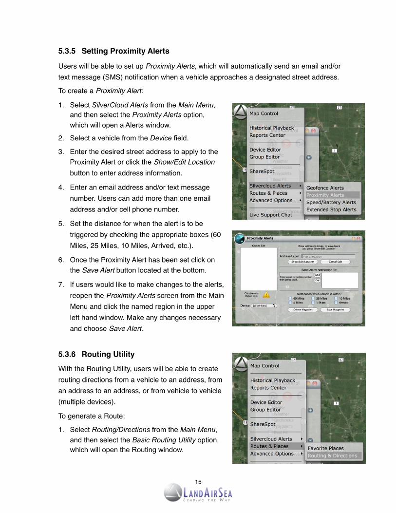
! 5.3.5! Setting Proximity Alerts
! Users will be able to set up Proximity Alerts, which will automatically send an email and/or ! text message (SMS) notification when a vehicle approaches a designated street address.
! To create a Proximity Alert:
1. Select SilverCloud Alerts from the Main Menu, and then select the Proximity Alerts option, which will open a Alerts window.
2. Select a vehicle from the Device field.
3. Enter the desired street address to apply to the Proximity Alert or click the Show/Edit Location button to enter address information.
4. Enter an email address and/or text message number. Users can add more than one email address and/or cell phone number.
5. Set the distance for when the alert is to be triggered by checking the appropriate boxes (60 Miles, 25 Miles, 10 Miles, Arrived, etc.).
6. Once the Proximity Alert has been set click on the Save Alert button located at the bottom.
7. If users would like to make changes to the alerts, reopen the Proximity Alerts screen from the Main Menu and click the named region in the upper left hand window. Make any changes necessary and choose Save Alert.
5.3.6! Routing Utility
! With the Routing Utility, users will be able to create ! routing directions from a vehicle to an address, from ! an address to an address, or from vehicle to vehicle ! (multiple devices).
! To generate a Route:
1. Select Routing/Directions from the Main Menu, and then select the Basic Routing Utility option, which will open the Routing window.
15

2. Select the From an Address box to route from an address or From a Vehicle box to routedirections from a vehicle. If routing from an address, type in the desired address in thefield, or select a desired vehicle from the dropdown menu.
3. Afterwards, select the To an Address box to route from an address or To a Vehicle box toroute directions from a vehicle. If routing to an address, type in the desired address inthe field, or select a desired vehicle from the dropdown menu.
4. Users will have the option to select the Show Directions box or Avoid Toll Roads box.
5. Once the fields have been designated and set, click on the Calculate Route button,which will open another window with directions. Users will have the option to send therouting directions to an email or a cell phone number.
! 5.3.7! Nearest Vehicle Routing Utility
! The Nearest Vehicle Routing Utility screen is the! same as the Routing Utility screen with one! exception. If users are tracking multiple vehicles,! they can enter an address and then choose Find! Nearest Vehicle. The screen will return the name! of the nearest vehicle on the screen and display! its distance from the address point.
16

Copy and paste site link for shared viewing.
Copy HTML code onto your website, blog or Facebook page to create a tracking window on a business or personal site for shared viewing.
5.4! SYNCHRONIZE ShareSpot® Feature
The patent-pending ShareSpot® is one of the innovative features offered by LandAirSea’s real-time GPS tracking systems. With the ShareSpot®, users of the SilverCloud and SYNCHRONIZE will be able to share their precise GPS location online in real-time. The shared online mapping window not only shows where the vehicle is, it also shows where it’s going and how fast it’s traveling. This allows the public to conveniently identify where the vehicle is at any time on a web-browser without having to contact the user directly.
To utilize ShareSpot®:1. Select Advanced Options from the Main Menu, and then
select the ShareSpot® option, which will open a new window.
2. Once the ShareSpot® window opens, owners of the SilverCloud or SYNCHRONIZE tracking systems will be able to share the real-time GPS location by sending a URL link via email, or by copying the automatically generated HTML code and embedding it onto a website or Facebook page.
Once embedded onto the website, the online mapping window automatically refreshes the GPS location, with continuous updates as fast as every 3 seconds based on the data plan and device chosen. Owners will also be able to share their GPS tracking data without having to compromise their username and password.
17

5.5! Program Settings
The SilverCloud online interface also offers the user complete account control. The Program Settings management screen allows users to change their password when necessary for added security. In this section, users will also have the ability change their email address and set the desired timezone.
****Sub Account: For Security Reasons, Sub Accounts have been disabled. If users would like to enable Sub Account options, please contact LandAirSea.
Sub-accounts give users a way to manage permissions, create specific passwords for devices, and share public views.
18

6. Reports! ! ! ! ! ! ! ! ! !
6.1!Generating Reports
From the Reports Screen, the user will have the ability to generate a number of detailed historical reports, which can then be viewed in a browser or Adobe PDF format. The reports can then be printed out for offline viewing or for filing/accounting purposes.
To generate a Report:
1. Select Report Center from the Main Menu, which will then open a new window.
2. Select the Create HTML box to view the report from a web browser.
3. Select the Create PDF box to generate a file that can viewed with Adobe Reader. Users will need to download and install Adobe Reader if it is not already a program on your computer. Adobe Reader can be downloaded by click on this link: http://get.adobe.com/reader/
4. Once the method of reporting has been determined, select the Report Type from the dropdown menu located at the top of the Report Center window.
5. Click the Generate Report button.
19

6.2! Report Types
! 6.2.1 Current Status Report
! The Current Status Report displays the most current status of the vehicle(s), including ! battery life, speed, last reported data point and last reported location.
! 6.2.2 Activity Summary Report
! The Activity Summary Report is a quick view of total daily mileage, travel time (runtime) and ! stops for the selected time period. Data is displayed on a Graph and on a Spreadsheet.
! 6.2.3 Excessive Speed Report
! Set the maximum acceptable speed for a vehicle and each instance that the vehicle ! exceeds the maximum speed for the selected time period will be displayed in the Excessive ! Speed Report.
! 6.2.4 Complete Activity by Device Report
! The Complete Activity by Device Report displays a graphical and spreadsheet of the time ! and speed for all positions reported for a selected time period. For each position reported to ! the server, the spreadsheet below the graph will display date/time, speed, heading and ! location. Alerts and Alarm notifications are also noted in the report. The street address in the ! location column is displayed as an active hyperlink street address which, when clicked, will ! open that location in Google Maps.
20

! 6.2.5 Stops and Mileage Report
! The Stops and Mileage Report is displayed in a spreadsheet format with Date/Time, Stop ! Description, Distance and Location columns.
• Description column displays the length of the stop.
• Distance column displays the distance traveled to the current stop from the last stop.
• Location displays a hyperlink street address that corresponds to latitude and longitude point. The location can be viewed in Google Maps by clicking the address.
6.2.6 Mileage by State Report
! The Mileage by State Report is displayed in a spreadsheet format with Date/Time,! Description, Runtime and State Location columns.
! 6.1.2.5 Alarms by Device Report
! If the user has already set up a SilverCloud alert, the number of alerts for the selected time ! period will be displayed in the Alarms by Device Report.
21

7. Geolocation - How addresses are defined!
Addresses for any GPS device are derived from a process called Reverse Geocoding. The device tracks a latitude and longitude geographic location and then derives an address based upon a database of addresses compiled by the government. The geographical coordinate is then mapped to the nearest known address. The nearest known address is an important concept here. Obviously it is virtually impossible to accurately pinpoint each latitude and longitude on the face of the earth so addresses may be off by a house or two, or may be an estimation of the address. Addresses are determined by lot numbers from the US census, so the returned address is only good as the database from which it is derived. This is true for every GPS device on the market today. All GPS devices use this same process. So...the device may be working properly and tracking all of the right locations, but the addresses might be off by a few numbers.
Our accuracy claims are based on geographic location on the earth, meaning the universal latitude and longitude coordinates. Most people, however, are accustomed to travel using a numbers-and-names address system. For that reason, all GPS devices on the market today utilize a process of converting latitude and longitude parameters to best known and available address.
Addresses are derived from a U.S. government database, based on census reports. The database is the best information available, but it is not perfect. The numbers can be off by a house or two, or the address might be an estimate, based on the data that is available.
Based purely on latitude and longitude pairings, LandAirSea Systems GPS tracking devices are among the most accurate you can buy.
22

8. Specifications! ! ! ! ! ! ! !
23
SilverCloud SpecificationsSilverCloud Specifications
Dimensions 2.28” W x 3.90” L x 0.90” H
Operating Temperature -40ºC to +85ºC (-40ºF to +185ºF)
Power Source 3.7 Volt, 1340 mAh rechargeable lithium-ion battery, wall charger and USB charger (optional: 12-volt cigarette lighter adapter and hardwire kit)
Typical Full-Power Current 150mA during transmission; less than 1mA at rest
GSM Channels 850/1900 (U.S.) 900/1800 (Europe, Australia, Asia, Middle East)
Communication Protocol TCP/UP, UDP, SMS
Update Frequency 1 minute, 10 second, 5 second and 3 second continuous updates
Antenna Quad-band GSM/GPRS and GPS, integrated into device.
Historical Playback Unlimited historical playback stored at LandAirSea’s server
Reporting Individual and enhanced vehicle report, start/stop, mileage and more
Notifications Virtual geo-boundaries and speed and battery alerts via SMS text message or e-mail.
SilverCloud® Sync SpecificationsSilverCloud® Sync Specifications
Dimensions 1.8” W x 2.18” L x 1.08” H
Operating Temperature -30ºC to +75ºC (-22ºF to +158ºF)
Power Source 9 - 16 Volts DC (powered by the vehicle’s OBD-II port)
Typical Full-Power Current 70mA at 12 Volts DC
GSM Channels 850/1900 (U.S.) 900/1800 (Europe, Australia, Asia, Middle East)
Communication Protocol SMS, GPRS (UDP)
Update Frequency 5 minute, 1 minute, 10 second and 5 second
Historical Playback Unlimited historical playback stored at LandAirSea’s server
Reporting Individual and enhanced vehicle report, start/stop, mileage and more
Diagnostics Blinking LED, SMS or TCP diagnostic messages