swjcs green belt review...swjcs green belt review july 2010 dns planning+design prepared by dns...
TRANSCRIPT

SWJCS GREEN BELT REVIEW
July 2010
dnsplanning+design
Prepared by DNS Planning and Design/ Nicholas Pearson Associates on behalf of SWJCS Team
Green Belt Review SWJCS Team SWJCS Area
DNS / NPA Date: 29 July 2010 Page 2
CONTENTS
1. Introduction ................................................................................................................... 6
2. Parameters of the Study ............................................................................................... 9
3. Methodology ............................................................................................................... 11
4. Planning Policy Considerations .................................................................................. 13
5. Green Belt Evolution in the Study Area ...................................................................... 24
6. Evaluation And Analysis ............................................................................................. 28
Definitions ................................................................................................................... 28
1. Area Between Stourport-On-Severn and A449 ...................................................... 31
2. Area Between A449 and M5 (Includes Cutnall Green) .......................................... 33
3. Area Between M5 and Littleworth; at the Boundary of the SWJCS Study Area .... 36
4. Area At North-Western Edge of SWJCS Study Area in the Vicinity of New End and Cookhill ............................................................................................................. 38
5. Area Between Droitwich Spa and Worcester ......................................................... 40
7. Conclusions and Recommendations .......................................................................... 45
FIGURES
Figure 1 Study Area
Figure 2 Aerial photograph showing residential development in the Green Belt at Impney Green, Droitwich Spa
Figure 3 Plan showing Green Belt boundary at Perdiswell, Worcester
APPENDICES
Appendix 1 Methodology
Appendix 2 PPG2 – Green Belts
Appendix 3 Land to the south and west of Worcester
Appendix 4 Development Plan Policies
Appendix 5 Letter to Planning Authorities from Secretary of State for Communities and Local Government dated 06 July 2010

Green Belt Review SWJCS Team SWJCS Area
DNS / NPA Date: 29 July 2010 Page 3
Executive Summary
A comprehensive review has been undertaken of the existing Green Belt, and adjoining land,
within the SWJCS area (see figure 1). This has appraised:
a. The history of Green Belt designation in the area as part of the wider West Midlands
Green Belt.
b. The existing Green Belt area against the purposes of PPG2.
c. The land adjoining the existing Green Belt as to whether these areas potentially fulfil
PPG2 purposes in the context of the wider strategic function of the West Midlands
Green Belt.
d. Land to the south and west of Worcester and north and north east of Malvern as to
whether these areas potentially fulfil PPG2 purposes in the context of the wider
strategic function of the West Midlands Green Belt.
e. Green Belt boundaries with regard to their definition and enduring qualities.
f. Identified recent development within the existing Green Belt and associated effects
upon the same.
g. Local exclusions („insets‟) from the Green Belt and changing circumstances.
Conclusions and Recommendations
1. The wider strategic Green Belt is long established. Its role has been to fulfil the
purposes of PPG2 in respect of the urban areas of the West Midlands conurbation,
which includes the urban settlements to the north of Worcester.
2. This report is concerned with the Green Belt within the SWJCS area. There have in
the past been small changes to the Green Belt comprising the exclusion of the Areas
of Development Restraint (ADRs) and also development within it. Notwithstanding
these alterations the fundamental extent, the overall area and importantly the
boundaries of the Green Belt have remained unaltered since its various designations.
3. The existing Green Belt within the SWJCS area is considered to fulfil the purposes of
PPG2. In this respect the designated areas are robust. Therefore, except for one
minor boundary realignment, see paragraphs 6.41, 6.45 and 7.4 below, it is not
Green Belt Review SWJCS Team SWJCS Area
DNS / NPA Date: 29 July 2010 Page 4
considered that the existing Green Belt should be modified in any other way either by
its extension or conversely by its reduction.
4. The only minor modification of the Green Belt which is recommended is at the
northern edge of Droitwich Spa at Impney Green (see figure 2) where a small area of
residential development has been implemented within the existing Green Belt and
where the Green Belt boundary would be more robust if it were now to define the
edge of and exclude this residential development area from the Green Belt.
5. The boundaries to the Green Belt are, in all but one instance, enduring and relate to
clearly defined features as set out in PPG2 paragraph 2.9. The exception is at
Perdiswell Leisure Centre where the Green Belt boundary is currently undefined on
the ground (see figure 3). Whilst this situation has been recognised by a previous
Local Plan Inspector, it is recommended that a clearly defined boundary, such as a
cycleway link as proposed in the City of Worcester Local Plan 1996 - 2011, is
identified on an appropriate proposals plan.
6. With regard to land adjoining existing Green Belt, PPG2 paragraph 2.8 states that a
boundary should be altered only in exceptional circumstances. It is not considered
that such exceptional circumstances exist with respect to land adjacent to the
Green Belt and so no additional areas of Green Belt are considered necessary, as
the strategic purposes of the Green Belt are variously fulfilled by its current
designation.
7. With regard to land to the south and west of Worcester and north and north east of
Malvern, there has been consistent recommendation from previous reviews that this
land should not be designated as Green Belt as it would constrain potential
requirements to accommodate the future development of Worcester. Before the
revocation of the Regional Strategy on 06 July 2010 by the Secretary of State, the
approach previously adopted when considering the question of expansion was most
recently reiterated in the Panel Report of the RSS Phase Two Revision published in
September 2009. In response to the proposed extension of the Green Belt around
Worcester, the Panel was not convinced that this would be justified. The Report
stated that imposing a Green Belt around Worcester would build in unnecessary
policy inflexibility into consideration of future needs or responding to infrastructure
needs. Notwithstanding the changes to the development plan, this approach to the
aforementioned area of Green Belt is still consistent with PPG2 paragraph 2.8 and
the need to establish Green Belt boundaries that will endure. It is recommended that
this land is not designated as Green Belt.

Green Belt Review SWJCS Team SWJCS Area
DNS / NPA Date: 29 July 2010 Page 5
8. Recent developments in the Green Belt have related to long term established uses
which are considered acceptable by the local planning authorities. It is not necessary
to exclude such uses and related site areas from the Green Belt.
9. Local exclusions (insets) are considered to be appropriate and no changes to existing
boundaries are necessary
10. There exists development in the Green Belt which has been consented since its
establishment and there are proposals for development within the existing
Green Belt. It is considered that any future development, unless it is demonstrated to
fulfil the requirements of very special circumstances as required in PPG2, would
result in change that would be detrimental to the existing Green Belt and its policy
objectives.

Green Belt Review SWJCS Team SWJCS Area
DNS / NPA Date: 29 July 2010 Page 6
1. INTRODUCTION
1.1 DNS Planning & Design, working in association with Nicholas Pearson Associates,
has been appointed by the South Worcestershire Joint Core Strategy (SWJCS)
team (Worcester City Council, Malvern District Council and Wychavon District
Council; which comprise the Local Planning Authorities (LPAs)) to undertake a
review of the Green Belt within the SWJCS area (see figure 1).
1.2 This study forms part of wider, ongoing work by the LPAs to deliver an evidence
base in support of the emerging SWJCS.
1.3 A review of the existing Green Belt, in particular the area between Droitwich Spa
and Worcester, is appropriate and necessary to inform the evidence base of the
emerging Joint Core Strategy.
1.4 This report does not provide a detailed appraisal of the land to the west and east of
Worcester, and south to Malvern, for Green Belt purposes. Rather reference is
made to the wider area in Appendix 3 which briefly discusses the principles of
potential additional Green Belt designation in such locations.
1.5 The scope of work therefore provides for a comprehensive review of the existing
Green Belt in the SWJCS area, which is contained within two of the three LPAs,
namely Worcester City and Wychavon District.
1.6 Specifically the brief is to:
i. Review the role and function of the Green Belt;
ii. Make an assessment as to whether the extent of the designated Green Belt is
still appropriate and justified;
iii. Review the existing Green Belt boundaries to assess whether they follow
readily recognisable and enduring features;
1.7 The Review addresses the existing Green Belt and its boundaries at the edges of
the larger urban centres of Worcester and Droitwich Spa and also in relation to the
larger villages either within or in close proximity to the existing Green Belt e.g.
Fernhill Heath; Wychbold and Hartlebury.
1.8 The Review also considers those areas immediately adjacent to existing Green Belt
which might be appropriate for inclusion within the Green Belt, as part of an
extension to it.
Green Belt Review SWJCS Team SWJCS Area
DNS / NPA Date: 29 July 2010 Page 7
1.9 PPG2 states that in paragraph 1.4 that, “the fundamental aim of Green Belt policy is
to prevent urban sprawl by keeping land permanently open; the most important
attribute of Green Belts is their openness”. Paragraph 1.6 advises that once Green
Belts have been defined, the use of land in them has a positive role to play in
fulfilling a number of objectives. Paragraph 1.7 makes it explicit that, not
withstanding these objectives, “the extent to which the use of land fulfils these
objectives is however not itself a material factor of the inclusion of land within a
Green belt or its continued protection for example, although Green Belts often
contain areas of attractive landscape, the quality of the landscape is not relevant to
the inclusion of land within a Green belt or to its continued protection. The purposes
of including land in Green belts are of paramount importance to their continued
protection, and should take precedence over the land use objectives.”
1.10 It is recognised that in particular locations there is development pressure on land in
the Green Belt. In certain locations as a result of settlement patterns the width of
the Green Belt cannot always be, in practicable terms, several miles wide.
Regardless of the size of the Green Belt, in such locations, the primary test is
whether it fulfils the purposes of the Green Belt and whether it continues to fulfil the
essential characteristics as defined in PPG2.
1.11 For the above reasons this Review does not place weighting or value on individual
parcels of land, whatever their size, within the Green Belt in terms of, for example,
sensitivity to change, specific landscape character or the ability of the wider Green
Belt to continue to function should areas on its inner or outer edge be removed from
the Green Belt. The review as advised by PPG2 focuses on the purposes of
including land in the Green Belt and the continued protection of the same. Matters
associated with landscape character, heritage, biodiversity and recreational
provision are covered by other documents including the Green Infrastructure Study.
1.12 The approach taken is informed by PPG2 paragraph 2.6 which addresses
boundaries and states that once the general extent of a Green Belt has been
approved it should be altered only in exceptional circumstances, and that detailed
Green Belt boundaries should be altered only exceptionally.
1.13 There are particular areas either on the boundaries of or within the Green Belt which
potentially will be promoted for development in the future. The study has found that
the Green Belt and associated boundaries fulfil their purposes and that there is no
reason to change the area covered by Green Belt or associated boundaries except
in one specific case. PPG2 paragraph 2.1 states that the essential characteristic of
Green Belt is their permanence. Their protection must be maintained as far as can
be seen ahead, and with specific respect to the boundaries they should be enduring.

Green Belt Review SWJCS Team SWJCS Area
DNS / NPA Date: 29 July 2010 Page 8
1.14 With respect to development, PPG2 states at 3.2 that, “inappropriate development
is, by definition harmful to the Green Belt. It is for the applicant to show why
permission should be granted”. Development is inappropriate unless it is for the
purposes as stated in paragraph 3.4 of PPG2.

Green Belt Review SWJCS Team SWJCS Area
DNS / NPA Date: 29 July 2010 Page 9
2. PARAMETERS OF THE STUDY
2.1 This report has been prepared in accordance with the SWJCS brief and is a review
of the existing Green Belt within the SWJCS area.
2.2 This report does not consider in detail the potential for creating additional substantial
Green Belt designations either around Worcester or between Worcester and
Great Malvern. The only consideration is to the desirability of designating land
immediately adjoining the existing boundary.
2.3 The potential for, and possibility of, larger and / or additional areas of Green Belt
designated land adjacent to or encircling Worcester has been variously proposed
since the introduction of Green Belt policy in 1955. The reasons for this have
included:
i. Local pressure to protect land from development;
ii. As a means of „compensating‟ for either removal of Green Belt designation
elsewhere (actual or proposed); and/or
iii. As means of compensating for the loss of green field sites to development.
2.4 The decision not to fully review the surrounding areas was based upon the following
reasons:
1. The methodology of this review is to appraise existing Green Belt and it is not
considered appropriate to apply the same approach for areas of
undesignated Green Belt land.
2. The proposal of additional Green Belt designated land would require clarity
on future boundaries. Given the uncertainty over future urban extensions
such appraisal work would be subject to review when proposed or actual new
urban boundaries had been established.
3. It is noted in the 1992 Green Belt plan that to extend the Green Belt beyond
the designated area, for example around the whole City, would conflict with
the express wishes of successive Secretaries of State when approving the
Worcestershire Structure Plan in 1975 and the Hereford & Worcester
Structure Plan in 1985 and 1990.
4. Prior to the revocation of the Regional Strategy on 06 July 2010 the Panel
Report to the RSS had specifically advised in paragraph 8.102 that the

Green Belt Review SWJCS Team SWJCS Area
DNS / NPA Date: 29 July 2010 Page 10
encirclement of Worcester by Green Belt would be inappropriate as it would
constrain the potential for sustainable future urban development and this is
material to the Green Belt Review.
2.5 In order for a study to assess whether other areas beyond the existing urban
boundary of Worcester (eg. to the east, south and west), or of other settlements,
meet the purposes of Green Belt, in accordance with PPG2, and if so whether such
land should be considered for potential designation as Green Belt it will therefore be
necessary either to:
a. Assess the area beyond the existing urban edge as if no such urban
extension is proposed, or;
b. Define a clear urban boundary, or boundaries, for such an extension beyond
which the land can then be tested against the purposes of PPG2, which are
set out in section 4 of this report.
2.6 This study does not take into account these potential major areas of planned growth
into the countryside, which are currently indicative only, because there is no
certainty of this change, and therefore no long term and enduring urban boundary
from which to assess any Green Belt definition. Appendix 3 deals with the principles
of potential additional Green Belt designation in such locations.

Green Belt Review SWJCS Team SWJCS Area
DNS / NPA Date: 29 July 2010 Page 11
3. METHODOLOGY
Best Practice
3.1 A review was undertaken of existing Green Belt reviews and appraisals to derive a
detailed methodology that utilises best practice and that is appropriate to the
SWJCS area. As part of this research a Green Belt history for Worcestershire has
been undertaken that chronicles the evolution of the current boundaries. Details of
the reports reviewed and derived methodology is set out in Appendix 1.
Methodology
3.2 The method of approach adopted is reported as follows:
Planning Policy Considerations:
3.3 Reviews the policy framework of the Development Plan in the SWJCS local
authorities with Green Belt designations and also considers other material policy
documents including Government Guidance in PPG2 – Green Belts.
The Green Belt Study Area:
3.4 Provides a context to the South Worcestershire Green Belt and deals with the
evolution of policy nationally and locally. It sets out the reasons for the original
Green Belt designations, and any subsequent amendments, including the rationale
of the Green Belt boundary in each instance (eg. M5, other roads, and railway
lines), as relating to the three constituent local authorities in South Worcestershire.
Evaluation and Analysis
3.5 Definitions: PPG2 elements are defined and include what constitutes “openness”
in Green Belt terms; whether Green Belt is required to fulfil more than one of the
purposes of PPG2; whether there is a minimum size for an area to be designated as
Green Belt; and how the existing Green Belt has been assessed in this study.
3.6 Study areas: The Green Belt has been divided into appropriate sub-areas to assist
in the evaluation and analysis process.
3.7 Changes: Identification of any major physical changes, including any substantial
new development, within the existing Green Belt since its various designations.

Green Belt Review SWJCS Team SWJCS Area
DNS / NPA Date: 29 July 2010 Page 12
3.8 The Five Green Belt Purposes: An appraisal of whether the existing Green Belt
(as located in both areas) fulfils its role in terms of the five purposes set out in
PPG2, as well an appraisal of the robustness of existing boundaries, by taking each
purpose in turn and assessing whether the criteria is still applicable.
3.9 Appraisal: From this, appraisal of the existing Green Belt in terms of land within it,
which might be considered for exclusion on the grounds that it no longer fulfils the
purposes of the Green Belt in terms of PPG2. This might include land on the urban
edges of the existing Green Belt which has been separated by the main body of the
Green Belt by reason of development. If any area of existing Green Belt were
recommended for such exclusion, undertake appraisal of the effects of such on the
integrity and function of the remaining Green Belt.
3.10 Consideration of the contextual land immediately adjacent to, and extending from,
the existing Green Belt in terms of:
i. Whether any such land would meet purposes of PPG2;
ii. The openness of the land in question and preservation of the same;
iii. The existence of elements which could provide a strong and enduring long
term boundary.
Conclusions and Recommendations
3.11 The final synthesis of this information has been presented in written form. Matrices
are not used as it is not considered that qualitative judgments can be given a
quantitative weighting or score for comparative purposes.
3.12 The Review makes independent recommendations about the future of the Green
Belt to the SWJCS team based on an evaluation of the findings and whether the
land continues to fulfil its purpose as Green Belt within the study area.

Green Belt Review SWJCS Team SWJCS Area
DNS / NPA Date: 29 July 2010 Page 13
4. PLANNING POLICY CONSIDERATIONS
Overview of Green Belt Policy
4.1 Following the establishment of the first „green belt‟ by the Greater London Regional
Planning Committee in 1935 the principle was enacted in the 1947 Town and
Country Planning Act which enabled local authorities to designate areas that should
be protected from development, including Green Belts, in their Development Plans.
4.2 The Ministry of Housing and Local Government gave advice to local authorities on
Green Belts in Circular (42/55) and stated that the three main functions of a
Green Belt should be:
i. to check the growth of a large built up area,
ii. to prevent neighbouring settlements from merging into another; or
iii. to preserve the special character of a town.
4.3 Further advice was set out in Circular 50/57 which established the principle of „white
land‟. This was land that, although not allocated for development could be
developed later without prejudicing the Green Belt.
4.4 A government publication in 1962, The Green Belts, gave more detailed advice on
the purpose of Green Belts. It emphasised the strict control of development and
that there should be a presumption against building, although development which
would not interfere with the open character of the land might be permissible. It
emphasized the recreational value of Green Belts and the need to maintain and
improve the landscape.
4.5 Circular 14/84 set out further advice, including the definition of detailed boundaries
in Local Plans. It states the essential characteristic of Green Belts is their
permanence and that boundaries should be altered only in exceptional
circumstances.
4.6 PPG2 - Green Belts was originally published in January 1988 and drawing on the
previous advice it explicitly extended the original purposes of the Green Belt to add:
to safeguard the surrounding countryside from further encroachment;
to assist in urban regeneration.

Green Belt Review SWJCS Team SWJCS Area
DNS / NPA Date: 29 July 2010 Page 14
4.7 The concept of Green Belts remains an important aspect of planning policy today
and the total area protected by Green Belts has increased by 25,000
square hectares since 1977 with a further 12,000 hectares due to be announced in
local authority plans. It is estimated that Green Belts now cover 13% of England.
4.8 It is stated in the Cambridgeshire Green Belt Review that although Green Belts are
widely held to be one of the most effective planning policies for protecting the
environment around cities, there are concerns about their impact and
appropriateness in effective spatial planning. Both the Royal Town Planning
Institute (RTPI) and the Town and Country Planning Association (TCPA) have called
for a review of Green Belt policy. While both organisations support Green Belts,
they considered an assessment should be carried out to determine how far they
could contribute to the achievement of the Government‟s objectives of sustainable
development. Additionally, both the RTPI and TCPA raise concerns about the
impact of Green Belt designation on the rural economy. Strict interpretations about
what development is considered appropriate is viewed as „unimaginative‟ and
„restrictive‟ and both organisations seek to promote more effective and positive land
uses in the Green Belt.
National Planning Policy - PPG2: Green Belts
4.9 Government Guidance on Green Belts is set out in PPG2. The current guidance
was published in January 1995 and amended in March 2001. Local planning
authorities must take into account PPG2 in preparing their Development Plans.
4.10 The Guidance states at paragraph 1.4 that the fundamental aim of Green Belt policy
is to prevent urban sprawl by keeping land permanently open; the most important
attribute of Green Belts is their openness. Green Belts can shape patterns of urban
development at sub-regional and regional scale, and help to ensure that
development occurs in locations allocated in Development Plans. They help to
protect the countryside, be it in agricultural, forestry or other use. They can assist in
moving towards more sustainable patterns of urban development.
4.11 Paragraphs 1.5 and 1.6 set out the five purposes of including land in the Green Belt
and the objectives of land use once the designation has been made.
4.12 The five purposes for including land are:
i. to check the unrestricted sprawl of large built-up areas;
ii. to prevent neighbouring towns from merging into one another;
iii. to assist in safeguarding the countryside from encroachment;

Green Belt Review SWJCS Team SWJCS Area
DNS / NPA Date: 29 July 2010 Page 15
iv. to preserve the setting and special character of historic towns; and
v. to assist in urban regeneration, by encouraging the recycling of derelict and
other urban land.
4.13 It is noted that PPG2 makes no reference as to whether one or more of the
purposes are to apply to any Green Belt area or whether any value or weighting can
be attributable to areas which „better‟ meet the purposes of the designation.
4.14 Within the Green Belt, land has a role to play in achieving the objectives set out
below. Paragraph 1.7 is considered to be important in that it states that the extent
to which the use of land fulfils these objectives is not itself a material factor in the
inclusion of land within a Green Belt, or in its continued protection. For example,
although Green Belts often contain areas of attractive landscape, the quality of the
landscape is not relevant to the inclusion of land within a Green Belt or to its
continued protection. The purposes of including land in Green Belts are of
paramount importance, and should take precedence over the following land use
objectives.
to provide opportunities for access to the open countryside for the urban
population;
to provide opportunities for outdoor sport and outdoor recreation near urban
areas;
to retain attractive landscapes, and enhance landscapes, near to where
people live;
to improve damaged and derelict land around towns;
to secure nature conservation interest; and
to retain land in agricultural, forestry and related uses.
4.15 In considering the designation of Green Belts the Guidance states that the essential
characteristic of Green Belts is their permanence and their protection must be
maintained as far as can be seen ahead, beyond the plan period to 2026.
4.16 When defining boundaries paragraph 2.6 states that once the general extent of a
Green Belt has been approved it should be altered only in exceptional
circumstances. If such an alteration is proposed the Secretary of State will wish to
be satisfied that the authority has considered opportunities for development within
the urban areas contained by and beyond the Green Belt. Similarly, detailed Green
Belt boundaries defined in adopted local plans or earlier approved Development

Green Belt Review SWJCS Team SWJCS Area
DNS / NPA Date: 29 July 2010 Page 16
Plans should be altered only exceptionally. Detailed boundaries should not be
altered or development allowed merely because the land has become derelict.
4.17 Paragraph 2.7 states that where existing local plans are being revised and updated,
existing Green Belt boundaries should not be changed unless alterations to the
Structure Plan have been approved, or other exceptional circumstances exist, which
necessitate such revision.
4.18 Where detailed Green Belt boundaries have not yet been defined paragraph 2.8
states that it is necessary to establish boundaries that will endure. They should be
carefully drawn so as not to include land which it is unnecessary to keep
permanently open. Otherwise there is a risk that encroachment on the Green Belt
may have to be allowed in order to accommodate future development. If boundaries
are drawn excessively tightly around existing built-up areas it may not be possible to
maintain the degree of permanence that Green Belts should have. This would
devalue the concept of the Green Belt and reduce the value of local plans in making
proper provision for necessary development in the future.
4.19 Paragraph 2.9 states that wherever practicable a Green Belt should be several
miles wide, so as to ensure an appreciable open zone all round the built-up area
concerned. Boundaries should be clearly defined, using readily recognisable
features such as roads, streams, belts of trees or woodland edges where possible.
Well-defined long-term Green Belt boundaries help to ensure the future agricultural,
recreational and amenity value of Green Belt land, whereas less secure boundaries
would make it more difficult for farmers and other landowners to maintain and
improve their land.
4.20 When drawing Green Belt boundaries in Development Plans local planning
authorities should take account of the need to promote sustainable patterns of
development. They should consider the consequences for sustainable development
(for example in terms of the effects on car travel) of channelling development
towards urban areas inside the inner Green Belt boundary, towards towns and
villages inset within the Green Belt, or towards locations beyond the outer Green
Belt boundary; paragraph 2.10.
4.21 Wychavon District Council has previously adopted a policy of development restraint
through Local Plan ADR allocations. Safeguarded land is addressed in PPG2 at
paragraphs 2.12, 2.13 and in Annex B, which provides guidance on identifying
safeguarded land and development control policies within it.
4.22 The guidance states that when local planning authorities prepare new or revised
structure and local plans, any proposals affecting Green Belts should be related to a
Green Belt Review SWJCS Team SWJCS Area
DNS / NPA Date: 29 July 2010 Page 17
time-scale which is longer than that normally adopted for other aspects of the plan.
They should satisfy themselves that Green Belt boundaries will not need to be
altered at the end of the plan period. In order to ensure protection of Green Belts
within this longer timescale, this will in some cases mean safeguarding land
between the urban area and the Green Belt which may be required to meet longer-
term development needs. Regional/strategic guidance should provide a strategic
framework for considering this issue.
4.23 In preparing and reviewing their Development Plans authorities should address the
possible need to provide safeguarded land. They should consider the broad
location of anticipated development beyond the plan period, its effects on urban
areas contained by the Green Belt and on areas beyond it, and its implications for
sustainable development. In non-metropolitan areas these questions should in the
first instance addressed in the structure plan, which should, where necessary,
indicate a general area where local plans should identify safeguarded land.
4.24 It is also worth clarifying that Green Belt policy is a planning designation. The issue
was raised in a Westminster Hall debate on 7 May 2008, where Iain Wright, Under
Secretary at DCLG, stated the Government position:
“Perhaps the key point in any discussion about green belt planning policy is to acknowledge that it is a planning designation, as opposed to some sort of assessment of the quality and biodiversity of the land. It was not intended or planned to be a nature or landscape conservation measure, although I fully recognise that biodiversity and the countryside benefit incidentally as a consequence of green belt designation. The objectives of green belt policy remain similar to what they always have been: to check the unplanned and unrestricted sprawl of developed areas, to prevent neighbouring towns and urban areas from merging into one another…..to assist in safeguarding the countryside from encroachment, and to preserve the special character of our historic towns. Another objective, which is often overlooked in discussion of green belt policy…is to assist in the regeneration of our urban communities by encouraging the recycling of derelict brownfield and other urban land. The intention is strategic. If any other designation is required on a particular stretch of land, such as a site of special scientific interest or an area of outstanding natural beauty…that designation and whatever protection it confers would be imposed on top of green belt status, which does not override or compromise them.”
Planning Policies Relating to the Green Belt Study Area
4.25 This section reviews the current planning policy framework affecting the SWJCS
Green Belt area. It has regard to the policies of the Development Plan and also to
emerging policy. The full policy text is set out in Appendix 4.
Green Belt Review SWJCS Team SWJCS Area
DNS / NPA Date: 29 July 2010 Page 18
The Development Plan
4.26 For the purposes of section 38(6) of the Planning and Compulsory Purchase
Act 2004 the Development Plan that covers the Green Belt study area includes:
Worcestershire County Structure Plan, 2001 (saved policies)
The Worcester City Local Plan, 2004 (saved policies)
The Wychavon District Local Plan, 2006 (saved policies)
The South Worcestershire Joint Core Strategy, Preferred Options –
September 2008
4.27 The LPAs will use the saved policies of the above Structure and Local Plans as the
starting point for development management decisions, including the determination
of planning applications, in accordance with s.38(6) having regard to all other
material considerations. This is the current policy basis applicable to the Green Belt
in the Study Area.
Revocation of Regional Spatial Strategy
4.28 On 6 July 2010 the Secretary of State1 announced the revocation of Regional
Strategies with immediate effect and confirmed that they no longer form part of the
development plan for the purposes of s.38(6).
4.29 The revocation of Regional Strategies was announced in a letter to local planning
authorities in England, dated 6 July 2010. This was accompanied by a guidance
note, which at point 22 addressed the question; whether the end of Regional
Strategies means changes to Green Belt? The guidance states that,
“The Government is committed to the protection of the Green Belt and the
revocation of Regional Strategies will prevent top-down pressure to reduce
the Green Belt protection. Local planning authorities should continue to apply
policies in PPG 2. As part of their preparation or revision of DPDs, planning
authorities should consider the desirability of new Green Belt or adjustment of
an existing Green Belt boundary, working with other local planning authorities
as appropriate.”
4.30 This Review of the Green Belt study area will inform the preparation of the SWJCS
Core Strategy and associated DPDs post the revocation of the Regional Strategy.
1 Secretary of State for Communities and Local Government

Green Belt Review SWJCS Team SWJCS Area
DNS / NPA Date: 29 July 2010 Page 19
4.31 Notwithstanding the revocation of the Regional Strategy the Review was prepared in
the context of the emerging revisions and these are material to the conclusions
drawn. This includes having regard to the comments made in the Panel Report that
a review of the existing Green Belt in south Worcestershire in the SWJCS area and,
in particular the area between Droitwich Spa and Worcester, is appropriate and
necessary to inform the evidence base of the emerging Core Strategy. Also that the
encirclement of Worcester by Green Belt would be inappropriate as it would
constrain the potential for sustainable future urban development.
Saved Worcestershire Structure Plan Policies
4.32 The Structure Plan covers the period 1996 to 2011. Under the provisions of the new
planning system it is being phased out but the Department of Communities & Local
Government has allowed Structure Plan polices to be “saved” for consideration until
2011.
4.33 The saved policies of the Structure Plan remain part of the statutory development
plan and will remain in place until they are superseded by the emerging SWJCS and
other DPDs.
4.34 The current supporting text to the Green Belt states that the environmental
character of the northern part of Worcestershire is in large measure due to the
presence of a Green Belt in the area. The control over development has restricted
the expansion of the larger towns and this in turn has helped to ensure that people
living in towns have easy access to nearby open countryside and outdoor recreation
areas as well as playing a part in conserving areas of landscape and agricultural
value. This is especially the case in the area to the north of the SWJCS area.
4.35 It is established that the main aims of the Green Belt in Worcestershire are focussed
on preventing the sprawl of the West Midlands Conurbation and preventing the
coalescence of settlements and acknowledges that this has generally been
achieved. These aims continue to be relevant in view of the continuing pressure for
development in the Green Belt.
4.36 The full policy text is set out in Appendix 4 and the reasoned justification is set out in
the adopted Structure Plan. The policies can be summarised as follows:
4.37 Policy D.12 - Housing in the Green Belt - will only be allowed in accordance with
the provisions of PPG2 where very special circumstances exist and it is for local
need.
4.38 Policy D.38 - General Extent and Purposes of the Green Belt - will be
maintained, with the purposes being to: check unrestricted sprawl of the

Green Belt Review SWJCS Team SWJCS Area
DNS / NPA Date: 29 July 2010 Page 20
conurbation; prevent the coalescence of settlements; safeguarding the countryside;
preserve historic towns; and assist in urban regeneration.
4.39 Policy D.39 - Control of Development in the Green Belt - a presumption against
inappropriate development as defined in PPG2 unless in the case of very special
circumstances which outweigh the harm to the Green Belt.
4.40 Policy D.40 - Green Belt Boundary Definition – where defining boundaries District
Councils should have regard to the purposes of the Green Belt set out in Policy
D.38 and the need to safeguard land for longer term development needs.
4.41 In relation to the SWJCS area the explanatory memorandum to the saved policies
states that within land designated as Green Belt there is a presumption against
inappropriate development in order to achieve the purposes of the Green Belt as set
out in Policy D.38. Inappropriate development is, by definition, harmful to the Green
Belt. The intention of Policy D.39 is not to replicate National Planning Policy
Guidance Note 2: Green Belts (1995) to which reference should be made. PPG2
indicates the types of development which are not inappropriate development in the
Green Belt. In summary these are: new buildings for the purposes of agriculture
and forestry; to provide essential facilities for outdoor sport and outdoor recreation,
for cemeteries and for other uses which preserve the openness of the Green Belt; a
limited extension alteration or replacement of existing dwellings; limited infilling in
existing villages and limited affordable housing for local community needs; limited
infilling or redevelopment of major existing developed sites identified in adopted
local plans; mineral extraction and other development which maintain the openness
of the Green Belt and do not conflict with the proposals of including land in the
Green Belt.
4.42 The issue of new housing in the Green Belt is addressed in Policy D.12 and it is
stated that in accordance with PPG2 not all forms of housing development is
inappropriate and may be acceptable in certain defined circumstances.
City of Worcester Local Development Framework
Saved City of Worcester Local Plan Policies
4.43 The South Worcestershire Joint Core Strategy is being prepared jointly by
Worcester City Council, Wychavon and Malvern Hills District Councils will not be
adopted before 2011. This will replace many policies within the County Structure
Plan and respective Local Plans and provide the principal guide for strategic
development. Other Development Plan Documents will be adopted thereafter in

Green Belt Review SWJCS Team SWJCS Area
DNS / NPA Date: 29 July 2010 Page 21
accordance with the programmes set out in the Local Development Schemes for the
respective Local Authorities.
4.44 Policy NE12 – Green Belt Area, of the City of Worcester Local Plan is a saved
policy.
4.45 The reasoned justification for the policies confirms that the Green Belt was first
defined for Worcester in the Green Belt Local Plan adopted in April 1992 and
confirms that once defined it should only be altered in exceptional circumstances.
The approach of the City Council is that there are no exceptional circumstances
which justify any incursion into the Green Belt.
4.46 The Local Plan is clear that the purpose of including land in the Green Belt around
the Claines area is to maintain its open character so as to prevent Droitwich Spa
and Worcester merging. To do this, it is important to prevent the built-up area of
Worcester from extending northwards. It is also important that the views of open
land from the roads and footpaths are maintained to preserve the generally open
nature of the area. In respect of this, the importance of this open area in
contributing to the setting and character of the historic city should be taken into
account. The policies are designed to serve this aim whilst also achieving other
objectives, such as allowing the requirements of agriculture to be met. The policies
are restricted to matters of specific Green Belt concern and do not, therefore, cover
all matters that are taken into account in making planning decisions including, for
example, the effect of the proposed development on traffic.
4.47 The full policy text is set out in Appendix 4 and the reasoned justification is set out in
the adopted Local Plan.
Wychavon Local Development Framework
Saved Wychavon Local Plan Policies
4.48 The Local Plan was adopted on 23 June 2006 and the saved policies include those
for the Green Belt.
4.49 The supporting text states that the areas of Green Belt land in the Wychavon District
are found to the north of Droitwich Spa and between Droitwich Spa; Worcester and
part of Redditch. The former has existed since the 1950s whilst the latter was
included as an extension in 1975. The land forms part of the wider West Midlands
Green Belt that surrounds the Birmingham conurbation and Coventry and serves to
prevent the unrestricted expansion of the conurbation, to prevent the coalescence of
towns and villages around it and to safeguard the countryside from encroachment
and to protect historic towns.

Green Belt Review SWJCS Team SWJCS Area
DNS / NPA Date: 29 July 2010 Page 22
4.50 It is stated that the protection of the Green Belt is an overriding planning
consideration and there is a presumption against inappropriate development within
it. Policy SR7 outlines the types of development considered by national planning
guidance PPG2 (Green Belt) to be appropriate within Green Belts. Appropriate land
uses are those which for the most part would retain the openness of the Green Belt.
Development that is necessary to the functioning of such land uses is also an
appropriate type of development in the Green Belt. However, it is still important that
the scale, location or design of buildings or structures does not impair the open
character of the Green Belt.
4.51 The Hartlebury Trading Estate is a Major Developed Site within the Green Belt and
Policy SR8 specifically deals with it, in accordance with the guidance given in PPG2
at Annex C. The policy recognises that the site presents opportunities to help
secure jobs and prosperity without further prejudicing the Green Belt designation. It
is stated that when applying Policy SR8, regard should be had to the defined
development footprint.
4.52 The full policy text is set out in Appendix 4 and the reasoned justification is set out in
the adopted Local Plan. The policies can be summarised as follows:
4.53 Policy SR7 - Development in the Green Belt – is limited so that it would not
detract from the open character of the Green Belt; or would not conflict with the
purposes of including land within it; and for the one of the listed uses including land
uses for the purposes of agriculture, forestry, outdoor sports and recreation, horse
riding, cemeteries and other uses suitable to the rural area and which preserve the
openness of land. Other small scale development involving the re-use or limited
infilling / extension in accordance with other Local Plan policies.
4.54 Policy SR8 - Major Developed Site in the Green Belt – Hartlebury Trading
Estate – regards this as being suitable for redevelopment and environmental
improvement under the provisions of PPG2 Annexe C and sets out the criteria for
development proposals, including having no greater impact than the existing
development on the openness of the Green Belt and the purposes of including land
within it, and where possible have less.
Areas of Development Restraint
4.55 The previous Local Plan identified areas of development restraint (ADR) within the
Green Belt to provide land for long-term development needs beyond the Plan
period, whilst not prejudicing the protection of the Green Belt.

Green Belt Review SWJCS Team SWJCS Area
DNS / NPA Date: 29 July 2010 Page 23
4.56 The identified ADRs, alongside the A38, in Wychavon are two at Droitwich Spa, one
at Fernhill Heath, two at Wychbold and one at Hartlebury. The Droitwich Spa ADRs
comprise a large greenfield site to the south of the main built-up area of the town
and a smaller area directly to the south-east of the urban area, abutting the M5.
The Local Plan Inspector considered the ADR sites to be those where new
development would contribute to minimising the need to travel and achieving
balanced communities.
4.57 The Local Plan states that the existing ADR land has been retained for this Plan
period to meet possible longer-term development needs beyond 2011. When
adopted the development strategy for the Local Plan did not require greenfield land
releases around Droitwich Spa to accommodate development within the period up
to 2011. As a result, the existing Green Belt boundary remains unchanged in this
Plan and the ADR land will be retained and will not be used to accommodate
development unless, and until it is required to do so in a future review of the housing
need and supply
4.58 Policy SR9 – Areas of Development Restraint - identifies land which will be
safeguarded and will not be released unless and until it is required for development
in a future review of the Local Plan.
Green Belt Review SWJCS Team SWJCS Area
DNS / NPA Date: 29 July 2010 Page 24
5. GREEN BELT EVOLUTION IN THE STUDY AREA
Background to the Worcestershire Green Belt
Context
5.1 The Green Belt land in the SWJCS area is found to the north of Droitwich Spa and
between Droitwich Spa and Worcester, and south of Redditch. The land forms part
of the wider West Midlands Green Belt that surrounds the Birmingham conurbation
and Coventry and serves to prevent the unrestricted expansion of the conurbation,
to prevent the coalescence of towns (such as Redditch, Stourport-on-Severn and
Bromsgrove, as well as Droitwich Spa and Worcester) and villages around it and to
safeguard the countryside from encroachment and to protect historic towns.
5.2 The broad expanse of Green Belt to the north of Droitwich Spa has existed since the
1950s whilst the land between Worcester and Droitwich Spa, which includes
Claines, Hindlip and Martin Hussingtree, was included as an extension in 1975.
History
5.3 The West Midlands Green Belt was created in the 1950s to restrain the outward
growth of the main built-up areas of Birmingham, Coventry and the Black Country,
and to protect the countryside in the adjacent counties of Shropshire, Staffordshire,
Warwickshire and Worcestershire. Within Worcestershire it also aimed to protect
and maintain the special character of towns such as Bromsgrove and Redditch.
5.4 In 1975 the Structure Plan for Worcestershire enlarged the extent of the Green Belt
in the county and included an area between Worcester and Droitwich Spa with the
intention of maintaining the open countryside between them and thereby preventing
their coalescence. The Structure Plan stated that to do this it is important to prevent
the built-up area of Worcester from extending northwards. Similarly it is also
important that the views of open land from the roads and footpaths are maintained
to preserve the generally open nature of the area. In respect of this, the importance
of this open area in contributing to the setting and character of the historic city
should be taken into account. The development control policies of the subsequent
Local Plans were designed to serve this aim whilst also achieving other objectives,
such as allowing the requirements of agriculture to be met.
5.5 In 1982 a proposed modification to the Structure Plan was put forward to extend the
Green Belt boundary westwards as far as the River Severn and the proposal were
subject to public consultation.

Green Belt Review SWJCS Team SWJCS Area
DNS / NPA Date: 29 July 2010 Page 25
5.6 In 1985 the Secretary of State (SoS) in the Notice of Approval for the Structure Plan
modified the key diagram so that the western boundary to the Green Belt was an
undefined line west of the railway line, which would be delineated in the Local Plan.
It was the view of the SoS at the time that the Green Belt between Droitwich Spa
and Worcester should not extend as far west as the River Severn. In relation to the
Fernhill Heath, the SoS Proposed Modifications allowed scope for the Green Belt to
take in the settlement itself but considered this to be a matter for the Wychavon
District Local Plan.
5.7 The County Council did commence work on a County Green Belt plan but this was
not adopted and the Districts undertook to prepare their own Local Plans for the
purpose of defining the Green Belt.
5.8 The 1992 City of Worcester Green Belt Local Plan was adopted and was in general
conformity with the Structure Plan and was only concerned with the area of open
countryside in the Claines and Blackpole area.
5.9 It is noted in the 1992 Green Belt plan that to extend the Green Belt beyond the
designated area, for example around the whole City, would conflict with the express
wishes of successive Secretary of States when approving the Worcestershire
Structure Plan in 1975 and the Hereford & Worcester Structure Plan in 1985 and
1990.
5.10 The extent of the Green Belt in the County has remained broadly the same since
1975 and the boundaries of the Green Belt in the SWJCS area have subsequently
been defined in detail in Local Plans.
Recent History
5.11 The adopted Local Plans for the City of Worcester and Wychavon now form part of
the Local Development Frameworks for the respective authorities and the current
Green Belt policies are set out in the planning policy chapter to this report.
Wychavon
5.12 The 2005 Inspector‟s Report to the Local Plan objections made general conclusions
on the plan strategy. In relation to the Green Belt the Inspector recommended at
[2.3.108 ix)] that there is no good case for allocating any land for development in the
Green Belt and that existing Green Belt boundaries should remain unaltered.
However in [2.3.109 x)] it was recommended that it was time to consider whether
the existing Areas of Development Restraint (ADRs) in the light of the emerging
West Midlands Regional Spatial Strategy should be retained, or deleted. The
Inspector noted at [2.13.7] that the ADRs all comprise greenfield land which falls

Green Belt Review SWJCS Team SWJCS Area
DNS / NPA Date: 29 July 2010 Page 26
between settlement boundaries and the defined Green Belt. They come within the
policy ambit of “safeguarded land”, described in PPG 2, paras.1.12-13 and Annex B.
It was stated that PPG2 does not require such areas of safeguarded land to be
defined, but it provides the policy justification for doing so in appropriate situations.
Having regard to the evidence at the Local Plan Inquiry the Inspector did not
recommend that any of the existing ADRs should be developed before 2011, or that
any new ADRs be identified.
5.13 Of all the objections made to the emerging Local Plan the Inspector only made one
recommendation for a very minor amendment to the Green Belt boundary at
Sling Lane in Fernhill Heath to, in effect, correct an anomaly in the boundary.
City of Worcester
5.14 The 2004 Inspector‟s Report to the Local Plan objections stated clearly that the
release of land in the Green Belt would not be supported.
5.15 In relation to the Green Belt area consideration was given to the following key
issues:
1. Whether the Green Belt boundary at Perdiswell was appropriately defined.
2. Whether the Green Belt designation north of Worcester and at the Moorlands
Riding Centre, Hindlip Lane, should be removed to open up development
opportunities.
3. Whether land between the A449 Ombersley Road in the west, the A38
Droitwich Road in the east and the A449 northern link road should be
excluded from the Green Belt.
4. Whether the corridor of land either side of the A38 Droitwich Road should be
excluded from the Green Belt.
5. Whether land lying between the A449 to the north, Blackpole Road to the
west and the Worcester and Birmingham Canal to the south and east should
be excluded from the Green Belt and allocated for employment development.
5.16 The Inspector recommended that no modification be made to the Local Plan as a
result of the objections forming the above key issues.
5.17 The comments of the Inspector in relation to delineation of the Green Belt boundary
at Perdiswell are of particular relevance to this review.

Green Belt Review SWJCS Team SWJCS Area
DNS / NPA Date: 29 July 2010 Page 27
5.18 Issue 1 concerns the delineation of the Green Belt boundary at the Perdiswell
Leisure Centre. It is stated at paragraph 3.14.3 that the City Council acknowledges
that the Green Belt boundary appears, on initial inspection, to have been drawn in
an arbitrary fashion. However, it is pointed out that the character of land to the
south of that line is protected by the Local Plan Green Network designation. The
planning authority considered it important that the future development of Perdiswell
for leisure and related purposes should not be prejudiced. The Inspector noted that
in this regard that the south-eastern area of the land is allocated for new Sub
Regional Indoor Sports Facilities under Policy CLT21. While the existing golf course
and sports pitches would comply with Green Belt policy, the planning authority says
there is a likelihood of substantial new buildings being required in the longer term.
Clearly, indoor facilities on such a large scale would not be compatible with the aim
of preserving the open character of the Green Belt.
5.19 At paragraph 3.14.4 the Inspector noted that the Perdiswell Sports Centre opened
as long ago as 1981 and agreed with the City Council that the Green Belt Local Plan
Inspector reporting in 1990 would have taken its location and potential for expansion
into account when he concluded that the Green Belt boundary as proposed then,
and now carried forward into the City of Worcester Local Plan 1996-2011,
represented an acceptable compromise. The Inspector did not consider it
necessarily to be an interim boundary. This view is reinforced by the Inspector‟s
remarks that the area included some existing development and land which it was
clearly not essential to keep permanently open. Since then an office development
centred on the listed building of Perdiswell Coach House and its walled garden,
Park and Ride facilities and other leisure uses have been implemented making it
even more inappropriate to extend the Green Belt boundary southwards to
Bilford Road.
5.20 The Inspector concluded that no exceptional circumstances have been
demonstrated to warrant an alteration to this section of Green Belt but did agree that
it would be desirable to have a Green Belt boundary physically demarcated by
existing landscape features. However, this is not feasible until such time as the
scope and extent of any new leisure uses in the area have been established. It was
noted that there was a Plan proposal for a cycle route across Perdiswell (see figure
3). When implemented that feature could provide the sort of definitive boundary
recommended by PPG2 that will be defensible and will endure. The Inspector felt it
appropriate, as part of a future Local Plan Review, to re-examine the Green Belt
boundary at that time and make any necessary detailed adjustments.
Green Belt Review SWJCS Team SWJCS Area
DNS / NPA Date: 29 July 2010 Page 28
6. EVALUATION AND ANALYSIS
Study Areas
6.1 The existing Green Belt has been divided into the following areas (see figure 1), for
the purposes of evaluation and analysis:
1. Area between Stourport-on-Severn and A449 (includes Hartlebury)
2. Area between A449 and M5 (includes Cutnell Green)
3. Area between M5 and Littleworth; at the boundary of the SWJCS jurisdiction
4. Area at north-western edge of SWJCS jurisdiction in the vicinity of New End
and Cookhill
5. Area between Droitwich Spa and Worcester.
6.2 Areas 1 – 3 are contiguous, located at the northern extent of the SWJCS area, with
open land beyond this, to the north, also designated as Green Belt with the
adjoining authorities (Redditch Borough Council, Bromsgrove District Council and
Wyre Forest District Council).
6.3 Area 4 is a small „pocket‟ of Green Belt designated land within the SWJCS area,
again which co-joins other Green Belt land to the north and east. Area 5 is a
separate area of Green Belt.
6.4 The types of Green Belt designated and non designated land that have been
appraised are:
Existing Green Belt Areas
„ Inset‟ islands of non Green Belt land within wider Green Belt
Land adjacent to existing Green Belt
DEFINITIONS
6.5 Having regard to the planning considerations set out above the following definitions
have been adopted in this report.

Green Belt Review SWJCS Team SWJCS Area
DNS / NPA Date: 29 July 2010 Page 29
Definition of Openness
6.6 The definition of openness has been variously tested at planning appeals. It is
generally understood to relate to land which is undeveloped in terms of built form
and engineering structures (including engineered landforms).
6.7 Openness, in terms of PPG2 policy, does not relate to the absence of vegetation
(eg. woodland or forestry), and hence the presence of such features does not
reduce „openness‟.
6.8 At the edges of Green Belt, especially at its „inner‟ boundary with the existing urban
area, development can and does have an influence on the openness of adjacent
Green Belt land. However such an effect is very likely, to varying degrees, to exist at
such inner boundaries, since it is the very nature of Green Belt designation that
boundaries can and are drawn tight to urban areas to enable the purposes of the
Green Belt to be met.
6.9 Consideration is made within the planning process of the effect of proposed new
development on the „openness‟ of existing Green Belt land, which might affect the
integrity of the Green Belt.
Fulfilment of more than one of the purposes of PPG2
6.10 Within PPG2 there is no indication or statement that land designated at Green Belt
need perform or fulfil more than one or conversely all the functions. Only at
paragraph 1.5, it simply states that „there are five purposes of including land in
Green Belts…‟ There is no judgement or guidance that land within the Green Belt
must fulfil several or a combination of functions and that one or more have greater
importance.
6.11 Indeed there are numerous occasions where Green Belt extends to an outer
boundary with the countryside, where no other settlement is within the general area,
and hence where it is impossible for the purpose „to prevent neighbouring towns
from merging into one another‟ to be met. In other instances, for example between
Worcester and Droitwich Spa four purposes of the Green Belt are met in its existing
designation. To reiterate, it is considered there is no requirement that more than one
function of the Green Belt to exist for land to successfully serve Green Belt
purposes.

Green Belt Review SWJCS Team SWJCS Area
DNS / NPA Date: 29 July 2010 Page 30
Minimum size for an area to be designated as Green Belt
6.12 PPG2 paragraph 2.9 states that „….wherever practicable a Green Belt should be
several miles wide, so as to ensure an appreciable open zone all round the built up
area concerned….‟
6.13 There is no other specific guidance on the size of Green Belts, other that a general
inference that Green Belt policy is a strategic planning instrument which might infer
that areas need to be of a large scale.
6.14 As such there is no absolute requirement for areas to be of a specific size before
Green Belt designation should be applied. However the term „appreciable‟ is noted
in that it infers that an element of visual judgment could be used to determine
whether an area of Green Belt is of sufficient size.
How the existing Green Belt has been assessed
6.15 The existing Green Belt has been assessed for the purposes of this study by a
qualitative rather than quantitative method, where the purposes of the Green Belt
are tested in respect of the land in question and professional judgments made as to
whether these are variously fulfilled. This has been undertaken by a comprehensive
site appraisal of the existing Green Belt, its boundaries and the land which lies
adjacent, as well an appreciation of the broader contextual area. This is reported in
words rather than using a scoring or weighting (eg. quantitative process), because
Green Belt cannot be usefully determined by such means.
6.16 PPG2 does not differentiate between the importance of one purpose over another
nor requires Green Belt to fulfil more than one or all criteria, and it is not considered
that this should be otherwise.
Boundaries
6.17 Boundaries of the existing Green Belt relate to the inner and outer edges as they
are defined by physical features, for example the urban edge, roads, canals and
railways.
Existing Green Belt Boundaries
6.18 PPG2 makes reference to what and how Green Belt boundaries should be
delineated. In paragraph 2.8 “…it is necessary to establish boundaries which will
endure…”; in paragraph 2.9 “… Boundaries should be clearly defined, using readily
recognisable features such as roads, streams, belts of trees or woodland edges
where possible.”
Green Belt Review SWJCS Team SWJCS Area
DNS / NPA Date: 29 July 2010 Page 31
6.19 The existing South Worcestershire Green Belt is delineated and bounded by various
features. These include roads, canals, urban edges and garden boundaries. This
review has identified all the boundaries and these are discussed below.
Control Over Development.
6.20 PPG2 establishes that inappropriate development is harmful to the Green Belt and
there is a presumption against it. The construction of new buildings in the Green
Belt is inappropriate unless it is for those purposes defined in paragraph 3.4 of
PPG2.
6.21 The guidance is clear that very special circumstances are required to justify
inappropriate development need and that it is for the applicant to demonstrate
grounds for permitting development. The presumption against inappropriate
development carries substantial material weight in terms of the harm to the Green
Belt in the determination of development proposals. Where existing Local Plans are
being revised and updated, existing Green Belt boundaries should not be changed
unless alterations to strategic policy have been approved, or other exceptional
circumstances exist, which necessitate such a revision. It is a matter for the
decision maker to decide whether the need for development within the Green Belt
carries sufficient material weight to be considered as very special circumstances to
permit otherwise inappropriate development, or whether there exist exceptional
circumstances that warrant a change to the Green Belt boundary, both as contrary
to the objectives of PPG2.
1. Area between Stourport-on-Severn and A449
Description
6.22 This area generally comprises open land to the east of Stourport, and includes a
number of scattered hamlets and farms including Leapgate, Charlton and Titton,
which are „washed over‟ by the Green Belt designation. To the immediate east of
Stourport lies Hartlebury Common, an area of public open space.
6.23 The western Green Belt boundary is drawn tight to the urban edge (residential
properties/ garden boundaries) of Stourport – western edge of Hartlebury Common,
and follows the administrative boundary northwards. At the northern edge, an area
of industrial/ engineering/ employment land (Summerfield Research Employment
Site, Summerfield Lane) is a protected employment site (Local Plan Policy ECON1),
washed over by Green Belt (PPG2 – Annex C).
6.24 The southern Green Belt boundary is drawn tight to the edge of the industrial estate
at Sandy Lane to the south of the A4025 (Stourport Road). Moving eastwards the

Green Belt Review SWJCS Team SWJCS Area
DNS / NPA Date: 29 July 2010 Page 32
Green Belt boundary follows the A4025 and then Crown Lane to meet the A449,
south of Waresley.
6.25 At Hartlebury an area of land is designated as an Area of Development Restraint
(Local Plan Policy SR9) has been „omitted‟ from the Green Belt (and is therefore an
„inset‟ in the Green Belt), the latter otherwise generally encircling the settlement and
being bounded variously by residential properties and roads. The „inset‟ land
comprises areas of residential development, school grounds and a number of fields.
Changes
6.26 No major physical changes, including any substantial new development, within the
existing Green Belt since its various designations has been identified in this area.
Appraisal
6.27 It is considered that the Green Belt continues to meet a number of the purposes of
PPG2, specifically;
it prevents the unrestricted sprawl of Stourport-on-Severn at its eastern edge.
it assists, as part of the wider Green Belt, in preventing Stourport merging
with neighbouring towns, specifically Droitwich Spa and Bromsgrove.
it assists in safeguarding the countryside, to the east of Stourport-on-Severn
from encroachment of unacceptable uses.
It preserves in part the historic setting of the settlement of Stourport-on-
Severn.
6.28 At Hartlebury, Green Belt washes over some residential land at its north western
and eastern edges and omits other areas. The omission of „safeguarded‟ land from
the Green Belt was reviewed as part of the Area of Development Restraint (ADR
Policy SR9) policy within the Wychavon Local Plan in 2006. Consideration could be
given in the future to either omitting land from the Green Belt at these points or
increasing Green Belt area to „wash over‟ other property/ land.
6.29 However, at present, the existing Green Belt as designated at Hartlebury continues
to fulfil purposes in accordance with PPG2, as part of the wider strategic role to the
south west of Birmingham, and that the omission of safeguarded land is in
accordance with paragraph 2.12 of PPG2.

Green Belt Review SWJCS Team SWJCS Area
DNS / NPA Date: 29 July 2010 Page 33
6.30 The existing Green Belt boundaries are well established, robust and enduring and
are in accordance with PPG2 recommendations, specifically with regard to
paragraph 2.8.
Consideration of the contextual land immediately adjacent to, and extending from, the
existing Green Belt
6.31 In terms of whether any such land would meet purposes of PPG2, the Green Belt
could be extended to the south east of Stourport-on-Severn to:
To check unrestricted sprawl.
To prevent merging with Droitwich Spa.
To assist in safeguarding the countryside from encroachment.
To preserve the historic setting of the town and local villages.
6.32 In terms of the openness of the land in question and preservation of the same – the
land is open and contains a number of small settlements and individual dwellings
and other rural development.
6.33 In terms of the existence of elements which could provide a strong and enduring
long term boundary, these comprise the River Severn to the west and minor roads
elsewhere. There would be difficulty in providing a coherent boundary southwards in
proximity to the river where no clear enduring feature exists. The current boundaries
are therefore considered appropriate and robust. Further Green Belt designation
would not add further to the purposes of the designation in this location.
2. Area between A449 and M5 (includes Cutnall Green)
Description
6.34 This area generally comprises open land between A449 and M5, to the north of
Droitwich Spa, and includes numerous scattered settlements including Elmley
Lovett, Bryan‟s Green, Broad Alley and Cooksey Green, and farms, – „washed over‟
by Green Belt.
6.35 At Waresley, to the east of the A449, the former Waresley School has been the
subject of residential redevelopment. The school was an existing established
property with associated built form.
6.36 Towards the western edge o this area, Hartlebury Trading Estate (Major Developed
Site – Local Plan Policy SR8); is an area of industrial/ employment land is also
Green Belt Review SWJCS Team SWJCS Area
DNS / NPA Date: 29 July 2010 Page 34
washed over by Green Belt (PPG2 – Annex C). Several other protected (Policy
ECON1) employment sites/ trading estates are also located in the area.
6.37 At the north eastern edge of Droitwich Spa, to the south of Chateau Impney, the
Green Belt relates strongly to the urban edge, with its varied land uses, and the M5.
6.38 The southern Green Belt boundary follows Crown Lane from the A449 before
turning south to follow the western edge of the railway land, until it meets the
„highway edge‟ of the A38 (Roman Way) at the northern edge of Droitwich Spa. At
this point the boundary turns east and follows the A38 until turning south at the
junction with Bromsgrove Road. The boundary lies to the east of the road before
following the eastern edge of residential properties (rear garden boundaries) at
Pridzor Road (Hill End) and the northern edge of Waterside and Swan Drive, before
returning to meet the M5 to the east of the B4090 Hanbury Road in the vicinity of
newer residential development at Impney Green.
6.39 At Cutnall Green, the main settlement area has been „omitted‟ from the Green Belt
as an „inset‟ in accordance with PPG2 paragraph 2.11. The Green Belt boundary is
formed by residential properties to the west and the A442 to the east. The „inset‟
land generally comprises areas of residential development and a school, although
the playing fields are within the Green Belt. A single/ large property with substantial
grounds on the north west of the settlement is within the Green Belt, as is a small
area of development to the east of the A442.
6.40 The northern edge of the Green Belt area relates to the boundary of the SWJCS
„authority‟ and is a „cross authority boundary‟ designation.
Changes
6.41 Part of the development at Impney Green on the north east edge of Droitwich Spa is
a very minor and localised change where residential development has taken place
in the Green Belt (see figure 2).
6.42 No other major physical changes, including any substantial new development, within
the existing Green Belt since its various designations has been identified in this
area.
Appraisal
6.43 It is considered that the Green Belt continues to meet a number of the purposes of
PPG2, specifically:
it prevents the unrestricted sprawl of Droitwich Spa at its northern edge

Green Belt Review SWJCS Team SWJCS Area
DNS / NPA Date: 29 July 2010 Page 35
it assists, as part of the wider Green Belt, in preventing Droitwich Spa
merging with neighbouring settlements in particular Bromsgrove and
Wychbold.
it assists in safeguarding the countryside from encroachment.
6.44 At the former Waresley School, the residential proposals were approved as an
acceptable development in the Green Belt. Notwithstanding this, the Green Belt
designation continues to provide a means of planning control over the site.
6.45 At the north eastern edge of Droitwich Spa, some of the residential development at
Impney Green is within the Green Belt. This has resulted in a local loss of openness
and is an encroachment of development into the countryside. This impact has a
localised effect on the narrow strip of land located between the M5 to the south and
the railway land to the north.
6.46 The existing boundaries are generally well established, robust and enduring and are
in accordance with PPG2 recommendations. This is the case along the majority of
the edge of the urban area of Droitwich Spa, except for at the north eastern edge of
Droitwich Spa in the vicinity of Impney Green where there is poorer definition, not
least in respect to recent development. It is recommended that the Green Belt
boundary should be locally realigned to follow the new built edge (including private
gardens) of the recent development which would then provide a strong enduring
boundary for the Green Belt.
6.47 At Cutnall Green, Green Belt washes over a small area of residential land at its
north western and eastern edges and omits other areas. In the interest of
consistency consideration could be given to either omitting land from the Green Belt
at these points or increasing Green Belt area to „wash over‟ other property/ land.
Consideration of the contextual land immediately adjacent to, and extending from, the
existing Green Belt
6.48 In terms of whether any such land would meet purposes of PPG2, the Green Belt
could be extended to the west and north west of Droitwich Spa to:
To check unrestricted sprawl.
To prevent merging with Stourport-on-Severn.
To assist in safeguarding the countryside from encroachment.

Green Belt Review SWJCS Team SWJCS Area
DNS / NPA Date: 29 July 2010 Page 36
6.49 In terms of the openness of the land in question and preservation of the same – the
land is generally open, although the industrial estates at Hampton Lovett are a local
feature which reduces openness.
6.50 In terms of the existence of elements which could provide strong and enduring long
term boundaries should an extension be proposed, Hadley Brook or the A449
further to the west, and the A4133 to the south could provide such an edge.
However it is considered that at present current Green Belt boundaries are
appropriate, robust and enduring, and that further Green Belt designation would not
add further to Green Belt purposes in this location.
3. Area between M5 and Littleworth (in vicinity of Berrow Hill at the boundary of
the SWJCS Study Area)
Description
6.51 This area generally comprises open land north east of Droitwich Spa and south west
of Bromsgrove, and again includes a number of scattered settlements, including
Wychbold, Upton Warren, Hanbury, Ashwood and Ditchford Bank, and farms.
6.52 The southern Green Belt boundary, eastwards from the M5 and edge of
Droitwich Spa follows and aligns with the B4090 Hanbury Road/ Salt Way, until it
reaches Hanbury. At this point the boundary skirts the settlement/ edge of
residential properties before returning to the B4090 Salt Way and continuing to the
SWJCS boundary.
6.53 At Wychbold, the main settlement and some adjacent areas of open land have been
omitted from the Green Belt as an „inset‟ in the Local Plan. The Green Belt boundary
being provided by the M5 and junction 5 slip roads to the west; and Crown Lane,
properties on Worcester Road, Church Lane and Stoke Lane to the north/ east and
south respectively. The inset land, omitted from Green Belt, generally comprises
areas of residential development and areas of open land in the form of paddocks or
agricultural fields.
6.54 Webbs of Wychbold is an established, large garden centre and tourist attraction,
with ancillary retail uses, within the Green Belt. Planning control is maintained
through Local Plan policies.
6.55 The northern edge of the Green Belt area relates to the boundary of the SWJCS
Study Area, except for a very small area of residential development omitted, as part
of an „inset‟ at the western edge of Stoke Prior.

Green Belt Review SWJCS Team SWJCS Area
DNS / NPA Date: 29 July 2010 Page 37
Changes
6.56 No major physical changes, including any substantial new development, within the
existing Green Belt since its various designations has been identified in this area,
except for retail development at Webbs of Wychbold.
Appraisal
6.57 It is considered that this part of Green Belt continues, in strategic terms as part of
the wider designated area, to meet a number of the purposes of PPG2, specifically;
It assists, as part of the wider Green Belt, in preventing the merging with
neighbouring towns, i.e. Droitwich Spa and Bromsgrove.
It assists in safeguarding the countryside from encroachment.
6.58 At Wychbold there is some minor inconsistency in Green Belt boundary alignment in
that a few properties have either been included or excluded from the Green Belt,
and areas of open land excluded from the Green Belt.
6.59 At Webbs of Wychbold development has been consented as acceptable and as part
of that incrementally approved over a period of years at this established retail facility
within the Green Belt. The Green Belt designation forms part of continued planning
control at this site. The Webbs site should not be designated as a major developed
site in the context of PPG2, Annex C. It dose not meet the criteria for such sites and
it is considered that the policies of the development plan and Green Belt designation
are appropriate to the location and land use.
6.60 At Hanbury, an area of the settlement area was previously excluded from the Green
Belt in the Local Plan to allow for a limited amount of residential development (now
completed) in accordance with PPG2 paragraph 2.11.
6.61 The B4090 „Salt Way‟, in this location, provides the outer boundary to the wider SW
Midlands Green Belt. It is considered to present a clearly defined boundary that is
robust and enduring.
Consideration of the contextual land immediately adjacent to, and extending from, the
existing Green Belt
6.62 In terms of whether any land, extending from the Green Belt, would meet purposes
of PPG2, the land to the south of the B4090, if designated, would check the sprawl
of the large built up area of Droitwich Spa east of the M5 and assist in safeguarding
the countryside from encroachment.
Green Belt Review SWJCS Team SWJCS Area
DNS / NPA Date: 29 July 2010 Page 38
6.63 In terms of the openness of the land in question and preservation of the same, the
land is open with development limited to scattered farms and other properties.
6.64 In terms of the existence of elements which could provide a strong and enduring
long term boundary, to the east of the M5, should additional Green Belt designation
be considered necessary, either the railway or the Worcester and Birmingham
Canal could provide a suitable boundary, with minor roads (running broadly east/
west) offering opportunities for a new outer edge. However, it is considered that at
present current Green Belt boundaries are appropriate, robust and enduring, and
that further Green Belt designation would not add further to Green Belt purposes in
this location.
4. Area at north-western edge of SWJCS study area in the vicinity of New End
and Cookhill
Description
6.65 This comprises a discrete area of Green Belt, within Study Area, and consists of
open land generally west of the A441, south of Astwood Bank and in the vicinity of
Cookhill. The settlements of New End and Cookhill are „washed over‟ by Green Belt.
This area of Green Belt is only separated from Area 3 by virtue of the alignment of
the administrative boundary of Redditch Borough Council.
6.66 The Green Belt boundary variously follows the B4090, Cladswell Lane, Mearse
Lane and the A442 on its inner edge. A short section of Green Belt boundary follows
a watercourse (tributary of Piddle Brook) between Mearse Lane and the A422, west
of Knowle Farm.
6.67 The Green Belt is a cross boundary designation, relating also to the adjoining
Redditch Borough Council.
Changes
6.68 No major physical changes, including any substantial new development have taken
place, within the existing Green Belt since its various designations. A small area of
permitted redevelopment has occurred at the very edge of the Green Belt. This
comprises 3no. detached properties at The Cedars, Knowle Fields on brownfield
land formerly occupied by the Barn Service Station.

Green Belt Review SWJCS Team SWJCS Area
DNS / NPA Date: 29 July 2010 Page 39
Appraisal
6.69 It is considered that this part of Green Belt continues, in strategic terms as part of
the wider designated area, relating to Alcester, Redditch and Stratford upon Avon
and the south west of Birmingham, to meet a purpose of PPG2, specifically:
To assist in safeguarding the countryside from encroachment.
6.70 The land is generally open and meets the criteria for Green Belt designation. The
settlements of New End and Cookhill are small settlements and are „washed over‟
by the Green Belt designation in accordance with guidance set out in paragraph
2.11 of PPG2. It considered that the Green Belt and its boundaries meet the
purposes and definitions of PPG2 in this location and area.
6.71 The recent small scale development at Knowle Fields, noted above in paragraph
6.68 was undertaken in accordance with approved planning consents and is within
the remit of acceptable development as set out in PPG2..
Consideration of the contextual land immediately adjacent to, and extending from, the
existing Green Belt
6.72 In terms of whether any such land would meet purposes of PPG2, the land to the
west of the existing Green Belt boundary, if designated, would extend the
assistance of safeguarding the countryside from encroachment. However it is
considered that such a Green Belt extension in this area would not add materially to
the effectiveness of the purposes of the wider existing Green Belt in this locality.
Furthermore it is considered, as noted in PPG2 paragraph 2.14 other current
planning and development control policies are adequate and that no other major
changes in circumstance have occurred.
6.73 In terms of the openness of the land in question and preservation of the same, the
land is open with development limited to scattered farms and detached properties.
6.74 In terms of the existence of elements which could provide a strong and enduring
long term boundary the A422, west of the existing designation, and other minor
roads, to the west and south of the existing Green Belt, offer opportunities for a new
outer edge. However there is no demonstrable need for such an extension and it is
considered there is no merit in extending the designation in this location.

Green Belt Review SWJCS Team SWJCS Area
DNS / NPA Date: 29 July 2010 Page 40
5. Area between Droitwich Spa and Worcester
Description
6.75 This area, as stated above is a discrete area of Green Belt designated as such in
1975. It generally comprises open land between Droitwich Spa to the north and
Worcester to the south, bounded by the M5 to the east and for the most part the
railway line to the west. It includes the settlements of Martin Hussingtree, Hindlip
and Claines, with occasional farmhouses and other properties. All these small areas
of settlement and buildings are „washed over‟ by Green Belt as per PPG2 paragraph
2.11. The settlement of Fernhill Heath is located outside the Green Belt which
adjoins the settlement to the east, south and west.
6.76 West Mercia Police „headquarters‟ is located at Hindlip Hall within the Green Belt,
and Worcester Rugby Club has its ground and associated facilities at Sixways, off
Pershore Lane. These respective employment and recreational facilities relate to
long standing and permanent activities on these sites.
6.77 The northern Green Belt boundary is aligned from the west, along Copcut Lane
between the railway line and the A38 and is aligned along Pulley Lane, Newland
Road and a short section of woodland edge to the M5 to the east.
6.78 The western Green Belt boundary is formed by the railway line between Copcut
Lane and the edge of Fernhill Heath, before generally following the urban edge/ built
from of this settlement on its eastern (except for the omission of a field to the north
eastern edge of Fernhill Heath), southern and western edges before aligning along
Danes Green (road) until it meets the A449 (dual carriageway). The Green Belt
boundary turns west along the A449 before turning south to align with Ombersley
Road (A449) to meet the existing northern urban edge of Worcester (north east of
Green Lane).
6.79 The southern Green Belt Boundary is tightly drawn to the existing (northern) urban
edge of Worcester between Ombersley Road and the A38 Droitwich Road, although
11no detached properties along Cornmeadow Lane are included within the Green
Belt. East of the A38 the Green Belt boundary follows the edges of the park and ride
and a small office park (Craigmoor House and Kirkham House) before crossing an
area of public open space at Perdiswell Leisure Centre to meet the Worcester and
Birmingham Canal.
6.80 The canal forms the boundary north eastwards before skirting around the western,
northern and eastern edges of the Blackpole Trading Estate and returning to follow
the canal to the A449, which the boundary follows until it meets the M5.

Green Belt Review SWJCS Team SWJCS Area
DNS / NPA Date: 29 July 2010 Page 41
6.81 The eastern Green Belt boundary follows the line of the M5 between junction 6 and
the south eastern edge of Droitwich Spa in the vicinity of Newland Road.
6.82 Land at the southern edge of Droitwich Spa/ north of Copcut Lane was formally
Green Belt but was excluded through the previous Wychavon District Local Plan
process. It is designated as an Area of Development (Policy SR9) in the current
Local Plan.
Changes
6.83 Changes within the Green Belt have been limited to those in relation to the police
headquarters at Hindlip and the Worcester RFC facilities at Sixways.
6.84 Development at the police headquarters has related to minor redevelopment and
updating of existing/ previous facilities. These approved changes have been
undertaken within the remit of PPG2 policy.
6.85 Development at the Worcester RFC at Sixways has comprised new spectator and
associated facilities, at the existing ground. Unimplemented planning consent also
exists at this location for additional recreational (tennis) facilities abutting the new
East stand. As stated in the planning report relating to the application for the East
Stand, the principle of such recreational use and development has been long
established.
6.86 No other major physical changes, including any substantial new development, within
the existing Green Belt since its designation has been identified in this area.
6.87 A relatively minor change has occurred on land immediately adjacent to the Green
Belt at the office park on John Comyn Drive, at the northern edge of Worcester.
Appraisal
6.88 It is considered that, despite the above changes, this part of Green Belt successfully
continues to meet all the stated purposes of PPG2:
It checks unrestricted urban sprawl at the northern and southern edge of
Worcester and Droitwich Spa respectively. It also checks the unrestricted
sprawl of eastern and southern edges of Fernhill Heath
It prevents the merging of Droitwich Spa and Worcester, and also prevents
the merging of Worcester and Fernhill Heath.
It assists in safeguarding the countryside from encroachment.

Green Belt Review SWJCS Team SWJCS Area
DNS / NPA Date: 29 July 2010 Page 42
It preserves in part the historic settings of settlements, principally
Droitwich Spa, and Worcester.
It assists in urban regeneration, by encouraging the recycling of derelict and
other urban land.
6.89 The Area of Development Restraint (ADR) to the south of Droitwich Spa provides for
the future residential development requirements, with the Green Belt boundary to
the south along Copcut Lane, to the west of the A38, providing a robust and
enduring boundary as required by PPG2.
6.90 To the east of the A38, Pulley Lane and Newland Road, to the south of
Droitwich Spa, also provide robust and enduring boundaries with the land to the
south, toward Martin Hussingtree and Brownheath Common, open in nature.
6.91 It is considered appropriate, that in accordance with PPG2, the small settlements of
Martin Hussingtree and Hindlip, together with other hamlets, are „washed over‟ by
Green Belt as per PPG2 paragraph 2.11.
6.92 The recent development at Worcester Rugby Club represents a continuation of the
existing recreational activities in the Green Belt at the northern edge of Worcester,
and is recognised as an appropriate use in accordance with PPG2. The
development, as approved, was based upon the accepted principle of development
in this location, within a context of existing similar and related recreational facilities.
It is also in line with PPG2 policy with regard to paragraph 3.13 whereby such
development “….contributes to the achievement of the objectives for the use of land
in Green Belts…” , namely providing opportunities for outdoor sport near an urban
area. The retention of Green Belt policy in this location is considered appropriate to
maintain control of any future development proposals.
6.93 To the north of Worcester the Green Belt boundary is for the most part considered
robust and enduring. There is however two minor inconsistencies at the northern
edge of Worcester with regard to the boundary alignment and associated land either
inside or outside the Green Belt designation. These are as follows:
1. Ombersley Road, Worcester – there is a line of 11 no. properties on
Cornmeadow Lane which lie within the Green Belt. These adjoin the existing
urban edge of Worcester and do not form a separate settlement where a
Green Belt „wash‟ over is used elsewhere. However this development is not
recent, as it is at Impney Green and the Green Belt boundary is clearly
defined.
Green Belt Review SWJCS Team SWJCS Area
DNS / NPA Date: 29 July 2010 Page 43
2. Perdiswell Leisure Centre – in this location the Green Belt boundary does not
follow an existing defined boundary and consideration could be made to
extending the Green Belt up to the B4482 Bilford Road. However as stated
above in paragraphs 5.17 to 5.20 this issue has been reviewed by a previous
Local Plan inspector, with the conclusion that the current situation is
acceptable, albeit the Green Belt boundary is recommended to relate to
defined boundary eg. Proposed cycleway, to provide a defined feature on the
ground. Future consideration of the land in this location for sports/
recreational use is ongoing.
6.94 The land within the Green Belt north of Worcester and west of the railway line, is
generally “open” (as defined in PPG2 terms) and is important in preventing
Worcester and Fernhill Heath merging. The hamlet of Claines and occasional
detached properties are unchanged elements in the area since the designation of
the Green Belt in 1975. It is noted that the Green Belt between Worcester and
Fernhill Heath is in places approximately 500m wide and generally no more than
1500m wide, and that the A449 is a major feature. It is considered that the land
designated as Green Belt in this location meets the defined purposes in accordance
with PPG2 and that the size of area designated and the presence of the A449 does
not diminish the same. The fundamental aim of the Green Belt is to prevent urban
sprawl by keeping land permanently open. In order to achieve this objective within
the Green Belt north of Worcester it is important that the permanence of the Green
Belt must be protected unless exceptional circumstances justify an alteration to the
boundaries.
6.95 East of the railway, land north of Worcester, toward Hindlip and the eastern edge of
Fernhill Heath is likewise “open” and functions in checking development extending
northwards as was envisaged when the designation was made in 1975. The
„washing over‟ of Hindlip by Green Belt is considered to be appropriate and allows
control of development in this location (paragraph 2.11 PPG2).
Consideration of the contextual land immediately adjacent to, and extending from, the
existing Green Belt
6.96 In terms of whether any such land would meet purposes of PPG2, the Green Belt
could be extended, variously to:
Check unrestricted sprawl of Droitwich Spa, Worcester and/ or Fernhill Heath.
Prevent merging of neighbouring settlements (that is between Droitwich Spa
and Fernhill Heath and/ or between Worcester and Great Malvern).

Green Belt Review SWJCS Team SWJCS Area
DNS / NPA Date: 29 July 2010 Page 44
Assist in safeguarding the countryside from encroachment.
Preserve the setting and special character of historic towns.
6.97 In terms of the openness of the land in question and preservation of the same, the
land is open with development limited to very small settlements, scattered farms and
detached properties.
6.98 In terms of the existence of elements which could provide a strong and enduring
long term boundary the following features provide such opportunities;
The Droitwich Barge Canals or the River Salwarpe located to the north of
Fernhill Heath and west of the railway line.
The railway line to the east of the M5 as a new north/ south boundary in
combination with minor roads.
The River Severn to the east/ north east of Worcester, in the vicinity of
Bevere.
6.99 In considering such areas and new boundaries this review is mindful of previous
Inspector‟s comments that Green Belt should only be changed in exceptional
circumstances.
6.100 The M5 provides a strong and durable eastern boundary to the Green Belt, as does
the railway line to the west and the minor road at the northern edge.
6.101 In the vicinity of Bevere, at the north west of Worcester, additional land designated
as Green Belt would not prevent the coalescence of towns but would prevent
encroachment into the countryside of urban sprawl. However, enduring and robust
Green Belt boundaries are considered problematic to define. In addition such
designation would be at a local scale, would not be of a strategic nature and such
countryside protection and restraint is provided by the development plan.

Green Belt Review SWJCS Team SWJCS Area
DNS / NPA Date: 29 July 2010 Page 45
7. CONCLUSIONS AND RECOMMENDATIONS
7.1 A thorough review has been undertaken of the existing Green Belt designation and
boundaries within the SWJCS Study Area and is reported above in Section 6. This
has established that the designation of land as Green Belt has been successful in
meeting the purposes of PPG2. Where development has been permitted and
undertaken it has proceeded, except for one minor exception, within the remits of
the policy framework as set out in PPG2.
7.2 The wider strategic Green Belt is long established. Its role has been to fulfil the
purposes of PPG2 in respect of the urban areas of the West Midlands conurbation,
which includes the urban settlements to the north of Worcester.
7.3 The existing Green Belt is considered to fulfil the purposes of PPG2. In this respect
the designated areas are robust. Therefore, except for one minor boundary
realignment, it is not considered that the existing Green Belt should be modified in
any other way either by its extension or conversely by its reduction.
7.4 The only minor modification is at the northern edge of Droitwich Spa at
Impney Green where a small area of residential development has been
implemented within the existing Green Belt and where the Green Belt boundary
would be more robust if it were now to define the edge of and exclude this
residential development area from the Green Belt.
7.5 The Green Belt boundaries are, in almost all areas, appropriate, enduring and
clearly defined, using readily recognisable features. The only exceptions relates to:
1. A minor and small area on the north eastern edge of Droitwich Spa, at
Impney Green, where residential development has occurred in the Green
Belt.
2. The Green Belt boundary at Perdiswell, northern edge of Worcester, which
lacks clear definition.
7.6 The boundaries to the Green Belt are, except for Perdiswell, are enduring and relate
to clearly defined features as set out in PPG2 paragraph 2.9. It is recommended
that a clearly defined boundary, such as a cycleway link as previously proposed, is
identified on an appropriate Proposals Map.
7.7 With regard to land adjoining existing Green Belt, PPG2 paragraph 2.6 states that a
boundary should be altered only in exceptional circumstances. PPG2 paragraph

Green Belt Review SWJCS Team SWJCS Area
DNS / NPA Date: 29 July 2010 Page 46
2.14 states that, for new Green Belts, such a situation may arise where it is
considered that normal planning and development control policies would not be
adequate and where there may be other major changes in circumstances which
have occurred requiring adoption of this exceptional measure. This review
considers existing development control policies beyond the Green Belt have been
successful, and the strategic purposes of the Green Belt are fulfilled by the current
extent of its designation. Therefore it is not considered that such exceptional
circumstances exist with respect to land adjacent to the Green Belt and so no
additional areas of Green Belt are considered necessary.. The fundamental aim of
the Green Belt is to prevent urban sprawl by keeping land permanently open. In
order to achieve this objective it is important that the permanence of the Green Belt
must be protected unless exceptional circumstances justify an alteration to the
boundaries.
7.8 With regard to land to the south and west of Worcester and north and north east of
Malvern, it is recommended that this land is not designated as Green Belt. This
approach is consistent with PPG2 paragraph 2.8 and the need to establish Green
Belt boundaries that will endure.
7.9 Recent developments in the Green Belt have related to long term established uses
which are considered acceptable by the local planning authority. It is not necessary
to exclude such uses and related site areas from the Green Belt.
7.10 Local exclusions (insets) are considered to be appropriate and no changes to
existing boundaries are necessary.
7.11 There will continue to be pressure for development within the Green Belt as long as
the land remains designated as such. It is considered important that the integrity of
the Green Belt is upheld through the continued application of development control
policies and Government policy in development management decision making.
There is clear policy advice on what constitutes acceptable development in the
Green Belt and that exceptional circumstances must be satisfactorily
demonstrated where a proposed development would otherwise be contrary to
policy. This is consistent with the approach of section 38(6) of the Act when making
development management decisions starting with the development plan and having
regard to all other material considerations.
7.12 If development management decisions taken within the Green Belt are adjudged to
be contrary to Development Plan and/or provisions of PPG2, and there are not
sufficiently justified material grounds to support a very special circumstance, then
this will be harmful to the Green Belt. The extent to which this harm will extend
will be a matter of judgement based upon the circumstances material to the

Green Belt Review SWJCS Team SWJCS Area
DNS / NPA Date: 29 July 2010 Page 47
decision. It would nevertheless cause harm to the Green Belt and be detrimental to
the purpose of designating land in the first place. This is considered to be an
important principle for the whole of the Green Belt in the SWJCS Study Area.
7.13 Further to this there exists development in the Green Belt which has been
consented since its establishment and there are proposals for development within
the existing Green Belt. It is therefore reiterated that any future development,
unless it is demonstrated to fulfil the requirements of very special circumstances as
required in PPG2, would result in change that would be detrimental to the existing
Green Belt and its policy objectives.
OVERVIEW OF RECOMMENDATIONS BY STUDY AREA
7.14 The report recommends with regard to the „areas‟ of Green Belt reviewed the
following;
Area 1 - Area between Stourport-on-Severn and A449 (includes Hartlebury)
General
7.15 The Green Belt continues to fulfil one or more of the purposes set out in PPG2, and
the existing Green Belt boundaries are clearly defined and enduring. No changes
are recommended.
Hartlebury
7.16 Whilst consideration could be given to locally amending the Green Belt boundary at
Hartlebury, there is no exceptional need envisaged post 2011 to include additional
(such as the existing ADR) land within the Green Belt. Such an addition and/ or local
exclusion of Green Belt land would not offer any material advantages to the
purposes of the designation as set out in PPG2.
7.17 It is considered that the existing Green Belt designation at Hartlebury continues to
fulfil one or more purposes as set out in PPG2 and therefore should be maintained.
Potential for Green Belt extension
7.18 There is no identified need or exceptional circumstance for extending the Green Belt
in this area and no material benefit gained from such an extension. Countryside
protection policies are considered sufficient and appropriate. No change is
recommended.

Green Belt Review SWJCS Team SWJCS Area
DNS / NPA Date: 29 July 2010 Page 48
Area 2 - Area between A449 and M5 (includes Cutnall Green)
General
7.19 The Green Belt continues to fulfil one or more of the purposes set out in PPG2, and
the existing Green Belt boundaries are clearly defined and enduring. No changes
are recommended, except in relation to land at Impney Green as stated below..
Impney Green, Droitwich Spa
7.20 Residential development has been implemented in the Green Belt in this location. It
is recommended that the Green Belt boundary should be redrawn to the outer edge
of the residential area, to follow garden/ property boundaries so as to exclude it from
the Green Belt and provide an enduring and clearly defined boundary.
Cutnall Green
7.21 The Green Belt boundary at Cutnell Green is established and there is no
exceptional circumstance for it to be amended. No change is recommended.
Potential for Green Belt extension
7.22 There is no identified need or exceptional circumstance for extending the Green Belt
in this area and no material benefit gained from such an extension. Countryside
protection policies are considered sufficient and appropriate. No change is
recommended.
Area 3 - Area between M5 and Littleworth; at the boundary of the SWJCS jurisdiction
General
7.23 The Green Belt continues to fulfil one or more of the purposes set out in PPG2, and
the existing Green Belt boundaries are clearly defined and enduring. No changes
are recommended.
Wychbold
7.24 Whilst consideration could be given to amending the Green Belt boundary at
Wychbold, such amendments would be very local small scale interventions and
would not affect the wider strategic purposes of the Green Belt. Further to this, it is
considered unnecessary to keep land currently undesignated as Green Belt
permanently open, with appropriate planning control maintained through other
policies. The recommendation is to maintain the alignment of the Green Belt
boundary in this location.

Green Belt Review SWJCS Team SWJCS Area
DNS / NPA Date: 29 July 2010 Page 49
Webbs of Wychbold
7.25 There is no identified need or exceptional circumstance for amending the Green Belt
designation at this location and no material benefit gained from such a change, No
change is recommended. The Webbs site should not be designated as a major
developed site in the context of PPG2, Annex C.
Hanbury
7.26 The omission of land, as an „inset‟ from the Green Belt at Hanbury, was made for a
valid reason, and including land within the Green Belt would not beneficially add to
the purposes of the Green Belt. On this basis, it is recommended that the Green
Belt boundary in this location is maintained.
Potential for Green Belt extension
7.27 It is considered that an extension to the Green Belt to the east of Droitwich Spa and
south of the B4090 Salt Way would not add materially to the effectiveness of the
purposes of the wider existing Green Belt in this locality. Further to this the M5 is a
robust and durable edge to the urban area and the B4090 is a similarly enduring
outer boundary to the Green Belt. Countryside protection policies are considered
sufficient and appropriate, and no change is recommended.
Area 4 - Area at north-western edge of SWJCS study area in the vicinity of New End
and Cookhill
General
7.28 The Green Belt continues to fulfil one or more of the purposes set out in PPG2, and
the existing Green Belt boundaries are clearly defined and enduring. No changes
are recommended.
Potential for Green Belt extension
7.29 There is no identified need or exceptional circumstance for extending the Green Belt
in this area and no material benefit gained from such an extension. Countryside
protection policies are considered sufficient and appropriate. No change is
recommended.
Green Belt Review SWJCS Team SWJCS Area
DNS / NPA Date: 29 July 2010 Page 50
Area 5 - Area between Droitwich Spa and Worcester
General
7.30 The Green Belt continues to fulfil one or more of the purposes set out in PPG2, and
the existing Green Belt boundaries are clearly defined and enduring. No changes
are recommended.
7.31 It is considered and reiterated that in terms of appraising the Green Belt, the size or
area covered, together with for example, sensitivity to change, specific landscape
character is immaterial to the ability of the Green Belt to continue to function and
successfully meet its purposes.
Worcester Rugby Club
7.32 Worcester Rugby Club facilities at Sixways, Pershore Lane comprise an established
and long term recreational land use in the Green Belt. The recent development was
permitted and, it is understood, constructed with consideration of Green Belt
policies. It is considered that the Green Belt designation in this area continues to be
an appropriate means of controlling. No change is recommended.
Cornmeadow Lane
7.33 Whilst 11no. properties at the edge of Worcester have been „washed over‟ with
Green Belt it is considered that this provides a consistent alignment at the edge of
the urban area and does not conflict with the purposes of PPG2. No change is
recommended.
Perdiswell
7.34 Whilst a previous Local Plan Inspector concluded that the existing Green Belt
alignment boundary was acceptable, it is recommended that the long term proposal
to establish a cyclepath is maintained. As such, it is recommended that suitable
notation is included on the relevant proposals plan, so that when implemented a
suitably well defined and enduring boundary is provided. No change is
recommended to the Green Belt or its boundary.
Land north of Worcester
7.35 The Green Belt land to the north of Worcester, including that in the vicinity of
Claines, Hindlip and to the south and east of Fernhill Heath, is considered to fulfil
the purposes of PPG2 and no change is recommended.

Green Belt Review SWJCS Team SWJCS Area
DNS / NPA Date: 29 July 2010 Page 51
7.36 Again it is considered and reiterated that in terms of appraising the Green Belt, the
size or area covered, together with for example, sensitivity to change, specific
landscape character is immaterial to the ability of the Green Belt to continue to
function and successfully meet its purposes.
Potential for Green Belt extension
7.37 There is no identified need or exceptional circumstance for extending the Green Belt
in this area and no material benefit gained from such an extension. Countryside
protection policies are considered sufficient and appropriate. No change is
recommended.

Rep
rodu
ced
from
the
Ord
nanc
e S
urve
y’s
map
with
the
perm
issi
on o
f the
Con
trolle
r of T
he S
tatio
nery
Offi
ce, (
C) C
row
n C
opyr
ight
. Li
cenc
e N
o. 1
0001
8702
N
EXISTING GREEN BELT REVIEW
Figure 1Study area
May 2010 10420
2km0 10.5
Areas of Existing Green Belt within SWJCS area
dnsplanning+design
Source: SWJCS

N
M5
Impn
ey G
reen
Swan Drive
Hamburg RoadEXISTING GREEN BELT REVIEW
Figure 2 Aerial photograph showing residen-tial development in the Green Belt at Impney Green, Droitwich SpaMay 2010 10420
Area of existing Green BeltArea recommended to be removed from Green Belt
Sources: • Wychavon District Local
Plan Adopted June 2006• Getmapping
dnsplanning+design
© G
etm
appi
ng p
lc
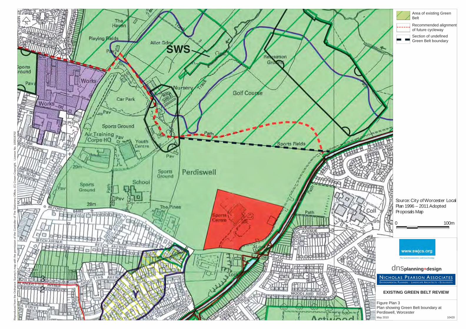
Rep
rodu
ced
from
the
Ord
nanc
e S
urve
y’s
map
with
the
perm
issi
on o
f the
Con
trolle
r of T
he S
tatio
nery
Offi
ce, (
C) C
row
n C
opyr
ight
. Li
cenc
e N
o. 1
0001
8702
N
EXISTING GREEN BELT REVIEW
Figure Plan 3Plan showing Green Belt boundary at Perdiswell, Worcester May 2010 10420
Recommended alignment of future cyclewaySection of undefi ned Green Belt boundary
Area of existing Green Belt
0 100m 200m 500m0 100m
Source: City of Worcester Local Plan 1996 – 2011 Adopted Proposals Map
dnsplanning+design
Green Belt Review SWJCS Team SWJCS Area
DNS / NPA Date: 29 July 2010
APPENDIX 1
GREEN BELT REVIEW METHODOLOGY
Methodology
1. The methodology for the Green Belt review was undertaken in three stages:
i. Assessment of the Green Belt Area
ii. Analysis of the Sub Areas / Review
iii. Conclusions
Approach to Methodology
2. When expanded the approach to the methodology can be depicted as follows:
Background to Green Belt (desk based)
History / Background
Policy / Guidance
Planning Considerations
Assessment of Green Belt (on site)
Site Visit / Field Survey
Boundaries
Analysis
GB Purpose / Criteria
Appraisal
Review
Evaluation of Initial Findings / Groupings
Analysis of findings and assessment against brief
Conclusions
Presentation to JAP
Conclusions on the Assessment, Analysis and Review
Assessment of the Green Belt Area
3. Desk Based Assessment – The initial desk based assessment reviewed the context to the
South Worcestershire Green Belt and provided a chronology of its evolution. This
provided a base position from which to conduct the site visits and subsequent analysis of
the sub areas.
Green Belt Review SWJCS Team SWJCS Area
DNS / NPA Date: 29 July 2010
4. Site Visits - The starting point for identifying the detailed study areas for the review was
undertaken through extensive sites visit across the whole of the Green Belt area. It was
decided that in order to make an assessment of the total area the Green Belt should be
considered in five distinct sub areas.
5. It was decided that no areas of Green Belt should be excluded from the review on the
basis that all the designated land should all be equally assessed.
6. A detailed review of all of the Green Belt boundaries was undertaken as part of the
review. The established boundaries play a significant role in defining the Green Belt
extent and particular attention was paid to assessing their strength and level of
robustness.
Analysis of the Sub Areas / Review
7. Previous Green Belt reviews for other authorities have adopted a range of different
criterion for assessment. Some of these have been based around qualitative and
quantitative judgements, with others being based upon numerical scoring systems that
are weighted to reflect the particular requirements of the study, this being undertaken
especially where such studies were required to identify locations for developments on
land that was, at the time of the related study, designated as Green Belt.
8. The Review of Green Belt within the SWJCS Study Area has been undertaken principally
to appraise whether the existing designated Green Belt is meeting the purposes of PPG2.
Therefore it was considered that the use of numerical scoring and weighting systems,
better served to those reviews where there was a specific need to identify land to be
removed from the Green Belt, would not be appropriate.
9. It was therefore considered that the appraisal of the SWJCS Green Belt should be
conducted using a qualitative judgement using a set assessment criteria. This was to
ensure that the review provided a balanced overall assessment of the whole Green Belt
and was most appropriate in deciding the extent to which it was fulfilling the purposes of
including land in the Green Belt. It was considered that a detailed site by site analysis of
each individual pocket or land parcel within the Green Belt would risk becoming side
tracked in the site specific details of the particular site and not have full regard to the
wider Green Belt context. It was further considered that if site specific development
proposals were being promoted through the LDF process then they could be addressed
on their respective site specific merits having regard to the wider findings of the Green
Belt review.
10. The criteria for analysis were predicated upon the five Green Belt purposes as stated in
PPG2. The analysis also had regard to relevant planning policy guidance and existing

Green Belt Review SWJCS Team SWJCS Area
DNS / NPA Date: 29 July 2010
Green Belt policy evolution. This provided a basis for the appraisal of the sub-areas
identified within the Green Belt in the initial assessment. The five purposes for including
land are:
1. to check the unrestricted sprawl of large built-up areas;
2. to prevent neighbouring towns from merging into one another;
3. to assist in safeguarding the countryside from encroachment;
4. to preserve the setting and special character of historic towns; and
5. to assist in urban regeneration, by encouraging the recycling of derelict and other
urban land.
11. The appraisal considers the extent to which the Green Belt sub-areas were fulfilling the
five purposes and had regard to the following criterion:
Purpose 1 – checking unrestricted sprawl: Considered the extent to which the Green
Belt prevented ribbon development and provided an established boundary to
settlements within or adjoining the designated area. Consideration was given to the
extent to which the prevention of urban development was contributing to the purpose
of the Green Belt.
Purpose 2 – preventing neighbouring towns from merging: Considered how the sub
areas achieve the purpose of separating settlements having regard to the distances
from the outer boundaries to settlements.
Purpose 3 – safeguarding the countryside from encroachment: The approach
adopted was to consider this purpose alongside purpose 1 and to examine the
boundaries between the urban area and the countryside. Consideration was given to
pressure for development from existing settlements into the countryside and also to
the potential for non-urban commercial development within the Green Belt that was
not associated with a particular settlement.
Purpose 4 – preserving historic towns: Considered the extent to which the Green
Belt contributes to preserving the setting of Droitwich Spa and Worcester including
conservation areas within them.
Purpose 5 – assist in urban regeneration: Considered the extent to which the land
within the Green Belt fulfilled this purpose by having regard to the opportunities
presented within the defined area. It was considered that not all areas of the
Green Belt were equal in this respect and whilst they might generically all contribute
Green Belt Review SWJCS Team SWJCS Area
DNS / NPA Date: 29 July 2010
towards focussing development to the urban areas there were nevertheless
regeneration site within the Green Belt to be considered.
12. Boundaries - The assessment considers whether the existing Green Belt boundary is
clearly defined using recognisable features and is robust. The boundaries of the south
Worcestershire Green Belt are well established and fulfil a critical role in defining its
extent. The analysis of the sub areas considered whether the existing boundaries were
satisfactory and if they were clearly defined.
13. The boundary review also considered the settlement and ADR boundaries in the study
area and examined whether there were any existing anomalies, including drafting
anomalies; and whether there were any areas that could be excluded from, or added into
the Green Belt on land immediately adjoining the boundary.
Conclusions
14. The Review makes independent recommendations about the future of the Green Belt to
the SWJCS team based on an evaluation of the findings and whether the land continues
to fulfil its purpose as Green Belt within the study area.
15. The evaluation of the Green Belt assessment was analysed by sub area against the
defined criteria and the brief. Matrices were not used as it was considered that qualitative
judgments can not be given a quantitative weighting or score for comparative purposes.
The final synthesis of this information has been presented in written form in the report.
References
Calderdale Council; Green Belt Review Methodology Consultation, November 2008
Calderdale Council; Green Belt Review Methodology Comments and Feedback, March 2009
Cheltenham Borough Council; Green Belt Review, AERC Ltd, March 2007
Coventry Green Belt Review; DLS Planning, December 2007
East Cambridgeshire District Council; Green Belt Review, September 2005
EMRA, Nottingham - Derby Green Belt Review, April 2006
Hereford & Worcester County Council Green Belt Local Plan, November 1982
Planning Policy Guidance 2: Green belts, 1995
Green Belt Review SWJCS Team SWJCS Area
DNS / NPA Date: 29 July 2010
Purbeck District Council; Green Belt Review, June 2006
Redditch Borough Council; A Study of Green Belt Land & ADRs, October 2008
Town and Country Planning in the UK; Cullingworth & Nadin, 14th Ed 2006
West Midlands Regional Assembly; Green Belt Annual Monitoring Report 2007, April 2008
West Midlands Regional Spatial Strategy Phase Two Revision – Report of the Panel:
Volume 1 – Report, September 2009
Worcester City Council, City of Worcester Local Plan 1996 – 2011, December 2007
Worcester City Council, Green Belt Local Plan Written Statement, April 1992
Worcestershire Structure Plan, September 1975
Worcestershire County Structure Plan 1996-2011, 2001
Wychavon District Council, Wychavon District Local Plan Inspectors Report, September 1994
Wychavon District Council, Proposed Modifications to the Wychavon District Local Plan
Deposit Version, November 1995
Wychavon District Council, Wychavon District Local Plan, January 1998
Wychavon District Council, Wychavon District Local Plan Review Inspectors Report,
October 2005
Wychavon District Council, Wychavon District Local Plan Review Proposed Modifications
Report, January 2006
Wychavon District Council, Wychavon District Local Plan, June 2006

Green Belt Review SWJCS Team SWJCS Area
DNS / NPA Date: 29 July 2010
APPENDIX 2
PPG2 – GREEN BELTS

Planning Policy Guidance 2: Green belts
Contents
Foreword.........................................................................................................................2
1. Introduction................................................................................................................3
2. Designation Of Green Belts .......................................................................................5
3. Control Over Development .......................................................................................8
4. Cancellation Of Advice ............................................................................................12
Annex A.........................................................................................................................13
Annex B.........................................................................................................................14
Annex C.........................................................................................................................15
Annex D.........................................................................................................................18
Annex E.........................................................................................................................20
Foreword "Planning Policy Guidance notes (PPGs) set out the Government's policies on different aspects of planning. Local planning authorities must take their content into account in preparing their development plans. The guidance may also be material to decisions on individual planning applications and appeals.
This PPG replaces the 1988 version of PPG2, and advice in Circulars. It:
• states the general intentions of Green Belt policy, including its contribution to sustainable development objectives;
• reaffirms the specific purposes of including land in Green Belts, with slight modifications;
• gives policy a more positive thrust by specifying for the first time objectives for the use of land in Green Belts;
• confirms that Green Belts must be protected as far as can be seen ahead, advises on defining boundaries and on safeguarding land for longer-term development needs; and
• maintains the presumption against inappropriate development within Green Belts and refines the categories of appropriate development, including making provision for the future of major existing developed sites and revising policy on the re-use of buildings."

1. Introduction
1.1 The Government attaches great importance to Green Belts, which have been an essential element of planning policy for some four decades. The purposes of Green Belt policy and the related development control policies set out in 1955 remain valid today with remarkably little alteration.
History
1.2 The first official proposal "to provide a reserve supply of public open spaces and of recreational areas and to establish a green belt or girdle of open space" was made by the Greater London Regional Planning Committee in 1935. New provisions for compensation in the 1947 Town and Country Planning Act allowed local authorities to incorporate green belt proposals in their first development plans. The codification of Green Belt policy and its extension to areas other than London came in 1955 with an historic circular inviting local planning authorities to consider the establishment of Green Belts.
Extent
1.3 The Green Belts approved through structure plans now cover approximately 1,556,000 hectares, about 12 per cent of England. There are 14 separate Green Belts, varying in size from 486,000 hectares around London to just 700 hectares at Burton-on-Trent. "The general extent and location of the designated areas are given in the table and map opposite."
Intentions of policy
1.4 The fundamental aim of Green Belt policy is to prevent urban sprawl by keeping land permanently open; the most important attribute of Green Belts is their openness. Green Belts can shape patterns of urban development at sub-regional and regional scale, and help to ensure that development occurs in locations allocated in development plans. They help to protect the countryside, be it in agricultural, forestry or other use. They can assist in moving towards more sustainable patterns of urban development (see paragraph 2.10).
Purposes of including land in Green Belts
1.5 There are five purposes of including land in Green Belts:
- to check the unrestricted sprawl of large built-up areas;
- to prevent neighbouring towns from merging into one another;
- to assist in safeguarding the countryside from encroachment;
- to preserve the setting and special character of historic towns; and
- to assist in urban regeneration, by encouraging the recycling of derelict and other urban land.
The use of land in Green Belts
1.6 Once Green Belts have been defined, the use of land in them has a positive role to play in fulfilling the following objectives:
- to provide opportunities for access to the open countryside for the urban population;

- to provide opportunities for outdoor sport and outdoor recreation near urban areas;
- to retain attractive landscapes, and enhance landscapes, near to where people live;
- to improve damaged and derelict land around towns;
- to secure nature conservation interest; and
- to retain land in agricultural, forestry and related uses.
1.7 The extent to which the use of land fulfils these objectives is however not itself a material factor in the inclusion of land within a Green Belt, or in its continued protection. For example, although Green Belts often contain areas of attractive landscape, the quality of the landscape is not relevant to the inclusion of land within a Green Belt or to its continued protection. The purposes of including land in Green Belts are of paramount importance to their continued protection, and should take precedence over the land use objectives.

2. Designation Of Green Belts 2.1 The essential characteristic of Green Belts is their permanence. Their protection must be maintained as far as can be seen ahead.
Regional guidance and development plans
2.2 Regional and strategic planning guidance set the framework for Green Belt policy and settlement policy, including the direction of long-term development. Regional guidance focuses on issues which are of regional importance or which need to be considered on a wider geographical basis than that of individual structure plans. Strategic guidance performs a similar role in metropolitan areas.
2.3 Green Belts are established through development plans. Structure plans provide the strategic policy context for planning at local level. The general extent of Green Belts has been fixed through the approval of structure plans.
2.4 Many detailed Green Belt boundaries have been set in local plans and in old development plans, but in some areas detailed boundaries have not yet been defined. Up-to-date approved boundaries are essential, to provide certainty as to where Green Belt policies do and do not apply and to enable the proper consideration of future development options. The mandatory requirement for district-wide local plans, introduced by the Planning and Compensation Act 1991, will ensure that the definition of detailed boundaries is completed.
2.5 In metropolitan areas, unitary development plans (UDPs) perform the functions of structure and local plans.
Defining boundaries
2.6 Once the general extent of a Green Belt has been approved it should be altered only in exceptional circumstances. If such an alteration is proposed the Secretary of State will wish to be satisfied that the authority has considered opportunities for development within the urban areas contained by and beyond the Green Belt. Similarly, detailed Green Belt boundaries defined in adopted local plans or earlier approved development plans should be altered only exceptionally. Detailed boundaries should not be altered or development allowed merely because the land has become derelict.
2.7 Where existing local plans are being revised and updated, existing Green Belt boundaries should not be changed unless alterations to the structure plan have been approved, or other exceptional circumstances exist, which necessitate such revision.
2.8 Where detailed Green Belt boundaries have not yet been defined, it is necessary to establish boundaries that will endure. They should be carefully drawn so as not to include land which it is unnecessary to keep permanently open. Otherwise there is a risk that encroachment on the Green Belt may have to be allowed in order to accommodate future development. If boundaries are drawn excessively tightly around existing built-up areas it may not be possible to maintain the degree of permanence that Green Belts should have. This would devalue the concept of the Green Belt and reduce the value of local plans in making proper provision for necessary development in the future.
2.9 Wherever practicable a Green Belt should be several miles wide, so as to ensure an appreciable open zone all round the built-up area concerned. Boundaries should be clearly defined, using readily recognisable features such as roads, streams, belts of trees or woodland edges where
possible. Well-defined long-term Green Belt boundaries help to ensure the future agricultural, recreational and amenity value of Green Belt land, whereas less secure boundaries would make it more difficult for farmers and other landowners to maintain and improve their land. Further advice on land management is in Annex A.
2.10 When drawing Green Belt boundaries in development plans local planning authorities should take account of the need to promote sustainable patterns of development. They should consider the consequences for sustainable development (for example in terms of the effects on car travel) of channelling development towards urban areas inside the inner Green Belt boundary, towards towns and villages inset within the Green Belt, or towards locations beyond the outer Green Belt boundary.
2.11 Guidance on the treatment of existing villages in Green Belts is given in the box below. The advice on affordable housing in paragraph 3.4 is also relevant.
Existing Villages
Development plans should treat existing villages in Green Belt areas in one of the following ways.
If it is proposed to allow no new building beyond the categories in the first three indents of paragraph 3.4, the village should be included within the Green Belt. The Green Belt notation should be carried across ("washed over") it.
If infilling only is proposed, the village should either be "washed over" and listed in the development plan or should be inset (that is, excluded from the Green Belt). The local plan should include policies to ensure that any infill does not have an adverse effect on the character of the village concerned. If the village is washed over, the local plan may need to define infill boundaries to avoid dispute over whether particular sites are covered by infill policies.
If limited development (more than infilling) or limited expansion is proposed, the village should be inset. Development control policies for such settlements should be included in the local plan.
Safeguarded land
2.12 When local planning authorities prepare new or revised structure and local plans, any proposals affecting Green Belts should be related to a time-scale which is longer than that normally adopted for other aspects of the plan. They should satisfy themselves that Green Belt boundaries will not need to be altered at the end of the plan period. In order to ensure protection of Green Belts within this longer timescale, this will in some cases mean safeguarding land between the urban area and the Green Belt which may be required to meet longer-term development needs. Regional/strategic guidance should provide a strategic framework for considering this issue. In preparing and reviewing their development plans authorities should address the possible need to provide safeguarded land. They should consider the broad location of anticipated development beyond the plan period, its effects on urban areas contained by the Green Belt and on areas beyond it, and its implications for sustainable development. In non-metropolitan areas these questions should in the first instance be addressed in the structure plan, which should where necessary indicate a general area where local plans should identify safeguarded land.

2.13 Annex B gives further advice on safeguarded land, which is sometimes known as "white land".
New Green Belts
2.14 Proposals for new Green Belts should be considered through the Regional/Strategic Guidance or Structure Plan process in the first instance. If a local planning authority proposes to establish a new Green Belt, it should demonstrate why normal planning and development control policies would not be adequate, and whether any major changes in circumstances have made the adoption of this exceptional measure necessary. It should also show what the consequences of the proposal would be for sustainable development.

3. Control Over Development
Presumption against inappropriate development
3.1 The general policies controlling development in the countryside apply with equal force in Green Belts but there is, in addition, a general presumption against inappropriate development within them. Such development should not be approved, except in very special circumstances. See paragraphs 3.4, 3.8, 3.11 and 3.12 below as to development which is inappropriate.
3.2 Inappropriate development is, by definition, harmful to the Green Belt. It is for the applicant to show why permission should be granted. Very special circumstances to justify inappropriate development will not exist unless the harm by reason of inappropriateness, and any other harm, is clearly outweighed by other considerations. In view of the presumption against inappropriate development, the Secretary of State will attach substantial weight to the harm to the Green Belt when considering any planning application or appeal concerning such development.
3.3 Green Belt policies in development plans should ensure that any planning applications for inappropriate development would not be in accord with the plan. These exceptional cases would thus be treated as departures from the development plan, to be referred to the Secretary of State under the Town and Country Planning (Development Plans and Consultation) Directions 1992 (see DOE Circular 19/92).
New buildings
3.4 The construction of new buildings inside a Green Belt is inappropriate unless it is for the following purposes:
- agriculture and forestry (unless permitted development rights have been withdrawn - see paragraph D2 of Annex D);
- essential facilities for outdoor sport and outdoor recreation, for cemeteries, and for other uses of land which preserve the openness of the Green Belt and which do not conflict with the purposes of including land in it (see paragraph 3.5 below);
- limited extension, alteration or replacement of existing dwellings (subject to paragraph 3.6 below);
- limited infilling in existing villages (under the circumstances described in the box following paragraph 2.11), and limited affordable housing for local community needs under development plan policies according with PPG3 (see Annex E, and the box following paragraph 2.11); or
- limited infilling or redevelopment of major existing developed sites identified in adopted local plans, which meets the criteria in paragraph C3 or C4 of Annex C1.
3.5 Essential facilities (see second indent of paragraph 3.4) should be genuinely required for uses of land which preserve the openness of the Green Belt and do not conflict with the purposes of including land in it. Possible examples of such facilities include small changing rooms or unobtrusive spectator accommodation for outdoor sport, or small stables for outdoor sport and outdoor recreation.
3.6 Provided that it does not result in disproportionate additions over and above the size of the original building, the extension or alteration of dwellings is not inappropriate in Green Belts. The 1 See also the transitional provision of paragraph C14 regarding redundant hospital sites and paragraph C17 regarding higher and further education establishments not identified in adopted local plans.

replacement of existing dwellings need not be inappropriate, providing the new dwelling is not materially larger than the dwelling it replaces. Development plans should make clear the approach local planning authorities will take, including the circumstances (if any) under which replacement dwellings are acceptable.
Re-use of buildings
3.7 With suitable safeguards, the re-use of buildings should not prejudice the openness of Green Belts, since the buildings are already there. It can help to secure the continuing stewardship of land, especially by assisting farmers in diversifying their enterprises, and may contribute to the objectives for the use of land in Green Belts. The alternative to re-use may be a building that is left vacant and prone to vandalism and dereliction.
3.8 The re-use of buildings inside a Green Belt is not inappropriate development providing:
(a) it does not have a materially greater impact than the present use on the openness of the Green Belt and the purposes of including land in it;
(b) strict control is exercised over the extension of re-used buildings, and over any associated uses of land surrounding the building which might conflict with the openness of the Green Belt and the purposes of including land in it (e.g. because they involve extensive external storage, or extensive hardstanding, car parking, boundary walling or fencing);
(c) the buildings are of permanent and substantial construction, and are capable of conversion without major or complete reconstruction; and
(d) the form, bulk and general design of the buildings are in keeping with their surroundings2. (Conversion proposals may be more acceptable if they respect local building styles and materials, though the use of equivalent natural materials that are not local should not be ruled out).
3.9 If a proposal for the re-use of a building in the Green Belt does not meet the criteria in paragraph 3.8, or there are other specific and convincing planning reasons for refusal (for example on environmental or traffic grounds), the local planning authority should not reject the proposal without considering whether, by imposing reasonable conditions, any objections could be overcome. It should not normally be necessary to consider whether the building is no longer needed for its present agricultural or other purposes3. Evidence that the building is not redundant in its present use is not by itself sufficient grounds for refusing permission for a proposed new use.
3.10 Local planning authorities should include in their development plans policies for the re-use of buildings in Green Belts, having regard to the advice above and in Annex D of this PPG.
Mining operations, and other development
3.11 Minerals can be worked only where they are found. Their extraction is a temporary activity. Mineral extraction need not be inappropriate development: it need not conflict with the purposes of including land in Green Belts, provided that high environmental standards are maintained and that the site is well restored. Mineral and local planning authorities should include appropriate policies in their development plans. Mineral planning authorities should ensure that planning conditions for
2 If a planning application is submitted for the re-use of a building which the local planning authority considers has a significant adverse effect on the landscape in terms of visual amenity, it may be appropriate in connection with any proposed structural changes to impose conditions to secure an improvement in the external appearance of the building. 3 In the case of a tenanted agricultural building, the value in planning terms of the existing use should however be taken into consideration.

mineral working sites within Green Belts achieve suitable environmental standards and restoration. Relevant advice is in MPG2 and MPG7. Paragraph 3.13 below is also relevant to mineral extraction.
3.12 The statutory definition of development includes engineering and other operations, and the making of any material change in the use of land. The carrying out of such operations and the making of material changes in the use of land are inappropriate development unless they maintain openness and do not conflict with the purposes of including land in the Green Belt. (Advice on material changes in the use of buildings is given in paragraph 3.8 above).
Land use objectives
3.13 When any large-scale development or redevelopment of land occurs in the Green Belt (including mineral extraction, the tipping of waste, and road and other infrastructure developments or improvements), it should, so far as possible contribute to the achievement of the objectives for the use of land in Green Belts (see paragraph 1.6). This approach applies to large-scale developments irrespective of whether they are appropriate development4, or inappropriate development which is justified by very special circumstances. Development plans should make clear the local planning authority's intended approach.
3.14 Planning obligations may be used to offset the loss of or impact on any amenity present on a site prior to development (see DoE Circular 16/91). In the case where amenity on a site adjacent to the Green Belt is lost as a result of development on that site, it may be reasonable for obligations to provide for offsetting benefits on land in the Green Belt, as long as there is a direct relationship between the two sites.
Visual amenity
3.15 The visual amenities of the Green Belt should not be injured by proposals for development within or conspicuous from the Green Belt which, although they would not prejudice the purposes of including land in Green Belts, might be visually detrimental by reason of their siting, materials or design.
Community Forests
3.16 Community Forests offer valuable opportunities for improving the environment around towns, by upgrading the landscape and providing for recreation and wildlife. An approved Community Forest plan may be a material consideration in preparing development plans and in deciding planning applications. Any development proposals within Community Forests in the Green Belt should be subject to the normal policies controlling development in Green Belts, and should respect the woodland setting.
This PPG was amended with effect from 27 March 2001 by Annex E of PPG13(Transport)which inserted new paragraphs 3.17-3.20 as below:
Park and ride
3.17 The countryside immediately around urban areas will often be the preferred location for park and ride schemes. In many instances, such land may be designated as Green Belt. The Governments commitment to maintaining the openness of the Green Belt means that when seeking to locate park
4 But see paragraph C4 of Annex C regarding the redevelopment of major developed sites.
and ride development, non-Green Belt alternatives should be investigated first. However, there may be cases where a Green Belt location is the most sustainable of the available options. Park and ride development is not inappropriate in Green Belts, provided that:
(a) a thorough and comprehensive assessment of potential sites has been carried out, including both non-Green Belt and, if appropriate, other Green Belt locations, having regard to sustainable development objectives, and the need to be flexible about size and layout;
(b) the assessment establishes that the proposed green belt site is the most sustainable option taking account of all relevant factors including travel impacts;
(c) the scheme will not seriously compromise the purposes of including land in Green Belts, as set out in paragraph 1.5;
(d) the proposal is contained within the local transport plan (or in Greater London the Local Implementation Plan) and based on a thorough assessment of travel impacts; and
(e) new or re-used buildings are included within the development proposal only for essential facilities associated with the operation of the park and ride scheme.
3.18 For larger-scale schemes local planning authorities must give particular attention to sub-paragraph (c) above. All the criteria in paragraph 3.17 should also be applied when considering proposals for expansion of existing sites. Approval of park and ride development in a particular location does not create any presumption in favour of future expansion of that site. All proposals must be considered on their merits.
3.19 In all cases, the layout, design and landscaping of the scheme must preserve, so far as possible, the openness and visual amenity of the Green Belt. Particular care will be needed on matters, such as floodlighting, which are essential to the safe operation of park and ride schemes but which may be visually intrusive unless carefully designed. Local authorities should make full use of planning conditions or obligations see paragraph 3.14 and Circulars 11/95 and 1/97.
3.20 Park and ride development which does not satisfy the criteria in paragraph 3.17 should be not be approved except in very special circumstances see paragraphs 3.2 and 3.3, and Circular 7/99.

4. Cancellation Of Advice 4.1 The following advice is hereby cancelled:
PPG2 (January 1988);
paragraphs 1-3 of Annex D to PPG12 (February 1992);
paragraph 34 of PPG17 (September 1991), except the first sentence;
DOE Circular 12/91;
DOE Circular 14/84, including the Annex reproducing MHLG Circulars 42/55 and 50/57.

Annex A
Land Management
A1 Local authorities can assist landowners in maintaining and improving their land by working together with them, with voluntary organisations including Groundwork Trusts, and with statutory bodies such as the Countryside Commission, the Forestry Commission, and (where significant areas of derelict or vacant land are involved) English Partnerships. The aim should be to enhance the countryside, and especially those areas of land within the Green Belt or adjacent to it, which are suffering from disuse or neglect.
A2 This is particularly important in areas that are close to existing urban development, or within conurbations, and which can be especially vulnerable to neglect or damage. They may come under intense pressure for development, and if so need to be protected and maintained. But in considering whether to include such areas of land within the Green Belt, where detailed boundaries have not yet been established, authorities should also consider carefully whether the land should be better reserved for future development and thus ease the pressure on other land that should have the long-term protection of the Green Belt. The overall aim should be to develop and maintain a positive approach to land management which both makes adequate provision for necessary development and ensures that the Green Belt serves its proper purpose.
Annex B
Safeguarded Land
B1 This guidance supplements that in paragraph 2.12, and should be read in conjunction with it.
Identifying safeguarded land
B2 Safeguarded land comprises areas and sites which may be required to serve development needs in the longer term, i.e. well beyond the plan period. It should be genuinely capable of development when needed.
B3 Safeguarded land should be located where future development would be an efficient use of land, well integrated with existing development, and well related to public transport and other existing and planned infrastructure, so promoting sustainable development.
B4 In identifying safeguarded land local planning authorities should take account of the advice on housing in PPG3 and on transport in PPG13. They should also have regard to environmental and landscape quality (so far as is consistent with paragraph 1.7 of this PPG); to the contribution which future redevelopment might make to remedying urban fringe problems, producing attractive, well-landscaped urban edges; and to the advice in PPG7 on protecting the best agricultural land.
Development control policies
B5 Development plans should state clearly the policies applying to safeguarded land over the period covered by the plan. They should make clear that the land is not allocated for development at the present time, and keep it free to fulfil its purpose of meeting possible longer-term development needs. No development which would prejudice later comprehensive development should be permitted (though temporary developments may assist in ensuring that the land is properly looked after). Valuable landscape and wildlife features and existing access for recreation should be protected.
B6 Development plan policies should provide that planning permission for the permanent development of safeguarded land should only be granted following a local plan or UDP review which proposes the development of particular areas of safeguarded land. Making safeguarded land available for permanent development in other circumstances would thus be a departure from the plan.
Annex C
Future Of Major Developed Sites In The Green Belt
C1 Green Belts contain some major developed sites such as factories, collieries, power stations, water and sewage treatment works, military establishments, civil airfields, hospitals, and research and education establishments. These substantial sites may be in continuing use or be redundant. They often pre-date the town and country planning system and the Green Belt designation.
C2 These sites remain subject to development control policies for Green Belts, and the Green Belt notation should be carried across them. If a major developed site is specifically identified for the purposes of this Annex in an adopted local plan or UDP, infilling or redevelopment which meets the criteria in paragraph C3 or C4 is not inappropriate development. In this context, infilling means the filling of small gaps between built development.
Infilling
C3 Limited infilling at major developed sites in continuing use may help to secure jobs and prosperity without further prejudicing the Green Belt. Where this is so, local planning authorities may in their development plans identify the site, defining the boundary of the present extent of development and setting out a policy for limited infilling for the continuing use within this boundary. Such infilling should:
(a) have no greater impact on the purposes of including land in the Green Belt (paragraph 1.5) than the existing development;
(b) not exceed the height of the existing buildings; and
(c) not lead to a major increase in the developed proportion of the site.
Redevelopment
C4 Whether they are redundant or in continuing use, the complete or partial redevelopment of major developed sites may offer the opportunity for environmental improvement without adding to their impact on the openness of the Green Belt and the purposes of including land within it. Where this is the case, local planning authorities may in their development plans identify the site, setting out a policy for its future redevelopment. They should consider preparing a site brief. Redevelopment should :
(a) have no greater impact than the existing development on the openness of the Green Belt and the purposes of including land in it, and where possible have less;
(b) contribute to the achievement of the objectives for the use of land in Green Belts (paragraph 1.6 - see also paragraph 3.13);
(c) not exceed the height of the existing buildings; and
(d) not occupy a larger area of the site than the existing buildings (unless this would achieve a reduction in height which would benefit visual amenity).
C5 The relevant area for the purposes of (d) is the aggregate ground floor area of the existing buildings (the "footprint"), excluding temporary buildings, open spaces with direct external access between wings of a building, and areas of hardstanding.
C6 The character and dispersal of proposed redevelopment will need to be considered as well as its footprint. For example many houses may together have a much smaller footprint than a few large buildings, but may be unacceptable because their dispersal over a large part of the site and enclosed gardens may have an adverse impact on the character of the Green Belt compared with the current development. The location of the new buildings should be decided having regard to the openness of the Green Belt and the purposes of including land in it, the objectives for the use of land in Green Belts, the main features of the landscape, and the need to integrate the new development with its surroundings. For instance it may be more appropriate to site new development closer to existing buildings.
C7 The site should be considered as a whole, whether or not all the buildings are to be redeveloped. The test of area in paragraph C5 relates to the redevelopment of the entire site; any proposals for partial redevelopment should be put forward in the context of comprehensive, long-term plans for the site as a whole.
C8 Proposals should be considered in the light of all material considerations, including for example visual amenity (see paragraph 3.15 of this PPG) and the traffic and travel implications of redevelopment (see PPG13).
C9 Where buildings are demolished rather than being left in a semi-derelict state pending decisions about their redevelopment, it will be necessary to keep suitable records for the purposes of paragraph C5. These should be agreed between the local planning authority and the landowner.
C10 In granting any planning permission local authorities may wish to consider whether to impose conditions to ensure that buildings which are not to be retained permanently are demolished as new buildings are erected, thus keeping the total developed area under control.
Architectural and historic interest
C11 Suitable re-use is to be preferred to redevelopment where the buildings are of architectural or historic interest. Any proposals for altering or demolishing listed buildings or which affect their settings should be considered in the light of the advice in PPG15, Planning and the Historic Environment.
C12 Local planning authorities should have regard to the desirability of preserving gardens and grounds of special historic interest. The English Heritage register of historic gardens lists sites of particular importance (see PPG15).
Public expenditure
C13 Redevelopment should not normally require additional expenditure by the public sector on the provision of infrastructure, nor should it overload local facilities such as schools and health care facilities. Local planning authorities should take account of any additional infrastructure requirements (eg roads) which may have significant adverse effects on the Green Belt. Adequate financial provision should where necessary be made for the future maintenance of landscaped areas (taking account of advice in DoE Circular 16/91, Planning Obligations).
Redundant hospitals
C14 The special position of redundant hospitals in Green Belts was recognised in DoE Circular 12/91 and earlier advice. That Circular is cancelled by this PPG; hospitals are covered by this Annex. As a transitional measure, pending the next local plan or UDP review, the redevelopment of redundant hospital sites which are not identified in development plans but meet the criteria in paragraph C4 above is not inappropriate development.

Higher and further education establishments
C15 Previous policy allowed "institutions standing in extensive grounds" to undertake new development, because such institutions pre-dated Green Belt policy. It was unclear how much new development was permitted. More recently this provision has been used to press for wholly new development on a scale that is inappropriate in the Green Belt. This revision of PPG2 makes it clear that development by institutions is subject to the same controls as other development in the Green Belt.
C16 It is however Government policy to encourage more people to undertake higher and further education (HFE). There has been a large increase in student numbers and further increases can be expected. The lack of a reasonable alternative site outside the Green Belt (whether within the urban area or elsewhere) for the proposed expansion of an HFE establishment located in or adjacent to the Green Belt should be taken into account in preparing or reviewing a development plan. Green Belt boundaries should be altered only in exceptional circumstances, after consideration of development opportunities within urban areas. Local planning authorities will wish to take an early opportunity to consult HFE establishments in or adjacent to the Green Belt about their development intentions. Plan preparation procedures provide opportunities for full public consultation on proposals to alter boundaries. Guidance on the timing of plan reviews is given in PPG12.
C17 Meanwhile, pending the next local plan or UDP review, the infilling or (partial or complete) redevelopment of HFE establishments on major sites in the Green Belt, which are not identified in development plans but otherwise meet the criteria in paragraph C3 or C4 of this Annex, is not inappropriate development. HFE establishments means: universities, colleges, schools and institutes of higher education; and establishments funded by the Further Education Funding Council for England, including colleges of further education, VI form colleges, and agricultural and horticultural colleges.

Annex D
Re-Use Of Buildings - Additional Advice
Agricultural buildings
D1 It is important to discourage abuse of permitted development rights. Local planning authorities should examine particularly carefully applications for re-use made within four years of the substantial completion of agricultural buildings erected under the General Development Order. This should alert them to the possibility that, when it was substantially completed, the building was in breach of planning control because there was no genuine agricultural justification.
D2 When granting permission for the use of agricultural buildings for non-agricultural purposes, local planning authorities should consider whether proliferation of farm buildings constructed under permitted development rights could have a seriously detrimental effect on the openness of the Green Belt. If so, they should consider whether it would be reasonable to attach a condition withdrawing these rights for new farm buildings in respect of that particular agricultural unit or holding. Such a condition should be used with great care, and must fairly and reasonably relate to the proposed development. While a restriction on additions to a particular group of farm buildings without specific permission might be reasonable, a restriction which sought to cover the whole of a large holding in connection with the re-use of a single building might well be unreasonable. Authorities should, where appropriate, include in their local plans a policy indicating the factors that they would take into account. If permitted development rights have been withdrawn, very special circumstances would need to be established for a new agricultural building to be permitted.
Residential conversions
D3 The following advice from PPG7, The Countryside and the Rural Economy (January 1992), is relevant to the re-use of buildings in Green Belts for residential purposes.
"In some villages, the pressure to convert existing buildings to dwellings is great, and applications for a change of use may, if granted, lead to adverse effects on the local rural economy. The need to accommodate local commerce and industry may well be a material consideration in deciding such applications." (Paragraph 2.13)
"Local planning authorities should examine applications for changes to residential use with particular care. The advice in paragraph D4 of PPG7, is often particularly relevant to such proposals. New housing in the open countryside is subject to strict control (paragraph 2.18 of PPG7); it may be appropriate to apply similar principles to proposals for the conversion of existing rural buildings to dwellings, especially where such buildings are unsuitable for conversion without extensive alteration, rebuilding and/or extension. Residential conversions can often have detrimental effects on the fabric and character of historic farm buildings. While new uses can frequently be the key to the preservation of historic buildings, it is important to ensure that the new use is sympathetic to the rural character. In addition, the creation of a residential curtilage around a newly converted building can sometimes have a harmful effect on the character of the countryside, especially in areas of high quality landscape, including National Parks and Areas of Outstanding Natural Beauty." (Paragraph D5)
"Residential conversions have a minimal impact on the rural economy. However conversions for holiday use can contribute more, and may reduce pressure to use other houses in the area for holiday use. Separate considerations apply to agricultural dwellings (see Annex E of PPG7)". (Paragraph D6).

Listed buildings
D4 If a building is listed, listed building consent may be needed for its conversion as well as planning permission (see PPG15).

Annex E
Further Guidance From Other PPGs And Circulars
Other PPGs and Circulars provide further guidance on Green Belt aspects of some specific types of development. Relevant passages are reproduced below.
Affordable Housing (from Annex A of PPG3, March 1992)
"11 This guidance does not alter the general presumption against inappropriate development in the Green Belts. Green Belt policy remains as set out in Planning Policy Guidance note 2.
"12 Most Green Belt areas are by their nature close to the main conurbations, and conditions are not typical of the generality of rural areas to which this policy is addressed. Special considerations may, however, arise in some of the more extensive areas of Green Belt away from the urban fringe, particularly in areas where there are many small settlements and it may not be practicable or appropriate to define Green Belt boundaries around each one.
"13 In some of these areas local planning policies already recognise that very limited development within existing settlements may be acceptable and consistent with the function of the Green Belt. It is for local planning authorities to judge whether low cost housing development for local community needs would fall within the scope of such policies.
"14 The release, exceptionally, for small-scale, low cost housing schemes of other sites within existing settlements, which would not normally be considered for development under such policies, would again be a matter for the judgement of the planning authority, having regard to all material considerations, including the objectives of Green Belt policy and the evidence of local need."
Motorway Service Areas (from Annex A of PPG13, March 1994)
"13 In Green Belts, there is a general presumption against inappropriate development. In line with PPG2, approval should not be given for an MSA within a Green Belt except in very special circumstances. One of the material considerations which could justify such an exception could be the lack of any signed MSAs. The greater the interval between the proposed site and any existing facility the more weight should be placed on the needs of motorway users. Developers should bear in mind the sensitive nature of Green Belt sites and avoid them where possible. Where no alternatives are readily available, developers will be expected to take great care to mitigate the likely impact of the development."
All-seater Football League Stadia (from PPG17, September 1991)
"50 Because of the size of the structures involved, major football stadia cannot be regarded as appropriate development within an approved Green Belt. As PPG2 makes clear, very special circumstances would be needed to justify setting aside the general presumption against inappropriate development in the Green Belts. It would be most unusual for a stadium proposal to meet those very special circumstances unless all other practicable options for location had been exhausted and other considerations had been fully addressed. A site for development as large as a major football stadium should normally be identified in a local plan. It could be considered alongside any proposal for the adjustment of Green Belt boundaries. Such boundaries should be altered only in exceptional circumstances, after consideration of development opportunities within urban areas. The procedures for making and reviewing local plans provide opportunities for full public consultation on proposals to alter boundaries."

Gypsy Sites (from paragraph 3 of DOE Circular 1/94)
"As a rule it will not be appropriate to make provision for gypsy sites in areas of open land where development is severely restricted, for example, Areas of Outstanding Natural Beauty, Sites of Special Scientific Interest, and other protected areas. Gypsy sites are not regarded as being among those uses of land which are normally appropriate in Green Belts. Green Belt land should not therefore be allocated for gypsy sites in development plans."
Published: 2 July 2001
Green Belt Review SWJCS Team SWJCS Area
DNS / NPA Date: 29 July 2010
APPENDIX 3
LAND TO THE SOUTH AND WEST OF WORCESTER
Potential for additional areas of Green Belt designated land to the west and east of
Worcester, and between Worcester and Great Malvern.
Introduction
The potential for, and possibility of, larger and/ or additional areas of Green Belt designated
land adjacent to or encircling Worcester have been variously proposed since the introduction
of Green Belt policy in 1955.
The reasons for this include:
1. Local pressure to protect land from development
2. As a means of „compensating‟ for either removal of Green Belt designation elsewhere
(actual or proposed)
3. As means of compensating for the loss of green field sites to development.
Constraints to assessment work
The Review of the existing Green Belt considered the possibility/ potential for undertaking
assessment and appraisal of large areas encircling Worcester in order to determine whether
Green Belt designation could and/ or should be made. However it was considered that such
assessment was not necessary or appropriate for the following reasons:
a. The Panel to the RSS specifically advises in paragraph 8.102 that the encirclement of
Worcester by Green Belt would be inappropriate as it would constrain the potential for
sustainable future urban development.
b. The methodology of the Review is to appraise existing Green Belt and is not considered
appropriate to apply the same approach for areas of undesignated Green Belt land.
c. The proposal of additional Green Belt designated land would require clarity on future
boundaries. Given the uncertainty over future urban extensions such appraisal work
would be subject to review when proposed or actual new urban boundaries had been
established.
Within the emerging South Worcestershire Joint Core Strategy, as part of planned growth,
there are preferred land areas identified for the creation of one or more sustainable urban

Green Belt Review SWJCS Team SWJCS Area
DNS / NPA Date: 29 July 2010
extensions to Worcester. These are located, in countryside, to the south and west, adjacent
to and beyond the city limits and within Malvern Hills and Wychavon administrative areas.
In order for a study to assess whether other areas beyond the existing urban boundary of
Worcester (eg. to the east, south and west), or other settlements, meet the purposes of Green
Belt, in accordance with PPG2, and if so whether such land should be considered for potential
designation as Green Belt it will therefore be necessary either to:
c. Assess the area beyond the existing urban edge as if no such urban extension is
proposed, or;
d. Define a clear urban boundary, or boundaries, for such an extension beyond which the
land can then be tested against the purposes of PPG2.
This study will not take into account these potential major areas of planned growth into the
countryside, which are currently indicative only, because there is no certainty of this change,
and therefore no long term and enduring urban boundary from which to assess any Green
Belt definition.

Green Belt Review SWJCS Team SWJCS Area
DNS / NPA Date: 29 July 2010
APPENDIX 4
DEVELOPMENT PLAN POLICIES
Worcestershire Structure Plan – Saved Green Belt Polices
Policy D.12 - Housing in the Green Belt
Housing in the Green Belt will only be allowed in those circumstances detailed in national
planning guidance, currently PPG2. Where housing proposals are such that in the terms of
PPG2 they constitute inappropriate development this will only be allowed where very special
circumstances can be demonstrated which outweigh their inappropriateness. Housing
permitted under this policy will be for local needs only in accordance with the development
strategy of the Structure Plan. Proposals for housing development on major developed sites
in the Green Belt are acceptable where they accord with this policy and PPG2, Annex C.
Policy D.38 - General Extent and Purposes of the Green Belt
A Green Belt will be maintained in the north-east of Worcestershire, with the purposes being
to:
(i) check the unrestricted sprawl of the West Midlands conurbation;
(ii) prevent neighbouring towns and villages from merging into one another;
(iii) assist in safeguarding the countryside from encroachment;
(iv) preserve the setting and special character of historic towns; and
(v) assist in urban regeneration by encouraging the recycling of derelict and other urban land.
The general extent of the Green Belt (shown on the Key Diagram) will cover the area to the
south-west of the West Midlands Conurbation between the County boundary with
Warwickshire to the east and the River Severn to the west, extended to the south of Redditch
and including land between Droitwich Spa and Worcester.
Policy D.39 - Control of Development in the Green Belt
There will be a presumption against allowing inappropriate development in the Green Belt as
described in national planning guidance currently PPG2. Where proposals constitute
inappropriate development in the terms of this guidance they will only be allowed where very
special circumstances exist which outweigh the harm to the Green Belt. PPG2 gives details
of exceptions to the general prevention of inappropriate development in the Green Belt. It will
be for the applicant to show why permission should be granted.
Development permitted in the Green Belt must also satisfy other relevant policies in the
Development Plan.

Green Belt Review SWJCS Team SWJCS Area
DNS / NPA Date: 29 July 2010
Policy D.40 - Green Belt Boundary Definition
Where Green Belt boundaries have still to be defined in Local Plans that definition will be
completed. In defining boundaries District Councils should have regard to the purposes of the
Green Belt set out in Policy D.38 and the need to safeguard land for longer term development
needs.
Worcester City Local Plan – Saved Green Belt Policies
The City Council will apply the following policies in respect of the Green Belt:
Policy NE12 - Green Belt Area
Green Belt policies NE13 - NE18 will be applied within the area shown as Green Belt on the
proposals map.
Advisory Note
Policies NE13 – 18 of the Worcester City Local Plan were not saved as they reiterated policy
advice in PPG2. Policy NE12 was saved as it defined the area of Green Belt within the
Local Plan area.
Wychavon Local Plan – Saved Green Belt Polices
Policy SR7 - Development in the Green Belt
Within the Green Belt, proposals will only be permitted for development where they:
a) would not detract from the open character of the Green Belt; or
b) would not conflict with the purposes of including land within it; and
c) (in both instances) are for one or more of the following purposes:
i) land uses for the purposes of agriculture, forestry, outdoor sports and recreation,
horse riding, cemeteries and other uses suitable to the rural area and which preserve
the openness of land;
ii) new buildings that meet a proven agricultural need or that are essential for uses
outlined under i) above;
iii) small-scale social housing schemes to meet proven local needs that accord with
Policy COM3 (Rural Exceptions Policy);
iv) limited infilling within defined development boundaries;
v) limited extension or replacement of existing buildings in accordance with
Policy SUR1, Policy SUR6 and Policy RES9 (Design, Extensions, and Replacement
Buildings);

Green Belt Review SWJCS Team SWJCS Area
DNS / NPA Date: 29 July 2010
vi) re-use of buildings in accordance with Policy RES7 and Policy RES8 (Conversion of
Existing Buildings); and
vii) the limited infilling of the identified employment sites in accordance with the
provisions of PPG2 Annexe C.
Policy SR8 - Major Developed Site in the Green Belt – Hartlebury Trading Estate
The protection of the Green Belt is an overriding planning consideration and there is a
presumption against inappropriate development within it. The Policy outlines the types of
development considered by national planning guidance (PPG2) to be appropriate within
Green Belts. Appropriate land uses are those which for the most part would retain the
openness of the Green Belt. Development that is necessary to the functioning of such land
uses is also an appropriate type of development in the Green Belt.
However, it is still important that the scale, location or design of buildings or structures does
not impair the open character of the Green Belt. The Major Developed Site (MDS) in the
Green Belt, identified on the Proposals Map at Hartlebury Trading Estate is regarded as being
suitable for redevelopment and environmental improvement under the provisions of PPG2
Annexe C. Proposals involving the redevelopment of this site should:
a) have no greater impact than the existing development on the openness of the Green Belt
and the purposes of including land within it, and where possible have less;
b) contribute to the achievement of the objectives for use of land in Green Belts, set out in
Policy SR7(Development in Green Belt) and have regard for the provisions of
Policy ECON1 (Employment Land);
c) not exceed the height of existing buildings; and
d) not occupy an area larger than the footprint of existing buildings, unless this would
achieve a reduction in height, which would benefit visual amenity.
Policy SR9 - Areas of Development Restraint
Areas of Development Restraint (ADR) are shown on the Proposals Map. Land identified as
an ADR will be safeguarded and will not be released unless and until it is required for
development in a future review of the Local Plan.

Green Belt Review SWJCS Team SWJCS Area
DNS / NPA Date: 29 July 2010
APPENDIX 5
LETTER TO PLANNING AUTHORITIES FROM SECRETARY OF STATE FOR COMMUNITIES AND LOCAL
GOVERNMENT, DATED 6 JULY 2010

Department for Communities and Local Government Eland House Bressenden Place London SW1E 5DU
The Chief Planning Officer Local Planning Authorities in England
6 July 2010
Chief Planning Officer Letter: REVOCATION OF REGIONAL STRATEGIES Today the Secretary of State announced the revocation of Regional Strategies with immediate effect. I have attached some ‘questions and answer’ advice on immediate issues that may arise from this announcement. It will be important for local planning authorities to carry on delivering local development frameworks and making decisions on applications and the attached document focuses on how to continue taking these forward. Please address any queries to Eamon Mythen at CLG in the first instance ([email protected]).
STEVE QUARTERMAIN Chief Planner

Guidance for Local Planning Authorities following the revocation of Regional Strategies The Secretary of State for Communities and Local Government confirmed today that Regional Strategies will be revoked (see the attached copy of the Parliamentary Written Statement). In the longer term the legal basis for Regional Strategies will be abolished through the “Localism Bill” that we are introducing in the current Parliamentary session. New ways for local authorities to address strategic planning and infrastructure issues based on cooperation will be introduced. This guidance provides some clarification on the impact of the revocation; how local planning authorities can continue to bring forward their Local Development Frameworks (LDFs); and make planning decisions in the transitional period. 1. Under what powers are Regional Strategies being revoked? Regional Strategies have been revoked under s79(6) of the Local Democracy Economic Development and Construction Act 2009 and no longer form part of the development plan for the purposes of s38(6) of the Planning and Compulsory Purchase Act 2004. This guidance covers the period between revocation of Regional Strategies and legislation to abolish them altogether. 2. Do Planning Policy Statements (PPSs) remain in force? Yes. The Policy Statement on Regional Strategies (February 2010) is cancelled, and references to Regional Strategies in other Policy Statements are no longer valid. But all other PPSs will continue to apply until they are replaced by the National Planning Framework. 3. Will this affect the London Plan? The London Plan will continue to provide the planning framework for London boroughs. As part of a wider process of decentralisation in London, we are reviewing how powers and discretion can be shifted downwards from central government to the Mayor and Assembly, to London Boroughs and to local neighbourhoods. This will include reviewing the scope for devolving power from the Greater London Authority down to the Boroughs and below. The following sections provide advice on some of the issues likely to arise following revocation of Regional Strategies, until the “Localism Bill” and the new National Planning Framework are in place. This guidance should be regarded as a material consideration by local planning authorities and the Planning Inspectorate in their decisions. 4. How will this affect planning applications? In determining planning applications local planning authorities must continue to have regard to the development plan. This will now consist only of:
• Adopted DPDs; • Saved policies; and

• Any old style plans that have not lapsed. Local planning authorities should also have regard to other material considerations, including national policy. Evidence that informed the preparation of the revoked Regional Strategies may also be a material consideration, depending on the facts of the case. Where local planning authorities have not yet issued decisions on planning applications in the pipeline, they may wish to review those decisions in light of the new freedoms following the revocation of Regional Strategies. The revocation of the Regional Strategy may also be a material consideration. 5. Should we continue preparing LDF documents? Yes – the revocation of Regional Strategies is not a signal for local authorities to stop making plans for their area. Local planning authorities should continue to develop LDF core strategies and other DPDs, reflecting local people’s aspirations and decisions on important issues such as climate change, housing and economic development. These local plans will guide development in their areas and provide certainty for investors and communities. Local authorities may wish to review their plans following the revocation of Regional Strategies. We recommend reviews should be undertaken as quickly as possible. 6. How does this affect adopted local plans / LDFs? Adopted DPDs and saved policies will continue to provide the statutory planning framework. Local authorities may decide to review these now that Regional Strategies have been revoked. There is no need to review the whole LDF, only those issues or policies which local authorities wish to revisit. When undertaking consultation and sustainability appraisal on their draft policies, authorities should take an approach that considers the stage reached, the extent of work already undertaken and the scope of the policy changes they are making. 7. What if my LDF document is still being prepared? Where local planning authorities are currently bringing forward development plan documents they should continue to do so. Authorities may decide to review and/or revise their emerging policies in the light of the revocation of Regional Strategies. Where authorities decide to do this they will need to ensure they meet the requirements for soundness under the current legislation. When undertaking consultation and sustainability appraisal on their draft policies, authorities should take an approach that considers the stage reached, the extent of work already undertaken and the scope of the policy changes they are making.

8. Will Examinations in Public continue for DPDs? Yes – where local planning authorities are bringing forward new development plan documents or reviewing adopted plans they should present evidence to support their plans. The examination process will continue to assess the soundness of plans, and Inspectors will test evidence put forward by local authorities and others who make representations. 9. Will data and research currently held by Regional Local Authority Leaders’ Boards still be available? Yes. The regional planning function of Regional LA Leaders’ Boards – the previous Regional Assemblies – is being wound up and their central government funding will end after September this year. The planning data and research they currently hold will still be available to local authorities for the preparation of their local plans whilst they put their own alternative arrangements in place for the collection and analysis of evidence. Notwithstanding, the new Government regards the Regional Leaders’ Boards as an unnecessary tier of bureaucracy. Clarification on policy issues There are a number of areas where Regional Strategies supplemented the national policy framework. Further clarification on these areas is set out below. 10. Who will determine housing numbers in the absence of Regional Strategy targets? Local planning authorities will be responsible for establishing the right level of local housing provision in their area, and identifying a long term supply of housing land without the burden of regional housing targets. Some authorities may decide to retain their existing housing targets that were set out in the revoked Regional Strategies. Others may decide to review their housing targets. We would expect that those authorities should quickly signal their intention to undertake an early review so that communities and land owners know where they stand. 11. Will we still need to justify the housing numbers in our plans? Yes – it is important for the planning process to be transparent, and for people to be able to understand why decisions have been taken. Local authorities should continue to collect and use reliable information to justify their housing supply policies and defend them during the LDF examination process. They should do this in line with current policy in PPS3. 12. Can I replace Regional Strategy targets with “option 1 numbers”? Yes, if that is the right thing to do for your area. Authorities may base revised housing targets on the level of provision submitted to the original Regional Spatial Strategy examination (Option 1 targets), supplemented by more recent information as appropriate. These figures are based on assessments undertaken by local authorities. However, any target selected may be tested during the examination process especially if challenged and authorities will need to be ready to defend them.
13. Do we still have to provide a 5 year land supply? Yes. Although the overall ambition for housing growth may change, authorities should continue to identify enough viable land in their DPDs to meet that growth. Strategic Housing Market Assessments and Strategic Housing Land Availability Assessments can help with this. Local planning authorities should continue to use their plans to identify sufficient sites and broad areas for development to deliver their housing ambitions for at least 15 years from the date the plan is adopted. Authorities should also have a five year land supply of deliverable sites. This too will need to reflect any changes to the overall local housing ambition. 14. How do we determine the level of provision for travellers’ sites? Local councils are best placed to assess the needs of travellers. The abolition of Regional Strategies means that local authorities will be responsible for determining the right level of site provision, reflecting local need and historic demand, and for bringing forward land in DPDs. They should continue to do this in line with current policy. Gypsy and Traveller Accommodation Assessments (GTAAs) have been undertaken by all local authorities and if local authorities decide to review the levels of provision these assessments will form a good starting point. However, local authorities are not bound by them. We will review relevant regulations and guidance on this matter in due course. 15. How do we establish the need for minerals and aggregates supply without Regional Strategy targets? Minerals planning authorities will have responsibility for continuing to plan for a steady and adequate supply of aggregate minerals to support economic growth. They should do this within the longstanding arrangements for minerals planning. Technical advice provided by the Aggregate Working Parties, including their current work in sub-apportioning the CLG guidelines for 2005-2020 to planning authority level will assist with this. Planning authorities in the South East should work from the apportionment set out in the "Proposed Changes" to the revision of Policy M3, published on 19 March 2010. Planning authorities can choose to use alternative figures for their planning purposes if they have new or different information and a robust evidence base. We will work with the minerals industry and local government to agree how minerals planning arrangements should operate in the longer term. 16. How do we establish the need for waste management without Regional Strategy targets? Planning Authorities should continue to press ahead with their waste plans, and provide enough land for waste management facilities to support the sustainable management of waste (including the move away from disposal of waste by landfill). Data and information prepared by partners will continue to assist in this process. For the transitional period this will continue to be the data and information which has been collated by the local authority and industry and other public bodies who

currently form the Regional Waste Technical Advisory Bodies. We intend for this function to be transferred to local authorities in due course. 17. Does the abolition of the hierarchy of strategic centres mean the end of policies on town centres? No. Local authorities must continue to have regard to PPS 4: Planning for Sustainable Economic Growth in preparing LDFs and, where relevant, take it into account in determining planning applications for retail, leisure and other main town centre uses. In assessing any planning applications proposing unplanned growth in out of town shopping centres, particularly those over 50,000 sqm gross retail floor area, local authorities should take account of the potential impacts of the development on centres in the catchment area of the proposal. 18. What about regional policies on the natural environment? Local authorities should continue to work together, and with communities, on conservation, restoration and enhancement of the natural environment – including biodiversity, geo-diversity and landscape interests. Authorities should continue to draw on available information, including data from partners, to address cross boundary issues such as the provision of green infrastructure and wildlife corridors. 19. What about regional policies on Flooding and Coastal Change? Local authorities should continue to work together across administrative boundaries to plan development that addresses flooding and coastal change. For flooding matters local authorities already have a duty to co-operate under the Floods and Water Management Act. The Environment Agency will continue to work with local authorities individually and/or jointly to provide technical support on these matters. The Coalition agreement is clear that we should prevent unnecessary building in areas of high flood risk. 20. What about regional policies on Renewable and Low Carbon Energy? Through their local plans, authorities should contribute to the move to a low carbon economy, cut greenhouse gas emissions, help secure more renewable and low carbon energy to meet national targets, and to adapt to the impacts arising from climate change. In doing so, planning authorities may find it useful to draw on data that was collected by the Regional Local Authority Leaders’ Boards (which will be made available) and more recent work, including assessments of the potential for renewable and low carbon energy. 21. What about regional policies on Transport? Local authorities should continue to ensure their land use and local transport plans are mutually consistent, and deliver the most effective and sustainable development for their area. Local authorities should work with each other and with businesses and communities to consider strategic transport priorities and cross boundary issues.

22. Does the end of Regional Strategies mean changes to Green Belt? No. The Government is committed to the protection of the Green Belt and the revocation of Regional Strategies will prevent top-down pressure to reduce the Green Belt protection. Local planning authorities should continue to apply policies in PPG2. As part of their preparation or revision of DPDs, planning authorities should consider the desirability of new Green Belt or adjustment of an existing Green Belt boundary, working with other local planning authorities as appropriate.

Parliamentary Statement Revoking Regional Strategies Today I am making the first step to deliver our commitment in the coalition agreement to “rapidly abolish Regional Spatial Strategies and return decision-making powers on housing and planning to local councils”, by revoking Regional Strategies. Regional Strategies added unnecessary bureaucracy to the planning system. They were a failure. They were expensive and time-consuming. They alienated people, pitting them against development instead of encouraging people to build in their local area. The revocation of Regional Strategies will make local spatial plans, drawn up in conformity with national policy, the basis for local planning decisions. The new planning system will be clear, efficient and will put greater power in the hands of local people, rather than regional bodies. Imposed central targets will be replaced with powerful incentives so that people see the benefits of building. The coalition agreement makes a clear commitment to providing local authorities with real incentives to build new homes. I can confirm that this will ensure that those local authorities which take action now to consent and support the construction of new homes will receive direct and substantial benefit from their actions. Because we are committed to housing growth, introducing these incentives will be a priority and we aim to do so early in the spending review period. We will consult on the detail of this later this year. These incentives will encourage local authorities and communities to increase their aspirations for housing and economic growth, and to deliver sustainable development in a way that allows them to control the way in which their villages, towns and cities change. Our revisions to the planning system will also support renewable energy and a low carbon economy. The abolition of Regional Strategies will provide a clear signal of the importance attached to the development and application of local spatial plans, in the form of Local Development Framework Core Strategies and other Development Plan Documents. Future reform in this area will make it easier for local councils, working with their communities, to agree and amend local plans in a way that maximises the involvement of neighbourhoods. The abolition of Regional Strategies will require legislation in the “Localism Bill” which we are introducing this session. However, given the clear coalition commitment, it is important to avoid a period of uncertainty over planning policy, until the legislation is enacted. So I am revoking Regional Strategies today in order to give clarity to builders, developers and planners. Regional Strategies are being revoked under s79(6) of the Local Democracy Economic Development and Construction Act 2009 and will thus no longer form part of the development plan for the purposes of s38(6) of the Planning and Compulsory Purchase Act 2004. Revoking, and then abolishing, Regional Strategies will mean that the planning system is simpler, more efficient and easier for people to understand. It will be firmly

rooted in the local community. And it will encourage the investment, economic growth and housing that Britain needs. We will be providing advice for local planning authorities today and a copy has been placed in the house library.

f7l HEAD oFFrcE:
f__l nvERroN oFFrcE:
30 BROCK STREET
I ST PAUL STREET
BATH
TIVERTON
BAI 2LN
EXI6 sHT
TEL:
TEL:
0 | 22s 445548
0 | 884 243037
FAX: 01225 312387
FAX: 01884 243038
Document Title: SWICS Green Belt ReviewJotFzo(J
FzIJJEf()
oo
Project No: | 0420
This documenc Original Revision
Signature
RevLetter: E
Name Position Date
Prepared by: Simon Kale Associate Director 29.7.20t0
Checked by:
Approved by: Nicholas Pearson 29.7.20t0
REVISION RECORD
This report hos been prepored in good foith, with oll reosonoble skill, care and diligence, bosed oninformotion provided or ovoiloble ot the time of its preporotion qnd within the scope of work ogneement with the client.
We discloim ony responsibitity to the client ond otllens in respect of any matten outside the scope of the obove.The report is provided for the sole use of the nomed client ond is confidentiol to them ond their professionol odvisors.
No rcsponsibitl,tV is occqted to others.
cBA
29.7.2010t6.7.20 r029.6.20t0
SKSKSK
NPNPNP
Revisions associated with minor commentsRevisions associated with RSS revocationMinor comments included
KevLetter
DatePrepared
Preparedby
Checker/Approver
Description of changes