surveying - european gnss agency · pdf filegnss market report | issue 5, 2017 gnss...
TRANSCRIPT
Surveying
Excerpt from the GNSS MARKET REPORT, ISSUE 5 (2017 )
ISSUE 5
E D I T O R ’ S S P E C I A LD R O N E S
GNSS Market Report | Issue 5, 2017
GNSS applicationsApplications in Land Surveying:n Cadastral surveying aims at establishing property boundaries. Fiscal policies such as
land taxation rely widely on cadastral surveying.n Construction surveying covers the different construction stages of a building or civil en-
gineering work, whereas machine control applications automate construction activities:n Machine control applications use GNSS positioning, for example to automatically
control the blades and buckets of construction equipment based on information pro-vided by 3D digital design.
n Person-based applications involve topographic surveys for constructions sites, check-ing levels, performing “as-built” checks or stake out reference points and markers.
n Mapping: GNSS is used to define specific location points of interest for cartographic, environmental and urban planning purposes.
n Mine Surveying: mine surveying involves measurements and calculations at each stage of mine exploitation, including safety check.
n Infrastructure Monitoring: GNSS is used to monitor critical infrastructure and the natu-ral environment to prevent major disaster and promptly intervene in case of emergency.
Applications in Marine Surveying:n Marine surveying: encompasses a wide range of activities (seabed exploration, tide and
current estimation, offshore surveying, etc.), and their outcomes are important for mari-time navigation.
Augmentation techniques used in surveyingIn order to achieve high accuracy, GNSS surveying equipment uses GNSS augmentation techniques that can range from satellite based augmentation systems (SBAS) to DGNSS, PPP and RTK.
Real Time Kinematics (RTK) is an augmentation technique based on differential GNSS that provides real-time cm-level positioning accuracy in the vicinity of a base station. Network RTK implementation relies on networks of stations covering a geographical area of interest which transmit GNSS positioning corrections. RTK data are usually accessible via a subscrip-tion fee.
An overview of RTK market and infrastructures is provided in this section.
Surveying
74
What you can read in this chaptern Key trends: Technology sophistication and services development: how the democratisa-
tion of mapping and crowdsourcing data are boosting the industry evolution.n User perspective: User requirements segmentation and need of interoperability bring
new challenges and opportunities for the GNSS industry.n Industry: List of main players by value chain segments.n Recent developments: Construction, mapping and cadastral industries stimulated
growth in shipments of GNSS surveying equipment.n Future market evolution: Construction activities in Asia-Pacific and North America will
drive GNSS growth. n European GNSS: EGNSS set to be key differentiators in mapping and surveying domains.n Reference charts: Annual evolution of GNSS devices’ installed base and revenues by appli-
cation and region.
Infrastructure Monitoring quantified in this edition of the GNSS Market Report
© G
etty
imag
es
GNSS Market Report | Issue 5, 2017
SURVEYING 75KEY TRENDS
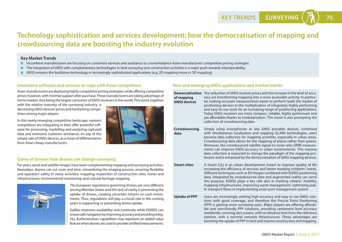
Key Market Trendsn Incumbent manufacturers are focusing on customers services and assistance to counterbalance Asian manufactures’ competitive pricing strategies. n The integration of GNSS with complementary technologies in land surveying and construction activities is a major push towards interoperability.n GNSS remains the backbone technology in increasingly sophisticated applications (e.g. 2D mapping move to 3D mapping).
Technology sophistication and services development: how the democratisation of mapping and crowdsourcing data are boosting the industry evolution
Game of drones: how drones can change surveyingFor years, aerial and satellite images have been complementing mapping and surveying activities. Nowadays, drones can cut costs and time, streamlining the imaging process, ensuring flexibility and operators’ safety in many activities: mapping; inspection of construction sites, mines and infrastructures; environmental monitoring; and cultural heritage mapping.
The European regulations governing drones are very different among Member States and this lack of clarity is preventing the uptake of drones, creating uncertain returns on such invest-ments. Thus, regulations will play a crucial role in the coming years in supporting or preventing drone uptake.
Galileo improves availability and continuity while EGNOS can ensure safe navigation by improving accuracy and providing integ-rity. Authentication capabilities may represent an added-value feature when drones are used to provide certified measurements.
Democratisation of mapping GNSS devices
The reduction of GNSS receiver prices and the increase in the level of accu-racy are transforming mapping into a more accessible activity. In particu-lar, making accurate measurements easier to perform leads the market of positioning devices to the multiplication of integrated, highly performing and easy-to-use tools for an increasing range of positioning applications. Today GNSS receivers are more compact, reliable, highly performant and yet affordable thanks to modularisation. This trend is also prompting the collection of crowdsourcing data.
Crowdsourcing data
Simply using smartphones or any GNSS portable devices, combined with simultaneous localisation and mapping (SLAM) technologies, users become data collectors for mapping activities, especially in urban areas. Crowdsourcing data allows for the mapping of places rather than spaces. Moreover, the crowdsourced satellite signal-to-noise ratio (SNR) measure-ments can improve GNSS accuracy in urban environments. This massive data collection is expected to change the paradigm of the mapping pro-fession and is enhanced by the democratisation of GNSS mapping devices.
Smart cities A Smart City is an urban development meant to improve quality of life increasing the efficiency of services and better meeting residents’ needs. Different techniques such as EO images combined with EGNSS positioning data, integrated by crowdsourced data and augmented reality can serve this purpose. EGNSS plays a key role also in tracking citizens’ mobility, mapping infrastructures, improving waste management, optimising pub-lic transport flows or implementing smart port management system.
Uptake of PPP Users are increasingly seeking high-accuracy and easy to use GNSS solu-tions with good coverage, and therefore the Precise Point Positioning (PPP) is gaining more surveying users. Major players are offering afforda-ble and user-friendly PPP solutions, providing centimetre level accuracy worldwide, covering also oceans, with no distance limit from the reference stations, with a minimal network infrastructure. These advantages are boosting the uptake of PPP in land and marine construction and mapping.
New and emerging GNSS applications and market trendsInnovative software and services to cope with Asian competitorsAsian manufacturers are deploying highly competitive pricing strategies; while offering competitive prices; however, with minimal support after purchase. These manufacturers are taking advantage of home market, Asia being the largest consumer of GNSS receivers in the world. This trend, together with the relative maturity of the surveying industry, is decreasing GNSS devices’ prices and harshening compe-tition among major players.
In this newly emerging competitive landscape, western competitors are integrating in their offer powerful soft-ware for processing, modelling and analysing captured data and extensive customer assistance, on top of the simple sale of GNSS devices, as a mean of differentiation from Asian cheap manufacturers. ©
Get
ty im
ages
© G
etty
imag
es
GNSS Market Report | Issue 5, 2017
76 SURVEYING USER PERSPECTIVE
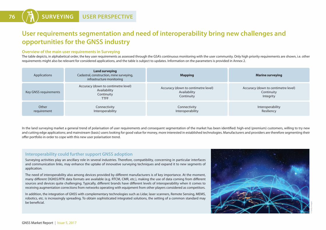
Applications
Key GNSS requirements
Other requirement
Land surveying Cadastral, construction, mine surveying,
infrastructure monitoring
Accuracy (down to centimetre level)AvailabilityContinuity
TTFF
Connectivity Interoperability
Mapping Marine surveying
Accuracy (down to centimetre level)Availability Continuity
Accuracy (down to centimetre level)ContinuityIntegrity
Connectivity Interoperability
InteroperabilityResiliency
Overview of the main user requirements in SurveyingThe table depicts, in alphabetical order, the key user requirements as assessed through the GSA’s continuous monitoring with the user community. Only high priority requirements are shown, i.e. other requirements might also be relevant for considered applications, and the table is subject to updates. Information on the parameters is provided in Annex 2.
In the land surveying market a general trend of polarisation of user requirements and consequent segmentation of the market has been identified: high-end (premium) customers, willing to try new and cutting edge applications; and mainstream (basic) users looking for good value for money, more interested in established technologies. Manufacturers and providers are therefore segmenting their offer portfolio in order to cope with this new user polarisation trend.
User requirements segmentation and need of interoperability bring new challenges andopportunities for the GNSS industry
Interoperability could further support GNSS adoptionSurveying activities play an ancillary role in several industries. Therefore, compatibility, concerning in particular interfaces and communication links, may enhance the uptake of innovative surveying techniques and expand it to new segments of application.
The need of interoperability also among devices provided by different manufacturers is of key importance. At the moment, many different DGNSS/RTK data formats are available (e.g. RTCM, CMR, etc.), making the use of data coming from different sources and devices quite challenging. Typically, different brands have different levels of interoperability when it comes to receiving augmentation corrections from networks operating with equipment from other players considered as competitors.
In addition, the integration of GNSS with complementary technologies such as Lidar, laser scanners, Remote Sensing, MEMS, robotics, etc. is increasingly spreading. To obtain sophisticated integrated solutions, the setting of a common standard may be beneficial.
© G
etty
imag
es
GNSS Market Report | Issue 5, 2017
SURVEYING 77
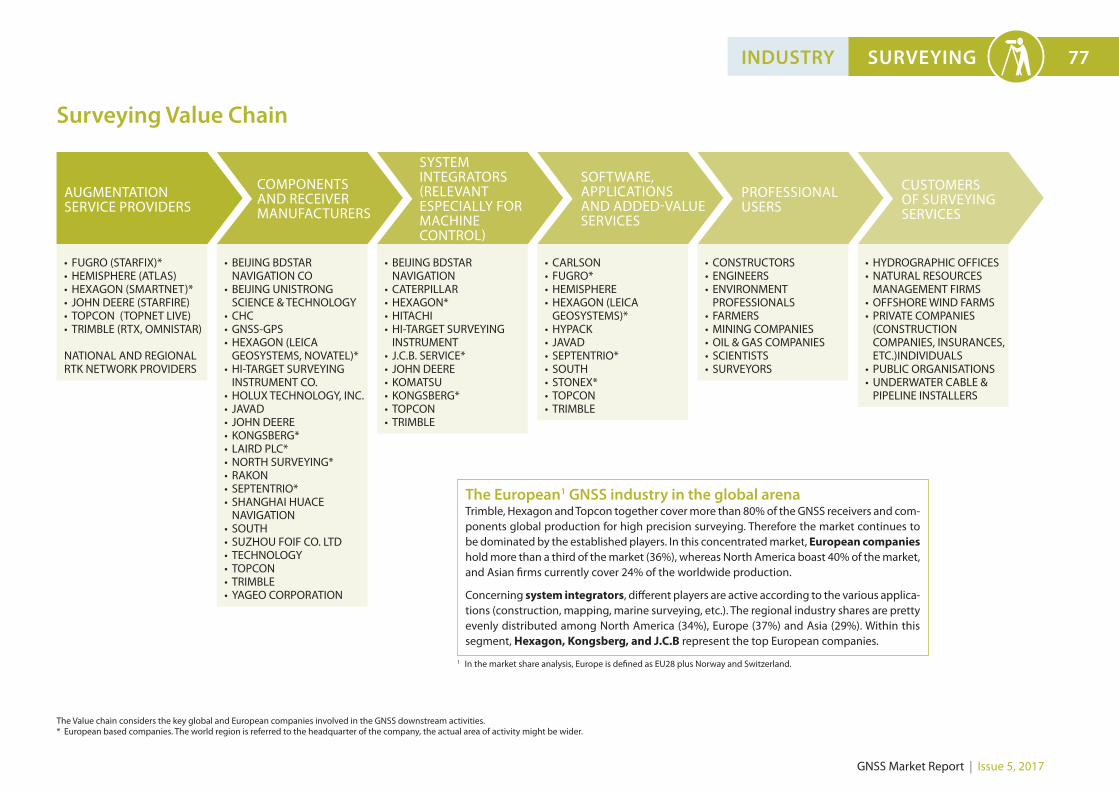
Surveying Value Chain
INDUSTRY
The European1 GNSS industry in the global arenaTrimble, Hexagon and Topcon together cover more than 80% of the GNSS receivers and com-ponents global production for high precision surveying. Therefore the market continues to be dominated by the established players. In this concentrated market, European companies hold more than a third of the market (36%), whereas North America boast 40% of the market, and Asian firms currently cover 24% of the worldwide production.
Concerning system integrators, different players are active according to the various applica-tions (construction, mapping, marine surveying, etc.). The regional industry shares are pretty evenly distributed among North America (34%), Europe (37%) and Asia (29%). Within this segment, Hexagon, Kongsberg, and J.C.B represent the top European companies.
The Value chain considers the key global and European companies involved in the GNSS downstream activities.* European based companies. The world region is referred to the headquarter of the company, the actual area of activity might be wider.
1 In the market share analysis, Europe is defined as EU28 plus Norway and Switzerland.
• FUGRO (STARFIX)*• HEMISPHERE (ATLAS)• HEXAGON (SMARTNET)*• JOHN DEERE (STARFIRE)• TOPCON (TOPNET LIVE)• TRIMBLE (RTX, OMNISTAR) NATIONAL AND REGIONAL RTK NETWORK PROVIDERS
• BEIJING BDSTAR NAVIGATION CO
• BEIJING UNISTRONG SCIENCE & TECHNOLOGY
• CHC• GNSS-GPS• HEXAGON (LEICA
GEOSYSTEMS, NOVATEL)*• HI-TARGET SURVEYING
INSTRUMENT CO.• HOLUX TECHNOLOGY, INC.• JAVAD• JOHN DEERE• KONGSBERG*• LAIRD PLC*• NORTH SURVEYING*• RAKON• SEPTENTRIO*• SHANGHAI HUACE
NAVIGATION• SOUTH• SUZHOU FOIF CO. LTD• TECHNOLOGY • TOPCON• TRIMBLE• YAGEO CORPORATION
• CARLSON• FUGRO*• HEMISPHERE• HEXAGON (LEICA
GEOSYSTEMS)*• HYPACK• JAVAD• SEPTENTRIO*• SOUTH• STONEX*• TOPCON• TRIMBLE
• CONSTRUCTORS• ENGINEERS• ENVIRONMENT
PROFESSIONALS• FARMERS• MINING COMPANIES• OIL & GAS COMPANIES• SCIENTISTS• SURVEYORS
• BEIJING BDSTAR NAVIGATION
• CATERPILLAR• HEXAGON*• HITACHI• HI-TARGET SURVEYING
INSTRUMENT • J.C.B. SERVICE*• JOHN DEERE • KOMATSU• KONGSBERG*• TOPCON• TRIMBLE
• HYDROGRAPHIC OFFICES• NATURAL RESOURCES
MANAGEMENT FIRMS• OFFSHORE WIND FARMS• PRIVATE COMPANIES
(CONSTRUCTION COMPANIES, INSURANCES, ETC.)INDIVIDUALS
• PUBLIC ORGANISATIONS• UNDERWATER CABLE &
PIPELINE INSTALLERS
AUGMENTATION SERVICE PROVIDERS
COMPONENTS AND RECEIVER MANUFACTURERS
SYSTEM INTEGRATORS (RELEVANTESPECIALLY FOR MACHINECONTROL)
SOFTWARE, APPLICATIONS AND ADDED-VALUE SERVICES
PROFESSIONALUSERS
CUSTOMERS OF SURVEYING SERVICES
GNSS Market Report | Issue 5, 2017
78 SURVEYING RECENT DEVELOPMENTS
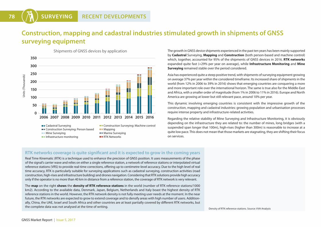
The growth in GNSS device shipments experienced in the past ten years has been mainly supported by Cadastral Surveying, Mapping and Construction (both person-based and machine control) which, together, accounted for 95% of the shipments of GNSS devices in 2016. RTK networks expanded quite fast (+29% per year on average), while Infrastructure Monitoring and Mine Surveying remained stable over the period considered.
Asia has experienced quite a steep positive trend, with shipments of surveying equipment growing on average 37% per year within the considered timeframe. Its increased share of shipments in the world (from 12% in 2006 to 39% in 2016) shows that emerging countries are conquering a more and more important role over the international horizon. The same is true also for the Middle-East and Africa, with a smaller order of magnitude (from 1% in 2006 to 11% in 2016). Europe and North America are growing at lower but still relevant pace, around 10% per year.
This dynamic involving emerging countries is consistent with the impressive growth of the construction, mapping and cadastral industries: growing population and urbanisation processes require intense property and infrastructure-related activities.
Regarding the relative stability of Mine Surveying and Infrastructure Monitoring, it is obviously depending on the infrastructure they are related to: the number of mines, long bridges (with a suspended span longer that 100m), high-rises (higher than 300m) is reasonable to increase at a quite low pace. This does not mean that those markets are stagnating, they are shifting their focus on services.
Construction, mapping and cadastral industries stimulated growth in shipments of GNSS surveying equipment
0
50
100
150
200
250
300
350
Uni
ts (T
hous
ands
)
2006 2007 2008 2009 2010 2011 2012 2013 2014 2015 2016
Cadastral Surveying Construction Surveying: Person based
Construction Surveying: Machine control Mapping
Mine Surveying Marine Surveying Infrastructure monitoring RTK Networks
Shipments of GNSS devices by application
RTK networks coverage is quite significant and it is expected to grow in the coming years Real Time Kinematic (RTK) is a technique used to enhance the precision of GNSS position. It uses measurements of the phase of the signal’s carrier wave and relies on either a single reference station, a network of reference stations or interpolated virtual reference stations (VRS) to provide real-time corrections, offering up to centimetre-level accuracy. Due to the high level of real time accuracy, RTK is particularly suitable for surveying applications such as cadastral surveying, construction activities (road construction, high-rises and infrastructure building) and drones navigation. Considering that RTK solutions provide high accuracy only if the operator is no more than 40 km in distance from a reference station, the coverage of RTK network is very relevant.
The map on the right shows the density of RTK reference stations in the world (number of RTK reference stations/1000 km2). According to the available data, Denmark, Japan, Belgium, Netherlands and Italy boast the highest density of RTK reference stations in the world. However, the RTK network density is not fully meeting user needs at the moment. In the near future, the RTK networks are expected to grow to extend coverage and to densify areas with high number of users. Addition-ally, China, the UAE, Israel and South Africa and other countries are at least partially covered by different RTK networks, but the complete data was not analysed at the time of writing.
Legend
5RTKsta)on/1000km²
3RTKsta)on/1000km²
1RTKsta)on/1000km²
0,5RTKsta)on/1000km²
0,3RTKsta)on/1000km²
0,01RTKsta)on/1000km²Notanalysed
Density of RTK reference stations. Source: VVA Analysis
GNSS Market Report | Issue 5, 2017
SURVEYING 79FUTURE MARKET EVOLUTION
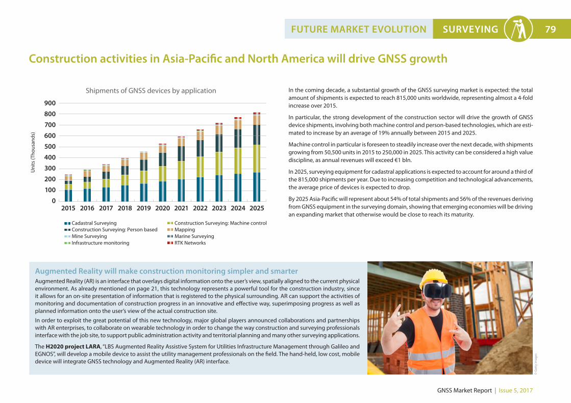
In the coming decade, a substantial growth of the GNSS surveying market is expected: the total amount of shipments is expected to reach 815,000 units worldwide, representing almost a 4-fold increase over 2015.
In particular, the strong development of the construction sector will drive the growth of GNSS device shipments, involving both machine control and person-based technologies, which are esti-mated to increase by an average of 19% annually between 2015 and 2025.
Machine control in particular is foreseen to steadily increase over the next decade, with shipments growing from 50,500 units in 2015 to 250,000 in 2025. This activity can be considered a high value discipline, as annual revenues will exceed €1 bln.
In 2025, surveying equipment for cadastral applications is expected to account for around a third of the 815,000 shipments per year. Due to increasing competition and technological advancements, the average price of devices is expected to drop.
By 2025 Asia-Pacific will represent about 54% of total shipments and 56% of the revenues deriving from GNSS equipment in the surveying domain, showing that emerging economies will be driving an expanding market that otherwise would be close to reach its maturity.
Construction activities in Asia-Pacific and North America will drive GNSS growth
0
100
400
300
200
500
600
700
800
900
Uni
ts (T
hous
ands
)
Cadastral Surveying Construction Surveying: Person based
Construction Surveying: Machine control Mapping
Mine Surveying Marine Surveying Infrastructure monitoring RTK Networks
2015 2016 2018 2019 2020 2021 2022 2023 2024 20252017
Shipments of GNSS devices by application
Augmented Reality will make construction monitoring simpler and smarterAugmented Reality (AR) is an interface that overlays digital information onto the user’s view, spatially aligned to the current physical environment. As already mentioned on page 21, this technology represents a powerful tool for the construction industry, since it allows for an on-site presentation of information that is registered to the physical surrounding. AR can support the activities of monitoring and documentation of construction progress in an innovative and effective way, superimposing progress as well as planned information onto the user’s view of the actual construction site.
In order to exploit the great potential of this new technology, major global players announced collaborations and partnerships with AR enterprises, to collaborate on wearable technology in order to change the way construction and surveying professionals interface with the job site, to support public administration activity and territorial planning and many other surveying applications.
The H2020 project LARA, “LBS Augmented Reality Assistive System for Utilities Infrastructure Management through Galileo and EGNOS”, will develop a mobile device to assist the utility management professionals on the field. The hand-held, low cost, mobile device will integrate GNSS technology and Augmented Reality (AR) interface.
© G
etty
imag
es
GNSS Market Report | Issue 5, 2017
MapKITE project: simultaneous terrestrial and aerial surveying for corridors mapping and smart planningRoadway, railways, waterways and energy pipelines are just some examples of man-made structures for transportation of goods and people. Accurate mapping of their settlements is then fundamental in modern and growing societies, which require accurate terrain mapping, infrastructure maintenance and inspection, cadastral delimitation, city 3D models, etc.
Corridor mapping can now be performed through a novel approach at a lower cost, and this is due to the mapKITE concept. The H2020 project has carried out real corridor mapping missions with a tandem terrestrial-aerial system (mobile mapping vehicle and a drone), achieving tangible, improved results. By using advanced navigation and orientation systems including EGNOS and Galileo E5 AltBOC, mapKITE can substitute conventional surveying-based ground control points at no extra cost. At the time of writing, the mapKITE system has paved its way through the demanding geo-spatial market.
More information on: www.mapkite.com
CLGE Annual Young Surveyors’ Prize: fresh ideas to feed the surveying industry evolutionCecile Deprez is the winner of the 2016 2nd Annual Young Surveyors’ Prize awarded by the European GNSS Agency (GSA) for outstanding contributions to Galileo, EGNOS and Copernicus at the Council of Geodetic Surveyors.
Deprez, a PhD student at the University of Liege in Belgium, proposed an idea poten-tially bringing considerably higher preci-sion to mass-market applications, relying on Google’s provision of access to GNSS raw measurements for Android users. The use of the Galileo E5 signal could theoreti-cally offer decimetre positioning precision for Android applications. According to the winner’s research, Galileo signals are more precise than GPS alone.
In order to support the high-end, demanding surveying applications that seek to maximise the accuracy of measurements and signal availability in harsh environment, it is beneficial to update the augmentation infrastructures to Galileo Open Service capabilities (see below). Additionally, Galileo is set to offer the Commercial Service
High Accuracy (CS-HA) that will meet the level of accuracy required for many applications in cadastral, construction, and mine surveying, while delivering PPP corrections around the world directly via the Galileo satellites (no need for an additional communication channel).
Further benefits of Galileo also include Commercial Service Authentication to ensure the trustwor-thiness of positioning information.
By providing metre level accuracy with minimal investment, EGNOS represents a cost-effective entry level solution. It satisfies the needs of mapping applications requiring enhanced GPS positioning, by providing
added value free of charge.
Municipalities, forestry authorities, utilities and other users benefit from EGNOS performance in mapping. As an example, its advantageous price-quality ratio makes it a suitable technology for the field measurements performed in relation to the Common Agricultural Policy enforcement.
EGNSS set to be key differentiators in mapping and surveying domains
Galileo improves the performance of the RTK and PPP solutionsGalileo’s free-of-charge Open Service offers either single (E1) or dual frequency (E1/E5), which will further improve the quality of the augmentation services as RTK/DGNSS or PPP. The resulting benefits to surveyors include, especially in multi-constellation environments, increased availability of the satellite signals, continuity and reliability, lead to better operation in harsh environments such as urban/natural canyons or under tree canopies.
Following the Initial Services declaration in December 2016, increasingly many private and public network RTK providers, as well as established PPP providers, are offering Galileo corrections to their customers and this trend is expected to grow further.
Third frequency for rangingIn addition to single and dual-frequency capability in the Galileo Open Service, Galileo E6 is available for ranging. This high-quality signal adds an excellent option for the third frequency required for the linear combination of GNSS observations made on three frequencies (e.g. for faster and more reliable ambiguity resolution in RTK and PPP processing).
80 SURVEYING EUROPEAN GNSS
GNSS Market Report | Issue 5, 2017
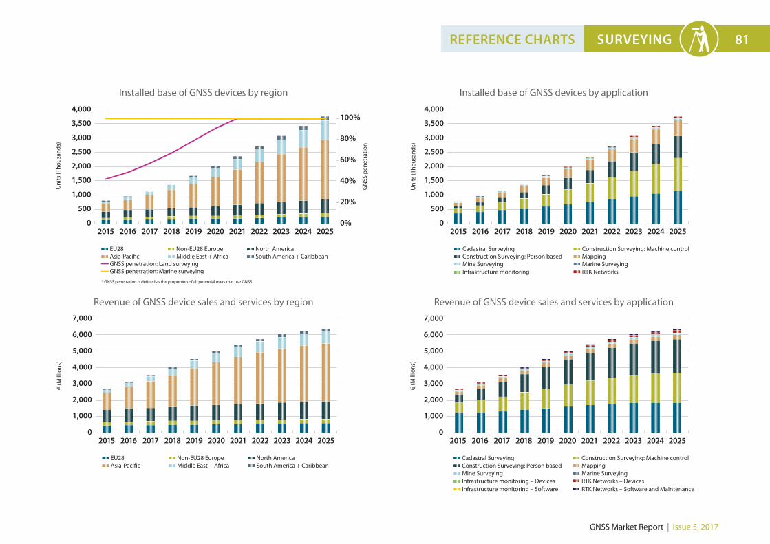
SURVEYING 81REFERENCE CHARTS
0
1,000
500
1,500
2,000
2,500
3,000
3,500
4,000
Uni
ts (T
hous
ands
)
GN
SS p
enet
ratio
n
2015 2016 2017 2018 2019 2020 2021 2022 2023 2024 2025
EU28Asia-Pacific Middle East + Africa
Non-EU28 Europe North America South America + Caribbean
100%
0%
20%
40%
60%
80%
GNSS penetration: Land surveyingGNSS penetration: Marine surveying
* GNSS penetration is defined as the proportion of all potential users that use GNSS
0
1,000
2,000
3,000
4,000
5,000
6,000
7,000
€ (M
illio
ns)
2015 2016 2017 2018 2019 2020 2021 2022 2023 2024 2025
EU28Asia-Pacific Middle East + Africa
Non-EU28 Europe North America South America + Caribbean
0
Uni
ts (T
hous
ands
)
Cadastral Surveying Construction Surveying: Person based
Construction Surveying: Machine control Mapping
Mine Surveying Marine Surveying Infrastructure monitoring RTK Networks
2015 2016 2018 2019 2020 2021 2022 2023 2024 20252017
1,000
500
1,500
2,000
2,500
3,000
3,500
4,000
0
€ (M
illio
ns)
Cadastral Surveying Construction Surveying: Person based
Construction Surveying: Machine control Mapping
Mine Surveying Marine Surveying Infrastructure monitoring – Devices RTK Networks – Devices Infrastructure monitoring – Software RTK Networks – Software and Maintenance
2015 2016 2018 2019 2020 2021 2022 2023 2024 20252017
1,000
2,000
3,000
4,000
5,000
6,000
7,000
Installed base of GNSS devices by region
Revenue of GNSS device sales and services by region
Installed base of GNSS devices by application
Revenue of GNSS device sales and services by application