combination of inertial survey systems and gnss for surveying · combination of inertial survey...
TRANSCRIPT

Combination of Inertial Survey Systems and GNSS for Surveying
Milena [email protected]
Imego - Part of Swedish ICT
CGSIC, 27 Oct 2009
Milena Anguelova, CGSIC 27 oct 2009

Overview
Introduction• Imego in general• Imego’s inertial sensors, systems and applications
GNSS + INS• Comparison GNSS / Inertial Navigation Systems (INS)• GPS Shadow Explorer (2004)• Performance now and in the future
Milena Anguelova, CGSIC 27 oct 2009

Imego: a research institute focusing on microsensors, sensor systems and prototype development
Milena Anguelova, CGSIC 27 oct 2009

Imego’s applications in motion tracking
Surveying
Drill hole measurement Fireman localization
Crash tests
Rocket navigation
+ Other applications
Sport
Milena Anguelova, CGSIC 27 oct 2009

IMT40
Imego’s IMU-history IMU = Inertial Measurement Unit
IMT30
IMT 6000GyroSmart
Milena Anguelova, CGSIC 27 oct 2009

x-zy-z
x
yz
Imego’s inertial sensors with MEMS-technology
Gyroscopes – measure angular velocity
Accelerometers- measure linear acceleration
Milena Anguelova, CGSIC 27 oct 2009

Gyro technologies
ImegoImego
idagidag
xx
ImegoImego
tomorrow
tomorrow
Imego
2004ImegoImego
20042004
Milena Anguelova, CGSIC 27 oct 2009

Overview
Milena Anguelova, CGSIC 27 oct 2009
Introduction• Imego in general• Imego’s inertial sensors, systems and applications
GNSS + INS• Comparison GNSS / Inertial Navigation Systems (INS)• GPS Shadow Explorer (2004)• Performance now and in the future

GNSS compared to INS
Satellite navigation– Absolute position data– Limited resolution– Slow– Worse at orientation– Easily disturbed– Best at X&Y
Inertial navigation– Drift in integrated terms– High resolution (rel.)– Fast (kHz)– Best at orientation– Disturbance-free (no
external ref)– Best at Z
- complement eachother well!
Milena Anguelova, CGSIC 27 oct 2009

GPS Shadow Explorer (2004)
• Demonstrator• With Lantmäteriet (National Land Survey) and other
governmental inst.• Inertial navigation used during GNSS/RTK shadow
intervals• Light and (relatively) inexpensive

= GPS= GPS--datadata
= INS= INS--datadata
GPS Shadow Explorer (2004)
IMUKnown start- and end-point
Milena Anguelova, CGSIC 27 oct 2009

GPS Shadow Explorer (2004)• Two reference courses with a number of measured points 5/10 m apart
IMEGOIMEGO
50 m
N • Measuring rod is held at the known-point markers
• Pauses appr. 2 s • 5/10 s between points• Known start- and end-
points, inbetween GPS-shadow
Milena Anguelova, CGSIC 27 oct 2009

GPS
Sha
dow
exp
lore
r
Milena Anguelova, CGSIC 27 oct 2009

Navigation software
• Kalman filter• Pauses identified• ZUPT - zero velocity update
– recalibration of offset-values of gyros and accelerometers– at pauses when measuring rod is held fixed on the ground
• Navigation performed between pauses• Coordinates of start- and end-points known (GPS)
Milena Anguelova, CGSIC 27 oct 2009
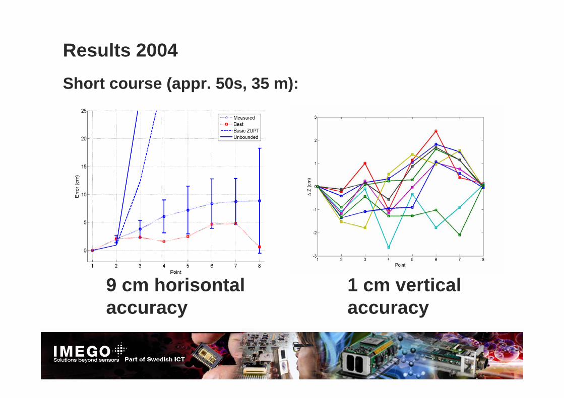
Results 2004
9 cm horisontalaccuracy
1 cm vertical accuracy
Short course (appr. 50s, 35 m):
Milena Anguelova, CGSIC 27 oct 2009
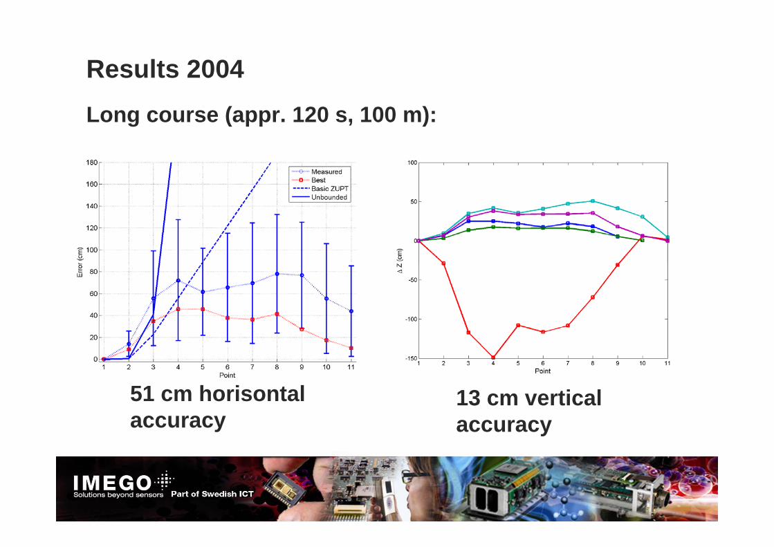
Results 2004Long course (appr. 120 s, 100 m):
51 cm horisontal accuracy
13 cm vertical accuracy
Milena Anguelova, CGSIC 27 oct 2009

Then, Now, Tomorrow• GPS Shadow Explorer 2004
– Analog gyroelectronics and 30 deg/h bias-stability– 51 / 13 cm (h/v) error after 120 s with known start- and end-points
• Present generation’s digital IMU (2009)– IBG20/21 gyros with appr. 1-3 deg/h bias-stability– 5 / 2 cm (h/v) error after 100 s without known end-point
• Next generation gyros (under development)– Goal: appr. 10 times better performance
• Tight integration between INS and GNSS– INS used to support GNSS’s phase tracking
Milena Anguelova, CGSIC 27 oct 2009

Personal navigation – fireman localization
• In buildings – only inertial navigation• Inertial sensors on foot
⇒ Drift can be set to zero at every step
Milena Anguelova, CGSIC 27 oct 2009

Milena Anguelova, CGSIC 27 oct 2009
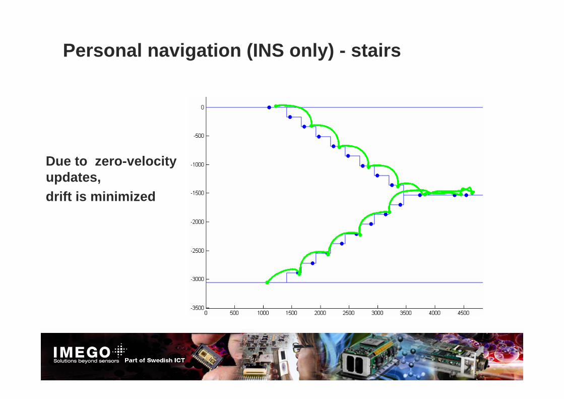
Personal navigation (INS only) - stairs
Due to zero-velocity updates,drift is minimized
Milena Anguelova, CGSIC 27 oct 2009