structure plan - golden plains shire · 7.4 implementation table 32 8. monitoring and review 36....
TRANSCRIPT
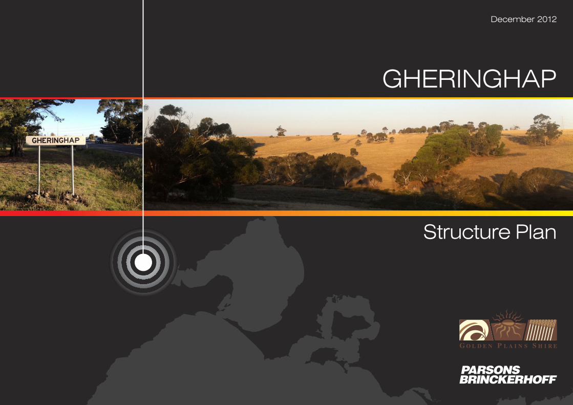
GHERINGHAP
Structure Plan
December 2012
GHERINGHAP STRUCTURE PLAN
Revision Details Date Amended By
00 Original
01 Amendments 8/06/12 P Dawson
02 Amendments 29/06/12 P Dawson
03 Amendments 15/11/12 P Dawson
©Parsons Brinckerhoff Australia Pty Limited (PB) [2012].
Copyright in the drawings, information and data recorded in this document (the information) is the property of PB. This document and the information are solely for the use of the authorised recipientand this document may not be used, copied or reproduced in whole or part for any purpose other than that for which it was supplied by PB. PB makes no representation, undertakes no duty andaccepts no responsibility to any third party who may use or rely upon this document or the information.
Author: Peter Dawson, Emma Lichkus
Signed:
Reviewer: Marc Bartsch
Signed:
Approved by: Peter Dawson
Signed:
Date: 17 May 2012
Gheringhap Structure Plan
Page i GHERINGHAP STRUCTURE PLAN
Contents
Page number
1. Introduction 1
1.1 Purpose and objectives 1
1.2 Boundary 1
1.3 Vision 3
1.4 Implementation 3
1.5 Report Structure 3
2. Regional role, environment and existing conditions 4
2.1 Metropolitan and regional context 4
2.1.1 Regional trends 52.2 Local context 6
2.2.1 Land use and topography 62.2.2 Environment 62.2.3 Heritage and culture 82.2.4 Demographics 82.2.5 Employment 82.2.6 Transport 82.2.7 Infrastructure 92.2.8 Recreation and community facilities 10
3. Policy context 11
3.1 Strategic direction 11
3.2 Directions for Gheringhap 14
4. Community and stakeholder engagement 15
4.1 Community feedback 16
4.2 Stakeholder feedback 17
5. Vision for Gheringhap 19
5.1 Strengths, Weaknesses, Opportunities and Threats 19
5.2 The Vision 21
5.3 Scenarios 21
5.3.1 Preferred Scenario 22
6. Planning for Gheringhap – strategic response 24
6.1 Guiding principles 24
7. Implementation 30
7.1 Implementation Actions 30
7.2 Planning scheme changes 30
7.3 Developer Contributions 31
7.4 Implementation table 32
8. Monitoring and review 36
Gheringhap Structure Plan
Page ii GHERINGHAP STRUCTURE PLAN
List of tablesPage number
Table 1 Scenario assessment 23Table 2 Implementation Table 35
List of figuresFigure 1 Gheringhap Structure Plan Area 2Figure 2 Regional Context 4Figure 3 View from Bakers Bridge Road, looking west 7Figure 4 View towards the bridge over the railway line, looking north-east 7Figure 5 View towards the bridge over the railway line, looking north-east 10Figure 6 View to north-east to tennis courts at Gheringhap 10Figure 7 Community and stakeholder consultation process 15Figure 8 Methodology for SWOT analysis 18Figure 9 Developing the vision 20Figure 10 Gheringhap Land Use Framework Plan 24Figure 11 Gheringhap Constraints/Commitment Plan 25Figure 12 Example design guidelines – Frontage Treatment 26Figure 13 Example design guidelines – Rear Boundary Treatment 26Figure 14 Example design guidelines – Setbacks 27Figure 15 Proposed future access arrangements 28
AppendicesAppendix A - Flora, Fauna and Cultural Heritage DetailsAppendix B - Infrastructure Details
Gheringhap Structure Plan
Page 1 GHERINGHAP STRUCTURE PLAN
1 In
trod
uctio
n
1. Introduction
1.1 Purpose and objectives
This Structure Plan has been prepared by theGolden Plains Shire with input from the localcommunity, key stakeholders, governmentagencies and service providers.
The Gheringhap Structure Plan sets out the longterm vision to guide future development providing aclear plan for the future. The Plan identifies: thetype and form of development that should beencouraged in Gheringhap; the areas in whichdevelopment should be directed; and identifiesinfrastructure and services upgrades required tomeet the overall vision for the area.
The Golden Plains Planning Scheme MunicipalStrategic Statement (MSS) as identified in thePlanning Scheme provides clear direction regardingthe required content of Structure Plans. This isstated as follows:
“a preferred layout of residential,commercial, community and other land usesbased on a ten (10) year outlook. Thestructure plans are designed to meet a variety ofobjectives including quality of lifestyle,environmental quality, and economic andquality tourist opportunities. The opportunityfor coordinated town improvements, in terms ofthe location, appearance and servicing of useand development, has also been identified.”Golden Plains Planning Scheme Clause 21.03.
This Structure Plan has been informed by thefollowing:
Community and key stakeholder views toassist in identifying opportunities, constraintsand developing an overall vision for the area.
Information provided by key service providersto identify the capacity of existing services andthe need for future services and facilities
Technical studies including a Flora and Faunaand Heritage Study and an EngineeringServices Assessment prepared for the project
Key strategies and policies including:
Gheringhap Development Review Study,1996
Review of South-East Area Golden PlainsShire, 2007
Golden Plains Rural Land Use Strategy,2008
Revised Bannockburn Urban DesignFramework 2011
Golden Plains Shire Planning Scheme
Background studies including:
Geelong Regional Airport FeasibilityStudy, 2011
Geelong Intermodal Freight TerminalFeasibility Study, 2007
1.2 Boundary
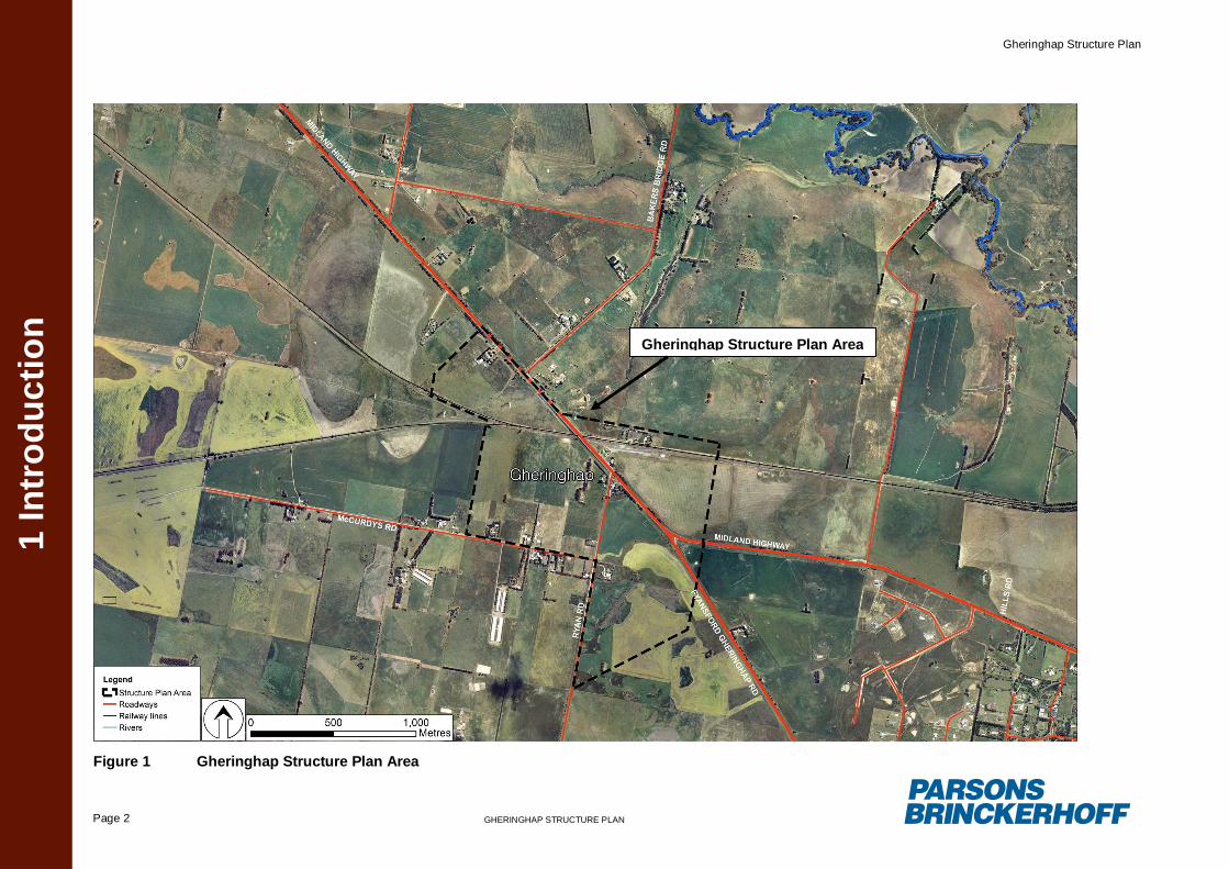
The Gheringhap Structure Plan area is shown onFigure 1
The area is irregular in shape as it takes in toconsideration a number of existing constraints andconditions in the locality. It also accounts forvarious strategic decisions already committed to inprevious planning studies including the ‘Review ofthe south-east area Golden Plains Shire’.The Structure Plan area encompasses 14 lots andhas an area of approximately 173ha.
Gheringhap Structure Plan
Page 2 GHERINGHAP STRUCTURE PLAN
1 In
trod
uctio
n
Figure 1 Gheringhap Structure Plan Area
Gheringhap Structure Plan Area
Gheringhap Structure Plan
Page 3 GHERINGHAP STRUCTURE PLAN
1 In
trod
uctio
n
1.3 Vision
The overall vision for Gheringhap has beendeveloped through a review of backgroundmaterial, policies, strategies and community andstakeholder consultation. The vision statement isas follows:
To balance the rural character and lifestyle ofGheringhap while providing for future businessopportunities and community facilities that areappropriately located, sited and designed so toprotect the rural, natural and amenity features ofthe area.
The 10 principles supporting this overarching visionstatement are as follows. These are explained inmore detail in Section 6 of this Structure Plan.
1. Encourage a ‘planned’ approach todevelopment, avoiding ad hoc decisions.
2. Limit development on parcels of land whichhave existing constraints/commitments.
3. Protect existing assets and infrastructure.Maximise the opportunities that theseservices provide for businesses, thecommunity and the region as a whole.
4. Ensure that the costs of the development aremet by those who benefit.
5. Consider the existing character of theGheringhap environment.
6. Provide for the development of business andcommercial activities which do not
adversely affect the safety and amenity ofthe local community.
7. Increase the safety of the existing roadnetwork.
8. Discourage residential development on landdesignated for employment.
9. Protect existing industry and employmentactivities. Avoid constraining their potential.
10. Provide for flexibility, allowing Gheringhapto respond to changes in demand andgrowth. Assist in ensuring that thecommunity remains resilient over time.
1.4 Implementation
A major consideration in the completion of thisproject has been the need to provide a flexible anddynamic strategic Plan that recognises the existingcapability of Gheringhap and the key influences onits growth. The projected growth within Geelongand the anticipated development of Bannockburnand Batesford, will substantially determine thecapability of Gheringhap to develop as a keyemployment area. There is also a need to protectthe economic and social development within thesetownships, and avoid any competition foremployment development.
A further consideration in the implementation of thePlan is that although Gheringhap has major utilitiesin close proximity, these services requiresubstantial capital investment to provide for accessand augmentation of the individual utility system.
1.5 Report Structure
This Structure Plan includes the following Sections:
Section 2 Regional role, environment andexisting conditions
Section 3 Policy context
Section 4 Community and StakeholderEngagement
Section 5 Vision for Gheringhap
Section 6 Planning for Gheringhap – StrategicResponse
Section 7 Implementation
Section 8 Monitoring and Review
This Structure Plan has been informed bycompletion of a comprehensive literature review,completion of a SWOT analysis and throughconsultation with key stakeholders and thecommunity.
Gheringhap Structure Plan
Page 4 GHERINGHAP STRUCTURE PLAN2. R
egio
nal R
ole,
env
ironm
ent a
nd e
xist
ing
cond
ition
s
2. Regional role,environment and existingconditions
2.1 Metropolitan and regionalcontext
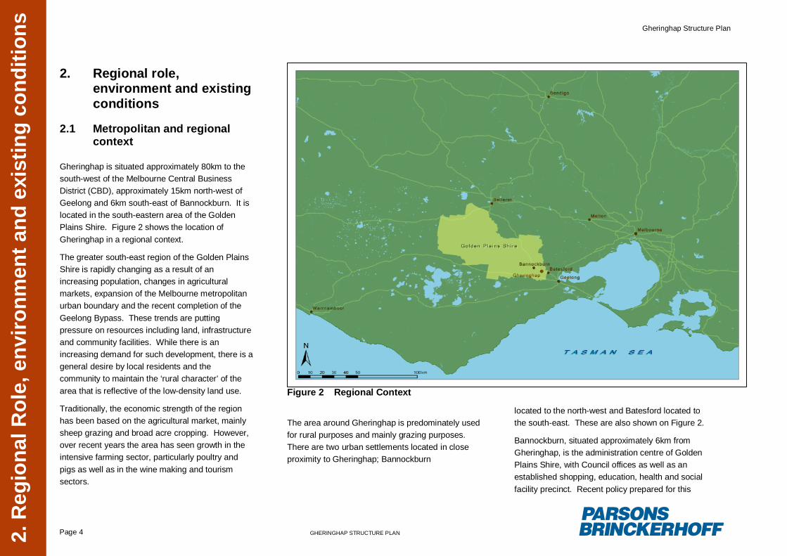
Gheringhap is situated approximately 80km to thesouth-west of the Melbourne Central BusinessDistrict (CBD), approximately 15km north-west ofGeelong and 6km south-east of Bannockburn. It islocated in the south-eastern area of the GoldenPlains Shire. Figure 2 shows the location ofGheringhap in a regional context.
The greater south-east region of the Golden PlainsShire is rapidly changing as a result of anincreasing population, changes in agriculturalmarkets, expansion of the Melbourne metropolitanurban boundary and the recent completion of theGeelong Bypass. These trends are puttingpressure on resources including land, infrastructureand community facilities. While there is anincreasing demand for such development, there is ageneral desire by local residents and thecommunity to maintain the ‘rural character’ of thearea that is reflective of the low-density land use.
Traditionally, the economic strength of the regionhas been based on the agricultural market, mainlysheep grazing and broad acre cropping. However,over recent years the area has seen growth in theintensive farming sector, particularly poultry andpigs as well as in the wine making and tourismsectors.
Figure 2 Regional Context
The area around Gheringhap is predominately usedfor rural purposes and mainly grazing purposes.There are two urban settlements located in closeproximity to Gheringhap; Bannockburn
located to the north-west and Batesford located tothe south-east. These are also shown on Figure 2.
Bannockburn, situated approximately 6km fromGheringhap, is the administration centre of GoldenPlains Shire, with Council offices as well as anestablished shopping, education, health and socialfacility precinct. Recent policy prepared for this
Gheringhap Structure Plan
Page 5 GHERINGHAP STRUCTURE PLAN2. R
egio
nal R
ole,
env
ironm
ent a
nd e
xist
ing
cond
ition
s
area including the Revised Bannockburn UrbanDesign Framework 2011, seeks to furtheremphasise the role of Bannockburn as the majorcentre making provision for further residential andcommercial growth and development. TheBannockburn township is the primary source ofcommercial, community and recreation facilities forGheringhap.
Batesford is a smaller township located to thesouth-east of Gheringhap. Both Bannockburn andBatesford are designated areas where futuregrowth and development is to be focused, as notedin the Bannockburn Urban Design Framework andthe Batesford Framework Plan. The provision ofnew services, facilities and infrastructureassociated with residential growth is also to bedirected to these areas.
2.1.1 Regional trends
There are a number of key trends which areinfluencing the Shire’s rural assets which havebeen considered as part of this Structure Plan.These are as follows:
Increasing demand for land, as pressurearises following the construction of theGeelong Bypass. This is primarily in regard tobetter access to key infrastructure andlocations, for example, Geelong andMelbourne.
Loss of agricultural land through subdivisionfor rural-residential sized lots. This is now
more effectively managed and its impact isless apparent.
Steady population growth over the last 15years, with the majority of the populationconcentrated in the south-east, within existingtownships (i.e., Bannockburn). With populationgrowth comes community requirements andexpectations in regards to access to suitableservices and facilities in close proximity.
Increasing demand for residential and rural-living development in the areas surroundingGheringhap, particularly Bannockburn andBatesford. This has resulted in a trend ofcreating and selling small individual lots withlimited agricultural productivity, but offering anincreased range of lifestyle opportunities.
It is expected based on economic projectionsthat the demand for lower priced rural-residential lots will increase in the south-eastregion. This is partly due to the lower landprice for larger sized allotments in theselocations.
Growth in the intensive agricultural industry,particularly specialist livestock and winemaking.
Given the high demand for land in the area,rural land prices are increasing, reducing theattractiveness of the area for agriculturalpurposes. This was confirmed by farmers whoowned land in Gheringhap and were unable to
afford to expand their holding to increaseproduction.
Depletion and loss of native vegetation hasresulted in the reduction in biodiversity values.
Protection of natural resources, the waterquality in rivers and streams and theprotection of the Shire’s landscape assets.Inappropriate land use patterns such asvegetation clearance and polluted runoff arecontributing to the water quality issues withinthe Shire. Increased attention to landcareprojects and the extension of vegetationcorridors along rivers and creeks is required.
Economic projections indicate the potential ofgrowth in employment levels in the Shireattributed to increasing accessibility and theindirect benefits as a result of the constructionof major infrastructure (i.e., the GeelongBypass).
Lack of water supply and restrictions in someareas. Upgrades are likely to be required toaccommodate future growth. Considerationneeds to be given to the additional waterconsumption needs of piggeries, broiler farmsand other agricultural industries.
Community desire to maintain the ‘rurallifestyle’ and ‘non-urban’ breaks betweendesignated rural townships. There is howeveran expectation for a certain level of social andphysical infrastructure to be provided withinthe Shire. Issues arise when development is

Gheringhap Structure Plan
Page 6 GHERINGHAP STRUCTURE PLAN2. R
egio
nal R
ole,
env
ironm
ent a
nd e
xist
ing
cond
ition
s
isolated or dispersed (i.e., limited access toexisting infrastructure).
The south east area has a number ofinfrastructure and locational attributes that willprove to be attractive to certain forms ofdevelopment.
These trends are relevant to the Gheringhaplocality as they influence the demand for land,facilities and resources, which will ultimately impacton the overall direction for the area. It is importantthat this Structure Plan recognises and addressesthese trends to ensure the overall plan forGheringhap is reflective of the regional context.This is dealt with in further details in Sections 5through to Section 7.
2.2 Local context
2.2.1 Land use and topography
Gheringhap is a small rural settlement situatednorth and south of the Midland Highway and thestandard gauge railway. The railway and highwaybisects the settlement into two parts, with themajority of the existing residential (rural-living styledevelopment) and agricultural developmentoccurring to the south.
The general topography of the area to the north ofthe railway line is flat up to approximately 2-3kmnorth of the Midland Highway, after which theMoorabool River corridor creates a significantintrusion into the plain, with undulating valleys. To
the south of the Midland Highway the land isgenerally flat and with minor variations in slope.
There is no conventional residential developmentwithin Gheringhap, however, there are pockets ofrural-living type development; one located at thenorthern end of Ryan Road near the MidlandHighway; and one along a 1200 meter stretch ofMcCurdys Road, south of the Midland Highway. Allland within the Structure Plan area is zonedFarming Zone (FZ).
Historically the land within the Gheringhap localityhas been used for agricultural purposes, mainlybroadacre sheep, cattle grazing and cropping.However, the area has been recently noted ashaving poor soil quality, meaning that the majorityof the area is unsuitable for intensive agriculturalactivities. Over time there has also been anexpansion into intensive animal industry such aspoultry farming, with these activities generallylocated to the south of the Midland Highway,around McCurdys Road and Booleys Road.
The development of poultry farms in these locationshas resulted, in some cases, with a sensitive landuse (i.e. residential) being located in close proximityto these farms. There is a need to recognise andmanage any potential conflicts between these twoland uses, avoiding adverse impacts on the amenityvalues of residential land uses. It is noted thatwhile current planning guidelines (Poultry FarmingPlanning Guide) recommend a minimum 500mbuffer between sensitive land uses such asresidential development and poultry farms,development prior to these polices has resulted insome houses being located as close as 100m from
existing poultry farms (i.e. development within thevicinity of McCurdys Road). This conflict needs tobe managed and further development which wouldcompound this issue should be discouraged.
There are no other significant land uses within theGheringhap locality.
2.2.2 Environment
Character and setting
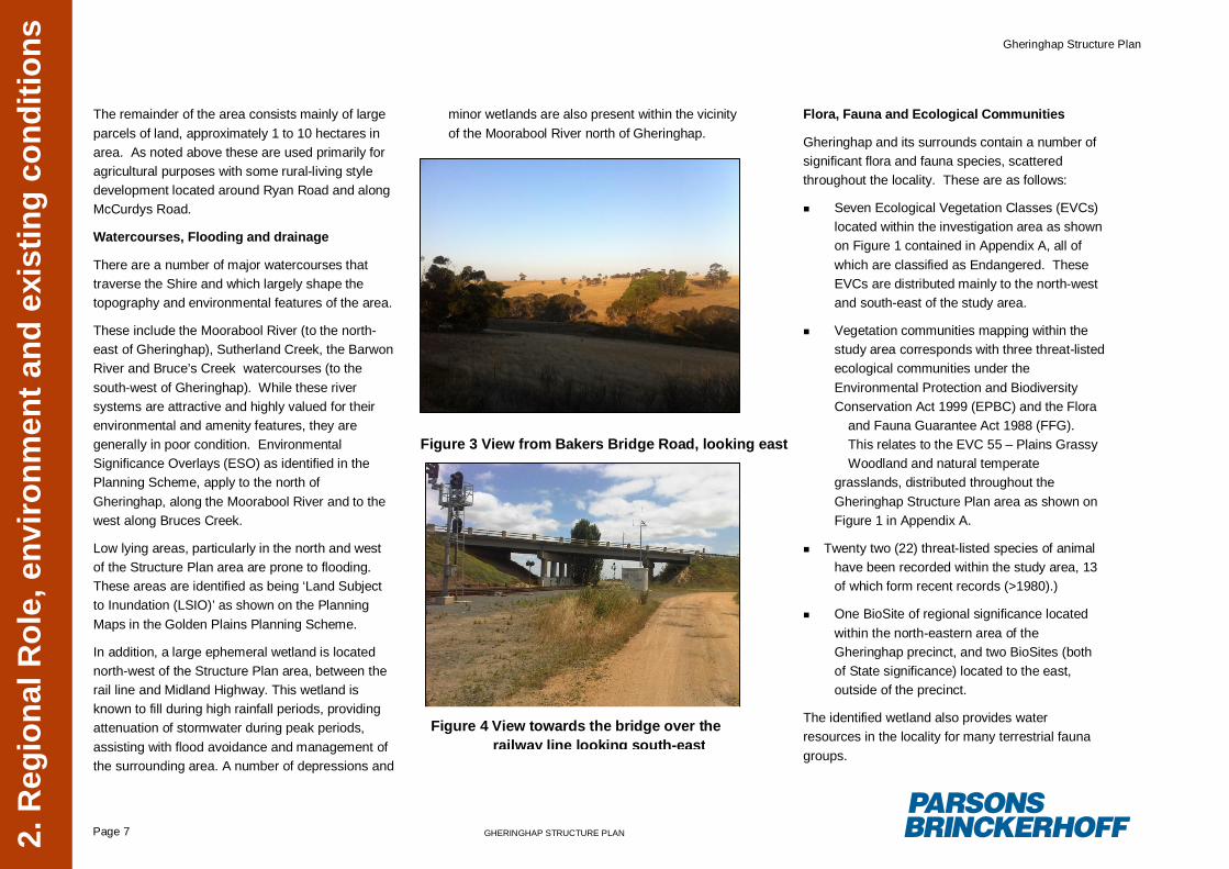
Land within Gheringhap is relatively flat with muchof the land previously cleared of vegetation. Theflat open plains are considered by the localcommunity to be a defining feature of Gheringhapand the wider Golden Plains south-eastern region.Figure 3 shows the view from Bakers Bridge Road,looking east over the northern area of theGheringhap precinct across the valley of theMoorabool River.
Other identifiable features include a largeephemeral wetland located between the railway lineand the Midland Highway. This wetland is known tofill during rainfall periods, providing water resourcesin the locality for many terrestrial fauna groups. Inaddition, there is a small dam located to the north ofthe Midland Highway, south of Bakers Bridge Road,which provides a water source for livestock.
The grade separation of the Midland Highway andthe Geelong- Ballarat railway line is an identifiableand defining element of the township. This isshown in Figure 4.
Gheringhap Structure Plan
Page 7 GHERINGHAP STRUCTURE PLAN2. R
egio
nal R
ole,
env
ironm
ent a
nd e
xist
ing
cond
ition
s
The remainder of the area consists mainly of largeparcels of land, approximately 1 to 10 hectares inarea. As noted above these are used primarily foragricultural purposes with some rural-living styledevelopment located around Ryan Road and alongMcCurdys Road.
Watercourses, Flooding and drainage
There are a number of major watercourses thattraverse the Shire and which largely shape thetopography and environmental features of the area.
These include the Moorabool River (to the north-east of Gheringhap), Sutherland Creek, the BarwonRiver and Bruce’s Creek watercourses (to thesouth-west of Gheringhap). While these riversystems are attractive and highly valued for theirenvironmental and amenity features, they aregenerally in poor condition. EnvironmentalSignificance Overlays (ESO) as identified in thePlanning Scheme, apply to the north ofGheringhap, along the Moorabool River and to thewest along Bruces Creek.
Low lying areas, particularly in the north and westof the Structure Plan area are prone to flooding.These areas are identified as being ‘Land Subjectto Inundation (LSIO)’ as shown on the PlanningMaps in the Golden Plains Planning Scheme.
In addition, a large ephemeral wetland is locatednorth-west of the Structure Plan area, between therail line and Midland Highway. This wetland isknown to fill during high rainfall periods, providingattenuation of stormwater during peak periods,assisting with flood avoidance and management ofthe surrounding area. A number of depressions and
minor wetlands are also present within the vicinityof the Moorabool River north of Gheringhap.
Flora, Fauna and Ecological Communities
Gheringhap and its surrounds contain a number ofsignificant flora and fauna species, scatteredthroughout the locality. These are as follows:
Seven Ecological Vegetation Classes (EVCs)located within the investigation area as shownon Figure 1 contained in Appendix A, all ofwhich are classified as Endangered. TheseEVCs are distributed mainly to the north-westand south-east of the study area.
Vegetation communities mapping within thestudy area corresponds with three threat-listedecological communities under theEnvironmental Protection and BiodiversityConservation Act 1999 (EPBC) and the Flora
and Fauna Guarantee Act 1988 (FFG).This relates to the EVC 55 – Plains GrassyWoodland and natural temperate
grasslands, distributed throughout theGheringhap Structure Plan area as shown onFigure 1 in Appendix A.
Twenty two (22) threat-listed species of animalhave been recorded within the study area, 13of which form recent records (>1980).)
One BioSite of regional significance locatedwithin the north-eastern area of theGheringhap precinct, and two BioSites (bothof State significance) located to the east,outside of the precinct.
The identified wetland also provides waterresources in the locality for many terrestrial faunagroups.
Figure 3 View from Bakers Bridge Road, looking east
Figure 4 View towards the bridge over therailway line looking south-east
Gheringhap Structure Plan
Page 8 GHERINGHAP STRUCTURE PLAN2. R
egio
nal R
ole,
env
ironm
ent a
nd e
xist
ing
cond
ition
s
It is noted that these areas have been mapped at ahigh level and that further on-ground investigationswill need to be undertaken to confirm the presence,and the precise location of these species. This willneed to be undertaken at the time of consideringspecific development proposals within the mappedareas.
2.2.3 Heritage and culture
A review of the Department of Sustainability andEnvironment (DSE) data layer shows an area ofcultural heritage sensitivity, located within thenorthern portion of the Gheringhap locality. This isbased on sensitive attributes such as proximity towater courses, known aboriginal sites and/or otherareas of cultural heritage significance. Anydevelopment proposals within this area will besubject to a requirement to prepare a CulturalHeritage Management Plan (CHMP) unless it has aspecific exemption under the Victorian AboriginalHeritage Act 2006.
There are also a number of historicalarchaeological sites located to the north, south andeast of the Gheringhap locality, however these arelocated outside of the Gheringhap Structure Planarea. See Figure 2 in Appendix A for details.
Whilst there are a number of local heritagesignificant properties in the vicinity of the StructurePlan area, there are no World Heritage propertiesor National Heritage places.
2.2.4 Demographics
The Gheringhap locality is a small rural settlementwith a total of 47 houses located on 122 parcels ofland. While there has been rapid growth within thesouth-east region as a whole, the rate ofdevelopment within Gheringhap is slow, with only 3dwellings constructed in the past 5 years and nonew development in the past 2 years.
Within the Structure Plan area, it has beendetermined that there are 8 houses located on 16different lots. The total population is thereforeconsidered to be approximately 20 people based onthe assumption that there are 2.5 persons perhousehold 1.
It is expected that this number will not dramaticallyincrease in the foreseeable future.
2.2.5 Employment
Traditionally agriculture has been the economicstrength of the south-east region of Golden PlainsShire, for primary production (mostly drylandfarming), sheep grazing and broad acre cropping aswell as intensive animal industries such as poultryand some viticultural industries. However, it isnoted that while there are a number of productiveagricultural enterprises in the region, theseactivities do not provide sufficient employmentopportunities for the region as a whole and there isa high reliance on off-farm income with residents
1 Australian Bureau of Statistics, Household andFamily Projections Australia 2021 to 2026
commuting to areas outside of the Shire (i.e.,Geelong) for work opportunities.
This situation has been confirmed by local residentswho, during the consultation processes undertakenfor the preparation of this Structure Plan, haveconfirmed that Geelong and Bannockburn, and insome cases Melbourne, are the primary locationsfor employment. Gheringhap residents typicallytravel to these locations on a daily basis to accesswork.
The significance of the projected growth inindustrial land use within Geelong is that whenthere is major competition for development siteswithin industrial areas, the attractiveness ofalternative sites such as Gheringhap is increased.This is due to the price of land within Gheringhapbeing considered to be cheaper than in Geelong.
2.2.6 Transport
Gheringhap is situated in relatively close proximityto Geelong and has good access to the GeelongRing Road, the Hamilton Highway and the Port ofGeelong.
The Midland Highway and the Fyansford-Gheringhap Road both serve as significant roadlinks, providing access between Geelong andBallarat.
Local access roads within Gheringhap include:Ryan Road, which extends directly off the MidlandHighway to the south; McCurdys Road whichextends off Ryan Road to the west; and BakersBridge Road which connects to the Midland
Gheringhap Structure Plan
Page 9 GHERINGHAP STRUCTURE PLAN2. R
egio
nal R
ole,
env
ironm
ent a
nd e
xist
ing
cond
ition
s
Highway from the north. These local roads consistof sealed pavements which are adequate for lowvehicle traffic volumes. While it is noted that someof these roads are used by trucks servicing theexisting agricultural activities in the area, upgradesare likely to be required in the event that anysubstantial development occurs in the area.
A bus service runs between Geelong and Ballaratand stops at Gheringhap four times a day.
The standard gauge railway line, which runsthrough the centre of the study area, providesaccess to Geelong, Ballarat and other areas withinAustralia. The railway line is an important regionalrail link, and has the potential to be used for futureadditional freight and passenger services. It is alsonationally significant as it connects Melbourne toother major cities including Adelaide and Perth.
It is noted that there is no existing station or stopwithin Gheringhap. There is however, an existingsiding to the north of the Midland Highway used inan operational capacity.
Given the train line currently provides a major pieceof infrastructure, it was considered as part of thisstructure planning process in terms of providingopportunities for the development of land adjacentthe train line for activities which require rail access.Advice was sought from the Department ofTransport (DoT), in relation to potentialdevelopment opportunities and whether or not theywould support such development. At this time, theDoT would generally support development adjacentto the railway and within the Structure Plan area.Any future development proposals would be
assessed on merit and the associated impact onthe rail infrastructure at the time of application.
It was also noted that any new developmentproposed in the area should be designed so that itdoes not jeopardise the existing and futureoperations of the railway system. Developmentwould therefore need to respond to existing amenityimpacts of train operations including noise
2.2.7 Infrastructure
The study area has significant strategicinfrastructure assets which serve regional and statefunctions See Figure 1 and 2 in Appendix B fordetails of these assets. In summary, these are asfollows:
A 500mm diameter high pressure gaspipeline, with APA Gasnet being the owner ofthis asset. The pipeline runs east to westcrossing over Steiglitz Road and MooraboolRiver before changing direction, headingsouth-west, crossing the Geelong and BallaratRail Line, the Midland Highway andFyansford-Gheringhap Road. The pipelinethen continues south-west towards theHamilton Highway.
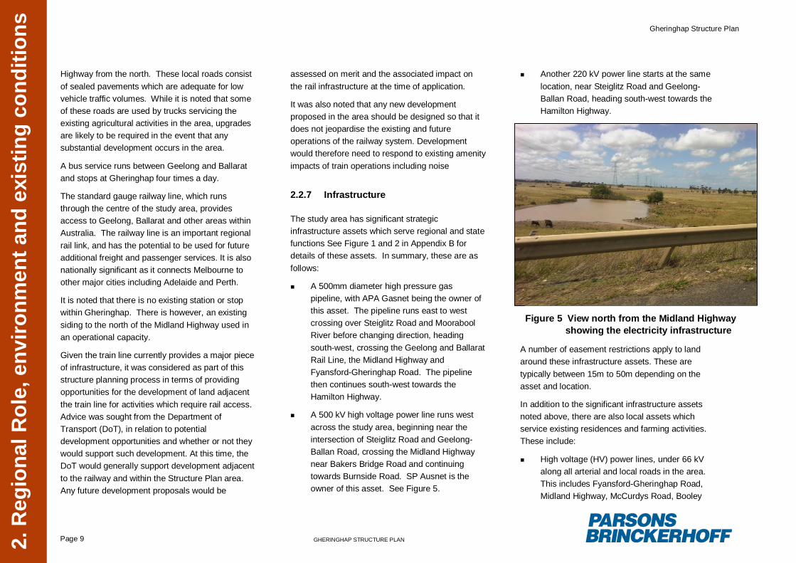
A 500 kV high voltage power line runs westacross the study area, beginning near theintersection of Steiglitz Road and Geelong-Ballan Road, crossing the Midland Highwaynear Bakers Bridge Road and continuingtowards Burnside Road. SP Ausnet is theowner of this asset. See Figure 5.
Another 220 kV power line starts at the samelocation, near Steiglitz Road and Geelong-Ballan Road, heading south-west towards theHamilton Highway.
A number of easement restrictions apply to landaround these infrastructure assets. These aretypically between 15m to 50m depending on theasset and location.
In addition to the significant infrastructure assetsnoted above, there are also local assets whichservice existing residences and farming activities.These include:
High voltage (HV) power lines, under 66 kValong all arterial and local roads in the area.This includes Fyansford-Gheringhap Road,Midland Highway, McCurdys Road, Booley
Figure 5 View north from the Midland Highwayshowing the electricity infrastructure
Gheringhap Structure Plan
Page 10 GHERINGHAP STRUCTURE PLAN2. R
egio
nal R
ole,
env
ironm
ent a
nd e
xist
ing
cond
ition
s
Road and Bakers Bridge Road. Powercor isthe electricity distributor responsible forservices under 66kV in the Gheringhaplocality.
A 675mm diameter water pipeline runs alongFyansford-Gheringhap Road, continuing ontothe Midland Highway, before heading north atthe intersection of Bakers Bridge Road andthe Midland Highway. A number of branchesof this pipeline supply some of the localresidents. However, Barwon Water hasconfirmed that many of the properties in thestudy area use private water tanks to meettheir potable water needs.
Telstra has assets along most local andregional roads in the area. Legislationrequires Telstra to provide basiccommunication services to all new andexisting developments.
Reticulated sewerage is not available withinGheringhap or the surrounding area. Soilabsorption in the area is poor, limiting the ability ofthe use of on-site treatment/disposal systems.
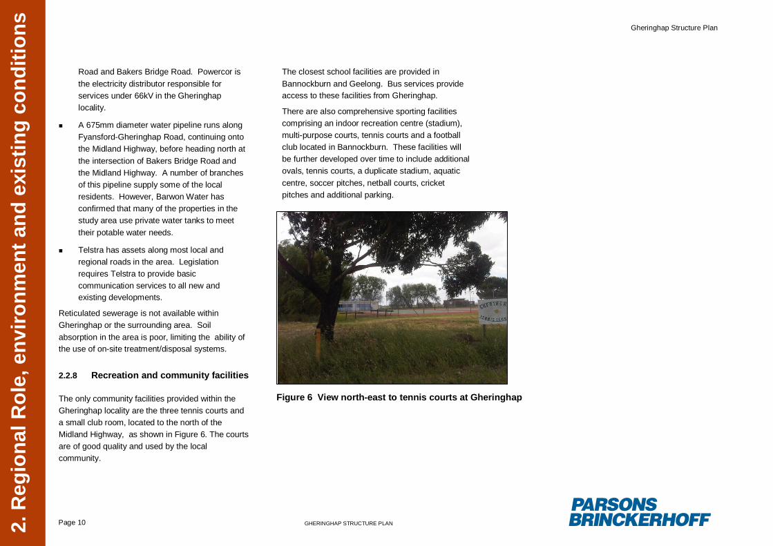
2.2.8 Recreation and community facilities
The only community facilities provided within theGheringhap locality are the three tennis courts anda small club room, located to the north of theMidland Highway, as shown in Figure 6. The courtsare of good quality and used by the localcommunity.
The closest school facilities are provided inBannockburn and Geelong. Bus services provideaccess to these facilities from Gheringhap.
There are also comprehensive sporting facilitiescomprising an indoor recreation centre (stadium),multi-purpose courts, tennis courts and a footballclub located in Bannockburn. These facilities willbe further developed over time to include additionalovals, tennis courts, a duplicate stadium, aquaticcentre, soccer pitches, netball courts, cricketpitches and additional parking.
Figure 6 View north-east to tennis courts at Gheringhap
Gheringhap Structure Plan
Page 11 GHERINGHAP STRUCTURE PLAN
3 Po
licy
Con
text
3. Policy context
3.1 Strategic direction
The State Planning Policy Framework (SPPF) andthe Local Planning Policy Framework (LPPF) setthe direction for future growth and development ofthe south-east region.
Analysis of the environmental, housing, economic,and rural development objectives under the SPPFand the LPPF has identified key themes relevant tothe type, form and spatial objectives for the GoldenPlains Shire as a whole and also to Gheringhapspecifically. These objectives are identified below,with discussion provided in Section 3.2 as to howthese relate to Gheringhap.
Settlement
Developing networks of settlements that willsupport resilient communities and the ability toadapt and change (Clause 11.05-1 SPPF).
To manage land use change and developmentin rural areas to promote agricultural and ruralproduction (Clause 11.05-3 SPPF).
Limit new housing development in rural areas,including:
Directing housing growth into existingsettlements
Discouraging development of isolatedsmall lots in the rural zones from use for
single dwellings, rural living or otherincompatible uses
Encouraging consolidation of existingisolated small lots in rural zones (Clause11.05-3).
Preserving and protecting features of ruralland and natural resources and features toenhance their contribution to settlements andlandscapes (Clause 11.05-1 SPPF).
The objectives and strategies relating to settlementunder the SPPF seek to manage future growth andprotect valuable agricultural land by directinghousing developments into existing urbansettlements. In regard to Gheringhap, this hasbeen demonstrated by the decisions of the GoldenPlains Shire to direct new residential growth intoBannockburn and Batesford.
The objectives also seek to ensure that the featuresof rural land and resources are protected and theircontribution to the settlement and landscape isenhanced. Again within the investigation area ofGheringhap the current settlement pattern hasresulted in a dispersed and less productive use ofagricultural land. The potential to consolidatesmaller holdings to improve the efficiency ofagricultural use is not feasible, given the value ofthese sites and the investment in housing andoutbuildings.
Economic Development
Provide adequate separation and buffer areasbetween sensitive uses and offensive ordangerous industries and quarries to ensure
that residents are not affected by adverseenvironmental effects, nuisance or exposureto hazards (Clause 17.02-2 SPPF).
The economic development objective under Clause17.02-2 seeks to ensure that appropriate separationdistances are maintained to avoid adverse impactson sensitive land uses. This is to allow theseenterprises to operate effectively and to provide aclear path for the augmentation of their plant whenrequired. It is also to provide certainty for theresidents who live immediately outside the requiredbuffer area, in making long term site investmentdecisions.
Infrastructure
To plan for the provision of water supply,sewerage and drainage services thatefficiently and effectively meet State andcommunity needs and protect the environment(Clause 19.03-2).
Clause 19.03-2 seeks to ensure that water,sewerage and drainage facilities are provided toadequately meet community needs. This is highlypertinent to the delivery of fully serviced land withinGheringhap, and the current absence of areticulated sewerage service.
South-East Area
Plan for staged business development in theGheringhap locality to take advantage of thelocalities proximity to infrastructure, whichincludes State highways, railways, highpressure gas pipeline, high voltage
Gheringhap Structure Plan
Page 12 GHERINGHAP STRUCTURE PLAN
3 Po
licy
Con
text
transmission line and water pipelines (Clause21.08 MSS, Strategy under Objective 1)
One of the key considerations here is the capabilityto effectively access these services. This isbecause they are main infrastructure services, andthere are substantial costs in providing for localreticulation.
Recognise environmental constraints andprotect environmental values and culturalheritage places (Clause 21.08 MSS, Objective2).
Maintain a clear distinction between urban andrural areas, maintaining the ‘non-urban’ breakbetween Batesford and Bannockburn (Clause21.08 MSS, Strategy under Objective 4).
This is also a clear strategic objective of theReview. The separation between Bannockburn andGheringhap is to be achieved by a non-urban breakadjacent to the Midland Highway, and betweenBatesford and Gheringhap by establishing a non-urban area along the western edge of Batesford.This Clause has been respected in this StructurePlan.
In the Gheringhap Precinct ensuredevelopment planning and the siting, designand operation of business uses with potentialfor adverse amenity impacts incorporaterelevant measures that minimise amenityimpacts on existing rural residential areas inthe locality (Clause 21.08 MSS, Strategyunder Objective 5)
The objectives for the south-east region under theMunicipal Strategic Statement (MSS) identify thestrategic opportunities within Gheringhap given itsproximity to infrastructure. The objectives seek totake advantages of the opportunities by planning forstaged business development in Gheringhap, whileminimising the adverse impacts on existing ruralresidential land uses.
There is a need to address the anticipatedfluctuations in the demand for employment land inthis location. Effective staging of the industrial landdelivery, that is within an area which does notcompromise the amenity of the adjacent ruralproperties will allow for the incrementaldevelopment of individual sites.
The objective also recognises the environmentalconstraints of the area and seeks to protectenvironmental and heritage values.
Intensive Animal Husbandry
To ensure the use and development of landfor intensive animal husbandry does notimpact on the environment (Clause 22.03LPPF).
To protect and maintain residential amenity inResidential Zones through the use of bufferareas and setbacks (Clause 22.03 LPPF).
The objectives of Clause 22.03 under the LPPFidentify the need to protect the amenity of existingresidential land uses from the potential impacts ofanimal husbandry activities. This includes the useof buffers and setbacks as necessary.
Floodplain management
To minimise flood risk and promotesustainable use and development of thefloodplain (Clause 22.11-1 LPPF).
Clause 22.11 seeks to minimise flood risks whilepromoting the sustainable use of floodplains. Thisis highly relevant in the Gheringhap locality due tothe potential impact of inundation from theMoorabool River to the north and in associationwith the previously identified significant wetlandimmediately south of the Midland Highway.
3.2 Directions for Gheringhap
The objectives and policies for the Golden PlainsShire and the south-east region seek to protectexisting agricultural activities while managing landuse change and providing for future growth anddevelopment of the region. Clause 11.05-3 of theSPPF in particular seeks to “manage land usechange and development in rural areas to promoteagricultural and rural production”. This emphasisesthe need to protect the existing poultry farms in thesouthern area of Gheringhap, around McCurdysand Booleys Road, ensuring that conflicts betweensensitive land uses are managed appropriately.
The south-east region, including Gheringhap,provides strategic opportunities with potential forfuture development of business, employment,industrial or transport activities. The location of theShire in proximity to Melbourne, Geelong andBallarat makes it attractive to export and transportfacilities, regional markets and export suppliers. It
Gheringhap Structure Plan
Page 13 GHERINGHAP STRUCTURE PLAN
3 Po
licy
Con
text
is important to recognise that development withinthe Gheringhap locality will be highly dependent onthe level of growth within Geelong and the adjacenttownships of Bannockburn and Batesford.
Gheringhap in particular, given its strategic positionwith the convergence of the Midland Highway,Fyansford-Gheringhap Road, the high pressure gaspipeline, and high voltage transmission line andwater pipelines, is suitable for land uses whichneed to be served by major road and/or rail andrequire electricity and/or gas services for operation.In addition, the large, vacant and flat parcels of landmake the area appropriate for land uses whichrequire large areas of land and/or require largebuffers.
Clause 21.08 of the MSS notes the importance ofplanning for future growth of Gheringhap, statingthe need to:
“Plan for staged business development in theGheringhap locality to take advantage of thelocalities proximity to infrastructure, whichincludes State highways, railways, highpressure gas pipeline, high voltagetransmission line and water pipelines”
Recognising the scale of these infrastructure itemsand the cost to develop local reticulation networks,there will be a need to harvest the necessary levieson development to finance access to these utilityservices.
In terms of residential and rural-residentialdevelopment, the Golden Plains Shire comprises asmall number of moderate sized towns (ie,
Bannockburn, Batesford, Lethbridge, Meredith) andlarge number of dispersed rural settlements, suchas Gheringhap. The SPPF and the MSS both seekto direct further housing growth into existingsettlements, discouraging the development ofisolated small lots. Both Bannockburn andBatesford are identified as areas where futureresidential and rural-residential growth is to occuras noted in the MSS, the Bannockburn UrbanDesign Framework and the Batesford FrameworkPlan. As such, any future rural-residentialdevelopment planned for the Gheringhap localityshould be limited, allowing this type of developmentto be directed to existing urban settlements, in linewith Council’s strategy for the region as a whole.
It is noted that, given the current settlement patternwithin Gheringhap there is an availability of ruralliving size allotments, and these allotments areanticipated to be retained in the immediate future.
State and local policies also recognises theimportance of maintaining a clear distinctionbetween the urban and rural areas, including areasbetween Batesford and Bannockburn. This is notedin Clause 21.08 of the MSS which seeks to:
“Maintain a clear distinction between urbanand rural areas, maintaining the ‘non-urban’break between Batesford and Bannockburn”
It is important to ensure that each settlement (i.e.Batesford, Gheringhap and Bannockburn) has itsown ‘identity’ and is spatially ‘separated’ from othersettlements. By retaining the previously identified‘rural breaks’ between the townships, it will avoidthe development of a continuous ‘line’ of
development surrounding the Midland Highway,which would ultimately lead to a lack of distinctionbetween each settlement. This is also important interms of the overall definition and character of thetownship. Gheringhap has a recognised andindependent community and the Structure Planseeks to retain this identity.
It is also important to identify and establish buffersto ensure that existing land uses and activities arenot adversely affected by future development. Thisis emphasised in Clause 17.02-2 of the SPPFwhich states the need to:
“Provide adequate separation and bufferareas between sensitive uses and offensive ordangerous industries and quarries to ensurethat residents are not affected by adverseenvironmental effects”
While it is noted that there are a number ofdevelopment opportunities within the Gheringhaplocality, there is potential for adverse impacts onexisting land uses if these activities are notappropriately sited. In particular,industrial/commercial development located tooclose to existing allotments utilised for residentialuse could have adverse impacts in terms of noiseand visual amenity issues. This Structure Planneeds to provide appropriate separation distancesbetween different land uses and provide designconsiderations (i.e. acoustic screening/landscapetreatment) that can minimise potential effects.
Equally important is the need to recognise existingnatural features and cultural heritage and to protectthese values and enhance their contribution to
Gheringhap Structure Plan
Page 14 GHERINGHAP STRUCTURE PLAN
3 Po
licy
Con
text
settlements and landscapes. The environmentaland heritage values of the locality as identified inSection 2.2, will need to be protected via relevantdevelopment controls and restrictions.
It is noted that there are opportunities to enhancethe appreciation of existing environmental featuresidentified within and surrounding the Gheringhaplocality by creating ‘ecological corridors’ which linkto other ecological areas. These corridors can formimportant view shafts or can be used by the localcommunity for recreational purposes (i.e. walkingtracks).
In planning for future growth and development aflexible approach is required, one which allowsGheringhap to respond to emerging trends anddevelopment opportunities as and when they arise.This is stated in the SPPF which seeks to develop:
“networks of settlements that will supportresilient communities and the ability to adaptand change” (Clause 11.05-1 SPPF).
The Structure Plan has been prepared on thisbasis, with the vision statement and principlesdeveloped for the locality (as outlined in Section 6),which are flexible enough to provide for futurechanges in demand and site characteristics.
In determining a vision for Gheringhap this hasbeen acknowledged in the form of the optionsprepared responding to the need for flexibility inboth the composition and rate of futuredevelopment. It is extremely important that theexisting settlement of Gheringhap achieves tangiblebenefits from this future development. This can be
achieved through the application of developmentlevies which are used to complete road accessimprovements, public environment areaenhancement and upgraded utility services.
Notwithstanding the above, it is noted that while theSPPF and the LPPF do clearly identify the keyoutcomes sought at the state and regional level, thepolicy does lack any specific direction as to thetype, form and extent of development for theGheringhap locality. As a result this Structure Planhas largely been based on a review of backgrounddocuments, site investigations and feedbackprovided from the community and stakeholders toprovide overall direction for the area, as furtherdiscussed in the following sections.
Gheringhap Structure Plan
Page 15 GHERINGHAP STRUCTURE PLAN
4 C
omm
unity
and
sta
keho
lder
eng
agem
ent
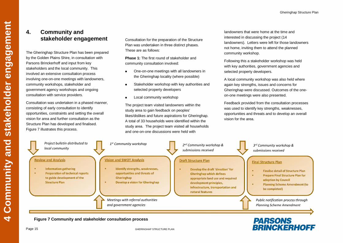
4. Community andstakeholder engagement
The Gheringhap Structure Plan has been preparedby the Golden Plains Shire, in consultation withParsons Brinckerhoff and input from keystakeholders and the local community. Thisinvolved an extensive consultation processinvolving one-on-one meetings with landowners,community workshops, stakeholder andgovernment agency workshops and ongoingconsultation with service providers.
Consultation was undertaken in a phased manner,consisting of early consultation to identifyopportunities, constraints and setting the overallvision for area and further consultation as theStructure Plan has developed and finalised.Figure 7 illustrates this process.
Consultation for the preparation of the StructurePlan was undertaken in three distinct phases.These are as follows:
Phase 1: The first round of stakeholder andcommunity consultation involved:
One-on-one meetings with all landowners inthe Gheringhap locality (where possible)
Stakeholder workshop with key authorities andselected property developers
Local community workshop
The project team visited landowners within thestudy area to gain feedback on peoples’likes/dislikes and future aspirations for Gheringhap.A total of 33 households were identified within thestudy area. The project team visited all householdsand one-on-one discussions were held with
landowners that were home at the time andinterested in discussing the project (14landowners). Letters were left for those landownersnot home, inviting them to attend the plannedcommunity workshop.
Following this a stakeholder workshop was heldwith key authorities, government agencies andselected property developers.
A local community workshop was also held whereagain key strengths, issues and concerns forGheringhap were discussed. Outcomes of the one-on-one meetings were also presented.
Feedback provided from the consultation processeswas used to identify key strengths, weaknesses,opportunities and threats and to develop an overallvision for the area.
Figure 7 Community and stakeholder consultation process
Gheringhap Structure Plan
Page 16 GHERINGHAP STRUCTURE PLAN
4 C
omm
unity
and
sta
keho
lder
eng
agem
ent
Phase 2: A draft Structure Plan was prepared andpresented at a second community meeting.Feedback from the community was recorded at thetime and subsequent submissions were received.
These submissions were used as a basis forupdating the Structure Plan.
Phase 3: Due to the nature of the submissions andthe resultant changes to the Structure Plan, Councilorganised a third community meeting to present theupdated version to the community. Feedbackreceived at this meeting was used to develop thefinal version of the Gheringhap Structure Plan.
The key themes and feedback received from thecommunity and stakeholder engagement processesare discussed below.
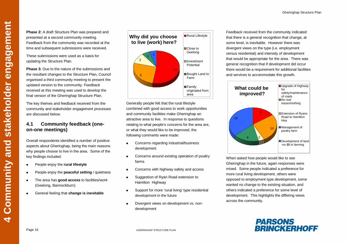
4.1 Community feedback (one-on-one meetings)
Overall respondents identified a number of positiveaspects about Gheringhap, being the main reasonswhy people choose to live in the area. Some of thekey findings included:
People enjoy the rural lifestyle
People enjoy the peaceful setting / quietness
The area has good access to facilities/work(Geelong, Bannockburn)
General feeling that change is inevitable
10
5
21 1
Why did you chooseto live (work) here?
Rural Lifestyle
Close toGeelong
InvestmentPotential
Bought Land toFarm
Familyoriginated fromarea
Generally people felt that the rural lifestylecombined with good access to work opportunitiesand community facilities make Gheringhap anattractive area to live. In response to questionsrelating to what people’s concerns for the area are,or what they would like to be improved, thefollowing comments were made:
Concerns regarding industrial/businessdevelopment
Concerns around existing operation of poultryfarms
Concerns with highway safety and access
Suggestion of Ryan Road extension toHamilton Highway
Support for more ‘rural living’ type residentialdevelopment in the future
Divergent views on development vs. non-development
Feedback received from the community indicatedthat there is a general recognition that change, atsome level, is inevitable. However there wasdivergent views on the type (i.e. employmentversus residential) and intensity of developmentthat would be appropriate for the area. There wasgeneral recognition that if development did occurthere would be a requirement for additional facilitiesand services to accommodate this growth.
8
14
29
19
What could beimproved?
Upgrade of Highwayforsafety/maintenanceof roadsNo realissues/nothing
Extension of RyansRoad to HamiltonHwy
Management ofpoultry farm
Development of land-no $$ in farming
When asked how people would like to seeGheringhap in the future, again responses weremixed. Some people indicated a preference formore rural living development, others wereopposed to employment type development, somewanted no change to the existing situation, andothers indicated a preference for some level ofdevelopment. This highlights the differing viewsacross the community.
Gheringhap Structure Plan
Page 17 GHERINGHAP STRUCTURE PLAN
4 C
omm
unity
and
sta
keho
lder
eng
agem
ent
4.2 Stakeholder feedback
A workshop was held with key stakeholders,including relevant Government agencies, and localland developers to identify the capacity of existinginfrastructure and to identify key opportunities andconstraints for the area. The findings from thisworkshop are summarised below:
VicRoads recognise safety issues on theMidland Highway
VicRoads confirmed that duplication of theMidland Highway is a long term strategicoption, but nothing is yet confirmed. Setbackrequirements will need to be consideredaround this Highway to provide for futurewidening if required
Barwon Water stated that there would belimited capacity for future development andthat upgrades would be required to thereticulated water supply. This could potentiallybe provided through provision of a pumpingstation or upgrade of the pumping stationsupplying Bannockburn and associated pipes
Barwon Water confirmed that there is nocapacity for reticulated sewerage and unlikelyto be in the future
Powercor identified two main power feeders toGheringhap; one along Midland Highway; andthe other along Hamilton Highway. Thefeeder is proposed to provide additionalcapacity to Bannockburn. There is potentialfor future capacity to Gheringhap through this
upgrade, with another proposed forBannockburn
Potential gas connection to Bannockburn inthe short-term future
Various development proposals werediscussed for the area (including a funeralchapel, an intermodal freight transfer facility, alocal store and a service station)
The Department of Planning and CommunityDevelopment (DPCD) highlighted the need for theStructure Plan to be consistent with the regionalgrowth plan currently being development for thearea. There is also a requirement to consider thebroader regional context, particularly in relation tothe demand and supply of industrial/employmentland. There may be an opportunity for Gheringhapto address capacity issues in relation to these landuses in Golden Plains Shire that cannot beprovided in surrounding towns such asBannockburn or Batesford (i.e. Bannockburn doesnot have the land capacity to provide for large scaledevelopments).
The need to confirm the capability of establishing arail intermodal facility at Gheringhap, which hasbeen suggested previously for this location,required that detailed discussions be completedwith representatives from Vic Track and theDepartment of Transport. As these two agencieswere not represented at the stakeholder workshop,separate meetings were held to discussdevelopment potential.
As a result of these discussions it was confirmedthat at this time there is no capability or justificationfor the establishment of a rail intermodal facility atGheringhap. This is because of the following:
It would jeopardise the existing and futureplanned operational capacity of the railwaylines
When considering the existing landscape andinfrastructure requirements, it would be anexpensive option to develop in the Gheringhaplocality. This includes the Midland Highwaybridge requiring significant works to allowadditional line capacity
There are a number of other complex issuesthat would need to be resolved includingdesign, interface, operational and compatibilityissues
4.3 Submissions
A total of 16 submissions were received on the draftStructure Plan. Themes included:
General acceptance of some development inGheringhap
Concern that development boundariesbisected property boundaries
Development should be contained either northor south of the Midland Highway
Specific property owners had no desire todevelop their property and wanted to retain asviable agriculture land
Gheringhap Structure Plan
Page 18 GHERINGHAP STRUCTURE PLAN
4 C
omm
unity
and
sta
keho
lder
eng
agem
ent
Land to the north of the Midland Highway isperceived to have better drainage than land tothe south. However development to the northraised concerns of potential contamination ofthe Moorabool River
Following consideration of the initial submissions,the draft Structure Plan was revised and re-exhibited with the community. A further sixsubmissions were received. Themes included:
Support for the amended draft Structure Plan
Desire to have their land included within theemployment precinct boundary
Preference for development to be directednorth of the Midland Highway
Opinion that development would significantlyimpact the existing amenity and quality of life
Preference to develop land designated withinthe non-urban break or rural area on theFramework Plan
Opinion that development would exacerbateflooding in flat low lying area’s and should bedirected to better drainage sites north of theMidland Highway.
Opinion that there should be a significantsetback of development from the McCurdyRoad boundary
Gheringhap Structure Plan
Page 19 GHERINGHAP STRUCTURE PLAN
5 Vi
sion
for G
herin
ghap
5. Vision for Gheringhap
5.1 Strengths, Weaknesses,Opportunities and Threats
The Gheringhap locality is recognised as having anumber of key attributes that make it attractive toresidents and being the main reasons why peoplechoose to live in the area. Residents havehighlighted the importance of the peaceful, rurallifestyle, with a number of the community expressingan interest in maintaining this character.
The area does however also contain a number ofconstraints which limit the development potentialand which need to be considered in the overallplanning for the area.
Prior to establishing the overall vision for the area,an analysis of the strengths, weaknesses,opportunities and threats was undertaken to assistin identifying key directions and constraints for thearea. The process for undertaking this analysis
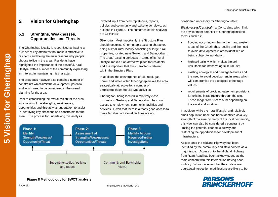
involved input from desk top studies, reports,policies and community and stakeholder views, asoutlined in Figure 8. The outcomes of this analysisare as follows:
Strengths: Most importantly, the Structure Planshould recognise Gheringhap’s existing character,being a small rural locality consisting of large ruralproperties, located near Geelong and Bannockburn.The areas’ existing attributes in terms of its ‘rurallifestyle’ makes it an attractive place for residentsand it is important that this character is retainedwithin the Structure Plan.
In addition, the convergence of rail, road, gas,power and water within Gheringhap makes the areastrategically attractive for a number ofemployment/commercial type activities.
Gheringhap, being located in relatively closeproximity to Geelong and Bannockburn has goodaccess to employment, community facilities andservices. Given that there is already good access tothese facilities, additional facilities are not
considered necessary for Gheringhap itself.
Weaknesses/Constraints: Constraints which limitthe development potential of Gheringhap includefactors such as:
flooding occurring on the northern and westernareas of the Gheringhap locality and the needto avoid development in areas identified asbeing subject to inundation;
high soil salinity which makes the soilunsuitable for intensive agricultural use;
existing ecological and heritage features andthe need to avoid development in areas whichwill compromise the ecological or heritagevalues;
requirements of providing easement provisionsfor existing infrastructure through the site.These range from 15m to 50m depending onthe asset and location.
In addition, while the ‘rural-lifestyle’ and relativelysmall population base has been identified as a keystrength of the area by many of the local community,this view can also be considered a constraint bylimiting the potential economic activity andrestricting the opportunities for development ofinfrastructure.
Access onto the Midland Highway has beenidentified by the community and stakeholders as amajor issue. Access onto the Midland Highwayfrom Ryan Road has been acknowledged as themain concern with this intersection having poorvisibility. While it is noted that the costs of roadupgrades/intersection modifications are likely to be
Figure 8 Methodology for SWOT analysis
Gheringhap Structure Plan
Page 20 GHERINGHAP STRUCTURE PLAN
5 Vi
sion
for G
herin
ghap
significant, VicRoads recognises that this issueneed to be addressed.
Opportunities: There are a number of key land useopportunities for Gheringhap. It is recognised that ifappropriately located, these land uses could havebenefits for existing residents and can assist inmeeting regional demands. Most notably, the large,vacant and flat parcels of land make the areasuitable for land uses which require large areas ofland/and or require large buffers. Industrialdevelopment/commercial activities would improvethe economic base and would also createemployment opportunities. Such developmentwould be consistent with the policy direction for theGheringhap locality as identified under the MSS,with Clause 21.08 seeking to “plan for stagebusiness development” within Gheringhap. Areas ofland suitable for this type of development should beidentified, taking into account locational constraints,appropriate buffers and separation distances fromexisting residential development.
Some landowners during the consultation processexpressed an interest in subdividing properties foradditional ‘rural-living’ style development. However,the roads and infrastructure (water, electricity andgas) required to support large numbers of rural-living developments could not be adequatelyprovided by Council or service providers as thecosts could not be sufficiently recovered throughrates or the cost of the development. In addition,such development would be inconsistent with thepolicy direction for the south-east Region, which, asdiscussed in Section 3, seeks to direct additionalrural-living development into the existing settlementsof Batesford and Bannockburn. Some small scale
rural-living development may however be suitable incertain locations, taking into account the ability ofexisting services and infrastructure to accommodatethis growth.
Various ‘small scale’ development proposals havebeen identified by stakeholders for the Gheringhaplocality. For example a funeral chapel, local storeand service station have been discussed aspossible activities to be located within Gheringhap.Given that such uses would serve a ‘local’ functionand can be relatively easily accommodated withinthe existing setting without requiring anyinfrastructure upgrades, such developments areconsidered suitable. If appropriately located theseactivities could assist in developing a ‘centre’ for theGheringhap locality and ‘focal point’ for the area.There is a need to identify parcels of land that wouldbe suitable for this type of development and ensurethat appropriate separation distances are providedfrom these land uses and other incompatible landuses.
It is noted that a previous study undertaken in 2011by Rehbein Airport Consulting recommendedsafeguarding land within Gheringhap for a possiblefuture regional Airport. The report identified apreferred site at Lethbridge for a new Airport, butalso stated that Council should consider securingland within Gheringhap, at the time of preparing theStructure Plan. Golden Plains Shire has confirmedsupport for the airport at Lethbridge, but has alsonoted that there is sufficient land to the south of thearea included within the Gheringhap Structure Planwhich could accommodate a regional Airport, ifrequired in the future.
Threats: There is potential for adverse impacts onexisting land uses as a result of future developmentwithin Gheringhap. In particular,industrial/commercial development located too closeto existing residential land-use could have adverseimpacts in terms of noise and visual amenity issues.This Structure Plan needs to consider appropriateseparation distances between different land uses(i.e. residential and industrial activities) and designconsiderations (i.e. landscaping/screening) that canminimise potential effects.
There is potential for reverse sensitivity effects onexisting activities, such as the poultry farms and therail corridor. There is a need to maintain bufferrequirements around the poultry farms(recommended 500m between sensitive land usesand poultry farms as noted in the Poultry FarmingPlanning Guide) and to introduce appropriatesetback requirements from the rail corridor to avoidcurfews or operation restrictions on rail services inthe future.
Gheringhap Structure Plan
Page 21 GHERINGHAP STRUCTURE PLAN
5 Vi
sion
for G
herin
ghap
5.2 The Vision
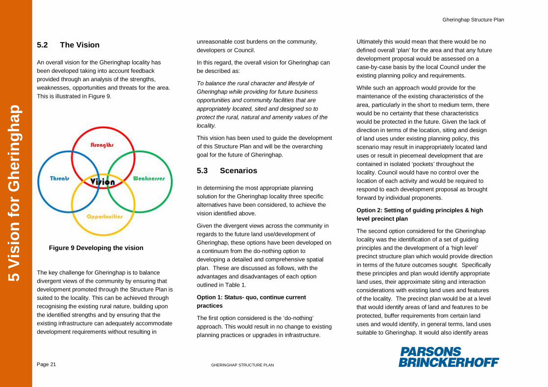
An overall vision for the Gheringhap locality hasbeen developed taking into account feedbackprovided through an analysis of the strengths,weaknesses, opportunities and threats for the area.This is illustrated in Figure 9.
The key challenge for Gheringhap is to balancedivergent views of the community by ensuring thatdevelopment promoted through the Structure Plan issuited to the locality. This can be achieved throughrecognising the existing rural nature, building uponthe identified strengths and by ensuring that theexisting infrastructure can adequately accommodatedevelopment requirements without resulting in
unreasonable cost burdens on the community,developers or Council.
In this regard, the overall vision for Gheringhap canbe described as:
To balance the rural character and lifestyle ofGheringhap while providing for future businessopportunities and community facilities that areappropriately located, sited and designed so toprotect the rural, natural and amenity values of thelocality.
This vision has been used to guide the developmentof this Structure Plan and will be the overarchinggoal for the future of Gheringhap.
5.3 Scenarios
In determining the most appropriate planningsolution for the Gheringhap locality three specificalternatives have been considered, to achieve thevision identified above.
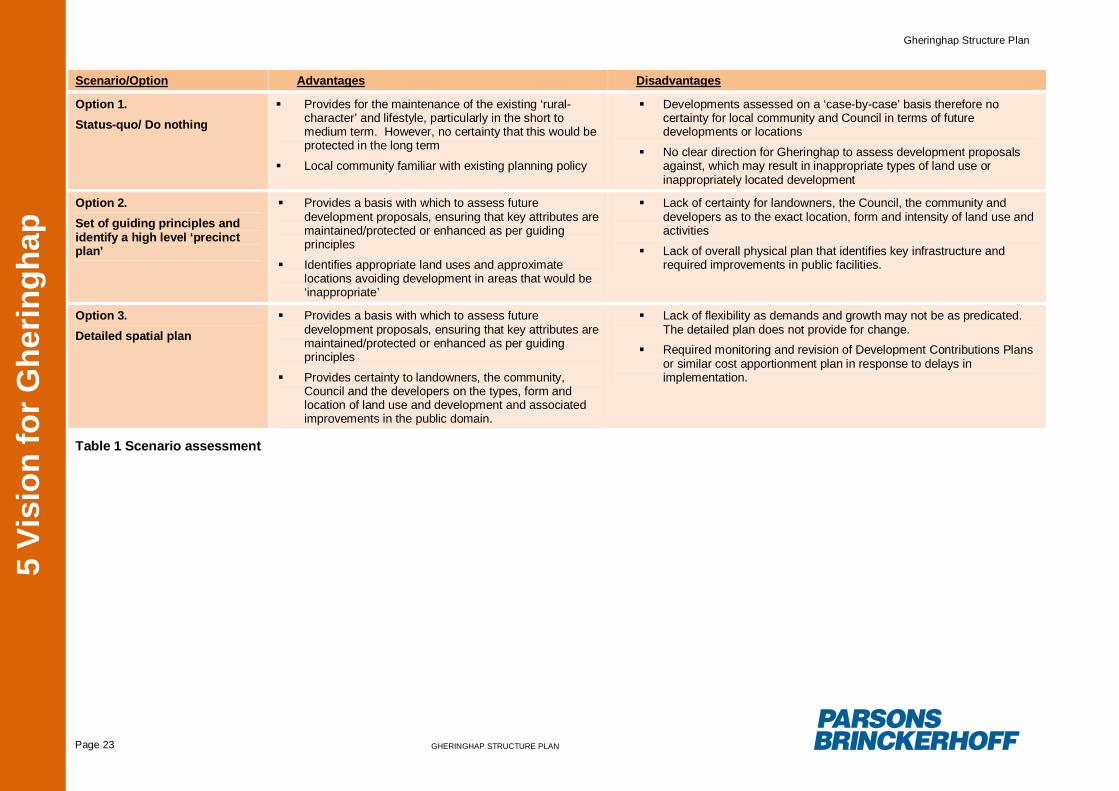
Given the divergent views across the community inregards to the future land use/development ofGheringhap, these options have been developed ona continuum from the do-nothing option todeveloping a detailed and comprehensive spatialplan. These are discussed as follows, with theadvantages and disadvantages of each optionoutlined in Table 1.
Option 1: Status- quo, continue currentpractices
The first option considered is the ‘do-nothing’approach. This would result in no change to existingplanning practices or upgrades in infrastructure.
Ultimately this would mean that there would be nodefined overall ‘plan’ for the area and that any futuredevelopment proposal would be assessed on acase-by-case basis by the local Council under theexisting planning policy and requirements.
While such an approach would provide for themaintenance of the existing characteristics of thearea, particularly in the short to medium term, therewould be no certainty that these characteristicswould be protected in the future. Given the lack ofdirection in terms of the location, siting and designof land uses under existing planning policy, thisscenario may result in inappropriately located landuses or result in piecemeal development that arecontained in isolated ‘pockets’ throughout thelocality. Council would have no control over thelocation of each activity and would be required torespond to each development proposal as broughtforward by individual proponents.
Option 2: Setting of guiding principles & highlevel precinct plan
The second option considered for the Gheringhaplocality was the identification of a set of guidingprinciples and the development of a ‘high level’precinct structure plan which would provide directionin terms of the future outcomes sought. Specificallythese principles and plan would identify appropriateland uses, their approximate siting and interactionconsiderations with existing land uses and featuresof the locality. The precinct plan would be at a levelthat would identify areas of land and features to beprotected, buffer requirements from certain landuses and would identify, in general terms, land usessuitable to Gheringhap. It would also identify areas
Figure 9 Developing the vision
Gheringhap Structure Plan
Page 22 GHERINGHAP STRUCTURE PLAN
5 Vi
sion
for G
herin
ghap
that would be appropriate for future development.The plan would not provide detail in terms of theprecise siting of each activity and size of lots, butrather would identify general areas for future landuses/development.
These guiding principles and precinct plan couldpotentially be incorporated into the Golden PlainsPlanning Scheme and would be used as a basis ofassessing development proposals provided byproponents.
In addition, such principles would also be used as abasis of directing Council’s infrastructureexpenditure and arrangements with stakeholders interms of upgrades/new facilities required for thelocality.
Such an approach would provide some level ofcertainty to landowners, the Council, the communityand developers as to the type and approximatelocation of future land uses and development.However, there would be no certainty as to theexact location, the form and intensity of land useactivities. Within this context it would also bedifficult for detailed cost apportionment in the form ofa Development Contributions Plan or similarinstruments.
Option 3: Detailed spatial plan
The third option considered for the Gheringhaplocality was the development of a detailed spatialplan based on the set of guiding principles asidentified in Option 2.
This spatial plan would be more detailed than thehigh level precinct plan as identified for Option 2 asit would control the type of development, identify the
precise location of each land use activity and controlthe intensity (i.e. number of lots and size ofdevelopment) of future land uses within Gheringhap.
This spatial plan could also be accompanied by aDevelopment Contributions Plan or similar costapportionment mechanism to identify whichimprovements in road access, public areas andutility services are to be provided, and how they areto be funded by future development.
While such an approach would provide benefits tolocal landowners, the Council and developers interms of providing absolute certainty as to wherecertain land uses can and will locate, this approachis somewhat flawed in that Council cannot controlthe rate and demand for such development.Demands and trends change over time andsettlements must be able to adapt and respond tothese changes so that they are resilient over time.A spatial plan that lacks any flexibility could lead to asituation where the demand for the land useactivities identified in the spatial plan changes or isnever realised, leading to large expanses ofdesignated land which are essentially ‘unusable’ foruses other than those identified in the plan.
A plan of this nature will require periodic reviewsand possible revisions to respond to fluctuations indemand, and changes in utility servicerequirements. Such a process would ultimatelyprovide a nexus for ‘ad-hoc’ planning as describedin Option 1.
5.3.1 Preferred Scenario
Based on the assessment of options identifiedabove, Option 2: Setting of guiding principles andhigh level precinct plan is considered to be the mostappropriate option to achieve the vision for theGheringhap locality. This is on the basis that thisscenario would provide the greatest flexibility forchange when responding to future demands, whilealso providing certainty to the local community andCouncil in terms of what type of development islikely to be encouraged and where this will belocated.
Accordingly this option has been taken forward forthe development of the Structure Plan forGheringhap.
Gheringhap Structure Plan
Page 23 GHERINGHAP STRUCTURE PLAN
5 Vi
sion
for G
herin
ghap
Table 1 Scenario assessment
Scenario/Option Advantages Disadvantages
Option 1.Status-quo/ Do nothing
Provides for the maintenance of the existing ‘rural-character’ and lifestyle, particularly in the short tomedium term. However, no certainty that this would beprotected in the long term
Local community familiar with existing planning policy
Developments assessed on a ‘case-by-case’ basis therefore nocertainty for local community and Council in terms of futuredevelopments or locations
No clear direction for Gheringhap to assess development proposalsagainst, which may result in inappropriate types of land use orinappropriately located development
Option 2.Set of guiding principles andidentify a high level ‘precinctplan’
Provides a basis with which to assess futuredevelopment proposals, ensuring that key attributes aremaintained/protected or enhanced as per guidingprinciples
Identifies appropriate land uses and approximatelocations avoiding development in areas that would be‘inappropriate’
Lack of certainty for landowners, the Council, the community anddevelopers as to the exact location, form and intensity of land use andactivities
Lack of overall physical plan that identifies key infrastructure andrequired improvements in public facilities.
Option 3.Detailed spatial plan
Provides a basis with which to assess futuredevelopment proposals, ensuring that key attributes aremaintained/protected or enhanced as per guidingprinciples
Provides certainty to landowners, the community,Council and the developers on the types, form andlocation of land use and development and associatedimprovements in the public domain.
Lack of flexibility as demands and growth may not be as predicated.The detailed plan does not provide for change.
Required monitoring and revision of Development Contributions Plansor similar cost apportionment plan in response to delays inimplementation.
Gheringhap Structure Plan
Page 24 GHERINGHAP STRUCTURE PLAN6 P
lann
ing
for G
herin
ghap
– s
trat
egic
resp
onse
6. Planning for Gheringhap– strategic response
6.1 Guiding principlesThe following set of principles have been developedwhich will serve as a basis for determining futureland use and for directing future investments ininfrastructure and services. These principles arebased on the overall vision and have beendeveloped based on the analysis of the strengths,weaknesses, opportunities and threats as outlined inSection 5. They are to be read in conjunction withFigure 10 – Gheringhap Land Use Framework Plan.
These principles outline the high level strategicobjectives for the Gheringhap locality and will beused by Council to inform future policy directionsand to assess development proposals in the area.
These are as follows:
1. Encourage a ‘planned’ approach todevelopment, avoiding ad hoc decisions
It is important that land use decisions are made in acomprehensive manner, ensuring that outcomes areconsistent with the overall objectives for the area.Failure to do so can lead to ad-hoc decisions, wherematters such as cumulative impacts are notadequately considered.
An integrated approach where there is an overallplan guiding land use decisions is likely to producemore desirable outcomes to manage the futuregrowth and development of the Gheringhap area. Itwould also promote growth in accordance with theLand Use Framework Plan.
This will also give greater assurance to residentswho occupy allotments within the Gheringhap
locality which lots will be affected by future changesin land use.
While it is noted that each development proposal willbe assessed on a case-by-case basis, theseprinciples will ensure that the outcomes areconsistent with an overall approach for the area.
It is important to emphasise that this plan is a ‘guide’rather than a strict spatial plan. Futuredevelopments should be assessed against this planbut a flexible approach should be taken.
It is the impacts of the activities on the characterand surrounding environment that are important –rather than conforming strictly with the planlocations. The plan identifies the preferreddistribution of land uses, modification to transportroutes and potential target sites for community andcommercial facilities. It also identifies requiredbuffers and ecological corridors/links. Some generaldirection for the ongoing enhancement ofGheringhap is included in the plan.
2. Limit development on parcels of land whichhave existing constraints/commitments
There are a number of constraints which limit thedevelopment potential of Gheringhap. These includefactors such as: existing settlement areas, flooding,utility service corridors, ecological and heritagevalues, urban break /buffers, and poultry farmingbuffers. These are identified in Figure 11 –Gheringhap Constraints/Commitment Plan andultimately define the Gheringhap Structure PlanArea. Importantly, some of these potentialconstraints could be considered attributes for thedevelopment of the township. For example therequirement for inter-urban breaks will allow forcomprehensive landscape treatment of the roadcorridor between Gheringhap and Bannockburn toestablish a stronger landscape character setting for
the town. The areas which have been identified assubject to flooding south of the Midland Highwayhave the potential to be used for wetland habitats.This has been expressed as a key aspiration forsome of the community within Gheringhap.
3. Protect existing assets and infrastructure.Maximise the opportunities that theseservices provide for businesses, thecommunity and the region as a whole
Within the central area of Gheringhap andimmediately adjacent to the road and rail corridors,land parcels are generally on flat land and are notsubject to inundation .These areas are howeverbound by rural living style allotments to the south,and require an effective treatment of the rearboundaries of the properties on the north side ofMcCurdy Road. These properties have thecapability to provide an effective address point andgateway from the Midland Highway and theFyansford-Gheringhap Road.
The rail asset within the Structure Plan Area is alsoan area which requires significant consideration.Any use located on adjacent land which wouldjeopardise the optimum usage of this asset shouldbe discouraged. This includes noise sensitive landuses or uses which would affect the existing andfuture operational capacity of the train lines.
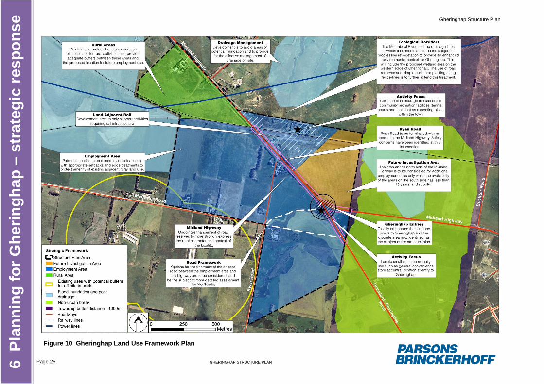
Gheringhap Structure Plan
Page 25 GHERINGHAP STRUCTURE PLAN6 P
lann
ing
for G
herin
ghap
– s
trat
egic
resp
onse
Figure 10 Gheringhap Land Use Framework Plan
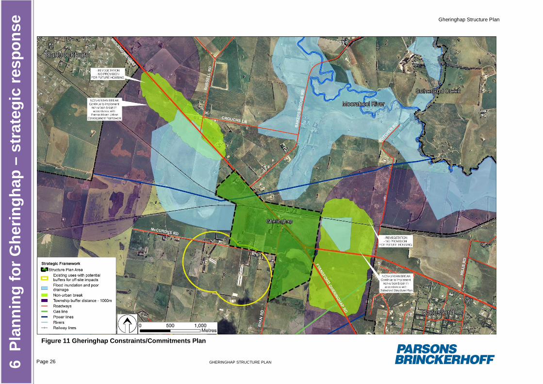
Gheringhap Structure Plan
Page 26 GHERINGHAP STRUCTURE PLAN6 P
lann
ing
for G
herin
ghap
– s
trat
egic
resp
onse
Figure 11 Gheringhap Constraints/Commitments Plan
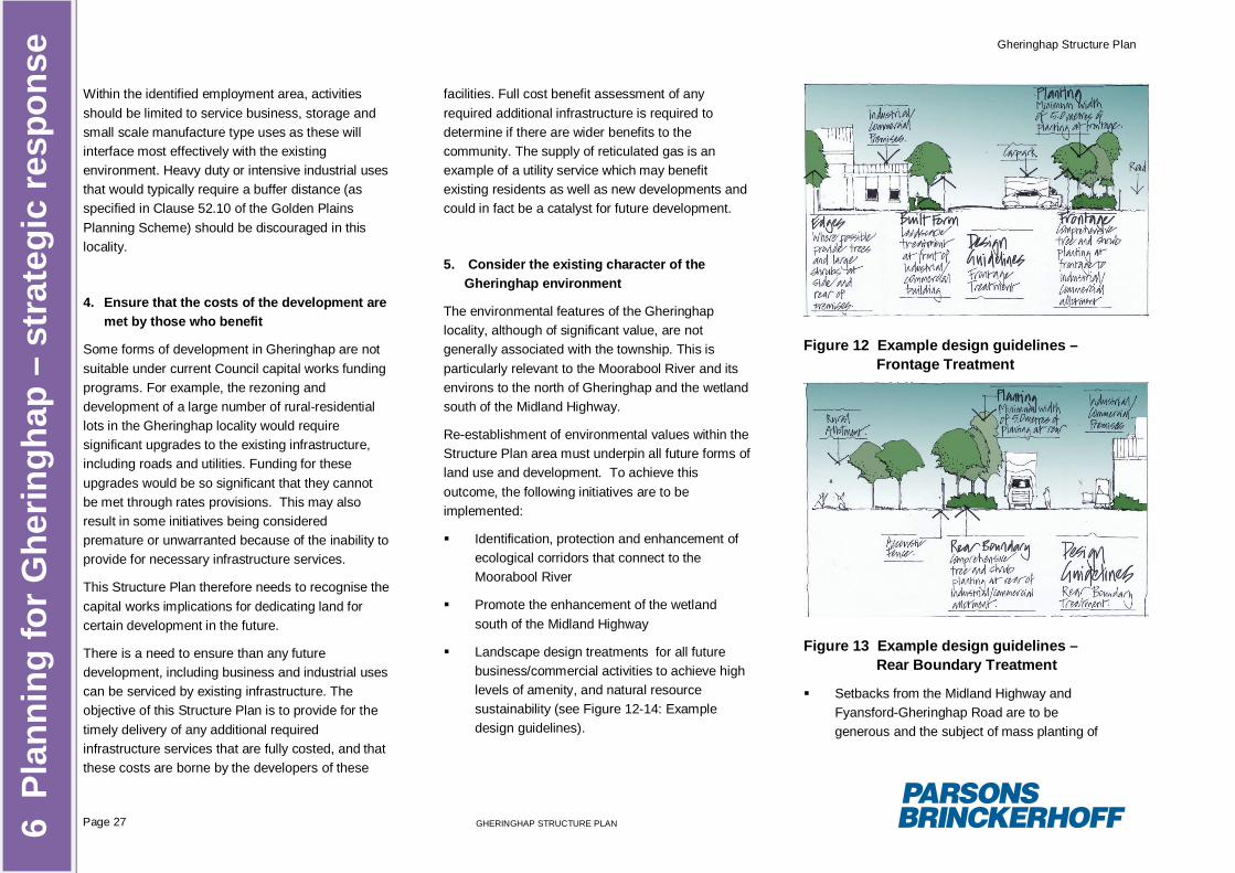
Gheringhap Structure Plan
Page 27 GHERINGHAP STRUCTURE PLAN6 P
lann
ing
for G
herin
ghap
– s
trat
egic
resp
onse
Within the identified employment area, activitiesshould be limited to service business, storage andsmall scale manufacture type uses as these willinterface most effectively with the existingenvironment. Heavy duty or intensive industrial usesthat would typically require a buffer distance (asspecified in Clause 52.10 of the Golden PlainsPlanning Scheme) should be discouraged in thislocality.
4. Ensure that the costs of the development aremet by those who benefit
Some forms of development in Gheringhap are notsuitable under current Council capital works fundingprograms. For example, the rezoning anddevelopment of a large number of rural-residentiallots in the Gheringhap locality would requiresignificant upgrades to the existing infrastructure,including roads and utilities. Funding for theseupgrades would be so significant that they cannotbe met through rates provisions. This may alsoresult in some initiatives being consideredpremature or unwarranted because of the inability toprovide for necessary infrastructure services.
This Structure Plan therefore needs to recognise thecapital works implications for dedicating land forcertain development in the future.
There is a need to ensure than any futuredevelopment, including business and industrial usescan be serviced by existing infrastructure. Theobjective of this Structure Plan is to provide for thetimely delivery of any additional requiredinfrastructure services that are fully costed, and thatthese costs are borne by the developers of these
facilities. Full cost benefit assessment of anyrequired additional infrastructure is required todetermine if there are wider benefits to thecommunity. The supply of reticulated gas is anexample of a utility service which may benefitexisting residents as well as new developments andcould in fact be a catalyst for future development.
5. Consider the existing character of theGheringhap environment
The environmental features of the Gheringhaplocality, although of significant value, are notgenerally associated with the township. This isparticularly relevant to the Moorabool River and itsenvirons to the north of Gheringhap and the wetlandsouth of the Midland Highway.
Re-establishment of environmental values within theStructure Plan area must underpin all future forms ofland use and development. To achieve thisoutcome, the following initiatives are to beimplemented:
Identification, protection and enhancement ofecological corridors that connect to theMoorabool River
Promote the enhancement of the wetlandsouth of the Midland Highway
Landscape design treatments for all futurebusiness/commercial activities to achieve highlevels of amenity, and natural resourcesustainability (see Figure 12-14: Exampledesign guidelines).
Figure 12 Example design guidelines –Frontage Treatment
Figure 13 Example design guidelines –Rear Boundary Treatment
Setbacks from the Midland Highway andFyansford-Gheringhap Road are to begenerous and the subject of mass planting of
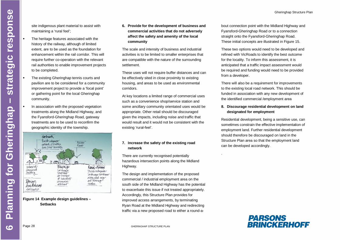
Gheringhap Structure Plan
Page 28 GHERINGHAP STRUCTURE PLAN6 P
lann
ing
for G
herin
ghap
– s
trat
egic
resp
onse
site indigenous plant material to assist withmaintaining a ‘rural feel’;
The heritage features associated with thehistory of the railway, although of limitedextent, are to be used as the foundation forenhancement within the rail corridor. This willrequire further co-operation with the relevantrail authorities to enable improvement projectsto be completed.
The existing Gheringhap tennis courts andpavilion are to be considered for a communityimprovement project to provide a ‘focal point’or gathering point for the local Gheringhapcommunity.
In association with the proposed vegetationtreatments along the Midland Highway, andthe Fyansford-Gheringhap Road, gatewaytreatments are to be used to reconfirm thegeographic identity of the township.
Figure 14 Example design guidelines –Setbacks
6. Provide for the development of business andcommercial activities that do not adverselyaffect the safety and amenity of the localcommunity
The scale and intensity of business and industrialactivities is to be limited to smaller enterprises thatare compatible with the nature of the surroundingsettlement.
These uses will not require buffer distances and canbe effectively sited in close proximity to existinghousing, and areas to be used as environmentalcorridors.
At key locations a limited range of commercial usessuch as a convenience shop/service station andsome ancillary community orientated uses would beappropriate. Other retail should be discouragedgiven the impacts, including noise and traffic thatwould result and it would not be consistent with theexisting ‘rural-feel’.
7. Increase the safety of the existing roadnetwork
There are currently recognised potentiallyhazardous intersection points along the MidlandHighway.
The design and implementation of the proposedcommercial / industrial employment area on thesouth side of the Midland Highway has the potentialto exacerbate this issue if not treated appropriately.Accordingly, this Structure Plan provides forimproved access arrangements, by terminatingRyan Road at the Midland Highway and redirectingtraffic via a new proposed road to either a round-a-
bout connection point with the Midland Highway andFyansford-Gheringhap Road or to a connectionstraight onto the Fyansford-Gheringhap Road.These initial concepts are illustrated in Figure 15.
These two options would need to be developed andrefined with VicRoads to identify the best outcomefor the locality. To inform this assessment, it isanticipated that a traffic impact assessment wouldbe required and funding would need to be providedfrom a developer.
There will also be a requirement for improvementsto the existing local road network. This should befunded in association with any new development ofthe identified commercial /employment area
8. Discourage residential development on landdesignated for employment
Residential development, being a sensitive use, cansometimes constrain the effective implementation ofemployment land. Further residential developmentshould therefore be discouraged on land in theStructure Plan area so that the employment landcan be developed accordingly.
.
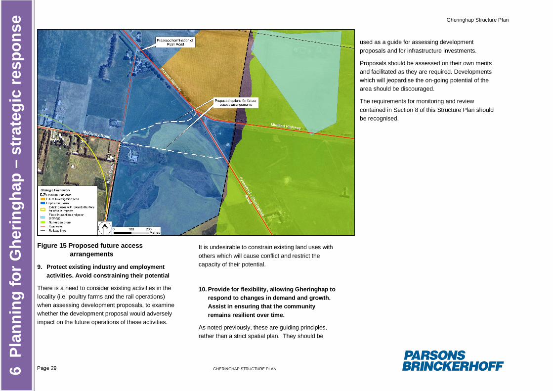
Gheringhap Structure Plan
Page 29 GHERINGHAP STRUCTURE PLAN6 P
lann
ing
for G
herin
ghap
– s
trat
egic
resp
onse
Figure 15 Proposed future accessarrangements
9. Protect existing industry and employmentactivities. Avoid constraining their potential
There is a need to consider existing activities in thelocality (i.e. poultry farms and the rail operations)when assessing development proposals, to examinewhether the development proposal would adverselyimpact on the future operations of these activities.
It is undesirable to constrain existing land uses withothers which will cause conflict and restrict thecapacity of their potential.
10. Provide for flexibility, allowing Gheringhap torespond to changes in demand and growth.Assist in ensuring that the communityremains resilient over time.
As noted previously, these are guiding principles,rather than a strict spatial plan. They should be
used as a guide for assessing developmentproposals and for infrastructure investments.
Proposals should be assessed on their own meritsand facilitated as they are required. Developmentswhich will jeopardise the on-going potential of thearea should be discouraged.
The requirements for monitoring and reviewcontained in Section 8 of this Structure Plan shouldbe recognised.
Gheringhap Structure Plan
Page 30 GHERINGHAP STRUCTURE PLAN
7 Im
plem
enta
tion
7. Implementation
The challenge Golden Plains Shire faces with futureurban growth means that it will be forced to makehard decisions about urban form and identifytargeted redevelopment of strategic areas. This isnormally completed in conjunction with new urbangrowth in greenfield areas. Gheringhap has beenidentified as being an area that can accommodateurban development in the future when recognisingthe residential development currently occurring inBannockburn and Batesford.
It is difficult to predict accurately the long termrequirements or potential growth of the Gheringhaplocality; however should the necessity arise for landto be ‘ready to go’ Council needs to be able toensure that development is indeed well located, hasservice capability and does not impact on theexisting community.
The identified commercial / employment area in thisStructure Plan has a land area of approximately125ha of generally vacant and unconstrained land.Through implementation of this Structure Plan,moderate growth can occur and is supported.Should further demand and therefore land berequired, the land north of the Midland Highway(20ha) can be investigated in the future. This willoccur at a designated ‘trigger point’ when theavailability of the land on the south side of theMidland Highway has less than 15 years landsupply.
Each of these areas have been identified aspossible for development. Decisions about each siteneed to be made in association with the landowners
to facilitate the development. Some portions of thesites may be ruled out for the foreseeable future.Decisions that effectively lock these sites into longterm fixed uses that perpetuate current inefficienciesin the urban form should be avoided.
Despite the opportunities presented in Gheringhap,the successful implementation of this Structure planrequires the cooperation and involvement of allparties including Council, stakeholders, serviceproviders, land developers and the local community.
7.1 Implementation Actions
This Structure Plan provides a framework fordevelopment in the Gheringhap locality over thenext 20+ years with identified policies and strategiesto provide a basis for future decision-making.
It should be noted that some initiatives reflected inthe Structure Plan are already in the process ofbeing implemented. This reflects existing Councilprograms and priorities and the integration withother townships including Batesford andBannockburn.
This Section identifies implementation provisionsand key Planning Scheme alterations, or supportingstrategic work, necessary to attain the principles anddirections identified in the Structure Plan including:
Introduction of Planning Policy:
Application of Zones and Overlays;
Further strategic work required to supportadditional planning controls;
Other actions critical to attaining key principlesand directions.
7.2 Planning scheme changes
The primary planning instrument or statutoryprocess to implement this Structure Plan is throughthe Golden Plains Planning Scheme. This willensure that the identified land is reserved andavailable to accommodate the identifieddevelopment requirements, as anticipate by thisStructure Plan, over the long term – the next twentyyears (refer to Implementation Table at Section 7.4).Four specific changes are recommended toimplement the Structure Plan:
The Gheringhap Structure Plan should bereferenced in the Municipal StrategicStatement (MSS) as the basis for the strategicplanning of Gheringhap
The MSS should set out that development inGheringhap should be guided by thedevelopment principles. This is a criticalimplementation element of the Plan. Thisstatement ensures that it outlines a clearexpectation in providing the desired outcomeof facilitating flexibility for change whenresponding to future demands. It also providescertainty to the local community and Council interms of what type of development is likely tobe encouraged and where this will be located.
The MSS would indicate that a principal meansof implementing the Structure Plan would be tosupport a progressive series of rezoning of theland in Gheringhap, in line with the stageddevelopment.
The MSS would reference a Local PlanningPolicy to be inserted in the Local Planning
Gheringhap Structure Plan
Page 31 GHERINGHAP STRUCTURE PLAN
7 Im
plem
enta
tion
Policy Framework. The Local Policy would setout the principles that are listed in theGheringhap Structure Plan and reference thedocument. The Policy would provide that alluse and development should be consistentwith the guiding principles of the Plan. ThePolicy would also state that all proposals forthe rezoning of land should be consistent withthese principles. The Policy should alsoprovide for amendments of the Structure PlanPrinciples and Plans following a consultativeprocess should the need arise.
7.3 Developer Contributions
For Gheringhap to progress as set out in thisStructure Plan, new development is required. Thereis an opportunity to seek developer contributions inthe form of payments or in-kind works for civicinfrastructure improvements. This may include roads(new roads, bicycle/pedestrian paths, intersectiontreatments), streetscapes (lighting, kerb andchannel), storm water and urban run-offmanagement systems, open space and otherfacilities.
There are principally two methods whereby Councilmay recoup costs from landowners to offset the costof development and associated infrastructureprovision:
Section 173 Agreements – Council may enterinto individual Section 173 Agreements insteadof using a Development Contributions Plan(DCP) to recoup the apportioned cost ofproviding infrastructure. The required upgrades
to services and infrastructure may benegotiated at the time of a rezoning requestand secured through a Section 173Agreement. Alternatively a Section 173Agreement could appear as a permit conditionhowever this would be open to challenge atVCAT.
DCP’s – A DCP is different to a mutuallyagreed Section 173. A DCP is binding to bothCouncil and landowners and monies must bespent by Council when and on what it wascollected for. It sets out a framework of whatprojects are required, the cost of each project,when it will be delivered, what is Council’scontribution and how much is apportioned tothe landowner. DCP’s are transparent,equitable and provide certainty.
Whilst a DCP is the preferred mechanism forsecuring contributions, this option is both costly andtimely. In addition Council would need a clearunderstanding of how the land is to be used anddeveloped to complete a DCP. The GheringhapStructure Plan identifies land for an ‘employmentprecinct’ however is not specific about how the landwill be used and does not propose to rezone land.Council therefore has an opportunity to considernecessary contributions, associated upgrades,service connections and costs at the time a rezoningapplication is made. There is also greateropportunity to enter into a Section 173 Agreementwith the landowner at the time of rezoning than atthe Planning Permit stage.
Council is wishing to pursue the development of aDCP for the entire municipality once the Minister for
Planning releases a standard model. At this timefurther consideration may be given to theGheringhap area.
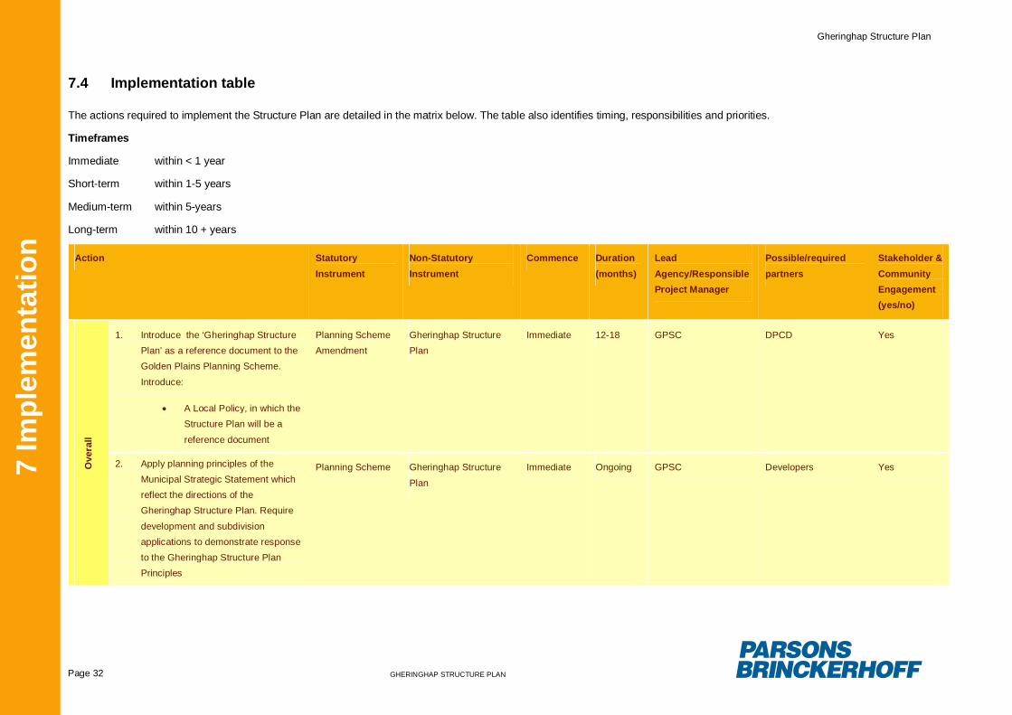
Gheringhap Structure Plan
Page 32 GHERINGHAP STRUCTURE PLAN
7 Im
plem
enta
tion
7.4 Implementation table
The actions required to implement the Structure Plan are detailed in the matrix below. The table also identifies timing, responsibilities and priorities.
Timeframes
Immediate within < 1 year
Short-term within 1-5 years
Medium-term within 5-years
Long-term within 10 + years
Action StatutoryInstrument
Non-StatutoryInstrument
Commence Duration(months)
LeadAgency/ResponsibleProject Manager
Possible/requiredpartners
Stakeholder &CommunityEngagement(yes/no)
Ove
rall
1. Introduce the ‘Gheringhap StructurePlan’ as a reference document to theGolden Plains Planning Scheme.
Introduce:
A Local Policy, in which theStructure Plan will be a
reference document
Planning SchemeAmendment
Gheringhap StructurePlan
Immediate 12-18 GPSC DPCD Yes
2. Apply planning principles of theMunicipal Strategic Statement whichreflect the directions of theGheringhap Structure Plan. Require
development and subdivisionapplications to demonstrate responseto the Gheringhap Structure PlanPrinciples
Planning Scheme Gheringhap Structure
Plan
Immediate Ongoing GPSC Developers Yes
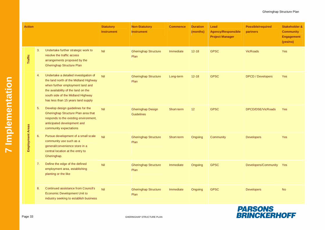
Gheringhap Structure Plan
Page 33 GHERINGHAP STRUCTURE PLAN
7 Im
plem
enta
tion
Action StatutoryInstrument
Non-StatutoryInstrument
Commence Duration(months)
LeadAgency/ResponsibleProject Manager
Possible/requiredpartners
Stakeholder &CommunityEngagement(yes/no)
Traf
fic
3. Undertake further strategic work toresolve the traffic accessarrangements proposed by the
Gheringhap Structure Plan
Nil Gheringhap Structure
Plan
Immediate 12-18 GPSC VicRoads Yes
Empl
oym
ent A
reas
4. Undertake a detailed investigation ofthe land north of the Midland Highwaywhen further employment land andthe availability of the land on thesouth side of the Midland Highwayhas less than 15 years land supply
Nil Gheringhap StructurePlan
Long-term 12-18 GPSC DPCD / Developers Yes
5. Develop design guidelines for theGheringhap Structure Plan area thatresponds to the existing environment,anticipated development andcommunity expectations
Nil Gheringhap DesignGuidelines
Short-term 12 GPSC DPCD/DSE/VicRoads Yes
6. Pursue development of a small scalecommunity use such as ageneral/convenience store in acentral location at the entry toGheringhap.
Nil Gheringhap StructurePlan
Short-term Ongoing Community Developers Yes
7. Define the edge of the definedemployment area, establishingplanting or the like
Nil Gheringhap StructurePlan
Immediate Ongoing GPSC Developers/Community Yes
8. Continued assistance from Council’sEconomic Development Unit toindustry seeking to establish business
Nil Gheringhap StructurePlan
Immediate Ongoing GPSC Developers No
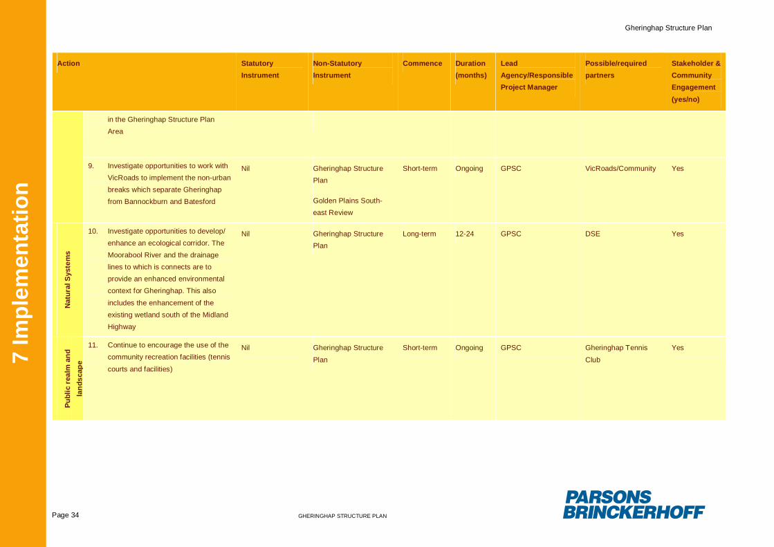
Gheringhap Structure Plan
Page 34 GHERINGHAP STRUCTURE PLAN
7 Im
plem
enta
tion
Action StatutoryInstrument
Non-StatutoryInstrument
Commence Duration(months)
LeadAgency/ResponsibleProject Manager
Possible/requiredpartners
Stakeholder &CommunityEngagement(yes/no)
in the Gheringhap Structure PlanArea
9. Investigate opportunities to work withVicRoads to implement the non-urbanbreaks which separate Gheringhapfrom Bannockburn and Batesford
Nil Gheringhap StructurePlan
Golden Plains South-east Review
Short-term Ongoing GPSC VicRoads/Community Yes
Nat
ural
Sys
tem
s
10. Investigate opportunities to develop/enhance an ecological corridor. TheMoorabool River and the drainagelines to which is connects are toprovide an enhanced environmentalcontext for Gheringhap. This also
includes the enhancement of theexisting wetland south of the MidlandHighway
Nil Gheringhap StructurePlan
Long-term 12-24 GPSC DSE Yes
Publ
ic r
ealm
and
land
scap
e
11. Continue to encourage the use of thecommunity recreation facilities (tennis
courts and facilities)
Nil Gheringhap Structure
Plan
Short-term Ongoing GPSC Gheringhap Tennis
Club
Yes
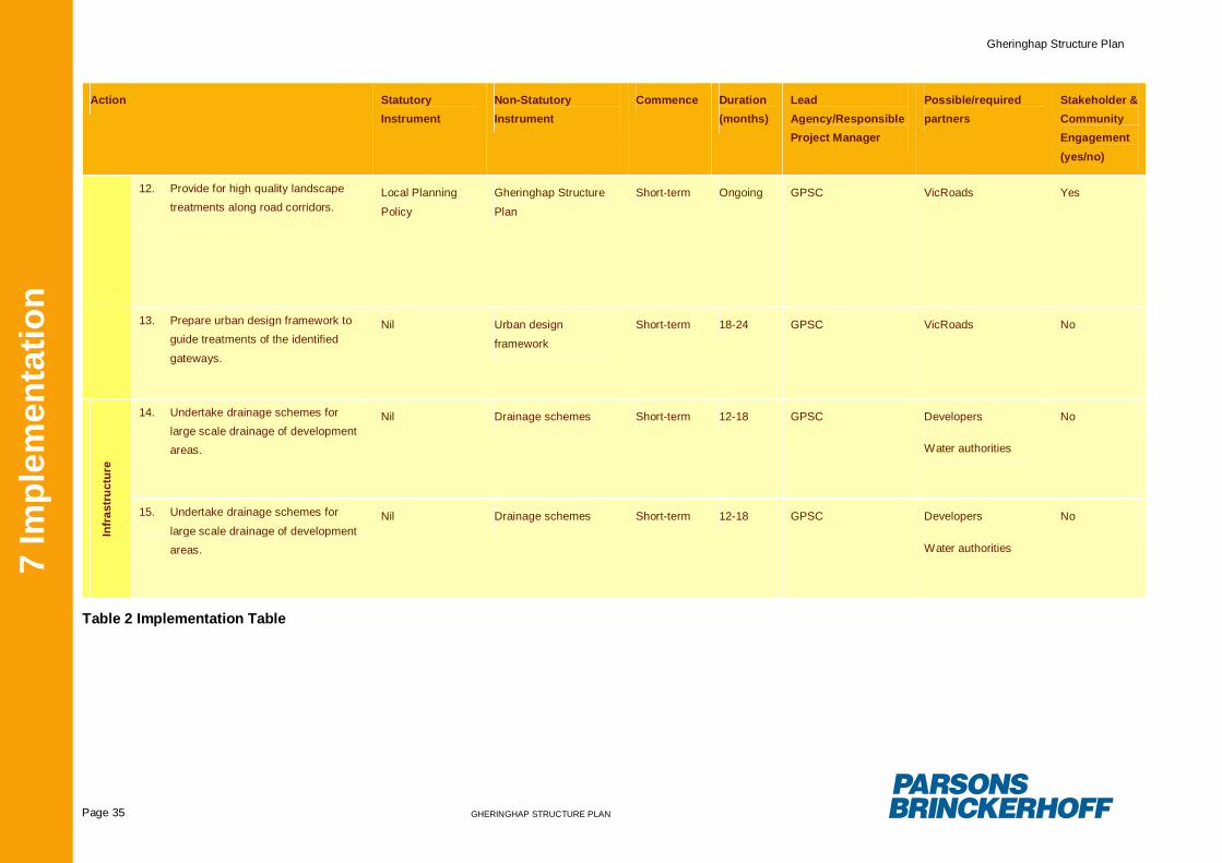
Gheringhap Structure Plan
Page 35 GHERINGHAP STRUCTURE PLAN
7 Im
plem
enta
tion
Action StatutoryInstrument
Non-StatutoryInstrument
Commence Duration(months)
LeadAgency/ResponsibleProject Manager
Possible/requiredpartners
Stakeholder &CommunityEngagement(yes/no)
12. Provide for high quality landscapetreatments along road corridors.
Local Planning
Policy
Gheringhap Structure
Plan
Short-term Ongoing GPSC VicRoads Yes
13. Prepare urban design framework toguide treatments of the identified
gateways.
Nil Urban design
framework
Short-term 18-24 GPSC VicRoads No
Infr
astr
uctu
re
14. Undertake drainage schemes forlarge scale drainage of developmentareas.
Nil Drainage schemes Short-term 12-18 GPSC Developers
Water authorities
No
15. Undertake drainage schemes for
large scale drainage of developmentareas.
Nil Drainage schemes Short-term 12-18 GPSC Developers
Water authorities
No
Table 2 Implementation Table
Gheringhap Structure Plan
Page 36 GHERINGHAP STRUCTURE PLAN
8 M
onito
ring
and
revi
ew8. Monitoring and review
In order to ensure the effectiveness and futurerelevance of this Structure Plan it is necessary forregular monitoring to be undertaken to assess itsperformance against the overall vision and guidingprinciples as set out in Section 5 and Section 6.1 ofthis Structure Plan. It is indeed an essential part ofthe implementation of this Structure Plan.
This Structure Plan has been prepared with a 20year horizon, while acknowledging that changes indemand are likely to occur and that the Plan mustbe responsive and adaptive over time. Therefore, itis necessary that several forms of monitoring becarried out during the implementation period of thisPlan. This includes the following:
Review and updating of the Structure Plan toensure its strategic directions remain up todate. The Structure Plan should be reviewedinitially in 5 years time to include anexamination of trends in the employment areatake-up and development. It should alsoinclude an analysis on needs andopportunities, the management of land useconflicts in the Region and changes inlegislation and land management practices thatmay require examination of specific directionsand recommendations.
Review of Planning Scheme zones, overlaycontrols and policies to ensure that the desiredoutcomes of the Structure Plan are beingsuccessfully implemented. This should beconducted with Council’s Senior StatutoryPlanners and include a review of Council’s
success in negotiating (including VCAT)positive development outcomes.
Providing additional guidance on key sites asrequired.
Monitoring of land uses and activity within theStructure Plan area.
Ongoing assessment of community needs andservices, particularly in relation to services andcommunity facilities.
Appendix A
Flora, Fauna and Cultural Heritage Details
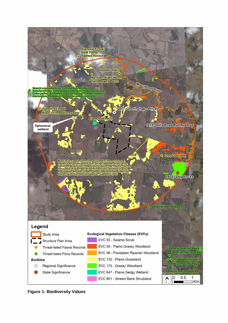
Figure 1: Biodiversity Values
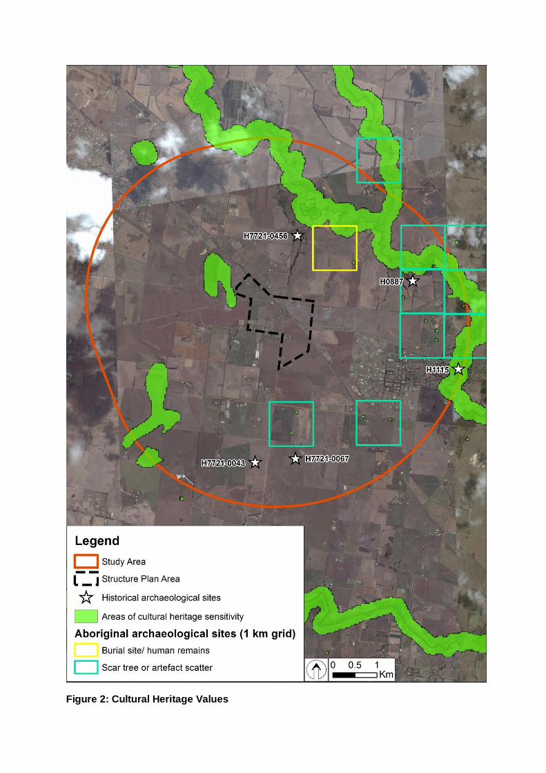
Figure 2: Cultural Heritage Values

Appendix B
Infrastructure Details
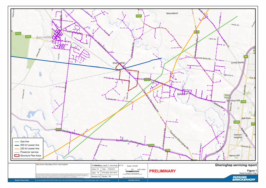
0 510 1,020 metres
1:70,000
Projection: Transverse MercatorCoordinate System: GDA 1994 MGA Zone 55
¯Scale Gheringhap servicing report
Figure 1Asset location mapEditor:
Date:
Drawing No.:
17/05/2012
TK
Revision: Review:A1
Author: TK
Print Date: 26/11/2012
PD
© Parsons Brinckerhoff Australia Pty Ltd ("PB") Copyright in the drawings, information and data recorded ("the information") is the property ofPB. This document and the information are solely for the use of the authorised recipient and this document may not be used, copied orreproduced in whole or part for any purpose other than that which it was supplied by PB. PB makes no representation, undertakes no dutyand accepts no responsibility to any third party who may use or rely upon this document or the information.NCSI Certified Quality System to ISO 9001. © APPROVED FOR AND ON BEHALF OF Parsons Brinckerhoff Australia Pty Ltd
Data Source: Bing Maps (2012), client supplied
Golden Plains Shire \\aumelf1\meldata\A553-ENVPLN\PROJ\2130598A_Golden_Plains_S\05_WrkPapers\GIS\Revised_Mapping_Nov_2012\Project\Gheringhap_AppB_F1_Servicing2_261112.mxd www.pb.com.au
Gas line500 kV power line220 kV power linePowercor serviceStructure Plan Area
Scale correct when printed at A4 Landscape
PRELIMINARYGheringhap_AppB_F1_Servicing2_261112
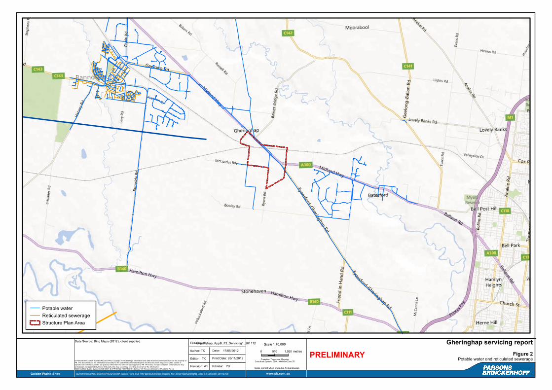
0 510 1,020 metres
1:70,000
Projection: Transverse MercatorCoordinate System: GDA 1994 MGA Zone 55
¯Scale Gheringhap servicing report
Figure 2Potable water and reticulated sewerageEditor:
Date:
Drawing No.:
17/05/2012
TK
Revision: Review:A1
Author: TK
Print Date: 26/11/2012
PD
© Parsons Brinckerhoff Australia Pty Ltd ("PB") Copyright in the drawings, information and data recorded ("the information") is the property ofPB. This document and the information are solely for the use of the authorised recipient and this document may not be used, copied orreproduced in whole or part for any purpose other than that which it was supplied by PB. PB makes no representation, undertakes no dutyand accepts no responsibility to any third party who may use or rely upon this document or the information.NCSI Certified Quality System to ISO 9001. © APPROVED FOR AND ON BEHALF OF Parsons Brinckerhoff Australia Pty Ltd
Data Source: Bing Maps (2012), client supplied
Golden Plains Shire \\aumelf1\meldata\A553-ENVPLN\PROJ\2130598A_Golden_Plains_S\05_WrkPapers\GIS\Revised_Mapping_Nov_2012\Project\Gheringhap_AppB_F2_Servicing1_261112.mxd www.pb.com.au
Potable waterReticulated sewerage Structure Plan Area
Scale correct when printed at A4 Landscape
PRELIMINARYGheringhap_AppB_F2_Servicing1_261112