draft teesdale structure plan
TRANSCRIPT
draft TEESDALE STRUCTURE PLAN 2019
background & issues report

TABLE OF CONTENTS
1 INTRODUCTION............................................... 4
2 NATURAL ENVIRONMENT................................ 6
2.1 Bushfire............................................................... 6
2.2 Rivers and Waterways........................................ 7
2.3 Topography......................................................... 7
2.4 Agricultural Land Qualities................................. 7
2.5 Flora and Fauna.................................................. 8
2.6 Street Trees......................................................... 8
3 URBAN ENVIRONMENT.................................... 9
3.1 Entrances to the Town........................................ 9
3.2 Street Lighting..................................................... 9
3.3 Crossings............................................................ 9
3.4 Buffers................................................................. 9
3.5 Sewer.................................................................. 10
3.6 Housing............................................................... 10
4 EXISTING STRATEGIES...................................... 11
4.1 Council Strategies............................................... 11
4.2 Teesdale Community Plan.................................. 12
4.3 G21 Regional Growth Plan................................. 12
5 PLANNING SCHEME ANALYSIS......................... 13
5.1 Zones.................................................................. 13
5.2 Overlays.............................................................. 14
5.3 State and Local Policy.......................................... 14
6 SUPPLY AND DEMAND..................................... 16
7 DEMOGRAPHICS AND HOUSING PROFILE........ 20
7.1 Demographics Overview..................................... 20
7.2 Method of Travel to work.................................. 21
8 COMMERCIAL LAND........................................ 22
9 COMMUNITY INFRASTRUCTURE & OPEN SPACE..............................................................
23
10 CONNECTION TO OTHER TOWNS & CITIES....... 24
11 HERITAGE...................................................... 26
12 KEY FINDINGS................................................ 28
4 TEESDALE STRUCTURE PLAN
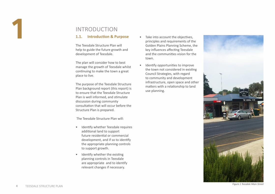
1 INTRODUCTION1.1. Introduction & Purpose
The Teesdale Structure Plan will help to guide the future growth and development of Teesdale.
The plan will consider how to best manage the growth of Teesdale whilst continuing to make the town a great place to live.
The purpose of the Teesdale Structure Plan background report (this report) is to ensure that the Teesdale Structure Plan is well informed, and stimulate discussion during community consultation that will occur before the Structure Plan is prepared.
The Teesdale Structure Plan will:
• Identify whether Teesdale requires additional land to support future residential or commercial development, and if so to identify the appropriate planning controls to support growth.
• Identify whether the existing planning controls in Teesdale are appropriate and to identify relevant changes if necessary.
• Take into account the objectives, principles and requirements of the Golden Plains Planning Scheme, the key influences affecting Teesdale and the communities vision for the town.
Figure 1 Teesdale Main Street
• Identify opportunities to improve the town not considered in existing Council Strategies, with regard to community and development infrastructure, open space and other matters with a relationship to land use planning.
5 TEESDALE STRUCTURE PLANFigure 1 Teesdale Main Street
About this Document: This map has been created for the purpose of showing basic locality information over Golden Plains Shire Council. Cadastral information has been provided by Land Victoria and may not accurately reflect true title status and/or boundary definition.
Disclaimer: This map is a representation of the information currently held by Golden Plains Shire Council. While every effort has been made to ensure the accuracy of the product, Council accepts no responsibility for any errors or omissions.0
0 100 200 300 400 500
DON WALLACE RESERVE
NATURERESERVE
TEESDALE TIP
TEESDALE \CEMETERY
TEESDALE PRIMARY
BANNOCKBURN-SHELFORD RD
LEIGHDALE EQUESTRIAN
CENTRE
TEES
DALE
-LET
HBRI
DGE
RD
BAKE
RS L
ANE
TE
ES
DA
LE T
IP R
D
To Geelong
To Shelford
TURTLE BEND
TEESDALE GENERAL STORE
BANNOCKBURN-SHELFORD RD
TEES
DALE
-INVE
RLEI
GH R
D
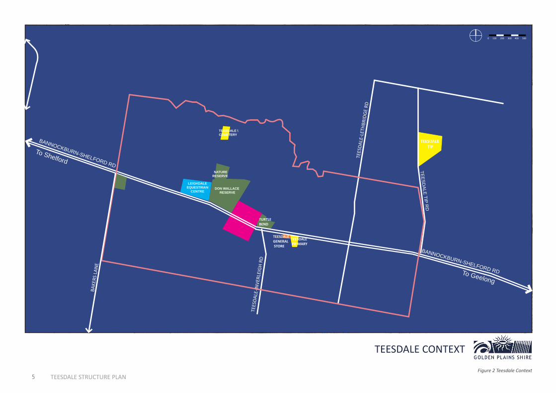
TEESDALE CONTEXT
Figure 2 Teesdale Context
6 TEESDALE STRUCTURE PLAN
NATURAL ENVIRONMENT2.1 BushfireThe Teesdale Sheoak Nature Conservation Reserve and the Don Wallace Reserve (contiguous) within the town are the areas with the highest fuel load. This is predominantly where the Bushfire Management Overlay (BMO) applies in addition to land in the north west corner. Typically the BMO applies to the areas at the greatest level of bushfire risk, though it does not capture all levels of risk.
Many private properties have a significant number of trees, as backyards in the town are typically large. There is also a significant number of treed areas along Native Hut Creek. A Department of Environment Land Water and Planning (DELWP) managed site known as “Chinaman’s Lagoon” on the southern side of township is also densely treed.
Teesdale generally borders farmland. Grassfire remains a risk from farming areas on the edge of the town, however grassfire would not likely result in the same level of damage as a bushfire from areas of dense trees/shrubs.
In terms of the wider area, approximately 1.6km to the south of town is the Inverleigh Flora and Fauna Conservation Reserve, which is a large
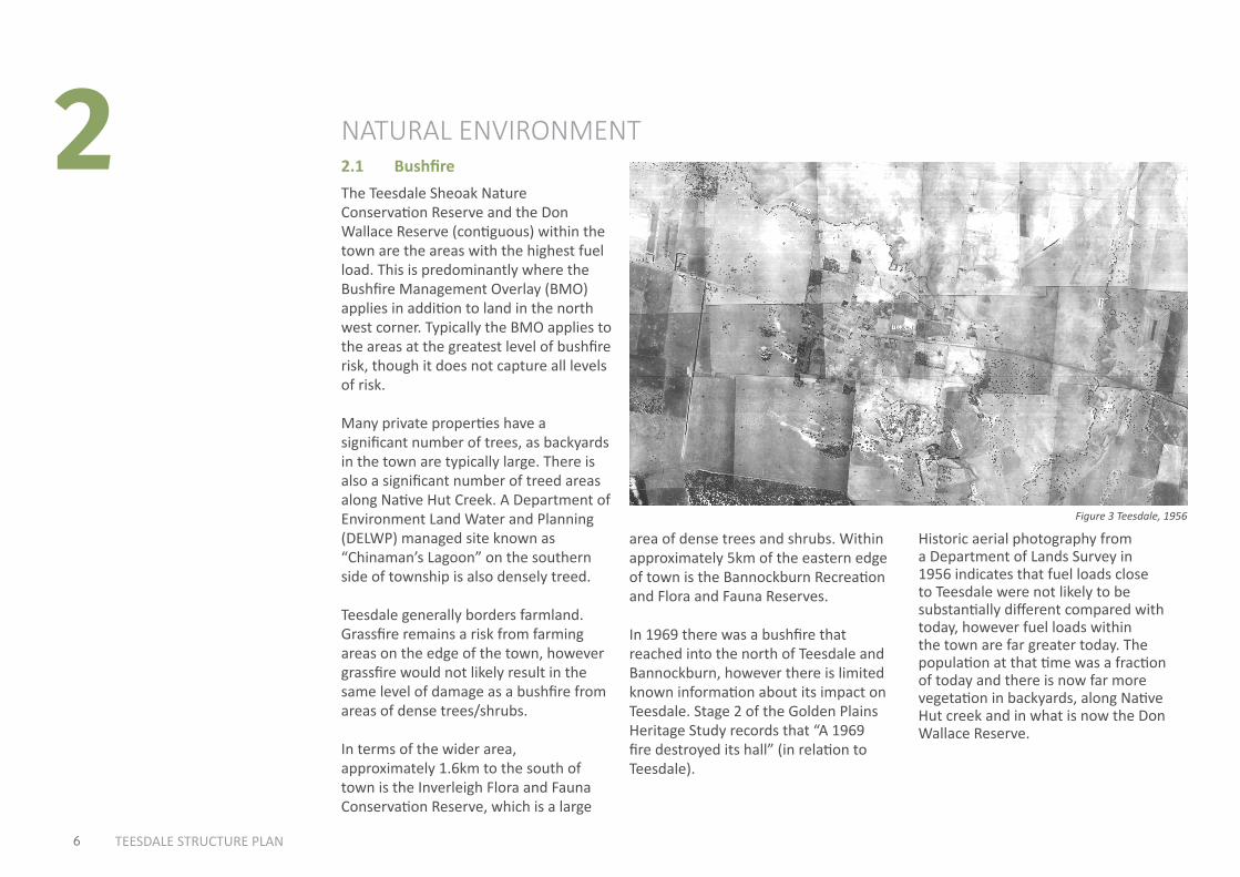
Historic aerial photography from a Department of Lands Survey in 1956 indicates that fuel loads close to Teesdale were not likely to be substantially different compared with today, however fuel loads within the town are far greater today. The population at that time was a fraction of today and there is now far more vegetation in backyards, along Native Hut creek and in what is now the Don Wallace Reserve.
2
area of dense trees and shrubs. Within approximately 5km of the eastern edge of town is the Bannockburn Recreation and Flora and Fauna Reserves.
In 1969 there was a bushfire that reached into the north of Teesdale and Bannockburn, however there is limited known information about its impact on Teesdale. Stage 2 of the Golden Plains Heritage Study records that “A 1969 fire destroyed its hall” (in relation to Teesdale).
Figure 3 Teesdale, 1956

7 TEESDALE STRUCTURE PLAN
not been flood mapped but is understood to warrant consideration for possible flood impacts.
2.3 TopographyThe majority of Teesdale is quite flat however there are significant undulating areas that run through the centre of the town in a north-south direction, including along native hut creek.
Whilst the fuel loads from trees and shrubs inside or within the vicinity of the town are significant, they are by no means unusual for regional Victoria. Along with the vast majority of regional Victoria, Teesdale is classified as a designated “Bushfire Prone Area”. Development in a designated Bushfire Prone Area must comply with construction standards under AS3959 Construction of Buildings in Bushfire Prone Areas.
2.2 Rivers and WaterwaysThe main waterway that runs through Teesdale is the Native Hut Creek. A number of smaller waterways run through the town and across property boundaries.
Some of the land in the vicinity of native hut creek is flood prone as recognised in current Land Subject to Inundation Overlay and Floodway Overlay mapping.
The Corangamite Catchment Management Authority (CCMA) have indicated that the current flood mapping for Native Hut Creek is out of date. A study on the flood susceptibility of the Native Hut Creek has been developed and the CCMA are currently organising a peer review. Upon finalisation, a Planning Scheme Amendment is likely to be required to implement the new mapping.
In addition a tributary that crosses Jolly’s road and leads into native hut creek has
About this Document: This map has been created for the purpose of showing basic locality information over Golden Plains Shire Council. Cadastral information has been provided by Land Victoria and may not accurately reflect true title status and/or boundary definition.
Disclaimer: This map is a representation of the information currently held by Golden Plains Shire Council. While every effort has been made to ensure the accuracy of the product, Council accepts no responsibility for any errors or omissions.0
Teesdale with 1 metre contour (height) lines is depicted in figure 4 above.
2.4 Agricultural Land QualitiesTeesdale is mostly surrounded by agricultural land. The State Government is undertaking a project to identify, recognise and protect agricultural land within 100km of the Melbourne CBD, an area that includes Teesdale.
An area to the south east of Teesdale has been recognised as strategic agricultural land in the first iteration of the mapping – however the mapping has not been finalised. The State Government has indicated that in future strategic agricultural land will be protected.
Figure 4 Teesdale with 1m contours
8 TEESDALE STRUCTURE PLAN
About this Document: This map has been created for the purpose of showing basic locality information over Golden Plains Shire Council. Cadastral information has been provided by Land Victoria and may not accurately reflect true title status and/or boundary definition.
Disclaimer: This map is a representation of the information currently held by Golden Plains Shire Council. While every effort has been made to ensure the accuracy of the product, Council accepts no responsibility for any errors or omissions.0
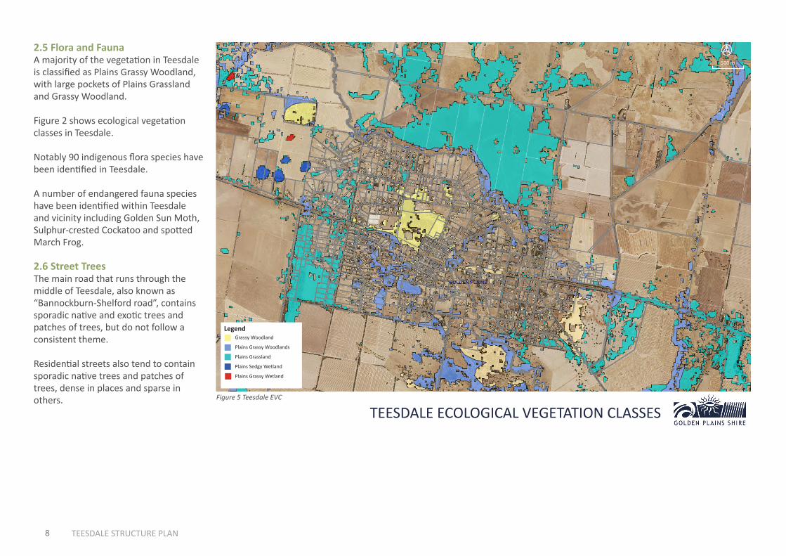
2.5 Flora and FaunaA majority of the vegetation in Teesdale is classified as Plains Grassy Woodland, with large pockets of Plains Grassland and Grassy Woodland.
Figure 2 shows ecological vegetation classes in Teesdale.
Notably 90 indigenous flora species have been identified in Teesdale.
A number of endangered fauna species have been identified within Teesdale and vicinity including Golden Sun Moth, Sulphur-crested Cockatoo and spotted March Frog.
2.6 Street TreesThe main road that runs through the middle of Teesdale, also known as “Bannockburn-Shelford road”, contains sporadic native and exotic trees and patches of trees, but do not follow a consistent theme.
Residential streets also tend to contain sporadic native trees and patches of trees, dense in places and sparse in others. Figure 5 Teesdale EVC
LegendGrassy Woodland
Plains Grassy Woodlands
Plains Grassland
Plains Sedgy Wetland
Plains Grassy Wetland
500 m
TEESDALE ECOLOGICAL VEGETATION CLASSES
3
9 TEESDALE STRUCTURE PLAN
3.1 Entrances to the TownURBAN ENVIRONMENTThe entrance to Teesdale along Bannockburn-Shelford Road from Bannockburn contains large amounts of native vegetation on arrival, including in private properties on the southern side. There is a 150m stretch of gravel on the northern side of the road upon approach just before Teesdale-Lethbridge road, which is of unknown purpose/history. There are gravel mounds in this area. There is no entrance feature or sign. It becomes more evident that one is entering a town at the intersection of Bannockburn-Shelford road and Mercer St, where there is a bus stop and it is possible to see a number dwellings.
The entrance to Teesdale from Shelford includes wide road reserves with fairly dense vegetation in parts. There is minimal evidence of entering a town.
3.2 Street LightingCurrently there is no street lighting in the older parts of Teesdale, including along the main road. In newer low density developments street lighting is generally required at key intersections, where there are sharp bends in roads and at the end of court bowls.
3.3 CrossingsThere are no zebra crossings in Teesdale, however there is a crossing area on the main road in front of the primary school.
BuffersThis section reviews land uses and natural features in and around Teesdale with possible buffer implications if land was ever developed in the vicinity of these uses.
Former LandfillTeesdale contains a former landfill within the identified “Low Density Environmental Living” area, identified for potential growth in the 1997 structure plan.
The default EPA buffer requirement for a closed landfill is for a 500 metre buffer to the landfill cells (if known) or otherwise to the site boundary.
EPA guidelines provide the potential for reduced buffers subject to environmental audits.
Native Hut CreekSubdivision in the vicinity of a waterway generally requires a buffer of 10-50
metres. The buffer distance will vary depending on the circumstances. The Corangamite Catchment Management Authority is the key advice giver that assists Council with determining the appropriate buffer distance.
Poultry FarmsThere are poultry farms north of Tees-dale. Clause 53.09 (Poultry Farm) of the Golden Plains Planning Scheme indicates that farms with over 1000 chickens re-quire a distance of at least 400 metres to land in a residential zone, while small-er farms require at least a 200 metre distance.
Sand QuarryThere is a small sand quarry operating on rural land approximately 1.6km south east of the south eastern edge of the town. A specific buffer distance for this type of facility is not explicit in the plan-ning scheme, nonetheless it would be a relevant consideration.
10 TEESDALE STRUCTURE PLAN
The vast majority of Teesdale is situated within the Low Density Residential Zone, which has a 4000 square metre minimum lot size for unsewered properties and 2000 square metres for sewered properties.
The installation of reticulated sewer is costly. In the case of the Smythesdale sewer scheme, land owners faced a cost in the vicinity of $3000 - $6000 per property in addition to the cost of decommissioning their existing septic system. There is an ongoing charge for sewer, currently $141.33 per quarter.
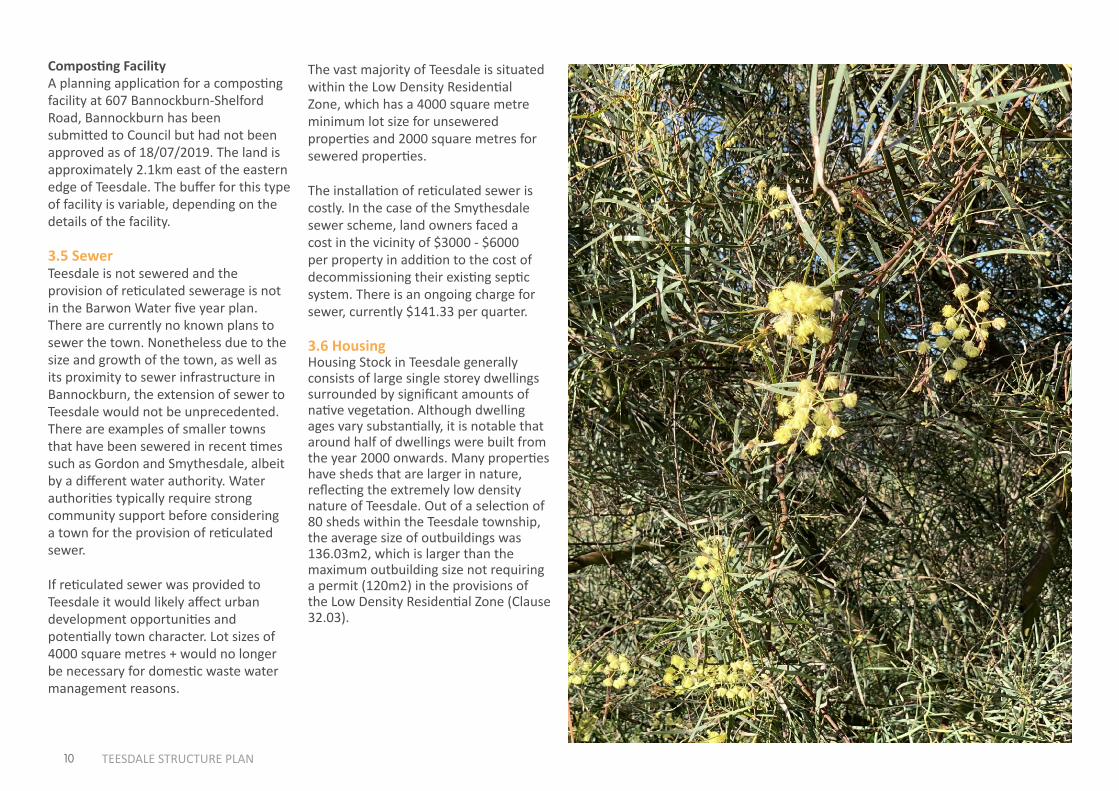
3.6 HousingHousing Stock in Teesdale generally consists of large single storey dwellings surrounded by significant amounts of native vegetation. Although dwelling ages vary substantially, it is notable that around half of dwellings were built from the year 2000 onwards. Many properties have sheds that are larger in nature, reflecting the extremely low density nature of Teesdale. Out of a selection of 80 sheds within the Teesdale township, the average size of outbuildings was 136.03m2, which is larger than the maximum outbuilding size not requiring a permit (120m2) in the provisions of the Low Density Residential Zone (Clause 32.03).
Composting FacilityA planning application for a composting facility at 607 Bannockburn-Shelford Road, Bannockburn has been submitted to Council but had not been approved as of 18/07/2019. The land is approximately 2.1km east of the eastern edge of Teesdale. The buffer for this type of facility is variable, depending on the details of the facility.
3.5 SewerTeesdale is not sewered and the provision of reticulated sewerage is not in the Barwon Water five year plan. There are currently no known plans to sewer the town. Nonetheless due to the size and growth of the town, as well as its proximity to sewer infrastructure in Bannockburn, the extension of sewer to Teesdale would not be unprecedented. There are examples of smaller towns that have been sewered in recent times such as Gordon and Smythesdale, albeit by a different water authority. Water authorities typically require strong community support before considering a town for the provision of reticulated sewer.
If reticulated sewer was provided to Teesdale it would likely affect urban development opportunities and potentially town character. Lot sizes of 4000 square metres + would no longer be necessary for domestic waste water management reasons.
4
11 TEESDALE STRUCTURE PLAN
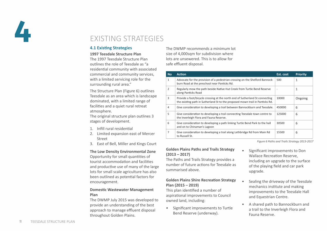
4.1 Existing Strategies
EXISTING STRATEGIESThe DWMP recommends a minimum lot size of 4,000sqm for subdivision where lots are unsewered. This is to allow for safe effluent disposal.
Golden Plains Paths and Trails Strategy (2013 – 2017) The Paths and Trails Strategy provides a number of future actions for Teesdale as summarised above.
Golden Plains Shire Recreation Strategy Plan (2015 – 2019)This plan identified a number of aspirational improvements to Council owned land, including:
• Significant improvements to Turtle Bend Reserve (underway).
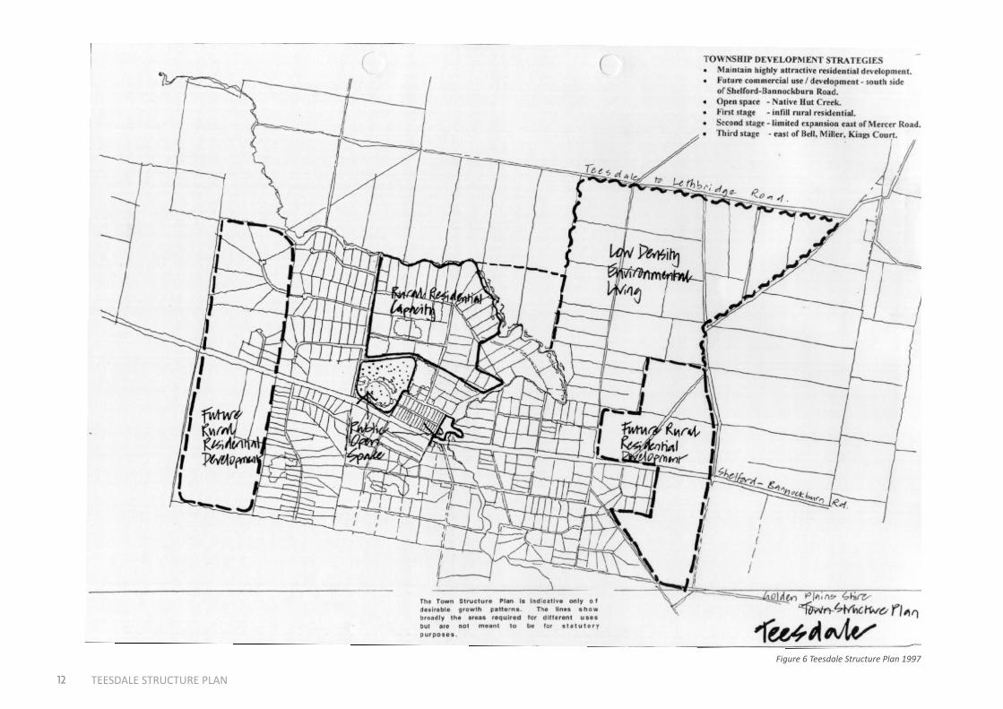
1997 Teesdale Structure PlanThe 1997 Teesdale Structure Plan outlines the role of Teesdale as “a residential community with associated commercial and community services, with a limited servicing role for the surrounding rural area.”The Structure Plan (Figure 6) outlines Teesdale as an area which is landscape dominated, with a limited range of facilities and a quiet rural retreat atmosphere. The original structure plan outlines 3 stages of development.
1. Infill rural residential2. Limited expansion east of Mercer
Street3. East of Bell, Miller and Kings Court
The Low Density Environmental ZoneOpportunity for small quantities of tourist accommodation and facilities and productive use of many of the large lots for small scale agriculture has also been outlined as potential factors for encouragement.
Domestic Wastewater Management PlanThe DWMP July 2015 was developed to provide an understanding of the best approach to manage effluent disposal throughout Golden Plains.
• Significant improvements to Don Wallace Recreation Reserve, including an upgrade to the surface of the playing field and car park upgrade.
• Sealing the driveway of the Teesdale mechanics institute and making improvements to the Teesdale Hall and Equestrian Centre.
• A shared path to Bannockburn and a trail to the Inverleigh Flora and Fauna Reserve.
No Action Est. cost Priority1 Advocate for the provision of a pedestrian crossing on the Shelford Bannock-
burn Road at the preschool near Panticks Rd. 500 1
2 Regularly mow the path beside Native Hut Creek from Turtle Bend Reserve along Panticks Road
- 1
3 Provide a foot/bicycle crossing at the north end of Sutherland St connecting the existing path in Sutherland St to the proposed mown trail in Panticks Rd.
10000 Ongoing
4 Give consideration to developing a trail between Bannockburn and Teesdale. 450000 6
5 Give consideration to developing a trail connecting Teesdale town centre to the Inverleigh Flora and Fauna Reserve.
125000 6
6 Give consideration to developing a path linking Turtle Bend Park to the hall and on to Chinaman’s Lagoon
30500 6
7 Give consideration to developing a trail along Lethbridge Rd from Main Rd to Russell St.
15500 6
Figure 6 Paths and Trails Strategy 2013-2017
12 TEESDALE STRUCTURE PLAN
21.08-1421/12/2017C
76
Teesdale
Stru
cture
Plan
GO
LD
EN
PL
AIN
SP
LA
NN
ING
SC
HE
ME
Page 15 of 15
Figure 6 Teesdale Structure Plan 1997
13 TEESDALE STRUCTURE PLAN
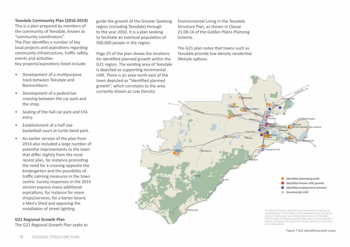
Teesdale Community Plan (2016-2019)This is a plan prepared by members of the community of Teesdale, known as “community coordinators”. The Plan identifies a number of key local projects and aspirations regarding community infrastructure, traffic safety, events and activities. Key projects/aspirations listed include:
• Development of a multipurpose track between Teesdale and Bannockburn.
• Development of a pedestrian crossing between the car park and the shop.
• Sealing of the hall car park and CFA entry.
• Establishment of a half size basketball court at turtle bend park.
• An earlier version of the plan from 2014 also included a large number of potential improvements to the town that differ slightly from the most recent plan, for instance promoting the need for a crossing opposite the kindergarten and the possibility of traffic calming measures in the town centre. Survey responses in the 2014 version express many additional aspirations, for instance for more shops/services, for a barter board, a Men’s Shed and opposing the installation of street lighting.
G21 Regional Growth PlanThe G21 Regional Growth Plan seeks to
4.0 THE G21 REGIONAL GROWTH PLAN
the G21 councils have alReady Planned foR the ReGion to GRow to oveR 450,000 PeoPle
Local Government Area 2011 Population Planned Additional Population
Total
city of greater geelong 223,047 168,531 388,599
surf coast shire 26,873 22,443 48,616
golden plains shire 19,014 14,603 33,228
colac otway shire 22,108 5377 27,474
borough of queenscliffe 3306 - 3306
TOTAL 294,348 210,954 505,302
MAP 6 - IDENTIFIED PLANNED GROWTH
these figures will be reviewed as additional information becomes available, including udp 2011 data. only settlements with planned growth are shown. planned growth capacity in structure plans is generally intended to be taken up over a 20 year+ timeframe.
identified planned growth
identified known infill growth
identified employment precinct
incremental infill
the state of victoria and g21 do not warrant the accuracy or completeness of information in this publication and any person using or relying upon such information does so on the basis that the state of victoria and g21 shall bear no responsibility or liability whatsoever for any errors, faults, defects or omissions in the information.
25g21 REgIONAL gROWTH PLAN
Apollo bay
lorne
forrest
Anglesea
torquay/jan juc
ocean grove queenscliff
st leonards
portarlington
dysdale/ clifton springs
leopold
central geelongwest
fyans
corio norlane
Armstrong creekmoriac
princes hwy
surf
coa
st h
wy
bellarine hwy
portarlington rd
princes hwy
hamilton hwy
hamilton hwy
princes fwy
midland hwy
winchelsea
birregurracolac
inverleigh
lethbridge
bannockburn
lara
little river
teesdale
guide the growth of the Greater Geelong region (including Teesdale) through to the year 2050. It is a plan seeking to facilitate an eventual population of 500,000 people in the region.
Page 25 of the plan shows the locations for identified planned growth within the G21 region. The existing area of Teesdale is depicted as supporting incremental infill. There is an area north east of the town depicted as “Identified planned growth”, which correlates to the area currently shown as Low Density
Environmental Living in the Teesdale Structure Plan, as shown in Clause 21.08-14 of the Golden Plains Planning Scheme.
The G21 plan notes that towns such as Teesdale provide low density residential lifestyle options.
Figure 7 G21 Identified growth areas
5
14 TEESDALE STRUCTURE PLAN
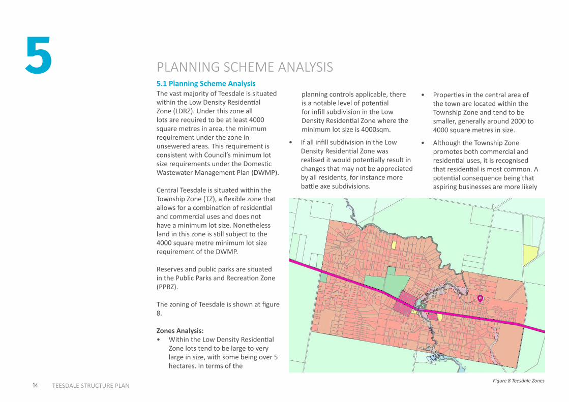
5.1 Planning Scheme Analysis
PLANNING SCHEME ANALYSIS
The vast majority of Teesdale is situated within the Low Density Residential Zone (LDRZ). Under this zone all lots are required to be at least 4000 square metres in area, the minimum requirement under the zone in unsewered areas. This requirement is consistent with Council’s minimum lot size requirements under the Domestic Wastewater Management Plan (DWMP).
Central Teesdale is situated within the Township Zone (TZ), a flexible zone that allows for a combination of residential and commercial uses and does not have a minimum lot size. Nonetheless land in this zone is still subject to the 4000 square metre minimum lot size requirement of the DWMP.
Reserves and public parks are situated in the Public Parks and Recreation Zone (PPRZ).
The zoning of Teesdale is shown at figure 8.
Zones Analysis: • Within the Low Density Residential
Zone lots tend to be large to very large in size, with some being over 5 hectares. In terms of the
planning controls applicable, there is a notable level of potential for infill subdivision in the Low Density Residential Zone where the minimum lot size is 4000sqm.
• If all infill subdivision in the Low Density Residential Zone was realised it would potentially result in changes that may not be appreciated by all residents, for instance more battle axe subdivisions.
• Properties in the central area of the town are located within the Township Zone and tend to be smaller, generally around 2000 to 4000 square metres in size.
• Although the Township Zone promotes both commercial and residential uses, it is recognised that residential is most common. A potential consequence being that aspiring businesses are more likely
Figure 8 Teesdale Zones
15 TEESDALE STRUCTURE PLANFigure 8 Teesdale Zones
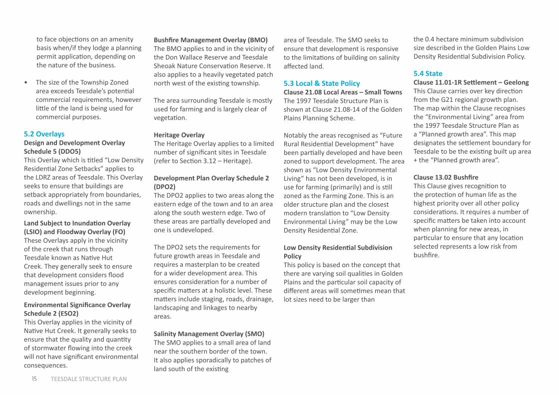
Bushfire Management Overlay (BMO)The BMO applies to and in the vicinity of the Don Wallace Reserve and Teesdale Sheoak Nature Conservation Reserve. It also applies to a heavily vegetated patch north west of the existing township.
The area surrounding Teesdale is mostly used for farming and is largely clear of vegetation.
Heritage OverlayThe Heritage Overlay applies to a limited number of significant sites in Teesdale (refer to Section 3.12 – Heritage).
Development Plan Overlay Schedule 2 (DPO2) The DPO2 applies to two areas along the eastern edge of the town and to an area along the south western edge. Two of these areas are partially developed and one is undeveloped.
The DPO2 sets the requirements for future growth areas in Teesdale and requires a masterplan to be created for a wider development area. This ensures consideration for a number of specific matters at a holistic level. These matters include staging, roads, drainage, landscaping and linkages to nearby areas.
Salinity Management Overlay (SMO) The SMO applies to a small area of land near the southern border of the town. It also applies sporadically to patches of land south of the existing
to face objections on an amenity basis when/if they lodge a planning permit application, depending on the nature of the business.
• The size of the Township Zoned area exceeds Teesdale’s potential commercial requirements, however little of the land is being used for commercial purposes.
5.2 OverlaysDesign and Development Overlay Schedule 5 (DDO5)This Overlay which is titled “Low Density Residential Zone Setbacks” applies to the LDRZ areas of Teesdale. This Overlay seeks to ensure that buildings are setback appropriately from boundaries, roads and dwellings not in the same ownership. Land Subject to Inundation Overlay (LSIO) and Floodway Overlay (FO)These Overlays apply in the vicinity of the creek that runs through Teesdale known as Native Hut Creek. They generally seek to ensure that development considers flood management issues prior to any development beginning.
Environmental Significance Overlay Schedule 2 (ESO2)This Overlay applies in the vicinity of Native Hut Creek. It generally seeks to ensure that the quality and quantity of stormwater flowing into the creek will not have significant environmental consequences.
area of Teesdale. The SMO seeks to ensure that development is responsive to the limitations of building on salinity affected land.
5.3 Local & State PolicyClause 21.08 Local Areas – Small TownsThe 1997 Teesdale Structure Plan is shown at Clause 21.08-14 of the Golden Plains Planning Scheme.
Notably the areas recognised as “Future Rural Residential Development” have been partially developed and have been zoned to support development. The area shown as “Low Density Environmental Living” has not been developed, is in use for farming (primarily) and is still zoned as the Farming Zone. This is an older structure plan and the closest modern translation to “Low Density Environmental Living” may be the Low Density Residential Zone.
Low Density Residential Subdivision PolicyThis policy is based on the concept that there are varying soil qualities in Golden Plains and the particular soil capacity of different areas will sometimes mean that lot sizes need to be larger than
the 0.4 hectare minimum subdivision size described in the Golden Plains Low Density Residential Subdivision Policy.
5.4 StateClause 11.01-1R Settlement – GeelongThis Clause carries over key direction from the G21 regional growth plan. The map within the Clause recognises the “Environmental Living” area from the 1997 Teesdale Structure Plan as a “Planned growth area”. This map designates the settlement boundary for Teesdale to be the existing built up area + the “Planned growth area”.
Clause 13.02 BushfireThis Clause gives recognition to the protection of human life as the highest priority over all other policy considerations. It requires a number of specific matters be taken into account when planning for new areas, in particular to ensure that any location selected represents a low risk from bushfire.
6
16 TEESDALE STRUCTURE PLAN
6.1 Demand
SUPPLY & DEMAND
Between the 2011 to 2016 census Teesdale grew from 1479 to 1664 residents. This represents average annual population growth of 37 people or 2.5%. The average Teesdale household contains 2.9 residents. This means that in 2018 there would have been demand for approximately 13 dwellings (37 new residents/average household size = 12.7). If the 2.5% growth rate continues then over time the number of dwellings needed in a year will gradually increase.
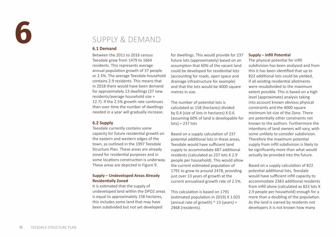
6.2 SupplyTeesdale currently contains some capacity for future residential growth on the eastern and western edges of the town, as outlined in the 1997 Teesdale Structure Plan. These areas are already zoned for residential purposes and in some locations construction is underway. These areas are depicted in Figure 9.
Supply – Undeveloped Areas Already Residentially ZonedIt is estimated that the supply of undeveloped land within the DPO2 areas is equal to approximately 158 hectares, this includes some land that may have been subdivided but not yet developed
for dwellings. This would provide for 237 future lots (approximately) based on an assumption that 60% of the vacant land could be developed for residential lots (accounting for roads, open space and drainage infrastructure for example) and that the lots would be 4000 square metres in size.
The number of potential lots is calculated as 158 (hectares) divided by 0.4 (size of lots in hectares) X 0.6 (assuming 60% of land is developable for lots) = 237 lots
Based on a supply calculation of 237 potential additional lots in these areas, Teesdale would have sufficient land supply to accommodate 687 additional residents (calculated as 237 lots X 2.9 people per household). This would allow the current estimated population of 1791 to grow to around 2478, providing just over 13 years of growth at the current annualised growth rate of 2.5%.
This calculation is based on 1791 (estimated population in 2019) X 1.025 (annual rate of growth) ^ 13 (years) = 2468 (residents).
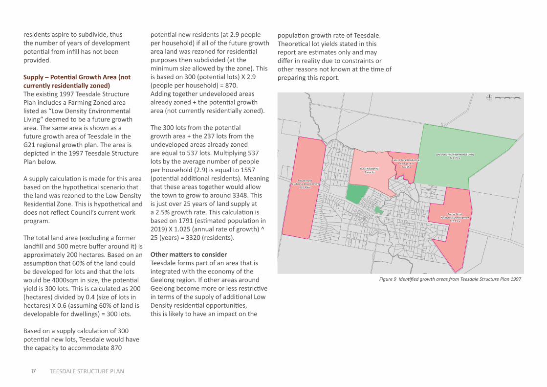
Supply – Infill PotentialThe physical potential for infill subdivision has been analysed and from this it has been identified that up to 822 additional lots could be yielded, if all existing residential allotments were resubdivided to the maximum extent possible. This is based on a high level (approximate) analysis taking into account known obvious physical constraints and the 4000 square minimum lot size of the Zone. There are potentially other constraints not known to the authors. Furthermore the intentions of land owners will vary, with some unlikely to consider subdivision. Therefore the maximum potential supply from infill subdivision is likely to be significantly more than what would actually be provided into the future.
Based on a supply calculation of 822 potential additional lots, Teesdale would have sufficient infill capacity to accommodate 2383 additional residents from infill alone (calculated as 822 lots X 2.9 people per household) enough for a more than a doubling of the population. As the land is owned by residents not developers it is not known how many
17 TEESDALE STRUCTURE PLAN
potential new residents (at 2.9 people per household) if all of the future growth area land was rezoned for residential purposes then subdivided (at the minimum size allowed by the zone). This is based on 300 (potential lots) X 2.9 (people per household) = 870. Adding together undeveloped areas already zoned + the potential growth area (not currently residentially zoned).
The 300 lots from the potential growth area + the 237 lots from the undeveloped areas already zoned are equal to 537 lots. Multiplying 537 lots by the average number of people per household (2.9) is equal to 1557 (potential additional residents). Meaning that these areas together would allow the town to grow to around 3348. This is just over 25 years of land supply at a 2.5% growth rate. This calculation is based on 1791 (estimated population in 2019) X 1.025 (annual rate of growth) ^ 25 (years) = 3320 (residents).
Other matters to considerTeesdale forms part of an area that is integrated with the economy of the Geelong region. If other areas around Geelong become more or less restrictive in terms of the supply of additional Low Density residential opportunities, this is likely to have an impact on the
residents aspire to subdivide, thus the number of years of development potential from infill has not been provided.
Supply – Potential Growth Area (not currently residentially zoned) The existing 1997 Teesdale Structure Plan includes a Farming Zoned area listed as “Low Density Environmental Living” deemed to be a future growth area. The same area is shown as a future growth area of Teesdale in the G21 regional growth plan. The area is depicted in the 1997 Teesdale Structure Plan below.
A supply calculation is made for this area based on the hypothetical scenario that the land was rezoned to the Low Density Residential Zone. This is hypothetical and does not reflect Council’s current work program.
The total land area (excluding a former landfill and 500 metre buffer around it) is approximately 200 hectares. Based on an assumption that 60% of the land could be developed for lots and that the lots would be 4000sqm in size, the potential yield is 300 lots. This is calculated as 200 (hectares) divided by 0.4 (size of lots in hectares) X 0.6 (assuming 60% of land is developable for dwellings) = 300 lots.
Based on a supply calculation of 300 potential new lots, Teesdale would have the capacity to accommodate 870
population growth rate of Teesdale. Theoretical lot yields stated in this report are estimates only and may differ in reality due to constraints or other reasons not known at the time of preparing this report.
About this Document: This map has been created for the purpose of showing basic locality information over Golden Plains Shire Council. Cadastral information has been provided by Land Victoria and may not accurately reflect true title status and/or boundary definition.
Disclaimer: This map is a representation of the information currently held by Golden Plains Shire Council. While every effort has been made to ensure the accuracy of the product, Council accepts no responsibility for any errors or omissions.0
Low Density Environmental Living321.55ha
Future Rural Residential Development
228.46ha
Future Rural Residential Development
172.13ha
Future Rural Residential Development
47.31haRural Residential
Capacity
0 100 200 300 400 500m
Figure 9 Identified growth areas from Teesdale Structure Plan 1997

18 TEESDALE STRUCTURE PLAN
500 m
8,000-12,00012,001-16,00016,001-20,00020,001-24,00024,001-28,00028,001-32,00032,001-36,00036,001-40,00040,000 +
LDRZ lots with infill potential (m2)
Teesdale LDRZ - Infill Potential
LDRZFZ
Legend
PPRZTZPUZ
BANNOCKBURN-SHELFORD ROAD
TE
ES
DA
LE
-LE
TH
BR
IDG
E R
OA
D
ME
RE
DIT
H-S
HE
LF
OR
D R
OA
D
BA
KE
RS
LA
NE
TEE
SD
ALE
-INV
ER
LEIG
H R
OA
D
TEESDALE LDRZ - INFILL POTENTIAL (MAXIMUM YIELD SCENARIO)
300
250200150100
500
8,000-12,000m2
12,001-16,000m2
16,001-20,000m2
20,001-24,000m2
24,001-28,000m2
28,001-32,000m2
32,001-36,000 m2
36,001-40,000 m2
Over 40,000m
2
NO. OF POTENTIAL LOTS CREATED
170 163
10056 43 37
64 41
148
Figure 10 Infill potential in Teesdale
19 TEESDALE STRUCTURE PLAN
About this Document: This map has been created for the purpose of showing basic locality information over Golden Plains Shire Council. Cadastral information has been provided by Land Victoria and may not accurately reflect true title status and/or boundary definition.
Disclaimer: This map is a representation of the information currently held by Golden Plains Shire Council. While every effort has been made to ensure the accuracy of the product, Council accepts no responsibility for any errors or omissions.0
LDRZFZ
Legend
PPRZTZ
500 m
Teesdale - New dwellings constructed January 2014 - March 2019
Dwellings constructed2014-2019
New Dwelling
PUZ
BANNOCKBURN-SHELFORD ROAD
TE
ES
DA
LE
-LE
TH
BR
IDG
E R
OA
D
ME
RE
DIT
H-S
HE
LF
OR
D R
OA
D
BA
KE
RS
LA
NE
TEE
SD
ALE
-INV
ER
LEIG
H R
OA
D
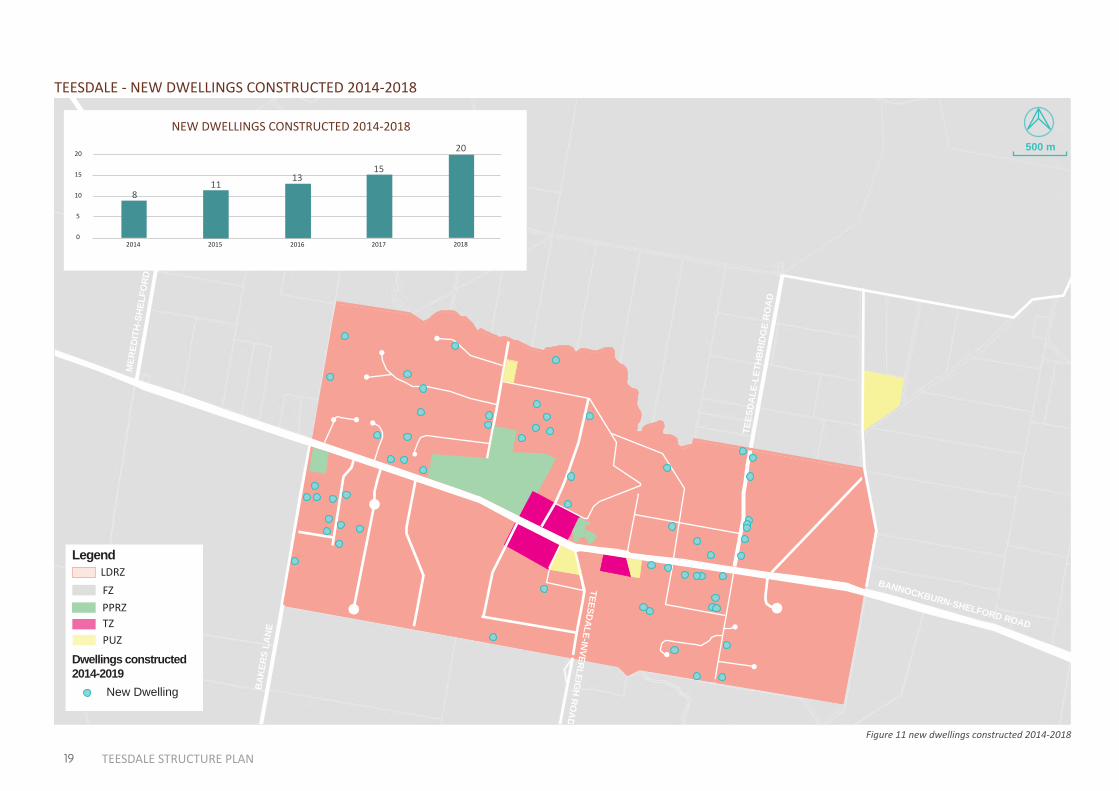
TEESDALE - NEW DWELLINGS CONSTRUCTED 2014-2018
20
15
10
5
02014 2015 2016 2017 2018
NEW DWELLINGS CONSTRUCTED 2014-2018
811
1315
20
Figure 11 new dwellings constructed 2014-2018
7
20 TEESDALE STRUCTURE PLAN
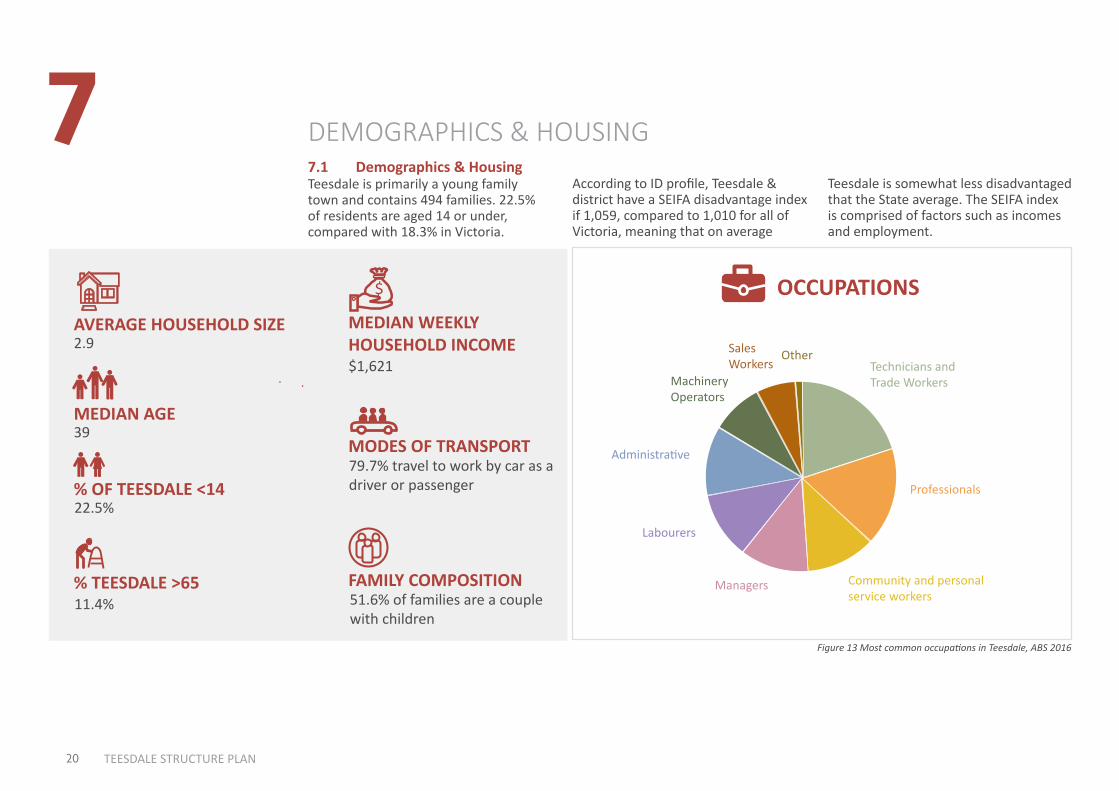
7.1 Demographics & Housing
DEMOGRAPHICS & HOUSING
Teesdale is primarily a young family town and contains 494 families. 22.5% of residents are aged 14 or under, compared with 18.3% in Victoria.
OCCUPATIONS
Managers
Labourers
Administrative
Machinery Operators
Sales Workers
OtherTechnicians and Trade Workers
Professionals
Community and personal service workers
Figure 13 Most common occupations in Teesdale, ABS 2016
According to ID profile, Teesdale & district have a SEIFA disadvantage index if 1,059, compared to 1,010 for all of Victoria, meaning that on average
MEDIAN WEEKLY HOUSEHOLD INCOME
MODES OF TRANSPORT
FAMILY COMPOSITION
AVERAGE HOUSEHOLD SIZE
MEDIAN AGE
% OF TEESDALE <14
% TEESDALE >65
79.7% travel to work by car as a driver or passenger
39
2.9
22.5%
$1,621
$
51.6% of families are a couple with children
11.4%
Teesdale is somewhat less disadvantaged that the State average. The SEIFA index is comprised of factors such as incomes and employment.
21 TEESDALE STRUCTURE PLAN
TrainBus
Tram or FerryTaxi
Car- as driverCar- as passenger
TruckMotorbike
BicycleWalked only
OtherWorked at home
Did not go to workNot stated
Method of travel to work, 2016Total employed persons
Teesdale and District
VictoriaM
etho
d us
ed
% of employed persons aged 15+
0 10 20 30 40 50 60 70 80
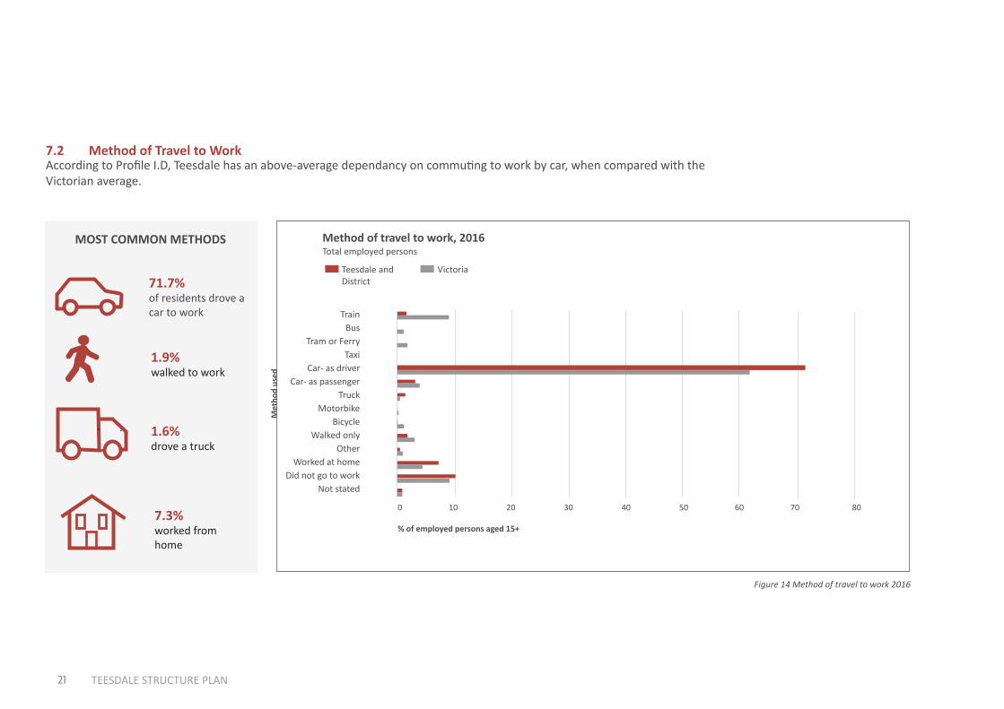
Figure 14 Method of travel to work 2016
71.7% of residents drove a car to work
1.9% walked to work
1.6% drove a truck
7.3%worked from home
MOST COMMON METHODS
7.2 Method of Travel to WorkAccording to Profile I.D, Teesdale has an above-average dependancy on commuting to work by car, when compared with the Victorian average.
8
22 TEESDALE STRUCTURE PLAN
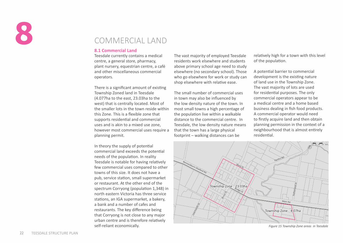
8.1 Commercial Land
COMMERCIAL LAND
The vast majority of employed Teesdale residents work elsewhere and students above primary school age need to study elsewhere (no secondary school). Those who go elsewhere for work or study can shop elsewhere with relative ease.
The small number of commercial uses in town may also be influenced by the low density nature of the town. In most small towns a high percentage of the population live within a walkable distance to the commercial centre. In Teesdale, the low density nature means that the town has a large physical footprint – walking distances can be
Teesdale currently contains a medical centre, a general store, pharmacy, plant nursery, equestrian centre, a café and other miscellaneous commercial operators.
There is a significant amount of existing Township Zoned land in Teesdale (4.077ha to the east, 23.03ha to the west) that is centrally located. Most of the smaller lots in the town reside within this Zone. This is a flexible zone that supports residential and commercial uses and is akin to a mixed use zone, however most commercial uses require a planning permit.
In theory the supply of potential commercial land exceeds the potential needs of the population. In reality Teesdale is notable for having relatively few commercial uses compared to other towns of this size. It does not have a pub, service station, small supermarket or restaurant. At the other end of the spectrum Corryong (population 1,348) in north eastern Victoria has three service stations, an IGA supermarket, a bakery, a bank and a number of cafes and restaurants. The key difference being that Corryong is not close to any major urban centre and is therefore relatively self-reliant economically.
About this Document: This map has been created for the purpose of showing basic locality information over Golden Plains Shire Council. Cadastral information has been provided by Land Victoria and may not accurately reflect true title status and/or boundary definition.
Disclaimer: This map is a representation of the information currently held by Golden Plains Shire Council. While every effort has been made to ensure the accuracy of the product, Council accepts no responsibility for any errors or omissions.0
Township Zone - 23.03ha
Township Zone - 4.07ha
Bridge St
Bannockburn-Shelford Rd
Main Rd
Lear
mon
th St
Ware St
Bruc
e St
Suth
erla
nd S
t
Pantics Rd
0 50 100 150 200m
Figure 15 Township Zone areas in Teesdale
relatively high for a town with this level of the population.
A potential barrier to commercial development is the existing nature of land use in the Township Zone. The vast majority of lots are used for residential purposes. The only commercial operators appear to be a medical centre and a home based business dealing in fish food products. A commercial operator would need to firstly acquire land and then obtain planning permission in the context of a neighbourhood that is almost entirely residential.
9
23 TEESDALE STRUCTURE PLAN
9.1 Community Infrastructure & Open Space
COMMUNITY INFRASTRUCTURE &OPEN SPACE
Teesdale currently contains: • A primary school.
• A Pre-school.
• Community hall.
• Presbyterian Church.
• Public Park (Turtle Bend Park) including play equipment.
• A football oval with pavilion (at Don Wallace Reserve).
• Don Wallace Reserve and Sheoak Nature Conservation Reserve.
• Several tennis courts.
• Several walking tracks, including along the main street and along a part of Native Hut Creek close to the centre of town.
• A BMX track.
• Chinaman’s Lagoon (a lagoon, walking area and bushland reserve).
Turtle Bend Park is currently planned for a substantial upgrade, following a successful $222,000 Federal Government grant application.
The park already contains a toilet, BBQ, shelter and play equipment.
Teesdale is a short drive to Bannockburn which contains higher order community infrastructure such as a library.
Pedestrian and Cycle NetworkTeesdale contains several walking tracks including along the entire main road and along a part of Native Hut Creek close to the centre of the town. There are additional walking opportunities at Don Wallace Reserve and around Chinaman’s Lagoon.
Other than the main road, Teesdale does not contain footpaths in residential streets. However newer subdivision standards require a footpath along at least one side of every road, even in low density areas.
The Golden Plains Paths and Trails Strategy identifies a number of future actions for Teesdale related to tracks and trails, including a shared path to Bannockburn.
INTERACTIONS WITH OTHERTOWNS & CITIES
24 TEESDALE STRUCTURE PLAN
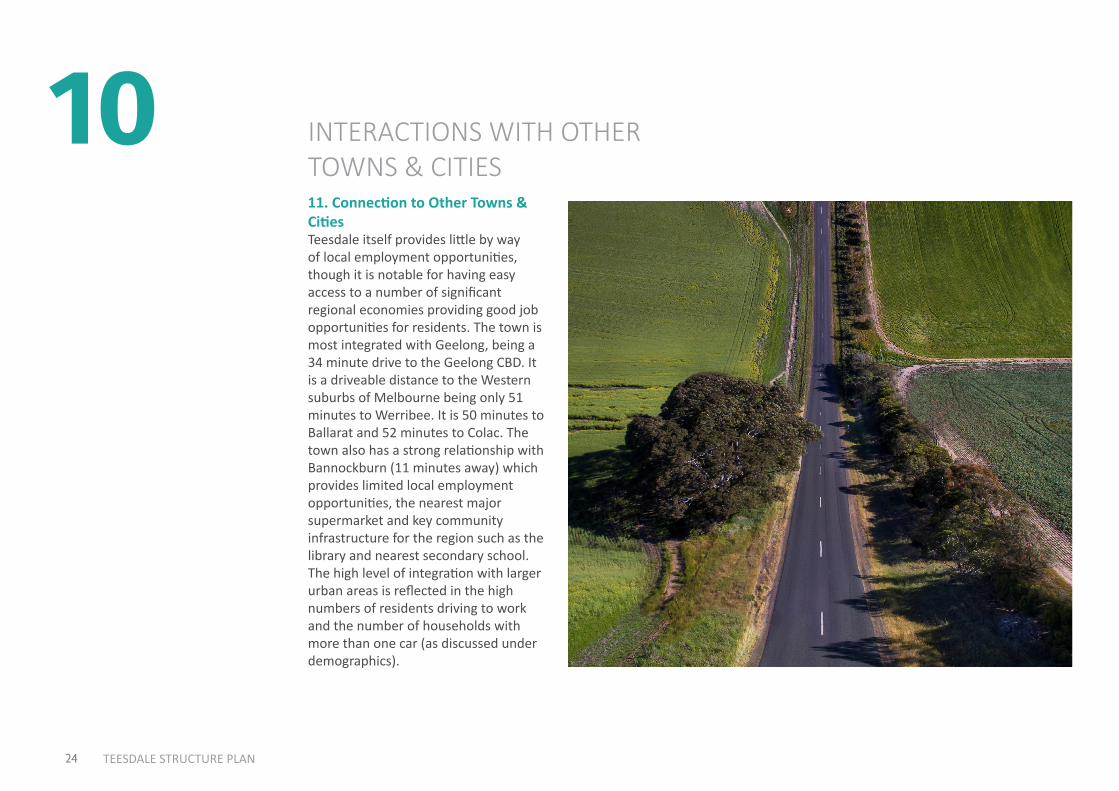
1011. Connection to Other Towns & CitiesTeesdale itself provides little by way of local employment opportunities, though it is notable for having easy access to a number of significant regional economies providing good job opportunities for residents. The town is most integrated with Geelong, being a 34 minute drive to the Geelong CBD. It is a driveable distance to the Western suburbs of Melbourne being only 51 minutes to Werribee. It is 50 minutes to Ballarat and 52 minutes to Colac. The town also has a strong relationship with Bannockburn (11 minutes away) which provides limited local employment opportunities, the nearest major supermarket and key community infrastructure for the region such as the library and nearest secondary school. The high level of integration with larger urban areas is reflected in the high numbers of residents driving to work and the number of households with more than one car (as discussed under demographics).
25 TEESDALE STRUCTURE PLAN
Shelford - Bannockburn Rd
Rokewood - Shelford Rd
Inverleigh - Shelford Rd
Inve
rleig
h -
Win
chel
sea
Rd
Steiglitz Rd
Geelong - Ballan Rd
Geelong - Bacchus M
arsh Rd
Corio -
Wau
rn P
onds R d
To Ballarat
ToMelbourne
To WesternRegion
To WesternRegion
ToQueenscliff
ToTorquay
Hamilton Hwy
Hamilton Hwy
Midland H
wy
Midland Hwy
Princes Hwy
Bellarine Hwy
Prince
s Fw
y
Princes Fwy
Surf
coas
t Hw
y
Shelford
Lethbridge
Bannockburn
Teesdale
Batesford
Lara
Geelong
Leopold
Moriac
Waurn Ponds
Winchelsea
Inverleigh
Avalon
26 July 2018
Regional Context Plan1:65000
0 1000 2000 3000 4000 m
1:130000at A1 at A3Level 2, 6 Riverside Quay Southbank, VIC 3006
t 9695 3025 e [email protected]
INVERLEIGH STRUCTURE PLANGolden Plains Shire Council0 1000 2000 3000 4000 m
Lethbridge
Teesdale
Shelford
Inverleigh
MoriacWinchelsea
Leopold
Lara
To Melbourne
Geelong
To Torquay
To Western Region
Hamilton Hwy
Inverleigh-Shelford Rd
Bannockburn-Shelford Rd
Rokewood -Shelford RdSteiglitz Rd
Geelong - Ballan Rd
Geelong - Bachus M
arsh Rd Princes F
wy
Prin
ces F
wy
Batesford
Bellarine Hwy
Waurn PondsPrinces Hwy
Surf
coas
t Hw
y
Midland Hw
y
Bannockburn
To Western Region
*In
verle
igh
Win
chel
sea
R d
Avalon Airport
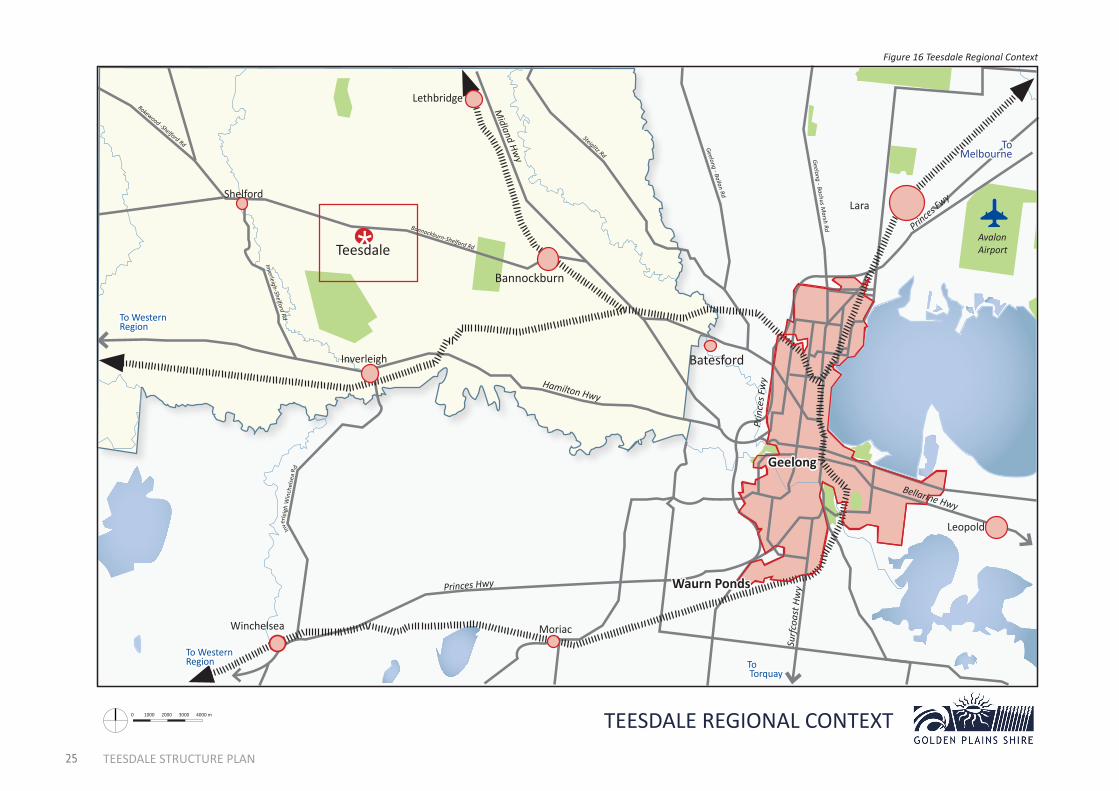
TEESDALE REGIONAL CONTEXT
Figure 16 Teesdale Regional Context

26 TEESDALE STRUCTURE PLAN
1110.1 Heritage
HERITAGETeesdale was part of the parish of Carrah and Burtwarrah, the county of Grant and the Shire of Leigh. The township of Teesdale on Native Creek was proclaimed in 1852 on a major travelling route to Buninyong via Mount Mercer. Like that settlement Teesdale was also connected to the pastoral concerns.
Teesdale’s first house in 1851 became the site of the post office. Aboriginal people used to camp in a paddock called Bullivant’s. It’s Farmer’s Common proclaimed in 1861, with a Mechanics’ Institute in 1874, which in 1888 became a free public library. A 1969 fire destroyed its hall, a new one built in 1973, at which time a water main was also constructed to connect the town to the Meredith basin. Teesdale was the site of the Leigh Community Centre in 1979.
There are six sites in Teesdale recognised and protected under the Heritage Overlay including the Presbyterian Church, the Teesdale primary school, a bluestone cottage “Gowan Brae”, the War Memorial, the Woolbrook Homestead Complex and Chinaman’s Lagoon.
A row of Maclura pomifera (Ossage Orange) and Pinus pinea (Stone Pine) on Bannockburn-Shelford Road, Teesdale are recognised by the Significant Landscape Overlay in the Golden Plains Planning Scheme. Both sets of trees date from the late 19th century, which is significantly longer than the typical life expectancy for these species.
Chinaman’s LagoonTeesdale’s original water supply was extracted from Native Hut Creek, but by the 1870s the water was considered too salty for human consumption and provisions were made to establish a permanent and more reliable water source for the emerging township. Earth works were undertaken to construct the reservoir at the site now known as “Chinaman’s Lagoon” and by 1883 tenders were called for the fabrication and laying of pipes and the construction of a tunnel. The Lagoon was named after the Chinese contractor who undertook works associated with the reservoir. In 1973 the town was connected to reticulated water from a basin at Meredith.
The site comprises an earthen dam and aboveground infrastructure, dating from the period when the water catchment supplied the township, including a bluestone lined well approximately .75 metres in diameter and a basalt paved offlet. The site includes significant amounts of bushland and native vegetation.
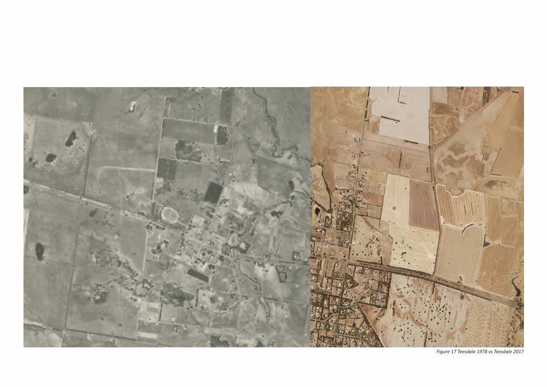
Teesdale 40 years agoAerial photography from the Department of Crown Lands Survey in 1978, as shown below, depicts Teesdale as a lightly populated area. Since this time the number of residential allotments has significantly increased.
About this Document: This map has been created for the purpose of showing basic locality information over Golden Plains Shire Council. Cadastral information has been provided by Land Victoria and may not accurately reflect true title status and/or boundary definition.
Disclaimer: This map is a representation of the information currently held by Golden Plains Shire Council. While every effort has been made to ensure the accuracy of the product, Council accepts no responsibility for any errors or omissions.0
Figure 17 Teesdale 1978 vs Teesdale 2017
12
28 TEESDALE STRUCTURE PLAN
12.1 Key Findings
KEY FINDINGS
Commercial Land• Teesdale lacks many business types
generally found in towns of this size such as a service station, pub or restaurant.
• While the centre of the town is zoned as the Township Zone and can support both residential and commercial development (generally requiring a planning permit), the vast majority of this land is used for residential purposes at the current time.
Residential Land• The supply of remaining greenfield
land available is sufficient to cater to around 13 years of population growth at a current growth rate of 2.5% per annum.
• Teesdale contains extensive potential for infill subdivision.
• If no further greenfield subdividable land is recommended by this iteration of the Teesdale Structure Plan, infill subdivisions are likely to occur to a greater extent than otherwise might be experienced in order to cater to demand.
Street Lights• Teesdale contains no street lights in
the older parts of town, including along the entire main road.
Street TreesTeesdale contains a mix of native and exotic street trees with no clear theme, however the street trees are generally aesthetically pleasing.
Crossings• There is one crossing in the town on
the main road in front of the school, suitable for crossing in School times with a supervisor. Teesdale does not have any other pedestrian crossings, including on the main road (a VicRoads road).
• There are no pedestrian refuge islands on the main road
Sewer• Teesdale is unsewered.
• Teesdale is growing and is close to the reticulated sewer network in Bannockburn.
• There are no current plans to sewer Teesdale in Barwon Water’s 5 year capital works program, however the circumstances of the town appear to warrant consideration for sewering over the long term.
• Whilst Council is unable to provide sewer, a community preference for sewer is likely to be of potential interest to Barwon Water if it exists.
• If reticulated sewer was ever installed it would bring opportunities, but would also change the character of the town. Most notably the Low Density Residential Zone applicable to most of the town has a minimum subdivision size of 2000 square metres for sewered lots and 4000 square metres for unsewered lots.
• Reticulated sewer would be at a cost to individual land owners, for instance the Smythesdale sewer scheme involved a cost of around $3000 - $6000 per lot. Land owners were also responsible for organising the decommissioning of their existing septic system.
Entrances to town• On approach from Bannockburn,
Teesdale does not contain an entrance feature or sign and could possibly be enhanced by a more consistent vegetation theme.

29 TEESDALE STRUCTURE PLAN
• On approach from Bannockburn, just before Teesdale-Lethbridge road on the right hand side of the road reserve there is a 150m long gravel area of unknown origin with some mounds of gravel. This is out of keeping with other parts of the road reserve, which are generally vegetated.
• On approach from the west side there is little to identify that one has entered a town, other than glimpses of houses – generally behind trees.
Flood Mapping• A flood mapping study is being
finalised by the CCMA, which when completed will result in modifications to the flood levels and the extent of existing mapping in the vicinity of native hut creek. A planning scheme amendment will be required to implement the mapping.
• A tributary of Native Hut Creek which goes through Chinaman’s Lagoon and across Jolly’s road has not been flood mapped, but is understood to warrant consideration for future flood mapping.
Note: Existing Council Strategies include plans for the upgrades to the path network, as well as upgrades at the Don Wallace Recreation Reserve, Turtle Bend Park, improvements to the Teesdale Hall and an upgrade to the Leighdale Equestrian Centre. These have not been listed as key issues, as they will not be relevant to the Structure Plan – which will seek to avoid duplication with existing plans and strategies.