lauderdale structure plan
TRANSCRIPT

Lauderdale Structure Plan
Clarence City Council 2011

Lauderdale Structure Plan 2
Contents
Executive Summary 3
1. Introduction 3 2. Aims 4 3. Elements
3.1. Urban Form (character) and Sustainability 4
3.2. Residential Land Use 6
3.3. Commercial Land Use 10
3.4. Recreation 14
3.5. Community Facilities and Services 15
3.6. Movement 16
3.7. Physical Services/ Water and Sewer and Stormwater Infrastructure 19
3.8. Climate Change 20
3.9. Natural Assets 21
3.10. Staging 22
4. Conclusion – The Structure Plan 23

Lauderdale Structure Plan 3
Executive Summary
This structure plan is a long term plan for the use and development of Lauderdale. It is specifically a spatial plan and deals with issues in a broad framework. It is not intended to provide the level of detail you would expect in a detailed urban design masterplan, a social plan, landscape plan or the like.
This plan provides a framework for actions, some of which may require further project work involving detailed investigation and design, before they can be implemented.
Broadly then this structure plan builds on several important reports and plans to provide a framework for the following key elements in the growth of Lauderdale:
• Expansion of the urban growth boundary and associated planning scheme modifications
• Provision for a neighbourhood activity centre with a large supermarket and associated specialty shops to serve the Lauderdale community and surrounding suburbs, from Acton Park to Opossum Bay
• Provision for expansion of the residential area along the main collector linking the South Arm Highway to Bayview Road
• Improved movement systems, including public transport, bicycles and pedestrian access, improved connections between commercial properties and to public land
• Enhanced streetscapes to provide a high standard of residential and commercial amenity.
• Climate change responses for public land, including managing beaches as well as supporting development controls to protect buildings from inundation and coastal erosion events in the future.
• Development coordinated with the supply and connection of reticulated services.
1. Introduction
What is a Structure plan?
In this case, a structure plan is a land use plan that sets out the future form of the study area. It recognises, at a broad scale, the location of residential, commercial and other land use types, the main road network, community services and facilities and takes into account the built and natural constraints to development.
Why a structure plan for Lauderdale?
Lauderdale’s residential boundaries of have been established for many years, with suburban densities focused along the north and south sides of Ralphs Bay Canal, and along Roches Beach, where the main streets are Balook, Bangalee and Terrinna streets, north of the canal and Bayview Road south of the canal.
There is also some commercial development on the South Arm Highway, opposite Ralphs Bay. This area includes an ad hoc arrangement of building forms and includes a hotel, various smaller shops, and a medical centre. There has also been recent interest in expanding the commercial area to provide for a range of shops offering more daily and weekly needs shopping, as well as motel accommodation. Another small grouping of local commercial premises lies south of the Lauderdale Canal, fronting the Highway.
Another important element in the Lauderdale community is the primary school at the corner of South Arm Highway and Acton Road, which offers nearly 600 places and has been subject recent extensive redevelopment.
The redevelopment of the Lauderdale football oval also promises to promote more sport at junior and senior levels, bringing with it greater visitation to Lauderdale.
The Lauderdale area has a poor history in relation to the safe disposal of household waste as it has been reliant on on‐site effluent disposal systems. It has long been planned to resolve this through the supply of a reticulated sewerage system and this is now coming to fruition through a staged program. Stage 1 has been completed, enabling the connection of Lauderdale Primary School and nearby commercial properties, while Stage 2 is underway and will service the majority of residential properties in Lauderdale.
While Lauderdale has grown over recent years largely through infill and redevelopment of existing properties, the surrounding areas have also grown with significant infill and growth in the Acton Park and Seven Mile Beach areas and south of Lauderdale, in Sandford, South Arm and Opossum Bay, as well as approvals for large subdivisions on the south and east sides of Rokeby. All this has places new demands on the social and physical infrastructure in Lauderdale.
The major constraints to growth include the physical boundaries, created by Ralphs Bay, Roches Beach as well as the South Arm Highway, which are not simply physical barriers but impose a range of current and future impacts influencing the use and development of the locality. The impacts of climate change will also become a more important constraint to the location and form of development as well as for the management of existing infrastructure and buildings.
The structure plan will therefore provide a mechanism to recognise the inter‐relationship of these and other physical components, providing a framework for:
• Planning for and influencing future growth
• Assisting in capital works and community service investments
• Influencing and informing planning scheme amendments.

Lauderdale Structure Plan 4
2. Aims
The Aims of the Structure Plan are to provide for the future development of the area in a way that:
• integrates use and development with the surrounding land.
• takes into account all physical constraints, including the future impacts of climate change on inundation and erosion.
• protects threatened species from incompatible use and development of land.
• enhances visual qualities of the locality and incorporates good urban design treatments.
• provides for greater choice in transport modes, with safe and efficient systems for vehicles, cycles and pedestrians.
• provides for commercial and community services and facilities commensurate with the needs of local and surrounding residents.
• provides for appropriate residential growth, including infill, redevelopment and limited expansion.
• ensures a diverse range of recreational opportunities can be encouraged and promoted.
• enables the development of a strong sense of place, encouraging the enhancement of public places.
• provides certainty for proposals and planning scheme amendments that are consistent with the structure plan.
• appropriately stages development, ensuring ad hoc development resulting in the inefficient supply of services and facilities is avoided.
• Takes into account the capacity of physical infrastructure.
The main driver for change to the urban form will be through public sector investment – especially in reticulated sewerage, in streetscaping, infrastructure improvement (roads, footpaths, cycle paths), in the development and maintenance of public open spaces and links and through the protection and enhancement of beaches and private land from the physical impacts of our changing climate.
It follows that this structure plan has a strong emphasis on the public realm. To achieve its aims, it prioritises improving the amenity of public places, the amenity of the beaches, the accessibility and safety of streets and access links, and promoting improved movement systems, including public transport and cycling.
The public realm is also significant in relation to the role of private commercial development, because of its typically prominent siting and its role in creating a community centre, it must also play an important part in developing the desired sense of place. Therefore the structure plan must also aim to achieve good development standards that are also aesthetically relevant to Lauderdale.
3. Elements
In this section, the elements of urban and physical form are examined and relevant Objectives and Strategies are set out. For consistency, they are structured as follows:
• Description ‐ contains an analysis of the element.
• Objectives ‐ specifies the aim of the Structure Plan in respect of this element.
• Actions – methods of implementing the Objectives.
• Priorities – identifies the relative importance of each Action and the timeframe for implementation. For convenience, these are identified as being of High, Medium or Low importance. This need not relate to the timing of implementation necessarily, but gives a perspective of their relative importance to the future development of Lauderdale. Hence, lower order items may be completed earlier as they may be inexpensive or easier to achieve, whereas High priority actions may take longer to achieve but are strategically more important to achieving the aims of the structure plan. Hence, the priorities may be interpreted as flows:
High – means the action is an important priority and is integral to desired change.
Medium – means the action is a medium term property but implementation is important to the amenity of Lauderdale.
Low – means the action will improve the amenity of Lauderdale and can be a longer term priority, where dependant on budgetary commitment.
Ongoing – means the action is one without a finite completion, so it may include a continuing practice once initially implemented.
• Design Principles – an outline of the guiding values that should direct the design of buildings and infrastructure.
3.1. Urban Form (character) and sustainability
• Description
The term urban form relates to the physical layout and design of the area including the three dimensional elements of buildings and natural elements such as the vegetation.
Lauderdale’s urban form is comprised of the elements described in the following section. However it is useful to overview the elements in terms of their interrelationships, to allow the setting of over‐aching Objectives and Actions.
So, in a general sense, Lauderdale’s urban form is characterised by:
- Low building height – one or two storeys, generally simple forms of domestic architecture – even commercial buildings offset their height with sprawling footprints.
- Primarily a residential community, with buildings often exhibiting a seaside, even holiday appearance and setting, without a homogeneous style.
- Separate built precincts – the two commercial areas fronting South Arm Highway; Bayview Road ‐ north; Bayview Road – south; Lauderdale canal housing and the central rural residential areas which run through from the South Arm Highway.
The key issues for Lauderdale involve providing for a sustainable urban area, where: - the supply of infrastructure and community services and facilities is efficient. - a desired urban character is identified and enhanced through building design, landscaping/ streetscaping
and movement systems.

Lauderdale Structure Plan 5
- entries to urban areas are well defined – especially at the main gateways along the South Arm Highway, where the activity centres in particular announce arrival at Lauderdale.
- unique environmental values that distinguish Lauderdale; Ralphs Bay, the Lauderdale Canal and Roches Beach.
• Objectives/ Actions
Objectives Actions Priorities/ Budget UF/O1 To ensure the urban growth boundary reflects the desired future form of Lauderdale.
UF/A1.1 Amending the planning scheme’s urban growth boundary to provide for the sustainable growth of Lauderdale.
High
UF/A1.1 Amending the planning scheme to provide for a Commercial Zone that allows for the growth of the Activity Centre and a Residential Zone to accommodate infill along Ringwood and Mannata Roads.
High
UF/O2 To improve the aesthetic of streetscapes
UF/A2.1 Undertaking a landscaping plan for the study area and implementing soft and hard landscape treatments, in particular applying a thematic approach to enhance the particular character of each precinct, taking into account traffic volume, road type/ role (through or truncated street), and physical constraints.
(plan requires initial budget commitment and rolling budget item for implementation)
UF/A2.2 Improving the quality of the built fabric by ensuring quality architectural approaches to public buildings and other structures.
Medium/ Ongoing
UF/A2.3 Promoting “neo‐traditional” principles to the design of infill housing and other buildings, to produce a more compact and connected Lauderdale
High/ Ongoing
UF/A2.4 Improving green spaces in the private and public realms, promoting community pride and identity through ownership and enjoyment of these spaces.
Medium/ Ongoing
UF/A2.5 Identifying the entry to Lauderdale with formal landscaping treatments and other techniques, including entry signage, to increase awareness of the character and attractions of Lauderdale.
Medium
UF/A2.6 Identifying the entrances to precincts within Lauderdale by using different landscape entrance themes
Low
UF/O3 To ensure the urban form encourages safe cycle and pedestrian movement
UF/A3.1 Ensuring community members are well connected through the design of the road and pathway networks, to avoid reliance on vehicles for intra‐Lauderdale trips.
High/ Ongoing
UF/A3.2 Retaining Lauderdale’s grid layout, avoiding infill subdivision with curvilinear streets and cul de sacs.
High
UF/A3.3 Implementing the Clarence Bicycle Strategy Action Plan and implementing traffic management devices to reduce vehicle speeds, especially in long straight sections of residential streets.
Medium/ Ongoing
UF/O4 To improve the appearance of Roches Beach for recreation and passive leisure activities
UF/A4.1 Implementing recommendations of the Climate Change study in relation to the protection and management of beaches and dunes.
High/ Ongoing
UFA/4.2 Restricting access points to beaches, to well designed, safe openings, combined with any appropriate facilities, such as car and trailer parking, toilets and waste collection.
High/ Ongoing
UFA/4.3 Protecting and reintroducing native vegetation along beachfronts and dunes.
Medium/ Ongoing
UF/O5 To provide for environmentally sustainable design principles in the design and construction of public places.
UF/A5.1 Using water sensitive urban design, use of durable materials and plants in hard and soft landscaping.
Medium/ Ongoing
UF/A5.2 Applying relevant “Crime Prevention Through Environmental Design” (CPTED) principles to streetscapes and activity centres and public spaces.
High/ Ongoing
UF/A5.3 Protecting important vegetation and habitat areas.
High/ Ongoing
• Design Principles The relevant design principles for developing Urban Form (character) and sustainability are: 1. The architecture of new buildings should enhance the appearance of the area; architecture should show
“good manners” to the setting, including any buildings and open spaces that make a good contribution to the amenity of the area.
2. Buildings should not be internally focused but interact with the street.
3. Settlement growth should avoid areas that will be subject to coastal erosion impacts from climate change.
4. The physical constraints of limited growth areas that may be subject to inundation, must be resolved before development is allowed. Any growth should be limited to infill along existing infrastructure and further expansion involving new roads, should be avoided. The remaining Rural Residential areas should be retained to maintain the character of the area and to avoid unnecessary exposure to climate change impacts on more closely developed buildings

Lauderdale Structure Plan 6
3.2. Residential Land Use
• Description
There are several distinct neighbourhoods in Lauderdale, the product of a combination of elements – distance, physical barriers, accessibility and location of shopping and community facilities.
The older areas developed along North and South Terrace and Bayview Road (the east‐west section) are original shack areas which are progressively being redeveloped. The same is true for the north/ south section of Bayview Road.
This form changes at the southern end of Bayview Road, where the subdivision bookended by Wateredge and Seamist Courts is an example of the Radburn style of urban design and feature a medium density set in established gardens with narrow streets.
Later and larger architecture occurs along the final section of Bayside Drive, south of Mays Point Road, where the land rises to give large and less densely developed housing spectacular views over Maydena Bay, Roches Beach, Lauderdale and beyond.
A different style again exists north of North Terrace, with development running along Terrina, Bangalee and Balook Streets. Appearing as the typical beachside suburban development with a range of single and 2 storey housing, there are many buildings of the 1960s and 70s as well as infill and replacement stocks comprising modern styled houses. This area is functionally separated from the southern parts of the village, south of North Terrace.
The key issues for residential amenity concern maintaining/ improving connectivity within neighbourhoods and to activity centres; retaining valued amenities, like access to the beaches; protecting environmental values; effluent odour control and effective wastewater disposal; promoting good infill architecture, which respects the urban character and amenities; and the amenity of neighbours, such as water access, view‐lines and the like.
The relationship of housing to the neighbourhood and the streetscape can also be addressed, particularly in the long straight streets. Encouraging gardens to spill out on to nature strips can improve the visual pleasantness in these areas, promoting neighbourhood character and identity, amongst other benefits. Good examples of this exist in Balook Street, where the image below shows landscaping improving the streetscape, introducing colour, interest and helping to create a lower speed environment.
The Clarence Residential Strategy Final Report 2008 is reflected in the current urban growth boundary for Lauderdale. The key findings of the strategy included identification of land supply for residential areas representing certain market segments. For Lauderdale, the report recognised:
• There was no more un‐subdivided urban zoned and reserved residential land and the only way to create additional sites in these areas would be to subdivide existing sites (e.g. residential land that already contains a house or that is vacant and of sufficient size to split into one or more lots). Several areas have no land available to be rezoned for residential purposes, whilst those that do have significant environmental or servicing constraints. (Connell Wagner ’08, 12)
• The smaller coastal and inland settlement areas including Lauderdale, have some demand for further growth, reflecting sea‐change and other lifestyle phenomena, but all of these areas are constrained by servicing, locational and environmental issues. Generally they should only be able to be developed within existing defined and zoned areas. It noted that for this segment, Cambridge has some potential for further limited development, however further investigation is required, including a structure plan (Connell Wagner ’08, 36). As this observation was made without the benefit of more recent investigation

Lauderdale Structure Plan 7
into Lauderdale, it is considered that the same reasoning can now be applied to the growth of Lauderdale.
Subsequent to the above Strategy, further analysis of the Lauderdale area has recognised the key physical constraints associated with climate change and how to respond to these through planning controls on the location and design of buildings; reticulated sewerage is now being provided, to overcome the problems of failing on‐site systems; and stormwater drainage constraints are understood in terms of their limitations to development. Also, updating of population growth and demand/ supply statistics for housing has been completed and demonstrates the existence of some unsatisfied demand in Lauderdale for this particular market segment. Ringwood and Mannata Roads have good potential for residential development, considering that:
• These are already busy local collectors, suitable for additional traffic and safe entry/ exit. Importantly, as the roads exist, there is no need for the construction of new roads or major engineering works associated with road construction.
• The abutting lots contain residential development (albeit low‐density) and significantly a large medium density retirement village on the south corner of the intersection of both roads. This level of development creates a residential amenity and therefore provides a sound basis for infill between the established urban areas around Bangalee Street and the South Arm Highway.
• Like the bulk of Lauderdale, there are physical constraints. However, the key issue of future inundation potential can be overcome through engineering design in this area. There are no other limiting natural constraints, such as native vegetation or habitat. This is not necessarily the case for other Greenfields situations, where new growth represents an unnecessary risk to property and any new infrastructure.
• The capacity of the storm water drainage system does place significant limitations on the number of housing opportunities, without some major upgrading.
• Objectives/ Actions
Objectives Actions Priorities/ Budget R/O1 To provide for the sustainable expansion of residential development by growth and infill
R/A1.1 Amending the planning scheme to provide for adequate land suitable for residential growth, including modifications to the urban growth boundary.
High
R/A1.2 Planning for urban growth along local collector roads (including Ringwood and Mannata roads), where supported by availability of a reticulated sewer.
High
R/A1.3 Ensuring the limited growth areas are developed to meet the climate change study standards for protection from inundation.
High
R/A1.4 Promoting “neo‐traditional” principles to the design of residential areas, producing a compact form, which is connects neighbourhoods in a way that is legible and easily permeable
High/ Ongoing
R/O2 To ensure a range of housing types are available to meet complex and changing housing requirements of the community.
R/A2.1 Promoting medium density development, where consistent with the residential amenity of the locality; avoiding encroachment into undeveloped areas that provide the open spaces between established urban areas.
Medium
R/A2.2 Promoting “affordable housing”, to allow for a greater range of housing types and sizes.
Medium/ Ongoing
R/A2.3 Allowing the recognised, but well connected, neighbourhoods to develop on the basis of their particular physical characteristics to be included in the proposed new planning scheme, as well as through the treatment of public spaces, such as the approach to streetscaping.
Low
R/A2.4 Allowing for private gardens to spill out onto nature strips abutting roads, to improve residential amenity, by breaking up and softening long streetscapes, improving residential amenity and safety, while providing a unique character to neighbourhoods and adequate pedestrian pathways relevant to the role of the street.
High
R/O3 To ensure that growth is supported by appropriate physical infrastructure.
R/A3.1 Ensuring reticulated services are provided to residential development.
High
R/A3.2 Ensuring roads are maintained in accordance with Council policy.
High
Lauderdale Structure Plan 8
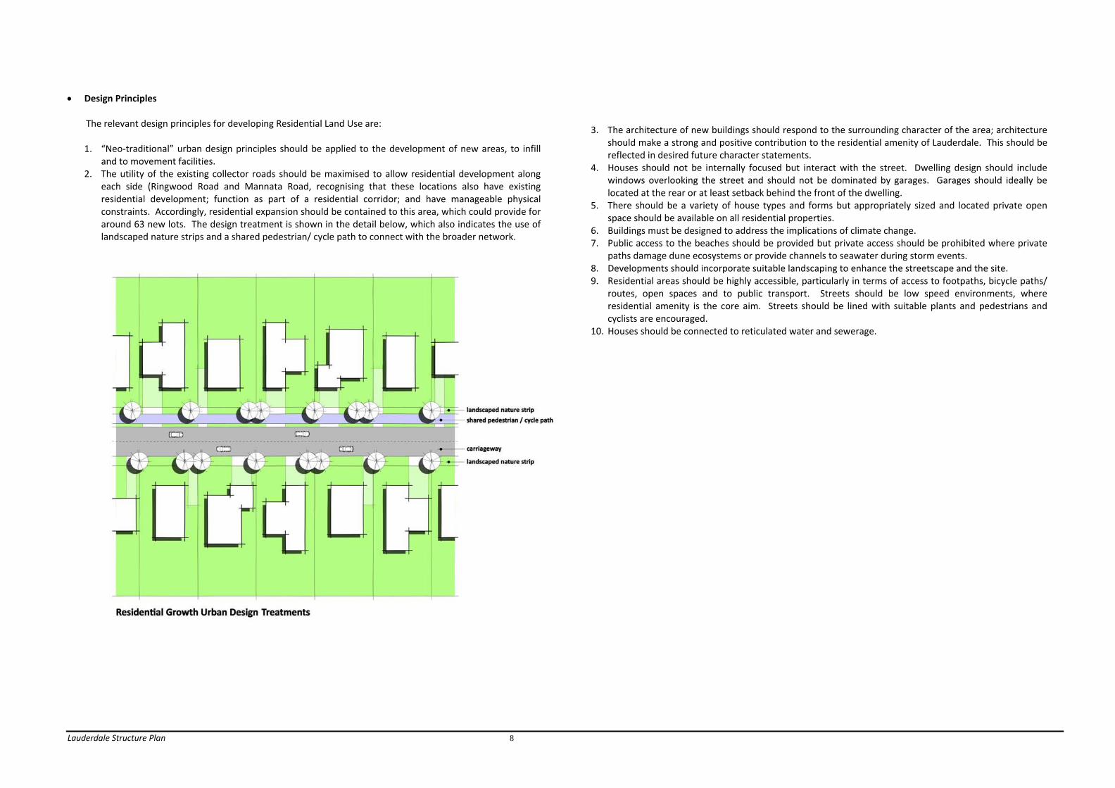
• Design Principles
The relevant design principles for developing Residential Land Use are: 1. “Neo‐traditional” urban design principles should be applied to the development of new areas, to infill
and to movement facilities. 2. The utility of the existing collector roads should be maximised to allow residential development along
each side (Ringwood Road and Mannata Road, recognising that these locations also have existing residential development; function as part of a residential corridor; and have manageable physical constraints. Accordingly, residential expansion should be contained to this area, which could provide for around 63 new lots. The design treatment is shown in the detail below, which also indicates the use of landscaped nature strips and a shared pedestrian/ cycle path to connect with the broader network.
3. The architecture of new buildings should respond to the surrounding character of the area; architecture should make a strong and positive contribution to the residential amenity of Lauderdale. This should be reflected in desired future character statements.
4. Houses should not be internally focused but interact with the street. Dwelling design should include windows overlooking the street and should not be dominated by garages. Garages should ideally be located at the rear or at least setback behind the front of the dwelling.
5. There should be a variety of house types and forms but appropriately sized and located private open space should be available on all residential properties.
6. Buildings must be designed to address the implications of climate change. 7. Public access to the beaches should be provided but private access should be prohibited where private
paths damage dune ecosystems or provide channels to seawater during storm events. 8. Developments should incorporate suitable landscaping to enhance the streetscape and the site. 9. Residential areas should be highly accessible, particularly in terms of access to footpaths, bicycle paths/
routes, open spaces and to public transport. Streets should be low speed environments, where residential amenity is the core aim. Streets should be lined with suitable plants and pedestrians and cyclists are encouraged.
10. Houses should be connected to reticulated water and sewerage.

Lauderdale Structure Plan 9

Lauderdale Structure Plan 10
3.3. Commercial Land Use • Description
Lauderdale has been recommended as the site for an expanded commercial centre, by the Clarence Activity Centre Strategy 2010 (Macroplan et al). The Strategy recognises the need for a centre to perform the role of a “Southern Clarence Neighbourhood Activity Centre” with around 7,000m2 of floor space.
The need for this expansion arises from the demand within Lauderdale’s catchment but the advantages are that in addition to providing a much needed service, this location will not adversely affect the regional retail hierarchy; will not affect the reasonable trading of the nearest centre, Shoreline (Howrah), and will make use of land which is currently available for commercial development.
Anticipated commercial growth should include a neighbourhood supermarket, specialty shops and community services, which will add to the existing stock of commercial functions and provide a level of service currently not provided to Lauderdale and the residents of the South Arm peninsula, Acton Park and estern Rokeby/ Oakdowns.
The existing centre has significant scope for further development, with ample vacant land in the area. Currently it is dominated by the Lauderdale hotel, which is physically bold and will help to create a particular identity for the future Lauderdale neighbourhood activity centre.
Adjacent commercial development is low rise and utilitarian in design. It does not make a strong positive contribution to the identity of Lauderdale, however it offers much scope for enhancement when the economic conditions and the owner’s interests combine to justify upgrading.
Both the hotel and the abutting shopping complex car parking dominate the streetscape. The expanses of car hard standing, with buildings set well back from the road accentuates the low plot ratio and density of the development, but also does nothing to enhance the streetscape, which could be redressed through landscaping, quality signage or other techniques. The common side boundary fence precludes any internal connection between the car parking areas, so that the need to drive between the properties via the South
Arm Highway, can be avoided. This is a poor element in terms of traffic safety and discourages integration of the activity centre.
The most suitable site for growth must be selected. The feasible options include building onto the existing local business zoned land, south of the Ringwood Road intersection or to expand the commercial area to include the land on the north side of the intersection. The existing land has been available for development for some years but there is little evidence of interest in undertaking large commercial development there and to some extent the location of existing buildings on site is an impediment to redevelopment. Conversely, there has been interest in the land on the north side of Ringwood Road. It’s suitability for development is also enhanced by its ability to utilise Ringwood Road for access and egress and to avoid traffic conflict with movement on the South Arm Highway. It also now benefits from access to reticulated sewerage. From an urban design standpoint, it also has the advantage of its gateway location to enable it to frame the entry to Lauderdale, with a bold statement.
The neighbourhood shopping centre south of the Bangalee Street and Mannata Road intersection provides typical daily shopping needs. It is anticipated that this will continue to provide for those needs, however when the opportunity arises, updating the appearance of the buildings will improve their function and their relationship with the streetscape. There are also several businesses dispersed into residential areas, which add to diversity and can create interest as well as needed services to the local community. However it is important that their architecture is domestic in scale and continues to enhance the surroundings.
The key issues involve: - The need to upgrade the activity centre to provide the level of services demanded by the surrounding
localities. - The need to ensure that commercial expansion produces high quality urban design that enhances the
gateway into Lauderdale and integrates commercial properties to produce a superior level of convenience to shoppers and service providers alike.
- The need to ensure the appearance of neighbourhood shopping and mixed use sites is improved in terms of their visual relationship with the streetscape. Examples of both opportunity and good integration are shown in the images below.

Lauderdale Structure Plan 11
• Objectives/ Actions
Objectives Actions Priorities/ Budget C/O1 To provide for the expansion of commercial floor space to serve the needs of the service area, including Lauderdale and suburbs to the north, north east and south.
C/A1.1 Consolidating the commercial area along South Arm Highway, developing a core around the Ringwood Road area. In this regard, the land on the north side of the intersection must be treated as a key redevelopment site.
High
C/A1.2 Amending the planning scheme to provide for adequate land suitable for commercial developments, including modifications to the urban growth boundary.
High
C/A1.3 Ensure adequate land is available for the development of a supermarket of approximately 3,500m2 floor area, specialty stores and as well as neighbourhood services, such as medical, veterinary and local convenience.
High
C/A1.4 Encouraging the provision of a mix of businesses to suit the needs of the service area residents and visitors attracted by local events.
Medium
C/A1.5 Ensuring that the elements of the commercial area are linked to provide for a consolidated centre with convenient access to all businesses and facilities.
Medium
C/A1.6 Ensuring adequate and timely connection of new businesses to reticulated services.
High
C/O2 To ensure the design of commercial areas provide a contemporary approach to personal safety and amenity – defining, developing and promoting the character of the commercial centre.
C/A2.1 Ensuring commercial developments are easily accessible by vehicles and pedestrians as well as public transport.
High/ Ongoing
C/A2.2 Addressing the interface with different land uses, through landscaping, locating car parking areas away from conflicting uses, the use of building materials, colours and scales to achieve compatible physical relationships.
High/ Ongoing
C/A2.3 Upgrading Ringwood Road and the connection with South Arm Highway, to facilitate safe and appropriate access to abutting commercial properties.
Medium
C/A2.4 Requiring consolidated car parking areas within the commercial core, including providing for the flow through of traffic between car parks on abutting commercial properties.
High
C/O3 To ensure that the key commercial areas provide a strong and attractive statement at the gateways to Lauderdale.
C/A3.1 Developing a uniquely Lauderdale design code, to provide guidelines for commercial development to achieve a good quality approach to commercial building design and presentation. The urban design approach of the code should provide for:
• Maximising views from the commercial area over Ralphs Bay, building on the coastal character of the locality. • Creating an image that builds on the environmental and recreational qualities of Ralphs Bay. • Integrated car parking, access and associated landscaping and signage.
This may involve a planning scheme amendment to give weight to the code.
High
C/A3.2 Ensuring a consistent standard of signage, which is relevant to the scale and surrounding amenity to the commercial area (signage should be controlled through the urban design code, to ensure the desired quality).
High
C/A3.3 Developing a system of unique entry signage, to increase awareness of the character and attractions of the Lauderdale commercial areas.
High
C/O4 To ensure that mixed uses, including freestanding businesses within residential area, provide for local needs and enhance the amenity of those locations.
C/A4.1 Ensuring that developments in residential neighbourhoods make a positive contribution to the residential amenity of the areas, through compatible scale, design, colours, signage and the treatment of hard standing areas, especially with relevant landscaping.
Medium/ Ongoing

Lauderdale Structure Plan 12
• Design Principles
1. The architecture of new buildings should respond to the surrounding character of the area; architecture should make a strong and positive contribution to the urban amenity of Lauderdale.
2. Buildings must not be internally focused but interact with the street. 3. South Arm Highway commercial areas should adopt a uniquely Lauderdale design theme. (An
architectural character assessment is required to establish the desired theme). Relevant public art should be encouraged as part of this approach and can be achieved through planning controls addressing design and development standards. These design guidelines should address a thematic approach to development; building form; materials and colours; signage, car parking area design; land scaping principles; and the like.
4. Mixed uses should be designed to enhance the streetscape, with building treatments supportive of any adjacent residential character, through scale, form, materials, signage techniques and landscaping – whist recognising their fundamental commercial purpose.
5. Developments should incorporate suitable landscaping to enhance the streetscape and the site. 6. Developments should be highly accessible, particularly in terms of connection to shared pathways and
should have adequate and safe on‐site car parking and loading bays. 7. Buildings must be connected to reticulated services and a properly designed stormwater disposal
system. 8. Buildings must meet planning controls designed to address the implications of climate change. 9. The Ringwood Road entrance and threshold to entering the residential area should both be treated as
part of this overall design approach (described in Section 3.6 – Movement)

Lauderdale Structure Plan 13

Lauderdale Structure Plan 14
3.4. Recreation
• Description
The Lauderdale Football Oval at the south end of Lauderdale and the Rosscommon Equestrian Centre at the northern end of Lauderdale both provide for organised sport from local to State‐wide competition and so are important attractors.
Activities at the Lauderdale football oval in particular have implications for future traffic growth and providing support to nearby local businesses, since the complex is expanding to cater for more football and related activities.
Both these significant activities are important to the Lauderdale area and their growth is supported. However, there are some gaps in the provision sporting facilities in Clarence, which could be filled on available land in Lauderdale.
Archery is also well accommodated in Rosscommon, via Beach Road.
On the eastern side of Lauderdale, Roches Beach is also a significant recreational resource for local residents and visitors. Its expansive sandy beach and coastal views make it a very desirable area for water activities such as swimming, surfing and fishing, as well as beachcombing.
Ralphs Bay is contains a complex ecosystem and part of it was previously the proposed site of the now rejected Ralphs Bay residential canal development. The outcome says much about the community
expectations for this area. However it remains an important recreational area for water based activities. In fact it is a preferred area for wind surfers and some infrastructure has been provided to assist them with parking and water access nearby.
Public open spaces are important because they add to the character and amenity of the surrounding neighbourhood. They provide essential access to areas of quiet relaxation and enjoyment of the open air, of views – including those of the coast and Ralphs Bay.
The Structure Plan should recognise the value of active and passive recreation areas to Lauderdale and should provide them with relevant connections, using linear reserves and shared pathway links.
The key issues concern the need to provide for a suitable range of recreational facilities for local and regional needs. In particular, the ongoing development of the Lauderdale Football Oval should provide high quality facilities for local to state‐wide football. In time, it should also fill gaps in facilities for other team sports, like netball and soccer. Whilst Lauderdale residents are fortunate to live in an area with many natural advantages that they can enjoy, a key issue will also be to ensure that pocket parks and open space links provide the range of experiences expected in a residential area and that they are safely and attractively maintained. However, there are a number of active and passive open spaces that are well used but need regular maintenance or upgrading. This includes the well designed skate park, as well as beachside pocket parks.
• Objectives/ Actions
Objectives Actions Priorities/ Budget Rec/O1 To identify opportunities for new open spaces to meet the needs of the community.
Rec/A1.1 Developing a new public open space policy for Clarence, to direct the application of public open space contributions from subdivisions. This policy should take into account the need for a variety of recreational needs, (including pocket parks, linear reserves), the age characteristics of the neighbourhood, the appropriate level of service requirement, land suitability and it’s proximity to allied activities, such as community facilities.
Medium
Rec/A1.2 Providing pocket parks where required to serve neighbourhood precincts, in accordance with the public open space policy. Consideration should be given to maintenance in the design and future management of these spaces, using low maintenance plants and structures for example.
Medium
Rec/A1.3 Developing linear parks and safe accessways to connect open spaces, recreational facilities and activity areas.
Medium
Rec/A1.4 Ensuring planning controls do not preclude the use of Roches Beach or Ralphs Bay for sporting activities associated with enjoying the beach or water.
Medium
Rec/O2 To encourage the active use of regional facilities that promote Lauderdale as a sporting destination.
Rec/A2.1 Providing for the growth of Lauderdale Oval, including participant and spectator facilities (car parking, seating, training, administration rooms and the like) and expanded facilities for additional team sports to serve the wider Clarence community.
High
Rec/A2.2 Providing for the continued development of the Rosscommon equestrian area, including the staging of a range of equestrian events of broad community interest, including development of relevant buildings, car parking and other facilities.
Low
Rec/O3 To provide suitable recreation spaces for a wide range of passive and active pursuits.
Rec/A3.1 Ensuring existing open spaces are maintained and improved and where possible connected by movement links. For example, the skate park should be connected to upgraded links on either side of the Lauderdale Canal.
Medium
Rec/A3.2 Encouraging Lauderdale Primary School to make its facilities available for use by community groups, particularly recreation and meeting facilities.
Medium
Rec/O4 To provide for suitable and safe public access to beaches
Rec/A4.1 Improving and maintaining linkages between public open spaces.
Medium
Rec/A4.2 Closing unapproved paths from private properties to beaches, especially where these impact on revegetation or where they conflict with protection of property from sea level rise.
High
Rec/A4.3 Developing and maintaining safe community facilities at the approved access areas, including where appropriate, sealed areas for car and boat trailer parking, toilets and wash down areas, landscaping and picnic facilities, in the reserves already set aside.
Medium

Lauderdale Structure Plan 15
• Design Principles
1. The architecture of new buildings in recreation reserves areas should respond to the surrounding character of the area; architecture should make a positive contribution to the visual amenity of Lauderdale.
2. Relevant public art should be incorporated into recreational areas, to improve the amenity of Lauderdale generally and specifically to enhance the experience of Council’s open spaces and facilities.
3. Open space reserves should incorporate suitable landscaping to enhance the site and it’s enjoyment by the public.
4. Open spaces and recreational facilities should be very accessible, particularly in terms of connection to shared pathways. They should have adequate and safe on‐site car parking, especially where team sport is played.
5. Facilities should reasonably protect public safety, even though there will always be a level of risk for some activities.
6. Open spaces should be supported by appropriate parking, where applicable to the use of the beach, parking for boat trailers and amenities such as barbeques and toilets should be considered.
7. Recreation spaces should be designed to fit with Council’s management regime, to ensure good standards are maintained for as long as possible. In passive spaces, low maintenance plants should be used, for example.
3.5. Community Facilities and Services
• Description
There are a number of community facilities provided within Lauderdale. The Lauderdale hall on South Terrace is an important community resource. However there is wide range of services provided to Lauderdale residents, from child and infant welfare and other infant activities through to a range of services for the elderly. These facilities are important for an established community that is home to the full range of household types. In turn this provides for diversity as well as a broad range in the demand for services, facilities, commercial and employment opportunities.
Educational facilities are also an important part of Lauderdale’s community infrastructure. The Lauderdale Primary School is well attended and continues to develop. Recent investment has involved the expansion of school buildings to include a large auditorium. A child care centre is also under construction on the adjoining property, establishing this firmly as an educational core for the community. In time, the use of school facilities such as the new auditorium for community purposes such as meetings, would be a great advantage to local people.
The key issues include identifying and meeting community needs for community facilities and to ensure they are well located, serviced and offer a high level of amenity, to reflect well on Clarence and in particular, the lifestyle advantages of the Lauderdale area.
• Objectives/ Actions
Objectives Actions Priorities/ Budget CF/O1 To ensure that public places are safe
CF/A1.1 Ensuring public places are well lit.
Medium
CF/A1.2 Using CPTED design principles when developing or redeveloping public places.
High
CF/O2 To provide for local education services
CF/A2.1 Ensuring there is adequate provision for the ongoing development of Lauderdale Primary School.
Low
CF/A2.2 Providing for needed child care and early learning facilities, especially in close proximity to residential neighbourhoods and where relevant links exist, to Lauderdale Primary School.
Low
CF/O3 To ensure that there is a wide range of facilities and services for all life stages needing support in the community.
CF/A3.1 Providing for the ongoing support of community meeting and recreational halls in Lauderdale and working with the community to identify what new facilities and services are required.
High
CF/A3.2 Supporting the retention and enhancement of existing community buildings and facilities to provide for community interaction and wellbeing.
Medium
CF/A3.3 Ensuring there are opportunities to provide a high level and range of health services to meet the needs of the local and wider communities for whom Lauderdale is the most practical focal point for these services.
Low
CF/O4 To ensure that buildings used for community facilities are enjoyed by users and make strong contribution to the streetscape.
CF/A4.1 Ensuring that buildings are designed to enhance the streetscape, by applying architectural standards relevant to the streetscape.
Low
CF/A4.2 Identifying opportunities for providing public art that improves the sense of place, local identity and community perception.
Low

Lauderdale Structure Plan 16
• Design Principles
1. The architecture of new buildings and prominent additions should respond to the surrounding character of the area; architecture should make a strong and positive contribution to the amenity of Lauderdale. In this sense, a uniquely Lauderdale design theme should be followed. (An architectural character assessment is required to establish the desired theme).
2. Developments should incorporate suitable landscaping to enhance the site and it’s enjoyment by the public.
3. Developments should be highly accessible, particularly in terms of connection to shared pathways and should have adequate and safe on‐site car parking and where appropriate, bus drop off/ pick up spaces.
4. Relevant public art should be incorporated into sites, to improve the amenity of experience of community facilities.
5. Designs should wherever possible, provide for multiple or alternative uses by different community groups. Buildings will therefore be adaptable to changing community needs.
3.6. Movement
• Description
Lauderdale is largely a grid layout comprising 3 linear sections, focused on Ralphs Bay (South Arm Highway), Ralphs Bay Canal, Bayview Drive and Roches Beach.
The South Arm Highway provides excellent access to and past Lauderdale, for vehicles, pedestrian and cyclists. However, it is important to ensure the safety of the Highway for all users in the event that the additional traffic associated with the commercial area and the school in particular, increase the movements around key intersections.
The grid providing internal access to the Roches Beach residential areas also provides efficient and safe access. This provides a sound base for maintaining and improving a “neo‐traditional” approach to urban design, with consequent benefits to the Lauderdale community, in terms of easy access to community facilities and activity areas and other intra‐Lauderdale trips.
Pedestrian and cycle access is also generally safe and easy going, due to the flat terrain (excluding the south end of Bayview Drive area). However the sprawling nature of the linear Roches Beach development makes trips from the northern end to the commercial area or the sporting areas, relatively long.
The key issues concern the need to provide for a safe, equitable and efficient movement system, with particular emphasis on improving the networks for cyclists and pedestrians moving around within Lauderdale. This involves implementing the Clarence Bicycle Strategy Action Plan, ensuring appropriate access in residential streets, traffic calming techniques and encouraging public transport. Indeed, these become more important given the prospect of an ageing population. This plan also identifies a number of objectives and strategies that are relevant to Lauderdale and its spatial connections. It confirms routes and identifies future project priorities. An existing shared bike/ pedestrian path is shown within the South Arm Highway. This connects to a proposed shared path to Terinna Street, where an existing shared path runs through Beach Road on the north side of Lauderdale.
The South Arm Road section is to become part of a “Principal Bike Route” and is identified running along the South Arm Highway through Lauderdale connecting to the City, via Rokeby, Howrah, Bellerive and Rosny Park. Acknowledged “Bike Routes” are identified along North Terrace and Bangalee Street; along South Terrace and Bayview Road; and connection of South Arm Highway to Bangalee Street via Mannata Street and Ringwood Road. Finally, a proposed shared path is proposed along the north side of the Lauderdale canal, connecting the Highway to Roches Beach.
Clarence also has a significant network of developed and informal tracks and trails, some of which pass through or bound Lauderdale. The Tracks and Trails Action Plan is plan is the Councils framework for providing an integrated network of tracks and trails through bushland and along the coastline.
The plan contains a number of strategies and key issues that are to be addressed by the strategic implementation of a range of tracks and trails in the City. For the Lauderdale study area, these include:
• Foreshore trails – Droughty Point to Lauderdale; Lauderdale to Dorans Road; Seven Mile Beach to Lauderdale; and Lauderdale to Cremorne; • Parks – Lauderdale Canal Park; and Bayview Park. Relevant to the future development of Lauderdale, the plan includes guidelines for including shared paths in new roads, where applicable and guidelines for track design.

Lauderdale Structure Plan 17
• Objectives/ Actions
Objectives Actions Priorities/ Budget M/A1.1 Upgrading Ringwood Road to facilitate safe and appropriate access to abutting commercial properties. This should involve headworks contributions from commercial developers benefitting from the works.
High
M/A1.2 Liaising with DIER to promote the desired landscape treatment along the South Arm Highway.
Medium
M/A1.3 Negotiating with DIER to develop upgraded intersections with the South Arm Highway, commensurate with safety requirements and to improve the visual contribution of the Highway, as a gateway avenue abutting whose setting presents special challenges and opportunities.
Medium
M/O1 To ensure that traffic management provides safe and efficient vehicular access to main roads and commercial and community facilities.
M/A1.4 Providing for a paved threshold on Ringwood Road, separating the commercial and residential areas. This will signify to drivers that they are leaving a commercial area and are entering a residential area with different traffic and amenity conditions.
High
M/O2 To ensure that public transport is efficient and accessible.
M/A2.1 Supporting initiatives of metro to improve services within Lauderdale, including communicating regularly with Metro to promote opportunities to provide ongoing improvements to the public.
Medium
M/A2.2 Encouraging the provision and maintenance of suitable bus shelters.
Low
M/O3 To ensure safe vehicle movement in residential areas and to ensure traffic does not adversely effect the amenity of those areas.
M/A3.1 Introducing traffic calming to slow traffic and improve safety for pedestrians and cyclists, in: • North Terrace • South Terrace • Balook Street; and • Bangalee Street These may take the form of roadside landscaping, reduced carriageway widths at certain points, paving treatments, however devices like humps should be avoided.
Medium
M/A4.1 Implementing the Clarence Bicycle Strategy Action Plan
Medium
M/A4.2 Providing secure bicycle racks and changing facilities at destination points within Lauderdale, on Council land and commercial properties.
Low
M/A4.3 Implementing the Tracks and Trails Action Plan.
Medium
M/A4.4 Ensuring high quality connections to open spaces, beaches and the commercial centre.
Low
M/O4 To improve safe pedestrian and cycle connections within Lauderdale and to nearby places of interest.
M/A4.5 Providing cycle lanes in: • South Arm Road • Acton Road • North Terrace • South Terrace • Balook Street; and • Bangalee Street
Medium
M/A4.5 Ensuring that footpaths are maintained in accordance with Council policy and relevant standards, to ensure safe and equitable access for footpath users.
High
• Design Principles 1. Road design must comply with Council’s Highways by‐law. 2. Cycle lanes must be provided to comply with the Clarence Bicycle Strategy Action Plan. These will be
separate lanes or marked on road lanes in accordance with the applicable Australian Standard.
3. Tracks and trails must be designed and developed in accordance with the relevant Australian Standard and in consultation with the Council committee to deliver timely and suitable paths.
4. Pavement thresholds and traffic calming devices adjacent to the commercial area may be obtained through developer contributions. The construction and palette of materials should identify with the function and amenity of the area and create a demarcation between commercial and residential areas. Accordingly, these design principles must be developed in conjunction with design guidelines for the commercial area.

Lauderdale Structure Plan 18
5. Traffic calming techniques should comprise pavement treatments such as colour, material or narrowing to
reduce speeds at suitable points, including locations on Bayview Road and Bangalee Street. 6. Bus shelters should be designed to enhance local streetscape values, through location, protection of existing
landscaping, the selection of building colours and forms (noting that a range of designs have been successfully applied in metropolitan Hobart, to suit the character of the locality).
7. Pedestrian access should be provided on at least one side of long cul‐de‐sacs and through streets. However, shared spaces must be promoted in short, low speed cul‐de‐sacs, such as those abutting Roaches Beach, from Bangalee Street. Arterial roads should have provision for pedestrians on both roadsides, while the north side of Mannata Road/ west side of Ringwood Road, should include a multi‐user pathway in a landscaped setting.

Lauderdale Structure Plan 19
3.7. Physical Services/ Water and Sewer and Stormwater Infrastructure
• Description
Prior to the creation of Southern Water, Clarence Council was responsible for water and sewerage provision. While Lauderdale is fully supplied with reticulated water, the Council had, over a number of years, prepared for the delivery of sewerage to Lauderdale. Reticulated sewerage had become necessary in order to ensure appropriate environmental management in the locality, which was under threat from failing septic systems, unable to cope with rising water level and periodic inundation.
The delivery of reticulated sewerage has been planned in 2 stages. Stage 1 is completed and involves the connection of the education facilities around the South Arm Highway/ Acton Road intersection, through to the commercial area either side of Ringwood Road, as well as the community living area at Ringwood and Mannata Roads.
The second stage is covers the balance of the urban area, but requires public consultation from Southern Water before it can begin. Southern Water has also confirmed that residential infill along Mannata Road and the west side of Ringwood Road could readily be connected to the system in the next stage of construction. However appropriate sequencing of this development will assist in the servicing of streets, as they are not included as part of the backlog sewerage scheme and will be treated as a new development by Southern Water.
In the meantime, in some locations, on site disposal systems have reached the end of their serviceable life, as well as many being effected by inundation. This is a significant environmental threat that must be addressed by the sewering of Lauderdale.
• Objectives/ Actions
Objectives Actions Priorities/ Budget PS/O1 To provide reticulated water and sewer to the urban areas of Lauderdale
PS/A1.1 Ensuring new development is connected to reticulated services.
High
PS/A1.2 Promoting the timely implementation of the sewerage system by Southern Water, providing waste water suitable to enable recycling at Rokeby WWTP for agricultural use.
High
PS/1.3 Ensuring trade waste is treated on site where required, and appropriate for reuse.
PS/O2 To ensure that stormwater infrastructure is adequate to provide effective drainage of urban land.
PS/A2.1 Ensuring new development is can be adequately drained without impact on downstream properties and encouraging water reuse. This involves implementation of the recommendations in section 12 of the Climate Change Impacts on Clarence Coastal Areas study.
High
PS/A2.2 Urban expansion is to be controlled until adequate drainage infrastructure is provided. Developers should contribute proportionally to the cost of any system upgrades considered necessary to facilitate their developments.
High
PS/A2.3 Completing a stormwater management plan, in accordance with the findings of the Climate Change Impacts on Clarence Coastal Areas study.
• Design Principles
Nil

Lauderdale Structure Plan 20
3.8. Climate Change
• Description
Significant inundation and storm surge incidents have occurred in Clarence coastal communities in recent decades, including a severe storm event in the Lauderdale area that eroded a third to one half of Lauderdale Beach, and destroyed several boat sheds. Concerns about sea level rise from climate change added to this to create substantial uncertainty about sustainable future coastal management.
To understand and address these events, the Climate Change Impacts on Clarence Coastal Areas study assessed climate change risk for the 2050 and 2100 IPCC high scenarios for sea level rise. It involved: − extensive community consultation; − assessment of community awareness of climate change; − review of relevant studies; − scientific assessment of coastal hazards at 18 vulnerable localities; − identification of detailed hazard lines for erosion, inundation and estimated levels of storm surge in the
vulnerable locations; and − development of adaptive management options in response to coastal hazards.
The study’s consultation phase revealed that the community supported solid scientific investigation into coastal processes in order to plan a response to such events. Following from adoption of the study, Council initiated a planning scheme amendment to: − control development in all erosion hazard zones up to 2100 high scenario, requiring proposed
development to cope with potential erosion effects by piling or other acceptable means, or to demonstrate through an expert report that hazard risks do not apply in the particular case.
− control development in all inundation hazard zones by setting appropriate floor levels and elevating structures and ensuring foundations exposed to saline water are resistant to degradation, or other acceptable responses.
− control development to cope with wave run‐up hazard.
Southern Water has also confirmed that it is implementing a pressure sewer system technology that addresses climate change impacts of sea level rise, groundwater and inundation.
The image below demonstrates the proximity of Roches Beach housing to the high water mark and provides an indication of the level of risk as climate change impacts become more frequent.
• Objectives/ Actions
Objectives Actions Priorities/ Budget CC/O1 To provide for sustainable development in coastal areas affected by climate change.
CC/A1.1 Requiring development to take into account local environmental risks, especially through inundation and coastal erosion.
High
CC/A2.1 Ensuring that habitable buildings will not be subject to inundation whether achieved by the elevation of the floor levels, form of construction, ability of the building to be raised as sea levels rise over a period or other substantiated means.
High
CC/A2.2 Ensuring that access to a development will not cause an unreasonable risk to the life of the users of the site or damage to property.
High
CC/A2.3 Ensuring that where appropriate, proposals are supported by expert reports demonstrating the suitability of proposed mitigation methods to protect developments.
High
CC/A2.4 Avoiding urban expansion into areas where climate change effects unreasonably constrain future development.
Medium
CC/A2.5 Using the planning scheme to provide for retreat from at risk areas.
Low
CC/A2.6 Removing unapproved beach accessways to Roches Beach.
High
CC/O2 To protect the safety and amenity of urban areas from the impacts of climate change, whether by periodic inundation from the sea, rain events, or from coastal erosion.
CC/A2.7 Installing public beach access ways to Roches Beach, at planned locations.
Low

Lauderdale Structure Plan 21
• Objectives/ Actions (continued)
Objectives Actions Priorities/ Budget O3 To ensure that infrastructure is suitably designed and/or located to withstand the identified effects of climate change
CC/A3.1 To control impacts on coastal infrastructure and development from coastal erosion hazards
High
CC/A3.2 Designing infrastructure to withstand the identified impacts of climate change, by implementing the recommendations in section 12 of the Climate Change Impacts on Clarence Coastal Areas study.
High
CC/A3.3 Ensuring that there are no restrictions on any work or maintenance Council or other public authority which is necessary to prevent or alleviate flood damage to property, provided it is designed by a qualified engineer and will not adversely affect other properties.
High
• Design Principles
1. The design of buildings must demonstrate that the impacts of climate change events will not adversely effect their use, safety, or structure. This may involve novel approaches to construction, developed in response to particular characteristics of a property and the forecast risks that it may face. Although the planning scheme will require a greater level of professional design input and certification, this will also place more onus on the Council in it’s assessment and approval role.
2. The design of public infrastructure must take into consideration public safety during events arising from climate change.
3. Development on at risk locations should be avoided, especially where alternative growth areas are available.
3.6 Natural Assets
• Description
The Clarence Natural Assets Information Manual shows the location of vegetation and habitat and their relative importance. Mapping for Lauderdale shows
− 5 threatened flora sites
− 2 threatened fauna sites
− High risk flora habitat areas in the non urban areas, either side of the Lauderdale canal.
− High risk terrestrial fauna habitat in the non urban areas, either side of the Lauderdale canal.
− High and moderate risk areas for vegetation communities, in the non urban areas, either side of the Lauderdale canal.
The mapping indicates implications for the assessment and treatment of future use and development in Lauderdale, although there are no implications for urban development within established urban zone boundaries.
However, protection of the natural values of public area, especially of Ralphs Bay and Roches Beach are paramount to Lauderdale and the broader region. Indeed, the recent history of Ralphs Bay and the former proposal to develop a canal estate there demonstrates clearly the high level of community interest in the protection of this area.
• Objectives/ Actions
Objectives Actions Priorities/ Budget N/O1 To protect the natural visual qualities of Ralphs Bay and Roches Beach
N/AS1.1 Prohibiting the private development of public coastal areas for commercial or residential activities. In particular, preventing canal developments and tourist developments that privatise or otherwise detract from public enjoyment of these areas.
High/ Ongoing

Lauderdale Structure Plan 22
• Objectives/ Actions (continued)
Objectives Actions Priorities/ Budget N/O2 To protect rare and threatened conserve native flora and fauna.
N/A2.1 Implementing the Natural Assets Information Manual 2009, through an amendment to the relevant planning scheme overlay
Medium
N/A2.2 Using the Natural Assets Information Manual a tool for assessing development applications
High
N/A2.3 Avoiding the development of areas containing rare or threatened species.
High
N/O3 Protecting native vegetation in dune areas.
N/A3.1 Removing unapproved beach access ways to Roches Beach and reinstating the area.
High
N/A3.2 Maintaining public beach access ways to Roches Beach, at planned locations.
High
• Design Principles
1. The use and development of land must avoid impacts on important natural values 2. Expansion of urban zones must be accompanied by a specific site report on the presence of any important
natural values and how these may be protected, where necessary.
3.9. Staging
• Description A number of initiatives are identified above. Key are the provision of reticulated services and expansion of the commercial and residential areas.
Timing of the delivery of reticulated sewerage is at the discretion of Southern Water. However, the Council needs to continue to push for this to be completed without delays, given its impact both on the potential for new development but more importantly, for existing residential areas, to resolve the risk associated with any failing on‐site effluent disposal systems. The Clarence Retail Analysis 2010 reveals how important an expanded commercial area, featuring a supermarket, will be to Lauderdale and its hinterland. Therefore a first stage to the planning and development of this part of Lauderdale is now important and there are no reasons to delay bringing the necessary planning scheme amendment forward. Similarly, the expansion of the residential area along Ringwood and Mannata roads can now be supported. Therefore a planning scheme amendment to facilitate this can now be brought forward.
• Objectives/ Actions
Objectives Actions Priorities/ Budget S/O1 To ensure timely and efficient staging
S/A1.1 Promoting the delivery of sewerage infrastructure to Lauderdale in accordance with the adopted timeframe, to provide for new development and to ensure that investors have certainty about the availability of services as they plan new development
High
S/A1.2 Implementation should begin with an amendment to the planning scheme to provide for the expanded commercial development South Arm Road and to provide for the expanded residential area along Ringwood and Mannata Roads Road
High
S/A1.3 Implementing climate change responses as recommended in the climate change study, including development controls requirements and infrastructure projects, to ensure development and public investments are protected.
High
S/A1.4 Identifying priorities for remaining projects and initiatives identified in the structure plan to ensure orderly and timely delivery. For public works, consideration can then be given to future planning and budgeting, where relevant.
High
S/A1.5 Reviewing the Structure plan and updating planning approaches and project initiatives or priorities at least every 5 years.
High
• Design Principles
Nil

Lauderdale Structure Plan 23
4. Conclusion – The Structure Plan Whilst the structure plan identifies a range of planning approaches and project initiatives as well as providing a framework for implementing existing action plans, the major components of the structure plan are:
• Expansion of the urban growth boundary to accommodate the existing urban areas along the South Arm Highway. These areas contain a number of commercial developments and most are contained within urban zones,
• Expansion of the urban growth boundary in order to provide a logical connection between the urban areas of the South Arm Highway and the residential areas along Roches Beach and Bangalee Street.
• Provision for a neighbourhood activity centre with a large supermarket and associated specialty shops to serve the Lauderdale community and surrounding suburbs, from Acton Park to Opossum Bay and from eastern Rokeby and Oakdowns. Identification for the urgent need for this commercial expansion is provided in the Clarence Activity Centre Strategy 2010 (Macroplan et al).
• To promote the implementation of reticulated sewerage to urban Lauderdale, to avoid the environmental risks associated with the current forms of effluent disposal and to ensure that new developments are appropriately serviced.
• To ensure a well designed community, with ready access to a wide range of community services and facilities.
The following plan identifies the basic structure for Lauderdale; the location of residential neighbourhoods, commercial areas, including the neighbourhood activity centre, as well as the rural residential neighbourhood, major recreational and educational facilities.

Lauderdale Structure Plan 24

References
1. Clarence City Council, Clarence Planning Scheme 2007.
2. Clarence City Council, Clarence Bicycle Strategy Action Plan, 2007.
3. Clarence City Council, Clarence City Council Tracks and Trails Action Plan, 2008
4. Clarence City Council, Cultural Arts Plan, 2005
5. Connell Wagner, Clarence Residential Strategy Final Report, Connell Wagner, 2008
6. Hydro Consulting, Natural Assets Information Manual, 2009
7. Macroplan Australia and E3 Planning, Clarence City Council Retail Analysis, 2010
8. SGS Economics and Planning P/L, Water Research Laboratory School of Civil and Environmental Engineering University of New South Wales, Climate Change Impacts on Clarence Coastal Areas, Clarence City Council, 2009.