rubem berta housing estate: order and structure,...
TRANSCRIPT

RUBEM BERTA HOUSING ESTATE: ORDER AND STRUCTURE, DESIGNAND USE1
Arch. Decio RigattiFederal University of Rio Grande do Sul
Porto Alegre - Rio Grande do SulBrazil
ABSTRACT
The main goal of this paper is to investigate, through some space configurational based tools, a quitecommon phenomenon found in many different locations in Brazil, concerning the process of urbanchanges individually introduced by dwellers of public housing estates. A significant number of housingestates, particularly those designed according to rationalist concepts, seem to be unable to supportspace related social requirements and are then widely transformed when compared to the originallayouts. Beyond the quantitative features, the morphological changes that take place in those housingestates mean a fundamental new approach to understand how completely new urban structures can arisefrom the space produced by a comprehensive urban design, took as a starting point for thetransformations made by the dwellers of those settlements. As a case study is analysed the RubemBerta Housing Estate which was built in Porto Alegre/RS, Brazil, for 20,000 people in the late 70’s.Since the begining of its occupation in 1986 and the invasion that took place in 1987, the urbantransformations there have never stopped. It’s possible to realize that the dwellers individually usesome constant physical rules to define the new settlement which are very similar within the estate itselfand, at the same time, very similar to those found in other transformed housing estates of this sort. Thephysical rules introduced change the features of the entire settlement in two different levels: a) locally,through the transformations introduced in order to solve individual needs; b) globally, the local rules ofphysical transformations produce a new overall structure for the whole urban complex. The knowledgeof this process makes it possible to bring to the surface of architectural theory some genericconfigurational codes that can be used as a tool for designing public housing estates in Brazil.
1 - INTRODUCTION
One of the most striking features of the process of use of a largenumber of housing estates produced in Brazil specially after the creation of theNational Housing Bank - BNH in 1964 is the transformation of the morphology of thesettlements when compared to the original layouts proposed by designers.We can observe significant differences between the designed layouts and the spacebuilt up by the dwellers of those housing estates due to new spatial rules which havebeen introduced through the increase of the built area, the break up and private use ofareas assigned to public spaces by the projects.
This paper intends:a) to describe the process by which a space created by a comprehensive
urban design is taken as a starting point to produce a completely new urban structure;
1 This paper is a short version of my Ph.D. Thesis (Rigatti, 1997).

b) to analyse the social meaning that underlies the urbantransformations in those settlements;
c) to identify the physical rules repeatedely and individually used bythe inhabitants of the estates.
In order to achieve these goals it is taken the Rubem Berta HousingEstate as a case study once the above mentioned aspects are clearly observed there. Inthis paper it is observed the spatial features of the estate in two different moments: theproject and the situation found in 1995. Nevertheless, it is important to remark that thetransformations in the estate is an ongoing process and what we are about to illustrateare two moments of it and not the final situation. We discuss the bases of the changes,their meaning and trends. Differences between a spatial order and a potential socialuse which underlies both the project and the new spatial order individually built up bythe residents of the estate are then compared. About this matter, Hanson (1987:22)says:
“There is a tendency to assume that order yields structure in the experiential reality of thebuildings and places we create through architectural means: structure in the sense ofmaking places intelligible through creating local differences which give both a sense ofidentity and a grasp of the relation between the parts and the whole (...). But order andstructure are not the same thing at all. A plan or a bird’s eye view represent buildings andplaces with a conceptual unity which cannot be duplicated on the ground because we do notexperience architecture this way (...). Hence, an apparently disorderly layout may turn outto be well-structured and intelligible to its users whereas a highly-ordered architecturalcomposition may in fact be unstructured when we experience it as a built form. Howevermuch we may appreciate order concepts when criticizing architecture in the drawing board,well structured realities seem to be what matter most on the ground, not least by generatingand controlling patterns of everyday use and movement.”
The methodological procedures folowed by this paper are: amorphological description of the evolution of the urban fabric of the estate and aconfigurational analysis, through some computing resources of space syntax (Hillierand Hanson, 1984) developped at The Bartlett School of Advanced Studies,University College London. The syntactic concept of configuration is taken fromHillier (1996:33):
“If we define spatial relations as existing when there is any type of link - say adjacency orpermeability - between two spaces, then configuration exists when relations between twospaces are changed according to how we relate one or other or both to at least one otherspace.”
2 - THE RUBEM BERTA HOUSING ESTATE
Rubem Berta Housing Estate was built in Porto Alegre, capital city ofRio Grande do Sul State, southern Brazil in the late 70’s (figure 1). It is located in anarea of about 56 ha, in the border of the eastern city limits (figure 2). The project wasdeveloped for low income families who should live in one of the 4.992 flatsdistributed in four-storey buildings of one, two and three bedroom flats.
After a long period of construction, in 1986 part of the estate - aquarter of the flats - is occupied and the larger part remains incomplete. In April 1987the part of the estate that still was under construction is invaded and all flats are

occupied (figure 3). The State Housing Agency negotiates with the invaders and thosewho could not afford to pay for the mortgage had to leave the flats. Part of thesepeople stay in the area and start building their houses in public spaces within theestate, mainly in those assigned to squares or parks by the project. The flat ownersalso begin building garages in public open spaces, particularly in the surroudings ofthe residential buildings where they live, and shops along the main streets.
Therefore, the private use of public open space within the estate has itsorigin in the very begining of the estate occupation and it is made by two differentkinds of people and for different purposes: homeless build their own houses while theflat owners build garages for their cars together with a barbecue on the surroudings ofthe residential buildings and shops and small business in vacant space along mainstreets.
Figure 1 – Location of Porto Alegre inBrazil.
Figure 2 – Location of Rubem Berta HousingEstate in Porto Alegre.
Figure 3 – Sketch of Rubem Berta HousingEstate showing the regularly occupied flats– on the top marked area – and the invadedflats – on the bottom marked area.

3 - THE PROJECT OF RUBEM BERTA HOUSING ESTATE
The spatial organization designed for the estate is based on therepetition of an architectural solution for the residential buildings which is spread allover the area and are linked together through a hierarchical street network and mainlythrough public open spaces, generically called by “green spaces” (figure 4).
Other features of the layout of the estate are:a) all buildings are built isolated from each other within a wide open
space;b) the street network is independent of the built system and different
parts of the estate can be reached without using the designed streets;c) different land uses are located in specific places;d) all non-built space is public and can be accessed both by inhabitants
and strangers without any kind of restriction;e) it is not clear any topographical restraints: the area, from the project
point of view, seems to be ideally flat, which is not.As in many other rationalist solutions in Rubem Berta Housing Estate
the built components are agregated following a growing complexity rule: threebuildings are joined together to make a “block” (figure 5); two “blocks” joined asmirror image make a module (figure 6); two modules joined as mirror image make thecluster (figure 7) and 39 clusters make the estate (figure 8). This is the case where it isclearly observed in the layout the enclosure, repetition and hierarchy solution(Hillier,1988).
It is possible to distinguish two different kinds of open spaces: thoseinside the clusters which are precisely formally defined by the perimeter of thebuildigs and are exactly the same in terms of size and shape for all clusters; the logicthat underlies the open spaces inside the clusters seems to disapear when we observethe open spaces which are responsible to unite every cluster to all others, to other usesand to the outside of the estate (figure 9).
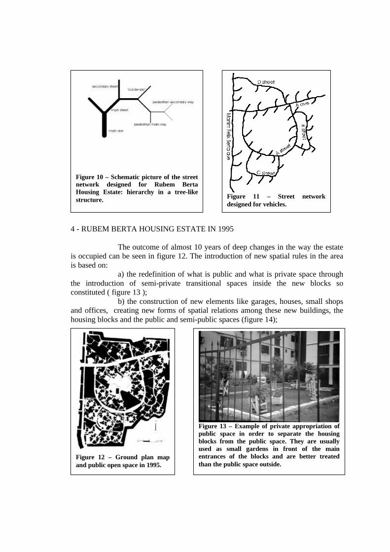
Like other elements of the project, the street network is based on a verystrict hierarchy which is reflected in the correspondence among function, use and size(figure 10). The whole network is conceived as a blocked system, i.e., main ringsconnect the estate without linking it to the outside world - with the exception of Aave. and Martim Felix Berta ave. which is a limit of the area. Every cluster is linked toone of these main rings through a dead-end street and there are no streets alowing topass from one cluster to another by car (figure11).
The project proposes the cars to be parked in some open space parkinglots or in the streets. The assumption that this kind of people seldom have cars and ifthey do they can be parked in the streets, far from any kind of owner’s control, isresponsible for an important part of the large scale transformations within the estate.
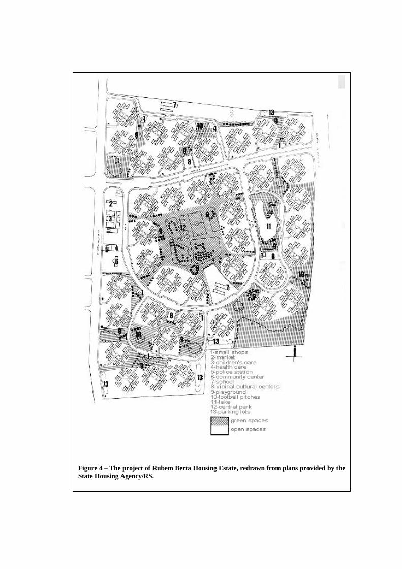
Figure 4 – The project of Rubem Berta Housing Estate, redrawn from plans provided by theState Housing Agency/RS.
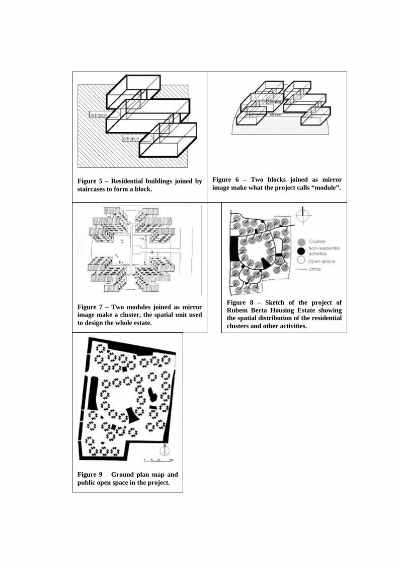
Figure 5 – Residential buildings joined bystaircases to form a block.
Figure 7 – Two modules joined as mirrorimage make a cluster, the spatial unit usedto design the whole estate.
Figure 9 – Ground plan map andpublic open space in the project.
Figure 6 – Two blocks joined as mirrorimage make what the project calls “module”.
Figure 8 – Sketch of the project ofRubem Berta Housing Estate showingthe spatial distribution of the residentialclusters and other activities.
4 - RUBEM BERTA HOUSING ESTATE IN 1995
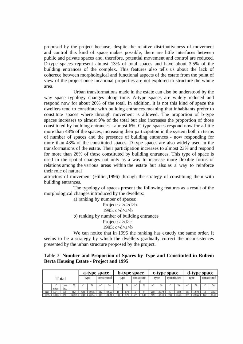
The outcome of almost 10 years of deep changes in the way the estateis occupied can be seen in figure 12. The introduction of new spatial rules in the areais based on:
a) the redefinition of what is public and what is private space throughthe introduction of semi-private transitional spaces inside the new blocks soconstituted ( figure 13 );
b) the construction of new elements like garages, houses, small shopsand offices, creating new forms of spatial relations among these new buildings, thehousing blocks and the public and semi-public spaces (figure 14);
Figure 10 – Schematic picture of the streetnetwork designed for Rubem BertaHousing Estate: hierarchy in a tree-likestructure. Figure 11 – Street network
designed for vehicles.
Figure 12 – Ground plan mapand public open space in 1995.
Figure 13 – Example of private appropriation ofpublic space in order to separate the housingblocks from the public space. They are usuallyused as small gardens in front of the mainentrances of the blocks and are better treatedthan the public space outside.

c) the use of walls and fences as elements of partition of the previouslypublic space through which many public/private connections are now being made andsemi-public spaces are introduced inside the new blocks as well (figure 15);
d) the increase of the built area of flats located on the ground floor(figure 16);
e) the use of public spaces to create courtyards for the private use ofthe owners of flats located on the ground floor ( figure 17);
f) the use of large public areas usually assigned to squares by theproject to create entirely new residential areas (figure 18).
These kind of mechanisms are responsible for enormous changes in thespace use within the estate. Compared to the 80.44% of public spaces and less than20% of private spaces proposed by the project, these proportions are now 45.38% and54.62% respectively.
As new buildings are built up and public spaces are fenced new formsof alignements are created. These new blocks when put together with contiguous onesform a new net of ways, very similar to those found in traditional settlements.Throughthis process almost every trace of the original layout of the estate has desapeared.
Figure 14 – Examples of new builtelements: houses and garages on theleft and shops above.
Figure 15 – Example ofwalls, buildings and fencesredesigning both public andprivate spaces.
Figure 16 – Example offlat located in the groundfloor with new built areaincreasing the flat.

As a result of the individual interferences on the space of the estate byusing the above mentioned spatial mechanisms it is possible to say that, as a whole,the changes introduced within the estate tend to:
a) isolate the housing blocks from direct contact and from being underscrutiny of public space as alowed by the conditions imposed by the project;
b) group together residential blocks from different or same clusters atthe same time creating new spatial units, very similar to those found in traditionallayouts, and breaking up the spatial order of the project centred on the idea of thehousing cluster;
c) align new buildings along the existing ways or along the onescreated by the physical transformations of the estate;
d) create a street network based on the one of the project but with amore flexible use, and more similar to street networks found in traditional residentialareas;
e) define the frontage of the main streets as the most importantlocations for non-residential activities such as shops, services, offices and smallindustries like usually is in traditional urban areas.
5 - URBAN STRUCTURE IN RUBEM BERTA HOUSING ESTATE
This part of the paper intends to discuss the urban structure of theestate both in the project and in the situation in 1995. In order to do so it is usedconfigurational analysis based on space syntax techniques (Hillier and Hanson, 1984).Due to the limits of this paper it is not intended to present the whole theory an relatedtechniques on space syntax. Only some basic concepts and tools are explored here.For a full account of the theory it is suggested the following basic works: Hillier andHanson, 1984; Hanson, 1989; Hillier et alli, 1993; Hillier, Hanson and Grahan, 1987;
Figure 17 – Example showing the use ofpart of public space to create a courtyardfor the ground floor flat and the increase ofits built area as well. The flat located on theupper floor use the structure bellow tocreate a private varanda with a barbecue.
Figure 18 – Example of an entirely newresidential area which invaded a placedesigned to be a square.

Peponis et alli, 1989; Hillier, 1996, among others. Because they deal withconfigurational features of urban space, these techniques allow:
a) sistematically describe the physical dimension of urban morphology;b) to describe both the particularities of each space in a system and its
relations to all others;c) to describe aspects of spatial culture (Hillier, 1996) that underlie
morphological features of the space;d) to compare different spatial systems both in terms of size and
morphology.Space syntax theory and techniques are based on the following main
arguments:a) every urban settlement can be seen as a continuous system of open
spaces whose forms result from the way buildings and other kinds of limits topeople’s movement are put together in a whole;
b) every urban settlement, seen as a sequence of open spaces andbuilding system, is the field of the interface and interaction of two social categories:strangers and inhabitants. In this way, settlements are the place of relationshipsbetween inhabitants and between inhabitants and strangers.
The main goal of syntactic analysis is to describe urban layoutsthrough their syntactic properties, i.e., how the system as a whole is related to every ofits constituent parts and how the multiplicity of these relations produce an uderlyingstructure.
We can identify two fundamental dimensions in the organization ofurban morphology:
a) a local dimension, responsible for the closest relations betweenbuildings and the parcel of public space to which they are connected;
b) a global dimension which structures the whole spatial systemallowing to understand not only how the parts are organized but also what is thenature of the relations that structure the system as a whole.
These dimensions can be objectively measured through their syntacticproperties. The basic source of information about local properties is organized in theform of a convex map (Hillier and Hanson, 1984) which represents the break-up of theopen space system into the least number of the larger convex spaces that can bedrawn, together with the distribution of the interfaces between building entrances andpublic spaces. Convex maps can be analysed both in terms of the properties of everyconvex space and relational patterns among them as well. Convex maps can bereduced to graphs which makes it easier to study and compare configurational featuresof spatial systems. Global organization is represented by the axial map, basic tosyntactic analysis. It consists of the representation of the continuous system of openspaces through the fewest and longest lines of accessibility that cross all convexspaces and connect all open space (Hillier and Hanson, 1984). In this way, it explainsabout the possibilities of movement to and across the spatial system.
The analysis of local and global patterns allows to compare differentspatial systems and to understand how configuration is associated to social use ofspace, to movement patterns and to conditions in which social interfaces are held.

5.1 - Local Patterns
Convex map can inform us about every space within a particularsystem. Features such as size, shape, relations of contiguity, presence of buildingentrances, etc. can explain about differences between one space and another one and,therefore, how they respond to different conditions of social appropriation in thespace.
The following measures of convex spaces were studied for RubemBerta Housing Estate:
a) mean area;b) mean area per building entrance;c) number of building entrances per convex space;d) percentage of convex spaces with no building entrances;e) perimeter of convex space per building entrance;f) percentage of public space of the whole settlement.The results for Rubem Berta Housing Estate concerning local measures
can be observed in the table 1 bellow.Regarding the situation related to building entrances, we may say that:a) The mean area of convex space per building entrance in 1995 is
almost 5 times smaller than that found in the project and it is likely to findaproximately one building entrance per convex space in average. This is mainly dueto the introduction of a large number of new buildings all over the estate which areresponsible for reducing the length of convex space perimeter from one buildingentrance to another one.
b) There is still a large proportion of spaces with no building entrances.This is mainly due to a large part of the new buildings introduced in the area to beused as garages and they are not considered as creating social interfaces as do thosebuilt for shops and houses, for example. Despite this methodological choice, it isimportant to remark that most of the garages are used during the weekends asextensions of the flats
Table 1: Convex Measures for Rubem Berta Housing Estate - Project andSituation in 1995
MEASUREMOMENT nº of
spacesmeanarea(m2)
meanarea/
buildingentrance
(m2)
buildingentrance/convexspace
% convexspaceswith nobuild.
entrance
perimeter/ buildingentrance
(m)
%publicspace/totalarea
Project 1,041 435.12 1,136.33 0.38 68.30 149.37 80.441995 1,183 219.56 240.63 0.91 61.28 56.23 45.38

- as a barbecue - and become the places to meet neighbours and friends coming fromoutside the estate. In this sense, not only the small buildings themselves becomeintensily used but also is the public space in front of the garages.
In order to improve the analysis, besides the quantitative features of theestate it is important to consider relational features associated to the local dimensionof urban space which structures the entire estate through local patterns, i.e., the overallstructure created by the physical transformations individually introduced by theestate’s dwellers.
The positioning of every space within a system is crucial to understandhow society organizes their spaces to fulfil their social roles, optimizing form andfunction. The properties of space such as depth, contiguity, degree of constidudinessby building entrances, size, etc. inform us not only about form and relative location ofthe spaces but, fundamentally, about how social categories use the space as animportant instrument for regulating social relations.
The property called steps from building entrances shows us howpeople moving around a spatial system are positioned regarding building entrances,i.e., the social interfaces that connect public and private spaces wich is able to “feed”public space with people moving from or to the buildings. This property deals withthe distance in terms of number of steps or different spaces required to move fromeach space to the next one where it is possible to find at least one building entrance.This tells us about the conditions of scrutiny and control one can experience whenmoving around in a particular urban area.
Regarding the project, spaces inside the clusters present a repeatedsituation and are the closest spaces from/to building entrances of all estate. Thismeans that in spaces inside the clusters people are one, two or three steps frombuilding entrances and are, in a great extent, submited to a good control of movement.Nevertheless, outside the clusters the situation is ratter different. Actually, the spacesresponsible for linking the clusters are the most distant from/to building entrances ofthe whole system and, therefore, where the scrutiny over dwellers’ or strangers’movement is more difficult. This spatial pattern suggests that the clusters work asisolated spatial units and that global interfaces are not sought by the project. Thecentral park and the surrouding spaces, for instance, are the most deep in terms ofaccessibility to/from building entrances of the entire estate. This solution seems quiteodd if we take into account that these spaces are supposed to agregate the use andencounters of the whole collectivity of the estate.
The situation in 1995 shows a quite new relational structure. Similarlyto what usually happens in traditional urban fabrics, now it is more likely to passthrough a continuous system of spaces constituted by building entrances within thewhole estate, mainly along the most important streets. Spaces one or two steps farfrom building entrances respond now for more than 74% of total spaces while thisproportion in the project was around 50%.
The overall results regarding this particular aspect of the analysis canbe seen in table 2 bellow.

Table nº 2: Depth from Building Entrances of the Spaces of Rubem BertaHousing Estate - Project and Situation in 1995
STEPS FROM BUILDING ENTRANCES (%)Moment 1 2 3 4 5 6 7Project 32.23 18.70 20.45 19.18 8.96 0.49 -1995 40.14 34.12 16.26 6.01 2.46 0.76 0.25
One of the main spatial properties of traditional layouts is thepossibility of passing through a sequence of spaces constituted by building entrances.This property is very important as part of controlling and using the space. In order tomake a closer analysis of this spatial property two maps were drawn: thedecomposition map and the converse decomposition map. In the former, spaces arerepresented by small circles and contiguous spaces are connected by lines only if thereis at least one building entrance in both of them. In the latter, conversely, spaces arerepresented by small circles and contiguous spaces are connected by lines only if thereare no building entrances in both of them. In doing so it is possible to observe howcontiguous spaces of a system are connected to each other allowing to grasp anoverall picture of forms of spatial use and appropriation of public space from locallyproduced spatial patterns.
The decomposition map of the project of Rubem Berta Housing Estate(figure 19) consists basicaly in the representation of the spaces themselves. There areonly two situations where contiguous spaces are both constituted by buildingentrances:
a) along Martim Felix Berta ave. - east limit of the estate - due to thebuilding entrances related to the area outside the estate;
b) along the commercial area.The access to the residential clusters is always made by unconstituted
spaces. This can be best seen in the converse decomposition map of the project (figure20): most of the spatial relations are among unconstituted spaces.
As a result of the spatial transformations in the estate there is a shift inthis property (figure 21 and figure 22). The spatial rules used by the residents tend toform periferically constituted new blocks instead of enclosing the building entrancesin the clusters like it is in the project. A better spatial definition of the street networkis followed by their constitution by building entrances. We can say that, more andmore, the relations among contiguous spaces are relations among constituted spacesas we usually find in traditional urban areas.
Another approach that we can make in order to understand howspecific conditions of use and spatial control and appropriation are related to aspectsof space configuration can be grasped by analysing the kind of spatial arrangement ofa settlement. In some spaces, control and movement are distributed in the layoutthrough the ringness property which makes possible alternatives of throughmovement. This kind of arrangement is called distributed (Hillier and Hanson, 1984).In some other spaces, control and movement are strongly ordenated once there are noalternatives of through movement. This kind of arrangements are called non-

distributed (Hillier and Hanson, 1984). In a distributed system of spaces, from onespace to another, there is more than one possible route to reach it and, therefore, thespatial control can be dispersed in many of the spaces within the system. In a non-distributed system of spaces, in turn, from one space to another there is only onepossible route to reach it and, therefore, this system tends to present an unified spatialcontrol only in part of the spaces. In ordinary urban fabrics we usually find bothsituations simultaneously, i.e.:
Figure 20 – Conversedecomposition map of the Project.
Figure 21 – Decomposition map in1995.
Figure 22 – Converse decompositionmap in 1995.
Figure 19 – Decomposition mapof the Project.

a) public spaces around blocks are connected by permeability relationsstructuring different rings which allow many alternative routes from/to spaces -distributive arrangements;
b) the access to some spaces can only be made through some otherspecific intervening ones which work as transitional spaces - non-distributivearrangements.
Spatial control and movement are clearly different depending on thespecific kind of space one is within a spatial system and, at the same time, on thespatial relations which are possible to establish from every one of these spaces. Hillier(1996) suggests the following typology of spaces through a simple graph wheretopological properties of space can be grasped (figure 23):
a) a-type spaces - with a single link and “by definition dead-end spacesthrough which no movement is possible to other spaces. Such spaces have movementonly to and from themselves...” (Hillier, 1996:319).
b) b-type spaces - with more than one link but in the way to/from a-type spaces, forming tree-like structures meaning that there is
“exactly one route from each space to every other space (...). This implies that movementthrough each constituent space will only be to or from a specific space or series of spaces.This in turn implies that movement from origins to destinations which necessarily passthrough a b-type space must also return to the origin through the same space” (Hillier,1996:319).
c) c-type spaces - with more than one link, they are constituent parts ofonly one ring where there are neather a-type nor b-type spaces. “Movement from a c-type space through a neighbour need not return through the same neighbour but mustreturn through exactly one other neighbour” (Hillier, 1996:319-20).
d) d-type spaces - with more than two links to others belonging to atleast two different rings where there are neither a-type nor b-type spaces and “mustcontain at least one space in common.(...) Movement from d-type spaces through aneighbour has the choice of returning by way of more than one other neighbour”(Hillier, 1996:320). Its importance in a system can be seen in figure 24 where the
Figure 23 – Space typology. From: Hillier(1996:318).
Figure 24 – Without the d-type space linksthe spatial system is reduced to an a- and b-type system. From: Hillier (1996:318).

removal of d-type space links reduces the system to a single string of a- and b-typespaces.
The analysis of space typology of Rubem Berta Housing Estate helpsus to understand structural differences between the project and the situation in 1995.In order to do so, justified graphs2 (Hillier and Hanson, 1984) were made taking themain entrance of the estate as the root of the graphs. Besides the typology of thespaces, in the same graphs were recorded spaces with and without building entrances.
Regarding how deep the spaces of the state are from the point of viewof the main entrance, despite the number of spaces remains almost the same - 1,041 inthe project and 1,183 in 1995 - the system is shallower in the project and is eighteensteps deep. In 1995 the system is twenty-nine steps deep. The deepest spaces in theproject are located in the extremity of A ave., in accordance to metric distance. In1995, instead, the deepest spaces are located in the centre of the layout in thesoutheast border of the central park (figure 25). In this case, topological segregationdeceives the metric proximity and shows that spatial changes seem to have beenintroduced in the estate as a strategy to modify the whole accessibility system amongspaces, creating different ways to superimpose or to move apart social categoriesthrough the built space.
Table 3 bellow presents some figures relating space transformation tospace typology in the estate.
In the project, almost 60% of spaces are dead-end spaces - a-type -where almost 95% of the building entrances are located, meaning that they arepredominantly located in spaces of to movement and scarcely in spaces of throughmovement as in traditional layouts. B-type spaces which belong to tree-like sequencesof spaces are quite few - less than 2% - and there are no building entrances on them.C-type spaces respond for about a quarter of total spaces but represent less than 2% ofthose constituted by building entrances. This also confirms the odd urban structure
2 The graphs are not included in this paper.
Figure 25 – The deepest spaces in the system migratefrom the Project to 1995 due to spatial transformations.
proposed by the project because, despite the relative distributiveness of movementand control this kind of space makes possible, there are little interfaces betweenpublic and private spaces and, therefore, potential movement and control are reduced.D-type spaces represent almost 13% of total spaces and have about 3.5% of thebuilding entrances of the complex. This features also tells us about the lack ofcoherece between morphological and functional aspects of the estate from the point ofview of the project once locational properties are not explored to structure the wholearea.
Urban transformations made in the estate can also be understood by theway space typology changes along time. A-type spaces are widely reduced andrespond now for about 20% of the total. In addition, it is not this kind of space thedwellers tend to constitute with building entrances meaning that inhabitants prefer toconstitute spaces where through movement is allowed. The proportion of b-typespaces increases to almost 9% of the total but also increases the proportion of thoseconstituted by building entrances - almost 6%. C-type spaces respond now for a littlemore than 48% of the spaces, increasing their participation in the system both in termsof number of spaces and the presence of building entrances - now responding formore than 43% of the constituted spaces. D-type spaces are also widely used in thetransformations of the estate. Their participation increases to almost 23% and respondfor more than 26% of those constituted by building entrances. This type of space isused in the spatial changes not only as a way to increase more flexible forms ofrelations among the various areas within the estate but also as a way to reinforcetheir role of naturalattractors of movement (Hillier,1996) through the strategy of constituing them withbuilding entrances.
The typology of spaces present the following features as a result of themorphological changes introduced by the dwellers:
a) ranking by number of spaces:Project: a>c>d>b1995: c>d>a>b
b) ranking by number of building entrancesProject: a>d>c1995: c>d>a>b
We can notice that in 1995 the ranking has exactly the same order. Itseems to be a strategy by which the dwellers gradually correct the inconsistencespresented by the urban structure proposed by the project.
Table 3: Number and Proportion of Spaces by Type and Constituted in RubemBerta Housing Estate - Project and 1995
a-type space b-type space c-type space d-type spaceTotal type constituted type constitute
dtype constituted type constituted
nºspac
constitu.
% nº % nº % nº % nº % nº % nº % nº % nº %
Proj 1,041 330 31.7 622 59.75 312 94.55 18 1.73 0 0 268 25.74 6 1.82 133 12.78 12 3.631995 1,183 458 38.72 243 20.54 111 24.24 103 8.71 27 5.89 569 48.10 198 43.23 268 22.65 122 26.64

5.2 - Global Patterns
Concerning global measures, this paper basically deals with one ofthem: integration and integration core. The property of integration involves the notionof symmetry/asymmetry, concerning the relation of two spaces with a third one. Adescription will be said symmetric if the relation between two spaces is symmetricalas will be the relation of both with a third one.
The notion of symmetry/asymmetry always involves some notion ofdepth or, in other words, the number of changes of direction necessary to move fromone space to another. Relations of depth can be generalised by the measure of relativeasymmetry, or a more complex one, real relative asymmetry (1/RRA), by comparinghow deep the system is from a particular space with the deepness it theoretically couldbe, in a sample of systems of different sizes (Hillier and Hanson, 1984).
The properties of the integration core are of particular interest. Thecore comprises those spaces more easily accessible in the urban layout as a whole -usually the 10 percent most integrating spaces. In particular, what matters is the typeof pattern made by the distribution of the more integrating spaces in a system (Hillierand Hanson, 1984).
The results for Rubem Berta Housing Estate concerning globalmeasures can be observed in the table 4 bellow.
Mean integration value decreases from the project to the situation in1995. Compared to the original situation which presents a spatial system quiteintegrated and shallow with a mean depth of about three lines, in 1995 the spatialsystem is less integrated and deeper presenting a mean depth twice as much, i.e., ofalmost six lines. The strong spatial integration presented by the project not necessarilymeans more favorable conditions of space use and occupation. Extremely high valuesof integration like that of the project are usually found in morphologies where thespatial control is mainly based on the movement of strangers across the spatialsystem.
In Rubem Berta Housing Estate the steady reduction of integrationvalues and the construction of a deeper spatial system tend to:
a) reduce the role of global control - strangers-related - reinforcinglocal control - inhabitants-related;
b) balance global and local spatial organization and, therefore, thecontrol between strangers and inhabitants;
c) introduce local spatial control as an important aspect of the processof spatial use and appropriation;
Table 4: Global Measures for Rubem Berta Housing Estate - Project andSituation in 1995
Moment nº of lines 1/RRAProject 451 3.465831995 544 1.61529

The spatial distribution of integration can be seen in figures 26 and 273.In the project we can observe the following features:a) the most integrated lines are spread all over the estate, a large
number of them crossing each other making it difficult to identify a clear integrationcore;
b) the street system, once is scarcelly related to the built system, doesnot necessarily includes the most integrated spaces. The whole accessibility given bythe integration core is practically independent from the one proposed through thestreet network;
c) the syntactic core in the project lies in the geometric centre of thewhole composition, i.e., the central park concentrates most integrated lines. Thissolution reinforces the importance of an enclosed space instead of producing a betterconnection to the outside world. In addition, the integration core has nocorrespondence between the spatial distribution of land use as we usually find inordinary urban layouts: the more important are the functions the more they tend to belocated in the most accessible spaces.
d) the most segregated spaces tend to be concentrated inside theresidential clusters, where most of the building entrances are. Pratically there is nointerfaces between public and private spaces along the most integrated lines.
As the result of the urban transformations introduced by the dwellers ofthe estate, the following changes in the features of the integration core were produced:
a) the most integrated spaces allow the connection of all spacesthrough these lines;
b) the most segregated spaces tend to be in the limits of the estate onceit still remains relatively blocked to some outside areas mainly in the east andsouth.
3 These figures were obtained through AXIAL3 software developped by Luciano Domenico Giordanaunder the supervision of Prof. Frederico de Holanda from The University of Brasilia, Brazil.
Figure 27 – Integration core in 1995:most integrated lines in thick blackand most segregated lines in grey.
Figure 26 – Integration core in theProject: most integrated lines in thickblack and most segregated lines in grey.
Other segregated lines lie on the interstices of the most integrated lines making clearwhere are the spaces of global and spaces of local control. In this way, it is possibleboth the movement of strangers in the segregated areas and their control byinhabitants as well;
c) the residential areas concentrate great part of the spatial segregation.There is a coherence between space use and degree of accessibility;
d) the most integrated spaces recover the syntactic relevance of themain rings of accessibility as proposed by the project. The street network is not onlytraces in the paper as in the project but structural elements for spatial configurationand social appropriation;
e) most integrated lines tend to cross through spaces constituted bybuilding entrances. Along these lines we find most of the non-residential activities,mainly retail shops, services, offices, etc., similar to traditional layouts;
f) the park in the geographical centre of the area looses its syntacticrole in the composition and now there are no most integrated lines crossing it as in theproject;
g) the new urban structure introduced by the dwellers of the estate tellsus about the relevance of local organization – how segregation is distributed and howit is related to residential land use – and, at the same time, about the relevance ofglobal organization in the sense that it is used as a way to relate integration andsegregation and to ensure the connections of the estate to the outside world, denyingthe strong spatial/social enclosure proposed by the project.
It is interesting to observe that some well integrated spaces in theproject are kept in the urban transformations. This aspect reveals that the steadyindividual changes in the space work in two related ways: they locally alter the wholeestate but, at the same time, they keep unchanged some of the spaces which areresponsible for the global organization. In this way, local transfomations seem to beguided by certain limits that can not be crossed because of the risk of afecting theglogal organization and, therefore, how the various spaces relate within the estate andto the ouside world as well.
If we compare axiality and social interfaces created by the distributionof building entrances in space other particularities of urban structure and potentialmovement can be grasped.
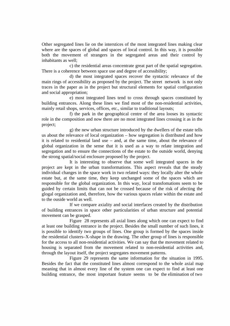
Figure 28 represents all axial lines along which one can expect to findat least one building entrance in the project. Besides the small number of such lines, itis possible to identify two groups of lines. One group is formed by the spaces insidethe residential clusters–X-shape in the drawing. The other group of lines is responsiblefor the access to all non-residential activities. We can say that the movement related tohousing is separated from the movement related to non-residential activities and,through the layout itself, the project segregates movement patterns.
Figure 29 represents the same information for the situation in 1995.Besides the fact that the constituted lines almost correspond to the whole axial mapmeaning that in almost every line of the system one can expect to find at least onebuilding entrance, the most important feature seems to be the elimination of two
spatially different layers of movement as it is suggested in the project, superimposinglocal and global patterns of movement. This means that the dwellers structure thepotential movement as a system where the housing-related movement can always beconnected at the same time to the movement related to other activities. Therefore, thedwellers refuse both the spatial/social hierarchy and the enclosure imposed by theproject. In sum, the dwellers refuse the fragmentation – social through spatial throughsocial – in favour of the estate as a whole.
6 - CONCLUSIONS
There are two main issues to be dealt with in this final part of the paperafter the analysis of the process of spatial transformations held in Rubem BertaHousing Estate for about 10 years:
a) local patterns of spatial transformations;b) the construction of spatial integration.What is intended here is to identify some physical invariants used to
build up the new settlement which uderlie the individual spatial changes both in termsof what has been locally done and what is the global outcome.
Individual changes produce a new structure for local spaces meaningthat there is a new approach to the interfaces between public and private spaces with aresponse in the way movement patterns and space control can be made and, at thesame time, organizing new forms of global accessibility within the estate once thewhole accessibility system has been changed.
Figure 28 – Lines with at least onebuilding entrance in the Project:movement segregation.
Figure 29 – Lines with at least onebuilding entrance in 1995:movement integration.
The spatial repetition and indiferentiation suggested by the project arealtered by the dwellers in favor of an urban structure where patterns ofintegration/segregation are responsible for producing local differences and globalstructuration, affecting movement and spatial control and how land use patterns relateto the new configuration.
A close analysis of the mechanisms of spatial transformations used inRubem Berta Housing Estate, including block aggregate in order to understand howprivate and public space networks are organized, allow us to identify some spatialrules which can be related to three simultaneous forms of alignement (Hillier,1996:335/68):
a) alignement of blocks – the new blocks tend to be built along thesame alignement;
b) alignement of entrances – building entrances tend to follow the samealignement rule along the line;
c) parallel alignement – alignement of blocks and building entrancestend to be made in both sides of the same alignement. Public space tend to be morelinear and, at the same time, with bilateral occupation and constitution.
We can notice that, despite the wide range of local differences such asgeometry and size of blocks, size and shape of convex spaces and lenght of theirperimeters, the whole new morphology can be explained in terms of how the abovementioned forms of alignement are arranged in space.
The alignement of blocks and parallel alignement produce a series oflinear streets, often interrupted, creating a specific kind of urban grid defformationand different degrees of spatial integration once the break-up of spatial continuity, thekind of spatial contiguity and spatial relations within the whole system are responsiblefor the differentiation in the relative accessibility among spaces.
Regarding the construction of spatial integration we may say that localrules as used by the dwellers of Rubem Berta Housing Estate are primarily related tothe way spatial integration is organized in order to achieve a correspondence betweenform and function, to create a “spatial culture” (Hillier, 1996:337) and, in the case ofurban design, to legitimize the design by the potential social use of space created bythe way every space is put into relation to all others within a spatial system.
This process of constructing spatial integration as a strategy mediatedby spatial regularities can be better understood through some simulations made inorder to identify how spatial integration behaves as a settlement grows. Hillier (1996)explains that taking a building with its entrance, building entrances tend to attract thegreatest spatial integration. If we associate this building with another similar onecreating some sort of alignement we can notice how integration changes. If buildingentrances are aligned, most of the integration tends to concentrate along the space infront of building entrances. If, on the one hand, the alignement of buildings produce agreater integration along the alignement and not on the sides of the buildings, on theother hand, the alignement of building entrances informs about in what side of thealignement the greatest integration will be formed. If building entrances are locatedback to each other or one facing the back of the other building, in both situations it isnot easy to antecipate where the most integrated spaces will be formed and the

integration along the alignement of building entrances tend to be reduced. As Hillier(1996:359) says:
“Cell alignement ‘means’ the creation of a linear integration structure along the surfaces ofaligned cells; entrance orientation specifies on which side is to occur. In the absence of oneor other we will not find the invariant pattern we have noted. The two together have theeffect of eliminating local indeterminacy in the form and creating a robust emergent patternof integration in the aggregate.”
In Rubem Berta Housing Estate, one of the principles of designing thehousing blocks is that of opening all building entrances facing the internal space ofthe cluster as it is sketched in the figure below (figure 30).
If we take this small system separately from all others we can noticethat the centre of the system concentrates the greatest spatial integration, i.e., thecentre is the most accessible place in the cluster. However, if we take more than oneof such clusters and put them into relation the whole accessibility system changes.From the point of view of the outside, the centre of the cluster is now the lessaccessible and, therefore, the most segregated space (figure 31).
We can observe here what Hillier (1996:341) calls paradox ofcentrality meaning that
“maximasing internal integration also maximises external segregation. (...) Growing urbansystems must respond to the paradox of centrality because it has the simple consequencethat if you try to maximise internal integration then you lose external integration and viceversa, and urban forms seem to need both internal and external integration. The tensionbetween internal and external integration leads settlementes to evolve in ways whichovercome the centrality paradox.”
It seems exactly to be the case in Rubem Berta Housing Estate wherethe internal space of the clusters, because of their shape and the positioning ofbuilding entrances, tend to concentrate the greater segregation of the entire system ascan be seen in figure 26.
The enclosure of the residential clusters is destroyed by the dwellersthrough the morphological alterations following the above mentioned alignementrules which are responsible for deep changes in the relative accessibility within theestate and between the estate and the outside world.
Figure 30 – Schematicrepresentation of a clusterand its building entrances.
Figure 31 – Schematic representation of twoconnected clusters and their building entrancesillustrating the paradox of centrality.

From the point of view of local organization, dwellers are trying tosolve conflicts originated from the morphology of the project through the mentionedmechanisms of spatial alterations. They create a local order by producing someconstant relations between a block and its neighbours that are repeated as a structuredespite their peculiar shapes and geometries.
The alignement rules used in the space transformation lead to deepchanges in the local space typology and, therefore, in the objective conditions of spacecontrol, use and movement. In this way, the alignement rules produce a morphologicaldifferentiation which is superimposed by a space typology differentiation.
Regarding the global patterns of spatial transformations, globalstructure in Rubem Berta Housing Estate is obtained by keeping some of the spaces ofthe estate more continuous which ensures that the greatest accessibility isconcentrated in the spaces responsible for connecting different sub-areas in the estate.
If individual changes were made only by taking into account localorganization according exclusivelly to individual interests, this would probably lead toa less intelligible spatial system and the urban grid would tend to be stronglydefformed, mainly localized relations could be held and links between sub-areas to theoutside would be particularly difficult.
In Rubem Berta Housing Estate morphological transformations andtheir results in terms of the creation of a spatial integration system follow exactly thedwellers’ concern about individual actions on space. Keeping the main streetscontinuous the parts of the whole are structured, relations among them are ensuredand contacts with the outside world can be easyly made.
In sum, there are interfaces between:a) an interconnected system of spaces more linear, responsible for the
global organization of the whole estate and for linking the estate to the outside;b) a system of smaller and more defformed linear spaces which makes
it possible differences in the forms of relative accessibility and a more localizedspatial control.
The analysis of the transformations that has been done in the estateallows us to observe that gradually the morphology is becoming more and moredistant from the morphology proposed by the project with the introduction of somespatial rules which we can identify all over the estate.
The history of spatial occupation and transformation of Rubem BertaHousing Estate is a clear example of the close relations between social components ofspace and spatial components of society. We may say that the more the morphologicalpatterns are disconnected from social implications the more we tend to have a strongresponse against it as is the case of Rubem Berta Housing Estate and in so many otherestates.
Spatial simplifications imposed by housing agencies which areresponsible for making decisions related to how thousands of people will live, usuallybased on a simplistic hierarchical disposition of spatial elements fall flat thediscussion about fundamental issues regarding designing urban areas like thatilustrated in this paper. In this sense, this case study is quitte usefull to understand the

role of architectural discipline in producing urban spaces and how important is thesupport of design criticism.
7 – REFERENCES
Hanson, J. (1987) Order and structure in urban design: the plans for the rebuilding ofLondon after the great fire of 1666, in Ekistics. Vol. 56, nº 334/335, Jan./Feb.– Mar./Apr., pp.22-42.
Hillier, B. (1996) The Space is the Machine. Cambridge University Press, Cambridge.
Hillier, B. (1988) Against Enclosure, in Rehumanizing House. Neymour, N.; Markus,T.; Wooley, T. (editors). Butterworths, London, pp.63-88.
Hillier, B. and Hanson, J. (1984) The Social Logic of Space. Cambridge UniversityPress, Cambridge.
Hillier, B. et al. (1993) Natural movement: or configuration and attraction in urbanpedestrian movement, in Environment and Planning B: Planning and Design.Vol. 20, pp.29-66.
Hillier, B.; Hanson, J.; Grahan, H. (1987) Ideas are things: an application of the spacesyntax method to discovering house genotypes, in Environment and PlanningB: Planning and Design. Vol. 14, pp.363-385.
Peponis, J. et al. (1987)The spatial core of urban culture, in Ekistics. Vol. 56, nº334/335, Jan./Feb. – Mar./Apr., pp. 43-55.
Rigatti, D. (1997) From design to use: morphological paradigms in Rubem BertaHousing Estate, Ph.D. Thesis, Architecture Graduate School, University ofSão Paulo.