reducing risk in the english channel/la manche traffic...
TRANSCRIPT
Reducing Risk in the English Channel/La Manche Traffic Separation Schemes
Reference: 31089/Version 1.2 Date: May 2009 Commercial-In-Confidence

Commercial-In-Confidence UK/France Formal Safety Assessment: 31089/1.2 Reducing Risk in the English Channel/La Manche Traffic Separation Schemes May 2009
BMT Isis Ltd Commercial-In-Confidence
Administration Record
Issue Modification Approved
Draft Final
Draft Final Deliverable JL
1.1 Updated with Review Comments JL
1.2 Update following Second Review RG
No. Of Pages Copy No. Collated By:
Proposal Authorisation
Author
Ron Gerdes
Checked
Jerry Stanley
Certified
Julian Lockett
© BMT Isis Limited This document contains proprietary and confidential information which may not be used or reproduced in whole or in part, or communicated to a third party without prior written consent of BMT Isis Ltd.
Commercial-In-Confidence UK/France Formal Safety Assessment: 31089/1.2 Reducing Risk in the English Channel/La Manche Traffic Separation Schemes May 2009
BMT Isis Ltd Commercial-In-Confidence
Executive Summary
BMT Isis Ltd is pleased to submit this Final Report, documenting our investigation into reducing risk in the English Channel/La Manche Traffic Separation Schemes (Dover Strait/Pas de Calais, Les Casquets and Ouessant) through the conduct of a Formal Safety Assessment (FSA) – contract number MSA 10/10/301.
It is well known that the Traffic Separation Schemes (TSS) have significantly improved safety since their introduction, and we have found that it is possible to offer further improvements that would be highly cost beneficial. These include:
a. Charting a recommended route south of the Varne for southbound vessels over 130 metres length.
b. Clarifying on charts the crossing zone for vessels leaving the NE lane and crossing the SW lane in the region of Mid Pas de Calais (MPC) buoy.
c. Increasing the level of proactivity of Vessel Traffic Services (VTS) operators, representing a “second pair of eyes”, detecting collision/grounding courses and other situations that could lead to an incident (including speed in poor visibility) and appropriately alerting vessels (VTS operators being aided by automatic alarms). Note that VTS operators at the Channel Navigation Information Service and the Service de Traffic Maritime are already proactive when aware of a developing situation.
The latter improvement must be implemented such that the VTS role remains one of providing information rather than control.
A number of other improvements that are less cost beneficial are also included in the body of the report. These improvements have been assessed for their effectiveness and checked for the absence of any apparent secondary detrimental effects. Nevertheless, it would be prudent to monitor their performance (when implemented) and refine the implementation as appropriate.
In summary, the application of the Formal Safety Assessment Methodology for the purpose of reducing risk in the English Channel/La Manche Traffic Separation Schemes has resulted in the following main recommendations:
a. VTS systems to include alarms that detect potential collision, grounding and unsafe closing speed in poor visibility, based on integrated Radar and AIS data. VTS operators to notify vessels of the potentially dangerous situation observed.
b. On chart 5500 and all related media:
(i) The route south of the Varne is marked with a note "recommended route for vessels over 130 metres length";
(ii) The MPC buoy is marked with a note “vessels leaving the NE lane and planning to cross the SW lane should be aware of heavy traffic in the SW lane and change course to cross at an appropriate point".
Commercial-In-Confidence UK/France Formal Safety Assessment: 31089/1.2 Reducing Risk in the English Channel/La Manche Traffic Separation Schemes May 2009
BMT Isis Ltd Commercial-In-Confidence
This study has been based on the available data as stated in the body of the report and has not considered future developments that may affect vessel speeds.
Commercial-In-Confidence UK/France Formal Safety Assessment: 31089/1.2 Reducing Risk in the English Channel/La Manche Traffic Separation Schemes May 2009
i BMT Isis Ltd Commercial-In-Confidence
Contents Page No.
Administration Record
Executive Summary
1 Introduction 1
1.1 Background to the TSS and VTS 1 1.2 Report Structure 1 1.3 Disclaimer and Copyright 2
2 Summary of the Requirements 3
2.1 The Requirement 3 2.2 Data Available for the Study 4
3 Tasks Undertaken and Findings 6
3.1 Start-up 6 3.2 Task 1 FSA Steps 1 to 3 6 3.3 Hazard Identification – FSA Step 1 7 3.4 Determining Base Risk Levels – FSA Step 2 14 3.5 Identifying Risk Control Options – FSA Step 3 18 3.6 Summary of Proposed Risk Control Options 19 3.7 Client Liaison following Task 1 21 3.8 Task 2 FSA Step 3 continued - Assessing the Effectiveness of Risk
Control Options - Summary 22 3.9 Analysis associated with Assessing the Effectiveness of Risk
Control Options 25 3.10 Task 3 FSA Step 4 - Broad Orders of Cost and CBA 37 3.11 Task 4 FSA Step 5 -Decision Making Recommendations 38 3.12 Further Points of Interest 41 3.13 Commentary on Other Initiatives 42 3.14 Acknowledgements 42 3.15 Main References 43
4 Glossary of Terms 44
Figures
Figure 2.1 - Study Areas 3 Figure 3.1 - Steps in the FSA Process 7 Figure 3.2 - Crossing Incident Locations (29) 9 Figure 3.3 - Overtaking Incident Locations (16) 10 Figure 3.4 - Grounding Incident Locations (4) 11 Figure 3.5 - Approach and Passing Incident Locations (4) 12
Commercial-In-Confidence UK/France Formal Safety Assessment: 31089/1.2 Reducing Risk in the English Channel/La Manche Traffic Separation Schemes May 2009
ii BMT Isis Ltd Commercial-In-Confidence
Figure 3.6 - Leaving NE Lane and Crossing SW Lane Locations (5) 13 Figure 3.7 - Close Quarters Situations 16 Figure 3.8 - Collisions and Groundings 17 Figure 3.9 - AIS Data Analysis Areas 26 Figure 3.10 - Vessel Traffic Density 28 Figure 3.11 - 5 Cable encounters all TSSs 29 Figure 3.12 - 5 Cable encounters in the English Channel/La Manche TSS 30 Figure 3.13 - 3 Cable encounters in the English Channel/La Manche TSS. 31 Figure 3.14 - Illustration of traffic distribution in the NE and SW lanes area of
interest, together with 5 cable (925m) and 3 cable (555m) CPAs 32 Figure 3.15 - Raw AIS Data, Section 10 is shown by the yellow band 33 Figure 3.16 - Display showing bunching in the region of the Varne 34 Figure 3.17 - 3 Cable encounters Varne region. 35
Tables
Table 3.1 – MAIB Recorded TSS Incidents 14 Table 3.2 - Average number of vessels in NE and SW lanes 27 Table 3.3 – RCOs for Consideration 40 Table 4.1 - Glossary of Terms 45
Annexes
Annex A: Hazard Log Annex B: Cost Benefit Assessment Annex C: Weather Data Annex D: Ship Parameter Selection for Varne Routing
Commercial-In-Confidence UK/France Formal Safety Assessment: 31089/1.2 Reducing Risk in the English Channel/La Manche Traffic Separation Schemes May 2009
1 BMT Isis Ltd Commercial-In-Confidence
1 Introduction
1.1 Background to the TSS and VTS
1.1.1 The Dover Strait/Pas-de-Calais is the world's busiest international seaway, regularly used by up to 500 commercial vessels daily. It became the first International Maritime Organisation (IMO) approved Traffic Separation Scheme (TSS) in the world and was the first to come under full radar surveillance. Prior to its establishment there were on average 30 collisions per year in the Dover Strait.
1.1.2 The Channel Navigation Information Service (CNIS), introduced in 1972, provides a Vessel Traffic Service (VTS) Information Service for all shipping in the Dover Strait/Pas-de-Calais. It is jointly operated by the UK’s Maritime and Coastguard Agency (MCA) from Dover MRCC and by the French Affaires Maritime through the Service de Traffic Maritime (STM) at CROSS Gris-Nez in France.
1.1.3 As an Information Service the functions of CNIS and STM are to keep the Dover Strait TSS under observation, to ensure that essential information is provided in time for on-board navigational decision-making by the mariner, to monitor the flow of traffic and to detect and report vessels which contravene the International Regulations for Preventing Collisions at Sea 1972 (COLREGS), ultimately minimising the likelihood of a major incident in the Channel which may impact on the environment.
1.1.4 The Dover Strait is also a mandatory reporting area. Under regulation, vessels over 300 gross tonnes are required to make a report to either Dover MRCC (South West Lane) or CROSS Gris Nez (North East Lane) before proceeding through the VTS service area.
1.2 Report Structure
1.2.1 This document describes BMT Isis Ltd’s work in reducing risk in the English Channel/La Manche TSS through the conduct of a Formal Safety Assessment (FSA) – contract number MSA 10/10/301.
1.2.2 Steps 1 to 5 in the FSA process have been followed using available data as supporting evidence.
1.2.3 The report is structured in accordance with the FSA process, with the steps in the process grouped into tasks, in accordance with our proposal. The structure is as described below.
Commercial-In-Confidence UK/France Formal Safety Assessment: 31089/1.2 Reducing Risk in the English Channel/La Manche Traffic Separation Schemes May 2009
2 BMT Isis Ltd Commercial-In-Confidence
1.2.4 Section 2 summarises the requirements and describes the data that has been made available for the study.
1.2.5 Section 3 describes the tasks that have been undertaken and the findings, as detailed below.
1.2.6 Section 3.1 describes the start-up activities.
1.2.7 Sections 3.2 to 3.9 describe the activities undertaken for Steps 1 to 3 of the FSA Process.
1.2.8 In sections 3.3 to 3.6 hazards have been identified, risk assessed and Risk Control Options (RCOs) proposed. Section 3.7 then addresses the agreement of the Hazards Log (provided in Annex A) and the RCOs to be taken forward in the study.
1.2.9 In Section 3.8, the effectiveness of the RCOs is summarised and the corresponding analysis and assessment provided in Section 3.9.
1.2.10 The identification of accident costs and Cost Benefit Assessment (CBA) is summarised in Section 3.10 and detailed in Annex B.
1.2.11 Finally, the cost beneficial RCOs are ranked by their cost benefit ratio and presented in Section 3.11 for decision making by the appropriate organisations.
1.3 Disclaimer and Copyright
1.3.1 This report has been produced by BMT Isis Ltd under a contract with MCA, an Executive Agency of the Department for Transport (DfT). Any views expressed in this report are not necessarily those of the Department for Transport.
1.3.2 © Queen's Printer and Controller of HMSO - 2009 (year of first publication).
1.3.3 All enquiries relating to the copyright in the work should be addressed to HMSO, The Licensing Division, St Clements House, 2-16 Colegate, Norwich, NR3 1BQ.

Commercial-In-Confidence UK/France Formal Safety Assessment: 31089/1.2 Reducing Risk in the English Channel/La Manche Traffic Separation Schemes May 2009
3 BMT Isis Ltd Commercial-In-Confidence
2 Summary of the Requirements
2.1 The Requirement
2.1.1 The partners of the Anglo-French Safety of Navigation Group (AFSONG), the MCA and the Ministère de l’ecologie, de l’energie, du développement durable et de l’aménagement du territoire (MEEDDAT), considered that excessive speed of ships in the Dover Strait/Pas de Calais TSS may be a contributory factor in increasing the navigational risk associated with passage making in this area. The FSA approach is now an established methodology for investigating maritime safety issues and as such is a suitable approach to adopt to investigate this hypothesis. At their meeting on the 3rd October 2008 both the MCA and MEEDDAT agreed to a collaborative approach to funding a study to investigate navigational safety issues in this TSS, addressing in particular the role of excessive speed. This study was required to:
a. establish the risk of collisions, near misses and groundings in the Dover Strait/Pas de Calais posed by shipping
b. use the International Maritime Organisation’s (IMO) FSA methodology to investigate this issue
c. propose risk mitigation measures and to rank speed management within the possible RCOs
d. conduct a high level Cost Benefit Assessment for the identified RCOs.
2.1.2 The study areas are the Dover Strait/Pas de Calais TSS (51 23N 001 25E, 51 03N 002 22E, 50 13N 001 36E and 50 43N 000 16E) and the two French TSSs of Les Casquets and Ouessant (see Figure 2.1).
Figure 2.1 - Study Areas
Commercial-In-Confidence UK/France Formal Safety Assessment: 31089/1.2 Reducing Risk in the English Channel/La Manche Traffic Separation Schemes May 2009
4 BMT Isis Ltd Commercial-In-Confidence
2.1.3 The MCA suggested that a desktop FSA study could draw upon a number of identified data sources namely:
a. Other traffic surveys undertaken in the UK and France in recent years.
b. The MCA Automatic Identification System (AIS) network and the French ‘Trafic 2000’ / AIS network.
c. The MCA Dover CNIS database.
d. The UK Meteorological Office and Météo-France.
e. Accident data from the UK Marine Accident Investigation Branch (MAIB) and the French Bureau d’enquetes sur les evenements de mer (BEAmer).
f. Relevant IMO FSA studies.
2.2 Data Available for the Study
Incident Data
2.2.1 The MAIB has made available incident data that includes the area of interest for this project for the years from 1991 to 2008. This data includes the location of the incident, the date and time, the type of incident and a variety of other fields and narrative text describing the incidents. This data is predominately for the UK side of the TSS. This data provided a means of understanding the circumstances of each incident so that common features could be identified. (The MCA should be contacted for further information regarding this data.)
2.2.2 MEEDDAT has made available incident data that includes the area of interest for this project for the years from 2005 to 2008. This data comprises the location of the incident and the type of incident. This data is predominately for the French side of the TSS. There was no narrative text with this data.
AIS
2.2.3 The MCA has provided AIS data from transmissions detected by the UK’s AIS aerial network. This covered the whole of the Dover Strait/La Manche TSS and Les Casquets TSS. This data covered the following time periods:
a. 1st Jan 2008 up to 7th Jan 2008
b. 1st June 2008 up to 7th June 2008
c. 1st Sept 2008 up to 7th Sept 2008
Commercial-In-Confidence UK/France Formal Safety Assessment: 31089/1.2 Reducing Risk in the English Channel/La Manche Traffic Separation Schemes May 2009
5 BMT Isis Ltd Commercial-In-Confidence
2.2.4 Although for only 21 days in total, the AIS transmission rate from vessels results in a very large dataset that was then reduced into a more manageable sub-set. Note that data was also provided for one week in March but this was found to be unusable because it appeared that an antenna near Dover was out of commission for the majority of the week.
2.2.5 As a result of the distance from the UK aerials, reliable UK AIS was not available for Ouessant. AIS data was not available from the aerials in France.
Weather Data
2.2.6 Weather data has been made available from the UK Met Office, providing visibility for the Dover area from 1978 to 2007 and is provided in Annex C.
2.2.7 The above incident data, AIS data and weather data was found to be sufficiently rich in content to progress the study. Therefore, no further data was required.
IMO FSA Studies
2.2.8 Available FSA studies for TSSs were reviewed but were found to be for introduction of a TSS rather than improvements to existing TSSs and had nothing to add to this study.

Commercial-In-Confidence UK/France Formal Safety Assessment: 31089/1.2 Reducing Risk in the English Channel/La Manche Traffic Separation Schemes May 2009
6 BMT Isis Ltd Commercial-In-Confidence
3 Tasks Undertaken and Findings
3.1 Start-up
Start-up Meeting
3.1.1 A start-up meeting was held on Thursday 26th February in MCA Spring Place Southampton. At this meeting, available information was discussed and actions put in place to make AIS and incident information available to the project.
UK/France TSS Working Group and Hazard Identification Meeting
3.1.2 The opportunity to attend the UK/France Dover Strait User Working Group in Dover on Wednesday 4th March was taken. A short presentation of the programme of work for this project was delivered and in the afternoon a Hazard Identification workshop was held, attended by:
• Pascal Savouret - Director CROSS Gris-Nez(CGN);
• Kaimes Beasley - MCA/CNIS;
• Captain Simon Richardson - Head of Safety Management (P&O);
• Saurabh Sachdeva (Master Mariner) - Nautical Consultant – Chamber of Shipping;
• Captain Roger Francis - Deep Water Pilot and;
• Jerry Stanley, Ron Gerdes & Lee Rhodes - BMT Isis Ltd.
3.1.3 Notes, produced by BMT Isis Ltd, were distributed following the meeting and a Hazard Log was initially populated with the hazards identified. The Hazard Log was developed further during the course of the project (see Annex A).
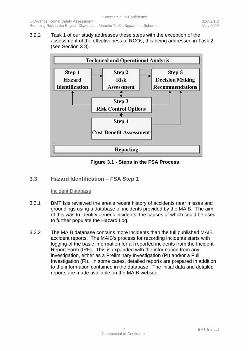
3.2 Task 1 FSA Steps 1 to 3
3.2.1 Steps 1 to 3 of the IMO’s FSA methodology (see Figure 3.1) involve:
a. Identifying hazards – Step 1;
b. Determining the risk levels – Step 2;
c. Identifying and assessing the effectiveness of RCOs – Step 3.
Commercial-In-Confidence UK/France Formal Safety Assessment: 31089/1.2 Reducing Risk in the English Channel/La Manche Traffic Separation Schemes May 2009
7 BMT Isis Ltd Commercial-In-Confidence
3.2.2 Task 1 of our study addresses these steps with the exception of the assessment of the effectiveness of RCOs, this being addressed in Task 2 (see Section 3.8).
Figure 3.1 - Steps in the FSA Process
3.3 Hazard Identification – FSA Step 1
Incident Database
3.3.1 BMT Isis reviewed the area’s recent history of accidents near misses and groundings using a database of incidents provided by the MAIB. The aim of this was to identify generic incidents, the causes of which could be used to further populate the Hazard Log.
3.3.2 The MAIB database contains more incidents than the full published MAIB accident reports. The MAIB’s process for recording incidents starts with logging of the basic information for all reported incidents from the Incident Report Form (IRF). This is expanded with the information from any investigation, either as a Preliminary Investigation (PI) and/or a Full Investigation (FI). In some cases, detailed reports are prepared in addition to the information contained in the database. The initial data and detailed reports are made available on the MAIB website.
Commercial-In-Confidence UK/France Formal Safety Assessment: 31089/1.2 Reducing Risk in the English Channel/La Manche Traffic Separation Schemes May 2009
8 BMT Isis Ltd Commercial-In-Confidence
3.3.3 In addition to information about the location of the incident and the type of incident, the MAIB incident database contains a text field that describes the incident and it was found that by analysing each description, incidents could be partitioned into:
a. crossing
b. overtaking
c. leaving one lane and crossing the other TSS lane
d. grounding
e. approach and passing
f. leaving and joining the TSS.
3.3.4 The database was searched for speed related incidents in the TSSs. It was found that speed was listed by the MAIB as an influencing factor for incidents in the TSSs, on only one occasion. Poor visibility was also a factor on this occasion.
Generic Incidents
3.3.5 From the above partitioning of the data, generic incidents were developed and the Hazard Log was populated with these generic incident descriptors and the causes as listed by the MAIB. From the causes, it was possible to develop RCOs and from the number of incidents the relative risk could be assessed.
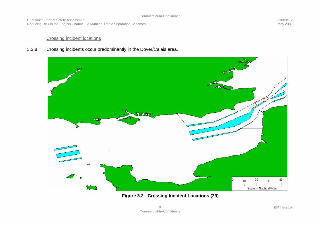
3.3.6 The incidents were also mapped using a Geographical Information System (GIS) to provide a good understanding of the geographical location of each type of incident. It is apparent from the incident maps that the majority of crossing incidents are, as expected, in the Dover/Calais area. It was interesting to find that the majority of overtaking incidents are adjacent to the inshore Traffic Zone boundary of the SW lane. There are also incidents involving approach and passing that are mainly involving fishing vessels. A sub-set of crossing incidents has also been found where vessels leave the TSS at a fixed location for a port, and in doing so, cross the opposite lane and are confronted by dense vessel traffic.
3.3.7 The GIS maps are shown below illustrating the above points, each showing (and providing supporting evidence for) crossing, overtaking, grounding and approach and passing incidents as reported by the MAIB as within the TSS (see Figure 3.2 to Figure 3.6).
Commercial-In-Confidence UK/France Formal Safety Assessment: 31089/1.2 Reducing Risk in the English Channel/La Manche Traffic Separation Schemes May 2009
9 BMT Isis Ltd Commercial-In-Confidence
Crossing incident locations
3.3.8 Crossing incidents occur predominantly in the Dover/Calais area.
Figure 3.2 - Crossing Incident Locations (29)
Commercial-In-Confidence UK/France Formal Safety Assessment: 31089/1.2 Reducing Risk in the English Channel/La Manche Traffic Separation Schemes May 2009
10 BMT Isis Ltd Commercial-In-Confidence
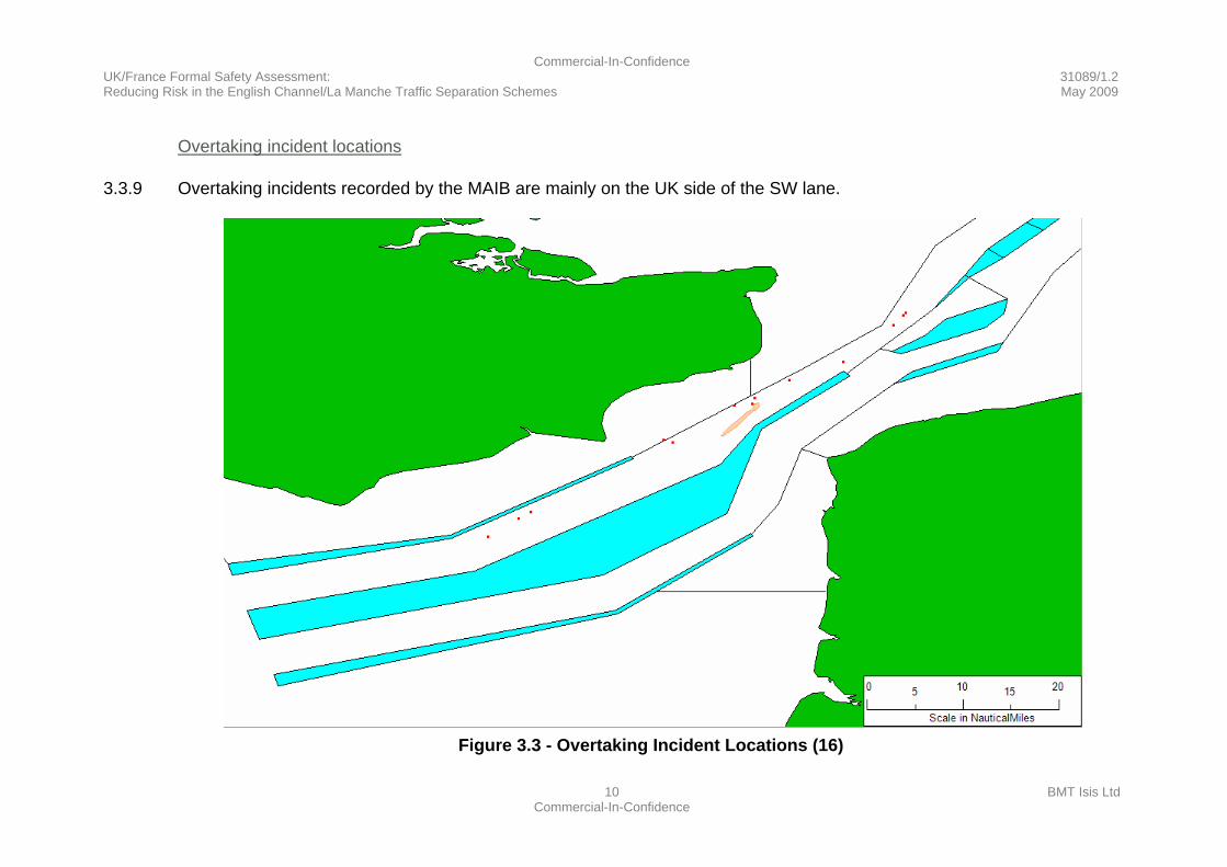
Overtaking incident locations
3.3.9 Overtaking incidents recorded by the MAIB are mainly on the UK side of the SW lane.
Figure 3.3 - Overtaking Incident Locations (16)
Commercial-In-Confidence UK/France Formal Safety Assessment: 31089/1.2 Reducing Risk in the English Channel/La Manche Traffic Separation Schemes May 2009
11 BMT Isis Ltd Commercial-In-Confidence
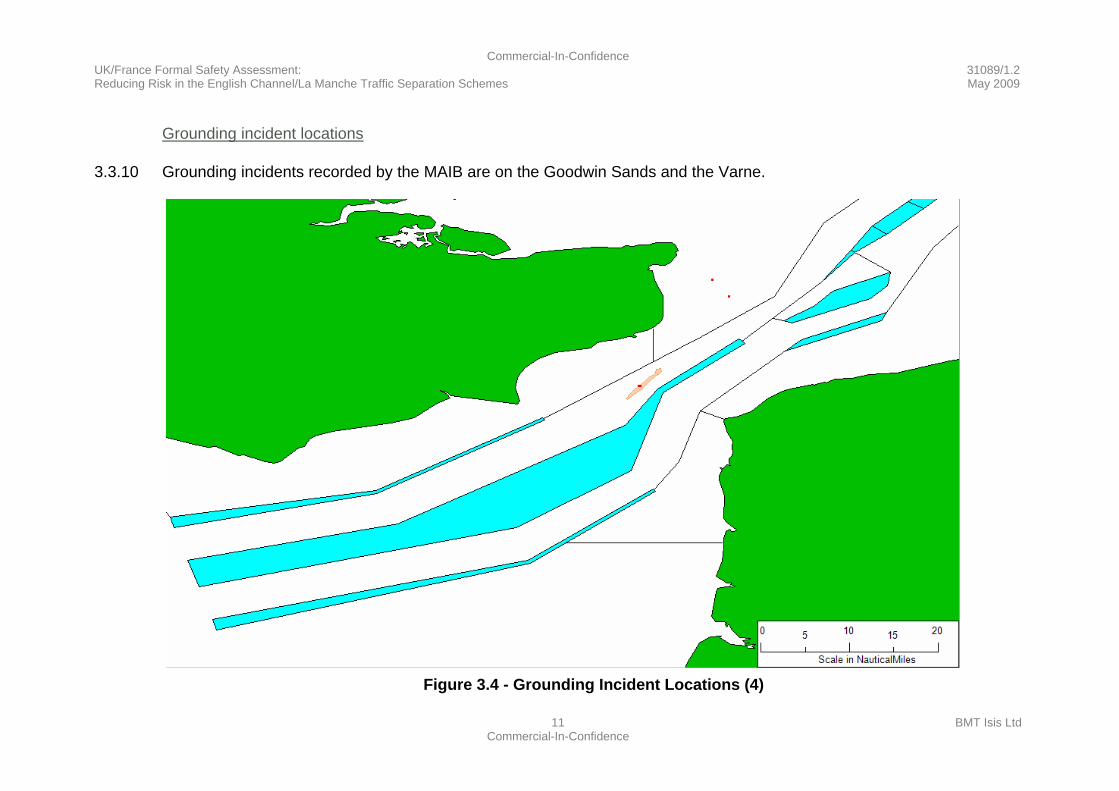
Grounding incident locations
3.3.10 Grounding incidents recorded by the MAIB are on the Goodwin Sands and the Varne.
Figure 3.4 - Grounding Incident Locations (4)
Commercial-In-Confidence UK/France Formal Safety Assessment: 31089/1.2 Reducing Risk in the English Channel/La Manche Traffic Separation Schemes May 2009
12 BMT Isis Ltd Commercial-In-Confidence
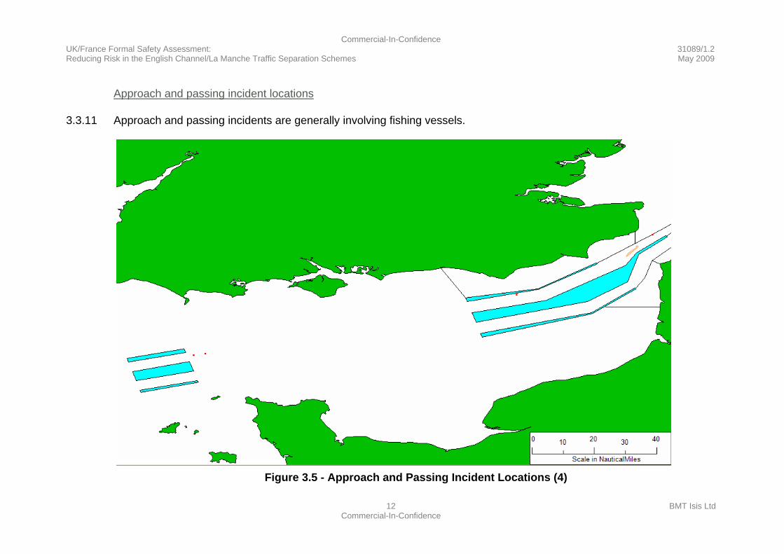
Approach and passing incident locations
3.3.11 Approach and passing incidents are generally involving fishing vessels.
Figure 3.5 - Approach and Passing Incident Locations (4)
Commercial-In-Confidence UK/France Formal Safety Assessment: 31089/1.2 Reducing Risk in the English Channel/La Manche Traffic Separation Schemes May 2009
13 BMT Isis Ltd Commercial-In-Confidence
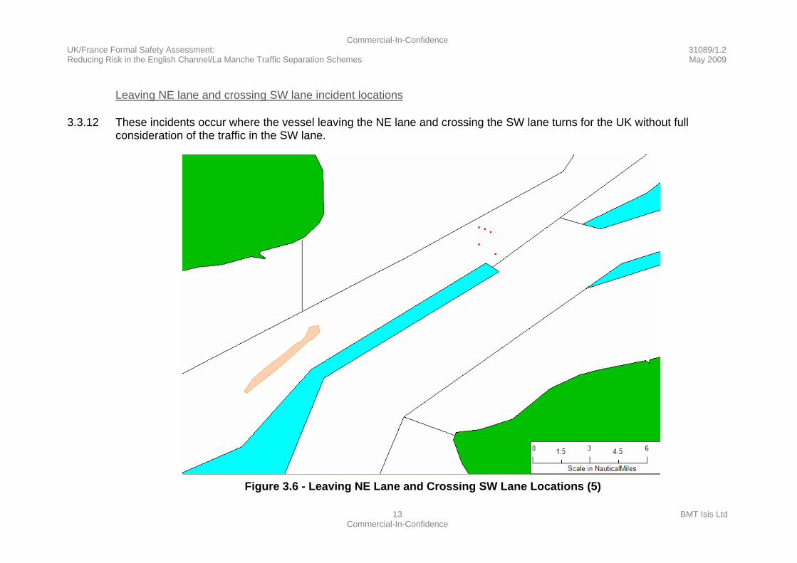
Leaving NE lane and crossing SW lane incident locations
3.3.12 These incidents occur where the vessel leaving the NE lane and crossing the SW lane turns for the UK without full consideration of the traffic in the SW lane.
Figure 3.6 - Leaving NE Lane and Crossing SW Lane Locations (5)
Commercial-In-Confidence UK/France Formal Safety Assessment: 31089/1.2 Reducing Risk in the English Channel/La Manche Traffic Separation Schemes May 2009
14 BMT Isis Ltd Commercial-In-Confidence
3.4 Determining Base Risk Levels – FSA Step 2
Incident Relative Frequency
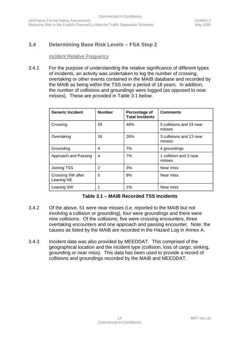
3.4.1 For the purpose of understanding the relative significance of different types of incidents, an activity was undertaken to log the number of crossing, overtaking or other events contained in the MAIB database and recorded by the MAIB as being within the TSS over a period of 18 years. In addition, the number of collisions and groundings were logged (as opposed to near misses). These are provided in Table 3.1 below.
Generic Incident Number Percentage of
Total Incidents Comments
Crossing 29 48% 5 collisions and 24 near misses
Overtaking 16 26% 3 collisions and 13 near misses
Grounding 4 7% 4 groundings
Approach and Passing 4 7% 1 collision and 3 near misses
Joining TSS 2 3% Near miss
Crossing SW after Leaving NE
5 8% Near miss
Leaving SW 1 1% Near miss
Table 3.1 – MAIB Recorded TSS Incidents
3.4.2 Of the above, 51 were near misses (i.e. reported to the MAIB but not involving a collision or grounding), four were groundings and there were nine collisions. Of the collisions, five were crossing encounters, three overtaking encounters and one approach and passing encounter. Note: the causes as listed by the MAIB are recorded in the Hazard Log in Annex A.
3.4.3 Incident data was also provided by MEEDDAT. This comprised of the geographical location and the incident type (collision, loss of cargo, sinking, grounding or near miss). This data has been used to provide a record of collisions and groundings recorded by the MAIB and MEEDDAT.

Commercial-In-Confidence UK/France Formal Safety Assessment: 31089/1.2 Reducing Risk in the English Channel/La Manche Traffic Separation Schemes May 2009
15 BMT Isis Ltd Commercial-In-Confidence
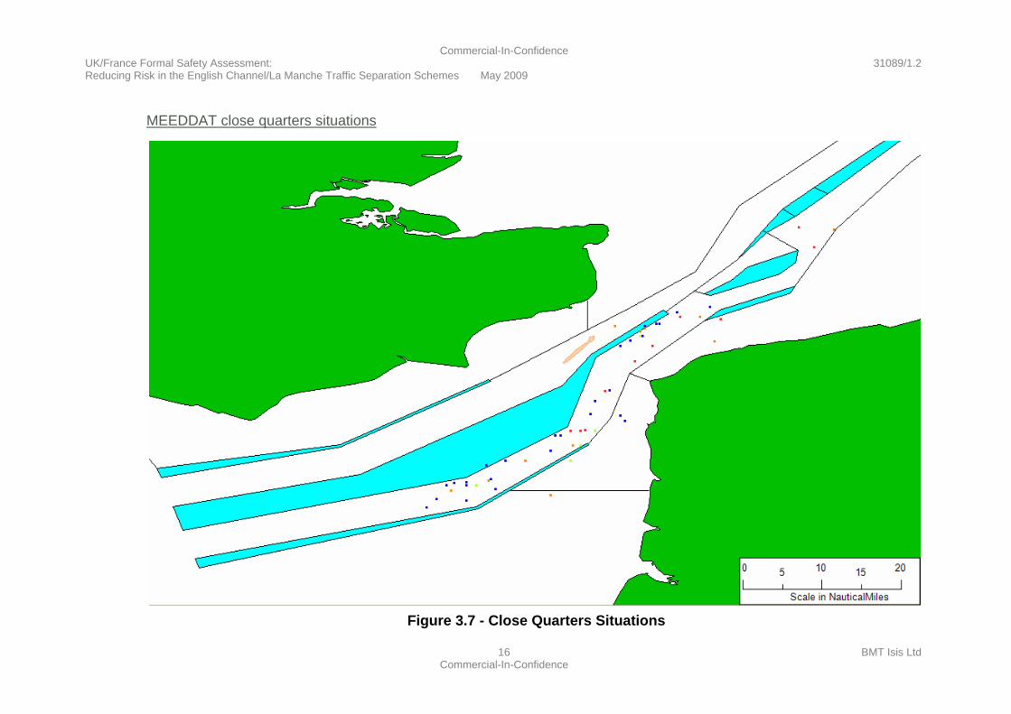
MEEDDAT Collisions and Groundings
3.4.4 MEEDDAT data (see Figure 3.7 and Figure 3.8) is for a period of 4 years and shows three groundings, six collisions and forty-eight close quarters situations. This indicates a greater annual number of incidents, collisions and groundings, than in the MAIB data. This may be a statistical cluster or for reasons of reporting or other factors. It would be necessary to collect data for a longer period and compare reporting processes to be able to assess if there are any significant differences in incident rates.
3.4.5 For the purposes of this study it has been assumed that, in the long term, MEEDDAT and MAIB recorded incident rates are similar. A pessimistic combined rate (allowing for increases in traffic density) of four collisions per year has been assumed for the purposes of the Cost Benefit Assessment.
Commercial-In-Confidence UK/France Formal Safety Assessment: 31089/1.2 Reducing Risk in the English Channel/La Manche Traffic Separation Schemes May 2009
16 BMT Isis Ltd Commercial-In-Confidence
MEEDDAT close quarters situations
Figure 3.7 - Close Quarters Situations

Commercial-In-Confidence UK/France Formal Safety Assessment: 31089/1.2 Reducing Risk in the English Channel/La Manche Traffic Separation Schemes May 2009
17 BMT Isis Ltd Commercial-In-Confidence
MEEDDAT collisions and groundings
Figure 3.8 - Collisions and Groundings

Commercial-In-Confidence UK/France Formal Safety Assessment: 31089/1.2 Reducing Risk in the English Channel/La Manche Traffic Separation Schemes May 2009
18 BMT Isis Ltd Commercial-In-Confidence
3.5 Identifying Risk Control Options – FSA Step 3
3.5.1 The probability of a collision or grounding can be considered to depend on the probability of being on a collision or grounding course multiplied by the probability that the vessel remains on a collision or grounding course.
3.5.2 RCOs can therefore be considered from the perspective of:
a. Reducing the probability of being on a collision or grounding course.
b. Increasing the probability of action to take the vessel off a collision or grounding course.
3.5.3 Causes for each hazard were first entered in the Hazard Log based on the MAIB investigation narrative. RCOs were then considered and developed.
3.5.4 The Hazard Log (see Annex A) includes the RCOs that have been developed to address the causes of each hazard. These RCOs are further discussed below. In summary, the main identified RCOs were:
a. An “additional pair of eyes” (effective for all encounters and grounding).
b. Increasing lateral separation (effective for overtaking incidents).
c. Speed management (effective for a small proportion of incidents).
Causes - General
3.5.5 Correspondingly, the main causes found are:
a. Watchkeeping is the most frequent cause recorded in the MAIB data. Also, the MAIB’s Bridge Watchkeeping Safety Study, July 2004 states that “two thirds of all vessels involved in collisions were not keeping a proper lookout”. The MCA has taken forward this issue and MGN 315 identifies and provides guidance.
b. Lateral bunching and frequent acceptance of a small Closest Point of Approach (CPA) by vessel crews.
3.5.6 In poor visibility, speed is recorded by the MAIB as an influencing factor in one case. The MAIB has not recorded speed as an influencing factor in other reported TSS incidents.
Commercial-In-Confidence UK/France Formal Safety Assessment: 31089/1.2 Reducing Risk in the English Channel/La Manche Traffic Separation Schemes May 2009
19 BMT Isis Ltd Commercial-In-Confidence
Visibility
3.5.7 Metocean data has shown that visibility reduces to less than 2 nm on 8% of days during the whole year as reported by the UK’s Met Office data, whereas MAIB data has shown that 14% of collisions occur when visibility is less than 2 nm. Consequently, the probability of a collision almost doubles when visibility is less than 2 nm (see Annex C). No specific identification of the reason for this doubling in accident rate has been identified.
Speed, Visibility and Small CPAs – the DIAMANTE and NORTHERN MERCHANT incident
3.5.8 The MAIB incident data in the area of interest does not have speed recorded as an influencing factor apart from one case in poor visibility, this being the DIAMANT and NORTHERN MERCHANT incident. A high-speed craft (DIAMANT) and a Ro-Ro Ferry (NORTHERN MERCHANT) were travelling at 29kts and 21kts in poor visibility. Speed was cited by the MAIB as a factor as was the acceptance of very close CPAs by the high-speed craft, particularly when relying on radar plots. It could be argued that too great a reliance was placed on the (radar) technology and the accuracy thereof, and a tacit understanding that the high speed craft would be undertaking the manoeuvre to avoid a close quarters situation.
3.6 Summary of Proposed Risk Control Options
3.6.1 The following RCOs were proposed for discussion and selection with the client at the 23rd April 2009 progress meeting.
Risk Control Options - Speed Management
3.6.2 In poor visibility, it is vital that speed and CPAs are appropriate to the conditions. It is proposed that vessels within the TSSs could be screened for proceeding at an appropriate speed with appropriate CPAs and contacted by VTS operators (allowing sufficient time for action) if CPAs are small or speeds excessive. This RCO would have the effect of increasing the probability of action to take the vessel off a collision or grounding course.
Risk Control Options - Increasing Lateral Separation
3.6.3 Vessels in the SW lane have a natural reluctance to use the route south of the Varne. The Inshore Traffic Zone boundary of the SW lane is the location of most overtaking incidents. It was proposed that overtaking incidents may be reduced by increasing lateral spacing of traffic, thus reducing the probability of vessels being on a collision course.
Commercial-In-Confidence UK/France Formal Safety Assessment: 31089/1.2 Reducing Risk in the English Channel/La Manche Traffic Separation Schemes May 2009
20 BMT Isis Ltd Commercial-In-Confidence
3.6.4 There is concern with any change that there may be secondary effects that negate the planned improvement. The concern with increasing lateral separation to reduce the number of overtaking incidents was that this may have some undesirable effect on crossing incidents.
3.6.5 To determine if there might be any secondary effects, a bridge visit was arranged while crossing from Dover to Calais on 31st March 2009. Discussion with a cross channel ferry master (Captain Andrew McCulloch, P&O Ferries,) has indicated that increasing lateral separation will make little difference (positive or negative) to vessels crossing the TSS because generally the route through the TSS would be plotted to avoid multiple course changes.
3.6.6 We proposed that the number of encounters (and the incident rate) could be reduced if better use is made of the waterspace particularly in the SW lane or the lane is widened. Methods of achieving this include:
a. Moving part of the Inshore Traffic Zone boundary of the SW lane further inshore. This would provide more room for vessels in the SW lane particularly near the Varne.
b. Designating the route south of the Varne a ‘deep-water’ route so traffic distribution is more balanced.
c. Requiring vessels to overtake with a minimum lateral (and longitudinal) clearance.
3.6.7 The RCO of increasing lateral separation would have the effect of reducing the probability of overtaking vessels being on a collision course.
3.6.8 Note: Moving the Inshore Traffic Zone boundary of the SW lane further inshore was subsequently eliminated from further consideration for a number of reasons;
a. TSS traffic potentially compromising the safe navigation of inshore traffic through forcing a smaller Inshore Traffic Zone
b. a significant number of wrecks in the vicinity
c. introduction of addition TSS turning points potentially encouraging bunching and navigational errors and
d. increased risks associated with bringing larger ships further inshore.
RCO - Increase Bridge Manning Levels for Congested TSSs
3.6.9 This RCO was addressed by the MAIB (reference: MAIB Bridge Watchkeeping Safety Study, July 2004). Their study recommended that a sole watchkeeper would only be appropriate where the risk is low. The MCA have taken this forward to the IMO (IMO STW40/WP4 5 Feb 2009 Annex 3 Para 2.7) and have published guidance (MGN 315).
Commercial-In-Confidence UK/France Formal Safety Assessment: 31089/1.2 Reducing Risk in the English Channel/La Manche Traffic Separation Schemes May 2009
21 BMT Isis Ltd Commercial-In-Confidence
RCO - Preprocessing VTS TSS Display
3.6.10 It may be possible to develop algorithms for inclusion in the automatic alarms for the VTS that provide VTS operators with an early warning of a possible collision or grounding. Care is needed when developing such algorithms that false positives (false alarms) and false negatives (failures to alarm) are minimised.
3.6.11 For grounding, the course data could be tested against the spread of acceptable course data for the vessel length and type.
3.6.12 For crossing and overtaking, the relative course data could be tested against the spread of acceptable relative course data for the vessel length and type.
3.6.13 It would be possible to develop algorithms and test those algorithms with AIS data records to determine the rates of false positives (false alarms) and false negatives (failures to alarm). It may also be necessary to promulgate to vessel operators the passing distances based on the distances in the alarm algorithms when developed.
RCO - VTS Operators Provide Proactive Information to Vessels
3.6.14 The above information could be provided to vessels by VTS operators provided that the communication is timely and the wording does not transfer responsibility for vessel navigation to the VTS operators.
3.6.15 For this to be effective for all vessels, it will be necessary to address the issues of crews unable to receive or understand this information because of, for example, language difficulties, receiving equipment not being active or because of crew members not being on the bridge or being asleep. Language difficulties could be addressed through the development of standard phrases which are included in the IMO’s Standard Marine Communication Phrases (SMCP).
3.7 Client Liaison following Task 1
3.7.1 Soon after the conclusion of Task 1, a progress meeting was held on 3rd March 2009 with the clients. At this meeting, the Hazard Log and the above RCOs were presented and discussed. The discussions included the feasibility, effectiveness, potential cost and the potential operational impact of the RCOs. At this meeting, the Hazard Log was accepted and some refinement of the RCOs was undertaken. These improved RCOs are described below and have been subject to an assessment of their effectiveness.

Commercial-In-Confidence UK/France Formal Safety Assessment: 31089/1.2 Reducing Risk in the English Channel/La Manche Traffic Separation Schemes May 2009
22 BMT Isis Ltd Commercial-In-Confidence
3.8 Task 2 FSA Step 3 continued - Assessing the Effectiveness of Risk Control Options - Summary
3.8.1 For each of the hazards listed in the Hazard Log the corresponding RCOs were agreed for taking forward in the study, as listed below. These were then assessed for their effectiveness.
Crossing Collision / Near Miss
3.8.2 Increase Bridge Manning – 90% of incidents involve the human element (data from Tavistock Institute of Human Behaviour). Recommending for example Watchkeeper, Helmsman and Lookout (or Master) being on the bridge could be counterproductive if they are fatigued (or this demand causes fatigue). There are also many other important factors such as alertness, training, capability, proficiency and independence in addition to the numbers on the bridge.
3.8.3 It is estimated that VTS operators providing a “second pair of eyes” could reduce incident probabilities by 50% in cases where a watchkeeper(s) is apparently unaware/asleep (approx 35% of incidents) and a succinct message will have minimal effect on workload in other cases. Note: the MAIB’s Bridge Watchkeeping Safety Study, July 2004 states that “two thirds of all vessels involved in collisions were not keeping a proper lookout”. In this study, cases have only been recorded where the watchkeeper was reported to be asleep or unaware of the other vessel. Cases where the watchkeeper was aware of the other vessel but could be considered not to be acting properly have not been included in our assessment. The effectiveness of this RCO is estimated to avoid 17.5% of all incidents (this RCO is effective for all encounter types).
3.8.4 Note: In all cases the “second pair of eyes” provided by VTS operators is in the provision of information to vessel crews so that the responsibility and liability of the VTS does not change.
3.8.5 Increasing lateral spacing in the SW lane - Regarding crossing encounters, analysis shows that this will not change the probability of an unimpeded crossing. As stated earlier, discussion with a cross channel ferry master has indicated that this will make little difference to vessels crossing the TSS because generally the route through the TSS would be plotted to avoid multiple course changes.
3.8.6 Introduce a new class of vessels constrained in manoeuvrability (e.g. high sided vessels in adverse wind and sea conditions) - the effectiveness of this RCO would depend on the behaviour of other vessels. The MAIB data available does not include incidents where a vessel was constrained by draught. Although thought to be beneficial, it is not possible to provide any evidence of effectiveness of this RCO.
Commercial-In-Confidence UK/France Formal Safety Assessment: 31089/1.2 Reducing Risk in the English Channel/La Manche Traffic Separation Schemes May 2009
23 BMT Isis Ltd Commercial-In-Confidence
3.8.7 Publication of Transgressors (e.g. on VTS web site) - the effectiveness of this measure depends on the ability of enhanced publication of transgressors to alter behaviour. Although thought to be beneficial, it is not possible to assess the effectiveness of this RCO. Existing publications covering elements of this RCO include the MAIB Safety Digest and the Confidential Hazardous Incident Reporting Programme (CHIRP).
Overtaking Collision / Near Miss
3.8.8 Again, it is estimated that VTS operators providing a “second pair of eyes” could reduce incident probabilities by 50% in cases where the watchkeeper is apparently unaware/asleep (approx 35%) and a succinct and timely message (from the VTS operators to the vessel or vessels) will have minimal effect on workload in other cases. The effectiveness of this RCO is estimated to avoid 17.5% of all incidents (this RCO is effective for all encounter types). An agreed passing geometry will need to be defined. This will in effect constitute a recommended passing distance.
3.8.9 Increasing lateral spacing in the SW lane - Analysis shows that this will reduce the probability of an overtaking incident by 50%. Overtaking incidents represent 26% of all MAIB incidents. The effectiveness of this RCO was analysed and shown to avoid 50% of SW lane overtaking incidents, representing 13% of all MAIB incidents.
3.8.10 Ban slow (small speed differential) overtaking with small separation – the need for this reduces if other RCOs result in lateral spacing increases.
Leaving NE and Crossing SW Collision / Near Miss
3.8.11 Widening the crossing point – It is difficult to quantify the benefit but we estimate that the number of these incidents (8% of all incidents) could reduce by 50% if all crossing vessels wait until SW lane crossing will be unimpeded. The effectiveness of this RCO is estimated to avoid 50% of leaving/crossing incidents, representing 4% of all MAIB incidents.
3.8.12 Again, VTS operators providing a “second pair of eyes” (providing information only) could reduce incident probabilities in cases where the watchkeeper is apparently unaware/asleep (approx 35%) and a succinct message will have minimal effect on workload in other cases. The effectiveness of this RCO is estimated to avoid 17.5% of all incidents (this RCO is effective for all encounter types).
3.8.13 Note: It might also be argued that in this case, where a vessel is crossing another TSS lane, that the bridge team should be more committed to situational awareness.

Commercial-In-Confidence UK/France Formal Safety Assessment: 31089/1.2 Reducing Risk in the English Channel/La Manche Traffic Separation Schemes May 2009
24 BMT Isis Ltd Commercial-In-Confidence
Grounding
3.8.14 Training in the use of electronic charting and equipment - this already exists but is clearly not working consistently based on the LT CORTESIA and LOWLANDS MAINE incidents. It is too easy for displays and alarms to be set such that the equipment becomes ineffective. It is not possible to meaningfully estimate to what extent additional training would improve this situation.
3.8.15 Note: In the LT CORTESIA grounding, the MAIB recorded that equipment alarms were ignored and in the LOWLANDS MAINE grounding the MAIB recommended training to include navigational equipment.
Approach and Passing General
3.8.16 These encounters mainly involve fishing vessels and the planned introduction of AIS transponders on fishing vessels will reduce the incident probability. The implementation of this RCO is already in progress (see References: Amending VTMD Directive). We estimate that incident probability could be reduced by 50%. The effectiveness of this RCO is estimated to avoid 50% of approach and passing incidents, representing 3% of all incidents.
Approach and Passing in Poor Visibility
3.8.17 One collision has occurred in fog and at speed but there were no MAIB recorded near misses for the TSSs where speed has been listed by the MAIB as a cause. Reliance on radar, acceptance of a 3 cables CPA and speed were the MAIB listed causes. It is estimated that targeted VTS communication may reduce the probability of such incidents by 50%. The effectiveness of this RCO is estimated to avoid 50% of approach and passing in poor visibility incidents representing 1% of all incidents.
3.8.18 Note that in general, by correlation, incidents are twice as likely when visibility is < 2 nm.
Commercial-In-Confidence UK/France Formal Safety Assessment: 31089/1.2 Reducing Risk in the English Channel/La Manche Traffic Separation Schemes May 2009
25 BMT Isis Ltd Commercial-In-Confidence
3.9 Analysis associated with Assessing the Effectiveness of Risk Control Options
RCO - “A Second Pair of Eyes” (effective for all encounter types)
3.9.1 It is estimated that VTS operators providing a “second pair of eyes” could reduce incident probabilities by 50% in cases where the watchkeeper is apparently unaware/asleep (approx 35%) and a succinct message (from VTS operators to the vessel or vessels involved) will have minimal effect on crew workload in other cases. The reasoning for expecting to reduce the number of incidents by 50% rather that 100% is the assumption that the VTS operator would detect 70% of potential incidents and that the vessel would respond appropriately in 70% of cases.
RCO - Lateral Separation (effective for overtaking)
3.9.2 AIS data analysis has been undertaken into assessment of the benefit of increasing the lateral separation of the traffic by encouraging more vessels to pass south of the Varne. This has involved a number of AIS data processing activities, as described below.
AIS Processing to assess similarity of NE and SW traffic volumes
3.9.3 Prior to assessing the benefit of lateral separation, an understanding was required of the number of vessels travelling NE and SW.
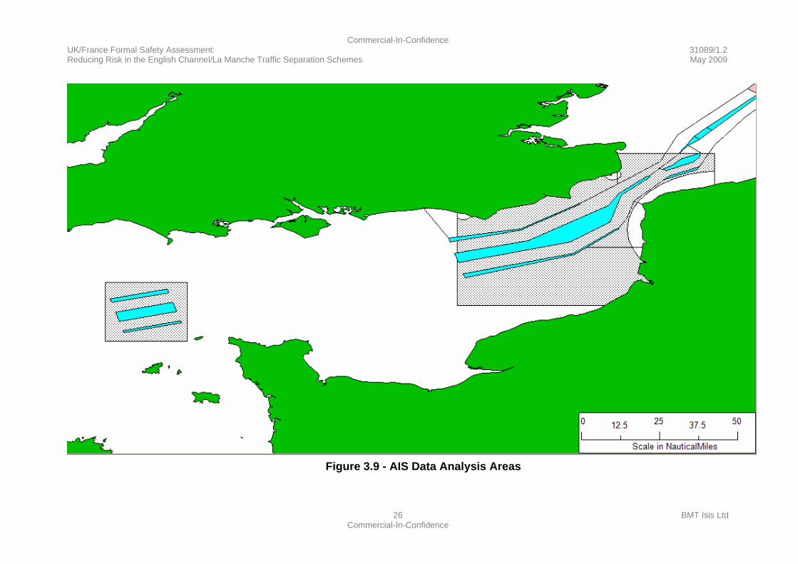
3.9.4 The AIS data was filtered to identify the number of unique vessels within the selected area of interest (see Figure 3.9). In addition, the approximate start location and end location of each vessel were found. Using this information, it was possible to imply the travel direction for each vessel in the area.
Commercial-In-Confidence UK/France Formal Safety Assessment: 31089/1.2 Reducing Risk in the English Channel/La Manche Traffic Separation Schemes May 2009
26 BMT Isis Ltd Commercial-In-Confidence
Figure 3.9 - AIS Data Analysis Areas
Commercial-In-Confidence UK/France Formal Safety Assessment: 31089/1.2 Reducing Risk in the English Channel/La Manche Traffic Separation Schemes May 2009
27 BMT Isis Ltd Commercial-In-Confidence
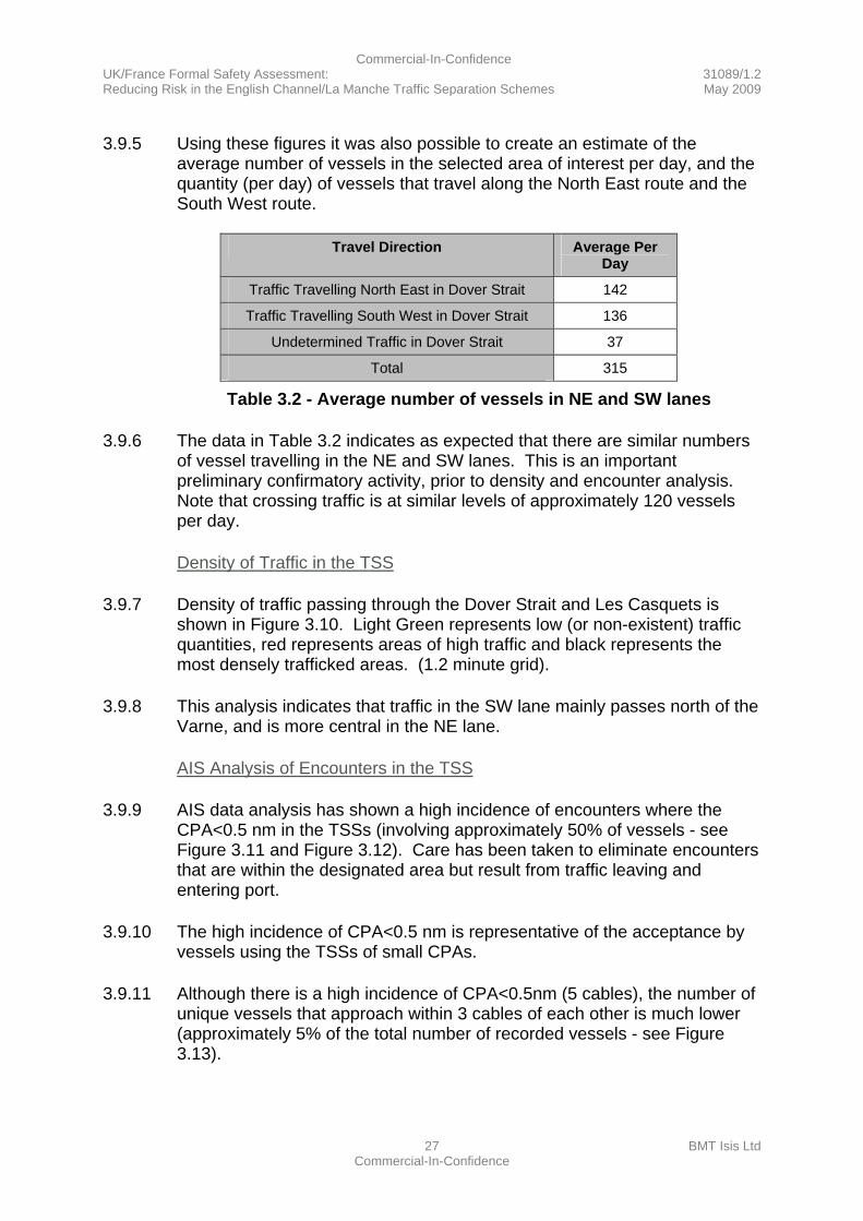
3.9.5 Using these figures it was also possible to create an estimate of the average number of vessels in the selected area of interest per day, and the quantity (per day) of vessels that travel along the North East route and the South West route.
Travel Direction Average Per
Day
Traffic Travelling North East in Dover Strait 142
Traffic Travelling South West in Dover Strait 136
Undetermined Traffic in Dover Strait 37
Total 315
Table 3.2 - Average number of vessels in NE and SW lanes
3.9.6 The data in Table 3.2 indicates as expected that there are similar numbers of vessel travelling in the NE and SW lanes. This is an important preliminary confirmatory activity, prior to density and encounter analysis. Note that crossing traffic is at similar levels of approximately 120 vessels per day.
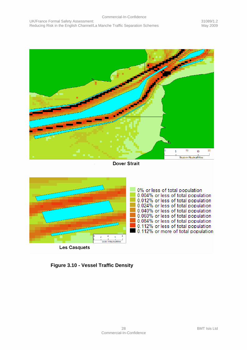
Density of Traffic in the TSS
3.9.7 Density of traffic passing through the Dover Strait and Les Casquets is shown in Figure 3.10. Light Green represents low (or non-existent) traffic quantities, red represents areas of high traffic and black represents the most densely trafficked areas. (1.2 minute grid).
3.9.8 This analysis indicates that traffic in the SW lane mainly passes north of the Varne, and is more central in the NE lane.
AIS Analysis of Encounters in the TSS
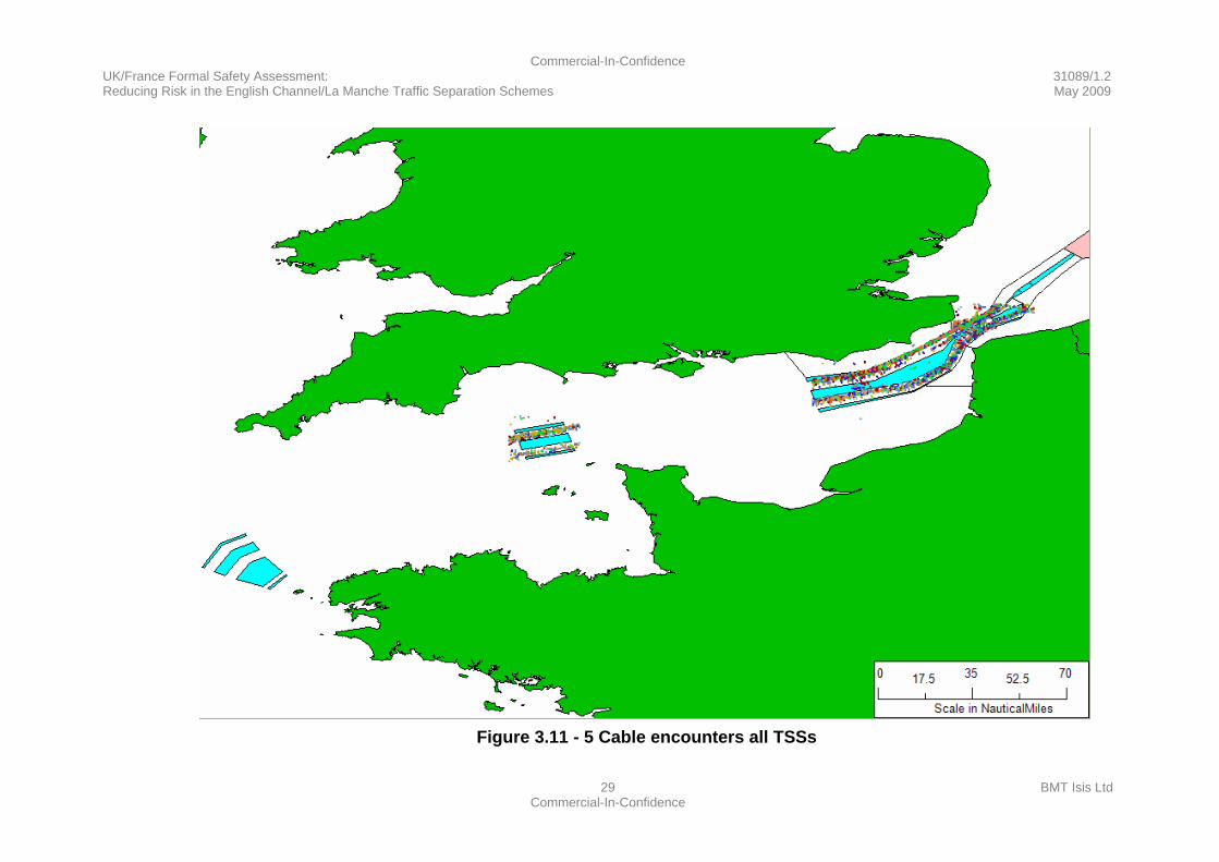
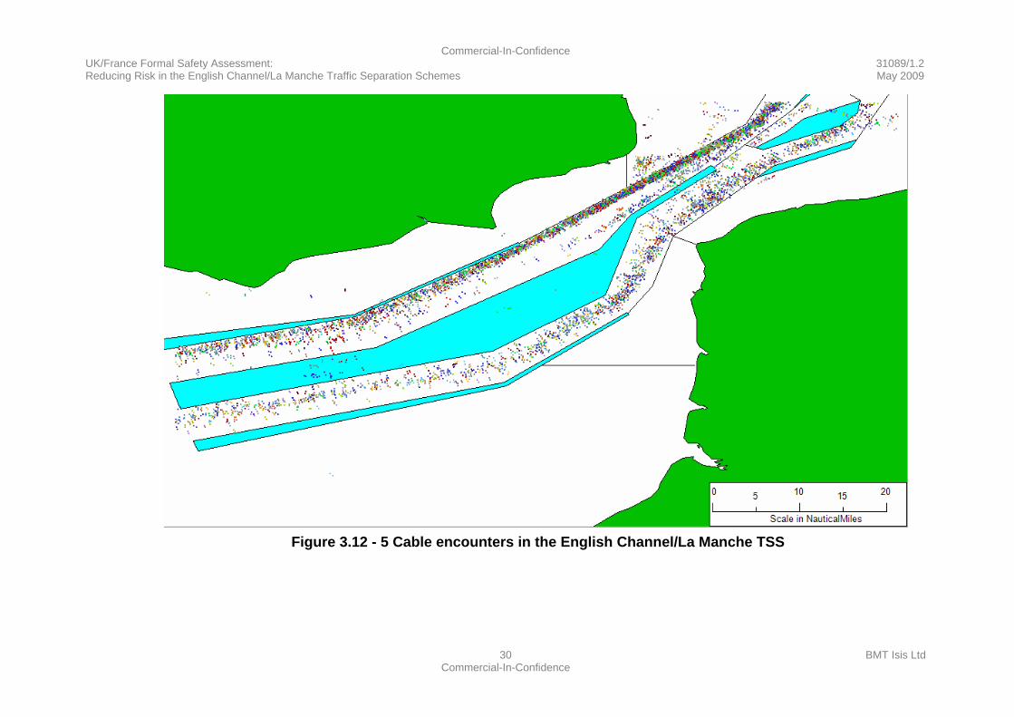
3.9.9 AIS data analysis has shown a high incidence of encounters where the CPA<0.5 nm in the TSSs (involving approximately 50% of vessels - see Figure 3.11 and Figure 3.12). Care has been taken to eliminate encounters that are within the designated area but result from traffic leaving and entering port.
3.9.10 The high incidence of CPA<0.5 nm is representative of the acceptance by vessels using the TSSs of small CPAs.
3.9.11 Although there is a high incidence of CPA<0.5nm (5 cables), the number of unique vessels that approach within 3 cables of each other is much lower (approximately 5% of the total number of recorded vessels - see Figure 3.13).
Commercial-In-Confidence UK/France Formal Safety Assessment: 31089/1.2 Reducing Risk in the English Channel/La Manche Traffic Separation Schemes May 2009
28 BMT Isis Ltd Commercial-In-Confidence
Figure 3.10 - Vessel Traffic Density
Commercial-In-Confidence UK/France Formal Safety Assessment: 31089/1.2 Reducing Risk in the English Channel/La Manche Traffic Separation Schemes May 2009
29 BMT Isis Ltd Commercial-In-Confidence
Figure 3.11 - 5 Cable encounters all TSSs
Commercial-In-Confidence UK/France Formal Safety Assessment: 31089/1.2 Reducing Risk in the English Channel/La Manche Traffic Separation Schemes May 2009
30 BMT Isis Ltd Commercial-In-Confidence
Figure 3.12 - 5 Cable encounters in the English Channel/La Manche TSS
Commercial-In-Confidence UK/France Formal Safety Assessment: 31089/1.2 Reducing Risk in the English Channel/La Manche Traffic Separation Schemes May 2009
31 BMT Isis Ltd Commercial-In-Confidence
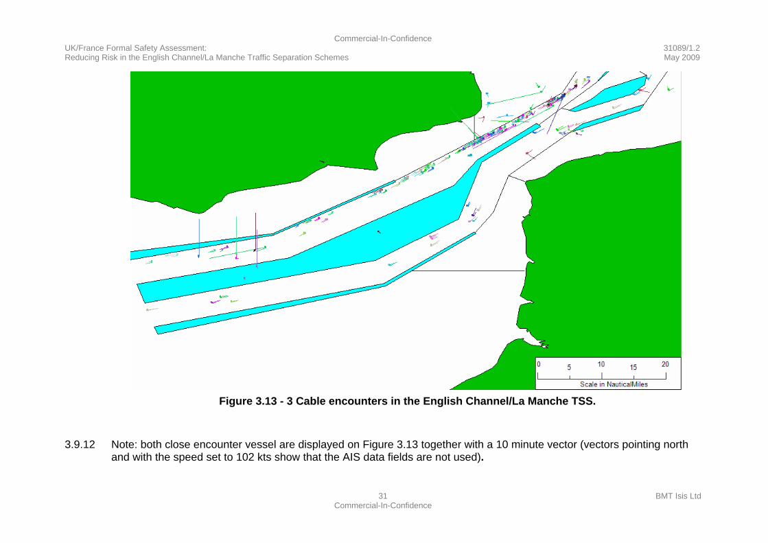
Figure 3.13 - 3 Cable encounters in the English Channel/La Manche TSS.
3.9.12 Note: both close encounter vessel are displayed on Figure 3.13 together with a 10 minute vector (vectors pointing north and with the speed set to 102 kts show that the AIS data fields are not used).
Commercial-In-Confidence UK/France Formal Safety Assessment: 31089/1.2 Reducing Risk in the English Channel/La Manche Traffic Separation Schemes May 2009
32 BMT Isis Ltd Commercial-In-Confidence
Congestion
3.9.13 AIS data has shown that congested areas cause vessels to travel closer to each other than under normal conditions, giving less room for error in the event of unforeseen circumstances.
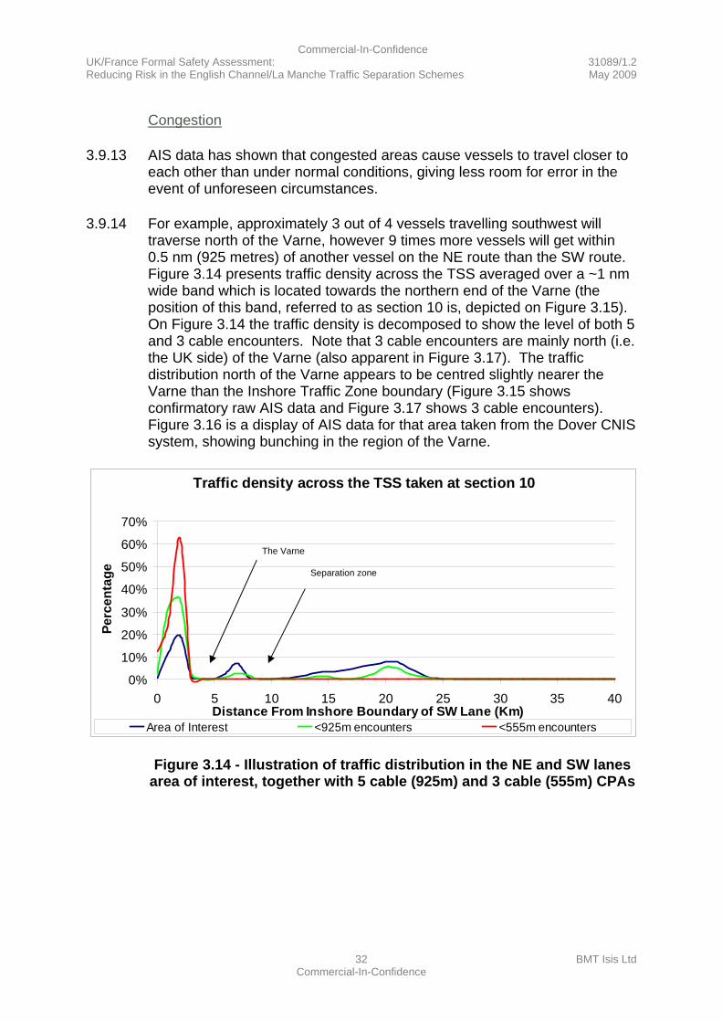
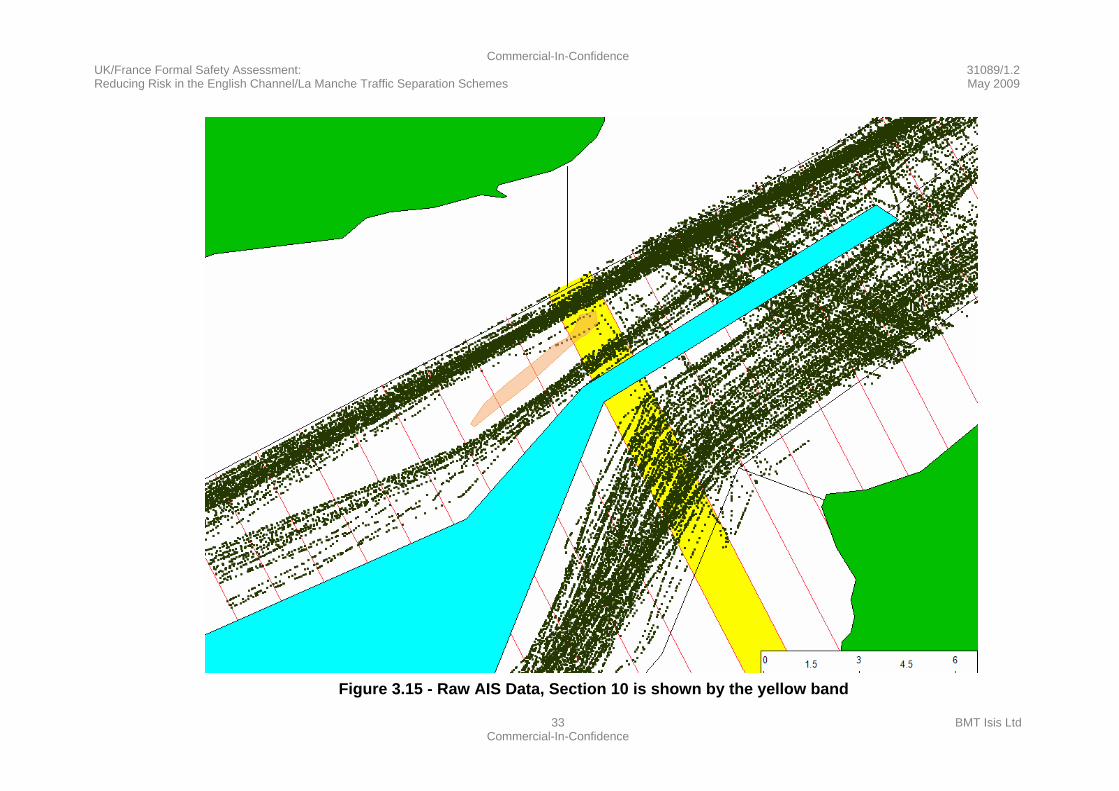
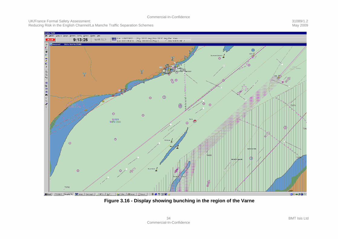
3.9.14 For example, approximately 3 out of 4 vessels travelling southwest will traverse north of the Varne, however 9 times more vessels will get within 0.5 nm (925 metres) of another vessel on the NE route than the SW route. Figure 3.14 presents traffic density across the TSS averaged over a ~1 nm wide band which is located towards the northern end of the Varne (the position of this band, referred to as section 10 is, depicted on Figure 3.15). On Figure 3.14 the traffic density is decomposed to show the level of both 5 and 3 cable encounters. Note that 3 cable encounters are mainly north (i.e. the UK side) of the Varne (also apparent in Figure 3.17). The traffic distribution north of the Varne appears to be centred slightly nearer the Varne than the Inshore Traffic Zone boundary (Figure 3.15 shows confirmatory raw AIS data and Figure 3.17 shows 3 cable encounters). Figure 3.16 is a display of AIS data for that area taken from the Dover CNIS system, showing bunching in the region of the Varne.
Figure 3.14 - Illustration of traffic distribution in the NE and SW lanes
area of interest, together with 5 cable (925m) and 3 cable (555m) CPAs
Traffic density across the TSS taken at section 10
0%
10%
20%
30%
40%
50%
60%
70%
0 5 10 15 20 25 30 35 40Distance From Inshore Boundary of SW Lane (Km)
Perc
enta
ge
Area of Interest <925m encounters <555m encounters
The Varne
Separation zone
Commercial-In-Confidence UK/France Formal Safety Assessment: 31089/1.2 Reducing Risk in the English Channel/La Manche Traffic Separation Schemes May 2009
33 BMT Isis Ltd Commercial-In-Confidence
Figure 3.15 - Raw AIS Data, Section 10 is shown by the yellow band
Commercial-In-Confidence UK/France Formal Safety Assessment: 31089/1.2 Reducing Risk in the English Channel/La Manche Traffic Separation Schemes May 2009
34 BMT Isis Ltd Commercial-In-Confidence
Figure 3.16 - Display showing bunching in the region of the Varne

Commercial-In-Confidence UK/France Formal Safety Assessment: 31089/1.2 Reducing Risk in the English Channel/La Manche Traffic Separation Schemes May 2009
35 BMT Isis Ltd Commercial-In-Confidence
Figure 3.17 - 3 Cable encounters Varne region.
3.9.15 Note: both close encounter vessels are displayed on Figure 3.17 together with a 10 minute vector (vectors pointing north and with the speed set to 102 kts show that the AIS data fields are not used).
Commercial-In-Confidence UK/France Formal Safety Assessment: 31089/1.2 Reducing Risk in the English Channel/La Manche Traffic Separation Schemes May 2009
36 BMT Isis Ltd Commercial-In-Confidence
3.9.16 Splitting the traffic either side of the Varne by using a filter of a speed of 13 kts, a length of 130 metres or a draught of 7 metres is expected to reduce the overall number of overtaking encounters by between 50% to 55%. Routing tankers south of the Varne would reduce overtaking encounters by approximately 30% This analysis was conducted based on the AIS data provided (see Annex D). There were concerns that draught would not be a good discriminator because of variations with loading and that speed discrimination may change behaviours (and it was noted that speed broadly correlates with length).
3.9.17 Of these options, it is suggested that including on charts the recommendation that vessels over 130 metres are to travel to the south of the Varne is the most practicable.
RCO – Widening Crossing Point (effective for vessels leaving NE lane and crossing SW lane)
3.9.18 By widening the zone where vessels are tending to cross in the region of the MPC (by better chart marking), it is estimated that the number of incidents could reduce by 50%. This is based on an assumption that 50% of vessels would not use the additional space.
RCO – AIS for Fishing Vessels (effective for approach and passing incidents)
3.9.19 These encounters mainly involve fishing vessels and AIS on fishing vessels will reduce this incident probability. This RCO is already in progress. It is estimated that incident probability will reduce by 50%. The reasoning for expecting to reduce the number of incidents by 50% rather that 100% is the assumption that the AIS will only be operational in 50% of fishing vessels, due to expectations of operational misuse in 50% of fishing vessels.
RCO “A Second Pair of Eyes” (effective for approach and Passing in Poor Visibility)
3.9.20 One collision has occurred in fog and at speed. MAIB listed causes for the collision were reliance on radar and acceptance of a 3 cables CPA and speed were the MAIB listed causes. It is estimated that targeted VTS communication, alerting vessel crews where speed is excessive or CPAs are small in poor visibility, may reduce the probability of such incidents by 50%.
3.9.21 The reasoning for expecting to reduce the number of incidents by 50% rather than 100%, is the assumption that the VTS operator would detect 70% of potential incidents and that the vessel would respond appropriately in 70% of cases. It is assumed that false positive and false negative alarm rates can be balanced to achieve 70% detection and that language and alertness can be addressed to achieve a 70% vessel response.
Commercial-In-Confidence UK/France Formal Safety Assessment: 31089/1.2 Reducing Risk in the English Channel/La Manche Traffic Separation Schemes May 2009
37 BMT Isis Ltd Commercial-In-Confidence
3.9.22 The above assessments of effectiveness have been used together with the incident frequencies in the cost benefit assessment provided in Annex B.
3.10 Task 3 FSA Step 4 - Broad Orders of Cost and CBA
3.10.1 Annex B provides an assessment of the costs of an incident, the costs of the main RCOs and an assessment of the cost/benefit ratio.
Collision Costs - general
3.10.2 Oil spill and loss of life data has been assessed. The oil spill data has been divided into low frequency but large spills, and smaller more frequent spills.
3.10.3 This data has enabled the current cost associated with large and small spills and loss of life in the TSS to be assessed (see Annex B).
CBA
3.10.4 For the main RCOs the broad order of costs have been estimated. These costs have been compared with the benefit from the risk reduction that the RCOs would deliver. These benefits will combine the reduction in incident probability with the costs of the consequences to the environment, commerce and life. A CBA spreadsheet has been constructed including the costs, benefits, time to implement and the cost/benefit ratio. In some cases, costs are mainly incurred by vessel operators and in other cases by VTS operators.
3.10.5 Note that the cost of an accident/incident analysis used data based upon the US dollar. A conversion from US dollars to UK pounds has used the current prevailing rate. It should be noted therefore that the cost benefit assessment ratio could fluctuate due to changing exchange rates.
3.10.6 It should also be noted that cost data has been either collected from available industry sources (see Annex B) or best estimates made and should be considered as budgetary.
3.10.7 RCOs have been separated into those that can be implemented in the short term and those that may require a longer timescale for implementation.
Findings
3.10.8 Annex B shows the cost benefit ratio for all RCOs. The most beneficial are summarised below.
a. The Risk Control Option of recommending the route south of the Varne for vessels over 130 metres is highly cost beneficial with the cost representing only 1.4% of the benefit.

Commercial-In-Confidence UK/France Formal Safety Assessment: 31089/1.2 Reducing Risk in the English Channel/La Manche Traffic Separation Schemes May 2009
38 BMT Isis Ltd Commercial-In-Confidence
b. It has been found that the Risk Control Option of the VTS operators providing a “second pair of eyes” is cost beneficial with the cost representing only 7% of the benefit. This RCO will benefit all encounters including where vessels are travelling at excessive speed in poor visibility. The strength of this RCO is in the independence of the VTS operators and systems from those on vessels.
c. Clarifying the extent of the crossing zone on the chart for when leaving the NE lane and crossing the SW lane is also cost beneficial with the cost representing only 4% of the benefit.
3.10.9 For some RCOs, the cost outweighs the benefit. These are:
a. Increasing bridge manning.
b. Compulsory pilotage.
3.11 Task 4 FSA Step 5 -Decision Making Recommendations
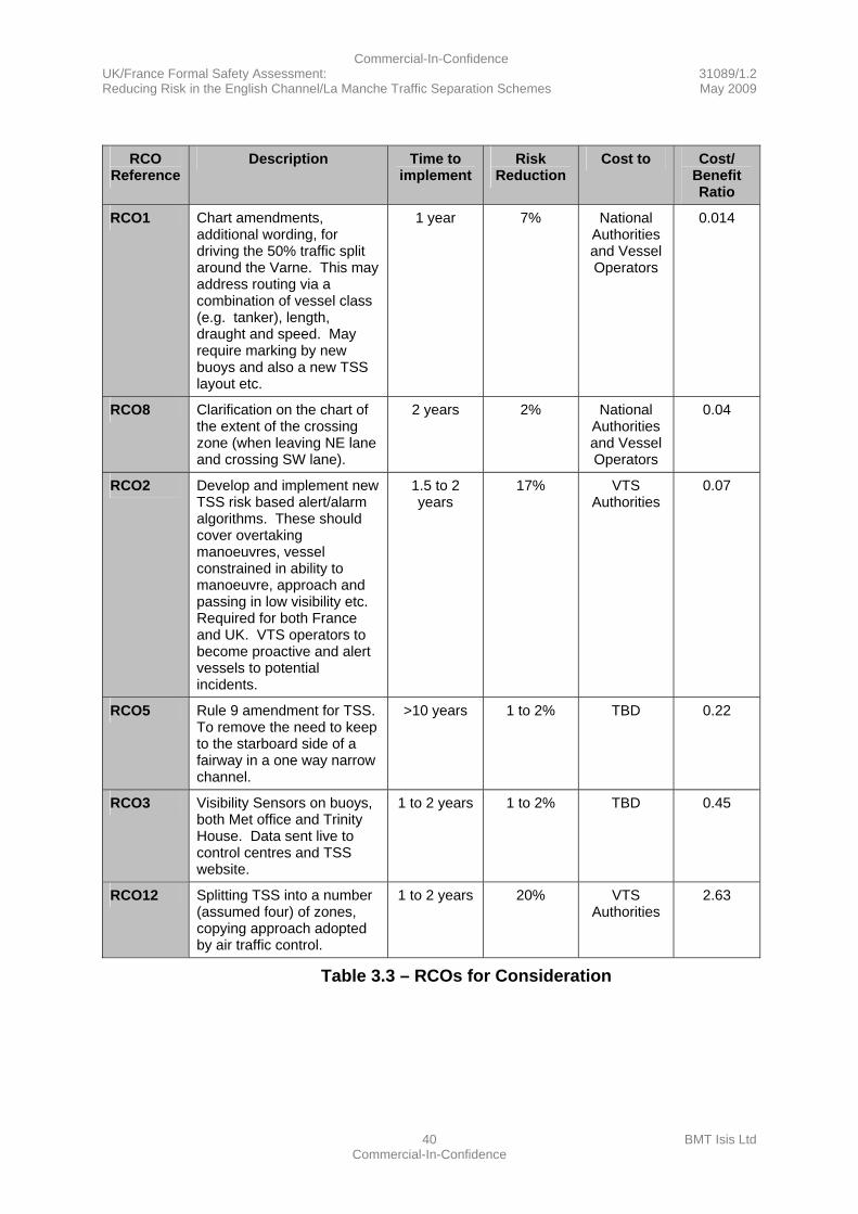
3.11.1 Table 3.3 – RCOs for Consideration summarises the RCOs in all cases where the benefit approximates to or exceeds the cost together with the affected entity (i.e. where the cost falls – e.g. for VTS authorities or vessel operators), estimated timescales for implementation, risk reduction (% incidents or accidents avoided) and cost effectiveness. It is recommended that these RCOs be considered by the MCA and MEEDDAT as suitable for implementation.
3.11.2 The RCOs in Table 3.3 below address the hazards identified in the Hazard Log (see Annex A) and are expected to reduce risk of incidents and accidents by up to 20%.
3.11.3 It should be noted that the effectiveness of the RCO to distribute traffic around the Varne has been based on mathematical analysis of the reduction in encounters.
3.11.4 The effectiveness of the RCO where the VTS operators provide a “second pair of eyes” is based on a deliberately pessimistic estimate of effectiveness. In this RCO it has been estimated that the VTS operator would detect 70% of potential incidents and that the vessel would respond appropriately in 70% of cases. For these estimates to remain valid requires a 70% success rate for VTS collision and grounding alarms and for the alertness and comprehension of vessel crews to be such that they respond appropriately in 70% of cases.
3.11.5 The first three RCOs 1, 8 and 2 are highly cost beneficial and can be implemented in the short term, RCO 5 being slightly less cost beneficial and requiring a longer timescale.
Commercial-In-Confidence UK/France Formal Safety Assessment: 31089/1.2 Reducing Risk in the English Channel/La Manche Traffic Separation Schemes May 2009
39 BMT Isis Ltd Commercial-In-Confidence
3.11.6 For RCOs 3 and 12 the costs are of similar order to the benefit valuation. Given the approximately break-even nature of these RCOs it would be better to spend the money on the RCOs to avoid an incident than spend a similar order of magnitude on clean-up or other costs. RCO 12 can be considered a more intense version of RCO1.
3.11.7 For the RCOs Compulsory Pilotage and Increasing Bridge Manning, the costs outweigh the benefits by 60 and 120 times respectively (see Annex B) with lengthy timescales for implementation. For these reasons these RCOs have not been included in Table 3.3 below. It should be noted that these costs would fall similarly across the industry so would not change the competitiveness between vessel operators. However, the effect would be to reduce the competitiveness of sea transport compared to other modes of transport. It is suggested that these options should remain open for further consideration in the future.
Commercial-In-Confidence UK/France Formal Safety Assessment: 31089/1.2 Reducing Risk in the English Channel/La Manche Traffic Separation Schemes May 2009
40 BMT Isis Ltd Commercial-In-Confidence
RCO
Reference Description Time to
implement Risk
Reduction Cost to Cost/
Benefit Ratio
RCO1 Chart amendments, additional wording, for driving the 50% traffic split around the Varne. This may address routing via a combination of vessel class (e.g. tanker), length, draught and speed. May require marking by new buoys and also a new TSS layout etc.
1 year 7% National Authorities and Vessel Operators
0.014
RCO8 Clarification on the chart of the extent of the crossing zone (when leaving NE lane and crossing SW lane).
2 years 2% National Authorities and Vessel Operators
0.04
RCO2 Develop and implement new TSS risk based alert/alarm algorithms. These should cover overtaking manoeuvres, vessel constrained in ability to manoeuvre, approach and passing in low visibility etc. Required for both France and UK. VTS operators to become proactive and alert vessels to potential incidents.
1.5 to 2 years
17% VTS Authorities
0.07
RCO5 Rule 9 amendment for TSS. To remove the need to keep to the starboard side of a fairway in a one way narrow channel.
>10 years 1 to 2% TBD 0.22
RCO3 Visibility Sensors on buoys, both Met office and Trinity House. Data sent live to control centres and TSS website.
1 to 2 years 1 to 2% TBD 0.45
RCO12 Splitting TSS into a number (assumed four) of zones, copying approach adopted by air traffic control.
1 to 2 years 20% VTS Authorities
2.63
Table 3.3 – RCOs for Consideration

Commercial-In-Confidence UK/France Formal Safety Assessment: 31089/1.2 Reducing Risk in the English Channel/La Manche Traffic Separation Schemes May 2009
41 BMT Isis Ltd Commercial-In-Confidence
3.12 Further Points of Interest
3.12.1 During the course of the study a few interesting points have emerged that are loosely related to the study, and worthy of further future consideration.
3.12.2 It appears from an initial examination that vessels that do not have heading and speed set in their AIS transmissions are more likely to be involved in close encounters than the average. This may simply be correlated with the vessel size or there may be other factors. In addition, completion of fields that require manual entry may also indicate the level of time pressure on the crew or other factors that could affect safety.
3.12.3 The strength of our RCO of the VTS operator providing a “second pair of eyes” is in the independence of the VTS operators and systems from those on vessels. There is an obvious point arising that despite the modern navigation aids that are available that could assure safe passage, it remains possible for perfectly sound vessels to collide or to run aground. Clearly something is not working as intended despite best efforts, e.g. Electronic Chart Display and Information System (ECDIS) data, displays and training are all required and active yet ECDIS equipped vessels still ground. It may be that a study to fully understand how these incidents happen and action such as refinements to training systems and perhaps standardisation of data, displays and defaults or perhaps maintaining currency in using fall-back systems may help to avoid the avoidable. Note that: in the LT CORTESIA grounding, the MAIB recorded that equipment alarms were ignored and in the LOWLANDS MAINE grounding the MAIB recommended training to include navigational equipment.
3.12.4 It is apparent that the modern bridge can be isolated from external sound and the use of technology to relay external sounds, perhaps tuned to sound signal and engine noise frequencies may reduce that isolation and possibly enhance directionality. This would support compliance with SOLAS.
3.12.5 It has been suggested by mariners that are familiar with the area of interest that the desire to stay in mobile phone network coverage may be encouraging passage planners to select a route north of the Varne. Improving mobile phone network coverage across the TSS zone may have an impact if this is a factor in passage planning (requires further study to validate).
3.12.6 The study has not been required to investigate the funding mechanism for the RCOs. Nevertheless, in the course of the study, it has been suggested that a levy on vessels using the TSSs could provide a means of additional funding that would deliver improvements in safety.
Commercial-In-Confidence UK/France Formal Safety Assessment: 31089/1.2 Reducing Risk in the English Channel/La Manche Traffic Separation Schemes May 2009
42 BMT Isis Ltd Commercial-In-Confidence
3.13 Commentary on Other Initiatives
3.13.1 It is interesting to note that there are other initiatives that relate to the issues addressed in this study.
3.13.2 The MAIB paper regarding bridge watchkeeping (and other related work) has been mentioned previously and this has highlighted what is clearly a major issue. In this FSA study we have recognised the same issue and the methodology has provided the same and some alternative RCOs to deal with this issue, these alternatives being more cost effective and faster to implement than bridge team enhancement.
3.13.3 There is a draft IMO recommendation on recommended pilotage prepared by the MCA. Through additional chart wording and other TSS publications the VTS authorities could recommend that ships carry pilots when transiting the TSS. This RCO has been reviewed but has not been taken forward in detail to the cost benefit assessment stage but would be expected to be between 3 and 5 times more cost effective than compulsory pilotage. It is likely that the ship types where recommended pilotage is taken up would be larger higher risk vessels, such as vessels with hazardous cargoes or larger passenger vessels. It is however likely that these vessels will be already be taking extra care when passing through the TSS, e.g. analysis of the AIS data has shown that the larger faster vessels are generally not the vessels which have close quarters incidents. For these reasons it is recommended that the take up of recommended pilotage is closely monitored.
3.13.4 Finally on a lighter note, in the excellent paper by Commodore David Squire (see References: The Hazards of Navigating the Dover Strait /Pas-de-Calais), there is an interesting section listing methods of improving the TSS that have come from external sources. The elimination of the Varne bank by dredging was a RCO that was discussed in this study at an initial study meeting (as a lighthearted contribution) and it is interesting to see that we were not the first with this idea. We have not taken this further in the study but would estimate that the cost benefit ratios would be similar to, or exceed, that for additional bridge manning or compulsory pilotage.
3.14 Acknowledgements
3.14.1 Without the continued support of the MCA and MEEDDAT it would not have been possible to complete this work in the 10 weeks from commencement to reporting and thanks to the MAIB whose incident database played a major part in this study. The UK Chamber of Shipping and the UK Maritime Pilots Association also provided helpful advice and guidance. Finally, a special thanks also to P&O Ferries who provided advice and guidance and an excellent view of vessel traffic from the bridge of the PRIDE OF CALAIS.
Commercial-In-Confidence UK/France Formal Safety Assessment: 31089/1.2 Reducing Risk in the English Channel/La Manche Traffic Separation Schemes May 2009
43 BMT Isis Ltd Commercial-In-Confidence
3.15 Main References
(i) MAIB Incident Data Reference Number 090227
(ii) MEEDDAT Tableau évènements CIRC-2005 0 2008
(iii) MCA AIS transmission Data
(iv) Met Office Weather Data for 51.2N 49.9N 000.9E 002.1E 1/1978 to 12/2007
(v) MAIB Report on the Collision between DIAMANT/NORTHERN MERCHANT on 6 January 2002
(vi) The Hazards of Navigating the Dover Strait (Pas-de-Calais) TSS. Journal of Navigation 2003 © RIN
(vii) Amending VTMD Directive 2009/17/EC
(viii) MAIB Bridge Watchkeeping Safety Study 2004
(ix) IMO FSA (MSC 83/INF.2 May 2007)
Commercial-In-Confidence UK/France Formal Safety Assessment: 31089/1.2 Reducing Risk in the English Channel/La Manche Traffic Separation Schemes May 2009
44 BMT Isis Ltd Commercial-In-Confidence
4 Glossary of Terms AFSONG Anglo-French Safety of Navigation Group AIS Automatic Identification System BEAmer Bureau d’enquetes sur les evenements de mer CAF Cost of Averting a Fatality CATS Cost of Averting a Tonne of oil Spilt CBA Cost Benefit Assessment CG Correspondence Group CHIRP Confidential Hazardous Incident Reporting Programme CNIS Channel Navigation Information Service COLREGS Collision Regulations CPA Closest Point of Approach DfT Department for Transport DWT Deadweight Tonnes ECDIS Electronic Chart Display and Information System ETV Emergency Towing Vessel FI Full investigation FSA Formal Safety Assessment GIS Geographical Information System GT Gross Tonnes HFO Heavy Fuel Oil HMSO Her Majesty’s Stationery Office IACS International Association of Classification Societies IMO International Maritime Organisation Intertanko International Association of Independent Tanker Owners IOPC International Oil Pollution Compensation MAIB Marine Accident Investigation Branch MCA Maritime and Coastguard Agency MEEDDAT Ministère de l’ecologie, de l’energie, du développement durable et de
l’aménagement du territoire MEPC Marine Environment Protection Committee MGN Marine Guidance Note MPC Mid Pas de Calais buoy MRCC Maritime Rescue Co-ordination Centre NE North east OCIMF Oil Companies International Marine Forum PI Preliminary Investigation RCOs Risk Control Options Ro-Ro Roll on Roll Off SMCP Standard Marine Communication Phrases SOLAS Safety of Life at Sea STM Service de Traffic Maritime SW South west TSS Traffic Separation Scheme UK United Kingdom
Commercial-In-Confidence UK/France Formal Safety Assessment: 31089/1.2 Reducing Risk in the English Channel/La Manche Traffic Separation Schemes May 2009
45 BMT Isis Ltd Commercial-In-Confidence
USD United States Dollar VTMD Vessel Traffic Monitoring Directive VTS Vessel Traffic Services WMO World Meteorological Organisation
Table 4.1 - Glossary of Terms
Commercial-In-Confidence UK/France Formal Safety Assessment: 31089/1.2 Reducing Risk in the English Channel/La Manche Traffic Separation Schemes May 2009
A-1 BMT Isis Ltd Commercial-In-Confidence
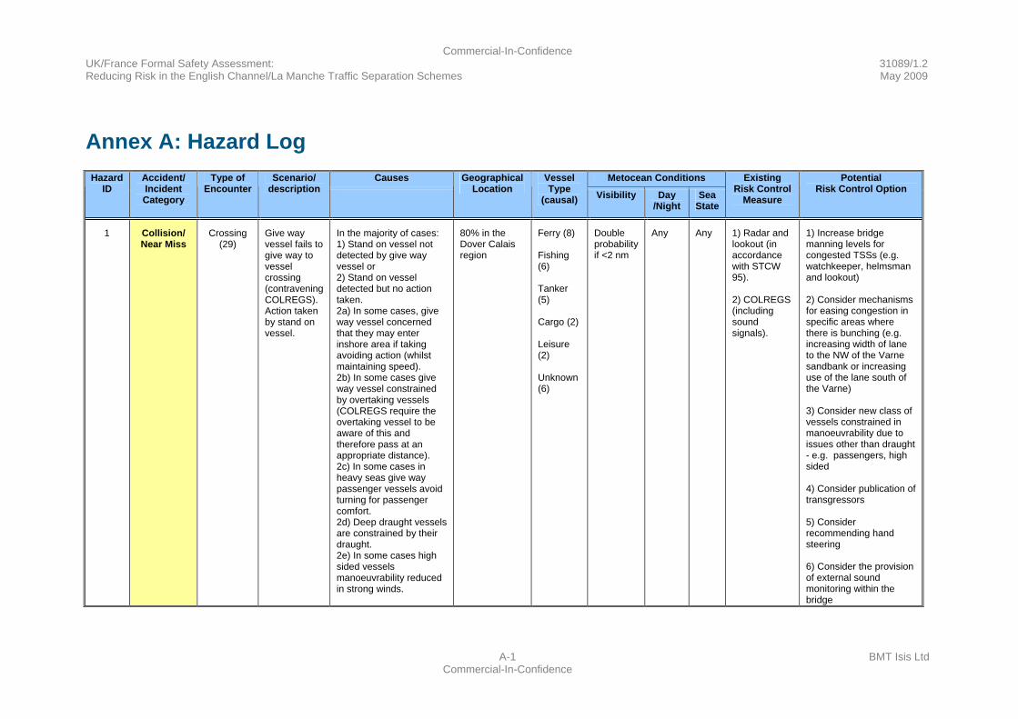
Annex A: Hazard Log
Causes Metocean Conditions Hazard ID
Accident/ Incident Category
Type of Encounter
Scenario/ description
Geographical Location
Vessel Type
(causal) Visibility Day /Night
Sea State
Existing Risk Control
Measure
Potential Risk Control Option
1 Collision/ Near Miss
Crossing (29)
Give way vessel fails to give way to vessel crossing (contravening COLREGS). Action taken by stand on vessel.
In the majority of cases: 1) Stand on vessel not detected by give way vessel or 2) Stand on vessel detected but no action taken. 2a) In some cases, give way vessel concerned that they may enter inshore area if taking avoiding action (whilst maintaining speed). 2b) In some cases give way vessel constrained by overtaking vessels (COLREGS require the overtaking vessel to be aware of this and therefore pass at an appropriate distance). 2c) In some cases in heavy seas give way passenger vessels avoid turning for passenger comfort. 2d) Deep draught vessels are constrained by their draught. 2e) In some cases high sided vessels manoeuvrability reduced in strong winds.
80% in the Dover Calais region
Ferry (8) Fishing (6) Tanker (5) Cargo (2) Leisure (2) Unknown (6)
Double probability if <2 nm
Any Any 1) Radar and lookout (in accordance with STCW 95). 2) COLREGS (including sound signals).
1) Increase bridge manning levels for congested TSSs (e.g. watchkeeper, helmsman and lookout) 2) Consider mechanisms for easing congestion in specific areas where there is bunching (e.g. increasing width of lane to the NW of the Varne sandbank or increasing use of the lane south of the Varne) 3) Consider new class of vessels constrained in manoeuvrability due to issues other than draught - e.g. passengers, high sided 4) Consider publication of transgressors 5) Consider recommending hand steering 6) Consider the provision of external sound monitoring within the bridge
Commercial-In-Confidence UK/France Formal Safety Assessment: 31089/1.2 Reducing Risk in the English Channel/La Manche Traffic Separation Schemes May 2009
A-2 BMT Isis Ltd Commercial-In-Confidence
Hazard
ID Accident/ Incident Category
Type of Encounter
Scenario/ description
Causes Geographical Location
Vessel Type
(causal)
Metocean Conditions
Existing Risk
Control Measure
PotentialRisk
Control Option
Hazard ID Accident/ Incident Category
2 Collision/ Near Miss
Overtaking (16)
Overtaking vessel passes too close or collides
In the majority of cases: 1) Vessel not detected by overtaking vessel or 2) Acceptance of a small CPA by some. Lateral bunching has also been observed in areas where there is unused space
Particularly in the area of the Varne, where vessels hug the UK side (perhaps shortest or easiest route or to maintain UK mobile phone coverage)
Tanker (5) Cargo (4) Container (4) Unknown (3)
Double probability if <2 nm
Any Any 1) Radar and lookout (In accordance with STCW 95) 2) COLREGS
1) increase bridge manning levels for congested TSSs (e.g. watchkeeper, helmsman and lookout). 2) Consider mechanisms for easing congestion in specific areas where there is bunching (e.g. increasing width of lane to the NW of the Varne sandbank or increasing use of SW of Varne) 3) Consider introducing a recommended passing distance 4) Consider recommending mobile phone repeater
Commercial-In-Confidence UK/France Formal Safety Assessment: 31089/1.2 Reducing Risk in the English Channel/La Manche Traffic Separation Schemes May 2009
A-3 BMT Isis Ltd Commercial-In-Confidence
Hazard
ID Accident/ Incident Category
Type of Encounter
Scenario/ description
Causes Geographical Location
Vessel Type
(causal)
Metocean Conditions
Existing Risk
Control Measure
PotentialRisk
Control Option
Hazard ID Accident/ Incident Category
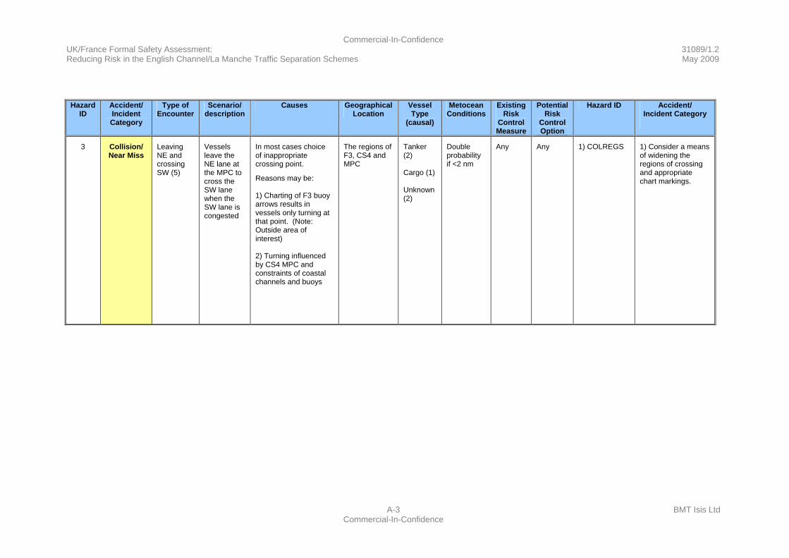
3 Collision/ Near Miss
Leaving NE and crossing SW (5)
Vessels leave the NE lane at the MPC to cross the SW lane when the SW lane is congested
In most cases choice of inappropriate crossing point.
Reasons may be: 1) Charting of F3 buoy arrows results in vessels only turning at that point. (Note: Outside area of interest) 2) Turning influenced by CS4 MPC and constraints of coastal channels and buoys
The regions of F3, CS4 and MPC
Tanker (2) Cargo (1) Unknown (2)
Double probability if <2 nm
Any Any 1) COLREGS 1) Consider a means of widening the regions of crossing and appropriate chart markings.
Commercial-In-Confidence UK/France Formal Safety Assessment: 31089/1.2 Reducing Risk in the English Channel/La Manche Traffic Separation Schemes May 2009
A-4 BMT Isis Ltd Commercial-In-Confidence
Hazard
ID Accident/ Incident Category
Type of Encounter
Scenario/ description
Causes Geographical Location
Vessel Type
(causal)
Metocean Conditions
Existing Risk
Control Measure
PotentialRisk
Control Option
Hazard ID Accident/ Incident Category
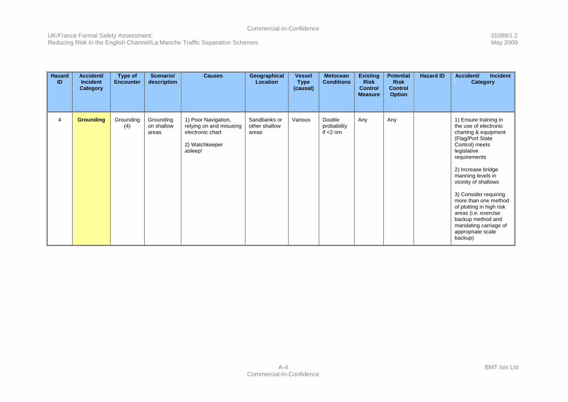
4 Grounding Grounding (4)
Grounding on shallow areas
1) Poor Navigation, relying on and misusing electronic chart 2) Watchkeeper asleep!
Sandbanks or other shallow areas
Various Double probability if <2 nm
Any Any 1) Ensure training in the use of electronic charting & equipment (Flag/Port State Control) meets legislative requirements 2) Increase bridge manning levels in vicinity of shallows 3) Consider requiring more than one method of plotting in high risk areas (i.e. exercise backup method and mandating carriage of appropriate scale backup)

Commercial-In-Confidence UK/France Formal Safety Assessment: 31089/1.2 Reducing Risk in the English Channel/La Manche Traffic Separation Schemes May 2009
A-5 BMT Isis Ltd Commercial-In-Confidence
Hazard
ID Accident/ Incident Category
Type of Encounter
Scenario/ description
Causes Geographical Location
Vessel Type
(causal)
Metocean Conditions
Existing Risk
Control Measure
PotentialRisk
Control Option
Hazard ID Accident/ Incident Category
5 Collision/ Near Miss
Approach and Passing (4)
Approach and passing generally a fishing vessel
1) Fishing vessel not detected 2) Fishing vessel movement unpredictable
Fishing grounds
Fishing (4)
Double probability if <2 nm
Any Any 1) Radar and lookout (In accordance with STCW 95) 2) COLREGS Rule 10(i)
1) Introduction of AIS to fishing vessels >15m and the use of that information by other vessels (could be enhanced to indicate if fishing) 2) TSS dedicated website. Includes name and shame 3) Consider introducing a requirement for fishing vessels to report to VTS
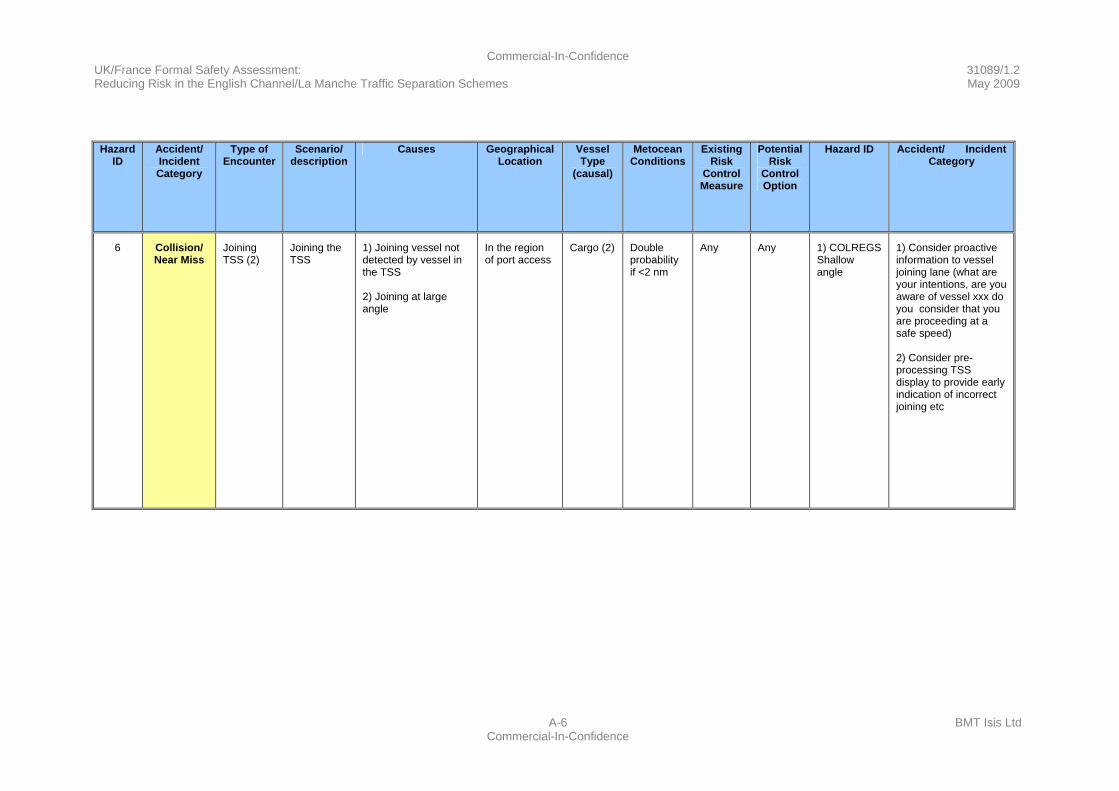
Commercial-In-Confidence UK/France Formal Safety Assessment: 31089/1.2 Reducing Risk in the English Channel/La Manche Traffic Separation Schemes May 2009
A-6 BMT Isis Ltd Commercial-In-Confidence
Hazard
ID Accident/ Incident Category
Type of Encounter
Scenario/ description
Causes Geographical Location
Vessel Type
(causal)
Metocean Conditions
Existing Risk
Control Measure
PotentialRisk
Control Option
Hazard ID Accident/ Incident Category
6 Collision/ Near Miss
Joining TSS (2)
Joining the TSS
1) Joining vessel not detected by vessel in the TSS 2) Joining at large angle
In the region of port access
Cargo (2) Double probability if <2 nm
Any Any 1) COLREGS Shallow angle
1) Consider proactive information to vessel joining lane (what are your intentions, are you aware of vessel xxx do you consider that you are proceeding at a safe speed) 2) Consider pre-processing TSS display to provide early indication of incorrect joining etc
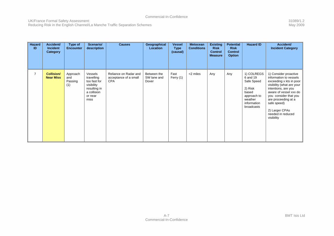
Commercial-In-Confidence UK/France Formal Safety Assessment: 31089/1.2 Reducing Risk in the English Channel/La Manche Traffic Separation Schemes May 2009
A-7 BMT Isis Ltd Commercial-In-Confidence
Hazard
ID Accident/ Incident Category
Type of Encounter
Scenario/ description
Causes Geographical Location
Vessel Type
(causal)
Metocean Conditions
Existing Risk
Control Measure
PotentialRisk
Control Option
Hazard ID Accident/ Incident Category
7 Collision/ Near Miss
Approach and Passing (1)
Vessels travelling too fast for visibility resulting in a collision or near miss
Reliance on Radar and acceptance of a small CPA
Between the SW lane and Dover
Fast Ferry (1)
<2 miles Any Any 1) COLREGS 6 and 19 Safe Speed 2) Risk based approach to weather information broadcasts
1) Consider proactive information to vessels exceeding x kts in poor visibility (what are your intentions, are you aware of vessel xxx do you consider that you are proceeding at a safe speed) 2) Larger CPAs needed in reduced visibility
Commercial-In-Confidence UK/France Formal Safety Assessment: 31089/1.2 Reducing Risk in the English Channel/La Manche Traffic Separation Schemes May 2009
B-1 BMT Isis Ltd Commercial-In-Confidence
Annex B: Cost Benefit Assessment
B.1 Summary
B.1.1 The costs of an accident have been investigated, in sufficient detail for a broad order of costs benefits analysis, and these together with the costs and the benefits of RCOs have been combined within a cost benefit assessment spreadsheet. From this, the most cost beneficial options have been presented with a commentary on the options in general.
B.2 Introduction
B.2.1 A number of credible incident/accident scenarios are developed for collision events. These are used as a basis for the Cost Benefit Assessment and are developed to a level that is fit for purpose for this need. The analysis is focussed purely on developing credible and likely accidents/incidents that could happen within the English Channel/La Manche TSS.
B.2.2 This annex develops credible scenarios both worst case and likely, and assigns costs. The costs associated with recovery of a wreck and removal of pollutants from a wreck are not considered in this analysis as this is a worst case scenario that falls outside our consideration of credible events. An event such as the break-up of a containership such as the MSC NAPOLI, or a tanker such as the PRESTIGE or the sinking of a laden chemical tanker such as the IEVOLI SUN are not considered as credible worst case events for this analysis. These events were not the result of a collision/grounding and are therefore outside the scope of this study. Whilst the events happened in the English Channel/La Manche they were the result of substandard operation/ships in combination with bad weather. In our analysis we have also ignored the costs of recovery of beached ships. It has been assumed that any ship incapacitated due to a collision/grounding does not result in a beaching as the incapacitated ship(s) can either anchor or accept a tow from a dedicated Emergency Towing Vessel (ETV) or another tug.
B.2.3 Note that no attempt has been made to apportion the costs of the incidents/accidents for the purposes of this cost benefit analysis; all that needs to be taken into account is a cost for the incidents/accidents.

Commercial-In-Confidence UK/France Formal Safety Assessment: 31089/1.2 Reducing Risk in the English Channel/La Manche Traffic Separation Schemes May 2009
B-2 BMT Isis Ltd Commercial-In-Confidence
B.3 Groundings
B.3.1 The outcome of an accident/incident involving a grounding will be dependent upon the prevailing bottom type, which within the TSS and its immediate environs is sand/shingle. As a consequence it can be expected that major structural damage occurring to vessels that run aground is unlikely to occur. Therefore the outcome of a grounding is considered not be an event that results in pollution, this is particularly true for a modern double-hulled tanker. Also it might be expected that there will be minimal risk of injury to the crew on running aground on this type of bottom. The recent grounding of the LT CORTESIA, a 6,200 TEU containership on the Varne which suffered only minor structural damage and no injuries to the crew is a good example of the low level of damage and injury that might be expected to occur to a vessel that grounds even at an operational speed (see Reference 1 at B.15).
B.4 Collisions
The Cost of an Accident
B.4.1 A monetary value can be put upon the cost that society might be expected to pay to prevent a fatality or to prevent a spill of persistent oil. This section reviews the costs that society might pay to prevent these disasters and provides fit for purpose figures that can be used in a cost benefit analysis.
B.4.2 This analysis of accident costs starts by identifying recent maritime incidents and accidents that can be used to assess the likely consequences and probability of a grounding or a collision happening within the TSS. A number of incidents have been reviewed and arranged under the headings of:
a. Ferry: Loss of life.
b. Cruise Ship: Loss of life.
c. Cargo Vessel: Loss of Life.
d. Fishing Vessel: Loss of Life.
e. Collisions: Spills.
f. Collisions: Sinkings.
g. Worst Case Scenarios:
(i) Ferries.
(ii) Tankers.
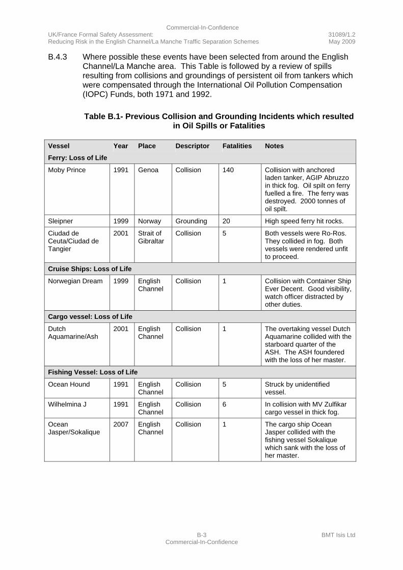
Commercial-In-Confidence UK/France Formal Safety Assessment: 31089/1.2 Reducing Risk in the English Channel/La Manche Traffic Separation Schemes May 2009
B-3 BMT Isis Ltd Commercial-In-Confidence
B.4.3 Where possible these events have been selected from around the English Channel/La Manche area. This Table is followed by a review of spills resulting from collisions and groundings of persistent oil from tankers which were compensated through the International Oil Pollution Compensation (IOPC) Funds, both 1971 and 1992.
Table B.1- Previous Collision and Grounding Incidents which resulted
in Oil Spills or Fatalities Vessel Year Place Descriptor Fatalities Notes
Ferry: Loss of Life
Moby Prince 1991 Genoa Collision 140 Collision with anchored laden tanker, AGIP Abruzzo in thick fog. Oil spilt on ferry fuelled a fire. The ferry was destroyed. 2000 tonnes of oil spilt.
Sleipner 1999 Norway Grounding 20 High speed ferry hit rocks.
Ciudad de Ceuta/Ciudad de Tangier
2001 Strait of Gibraltar
Collision 5 Both vessels were Ro-Ros. They collided in fog. Both vessels were rendered unfit to proceed.
Cruise Ships: Loss of Life
Norwegian Dream 1999 English Channel
Collision 1 Collision with Container Ship Ever Decent. Good visibility, watch officer distracted by other duties.
Cargo vessel: Loss of Life
Dutch Aquamarine/Ash
2001 English Channel
Collision 1 The overtaking vessel Dutch Aquamarine collided with the starboard quarter of the ASH. The ASH foundered with the loss of her master.
Fishing Vessel: Loss of Life
Ocean Hound 1991 English Channel
Collision 5 Struck by unidentified vessel.
Wilhelmina J 1991 English Channel
Collision 6 In collision with MV Zulfikar cargo vessel in thick fog.
Ocean Jasper/Sokalique
2007 English Channel
Collision 1 The cargo ship Ocean Jasper collided with the fishing vessel Sokalique which sank with the loss of her master.
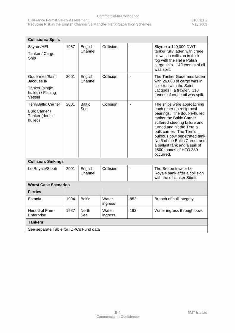
Commercial-In-Confidence UK/France Formal Safety Assessment: 31089/1.2 Reducing Risk in the English Channel/La Manche Traffic Separation Schemes May 2009
B-4 BMT Isis Ltd Commercial-In-Confidence
Collisions: Spills
Skyron/HEL
Tanker / Cargo Ship
1987 English Channel
Collision - Skyron a 140,000 DWT tanker fully laden with crude oil was in collision in thick fog with the Hel a Polish cargo ship. 140 tonnes of oil was spilt.
Gudermes/Saint Jacques II/
Tanker (single hulled) / Fishing Vessel
2001 English Channel
Collision - The Tanker Gudermes laden with 26,000 of cargo was in collision with the Saint Jacques II a trawler. 110 tonnes of crude oil was spilt.
Tern/Baltic Carrier
Bulk Carrier / Tanker (double hulled)
2001 Baltic Sea
Collision - The ships were approaching each other on reciprocal bearings. The double-hulled tanker the Baltic Carrier suffered steering failure and turned and hit the Tern a bulk carrier. The Tern’s bulbous bow penetrated tank No 6 of the Baltic Carrier and a ballast tank and a spill of 2500 tonnes of HFO 380 occurred.
Collision: Sinkings
Le Royale/Siboti 2001 English Channel
Collision - The Breton trawler Le Royale sank after a collision with the oil tanker Siboti.
Worst Case Scenarios
Ferries
Estonia 1994 Baltic Water ingress
852 Breach of hull integrity.
Herald of Free Enterprise
1987 North Sea
Water ingress
193 Water ingress through bow.
Tankers
See separate Table for IOPCs Fund data
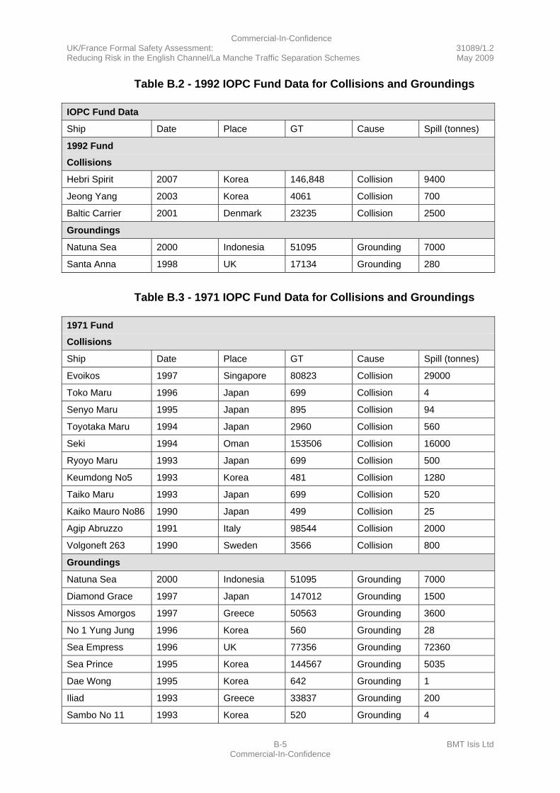
Commercial-In-Confidence UK/France Formal Safety Assessment: 31089/1.2 Reducing Risk in the English Channel/La Manche Traffic Separation Schemes May 2009
B-5 BMT Isis Ltd Commercial-In-Confidence
Table B.2 - 1992 IOPC Fund Data for Collisions and Groundings IOPC Fund Data
Ship Date Place GT Cause Spill (tonnes)
1992 Fund
Collisions
Hebri Spirit 2007 Korea 146,848 Collision 9400
Jeong Yang 2003 Korea 4061 Collision 700
Baltic Carrier 2001 Denmark 23235 Collision 2500
Groundings
Natuna Sea 2000 Indonesia 51095 Grounding 7000
Santa Anna 1998 UK 17134 Grounding 280
Table B.3 - 1971 IOPC Fund Data for Collisions and Groundings
1971 Fund
Collisions
Ship Date Place GT Cause Spill (tonnes)
Evoikos 1997 Singapore 80823 Collision 29000
Toko Maru 1996 Japan 699 Collision 4
Senyo Maru 1995 Japan 895 Collision 94
Toyotaka Maru 1994 Japan 2960 Collision 560
Seki 1994 Oman 153506 Collision 16000
Ryoyo Maru 1993 Japan 699 Collision 500
Keumdong No5 1993 Korea 481 Collision 1280
Taiko Maru 1993 Japan 699 Collision 520
Kaiko Mauro No86 1990 Japan 499 Collision 25
Agip Abruzzo 1991 Italy 98544 Collision 2000
Volgoneft 263 1990 Sweden 3566 Collision 800
Groundings
Natuna Sea 2000 Indonesia 51095 Grounding 7000
Diamond Grace 1997 Japan 147012 Grounding 1500
Nissos Amorgos 1997 Greece 50563 Grounding 3600
No 1 Yung Jung 1996 Korea 560 Grounding 28
Sea Empress 1996 UK 77356 Grounding 72360
Sea Prince 1995 Korea 144567 Grounding 5035
Dae Wong 1995 Korea 642 Grounding 1
Iliad 1993 Greece 33837 Grounding 200
Sambo No 11 1993 Korea 520 Grounding 4
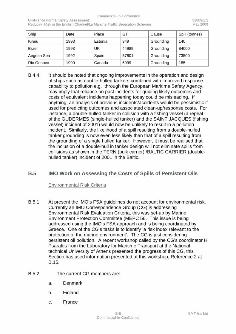
Commercial-In-Confidence UK/France Formal Safety Assessment: 31089/1.2 Reducing Risk in the English Channel/La Manche Traffic Separation Schemes May 2009
B-6 BMT Isis Ltd Commercial-In-Confidence
Ship Date Place GT Cause Spill (tonnes)
Kihnu 1993 Estonia 949 Grounding 140
Braer 1993 UK 44989 Grounding 84000
Aegean Sea 1992 Spain 57801 Grounding 73500
Rio Orinoco 1990 Canada 5999 Grounding 185
B.4.4 It should be noted that ongoing improvements in the operation and design of ships such as double-hulled tankers combined with improved response capability to pollution e.g. through the European Maritime Safety Agency, may imply that reliance on past incidents for guiding likely outcomes and costs of equivalent incidents happening today could be misleading. If anything, an analysis of previous incidents/accidents would be pessimistic if used for predicting outcomes and associated clean-up/response costs. For instance, a double-hulled tanker in collision with a fishing vessel (a repeat of the GUDERMES (single-hulled tanker) and the SAINT JACQUES (fishing vessel) incident of 2001) would now be unlikely to result in a pollution incident. Similarly, the likelihood of a spill resulting from a double-hulled tanker grounding is now even less likely than that of a spill resulting from the grounding of a single hulled tanker. However, it must be realised that the inclusion of a double-hull in tanker design will not eliminate spills from collisions as shown in the TERN (bulk carrier) /BALTIC CARRIER (double-hulled tanker) incident of 2001 in the Baltic.
B.5 IMO Work on Assessing the Costs of Spills of Persistent Oils
Environmental Risk Criteria
B.5.1 At present the IMO’s FSA guidelines do not account for environmental risk.
Currently an IMO Correspondence Group (CG) is addressing Environmental Risk Evaluation Criteria, this was set-up by Marine Environment Protection Committee (MEPC 56. This issue is being addressed using the IMO’s FSA approach and is being coordinated by Greece. One of the CG’s tasks is to identify ‘a risk index relevant to the protection of the marine environment’. The CG is just considering persistent oil pollution. A recent workshop called by the CG’s coordinator H Psaraftis from the Laboratory for Maritime Transport at the National technical University of Athens presented the progress of this CG, this Section has used information presented at this workshop, Reference 2 at B.15.
B.5.2 The current CG members are:
a. Denmark
b. Finland
c. France
Commercial-In-Confidence UK/France Formal Safety Assessment: 31089/1.2 Reducing Risk in the English Channel/La Manche Traffic Separation Schemes May 2009
B-7 BMT Isis Ltd Commercial-In-Confidence
d. Germany
e. Greece
f. Japan
g. Malaysia
h. Netherlands
i. New Zealand
j. Norway
k. Spain
l. Turkey
m. UK
n. USA
o. BIMCO
p. IACS
q. Intertanko
r. OCIMF
B.5.3 IMO Submission MEPC 58/23 (16th October 2008) reported the progress of the CG. This document significantly notes that ‘The group had also agreed that, in spite of various documented shortcomings, in steps 3 and 4 of the FSA one could use an “oil spill cost per unit volume” criterion to assess the cost effectiveness of RCOs. In fact, in spite of the extensive discussion and debate on this subject since MEPC 56, the group had agreed that no better and practical alternative was identified’.
B.5.4 On the issue of the proper Risk Matrix or Severity Index (FSA Step 1) ‘the group had proposed to use oil spill volume as the severity variable’. The CG has noted that a severity index for environmental criteria is straightforward if a volume-based approach to a spill is adopted.
B.5.5 There was a divergence of opinion within the CG on what a threshold for an ‘oil spill cost per unit volume’ might be. The group discussed the concept of the Cost of Averting a Tonne of oil Spilt (CATS). The CATS figure included the basic clean-up costs and factors addressing environmental costs and society’s willingness to pay to prevent spills instead of incurring their costs – an assurance factor.
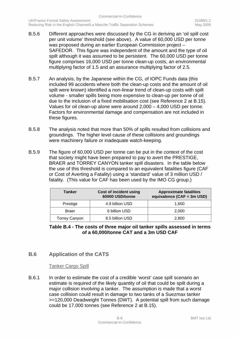
Commercial-In-Confidence UK/France Formal Safety Assessment: 31089/1.2 Reducing Risk in the English Channel/La Manche Traffic Separation Schemes May 2009
B-8 BMT Isis Ltd Commercial-In-Confidence
B.5.6 Different approaches were discussed by the CG in deriving an ‘oil spill cost per unit volume’ threshold (see above). A value of 60,000 USD per tonne was proposed during an earlier European Commission project – SAFEDOR. This figure was independent of the amount and the type of oil spilt although it was assumed to be persistent. The 60,000 USD per tonne figure comprises 16,000 USD per tonne clean-up costs, an environmental multiplying factor of 1.5 and an assurance multiplying factor of 2.5.
B.5.7 An analysis, by the Japanese within the CG, of IOPC Funds data (this included 99 accidents where both the clean-up costs and the amount of oil spilt were known) identified a non-linear trend of clean-up costs with spilt volume - smaller spills being more expensive to clean-up per tonne of oil due to the inclusion of a fixed mobilisation cost (see Reference 2 at B.15). Values for oil clean-up alone were around 2,000 – 4,000 USD per tonne. Factors for environmental damage and compensation are not included in these figures.
B.5.8 The analysis noted that more than 50% of spills resulted from collisions and groundings. The higher level cause of these collisions and groundings were machinery failure or inadequate watch-keeping.
B.5.9 The figure of 60,000 USD per tonne can be put in the context of the cost that society might have been prepared to pay to avert the PRESTIGE, BRAER and TORREY CANYON tanker spill disasters. In the table below the use of this threshold is compared to an equivalent fatalities figure (CAF or Cost of Averting a Fatality) using a ‘standard’ value of 3 million USD / fatality. (This value for CAF has been used by the IMO CG group.)
Tanker Cost of incident using
60000 USD/tonne Approximate fatalities
equivalence (CAF = 3m USD)
Prestige 4.9 billion USD 1,600
Braer 6 billion USD 2,000
Torrey Canyon 8.5 billion USD 2,800
Table B.4 - The costs of three major oil tanker spills assessed in terms of a 60,000/tonne CAT and a 3m USD CAF
B.6 Application of the CATS
Tanker Cargo Spill
B.6.1 In order to estimate the cost of a credible ‘worst’ case spill scenario an estimate is required of the likely quantity of oil that could be spilt during a major collision involving a tanker. The assumption is made that a worst case collision could result in damage to two tanks of a Suezmax tanker >=120,000 Deadweight Tonnes (DWT). A potential spill from such damage could be 17,000 tonnes (see Reference 2 at B.15).

Commercial-In-Confidence UK/France Formal Safety Assessment: 31089/1.2 Reducing Risk in the English Channel/La Manche Traffic Separation Schemes May 2009
B-9 BMT Isis Ltd Commercial-In-Confidence
Smaller Tanker Spill/Bunker Tank Spill
B.6.2 The maximum size of a bunker tank now allowed under the Bunker’s Convention is 2500 tonnes. The largest spill of bunker fuel is therefore of this magnitude. A spill from a large vessel’s bunker tank will be of Heavy Fuel Oil (HFO) and will therefore be persistent. This spill quantity, 2500 tonnes, could also be realistic quantity for a spill where a serious collision happens with a smaller tanker.
Small Spill
B.6.3 Where a collision is less severe than the two examples cited above and involves smaller vessels the result is likely to be a smaller level of damage and a much smaller spill could be expected. The assumption is made that this might result in a spill of around a 100 tonnes. Two examples of spills of this volume were the SKYRON/HEL in 1987 and the GUDERMES/SAINT JACQUES in 2001.
The Cost of a Collision
B.6.4 Using the generous value for the CATS parameter of 60,000 USD/tonne and spill volumes of 17,000 tonnes from a large tanker incident and 2,500 tonnes from a bunker/smaller tanker collision the cost that society might be prepared to pay to avoid such credible ‘worst case’ incidents are:
Tanker incident (major collision): 17,000 tonnes = 1020 mUSD Bunker incident/small tanker (major collision): 2,500 tonnes = 150 mUSD.
B.6.5 The cost for the more likely smaller spill of 100 tonnes is:
Smaller tanker or smaller bunker (minor collision): 100 tonnes = 60 mUSD.
B.6.6 It is however unlikely that all the oil contained in a tank will be spilt from a ruptured tank(s), a more credible figure could be 50% of the tank’s capacity. The IMO CG also currently considers the 60,000 USD figure too high and expects that the final value will be less than this. From a review of the analysis conducted by the Japanese it would seem that a more likely final figure for the CATS value for a spill of up to 10,000 tonnes could be 15,000 USD / tonne.
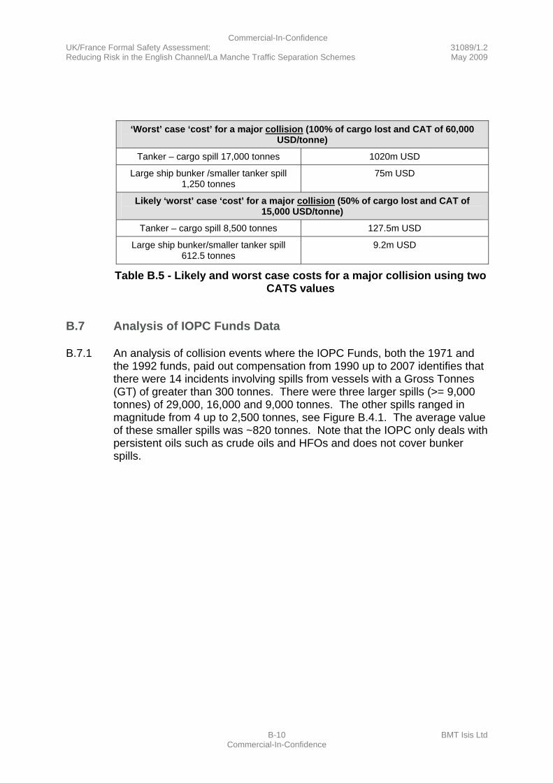
Commercial-In-Confidence UK/France Formal Safety Assessment: 31089/1.2 Reducing Risk in the English Channel/La Manche Traffic Separation Schemes May 2009
B-10 BMT Isis Ltd Commercial-In-Confidence
‘Worst’ case ‘cost’ for a major collision (100% of cargo lost and CAT of 60,000
USD/tonne)
Tanker – cargo spill 17,000 tonnes 1020m USD
Large ship bunker /smaller tanker spill 1,250 tonnes
75m USD
Likely ‘worst’ case ‘cost’ for a major collision (50% of cargo lost and CAT of 15,000 USD/tonne)
Tanker – cargo spill 8,500 tonnes 127.5m USD
Large ship bunker/smaller tanker spill 612.5 tonnes
9.2m USD
Table B.5 - Likely and worst case costs for a major collision using two CATS values
B.7 Analysis of IOPC Funds Data
B.7.1 An analysis of collision events where the IOPC Funds, both the 1971 and the 1992 funds, paid out compensation from 1990 up to 2007 identifies that there were 14 incidents involving spills from vessels with a Gross Tonnes (GT) of greater than 300 tonnes. There were three larger spills (>= 9,000 tonnes) of 29,000, 16,000 and 9,000 tonnes. The other spills ranged in magnitude from 4 up to 2,500 tonnes, see Figure B.4.1. The average value of these smaller spills was ~820 tonnes. Note that the IOPC only deals with persistent oils such as crude oils and HFOs and does not cover bunker spills.
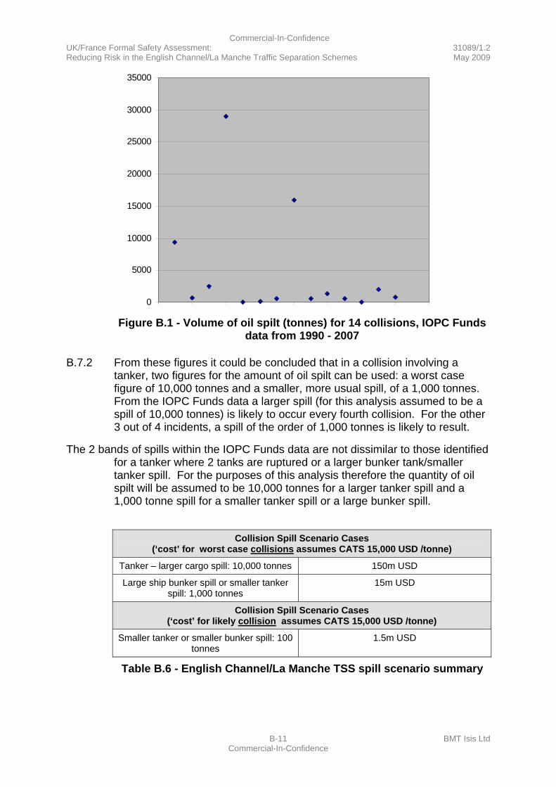
Commercial-In-Confidence UK/France Formal Safety Assessment: 31089/1.2 Reducing Risk in the English Channel/La Manche Traffic Separation Schemes May 2009
B-11 BMT Isis Ltd Commercial-In-Confidence
0
5000
10000
15000
20000
25000
30000
35000
Figure B.1 - Volume of oil spilt (tonnes) for 14 collisions, IOPC Funds
data from 1990 - 2007
B.7.2 From these figures it could be concluded that in a collision involving a tanker, two figures for the amount of oil spilt can be used: a worst case figure of 10,000 tonnes and a smaller, more usual spill, of a 1,000 tonnes. From the IOPC Funds data a larger spill (for this analysis assumed to be a spill of 10,000 tonnes) is likely to occur every fourth collision. For the other 3 out of 4 incidents, a spill of the order of 1,000 tonnes is likely to result.
The 2 bands of spills within the IOPC Funds data are not dissimilar to those identified for a tanker where 2 tanks are ruptured or a larger bunker tank/smaller tanker spill. For the purposes of this analysis therefore the quantity of oil spilt will be assumed to be 10,000 tonnes for a larger tanker spill and a 1,000 tonne spill for a smaller tanker spill or a large bunker spill.
Collision Spill Scenario Cases
(‘cost’ for worst case collisions assumes CATS 15,000 USD /tonne)
Tanker – larger cargo spill: 10,000 tonnes 150m USD
Large ship bunker spill or smaller tanker spill: 1,000 tonnes
15m USD
Collision Spill Scenario Cases (‘cost’ for likely collision assumes CATS 15,000 USD /tonne)
Smaller tanker or smaller bunker spill: 100 tonnes
1.5m USD
Table B.6 - English Channel/La Manche TSS spill scenario summary

Commercial-In-Confidence UK/France Formal Safety Assessment: 31089/1.2 Reducing Risk in the English Channel/La Manche Traffic Separation Schemes May 2009
B-12 BMT Isis Ltd Commercial-In-Confidence
B.8 Analysis of UK Continental Shelf Oil Spill Data
B.8.1 Note an analysis of the UK Continental Shelf oil spill statistics reported by the Maritime and Coastguard Agency from and including 2002 up to 2007 identified only four incidents where spills of greater than 1 tonne occurred. Spills of 1.8, 2 and 180 tonnes of non-persistent oils were spilt - diesel and gas oil. Only one spill of persistent oil occurred and this was from the MT WILLY which dragged its anchor. There were no spills over 1 tonne resulting from a collision. These statistics demonstrate that larger spills from collisions are infrequent.
Spills resulting from groundings from MCA ACOPS reports (UKCS 2002 – 2007 all
available data) for spills greater than 1 tonne
ETV Anglian Sovereign
2005 Scotland, Isle of Oxan
Vessel ran aground. Spill: 180 tonnes gasoil
MFV Sovereign 2005 Eastern Scotland
Vessel ran aground. Spill: 1.8 tonnes diesel
MV Jambo 2003 Western Scotland
Coaster ran aground and sank. Spill: 2 tonnes gasoil
MT Willy 2002 South West England
Vessel driven ashore and later refloated. Spill: 18 tonnes Fuel Oil
Table B.7 - Spills of greater than 1 tonne resulting from grounding in the UK’s Continental Shelf
B.9 Loss of ‘Other’ Cargoes
B.9.1 During a collision other cargoes may be lost such as deck cargoes and containers. Where a container is lost that contains a hazardous cargo/marine pollutant there will be recovery costs incurred. Other inert and hazardous deck cargos such as timber/drums etc can be lost as shown by the recent incidents of timber loss from the MV SINEGORSK (2009) & MV ICE PRINCE (2008) (note these were not due to collisions/groundings). Costs incurred here are those associated with clean-up/recovery and as per an oil spill cost will be very variable dependent on where the cargo beaches and the types and quantities of cargo lost.
B.9.2 It is hard to identify the value of any multiplying factor for environmental damage and the assurance factor that society might pay to avert this type of polluting incident. Indeed these incidents have proved to be learning events where response skills and contingency plans can be developed and preparations improved in anticipation of more significant events. Local authorities have also noticed a financial benefit with this type of incident, associated with spectators visiting the site and the extra income from clean-up contractors etc. staying in the area.
Commercial-In-Confidence UK/France Formal Safety Assessment: 31089/1.2 Reducing Risk in the English Channel/La Manche Traffic Separation Schemes May 2009
B-13 BMT Isis Ltd Commercial-In-Confidence
B.9.3 For a more major collision, it has been assumed that, a loss of deck cargo with a nominal clean-up cost of a 0.75m USD might be realistic.
B.10 Loss of Life
B.10.1 As per the spill scenario it is assumed that a grounding within the TSS would not result in a loss of life. The assumption is that, due to the bottom type, a grounding would be comparatively ‘gentle’ and whilst minor injuries might result there would not be a loss of life. The report on the grounding of the LT CORTESIA noted that the officer in charge was unaware that the vessel had grounded. He assumed that there was a technical problem as full power was requested but the vessel was not moving.
B.10.2 Whereas spills of significance will only occur from larger ships and tankers, a loss of life can occur on any vessel. The table below reports fatalities from particular vessel types that occurred within the English Channel/La Manche since 1991.
Fatalities in the English Channel Since 1991
Vessel Type Fatalities No of incidents
Ferry 0 0
Cruise ship 1 1
Cargo 1 1
Fishing 12 3
Tanker 0 0
Table B.8 - Fatalities occurring in the English Channel since 1991
Fishing Vessels
B.10.3 When a fishing vessel is in collision with a larger vessel a likely outcome will be that the fishing vessel is lost with the potential for some loss of life. The loss of a crew of 6 might be a worst case outcome for such a collision.
Cruise Ships
B.10.4 A review of casualties which occurred during thirty cruise ship incidents from across the world between 1995 and 2002 covering fires, grounding, collisions, sinkings and terrorism identified a total of 8 deaths and 87 injuries. Only 1 death (no injuries) resulted from a collision (there were 2 collisions and 4 groundings reported) and this incident happened in the English Channel/La Manche.
Commercial-In-Confidence UK/France Formal Safety Assessment: 31089/1.2 Reducing Risk in the English Channel/La Manche Traffic Separation Schemes May 2009
B-14 BMT Isis Ltd Commercial-In-Confidence
Ferries
B.10.5 There have been some events that resulted in a serious loss of life during ferry incidents e.g. the SALEM EXPRESS sinking in the Red Sea in 1991 with the loss of 1400 lives and the loss of the ESTONIA in the Baltic in 1994 with the loss of over 852 lives. However, there can be no comparison drawn between the operation of these ferries and those operating within the Channel/La Manche TSS.
Cargo Vessels/Tankers
B.10.6 As the sinking of the ASH in 2001 following a collision in the English Channel/La Manche demonstrated, a cargo ship can sink with the loss of lives.
B.11 Loss of life Scenarios
B.11.1 A collision can result in a fire or a sinking and this would be a worst case scenario. The consequence of such an incident would be worst, in terms of the potential for loss of life, if the ship that caught fire or sank was a ferry or a cruise ship. For a Ro-Ro ferry a sinking might be the result of a collision where the watertight bow doors/bulkhead was badly damaged during adverse weather conditions. For the purpose of this cost benefit analysis this type of worst possible event is not considered and instead a number of credible worst case incidents developed.
B.11.2 A credible worst case scenario might be the collision between a cargo vessel and a ferry/cruise ship were the impact results in say 10 – 20 deaths on the ferry. A likely event is a collision between a cargo vessel and a fishing vessel resulting in the loss of the fishing vessel with the loss of say 4 lives. A possible event is the collision between 2 cargo/tanker vessels with the loss of say 1-2 lives (these scenarios assume that there are no further complications resulting from the collision such as a fire or explosion that leads to further deaths and possible sinkings/groundings).
B.11.3 The table below puts these scenarios in the context of the Cost of Averting a Fatality (CAF) cost. Note that for the lives lost during the ferry/cruise ship collision that a high value for the CAF figure of 6m USD / fatality has been used (see Reference 2 at B.15). This reflects the higher CAF costs that could be attributed to the loss of a paying passenger as opposed to the 3m USD CAF value that is more applicable to a member of a ship’s crew.
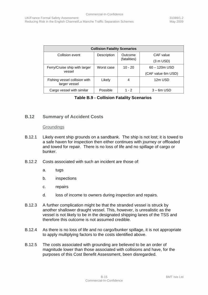
Commercial-In-Confidence UK/France Formal Safety Assessment: 31089/1.2 Reducing Risk in the English Channel/La Manche Traffic Separation Schemes May 2009
B-15 BMT Isis Ltd Commercial-In-Confidence
Collision Fatality Scenarios
Collision event Description Outcome (fatalities)
CAF value
(3 m USD)
Ferry/Cruise ship with larger vessel
Worst case 10 - 20 60 – 120m USD
(CAF value 6m USD)
Fishing vessel collision with larger vessel
Likely 4 12m USD
Cargo vessel with similar Possible 1 - 2 3 – 6m USD
Table B.9 - Collision Fatality Scenarios
B.12 Summary of Accident Costs
Groundings
B.12.1 Likely event ship grounds on a sandbank. The ship is not lost; it is towed to a safe haven for inspection then either continues with journey or offloaded and towed for repair. There is no loss of life and no spillage of cargo or bunker.
B.12.2 Costs associated with such an incident are those of:
a. tugs
b. inspections
c. repairs
d. loss of income to owners during inspection and repairs.
B.12.3 A further complication might be that the stranded vessel is struck by another shallower draught vessel. This, however, is unrealistic as the vessel is not likely to be in the designated shipping lanes of the TSS and therefore this outcome is not assumed credible.
B.12.4 As there is no loss of life and no cargo/bunker spillage, it is not appropriate to apply multiplying factors to the costs identified above.
B.12.5 The costs associated with grounding are believed to be an order of magnitude lower than those associated with collisions and have, for the purposes of this Cost Benefit Assessment, been disregarded.
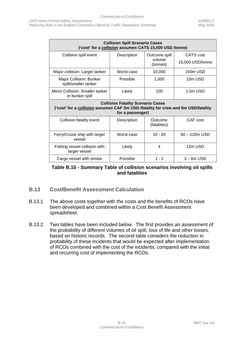
Commercial-In-Confidence UK/France Formal Safety Assessment: 31089/1.2 Reducing Risk in the English Channel/La Manche Traffic Separation Schemes May 2009
B-16 BMT Isis Ltd Commercial-In-Confidence
Collision Spill Scenario Cases
(‘cost’ for a collision assumes CATS 15,000 USD /tonne)
Collision spill event Description Outcome spill volume (tonnes)
CATS cost
15,000 USD/tonne
Major collision: Larger tanker Worst case 10,000 150m USD
Major Collision: Bunker spill/smaller tanker
Possible 1,000 15m USD
Minor Collision: Smaller tanker or bunker spill
Likely 100 1.5m USD
Collision Fatality Scenario Cases (‘cost’ for a collision assumes CAF 3m USD /fatality for crew and 6m USD/fatality
for a passenger)
Collision fatality event Description Outcome (fatalities)
CAF cost
Ferry/Cruise ship with larger vessel
Worst case 10 - 20 60 – 120m USD
Fishing vessel collision with larger vessel
Likely 4 12m USD
Cargo vessel with similar Possible 1 - 2 3 – 6m USD
Table B.10 - Summary Table of collision scenarios involving oil spills and fatalities
B.13 Cost/Benefit Assessment Calculation
B.13.1 The above costs together with the costs and the benefits of RCOs have been developed and combined within a Cost Benefit Assessment spreadsheet.
B.13.2 Two tables have been included below. The first provides an assessment of the probability of different volumes of oil spill, loss of life and other losses, based on historic records. The second table considers the reduction in probability of these incidents that would be expected after implementation of RCOs combined with the cost of the incidents, compared with the initial and recurring cost of implementing the RCOs.
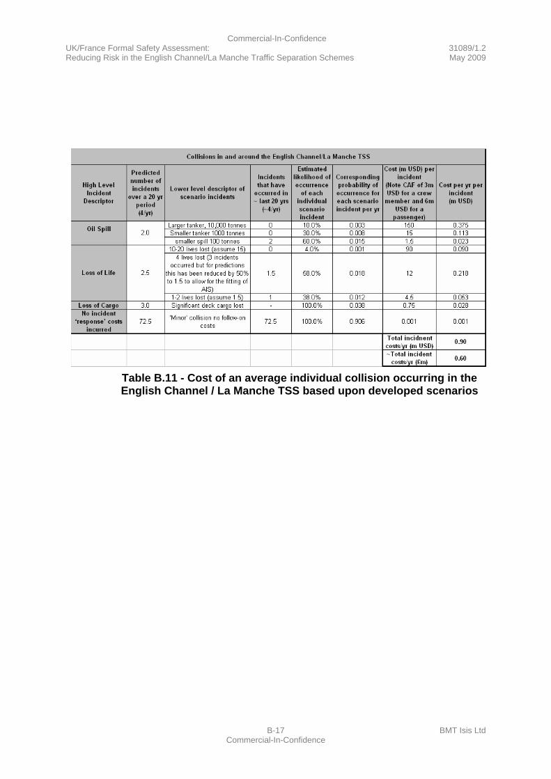
Commercial-In-Confidence UK/France Formal Safety Assessment: 31089/1.2 Reducing Risk in the English Channel/La Manche Traffic Separation Schemes May 2009
B-17 BMT Isis Ltd Commercial-In-Confidence
Table B.11 - Cost of an average individual collision occurring in the English Channel / La Manche TSS based upon developed scenarios

Commercial-In-Confidence UK/France Formal Safety Assessment: 31089/1.2 Reducing Risk in the English Channel/La Manche Traffic Separation Schemes May 2009
B-18 BMT Isis Ltd Commercial-In-Confidence
This page intentionally left blank.

Commercial-In-Confidence UK/France Formal Safety Assessment: 31089/1.2 Reducing Risk in the English Channel/La Manche Traffic Separation Schemes May 2009
B-19 BMT Isis Ltd Commercial-In-Confidence
Table B.12 - Table of Risk Control Options - Cost Benefit Assessment

Commercial-In-Confidence UK/France Formal Safety Assessment: 31089/1.2 Reducing Risk in the English Channel/La Manche Traffic Separation Schemes May 2009
B-20 BMT Isis Ltd Commercial-In-Confidence
This page intentionally left blank.
Commercial-In-Confidence UK/France Formal Safety Assessment: 31089/1.2 Reducing Risk in the English Channel/La Manche Traffic Separation Schemes May 2009
B-21 BMT Isis Ltd Commercial-In-Confidence
B.14 The Cost Beneficial Options
B.14.1 The RCOs are listed below according to the cost benefit ratio.
B.14.2 As can be seen, splitting the traffic around the Varne (for example by recommending vessels over 130 metres in length to pass south of the Varne) is the most cost beneficial option. The benefit of this RCO being approximately 50 times the cost.
B.14.3 Clarifying the extent of the crossing zone on the chart for when leaving the NE lane and crossing the SW lane is also cost beneficial. The benefit of this RCO being approximately 25 times the cost.
B.14.4 Developing and implementing alarms and alerting vessels to potential collisions or groundings is also cost beneficial. The benefit of this RCO being approximately 14 times the cost.
B.14.5 Amending COLREGs Rule 9 to make it clear that in a busy one way TSS that it is not necessary to keep to the starboard side of a narrow channel is also cost beneficial. The benefit of this RCO being approximately 4 to 5 times the cost.
B.14.6 Including visibility sensors on buoys is approximately cost neutral.
B.14.7 Dividing the TSS into four sections with dedicated VTS operators costs 2-3 times the benefit.
B.14.8 Requiring deep water pilots or additional bridge manning when passing through the TSS would cost 60 and 120 times the benefit, respectively. These are in the main cost benefit assessment table but not in the summary below.
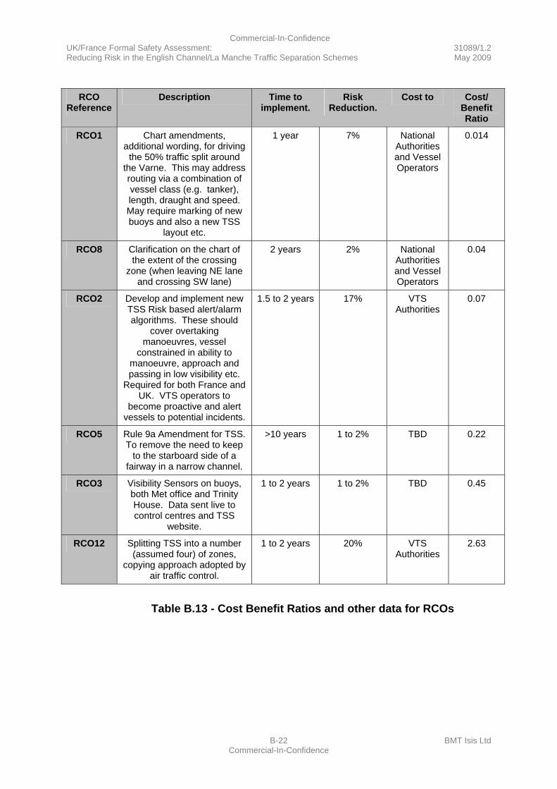
Commercial-In-Confidence UK/France Formal Safety Assessment: 31089/1.2 Reducing Risk in the English Channel/La Manche Traffic Separation Schemes May 2009
B-22 BMT Isis Ltd Commercial-In-Confidence
RCO
Reference Description Time to
implement. Risk
Reduction. Cost to Cost/
Benefit Ratio
RCO1 Chart amendments, additional wording, for driving
the 50% traffic split around the Varne. This may address routing via a combination of vessel class (e.g. tanker), length, draught and speed. May require marking of new buoys and also a new TSS
layout etc.
1 year 7% National Authorities and Vessel Operators
0.014
RCO8 Clarification on the chart of the extent of the crossing
zone (when leaving NE lane and crossing SW lane)
2 years 2% National Authorities and Vessel Operators
0.04
RCO2 Develop and implement new TSS Risk based alert/alarm algorithms. These should
cover overtaking manoeuvres, vessel
constrained in ability to manoeuvre, approach and passing in low visibility etc.
Required for both France and UK. VTS operators to
become proactive and alert vessels to potential incidents.
1.5 to 2 years 17% VTS Authorities
0.07
RCO5 Rule 9a Amendment for TSS. To remove the need to keep
to the starboard side of a fairway in a narrow channel.
>10 years 1 to 2% TBD 0.22
RCO3 Visibility Sensors on buoys, both Met office and Trinity House. Data sent live to control centres and TSS
website.
1 to 2 years 1 to 2% TBD 0.45
RCO12 Splitting TSS into a number (assumed four) of zones,
copying approach adopted by air traffic control.
1 to 2 years 20% VTS Authorities
2.63
Table B.13 - Cost Benefit Ratios and other data for RCOs
Commercial-In-Confidence UK/France Formal Safety Assessment: 31089/1.2 Reducing Risk in the English Channel/La Manche Traffic Separation Schemes May 2009
B-23 BMT Isis Ltd Commercial-In-Confidence
B.15 References
1. Grounding of the LT CORTESIA on 2 January 2008 on the Varne Bank in the English Channel. Investigation Report 01/08, Federal Bureau of Maritime Casualty Investigation Ministry of Transport Hamburg. April 2009.
2. Environmental Risk Evaluation Criteria Workshop held at the National technical University of Athens, Laboratory for Maritime Transport, 27 February 2009. See http://www.martrans.org/wsenv.htm.
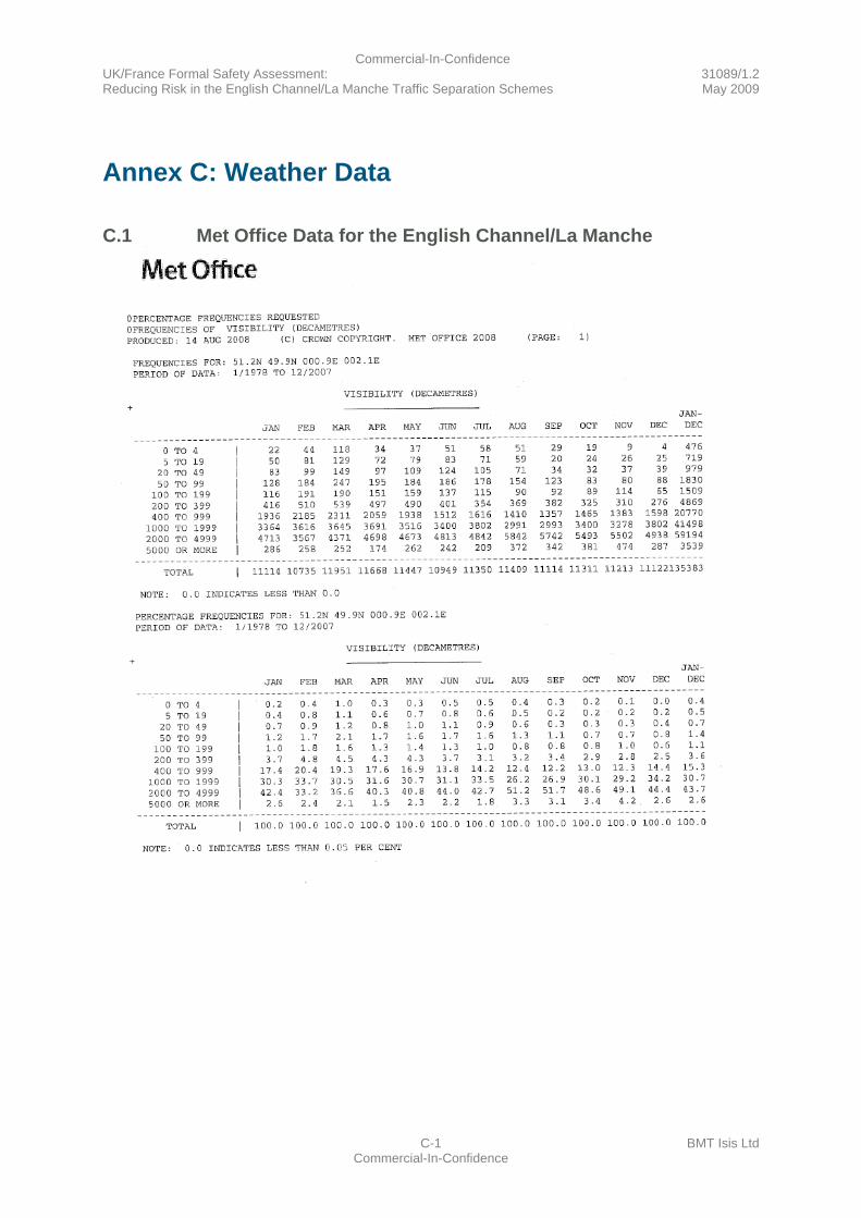
Commercial-In-Confidence UK/France Formal Safety Assessment: 31089/1.2 Reducing Risk in the English Channel/La Manche Traffic Separation Schemes May 2009
C-1 BMT Isis Ltd Commercial-In-Confidence
Annex C: Weather Data
C.1 Met Office Data for the English Channel/La Manche
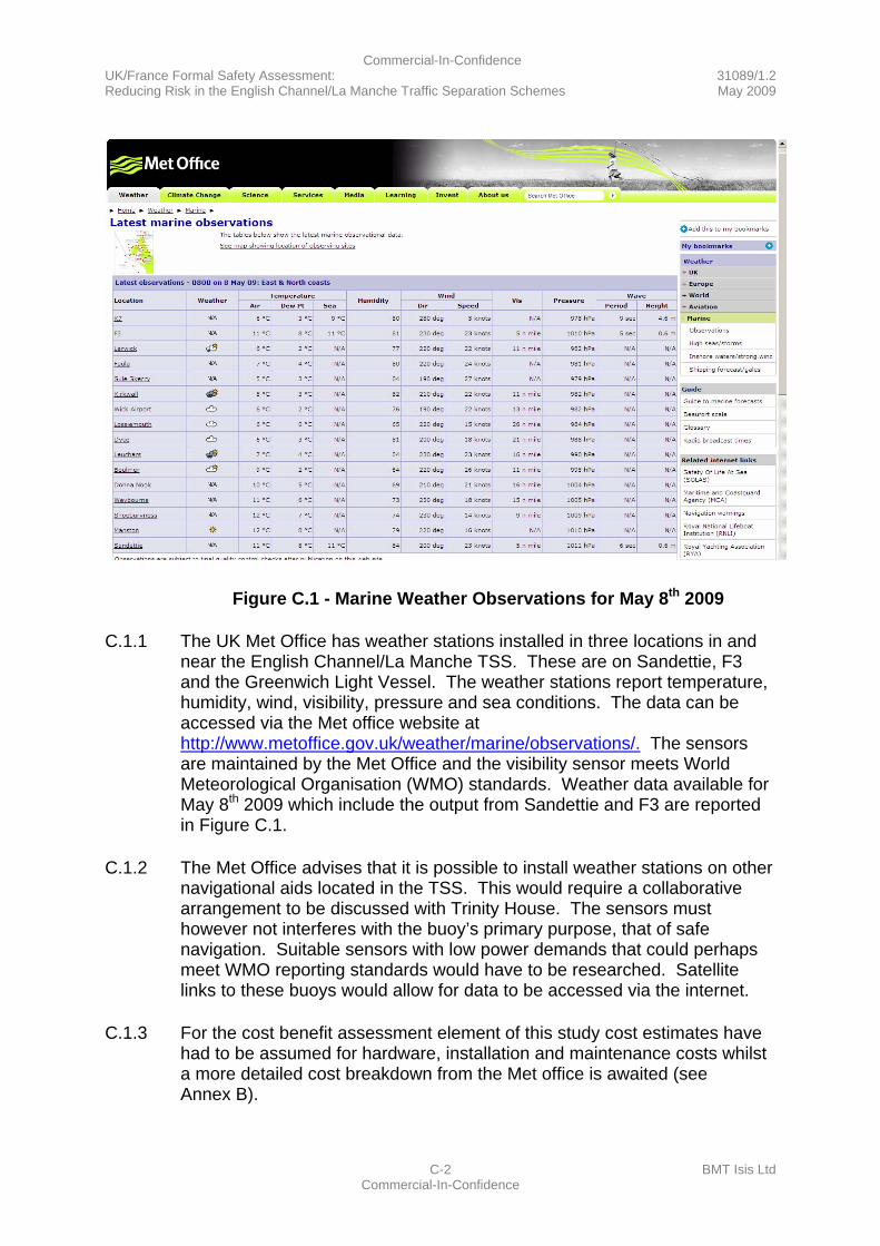
Commercial-In-Confidence UK/France Formal Safety Assessment: 31089/1.2 Reducing Risk in the English Channel/La Manche Traffic Separation Schemes May 2009
C-2 BMT Isis Ltd Commercial-In-Confidence
Figure C.1 - Marine Weather Observations for May 8th 2009
C.1.1 The UK Met Office has weather stations installed in three locations in and near the English Channel/La Manche TSS. These are on Sandettie, F3 and the Greenwich Light Vessel. The weather stations report temperature, humidity, wind, visibility, pressure and sea conditions. The data can be accessed via the Met office website at http://www.metoffice.gov.uk/weather/marine/observations/. The sensors are maintained by the Met Office and the visibility sensor meets World Meteorological Organisation (WMO) standards. Weather data available for May 8th 2009 which include the output from Sandettie and F3 are reported in Figure C.1.
C.1.2 The Met Office advises that it is possible to install weather stations on other navigational aids located in the TSS. This would require a collaborative arrangement to be discussed with Trinity House. The sensors must however not interferes with the buoy’s primary purpose, that of safe navigation. Suitable sensors with low power demands that could perhaps meet WMO reporting standards would have to be researched. Satellite links to these buoys would allow for data to be accessed via the internet.
C.1.3 For the cost benefit assessment element of this study cost estimates have had to be assumed for hardware, installation and maintenance costs whilst a more detailed cost breakdown from the Met office is awaited (see Annex B).
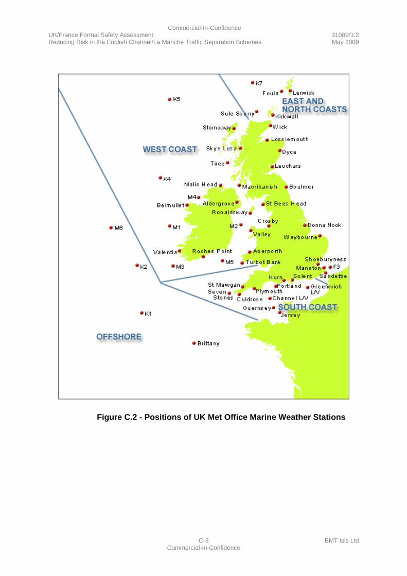
Commercial-In-Confidence UK/France Formal Safety Assessment: 31089/1.2 Reducing Risk in the English Channel/La Manche Traffic Separation Schemes May 2009
C-3 BMT Isis Ltd Commercial-In-Confidence
Figure C.2 - Positions of UK Met Office Marine Weather Stations
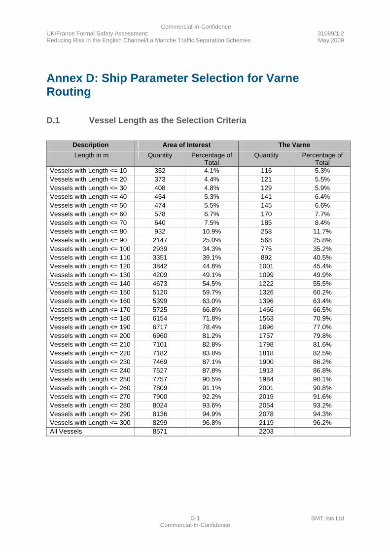
Commercial-In-Confidence UK/France Formal Safety Assessment: 31089/1.2 Reducing Risk in the English Channel/La Manche Traffic Separation Schemes May 2009
D-1 BMT Isis Ltd Commercial-In-Confidence
Annex D: Ship Parameter Selection for Varne Routing
D.1 Vessel Length as the Selection Criteria
Description Area of Interest The Varne Length in m Quantity Percentage of
Total Quantity Percentage of
Total Vessels with Length <= 10 352 4.1% 116 5.3% Vessels with Length <= 20 373 4.4% 121 5.5% Vessels with Length <= 30 408 4.8% 129 5.9% Vessels with Length <= 40 454 5.3% 141 6.4% Vessels with Length <= 50 474 5.5% 145 6.6% Vessels with Length <= 60 578 6.7% 170 7.7% Vessels with Length <= 70 640 7.5% 185 8.4% Vessels with Length <= 80 932 10.9% 258 11.7% Vessels with Length <= 90 2147 25.0% 568 25.8% Vessels with Length <= 100 2939 34.3% 775 35.2% Vessels with Length <= 110 3351 39.1% 892 40.5% Vessels with Length <= 120 3842 44.8% 1001 45.4% Vessels with Length <= 130 4209 49.1% 1099 49.9% Vessels with Length <= 140 4673 54.5% 1222 55.5% Vessels with Length <= 150 5120 59.7% 1326 60.2% Vessels with Length <= 160 5399 63.0% 1396 63.4% Vessels with Length <= 170 5725 66.8% 1466 66.5% Vessels with Length <= 180 6154 71.8% 1563 70.9% Vessels with Length <= 190 6717 78.4% 1696 77.0% Vessels with Length <= 200 6960 81.2% 1757 79.8% Vessels with Length <= 210 7101 82.8% 1798 81.6% Vessels with Length <= 220 7182 83.8% 1818 82.5% Vessels with Length <= 230 7469 87.1% 1900 86.2% Vessels with Length <= 240 7527 87.8% 1913 86.8% Vessels with Length <= 250 7757 90.5% 1984 90.1% Vessels with Length <= 260 7809 91.1% 2001 90.8% Vessels with Length <= 270 7900 92.2% 2019 91.6% Vessels with Length <= 280 8024 93.6% 2054 93.2% Vessels with Length <= 290 8136 94.9% 2078 94.3% Vessels with Length <= 300 8299 96.8% 2119 96.2% All Vessels 8571 2203

Commercial-In-Confidence UK/France Formal Safety Assessment: 31089/1.2 Reducing Risk in the English Channel/La Manche Traffic Separation Schemes May 2009
D-2 BMT Isis Ltd Commercial-In-Confidence
Description North of the Varne South of the Varne Length in m Quantity Percentage of
Total Quantity Percentage of
Total Vessels with Length <= 10 97 5.9% 19 3.3% Vessels with Length <= 20 101 6.2% 20 3.5% Vessels with Length <= 30 108 6.6% 21 3.7% Vessels with Length <= 40 115 7.0% 26 4.6% Vessels with Length <= 50 118 7.2% 27 4.7% Vessels with Length <= 60 135 8.3% 35 6.1% Vessels with Length <= 70 147 9.0% 38 6.7% Vessels with Length <= 80 210 12.9% 48 8.4% Vessels with Length <= 90 482 29.5% 86 15.1% Vessels with Length <= 100 657 40.3% 118 20.7% Vessels with Length <= 110 753 46.1% 139 24.3% Vessels with Length <= 120 839 51.4% 162 28.4% Vessels with Length <= 130 917 56.2% 182 31.9% Vessels with Length <= 140 1021 62.6% 201 35.2% Vessels with Length <= 150 1108 67.9% 218 38.2% Vessels with Length <= 160 1156 70.8% 240 42.0% Vessels with Length <= 170 1203 73.7% 263 46.1% Vessels with Length <= 180 1271 77.9% 292 51.1% Vessels with Length <= 190 1375 84.3% 321 56.2% Vessels with Length <= 200 1414 86.6% 343 60.1% Vessels with Length <= 210 1437 88.1% 361 63.2% Vessels with Length <= 220 1450 88.8% 368 64.4% Vessels with Length <= 230 1500 91.9% 400 70.1% Vessels with Length <= 240 1506 92.3% 407 71.3% Vessels with Length <= 250 1546 94.7% 438 76.7% Vessels with Length <= 260 1554 95.2% 447 78.3% Vessels with Length <= 270 1563 95.8% 456 79.9% Vessels with Length <= 280 1578 96.7% 476 83.4% Vessels with Length <= 290 1589 97.4% 489 85.6% Vessels with Length <= 300 1605 98.3% 514 90.0% All Vessels 1632 571
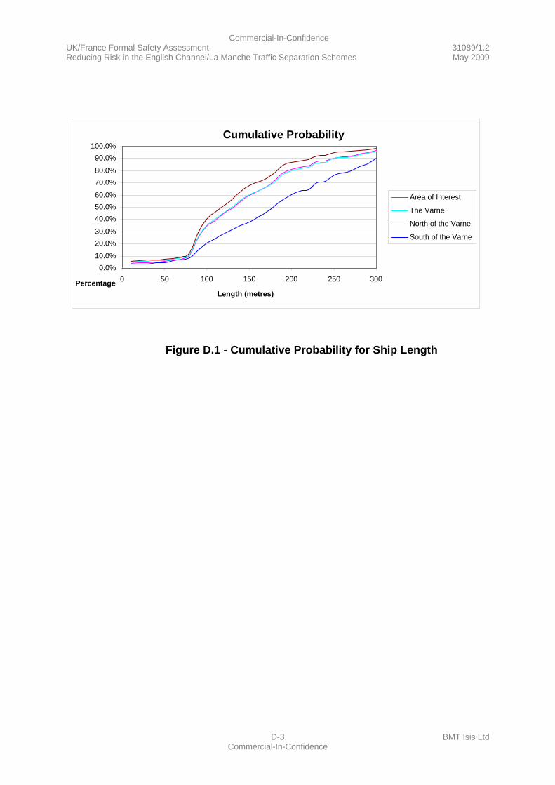
Commercial-In-Confidence UK/France Formal Safety Assessment: 31089/1.2 Reducing Risk in the English Channel/La Manche Traffic Separation Schemes May 2009
D-3 BMT Isis Ltd Commercial-In-Confidence
Figure D.1 - Cumulative Probability for Ship Length
Cumulative Probability
0.0% 10.0% 20.0% 30.0% 40.0% 50.0% 60.0% 70.0% 80.0% 90.0%
100.0%
0 50 100 150 200 250 300
Length (metres)Percentage
Area of Interest
The Varne North of the Varne
South of the Varne
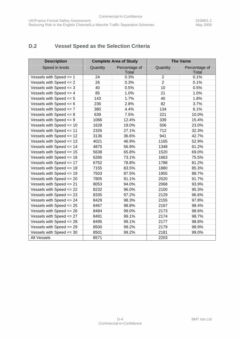
Commercial-In-Confidence UK/France Formal Safety Assessment: 31089/1.2 Reducing Risk in the English Channel/La Manche Traffic Separation Schemes May 2009
D-4 BMT Isis Ltd Commercial-In-Confidence
D.2 Vessel Speed as the Selection Criteria
Description Complete Area of Study The Varne
Speed in knots Quantity Percentage of Total
Quantity Percentage of Total
Vessels with Speed <= 1 24 0.3% 2 0.1% Vessels with Speed <= 2 26 0.3% 2 0.1% Vessels with Speed <= 3 40 0.5% 10 0.5% Vessels with Speed <= 4 85 1.0% 21 1.0% Vessels with Speed <= 5 143 1.7% 40 1.8% Vessels with Speed <= 6 236 2.8% 82 3.7% Vessels with Speed <= 7 380 4.4% 134 6.1% Vessels with Speed <= 8 639 7.5% 221 10.0% Vessels with Speed <= 9 1066 12.4% 339 15.4% Vessels with Speed <= 10 1628 19.0% 506 23.0% Vessels with Speed <= 11 2326 27.1% 712 32.3% Vessels with Speed <= 12 3136 36.6% 941 42.7% Vessels with Speed <= 13 4021 46.9% 1165 52.9% Vessels with Speed <= 14 4875 56.9% 1348 61.2% Vessels with Speed <= 15 5638 65.8% 1520 69.0% Vessels with Speed <= 16 6266 73.1% 1663 75.5% Vessels with Speed <= 17 6752 78.8% 1788 81.2% Vessels with Speed <= 18 7155 83.5% 1880 85.3% Vessels with Speed <= 19 7503 87.5% 1955 88.7% Vessels with Speed <= 20 7805 91.1% 2020 91.7% Vessels with Speed <= 21 8053 94.0% 2068 93.9% Vessels with Speed <= 22 8232 96.0% 2100 95.3% Vessels with Speed <= 23 8335 97.2% 2129 96.6% Vessels with Speed <= 24 8429 98.3% 2155 97.8% Vessels with Speed <= 25 8467 98.8% 2167 98.4% Vessels with Speed <= 26 8484 99.0% 2173 98.6% Vessels with Speed <= 27 8491 99.1% 2174 98.7% Vessels with Speed <= 28 8495 99.1% 2177 98.8% Vessels with Speed <= 29 8500 99.2% 2179 98.9% Vessels with Speed <= 30 8501 99.2% 2181 99.0% All Vessels 8571 2203
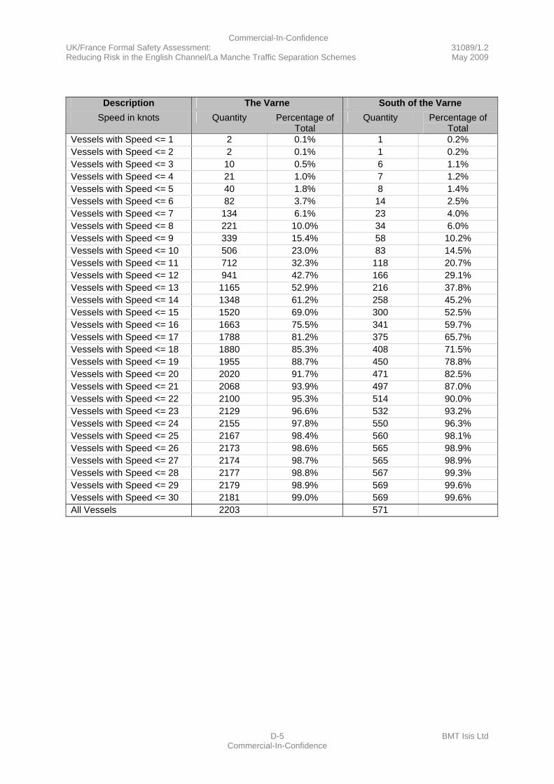
Commercial-In-Confidence UK/France Formal Safety Assessment: 31089/1.2 Reducing Risk in the English Channel/La Manche Traffic Separation Schemes May 2009
D-5 BMT Isis Ltd Commercial-In-Confidence
Description The Varne South of the Varne
Speed in knots Quantity Percentage of Total
Quantity Percentage of Total
Vessels with Speed <= 1 2 0.1% 1 0.2% Vessels with Speed <= 2 2 0.1% 1 0.2% Vessels with Speed <= 3 10 0.5% 6 1.1% Vessels with Speed <= 4 21 1.0% 7 1.2% Vessels with Speed <= 5 40 1.8% 8 1.4% Vessels with Speed <= 6 82 3.7% 14 2.5% Vessels with Speed <= 7 134 6.1% 23 4.0% Vessels with Speed <= 8 221 10.0% 34 6.0% Vessels with Speed <= 9 339 15.4% 58 10.2% Vessels with Speed <= 10 506 23.0% 83 14.5% Vessels with Speed <= 11 712 32.3% 118 20.7% Vessels with Speed <= 12 941 42.7% 166 29.1% Vessels with Speed <= 13 1165 52.9% 216 37.8% Vessels with Speed <= 14 1348 61.2% 258 45.2% Vessels with Speed <= 15 1520 69.0% 300 52.5% Vessels with Speed <= 16 1663 75.5% 341 59.7% Vessels with Speed <= 17 1788 81.2% 375 65.7% Vessels with Speed <= 18 1880 85.3% 408 71.5% Vessels with Speed <= 19 1955 88.7% 450 78.8% Vessels with Speed <= 20 2020 91.7% 471 82.5% Vessels with Speed <= 21 2068 93.9% 497 87.0% Vessels with Speed <= 22 2100 95.3% 514 90.0% Vessels with Speed <= 23 2129 96.6% 532 93.2% Vessels with Speed <= 24 2155 97.8% 550 96.3% Vessels with Speed <= 25 2167 98.4% 560 98.1% Vessels with Speed <= 26 2173 98.6% 565 98.9% Vessels with Speed <= 27 2174 98.7% 565 98.9% Vessels with Speed <= 28 2177 98.8% 567 99.3% Vessels with Speed <= 29 2179 98.9% 569 99.6% Vessels with Speed <= 30 2181 99.0% 569 99.6% All Vessels 2203 571
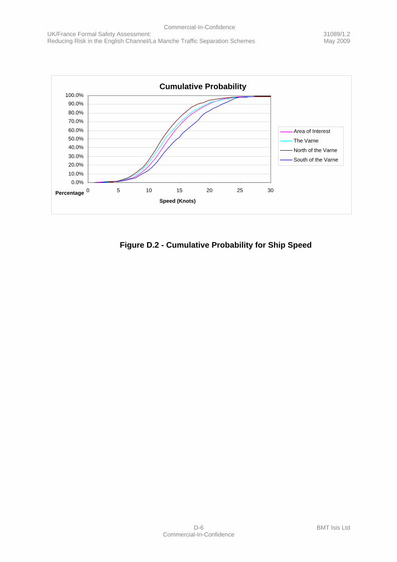
Commercial-In-Confidence UK/France Formal Safety Assessment: 31089/1.2 Reducing Risk in the English Channel/La Manche Traffic Separation Schemes May 2009
D-6 BMT Isis Ltd Commercial-In-Confidence
Figure D.2 - Cumulative Probability for Ship Speed
Cumulative Probability
0.0% 10.0% 20.0% 30.0% 40.0% 50.0% 60.0% 70.0% 80.0% 90.0%
100.0%
0 5 10 15 20 25 30
Speed (Knots)Percentage
Area of Interest
The Varne North of the Varne
South of the Varne
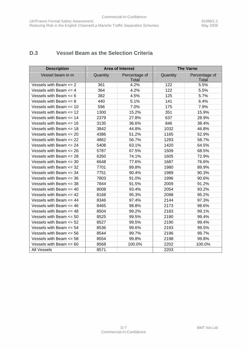
Commercial-In-Confidence UK/France Formal Safety Assessment: 31089/1.2 Reducing Risk in the English Channel/La Manche Traffic Separation Schemes May 2009
D-7 BMT Isis Ltd Commercial-In-Confidence
D.3 Vessel Beam as the Selection Criteria
Description Area of Interest The Varne
Vessel beam in m Quantity Percentage of Total
Quantity Percentage of Total
Vessels with Beam <= 2 361 4.2% 122 5.5% Vessels with Beam <= 4 364 4.2% 122 5.5% Vessels with Beam <= 6 382 4.5% 125 5.7% Vessels with Beam <= 8 440 5.1% 141 6.4% Vessels with Beam <= 10 596 7.0% 175 7.9% Vessels with Beam <= 12 1300 15.2% 351 15.9% Vessels with Beam <= 14 2379 27.8% 637 28.9% Vessels with Beam <= 16 3135 36.6% 846 38.4% Vessels with Beam <= 18 3842 44.8% 1032 46.8% Vessels with Beam <= 20 4386 51.2% 1165 52.9% Vessels with Beam <= 22 4862 56.7% 1293 58.7% Vessels with Beam <= 24 5408 63.1% 1420 64.5% Vessels with Beam <= 26 5787 67.5% 1509 68.5% Vessels with Beam <= 28 6350 74.1% 1605 72.9% Vessels with Beam <= 30 6648 77.6% 1687 76.6% Vessels with Beam <= 32 7701 89.8% 1980 89.9% Vessels with Beam <= 34 7751 90.4% 1989 90.3% Vessels with Beam <= 36 7803 91.0% 1996 90.6% Vessels with Beam <= 38 7844 91.5% 2009 91.2% Vessels with Beam <= 40 8008 93.4% 2054 93.2% Vessels with Beam <= 42 8168 95.3% 2098 95.2% Vessels with Beam <= 44 8346 97.4% 2144 97.3% Vessels with Beam <= 46 8465 98.8% 2173 98.6% Vessels with Beam <= 48 8504 99.2% 2183 99.1% Vessels with Beam <= 50 8525 99.5% 2190 99.4% Vessels with Beam <= 52 8527 99.5% 2190 99.4% Vessels with Beam <= 54 8536 99.6% 2193 99.5% Vessels with Beam <= 56 8544 99.7% 2196 99.7% Vessels with Beam <= 58 8554 99.8% 2198 99.8% Vessels with Beam <= 60 8568 100.0% 2202 100.0% All Vessels 8571 2203
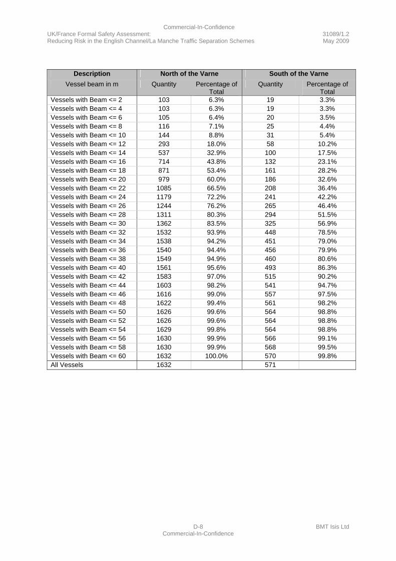
Commercial-In-Confidence UK/France Formal Safety Assessment: 31089/1.2 Reducing Risk in the English Channel/La Manche Traffic Separation Schemes May 2009
D-8 BMT Isis Ltd Commercial-In-Confidence
Description North of the Varne South of the Varne
Vessel beam in m Quantity Percentage of Total
Quantity Percentage of Total
Vessels with Beam <= 2 103 6.3% 19 3.3% Vessels with Beam <= 4 103 6.3% 19 3.3% Vessels with Beam <= 6 105 6.4% 20 3.5% Vessels with Beam <= 8 116 7.1% 25 4.4% Vessels with Beam <= 10 144 8.8% 31 5.4% Vessels with Beam <= 12 293 18.0% 58 10.2% Vessels with Beam <= 14 537 32.9% 100 17.5% Vessels with Beam <= 16 714 43.8% 132 23.1% Vessels with Beam <= 18 871 53.4% 161 28.2% Vessels with Beam <= 20 979 60.0% 186 32.6% Vessels with Beam <= 22 1085 66.5% 208 36.4% Vessels with Beam <= 24 1179 72.2% 241 42.2% Vessels with Beam <= 26 1244 76.2% 265 46.4% Vessels with Beam <= 28 1311 80.3% 294 51.5% Vessels with Beam <= 30 1362 83.5% 325 56.9% Vessels with Beam <= 32 1532 93.9% 448 78.5% Vessels with Beam <= 34 1538 94.2% 451 79.0% Vessels with Beam <= 36 1540 94.4% 456 79.9% Vessels with Beam <= 38 1549 94.9% 460 80.6% Vessels with Beam <= 40 1561 95.6% 493 86.3% Vessels with Beam <= 42 1583 97.0% 515 90.2% Vessels with Beam <= 44 1603 98.2% 541 94.7% Vessels with Beam <= 46 1616 99.0% 557 97.5% Vessels with Beam <= 48 1622 99.4% 561 98.2% Vessels with Beam <= 50 1626 99.6% 564 98.8% Vessels with Beam <= 52 1626 99.6% 564 98.8% Vessels with Beam <= 54 1629 99.8% 564 98.8% Vessels with Beam <= 56 1630 99.9% 566 99.1% Vessels with Beam <= 58 1630 99.9% 568 99.5% Vessels with Beam <= 60 1632 100.0% 570 99.8% All Vessels 1632 571
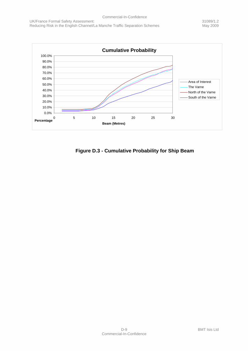
Commercial-In-Confidence UK/France Formal Safety Assessment: 31089/1.2 Reducing Risk in the English Channel/La Manche Traffic Separation Schemes May 2009
D-9 BMT Isis Ltd Commercial-In-Confidence
Figure D.3 - Cumulative Probability for Ship Beam
Cumulative Probability
0.0% 10.0% 20.0% 30.0% 40.0% 50.0% 60.0% 70.0% 80.0% 90.0%
100.0%
0 5 10 15 20 25 30
Beam (Metres)Percentage
Area of InterestThe Varne North of the VarneSouth of the Varne
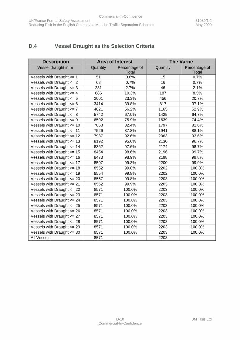
Commercial-In-Confidence UK/France Formal Safety Assessment: 31089/1.2 Reducing Risk in the English Channel/La Manche Traffic Separation Schemes May 2009
D-10 BMT Isis Ltd Commercial-In-Confidence
D.4 Vessel Draught as the Selection Criteria
Description Area of Interest The Varne
Vessel draught in m Quantity Percentage of Total
Quantity Percentage of Total
Vessels with Draught <= 1 51 0.6% 15 0.7% Vessels with Draught <= 2 63 0.7% 16 0.7% Vessels with Draught <= 3 231 2.7% 46 2.1% Vessels with Draught <= 4 886 10.3% 187 8.5% Vessels with Draught <= 5 2001 23.3% 456 20.7% Vessels with Draught <= 6 3414 39.8% 817 37.1% Vessels with Draught <= 7 4821 56.2% 1165 52.9% Vessels with Draught <= 8 5742 67.0% 1425 64.7% Vessels with Draught <= 9 6502 75.9% 1639 74.4% Vessels with Draught <= 10 7063 82.4% 1797 81.6% Vessels with Draught <= 11 7526 87.8% 1941 88.1% Vessels with Draught <= 12 7937 92.6% 2063 93.6% Vessels with Draught <= 13 8192 95.6% 2130 96.7% Vessels with Draught <= 14 8362 97.6% 2174 98.7% Vessels with Draught <= 15 8454 98.6% 2196 99.7% Vessels with Draught <= 16 8473 98.9% 2198 99.8% Vessels with Draught <= 17 8507 99.3% 2200 99.9% Vessels with Draught <= 18 8552 99.8% 2202 100.0% Vessels with Draught <= 19 8554 99.8% 2202 100.0% Vessels with Draught <= 20 8557 99.8% 2203 100.0% Vessels with Draught <= 21 8562 99.9% 2203 100.0% Vessels with Draught <= 22 8571 100.0% 2203 100.0% Vessels with Draught <= 23 8571 100.0% 2203 100.0% Vessels with Draught <= 24 8571 100.0% 2203 100.0% Vessels with Draught <= 25 8571 100.0% 2203 100.0% Vessels with Draught <= 26 8571 100.0% 2203 100.0% Vessels with Draught <= 27 8571 100.0% 2203 100.0% Vessels with Draught <= 28 8571 100.0% 2203 100.0% Vessels with Draught <= 29 8571 100.0% 2203 100.0% Vessels with Draught <= 30 8571 100.0% 2203 100.0% All Vessels 8571 2203
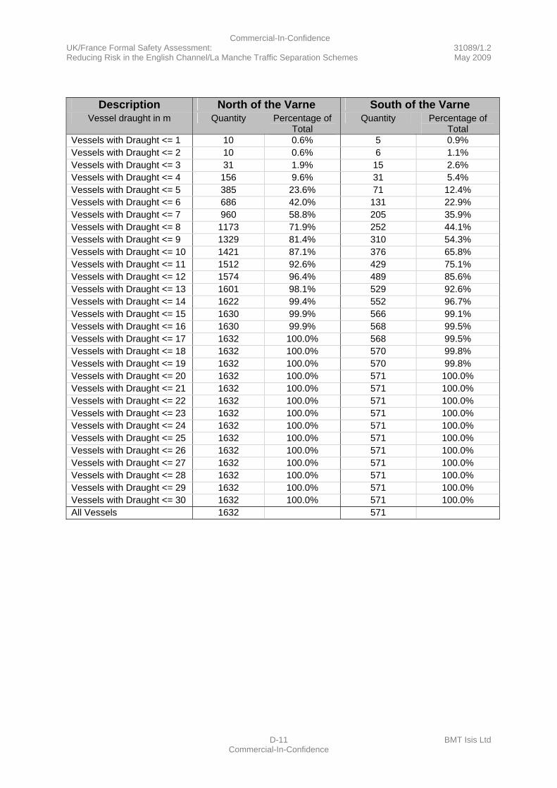
Commercial-In-Confidence UK/France Formal Safety Assessment: 31089/1.2 Reducing Risk in the English Channel/La Manche Traffic Separation Schemes May 2009
D-11 BMT Isis Ltd Commercial-In-Confidence
Description North of the Varne South of the Varne
Vessel draught in m Quantity Percentage of Total
Quantity Percentage of Total
Vessels with Draught <= 1 10 0.6% 5 0.9% Vessels with Draught <= 2 10 0.6% 6 1.1% Vessels with Draught <= 3 31 1.9% 15 2.6% Vessels with Draught <= 4 156 9.6% 31 5.4% Vessels with Draught <= 5 385 23.6% 71 12.4% Vessels with Draught <= 6 686 42.0% 131 22.9% Vessels with Draught <= 7 960 58.8% 205 35.9% Vessels with Draught <= 8 1173 71.9% 252 44.1% Vessels with Draught <= 9 1329 81.4% 310 54.3% Vessels with Draught <= 10 1421 87.1% 376 65.8% Vessels with Draught <= 11 1512 92.6% 429 75.1% Vessels with Draught <= 12 1574 96.4% 489 85.6% Vessels with Draught <= 13 1601 98.1% 529 92.6% Vessels with Draught <= 14 1622 99.4% 552 96.7% Vessels with Draught <= 15 1630 99.9% 566 99.1% Vessels with Draught <= 16 1630 99.9% 568 99.5% Vessels with Draught <= 17 1632 100.0% 568 99.5% Vessels with Draught <= 18 1632 100.0% 570 99.8% Vessels with Draught <= 19 1632 100.0% 570 99.8% Vessels with Draught <= 20 1632 100.0% 571 100.0% Vessels with Draught <= 21 1632 100.0% 571 100.0% Vessels with Draught <= 22 1632 100.0% 571 100.0% Vessels with Draught <= 23 1632 100.0% 571 100.0% Vessels with Draught <= 24 1632 100.0% 571 100.0% Vessels with Draught <= 25 1632 100.0% 571 100.0% Vessels with Draught <= 26 1632 100.0% 571 100.0% Vessels with Draught <= 27 1632 100.0% 571 100.0% Vessels with Draught <= 28 1632 100.0% 571 100.0% Vessels with Draught <= 29 1632 100.0% 571 100.0% Vessels with Draught <= 30 1632 100.0% 571 100.0% All Vessels 1632 571
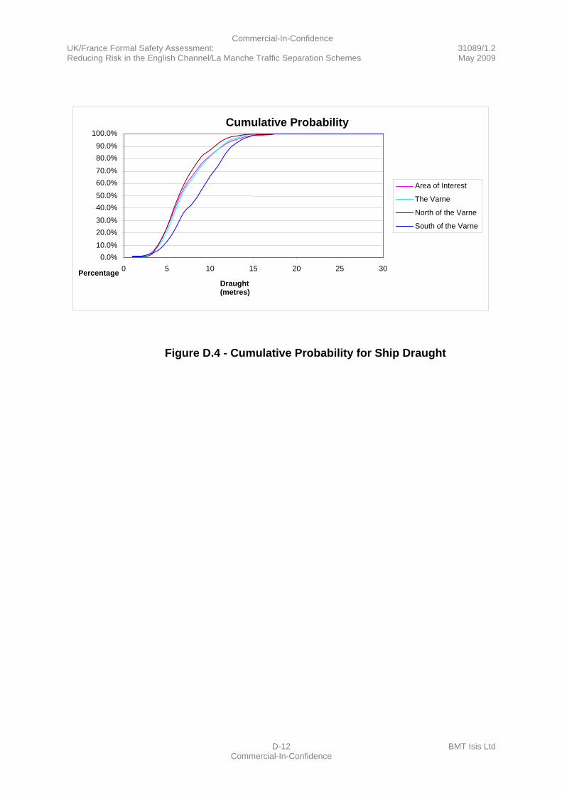
Commercial-In-Confidence UK/France Formal Safety Assessment: 31089/1.2 Reducing Risk in the English Channel/La Manche Traffic Separation Schemes May 2009
D-12 BMT Isis Ltd Commercial-In-Confidence
Figure D.4 - Cumulative Probability for Ship Draught
Cumulative Probability
0.0% 10.0% 20.0% 30.0% 40.0% 50.0% 60.0% 70.0% 80.0% 90.0%
100.0%
0 5 10 15 20 25 30
Draught (metres)
Percentage
Area of Interest
The Varne North of the Varne
South of the Varne