radarsat-2 data - automated high accuracy - pci geomatics
TRANSCRIPT


Ar t ic le
Figure 1b: Orthorectified RADARSAT-2 U2 data using Toutin’s hybrid method without post-processing overlaid with Google Earth
commercial C-band SAR satellite and heralds a Geometric Correction of RADARSAT-2 Since the RADARSAT-2 satellite has multiple GPSnew era in satellite performance, imaging flexi-
bility and product selection and service offer-
ings. In addition to the RADARSAT-1 heritage
modes (Fine, Standard, Wide, ScanSAR Narrow,
ScanSAR Wide, Extended Low and Extended
High), RADARSAT-2 also offers Ultra-Fine, Multi-
Look Fine, Fine Quad-Pol, and Standard Quad-
Pol modes.
Data
For most SAR applications, it is required to
correct the data to a map projection before
it becomes useful. Orthorectification is a com-
mon geometric correction process that
requires the use of a 3D rigorous geometric
model computed from GCPs collected by the
user and a digital elevation model (DEM) to
receivers on board with accurate real-time
positioning, this information could potentially
be used in the accurate geometric processing
and reprojection of RADARSAT-2 data replacing
the need for users to collect GCPs. This would
be a big benefit to a lot of applications where
accurate geometrically-corrected SAR images
are needed as soon as possible for time sen-
sitive applications. In this article, we will
explore the geometric correction accuracy of
different RADARSAT-2 data without user-collect-
ed GCPs using two geometric modeling, i.e.,
the empirical Rational Function Model (RFM)
correct for elevation distortions. However, the
RADARSAT-2 has been designed with significant collection of GCPs can be a significant
and powerful technical advancements: (1) three
to one hundred meters resolution to accom-
modate a wide range of applications. The ultra-
problem in various situations, such as study
regions with no available cartographic data,
no site accessibility, remote areas, feature-
fine mode improves 3D object detection and less terrain (glaciers, desert), timing problem with their rational polynomial coefficients
classification. (2) Flexibility in polarization etc. In these situations, it would be too
selection (HH, HV, VV, and VH) to better dis- expensive to collect new cartographic data
(RPC) and the deterministic 3D Toutin’s mod-
els (original and new hybrid).
criminate various surface types and improve and GCPs in such situations. In addition, the
object detection and recognition. (3) Left and collection of GCPs is almost impossible for RFM/RPC
right-looking imaging options to decrease time sensitive applications, such as flood, RADARSAT-2 data are provided with 3rd-
revisit time for greater monitoring efficiencies. fire, volcanic eruptions or earthquakes, and orderRFM and the numerical values of 80
(4) Solid-state recorders to guarantee image
acquisition anywhere in the world for subse-
quent downlinking with high-capacity (300 Gb)
random access storage. (5) GPS receivers on
board the satellite – provides real-time posi-
tion information to obtain GPS-derived geo-
metric accuracy and greater positional control.
Latest News? Visit www.geoinformatics.com
oil spill monitoring. Furthermore, the GCP
identification and collection process on SAR
images can be much more difficult than on
optical images; a problem exacerbated in
mountainous areas due to SAR-specific geo-
metric effects (foreshortening, layover and
shadow).
23
RPCs. The RFM/RPC, using an empirical/sta-
tistical algorithm developed by MacDonald
Dettwiler and Associates (MDA), approxi-
mates their 3D SAR model of RADARSAT-2. Even
if MDA mentioned that RADARSAT-2 RFM are
extremely accurate in the ability to match a
rigorous zero-Doppler SAR model, because of
July/August 2010

Art ic le
its stability (no issues on attitude variations),
RFM accuracy is still limited by the orbit and
calibration timing uncertainties, which thus
requires these RFM issues with high resolu-
tion SAR data to be addressed. Occasionally
used in the eighties, this RFM/RPC method
received a great deal of renewed attention
with the launch of Space Imaging’s IKONOS
satellite, because its sensor and orbit param-
eters are not included in the image metada-
ta. The RFM/RPC method could thus be an
alternative method to 3D physical models
and it enables users, having little familiarity
Table 1: Systematic (bias) and random errors (Std) over 58 DGPS ICPs of RFM/RPC without post-processing
and new Toutin’s hybrid model
showed good results using post-processed graphic projection. This model has been
RPCs together with one or more GCPs. More recently adapted to the specificity of RADARSAT-
with satellite data, to theoretically perform details about RFM/RPC can be found in the 2 with a decimeter precision. The model is
the geometric correction without GCPs; only
a DEM is required to correct for elevation
distortions in the orthorectification. However,
paper of Grodecki and Dial (PE &RS January,
2003).
user-friendly and robust and has been suc-
cessfully applied with few (3-8) GCPs to visi-
ble infrared (VIR) and SAR data, all around
systematic and random errors still exist after Original Toutin’s 3D physical model the world for the past 20 years. Based upon
applying the RPCs and the results have to The original Toutin’s model is a 3D rigorous good-quality GCPs, the accuracy of the results
be post-processed with 2D polynomial func-
tions (zero to second orders) and several (3-
9) accurate GCPs. The order of the 2D poly-
model developed by Dr.-Ing.Thierry Toutin at was proven to be within one-third of a pixel
Canada Centre for Remote Sensing (CCRS), for medium-resolution VIR images, one to two
Natural Resources Canada, based on princi- pixels for high-resolution VIR images, and
nomial functions to be used in RPC ples related to orbitography, photogramme- within one resolution cell for SAR images. The
post-processing is a function of the type of
data, the viewing angle, the study site and
its relief. Alternatively, the original RPC can
be refined with linear equations and accu-
rate GCPs. Articles in the 2000’s addressing
IKONOS, QuickBird and WorldView data
try, geodesy and cartography. It further reflects only constraint of Toutin’s model is a mini-
the physical reality of the complete viewing mum of 8 pixel-accurate GCPs are required for
geometry and corrects all geometric distor- processing SAR data. More details about the
tions due to platform, sensor and Earth that original Toutin’s model for RADARSAT-2 can be
occur during the imaging process, as well as found in the paper of IEEE-GRSL, April & July
the geometric deformations of the carto- 2009.
Figure 2a: Orthorectified RADARSAT-2 F6 data using RFM/RPC without post-processing overlaid with Google Earth
July/August 2010 24

Ar t ic le
Figure 2b: Orthorectified RADARSAT-2 F6 data using Toutin’s hybrid method overlaid with Google Earth
New Toutin’s hybrid model tests in PCI Geomatics’ operational environ- e.g., without GCPs. PCI Geomatics’ Ortho-
The new Toutin’s hybrid model, being the ment were performed with different modes, Engine (OE) V10.3.2 software was used for
most recent improvement of the original beams, geometry and processing parameters performing these tests. This software supports
Toutin’s model in 2010 for RADARSAT-2, uses the of RADARSAT-2, acquired over four study sites reading of different satellite data, manual or
synergy of both Toutin’s model and the RFM. with various types of terrain, such as automatic GCP/tie (TP) collection, geometric
The metadata, including RFM and RPC, are urban/rural areas with flat-to-mountainous modeling of different satellites using original
used to provide information on the satellite, reliefs: Beauport, Quebec and Toronto, Toutin’s rigorous model, new Toutin’s hybrid
the sensor as well as on the ground. Since
this information is accurate enough, it is the
Ontario in Canada, Morrison, Colorado in USA, model and RFM/RPC, automatic DEM genera-
and Yunnan in China. The authors would like tion and editing, orthorectification, and
either manual or automatic mosaicking
(www.pcigeomatics.com).
Beauport, Canada
Beauport is located north of Quebec City,
only required input into the original Toutin’s to thank Canada Space Agency and MDA for
model to accurately compute all the parame- providing the data and support for this
ters of the model. In addition to obtaining an research. Results and accuracy of these tests
equivalent accuracy to the existing Toutin’s were validated on accurate differential GPS
model, an additional advantage of the new (DGPS) independent check points (ICPs).
hybrid model is its capacity to be applied These results and the ortho-images are now Quebec, Canada. The elevation ranges almost
without collecting GCPs, which increases the
applicability of RADARSAT-2 data in the previ-
ously-mentioned situations. The user, who is
no longer required to collect any GCPs when
using this new hybrid model, will
now be able to generate accurate
presented. While RFM/RPC needs to be post-
processed with several GCPs, the article will
compare this new hybrid model with the
from 10m at the southeast in the city to
around 1000m in the Canadian Shield, locat-
ed to the north. Two RADARSAT-2 ultra-fine
empirical RFM/RPC, but on the same level, mode, single look complex (SLC) (1 by 1 look;
1 64-2.4 by 3m resolution; 1.3 by
.1m spacing) in VV polarization
RADARSAT-2 ortho-images anywhere om descending orbits, with inci-
in the world with an accurate DEM. ence angles of 30.8º - 32º (U2) and
7.5º - 48.3º (U25) at the near-far
RADARSAT-2 Test Data and dges, were acquired on Sept 10
Software nd 14, 2008, respectively. Fifty-
To confirm the previous scientific ght DGPS survey points with 3-D
tests performed at CCRS on the new
Toutin’s hybrid model, additional
Latest News? Visit www.geoinformatics.com
Table 3: RPC Systematic (bias) and random errors (Std) over 4 DGPS ICPs of
RFM/RPC without post-processing and new Toutin’s hybrid model
25
ground accuracy of 10-20 cm were
collected on both images and used
July/August 2010
cartographic applications. The advantages of (1) standard mode (S1), HH and VV polarization,
the new hybrid model are more obvious with ground range at 12.5m image spacing with near-
large geometric distortions, such as U2. far incidence angles of 20.0º to 27.2º; (2) fine
Figure 4: Orthorectified RADARSAT-2 MF1 data using Toutin’s hybrid model overlaid with Google Earth.
26
Art ic le
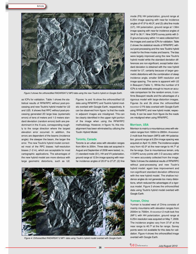
Figure 3 shows the orthorectified RADARSAT-2 MF3 data using the new Toutin’s hybrid on Google Earth.
mode (F6) HH polarization, ground range at
6.25m image spacing with near-far incidence
angles of 47.0º to 49.3º, and (3) ultra fine mode
(U7), HH polarization, ground range at 1.56m
image spacing with near-far incidence angles of
34.8º to 36.1º. Nine DGPS survey points with 3-
D ground accuracy within 1m were collected from
the images and used as ICPs for validation. Table
2 shows the statistical results of RFM/RPC with-
out post-processing and the new Toutin’s hybrid
model for the three modes and beams. The bias
were largely improved using the new Toutin’s
hybrid model while the standard deviation dif-
ferences are non-significant, except better stan-
dard deviation is obtained with the new hybrid
model for U7, certainly because of larger geo-
metric distortions with the combination of steep
incidence angle, smaller SAR resolution and
image spacing. The same is apparent with U2
in Beauport (Table 1). While the number of 9
ICPs is not statistically enough to insure an accu-
rate comparison for the random errors, it con-
firms Beauport results and the advantages of a
as ICPs for validation. Table 1 shows the sta- Figures 1a and 1b show the orthorectified U2 rigorous model with large-distortion images.
tistical results of RFM/RPC without post-pro- data using RFM/RPC and Toutin’s hybrid mod- Figures 2a and 2b show the orthorectified
cessing and new Toutin’s hybrid model for U2 els overlaid with Google Earth, respectively. It RADARSAT-2 F6 data overlaid with Google Earth
and U25. It shows that RPC without post-pro- can be observed from figure 1a that the roads using RFM/RPC and new hybrid model, respec-
cessing generated 2D large bias (systematic in adjacent images are misaligned. This can tively. It can be seen from figure 2a the roads
errors) of tens of meters and 1-2 meters stan-
dard deviation (random errors) both are pre-
dominant in the X-axis, corresponding rough-
be clearly identified in the upper right portion
of the image when using the RFM/RPC
are misaligned when using RFM/RPC.
methodology. However, in figure 1b, this mis- Morrison, USA
ly to the range direction where the largest alignment has been eliminated by utilizing the Morrison is mainly a mountainous area with ele-
elevation error occurred. In addition, the Toutin Hybrid Model. vation ranges from 1600m to 2800m. A RADARSAT-
errors are dependent of the beams (incidence 2 multi-look fine beam (MF3) with HH polariza-
angle): the steeper the beam, the larger the Toronto, Canada tion, ground range at 6.25m image spacing was
error. The new Toutin’s hybrid model correct- Toronto is an urban area with elevation ranges acquired on April 10, 2009. The incidence angles
ed most of the RPC biases: half-resolution from 80m to 200m. Three data set acquired in vary from 42.0º at the near-range to 44.7º at
biases (1-2 m), which are acceptable for most August and September of 2008 were tested, i.e., the far-range. Due to mountainous terrain, only
4 DGPS survey points with 3-D accuracy within
1m were accurately collected from the image.
Table 3 shows the statistical results of RFM/RPC
without post-processing and new Toutin’s
hybrid model: again bias improvement and
non-significant standard deviation difference
with the new hybrid model. The shallow inci-
dence angles do not generate too many distor-
tions, which reduced the advantages of a rigor-
ous model. Figure 3 shows the orthorectified
data using Toutin’s hybrid model overlaid with
Google Earth.
Yunnan, China
Yunnan is located west of China consists of
mainly mountains with elevation ranges from
2000m to 7000m. A RADARSAT-2 multi-look fine
(MF1) with HH polarization, ground range at
6.25m resolution was acquired on May 7, 2009.
The incidence angles vary from 37.6º at the
near range to 40.7º at the far range. Survey
points were not available for this data for vali-
dation. Figure 4 shows the orthorectified image
overlaid with Google Earth.
July/August 2010
Ar t ic le
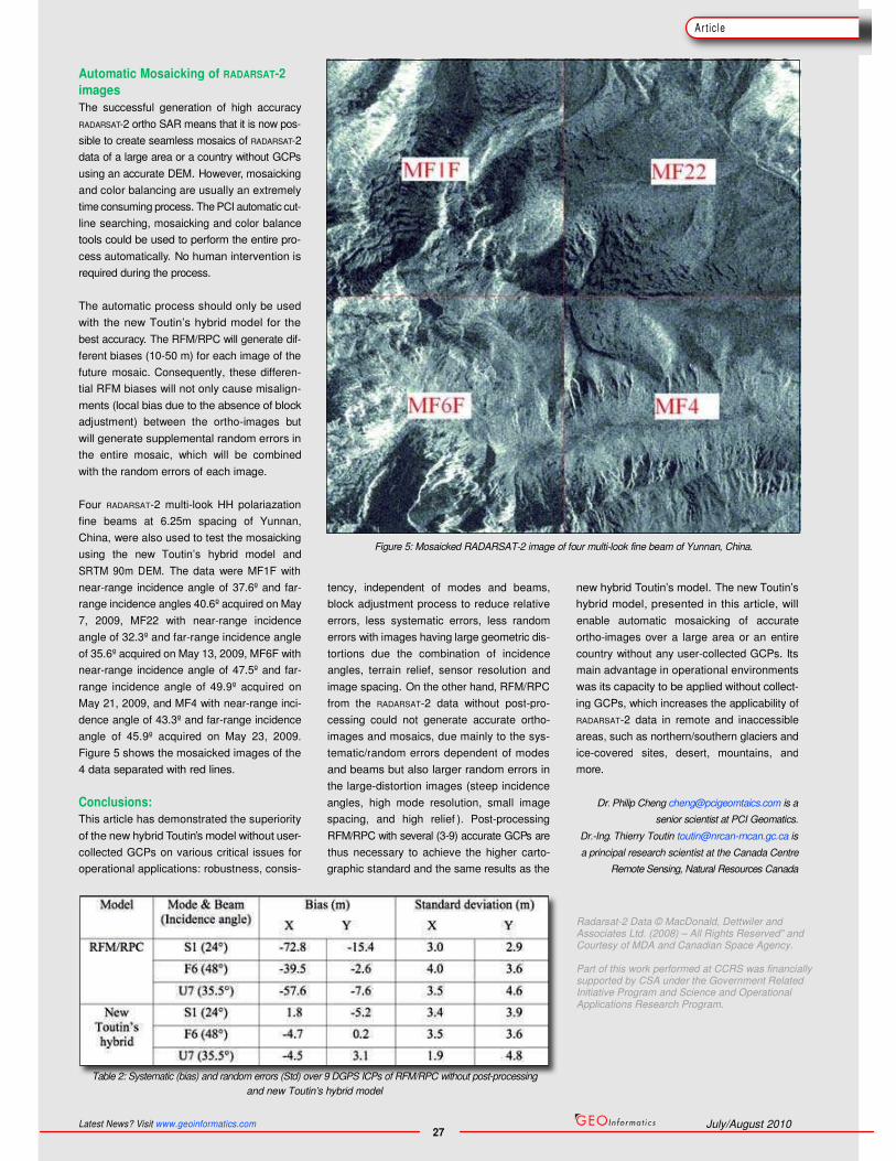
Figure 5: Mosaicked RADARSAT-2 image of four multi-look fine beam of Yunnan, China.
tency, independent of modes and beams, new hybrid Toutin’s model. The new Toutin’s
block adjustment process to reduce relative hybrid model, presented in this article, will
errors, less systematic errors, less random enable automatic mosaicking of accurate
errors with images having large geometric dis- ortho-images over a large area or an entire
tortions due the combination of incidence country without any user-collected GCPs. Its
angles, terrain relief, sensor resolution and main advantage in operational environments
Automatic Mosaicking of RADARSAT-2
images
The successful generation of high accuracy
RADARSAT-2 ortho SAR means that it is now pos-
sible to create seamless mosaics of RADARSAT-2
data of a large area or a country without GCPs
using an accurate DEM. However, mosaicking
and color balancing are usually an extremely
time consuming process. The PCI automatic cut-
line searching, mosaicking and color balance
tools could be used to perform the entire pro-
cess automatically. No human intervention is
required during the process.
The automatic process should only be used
with the new Toutin’s hybrid model for the
best accuracy. The RFM/RPC will generate dif-
ferent biases (10-50 m) for each image of the
future mosaic. Consequently, these differen-
tial RFM biases will not only cause misalign-
ments (local bias due to the absence of block
adjustment) between the ortho-images but
will generate supplemental random errors in
the entire mosaic, which will be combined
with the random errors of each image.
Four RADARSAT-2 multi-look HH polariazation
fine beams at 6.25m spacing of Yunnan,
China, were also used to test the mosaicking
using the new Toutin’s hybrid model and
SRTM 90m DEM. The data were MF1F with
near-range incidence angle of 37.6º and far-
range incidence angles 40.6º acquired on May
7, 2009, MF22 with near-range incidence
angle of 32.3º and far-range incidence angle
of 35.6º acquired on May 13, 2009, MF6F with
near-range incidence angle of 47.5º and far-
range incidence angle of 49.9º acquired on image spacing. On the other hand, RFM/RPC was its capacity to be applied without collect-
May 21, 2009, and MF4 with near-range inci-
dence angle of 43.3º and far-range incidence
angle of 45.9º acquired on May 23, 2009.
Figure 5 shows the mosaicked images of the
4 data separated with red lines.
from the RADARSAT-2 data without post-pro- ing GCPs, which increases the applicability of
cessing could not generate accurate ortho- RADARSAT-2 data in remote and inaccessible
images and mosaics, due mainly to the sys- areas, such as northern/southern glaciers and
tematic/random errors dependent of modes
and beams but also larger random errors in
the large-distortion images (steep incidence
ice-covered sites, desert, mountains, and
more.
Conclusions: angles, high mode resolution, small image Dr. Philip Cheng [email protected] is a
This article has demonstrated the superiority spacing, and high relief ). Post-processing senior scientist at PCI Geomatics.
of the new hybrid Toutin’s model without user- RFM/RPC with several (3-9) accurate GCPs are Dr.-Ing. Thierry Toutin [email protected] is
collected GCPs on various critical issues for thus necessary to achieve the higher carto- a principal research scientist at the Canada Centre
operational applications: robustness, consis- graphic standard and the same results as the Remote Sensing, Natural Resources Canada
Table 2: Systematic (bias) and random errors (Std) over 9 DGPS ICPs of RFM/RPC without post-processing
and new Toutin’s hybrid model
Latest News? Visit www.geoinformatics.com 27
July/August 2010
Radarsat-2 Data © MacDonald, Dettwiler and Associates Ltd. (2008) – All Rights Reserved" and Courtesy of MDA and Canadian Space Agency. Part of this work performed at CCRS was financially supported by CSA under the Government Related Initiative Program and Science and Operational Applications Research Program.