geomatics for conservation & communication of … · geomatics for conservation &...
TRANSCRIPT
GEOMATICS FOR CONSERVATION & COMMUNICATION OF CULTURAL HERITAGE LABORATORY
| [email protected] | 3D SCANNING SYSTEMS | 1
There is no generally accepted definition concerning instruments which are considered to be 3D scanners. Some classification will be proposed.
3D SCANNER: is any device that
- collects 3D coordinates of a given region of an object surface
- automatically and in a systematic pattern
- at a high rate
- achieving the results (i.e. 3D coordinates) in (near) real time.
DEFINITIONS
GEOMATICS FOR CONSERVATION & COMMUNICATION OF CULTURAL HERITAGE LABORATORY
| [email protected] | 3D SCANNING SYSTEMS | 2
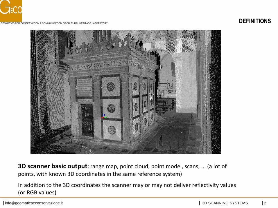
3D scanner basic output: range map, point cloud, point model, scans, ... (a lot of points, with known 3D coordinates in the same reference system)
In addition to the 3D coordinates the scanner may or may not deliver reflectivity values (or RGB values)
DEFINITIONS
GEOMATICS FOR CONSERVATION & COMMUNICATION OF CULTURAL HERITAGE LABORATORY
| [email protected] | 3D SCANNING SYSTEMS | 3
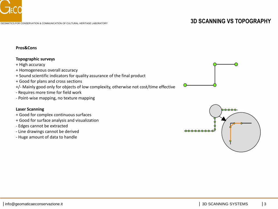
Pros&Cons Topographic surveys + High accuracy + Homogeneous overall accuracy + Sound scientific indicators for quality assurance of the final product + Good for plans and cross sections +/- Mainly good only for objects of low complexity, otherwise not cost/time effective - Requires more time for field work - Point-wise mapping, no texture mapping Laser Scanning + Good for complex continuous surfaces + Good for surface analysis and visualization - Edges cannot be extracted - Line drawings cannot be derived - Huge amount of data to handle
3D SCANNING VS TOPOGRAPHY
GEOMATICS FOR CONSERVATION & COMMUNICATION OF CULTURAL HERITAGE LABORATORY
| [email protected] | 3D SCANNING SYSTEMS | 4
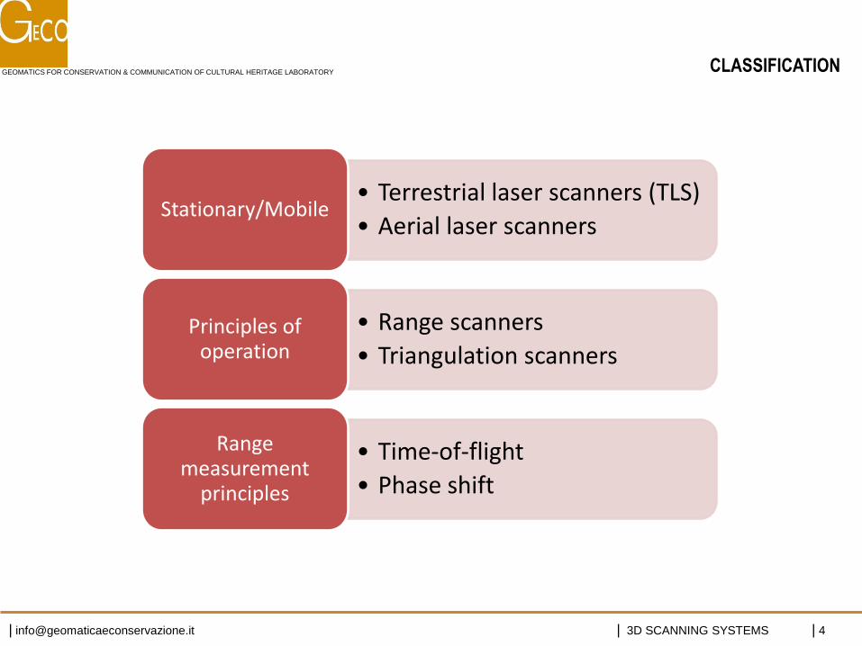
• Terrestrial laser scanners (TLS)
• Aerial laser scanners Stationary/Mobile
• Range scanners
• Triangulation scanners Principles of
operation
• Time-of-flight
• Phase shift
Range measurement
principles
CLASSIFICATION
GEOMATICS FOR CONSERVATION & COMMUNICATION OF CULTURAL HERITAGE LABORATORY
| [email protected] | 3D SCANNING SYSTEMS | 5 http://www.acfr.usyd.edu.au/
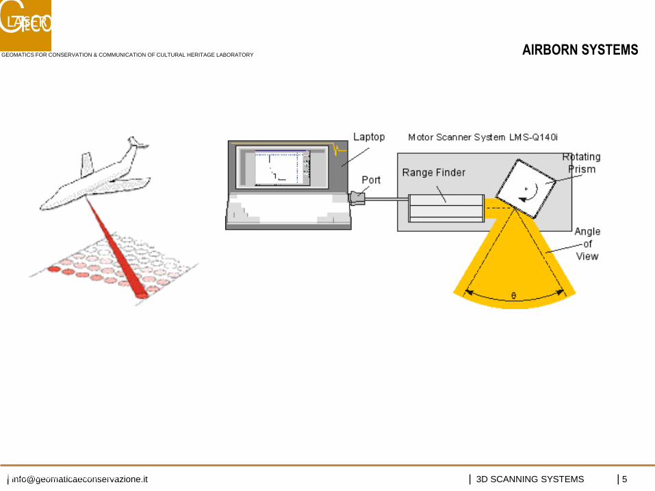
LASER AEREI
AIRBORN SYSTEMS
GEOMATICS FOR CONSERVATION & COMMUNICATION OF CULTURAL HERITAGE LABORATORY
| [email protected] | 3D SCANNING SYSTEMS | 6 http://www.acfr.usyd.edu.au/
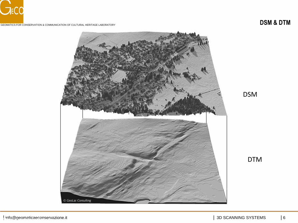
DSM
DTM
DSM & DTM
GEOMATICS FOR CONSERVATION & COMMUNICATION OF CULTURAL HERITAGE LABORATORY
| [email protected] | 3D SCANNING SYSTEMS | 7
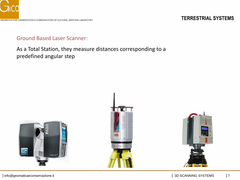
TERRESTRIAL SYSTEMS
Ground Based Laser Scanner:
As a Total Station, they measure distances corresponding to a predefined angular step
GEOMATICS FOR CONSERVATION & COMMUNICATION OF CULTURAL HERITAGE LABORATORY
| [email protected] | 3D SCANNING SYSTEMS | 8
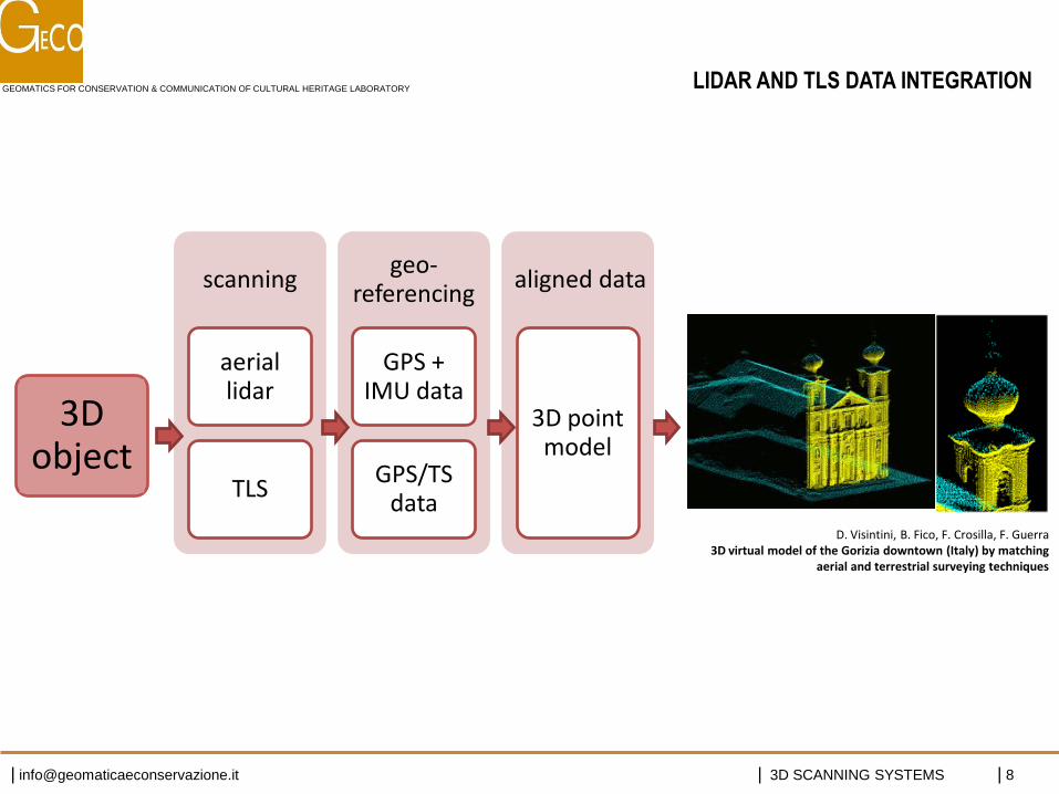
scanning
aerial lidar
TLS
geo-referencing
GPS + IMU data
GPS/TS data
aligned data
3D point model
3D object
D. Visintini, B. Fico, F. Crosilla, F. Guerra 3D virtual model of the Gorizia downtown (Italy) by matching
aerial and terrestrial surveying techniques
LIDAR AND TLS DATA INTEGRATION
GEOMATICS FOR CONSERVATION & COMMUNICATION OF CULTURAL HERITAGE LABORATORY
| [email protected] | 3D SCANNING SYSTEMS | 9
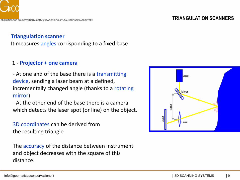
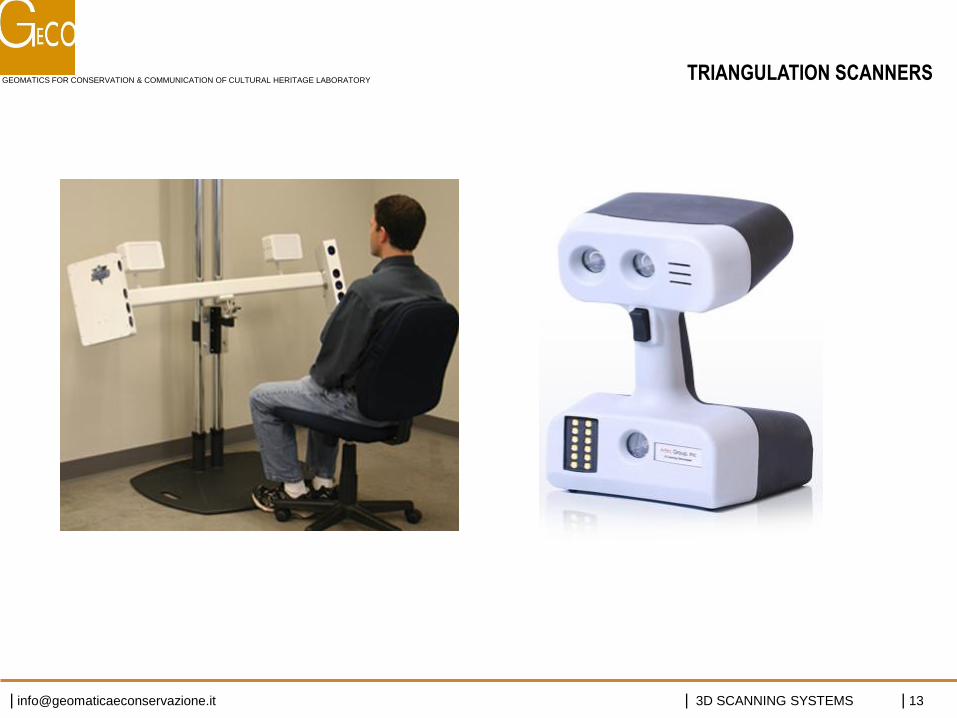
- At one and of the base there is a transmitting device, sending a laser beam at a defined, incrementally changed angle (thanks to a rotating mirror) - At the other end of the base there is a camera which detects the laser spot (or line) on the object. 3D coordinates can be derived from the resulting triangle The accuracy of the distance between instrument and object decreases with the square of this distance.
Triangulation scanner It measures angles corrisponding to a fixed base
- 1 - Projector + one camera:
TRIANGULATION SCANNERS
GEOMATICS FOR CONSERVATION & COMMUNICATION OF CULTURAL HERITAGE LABORATORY
| [email protected] | 3D SCANNING SYSTEMS | 10
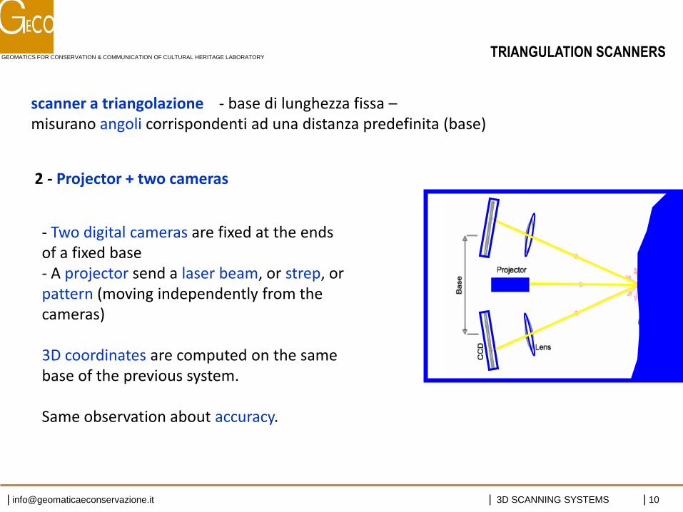
- Two digital cameras are fixed at the ends of a fixed base - A projector send a laser beam, or strep, or pattern (moving independently from the cameras) 3D coordinates are computed on the same base of the previous system. Same observation about accuracy.
scanner a triangolazione - base di lunghezza fissa – misurano angoli corrispondenti ad una distanza predefinita (base)
TRIANGULATION SCANNERS
- 2 - Projector + two cameras:
GEOMATICS FOR CONSERVATION & COMMUNICATION OF CULTURAL HERITAGE LABORATORY
| [email protected] | 3D SCANNING SYSTEMS | 11
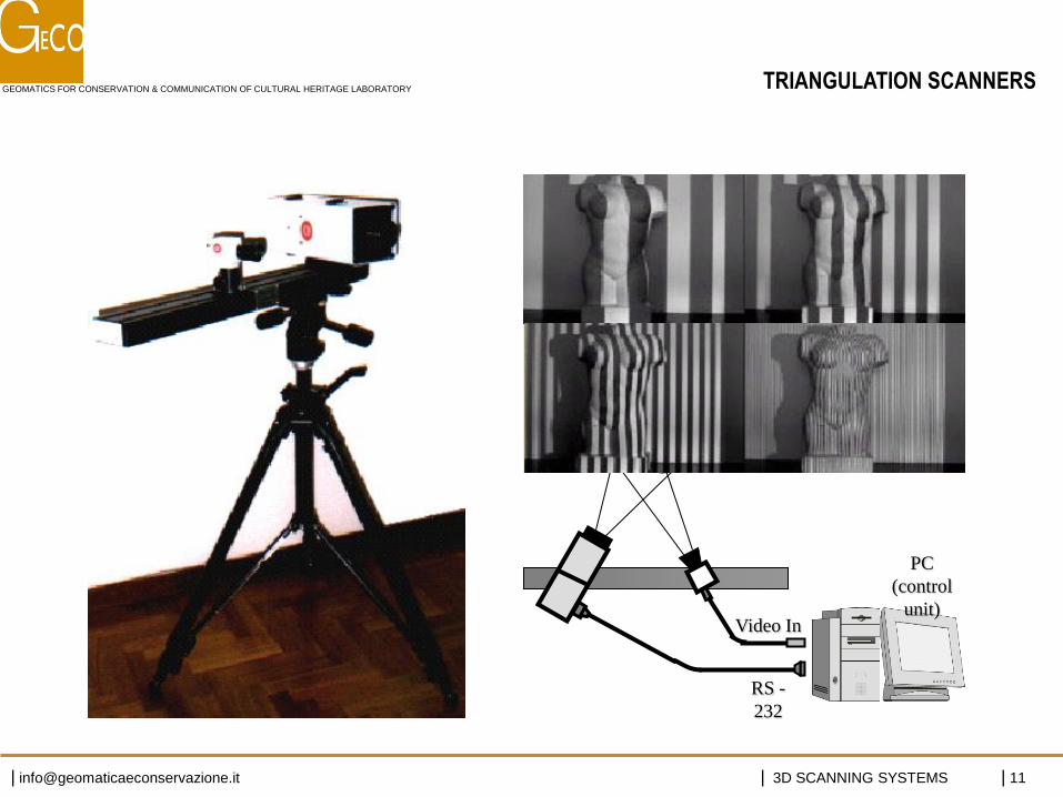
Video In
RS -
232
Object
PC
(control
unit)
TRIANGULATION SCANNERS
GEOMATICS FOR CONSERVATION & COMMUNICATION OF CULTURAL HERITAGE LABORATORY
| [email protected] | 3D SCANNING SYSTEMS | 12
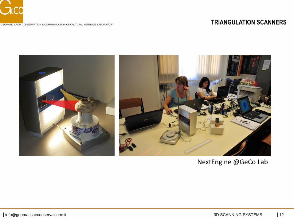
NextEngine @GeCo Lab
TRIANGULATION SCANNERS
GEOMATICS FOR CONSERVATION & COMMUNICATION OF CULTURAL HERITAGE LABORATORY
| [email protected] | 3D SCANNING SYSTEMS | 13
TRIANGULATION SCANNERS
GEOMATICS FOR CONSERVATION & COMMUNICATION OF CULTURAL HERITAGE LABORATORY
| [email protected] | 3D SCANNING SYSTEMS | 14
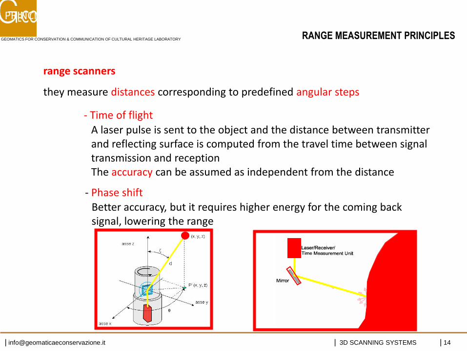
range scanners
they measure distances corresponding to predefined angular steps
A laser pulse is sent to the object and the distance between transmitter and reflecting surface is computed from the travel time between signal transmission and reception The accuracy can be assumed as independent from the distance
- Time of flight
- Phase shift Better accuracy, but it requires higher energy for the coming back signal, lowering the range
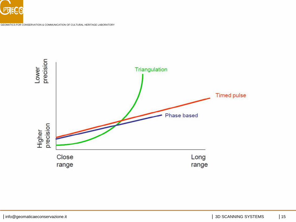
PRINCIPI di FUNZIONAMENTO
RANGE MEASUREMENT PRINCIPLES
GEOMATICS FOR CONSERVATION & COMMUNICATION OF CULTURAL HERITAGE LABORATORY
| [email protected] | 3D SCANNING SYSTEMS | 15
PRECISIONI e PORTATE
GEOMATICS FOR CONSERVATION & COMMUNICATION OF CULTURAL HERITAGE LABORATORY
| [email protected] | 3D SCANNING SYSTEMS | 16
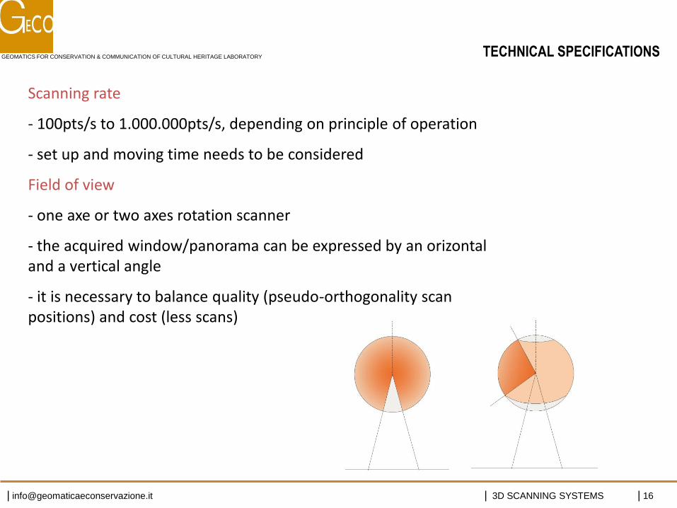
TECHNICAL SPECIFICATIONS
Scanning rate
- 100pts/s to 1.000.000pts/s, depending on principle of operation
- set up and moving time needs to be considered
Field of view
- one axe or two axes rotation scanner
- the acquired window/panorama can be expressed by an orizontal and a vertical angle
- it is necessary to balance quality (pseudo-orthogonality scan positions) and cost (less scans)
GEOMATICS FOR CONSERVATION & COMMUNICATION OF CULTURAL HERITAGE LABORATORY
| [email protected] | 3D SCANNING SYSTEMS | 17
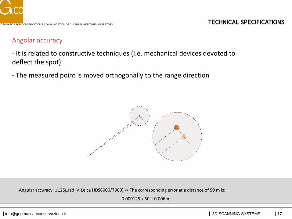
Angolar accuracy
- It is related to constructive techniques (i.e. mechanical devices devoted to deflect the spot)
- The measured point is moved orthogonally to the range direction
Angular accuracy: ±125µrad (v. Leica HDS6000/7000) -> The corresponding error at a distance of 50 m is:
0.000125 x 50 ~ 0.006m
TECHNICAL SPECIFICATIONS
GEOMATICS FOR CONSERVATION & COMMUNICATION OF CULTURAL HERITAGE LABORATORY
| [email protected] | 3D SCANNING SYSTEMS | 18
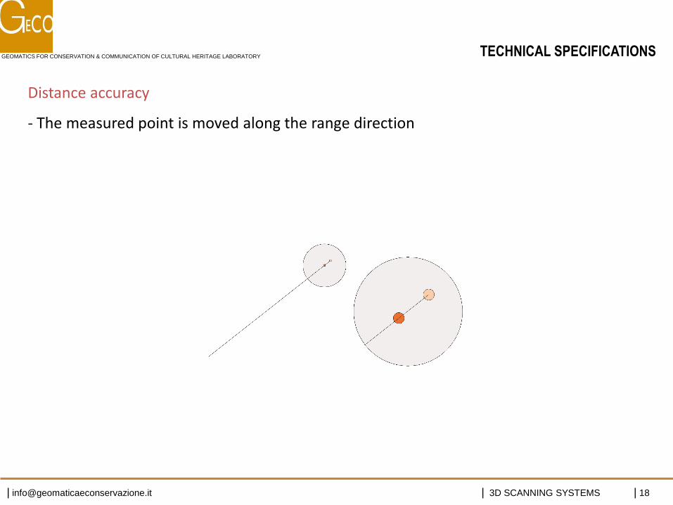
Distance accuracy
- The measured point is moved along the range direction
TECHNICAL SPECIFICATIONS
GEOMATICS FOR CONSERVATION & COMMUNICATION OF CULTURAL HERITAGE LABORATORY
| [email protected] | 3D SCANNING SYSTEMS | 19
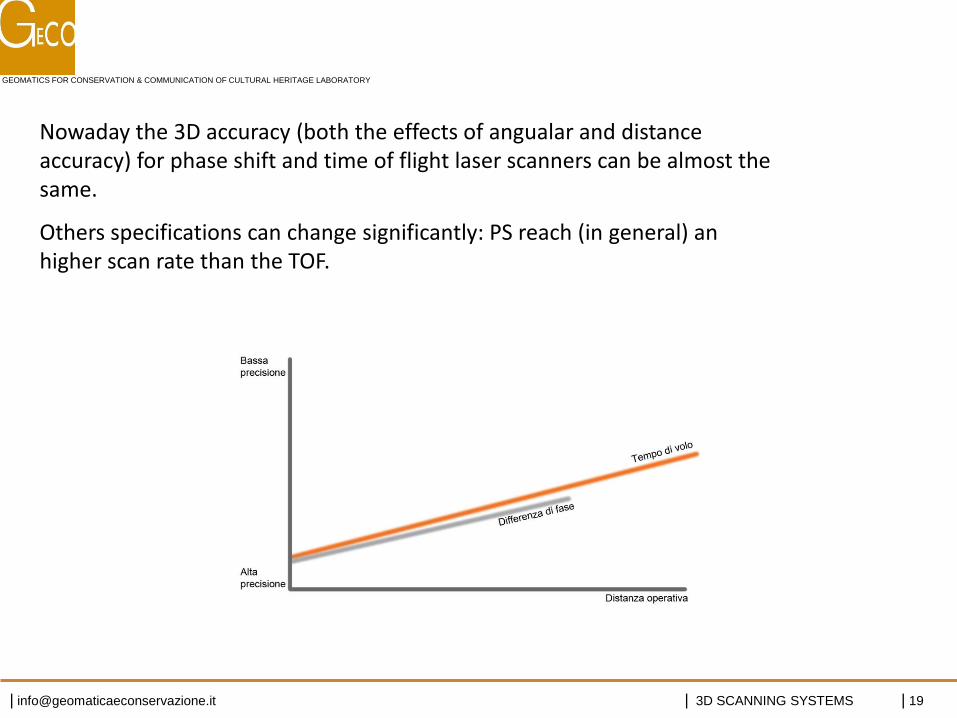
Nowaday the 3D accuracy (both the effects of angualar and distance accuracy) for phase shift and time of flight laser scanners can be almost the same.
Others specifications can change significantly: PS reach (in general) an higher scan rate than the TOF.
GEOMATICS FOR CONSERVATION & COMMUNICATION OF CULTURAL HERITAGE LABORATORY
| [email protected] | 3D SCANNING SYSTEMS | 20
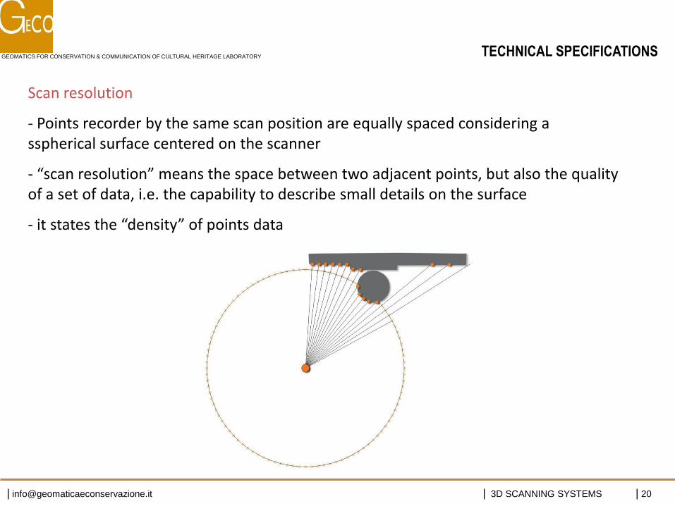
Scan resolution
- Points recorder by the same scan position are equally spaced considering a sspherical surface centered on the scanner
- “scan resolution” means the space between two adjacent points, but also the quality of a set of data, i.e. the capability to describe small details on the surface
- it states the “density” of points data
TECHNICAL SPECIFICATIONS
GEOMATICS FOR CONSERVATION & COMMUNICATION OF CULTURAL HERITAGE LABORATORY
| [email protected] | 3D SCANNING SYSTEMS | 21
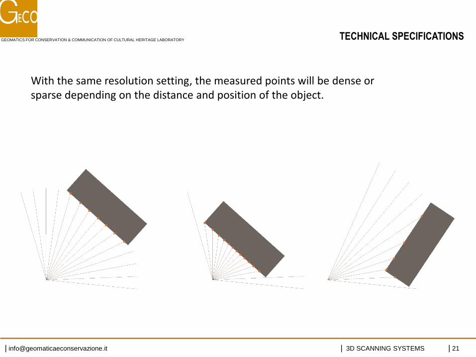
With the same resolution setting, the measured points will be dense or sparse depending on the distance and position of the object.
TECHNICAL SPECIFICATIONS
GEOMATICS FOR CONSERVATION & COMMUNICATION OF CULTURAL HERITAGE LABORATORY
| [email protected] | 3D SCANNING SYSTEMS | 22
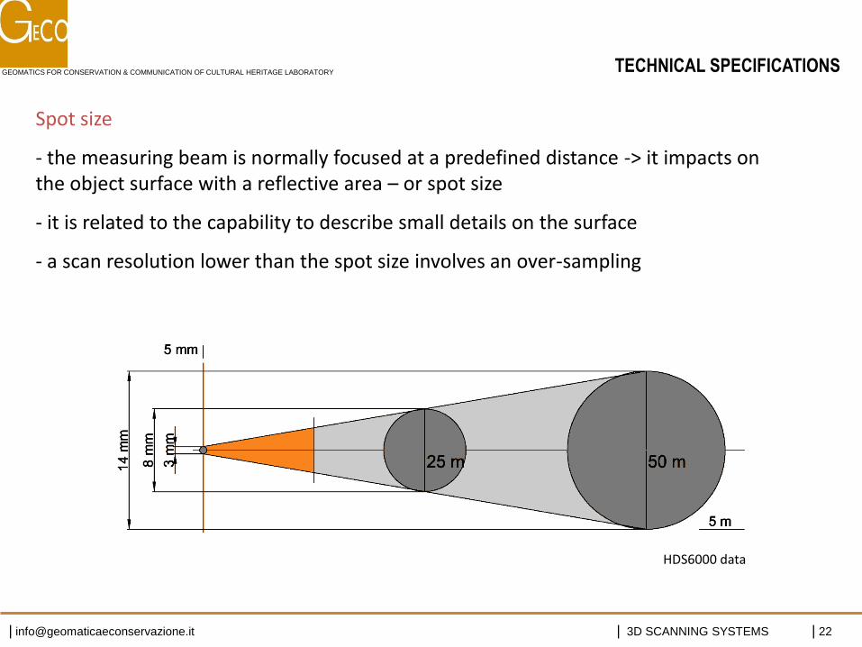
Spot size
- the measuring beam is normally focused at a predefined distance -> it impacts on the object surface with a reflective area – or spot size
- it is related to the capability to describe small details on the surface
- a scan resolution lower than the spot size involves an over-sampling
HDS6000 data
TECHNICAL SPECIFICATIONS
GEOMATICS FOR CONSERVATION & COMMUNICATION OF CULTURAL HERITAGE LABORATORY
| [email protected] | 3D SCANNING SYSTEMS | 23
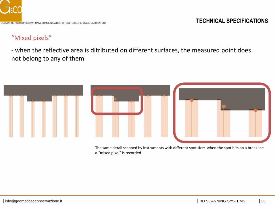
“Mixed pixels”
- when the reflective area is ditributed on different surfaces, the measured point does not belong to any of them
The same detail scanned by instruments with different spot size: when the spot hits on a breakline a “mixed pixel” is recorded
TECHNICAL SPECIFICATIONS
GEOMATICS FOR CONSERVATION & COMMUNICATION OF CULTURAL HERITAGE LABORATORY
| [email protected] | 3D SCANNING SYSTEMS | 24
Real ranges
- depends on material, roughness, colors, wetness, angle of incidence …
Reflectivity value
- Useful to better understanding the point model
- Allow to automatically recognize specific targets
Some biases have been observed, due to material and chromatic characteristics of the surface: unfavorable conditions are scan positions almost orthogonal to highly reflective surfaces, and scans facing the sun
(a digital camera can be combined to the scan head)
TECHNICAL SPECIFICATIONS

GEOMATICS FOR CONSERVATION & COMMUNICATION OF CULTURAL HERITAGE LABORATORY
| [email protected] | 3D SCANNING SYSTEMS | 25
TECHNICAL SPECIFICATIONS
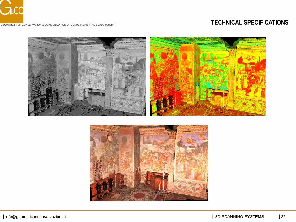
GEOMATICS FOR CONSERVATION & COMMUNICATION OF CULTURAL HERITAGE LABORATORY
| [email protected] | 3D SCANNING SYSTEMS | 26
TECHNICAL SPECIFICATIONS
GEOMATICS FOR CONSERVATION & COMMUNICATION OF CULTURAL HERITAGE LABORATORY
| [email protected] | 3D SCANNING SYSTEMS | 27
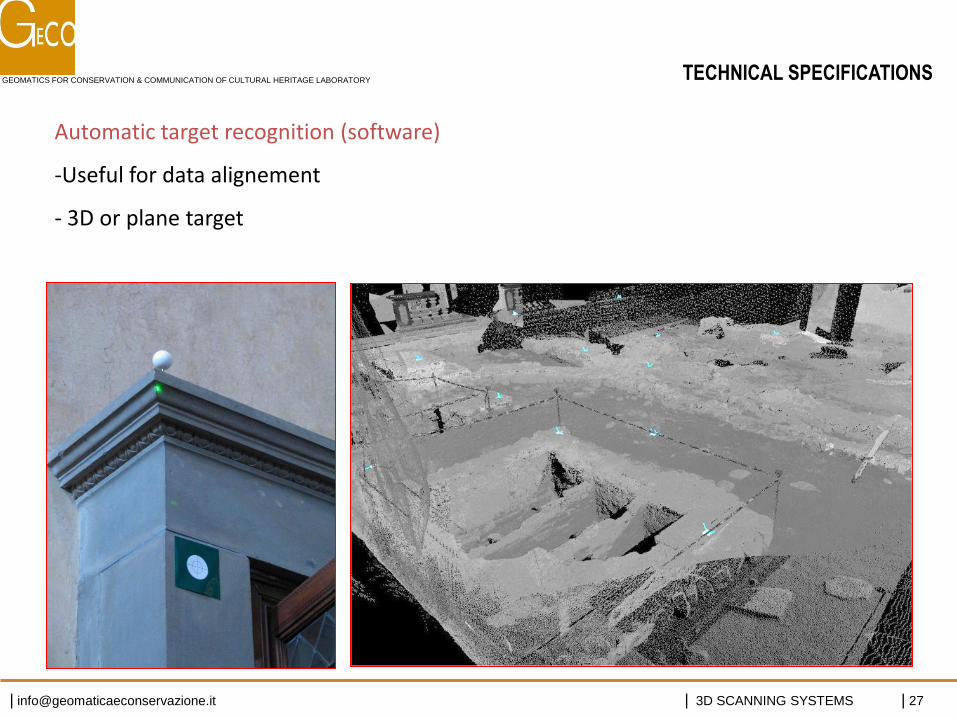
Automatic target recognition (software)
-Useful for data alignement
- 3D or plane target
TECHNICAL SPECIFICATIONS
GEOMATICS FOR CONSERVATION & COMMUNICATION OF CULTURAL HERITAGE LABORATORY
| [email protected] | 3D SCANNING SYSTEMS | 28
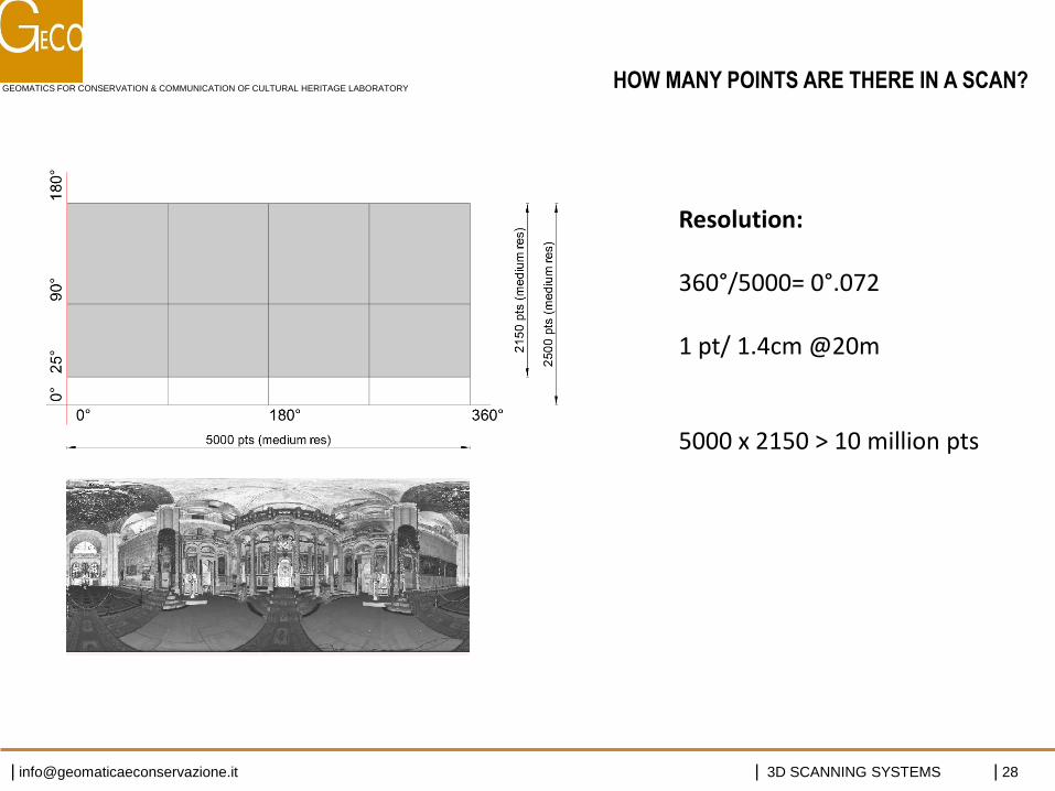
HOW MANY POINTS ARE THERE IN A SCAN?
Resolution: 360°/5000= 0°.072 1 pt/ 1.4cm @20m 5000 x 2150 > 10 million pts

GEOMATICS FOR CONSERVATION & COMMUNICATION OF CULTURAL HERITAGE LABORATORY
| [email protected] | 3D SCANNING SYSTEMS | 29
Un modello è un referente significativo dell’oggetto (sostituto della realtà semplificato/sintetico): per descriverlo elimina gli elementi ridondanti e enfatizza quelli ritenuti più importanti
Un modello di punti è proprio l’opposto, essendo costituito da elementi ridondanti ed indifferenziati.
Gli elaborati che derivano dalle operazioni di misura : “non ricreano l’oggetto nella sua integrità ma ne danno una caricatura maligna” [M. Cunietti]
MODELLO DI PUNTI
GEOMATICS FOR CONSERVATION & COMMUNICATION OF CULTURAL HERITAGE LABORATORY
| [email protected] | 3D SCANNING SYSTEMS | 30
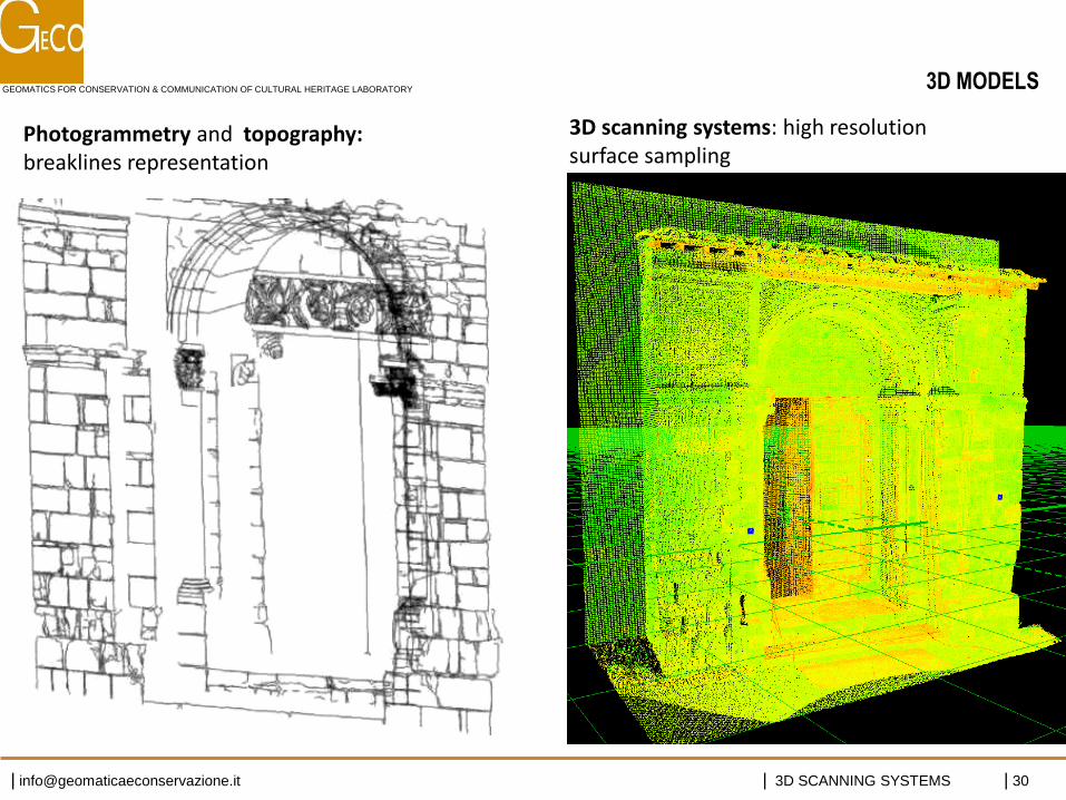
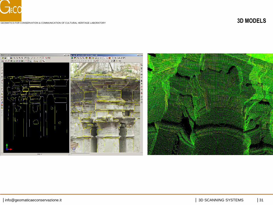
Photogrammetry and topography: breaklines representation
3D scanning systems: high resolution surface sampling
3D MODELS
GEOMATICS FOR CONSERVATION & COMMUNICATION OF CULTURAL HERITAGE LABORATORY
| [email protected] | 3D SCANNING SYSTEMS | 31
3D MODELS
GEOMATICS FOR CONSERVATION & COMMUNICATION OF CULTURAL HERITAGE LABORATORY
| [email protected] | 3D SCANNING SYSTEMS | 32
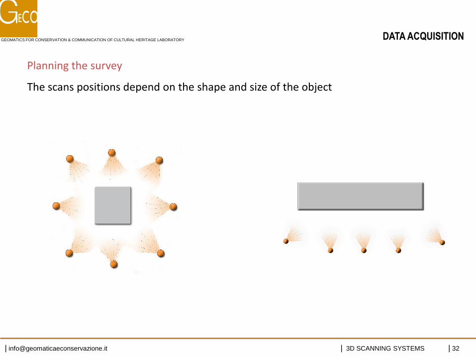
DATA ACQUISITION
Planning the survey
The scans positions depend on the shape and size of the object
GEOMATICS FOR CONSERVATION & COMMUNICATION OF CULTURAL HERITAGE LABORATORY
| [email protected] | 3D SCANNING SYSTEMS | 33
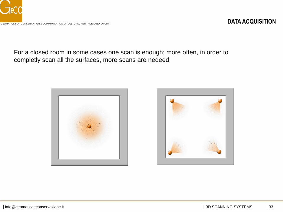
For a closed room in some cases one scan is enough; more often, in order to
completly scan all the surfaces, more scans are nedeed.
DATA ACQUISITION
GEOMATICS FOR CONSERVATION & COMMUNICATION OF CULTURAL HERITAGE LABORATORY
| [email protected] | 3D SCANNING SYSTEMS | 34
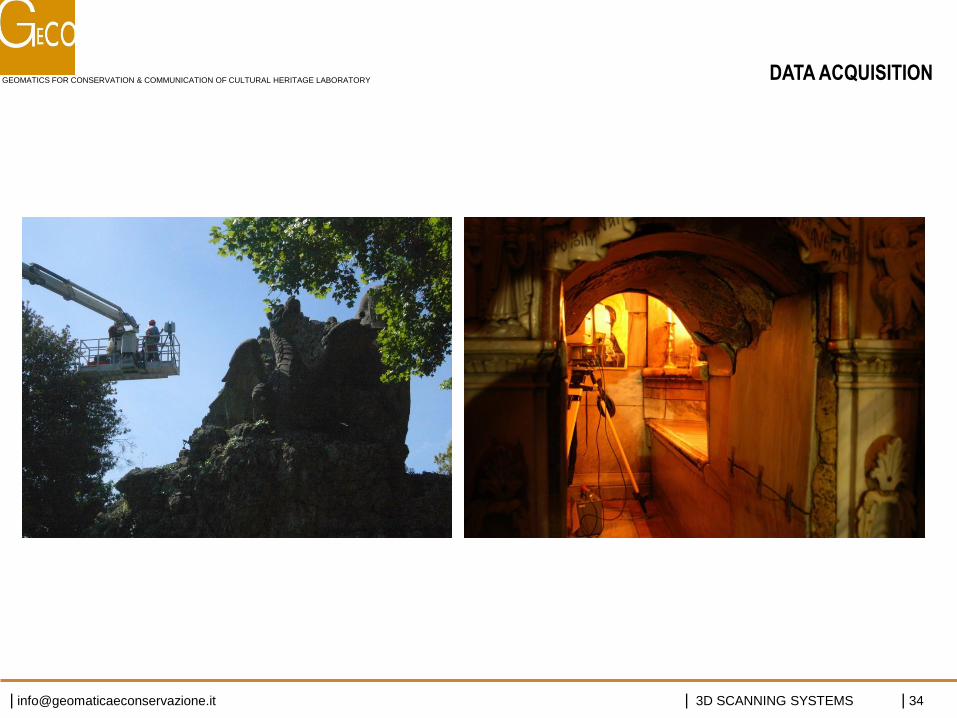
DATA ACQUISITION
GEOMATICS FOR CONSERVATION & COMMUNICATION OF CULTURAL HERITAGE LABORATORY
| [email protected] | 3D SCANNING SYSTEMS | 35
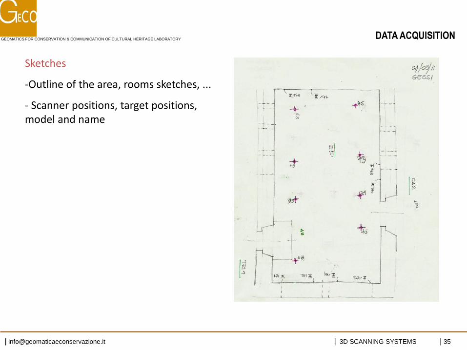
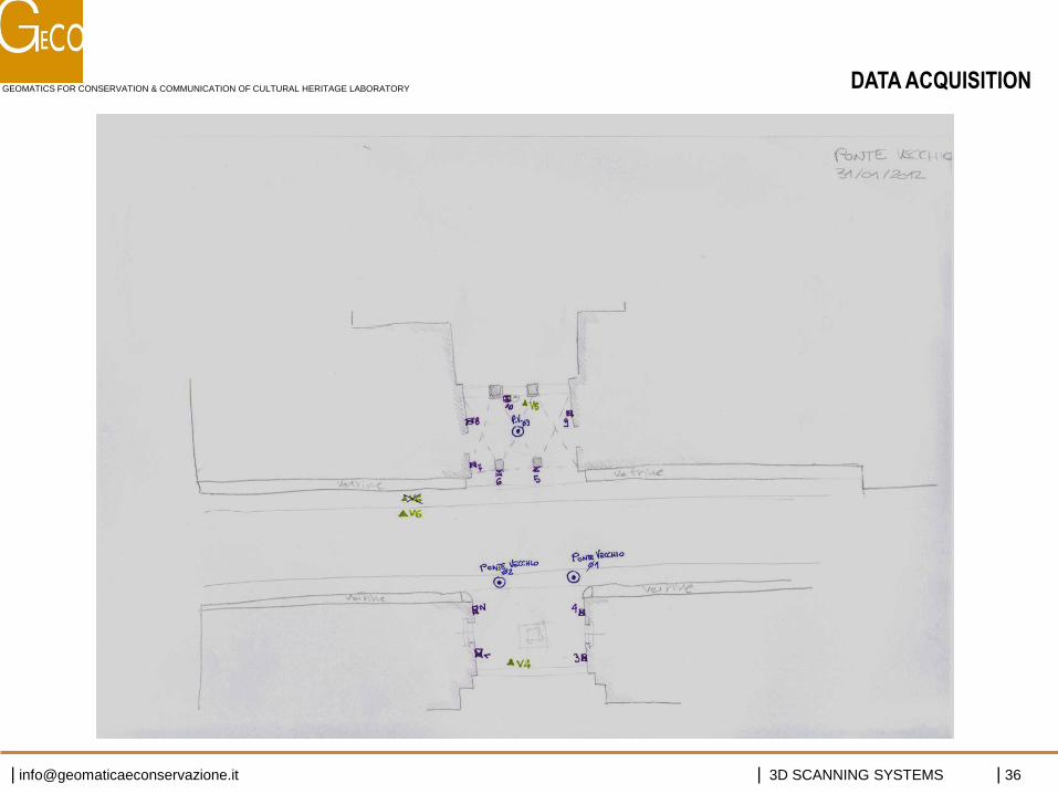
Sketches
-Outline of the area, rooms sketches, ...
- Scanner positions, target positions, model and name
DATA ACQUISITION
GEOMATICS FOR CONSERVATION & COMMUNICATION OF CULTURAL HERITAGE LABORATORY
| [email protected] | 3D SCANNING SYSTEMS | 36
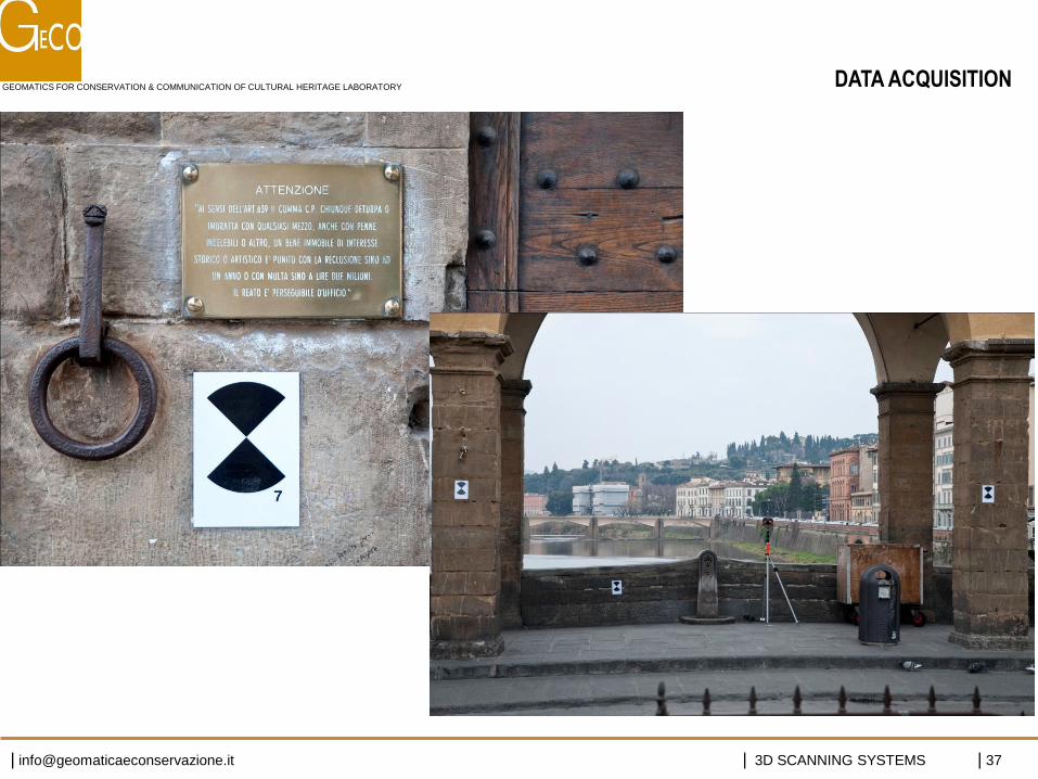
DATA ACQUISITION
GEOMATICS FOR CONSERVATION & COMMUNICATION OF CULTURAL HERITAGE LABORATORY
| [email protected] | 3D SCANNING SYSTEMS | 37
DATA ACQUISITION
GEOMATICS FOR CONSERVATION & COMMUNICATION OF CULTURAL HERITAGE LABORATORY
| [email protected] | 3D SCANNING SYSTEMS | 38
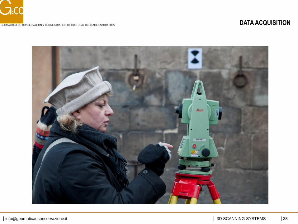
DATA ACQUISITION
GEOMATICS FOR CONSERVATION & COMMUNICATION OF CULTURAL HERITAGE LABORATORY
| [email protected] | 3D SCANNING SYSTEMS | 39
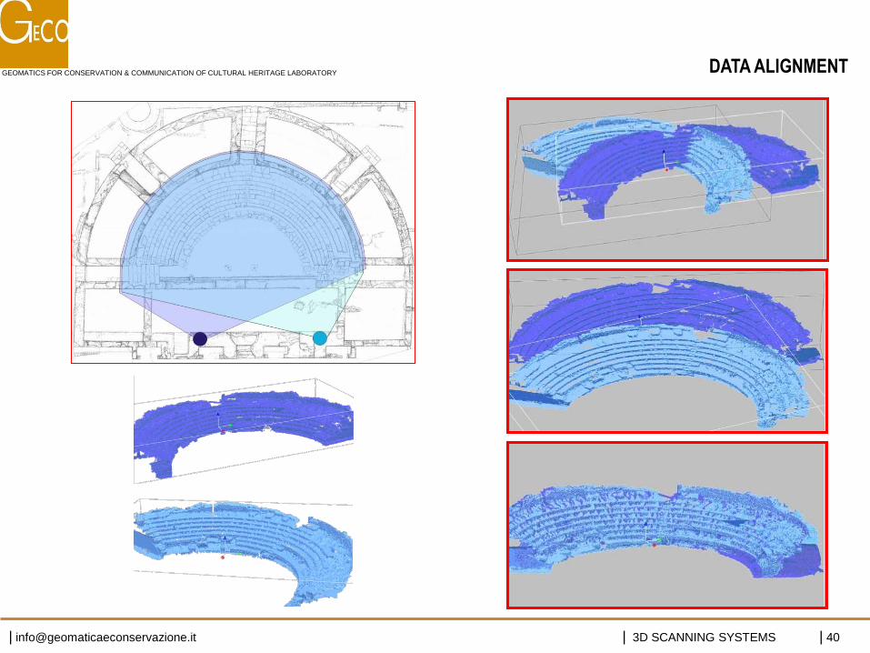
• Data acquired by different scans need to be aligned in the same reference system
• In architectural or landscape application it is useful to geo-reference data • Data can be aligned through homologous points or overlapped areas
DATA ALIGNMENT
GEOMATICS FOR CONSERVATION & COMMUNICATION OF CULTURAL HERITAGE LABORATORY
| [email protected] | 3D SCANNING SYSTEMS | 40
DATA ALIGNMENT
GEOMATICS FOR CONSERVATION & COMMUNICATION OF CULTURAL HERITAGE LABORATORY
| [email protected] | 3D SCANNING SYSTEMS | 41
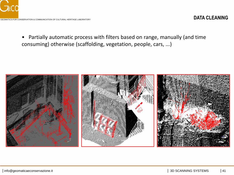
• Partially automatic process with filters based on range, manually (and time consuming) otherwise (scaffolding, vegetation, people, cars, ...)
DATA CLEANING
GEOMATICS FOR CONSERVATION & COMMUNICATION OF CULTURAL HERITAGE LABORATORY
| [email protected] | 3D SCANNING SYSTEMS | 42
• Model partitioning (for very big size projects):
• Outliers filtering
• Noise reduction: improves data quality by removing “speckle effect”
• Sampling data (random, grid, curvature sampling)
3D MODEL ELABORATION
GEOMATICS FOR CONSERVATION & COMMUNICATION OF CULTURAL HERITAGE LABORATORY
| [email protected] | 3D SCANNING SYSTEMS | 43
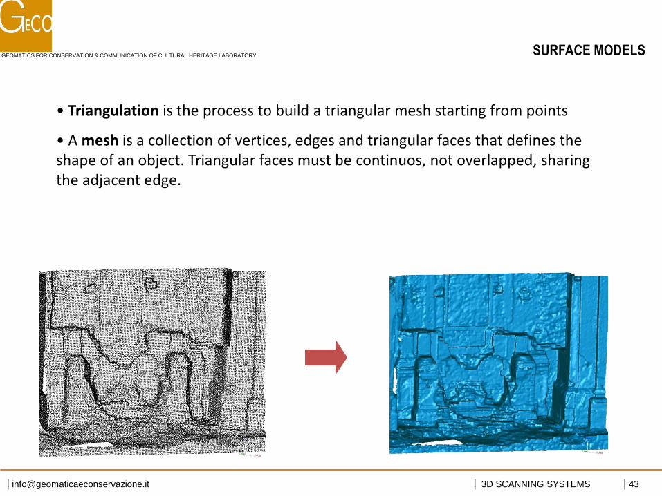
• Triangulation is the process to build a triangular mesh starting from points
• A mesh is a collection of vertices, edges and triangular faces that defines the shape of an object. Triangular faces must be continuos, not overlapped, sharing the adjacent edge.
SURFACE MODELS
GEOMATICS FOR CONSERVATION & COMMUNICATION OF CULTURAL HERITAGE LABORATORY
| [email protected] | 3D SCANNING SYSTEMS | 44
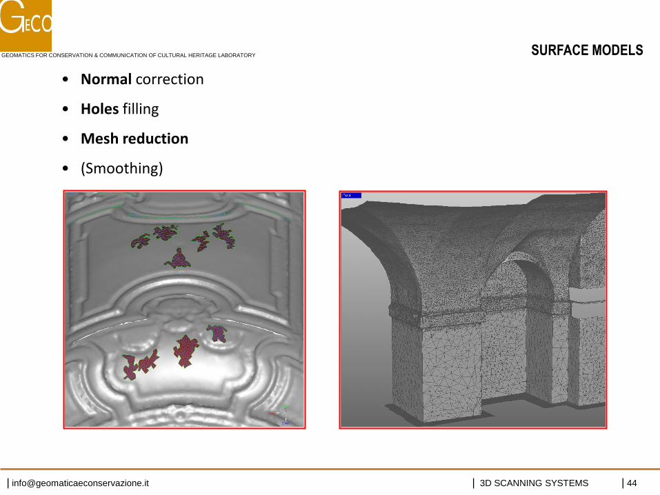
• Normal correction
• Holes filling
• Mesh reduction
• (Smoothing)
SURFACE MODELS