planning application 21/00794/ful report
TRANSCRIPT
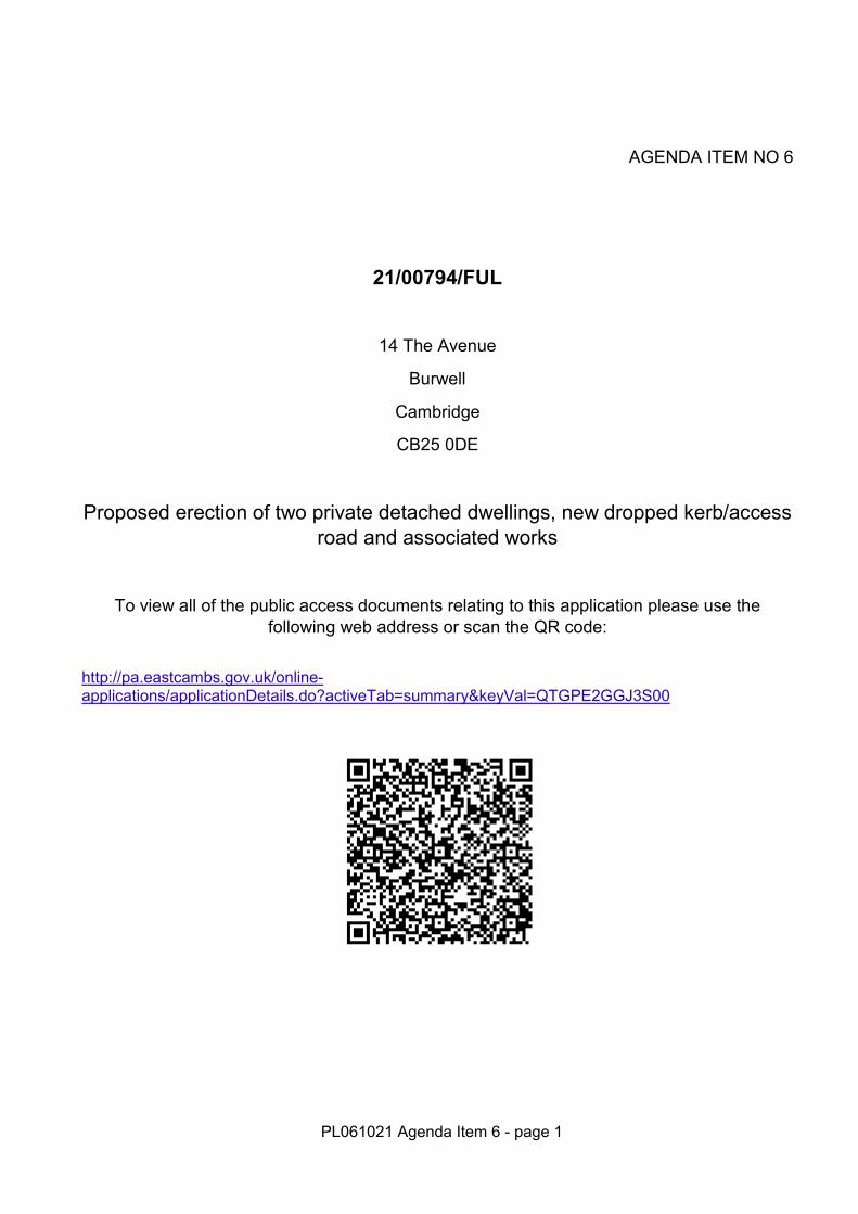
AGENDA ITEM NO 6
21/00794/FUL
14 The Avenue
Burwell
Cambridge
CB25 0DE
Proposed erection of two private detached dwellings, new dropped kerb/access road and associated works
To view all of the public access documents relating to this application please use the following web address or scan the QR code:
http://pa.eastcambs.gov.uk/online-applications/applicationDetails.do?activeTab=summary&keyVal=QTGPE2GGJ3S00
PL061021 Agenda Item 6 - page 1
PL061021 Agenda Item 6 - page 2
PL061021 Agenda Item 6 – page 3
AGENDA ITEM NO 6
1.0 RECOMMENDATION
1.1 Members are recommended to APPROVE the application subject to the
recommended conditions below: 1. Approved Plans 2. Time Limit – 2 years 3. Reporting of unexpected contamination 4. Foul water drainage details 5. Implementation of SUDs 6. Gates – restriction 7. New access – width 8. Parking, serving, turning areas 9. Visibility splays - plans 10. Access drainage 11. Details of proposed secure bike stores 12. Hard landscaping scheme 13. Soft landscaping scheme 14. Boundary treatments – details 15. Specified materials 16. Construction Environmental Management Plan 17. Construction times – standard times 18. Piling foundations 19. Tree protection measures
MAIN CASE
Reference No: 21/00794/FUL Proposal: Proposed erection of two private detached dwellings, new
dropped kerb/access road and associated works Site Address: 14 The Avenue Burwell Cambridge CB25 0DE Applicant: Mr Antony Smith Case Officer: Holly Chapman Planning Officer Parish: Burwell Ward: Burwell Ward Councillor/s: David Brown
Lavinia Edwards
Date Received: 21 May 2021 Expiry Date: 15th October 2021 Report Number [W80]
PL061021 Agenda Item 6 – page 4
20. Permitted Development removal – extensions/outbuildings 21. Permitted Development removal – gates, fences, walls 22. Biodiversity improvements 23. Sprinkler installation The conditions can be read in full on the attached Appendix 1
2.0 SUMMARY OF APPLICATION
2.1 The application submitted seeks planning permission for the construction of 2no.
two-bedroom detached bungalows. The bungalows are identical in footprint, with both plots mirroring one another. The measurements of the proposed bungalow are set out in the following table (Table 1):
Proposed Bungalow Metres Feet Ridge c.4.2 c.13.8 Eaves c.2.5 c.8.2 Width c.9.0 c.29.5 Depth c.11.6 c.38
Table 1 – Measurements of the Proposals
2.2 The dwellings are proposed to be constructed from Marley Modern Duo roof tiles in Anthracite, Wienerberger facing brick in Oakwood, and uPVC and composite windows and doors.
2.3 The rear portion of the application site where the proposed dwellings are to be located measures c0.077 hectares (c.770 square metres or c.0.2 acres) in size. This measurement excludes the access road and access channel from The Avenue and No.14 The Avenue and its rear garden area. This equates to a plot size of c.0.0385 hectares (c.385 square metres or c.0.1 acres).
2.4 Each of the proposed dwellings has a footprint of c.78 square metres (c.840 square foot), in addition to a small bike store area. In combination, the total of all structures proposed within the rear portion of the application site equates to c.156 square metres (c.1679 square foot). In percentage terms, this equates to a c.20% site coverage.
2.5 Plot 1 benefits from a total rear garden area of 105 square metres (1130sqft)
(excluding strips of land to the side of the dwelling). Excluding trees, this garden space would measure in excess of 50 square metres (c.539sqft). Plot 1 also benefits from a front garden of c.20 square metres (c.215sqft).
2.6 Plot 2 benefits from a total rear garden area of 176 square metres (c.1894sqft)
(excluding strips of land to the side of the dwelling). Excluding trees, this garden space would measure in excess of 50 square metres (c.539sqft). Plot 2 also benefits from a front garden of c.30 square metres (c.323sqft).
2.7 Plot 1 would lie between 6m to 10 metres (20 – 33 feet) (from the northern
boundary of the application site. Plot 2 would lie 10 metres (33 feet) from the
PL061021 Agenda Item 6 – page 5
northern boundary of the application site. Both Plot 1 and Plot 2 would lie c.1.8 metres (6 feet) from the shared boundaries with No.11 The Avenue (to the east) and No.15 The Avenue (to the west) respectively.
2.8 At the narrowest point, the proposed dwellings would be separated by c.6 metres
(20 feet), with Plot 1 sitting slightly forwards of Plot 2.
2.9 A new dropped kerb and access is proposed from The Avenue, providing a 5 metre by 10 metre (16 feet by 33 feet) passing point and a 3.05 metre (10 feet) width access road, widening to a shared turning area to the south of the proposed dwellings. The proposed dwellings would be served by two independently accessible parking spaces. A shared bin store is located to the south of the proposed dwellings along the rear boundary to No.14 The Avenue.
2.10 A rear garden space of 60 square metres (646sqft) is provided to No.14 The
Avenue, along with a bin store to the front of the application site along its eastern boundary. The existing private right of way for No.15 The Avenue is illustrated on the plans as passing through the rear garden to No.14 The Avenue. No.14 The Avenue does not currently benefit from any on-plot parking, and the current parking arrangements for the dwelling would remain, this being the use of the roundabout within the centre of The Avenue. A degree of on-plot parking would also be provided for the host dwelling of No.14 The Avenue.
2.11 The application has been called to Planning Committee by Councillor Brown on the
basis that the proposals would be detrimental to highway safety given the number of dwellings proposed.
2.12 The full planning application, plans and documents submitted by the Applicant can be viewed online via East Cambridgeshire District Council’s Public Access online service, via the following link http://pa.eastcambs.gov.uk/online-applications/.
3.0 PLANNING HISTORY 3.1 There is no planning history of relevance relating to the application site. As it has
been uploaded as a public document, the LPA can confirm that the Applicant entered into pre-application advice with the LPA concerning the potential re-development of the application site in 2020. This response is available to view on the Council’s website.
3.2 Nearby planning history of relevance is set out below:
No.17a The Avenue previously land between No.17 and No.18 The Avenue
15/00867/FUL Proposed erection of a private detached dwelling and associated works
Approved 16.09.2015
16/00338/FUL Amendment to approved chalet bungalow planning application 15/00867/FUL
Approved 06.06.2016
PL061021 Agenda Item 6 – page 6
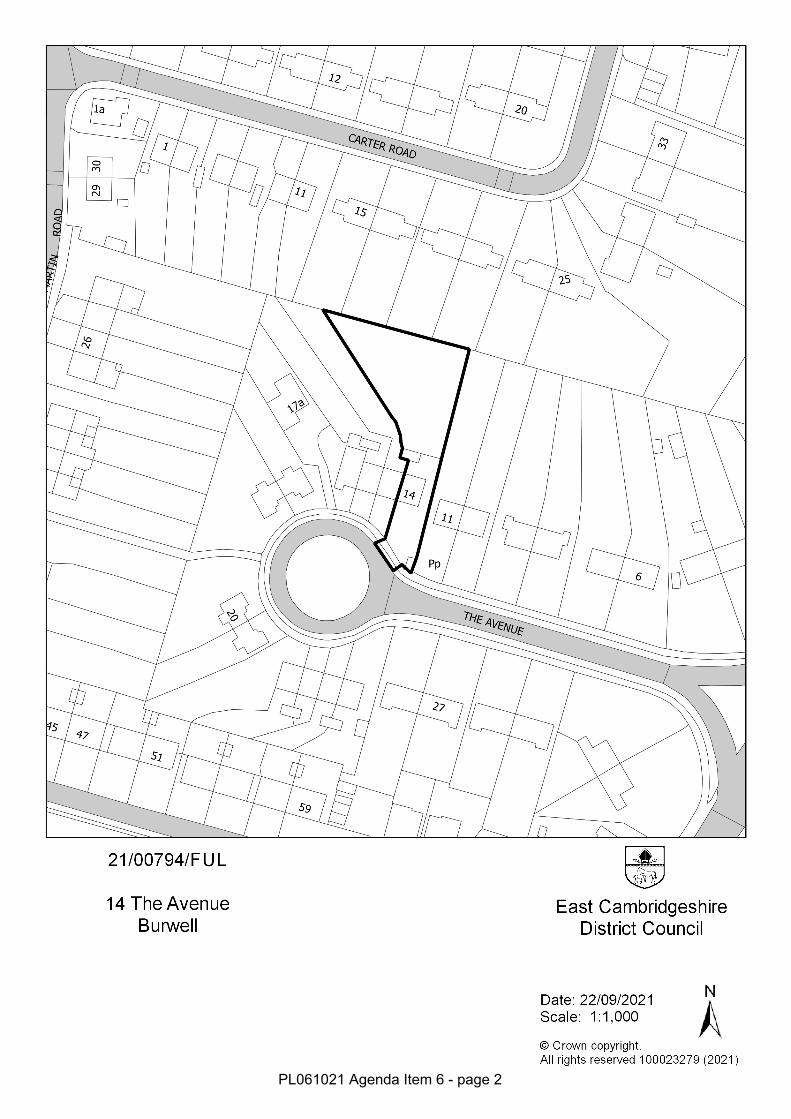
4.0 THE SITE AND ITS ENVIRONMENT 4.1 The application site comprises in total a 0.1-hectare (1,000 square metres / 0.25
acres) parcel of garden land associated with No.14 The Avenue, Burwell. No.14 The Avenue comprises a two-storey end-of-terrace dwelling, in a row of four other similar properties, along the northern side of The Avenue. The application site lies wholly within the policy-defined development envelope for Burwell.
4.2 The gardens to No.15 and No.16 The Avenue are long and set diagonally to the dwellings to which they relate. No. 17 The Avenue benefitted from a much wider garden until it was sub-divided to facilitate the erection of No.17a The Avenue. No.17 therefore benefits from a smaller garden to the side and rear of the dwelling.
4.3 As the application site comprises former garden land, the site is largely laid to
grass, with areas of paving slabs and hard standing. A row of trees lies along the northern boundary to the application site and extends along the rear of properties along The Avenue. A recently designated TPO tree (E/02/21 – Honey Locust) lies outside of the application site within the curtilage of No.15 The Avenue to the west.
4.4 Within The Avenue the scale of development is characterised by two-storey
terraced or semi-detached dwellings and a number of semi-detached bungalows with prominent front gables. The chalet-bungalow of 17a also sits to the rear of No.17 and 18 The Avenue. Pebbledash, render and darker coloured bricks are characteristic of the materials palette found within the Avenue.
25 Carter Road
18/00352/OUT Proposed private detached bungalow with existing access retained.
Approved 22.05.2018
19/00235/OUT Proposed private detached bungalow with existing access retained
Approved 10.04.2019
21/00793/RMA Reserved matters for Appearance, Landscaping and Scale for previously approved 19/00235/OUT for Proposed private detached bungalow with existing access retained
Approved 03.09.2021
27 Carter Road
21/00431/FUL Proposed 2No. dwellings
Pending Consideration
N/A

PL061021 Agenda Item 6 – page 7
4.5 To the front (south) of No. 14 The Avenue lies a water pump, set within a concrete slab. This pump is not a listed structure nor is it designated as a feature of special interest.
4.6 The application site is not located within a Conservation Area, and does not lie
nearby any Listed Building, Structures or Monuments. The application site lies wholly within Flood Zone 1 (lowest risk) and lies within a Green Risk Zone for Great Crested Newts (lowest risk).
5.0 RESPONSES FROM CONSULTEES 5.1 Responses were received from the following consultees and these are summarised
below. The full responses are available on the Council's web site. Environmental Health - 2 June 2021
States: “Peter will respond separately with his comments concerning the Contaminated Land Study. Due to the proposed number of dwellings and the close proximity of existing properties I would advise that construction times and deliveries during the construction phase are restricted to the following: 07:30 - 18:00 each day Monday - Friday 07:30 - 13:00 on Saturdays and None on Sundays or Bank Holidays If it is necessary to undertake ground piling I would request that a method statement be produced and agreed in writing with the Local Planning Authority (LPA) before work takes place. If there is no intention to utilise ground piling then I would request this be confirmed in writing and a condition which prevents it be attached until such time as a ground piling method statement is agreed with the LPA. No other comments to make at this time but please send out the environmental notes.”
Environmental Health - 16 June 2021 States: “I have read the Envirosearch report dated 24th November 2020 and accept the findings. I recommend that a condition requiring site investigation, etc. is not required. I recommend that standard contaminated land condition 4 (unexpected contamination) is attached to any grant of permission due to the proposed sensitive end use (residential).” Environmental Health - 16 August 2021 States: “I have nothing to add to my previous comments below.”
Environmental Health - 8 September 2021 States: “I have nothing to add to my previous comments.”
PL061021 Agenda Item 6 – page 8
Ward Councillor David Brown – 22 June 2021 The application has been called to Planning Committee on the basis that the proposals would be detrimental to highway safety given the number of dwellings proposed.
Local Highways Authority - 18 June 2021 States: “Subject to the following comments and recommendations: The pedestrian visibility splays shown at the proposed access should be 2m x 2m in both directions, not 1.5m. The width of the vehicular crossover access should be curtailed to the area which falls between the pedestrian visibility splays only. I request that the applicant provide a revised plan with dimensions of the access and turning area shown. In particular, I need to see the clear space available alongside number 14 as Part B5 of the Building Regulations specifies a minimum access width of a 3.7m. The access needs to incorporate appropriate measures to prevent surface water drainage from entering the public highway along The Avenue. It is unclear what surface material is proposed for the access, but no unbound material will be permitted within 5m of the footway edge. Once the above comments have been addressed, I will be able to recommend appropriate conditions.”
Local Highways Authority - 16 August 2021
States: “Subject to the following comments and recommendations: The revised site layout addressed my previous comments and I therefore have no objections. However, as the space available to access the proposed properties is only 3.05m, which is below the requirements as set out in Part B5 of the Building Regulations 2010, I recommend that you consult with the Fire & Rescue service in relation to fire safety and access.” In their full response, the LHA recommended conditions relating to: - Restriction of gates across the proposed vehicular access; - Minimum width and length of the access provided; - Provision of parking and turning area prior to occupation; - Provision of pedestrian visibility splays at the junction of the proposed access
road with The Avenue; - Drainage of all hard standing and access.
Local Highways Authority – 06 September 2021 In response to amended layout plan Ref. P-6222-06 Rev B, the LHA states: “Broadly I don’t consider this layout to be that different to the layout previously submitted. The only comment I would make is to curtail the front garden roughly at the same location of the previous parking spaces to aid the reversing and turning movement out of parking bay 1. Otherwise this is acceptable. “
PL061021 Agenda Item 6 – page 9
In their full response, the LHA included an illustration to depict the removal of the rounded edge to the larger of the two front gardens provided for Plot 2. The applicant has reflected this in their amended plans.
Waste Strategy (ECDC) - 21 June 2021 • East Cambs District Council will not enter private property to collect waste or
recycling, therefore it would be the responsibility of the owners/residents to take any sacks/bins to the public highway boundary on the relevant collection day and this should be made clear to any prospective purchasers in advance, this is especially the case where bins would need to be moved over long distances; the RECAP Waste Management Design Guide defines the maximum distance a resident should have to take a wheeled bin to the collection point as 30 metres (assuming a level smooth surface).
• Under Section 46 of The Environmental Protection Act 1990, East Cambridgeshire District Council as a Waste Collection Authority is permitted to make a charge for the provision of waste collection receptacles, this power being re-enforced in the Local Government Acts of 1972, 2000, and 2003, as well as the Localism Act of 2011.
• Each new property requires two bins; this contribution is currently set at £52 per property.
• Payment must be made in advance of bins being delivered; East Cambs District Council Account Number 43135897, Sort Code 52-41-19, reference should be the planning application number followed by (bins) i.e. 15/012345/FUL (bins) a separate e-mail should also be sent to [email protected] detailing the payment amount and the planning reference number.
ECDC Trees Team - 19 July 2021 States: “Please can a copy of the Arboricultural Impact Assessment (AIA) that the tree protection plan is based on be supplied as it will contain invaluable information allowing suitable assessment of the site to be made such as the tree dimensions, the quality assessment, tree condition, shade analysis, any recommended works and details relating to the protection of the retained trees (fencing and any temporary surfacing). Please also note that the tree marked in the garden of 15 The Avenue is covered by Tree Preservation Order (TPO) E/02/21 which was confirmed 01/07/2021.”
ECDC Trees Team - 16 August 2021 States: “I'm concerned that the proposed new parking area for plot 2 will result in excess of the recommended 20% maximum coverage of the tree T25's Root Protection Area (RPA), BS 5837:2012 Trees in relation to design, demolition and construction recommendations states on page 25 section 7.4.2.3 that new permanent hard surfacing should not exceed 20% of any existing unsurfaced ground within the RPA. No spercific information relating to the % amount of the RPA to be covered by the permanent hard surfacing has been supplied it is only indicated on the tree protection plan and looks closer to 30% coverage. It also appears that tree T25 will create shade on the front elevation of plot 2 particularly the only window of bedroom 3. A shade analysis should normally be displayed on the tree report plan and look similar to the below image.
PL061021 Agenda Item 6 – page 10
Please can information relating to the RPA coverage and shade analysis be provided prior to determination of the application.” ECDC Trees Team – 21 September 2021 States: “The revised layout will be acceptable on tree grounds but we will need to condition submission of updated tree protection preferably in the form of an Arboricultural Method Statement and tree protection plan(s) (TPP) such as below.” In their full response, the Tree Officer recommends the LPA’s standard condition relating to the provision of tree protection details prior to the commencement of development. Parish - 16 June 2021 Burwell Parish Council objects to this application. Over development of the site and concerns over access. Parish - 11 August 2021 States: “Burwell Parish Council Objects to these amendments and the additional information provided. The amendments and additional information do not resolve the objections previously raised by the Parish Council. We have a number of neighbours who have raised concerns with this proposal and the Parish Council fully supports the issues raised. “
Building Control - East Cambridgeshire District Council - 24 June 2021 States: “Further to our earlier discussion re the above I confirm that the proposed access arrangements for Fire Appliances, although strictly not in accordance with the recommendations in Approved Document B5, will be accepted as satisfactory and not raised as a contravention at plan check stage.”
Building Control - East Cambridgeshire District Council - 8 September 2021 States: “We have no adverse comments.”
Cambridgeshire Fire And Rescue Service - No Comments Received CCC Growth & Development - No Comments Received
5.2 A site notice was displayed near the site on 11th June 2021. 5.3 Neighbours – a total of ten neighbouring properties were notified and the responses
received are summarised below. A total of seven neighbour objections have been received (where multiple responses from the same property have been counted as a single response) and one letter in support. Full copies of all responses are available to view on the Council’s website. Residential Amenity
• Loss of privacy; • 10 metre rear boundary and 50 square metre gardens not likely to be
provided; • Over-looking;
PL061021 Agenda Item 6 – page 11
• Loss of light; • Overshadowing; • Disturbance from additional vehicles and unbound surface; • Pollution from exhaust fumes; • Construction impacts upon noise, disturbance and health; • Affects public views • Overshadowing of vegetable patch reducing ability for growth; • Dwellings could be enlarged under PD rights • Rear garden to No.14 The Avenue is smaller than No.17a; • Proximity to No.11 The Avenue, its front door and shared boundary; • Front door to No.11 The Avenue close to boundary fence;
Character and Appearance
• Over development; • Effect on the character and appearance of the area; • Dwellings could be enlarged under PD rights; • Effect on Conservation Area;
Highways, Access and Parking
• Highway safety • Parking provision not provided for No.14 The Avenue; • Access not wide enough for emergency vehicles; • Pedestrian safety concerns over vehicles travelling from the rear of the site
onto The Avenue and the residents of No.15 who benefit from a right of way down the proposed access road;
• Access for disabled persons; • Level/smooth access for bins; • Front door of No.14 The Avenue close to access road; • Access road would not be lit; • Pedestrian, cyclist and vulnerable user safety; • Access road would need to navigate around the historic water pump; • Children playing on the roundabout and concerns over safety of increased
vehicles; • Affects a Right of Access
Tree and Biodiversity Impacts
• Biodiversity impacts; • Proposed hedgehog holes to be installed in fences the Applicant does not
own; • Loss of trees; • Loss of undocumented trees; • Impact on trees • TPO tree impacts and protection;
Drainage, Flooding and Climate Change
• Drainage impacts; • Climate change and sustainability measures;
PL061021 Agenda Item 6 – page 12
Other Matters • No.17a The Avenue is not a good comparator for the proposed scheme; • Lack of clarity over the scale of the proposals; • Boundary line and placement of historic water pump are not accurate; • Accuracy of plans; • Concerns over description of development and clarity of this; • Not enough site notices
Comments in Support of the Proposals
• All trees are to be retained; • Bungalows would not cause any overlooking; • The proposed build would enhance the area; • Proposals would provide more opportunities for people to live in the village
6.0 The Planning Policy Context 6.1 East Cambridgeshire Local Plan 2015
GROWTH 2 Locational strategy GROWTH 3 Infrastructure requirements GROWTH 5 Presumption in favour of sustainable development ENV 1 Landscape and settlement character ENV 2 Design ENV 4 Energy efficiency and renewable energy in construction ENV 7 Biodiversity and geology ENV 8 Flood risk ENV 9 Pollution HOU 2 Housing density COM 7 Transport impact COM 8 Parking provision Supplementary Planning Documents Developer Contributions and Planning Obligations Design Guide Contaminated Land - Guidance on submitted Planning Application on land that may be contaminated Flood and Water Natural Environments Climate Change National Planning Policy Framework 2021 2 Achieving sustainable development 4 Decision-making 5 Delivering a sufficient supply of homes 9 Promoting sustainable transport 11 Making effective use of land 12 Achieving well-designed places 14 Meeting the challenge of climate change, flooding and coastal change
PL061021 Agenda Item 6 – page 13
15 Conserving and enhancing the natural environment Technical Guidance to the National Planning Policy Framework Technical housing standards – nationally described space standard
7.0 PLANNING COMMENTS 7.1 The main issues to consider in the determination of this application are; the principle
of development; the impact it may have on the residential amenity of nearby occupiers; the impact it may have on the character and appearance of the area; and the impact it may have on parking and highway safety; as well biodiversity, trees and ecology; flood risk and drainage; climate change; and contamination.
7.2 Principle of Development 7.3 The application site lies wholly within the development envelope for Burwell, where
Policy GROWTH 2 of the ECDC Local Plan 2015 seeks to permit development within the policy-defined development envelope, provided there is no significant adverse effect on the character and appearance of the area and that all other material planning considerations and relevant Local Plan policies are satisfied. Section 5 and 11 of the National Planning Policy Framework (NPPF) seeks to promote the delivery of a sufficient supply of homes and secure the efficient use of land within settlements.
7.4 As set out within the Design Guide SPD, back-land development as proposed will
only be considered to be acceptable if the following criterion are met: • Back land development (one dwelling built behind another) will only be
acceptable if supported by a contextual analysis of the locality (particularly with reference to the point below about large houses);
• There must be sufficient space to allow for an access road to the rear, the width of which may be determined by the status of any adjoining highway;
• Adequate protection against noise and disturbance must be provided for
the host dwelling;
• Consideration should be given to the inclusion of adjacent land, to avoid piecemeal development. Applications may be refused if it cannot be demonstrated that the possibility of a more comprehensive development has not been explored;
• The fact that there may be space within the curtilage to construct a
dwelling, will not, in itself, be sufficient justification for doing so;
• There can be no presumption that large houses in extensive curtilages should be able to subdivide the garden ground into smaller plots.
PL061021 Agenda Item 6 – page 14
7.5 With the submission, the Applicant has provided a contextual analysis of The Avenue and surrounding area. The most notable back-land dwelling within The Avenue is that of No. 17a The Avenue (permitted under LPA Ref. 15/00867/FUL). The planning history section also sets out a number of other permitted (and one pending) application for traditionally back-land proposals within close proximity to the application site. In light of the above, it would be unreasonable for the LPA to object to the principle of the proposed development on the basis that it comprises back-land development in this instance.
7.6 The compliance of the proposals with the other criterion as stipulated within the Design Guide SPD will be discussed elsewhere within this report.
7.7 The proposed dwellings would be liable to the Community Infrastructure Levy (CIL),
and this payment would be in line with Policy GROWTH 3 and the Developer Contributions SPD.
7.8 Policy GROWTH 5 of the ECDC Local Plan 2015 also states that the District
Council will work proactively with applicants to find solutions which mean that proposals can be approved wherever possible, and to secure development that improves the economic, social and environmental conditions in the area.
7.9 On the above basis, the principle of the proposed development is considered to be
acceptable in accordance with Policies GROWTH 2, GROWTH 3 and GROWTH 5 of the ECDC Local Plan 2015, the Design Guide SPD, the Developer Contributions SPD and the guidance contained within the National Planning Policy Framework.
7.10 Residential Amenity
7.11 Policy ENV 2 of the East Cambridgeshire Local Plan 2015 requires proposals to
ensure that there are no significantly detrimental effects on the residential amenity of nearby occupiers. Paragraph 130 of the NPPF requires proposals to ensure that they create safe, inclusive and accessible development which promotes health and wellbeing and provides a high standard of amenity for existing and future users.
7.12 The Design Guide SPD requires that, in most cases, rear private amenity space
should be a minimum of 50 square metres (538sqft). Where rear inter-visible windows would be likely, the SPD also requires that dwellings be sited 10 metres (33 feet) from the rear boundary, to achieve a sufficient separation distance between properties.
7.13 The proposed single-storey dwellings would be modest in their scale and footprint,
and would be set off of the shared boundaries with No.15 and No.11 The Avenue. As a result of their scale and location, the proposals are not considered to result in overshadowing, overbearing or loss of light to No.15 or No.11 The Avenue, or the host dwelling of No.14.
7.14 Concern has been raised by No.15 The Avenue over loss of light to the existing
vegetable patch within the garden. Any potential shading caused by the proposed development upon the garden of No.15 or No.11 The Avenue is not considered to be so significant so as to warrant a refusal on this basis.
PL061021 Agenda Item 6 – page 15
7.15 The Trees Officer raised in their response dated the 16th August 2021 the possibility of shading caused by the TPO tree (deciduous – honey locust) within the rear garden of No.15 The Avenue upon the proposed Plot 2. It is likely that the tree would cause a degree of shading to the front bedroom of Plot 2, more notably in the evening. However, this degree of shading is not considered to be so significant to warrant a refusal on this basis, nor is it considered to place undue pressure on the TPO tree in terms of pruning.
7.16 As a result of their scale, the proposed dwellings would not contain any habitable
room windows at first floor level which would result in the overlooking of neighbouring dwellings within The Avenue or Carter Road to the north. Whilst proposed Plot 1 is sited within 10 metres (33 feet) of the rear site boundary, given its scale it would not result in inter-visible windows with properties along Carter Road, and would not therefore be contrary to the Design Guide SPD. A condition is also recommended to be imposed to prevent the enlargement of the proposed dwellings under Permitted Development rights without the prior written consent of the LPA to prevent insensitive development which may give rise to overlooking or overbearing impacts upon neighbouring properties.
7.17 The proposed dwellings would be located a sufficient distance (20 metres / 66 feet)
from No.14 The Avenue to prevent inter-visible windows between the rear elevation of No.14 The Avenue and the proposed dwellings, as stipulated within the Design Guide SPD.
7.18 Photos submitted by neighbouring properties show that views are possible from the
upper floor windows of these dwellings onto the application site. A degree of overlooking is accepted in established residential areas, although it is relevant that these views onto the application site would be focused towards the front gardens and parking areas of the proposed dwellings. The proposed dwellings themselves would provide screening to the proposed rear private gardens from views onto the site.
7.19 With regard to the size of gardens provided for the prospective dwellings
(105sqm/1130sqft for Plot 1 and 176sqm/1894sqm for Plot 2), the rear gardens provided exceed the minimum expected standard of 50 square metres (538sqft). With trees included, the gardens measure significantly over this standard. The proposed garden retained for No.14 The Avenue (60sqm/646sqft) is also comparable in size to that of No.17 The Avenue, and exceeds the 50 square metre (538sqft) minimum. Permitted Development rights for outbuildings and extensions to the dwellings will be restricted via a condition to ensure that sufficient garden space is retained for the proposed dwellings.
7.20 Neighbour comments have also raised concern with regard to the noise and
disturbance associated with vehicle movements in between No.14 and No.11 The Avenue, and to the rear of the properties. Concerns have also been raised regarding additional disturbance caused by new residential uses.
7.21 The proposed residential uses are considered to be compatible with the residential
uses within the area. Whilst the proposals would result in additional inhabitants and noise associated with these uses, the introduction of the residential use is not considered to be harmful in itself.
PL061021 Agenda Item 6 – page 16
7.22 No.11 The Avenue contains its front door facing onto the side elevation of No.14 The Avenue. The shared boundary between No.14 and No.11 has historically been characterised by dense hedge planting and close-boarded fence. The proposals seek to erect a 1.8 metre (6 foot) close board fence on the boundary of the application site, although specific boundary details will be secured via planning condition. It is considered that the introduction of this fencing, which would be considered permitted development in this location set back from the highway channel, would not result in any greater residential amenity impacts than the existing fencing and hedge arrangement to the side of No.11 The Avenue. The proposed fence is shown to be 2 metres (6.6 feet) from the side elevation of No.11, which would allow sufficient access to the front door of the property.
7.23 No.14 The Avenue contains a ground floor window within its side elevation which
serves a non-habitable room (cupboard). The dwelling has its principal ground and first floor outlooks to the rear. In light of the above, as well as the separation distance of the access from No.11 The Avenue and the fencing between the proposed access way and No.11 The Avenue, it is considered that the proposed additional vehicle movements would not result in unacceptable noise or disturbance upon the two dwellings.
7.24 The use of gravel to the rear of the application site, whilst not shown on the plans, is
illustrated within the submitted CGI imaging. It is considered that gravel driveways can give rise to detrimental noise and disturbance and for this reason a condition could be imposed to prevent the use of unbound surfacing within the site for the parking and turning of vehicles, in the interests of residential amenity.
7.25 Concern has also been raised by residents over the construction of the proposed
dwellings. The Environmental Health Officer has recommended the LPA’s standard conditions for construction hours and a condition concerning the piling of foundations. Given the width of the access, it is considered that the delivery of construction vehicles and materials to the site may be more prone to parking within the adopted highway. For this reason, it is considered reasonable to require the applicant to submit a Construction Environmental Management Plan prior to commencement of development to manage the construction process and the impacts upon surrounding residents. This would also give the LPA more control in ensuring construction activities take place in accordance with a number of agreed parameters.
7.26 For the reasons provided, it is therefore considered that the proposals accord with
Policy ENV2 of the Local Plan 2015, the Design Guide SPD and the guidance contained within the NPPF in respect of residential amenity on the basis of their location, scale and design.
7.27 Character and Appearance
7.28 Policy ENV2 of the East Cambridgeshire Local Plan 2015 requires that all
development proposals are designed to a high quality, enhancing and complementing local distinctiveness and public amenity by relating well to existing features and introducing appropriate new designs. Additionally, Policy ENV2 of the East Cambridgeshire Local Plan 2015 makes it clear that all new development
PL061021 Agenda Item 6 – page 17
proposals will be expected to respect the density and character of the surrounding area, whilst ensuring that the location, layout, scale, form, massing, materials and colour of buildings relate sympathetically to the surrounding area and each other, as well as creating quality new schemes in their own right.
7.29 Policy HOU 2 of the ECDC Local Plan 2015 requires that proposals take into
account the existing character of the locality and densities of existing development, as well as the need to make efficient use of land; the biodiversity of the site and its surroundings; the need to accommodate other uses such as open space and parking, the levels of accessibility; and the safeguarding and provision of high levels of residential amenity.
7.30 The East Cambridgeshire Design Guide Supplementary Planning Document 2012
states that, in most cases, building plots should be approximately 300 square metres (3229sqft), the footprint of any proposed development should be no more than approximately one third of the plot size and rear private amenity space should be 50sqm (538sqft).
7.31 The recent updates to the National Planning Policy Framework (July 2021) have
also resulted in a higher bar being set for design, whereby all development should seek to achieve beautiful, high-quality, well-designed and sustainable buildings.
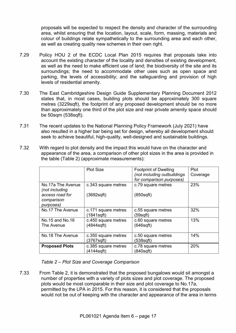
7.32 With regard to plot density and the impact this would have on the character and
appearance of the area, a comparison of other plot sizes in the area is provided in the table (Table 2) (approximate measurements):
Plot Size Footprint of Dwelling
(not including outbuildings for comparison purposes)
Plot Coverage
No.17a The Avenue (not including access road for comparison purposes)
c.343 square metres (3692sqft)
c.79 square metres (850sqft)
23%
No.17 The Avenue c.171 square metres (1841sqft)
c.55 square metres (59sqft)
32%
No.15 and No.16 The Avenue
c.450 square metres (4844sqft)
c.60 square metres (646sqft)
13%
No.18 The Avenue c.350 square metres (3767sqft)
c.50 square metres (538sqft)
14%
Proposed Plots c.385 square metres (4144sqft)
c.78 square metres (840sqft)
20%
Table 2 – Plot Size and Coverage Comparison
7.33 From Table 2, it is demonstrated that the proposed bungalows would sit amongst a number of properties with a variety of plots sizes and plot coverage. The proposed plots would be most comparable in their size and plot coverage to No.17a, permitted by the LPA in 2015. For this reason, it is considered that the proposals would not be out of keeping with the character and appearance of the area in terms
PL061021 Agenda Item 6 – page 18
of their plot density and coverage, and would satisfy the guidance as stipulated within the Design Guide SPD and are of a suitable density.
7.34 With regard to visibility of the proposals, given their siting to the rear of No.14 The Avenue, the proposals would not be prominent within the street-scene of The Avenue. Plot 1 would be most visible given its siting at the terminus of the proposed access way serving the application site. It is considered that Plot 2 would be screened from view within the street-scene given the existing intervening development along The Avenue.
7.35 Whilst Plot 1 would be visible within the street-scene, the scale and design of both
dwellings is considered to be sympathetic and complementary to the existing development of The Avenue. The gable frontages to the bungalows and their scale are considered to be comparable to the existing properties within the street-scene, and the materials palette is considered to reflect materials found elsewhere within the street-scene. Whilst illustrative, the CGI images submitted demonstrate that the proposed materials palette would work well to create a cohesive and high quality scheme.
7.36 Details of the enclosed cycle store would be secured via a condition, as these
details have not been submitted with the application.
7.37 For the above reasons, the introduction of the proposed dwellings is not considered to result in visual harm to the character or appearance of the area, and would provide a complementary development within The Avenue. The proposals are therefore considered to comply with Policies ENV 1, ENV 2 and HOU 2 of the ECDC Local Plan 2015, the Design Guide SPD and the NPPF.
7.38 Highways, Parking and Access
7.39 Policy COM 8 of the ECDC Local Plan 2015 seeks to ensure that proposals provide
adequate levels of parking (two spaces for a dwelling in this location), and Policy COM 7 of the ECDC Local Plan 2015 requires proposals to provide safe and convenient access to the highway network. Section 9 of the NPPF seeks to secure sustainable transport.
7.40 The application proposals provide sufficient parking and turning space for the
proposed dwellings within the rear portion of the application site. Following amendments, the Local Highways Authority have raised no objection to the parking arrangements for the proposed dwellings.
7.41 It is also relevant that No.14 The Avenue does not currently benefit from off-street
parking, or a dropped kerb to provide vehicular access to the application site. Parking for the property is provided on the roundabout within the middle of The Avenue. Whilst this is accepted to be an unusual parking arrangement, aerial and street-level imaging demonstrate that it has been utilised as parking for the properties of The Avenue for over a decade for this purpose. It would therefore be unreasonable for the LPA to object to the continued use of the roundabout as parking for No.14 on this basis, but it is also relevant that the proposals would provide opportunity for the host dwelling to benefit from a degree of off-street parking.
PL061021 Agenda Item 6 – page 19
7.42 The proposed dwellings would be served via a 3.05 metre wide (10 feet) access road from The Avenue. A wider 5m x 10m (16 feet x 33 feet) passing bay is provided to the south of No.14 The Avenue at the junction of the proposed access with The Avenue, and to the north beyond No.14 The Avenue the access road widens to 3.7 metres (12 foot) in width.
7.43 Concern has been raised by local residents and the Ward Councillor with regard to
the suitability of the proposed access road and the highway safety implications of this access and the number of dwellings it is proposed to serve.
7.44 It should be noted that the LHA raise no objection to the proposed access, its width or its alignment. The original recommendation for the 3.7 metre (12 foot) access width by the LHA was made on the basis that this would provide sufficient width for fire service vehicles to pass along the access road, in accordance with Part B5 of Building Regulations (pertaining to access and services for fire services). Whilst the proposed access falls below this width, comments from Building Control have confirmed that no objection would be raised on the basis of the access width and fire safety should a Building Control application be received for the proposed dwellings. Cambridgeshire Fire and Rescue have been consulted three times on the proposal, but have not provided comment.
7.45 The applicant has expressed willingness to provide sprinkler systems within the
dwellings to abate any fire related safety concerns, as a safeguarding measure, it is considered necessary to impose this condition.
7.46 With regard to the existing right of way of No.15 The Avenue over the rear garden to
No.14 and along the proposed access road, concerns have been raised that this would increase pedestrian and vehicle conflict. Occupiers of No.15 The Avenue and the prospective dwellings would be required to walk down the proposed access road in order to access The Avenue and place their bins at the kerbside on collection day. In discussion with the LHA, this is not an uncommon arrangement found within residential development, and given the width of the access way proposed, vehicles are likely to be discouraged from travelling at higher speeds.
7.47 The LHA have not raised any pedestrian safety concerns as a result of the
proposals in their formal comments, and this has been clarified in discussion with the LHA on this particular matter. The Applicant is willing to provide mirrors along the access road to allay concerns over pedestrian visibility, but without any technical advice to suggest that this is necessary, it is not considered reasonable to impose this requirement upon the Applicant.
7.48 Concerns have also been raised regarding the increased vehicular traffic onto The
Avenue, and the risks this may pose to children who use the roundabout for recreation. It should be noted that all properties within The Avenue, including the proposed dwellings, benefit from ample rear and private amenity space. The roundabout within The Avenue is not a designated area of open space, and forms part of the public highway. The use of this space for recreation is not therefore considered to be material to the planning proposals.
7.49 With regard to pedestrians using The Avenue, the proposals provide sufficient
visibility splays as required by the LHA to ensure pedestrian safety.
PL061021 Agenda Item 6 – page 20
7.50 With regard to providing level access to No.15 The Avenue, the right of access is in this instance a civil and legal matter rather than one that can be controlled by the planning system. Notwithstanding, the proposals would make an improvement on the existing right of way over the application site, providing a level and bound surface and dropped kerb onto The Avenue for use by disabled persons.
7.51 Concern has also been raised regarding the proximity of the front door to No.14 The
Avenue to the access road proposed. It is relevant that the surfacing materials of these areas are likely to be different, although specific hard surfacing materials will be secured via a condition. These materials will differentiate between access road and pedestrian areas. The LHA have raised no objection to the proposals on this basis.
7.52 For the above reasons, the proposals are not considered to result in any adverse
highway safety concerns, and the proposals are therefore considered to be compliant with Policies COM 7 and COM 8 of the ECDC Local Plan 2015 and the NPPF.
7.53 Ecology, Trees and Biodiversity
7.54 Policy ENV 7 of the East Cambridgeshire Local Plan, 2015 states that all
applications for development that may affect biodiversity and geology interests will be required to protect the biodiversity and geological value of land and buildings and minimise harm to or loss of environmental features, such as trees, hedgerows, woodland, wetland and ponds. Policy ENV 1 states that development proposals should protect, conserve and where possible enhance the pattern of distinctive historic and traditional landscape features such as watercourses, characteristic vegetation, individual and woodland trees, field patterns, hedgerows and walls and their function as ecological corridors for wildlife dispersal. Policy ENV 2 states that all development proposals will be expected to make efficient use of land while respecting the density, urban and village character, public spaces, landscape and biodiversity of the surrounding area.
7.55 The Natural Environment SPD also requires that all new development demonstrates a biodiversity net gain (Policy NE.6).
7.56 The application site comprises garden land associated with No.14 The Avenue, and
is laid to grass with areas of paving slabs and hard standing. The application site lies within the established urban area of Burwell and is surrounded by residential development on all sides, with a line of established trees along its northern boundary.
7.57 The application proposals would not result in the loss of any of these trees
specifically to facilitate the development proposals, although it is acknowledged that, due to the overall health of some of these trees as set out within the submitted arboricultural report, the removal of some of the Category C and below trees may be necessary in the future. On the above basis, the LPA would not therefore be seeking any specific replacement trees to be provided within the site. This approach is in accordance with Policy ENV 7 of the ECDC Local Plan 2015 and the Natural Environment SPD.
PL061021 Agenda Item 6 – page 21
7.58 Concern was originally raised by the Trees Officer regarding the impact of the proposals upon the TPO tree within the rear garden of No.15 The Avenue, and the two parking spaces proposed underneath its canopy. It was considered that the incursion into the Root Protection Area of the TPO tree by the parking spaces could result in detrimental impacts to the health of the tree. The parking of vehicles under the tree was also considered likely to result in pressure over its pruning to minimise sap and debris on cars. The two parking spaces were subsequently re-located within the application site to overcome this concern. The Trees Officer has consequently removed their objection.
7.59 The proposals have been accompanied by a scheme of biodiversity enhancements
and a statement setting out further measures. These measure include the provision of bird boxes; bat boxes and hedgehog holes. A soft landscaping scheme is also provided within the application to provide additional planting within the application site. It is considered that the proposals would therefore be able to demonstrate a biodiversity net gain in accordance with Policy ENV 7 of the ECDC Local Plan 2015 and the Natural Environment SPD.
7.60 Concerns have been raised by local residents over the impact of the proposals
upon local biodiversity within the site. As the application site comprises garden land associated with No.14 The Avenue, the proposals are not considered to result in the loss of important ecological habitat. All existing trees are to be retained by the proposals, and the biodiversity measures proposed would contribute to supporting and enhancing existing wildlife within the area.
7.61 Specific concern has been raised with regard to the impact of the proposals upon
bats. The trees to the north of the application site form part of a tree line which extends along the shared boundaries of the properties along The Avenue and Carter Road. These existing properties will already result in a degree of disturbance and light spill upon these trees. Consequently, it is considered that the addition of two dwellings in this location would not result in a significantly increased level of disturbance or noise spill beyond the existing level so as to detrimentally impact the use of these trees by local bat populations.
7.62 Flood Risk and Drainage
7.63 Policy ENV8 of the Local Plan 2015 makes it clear that all applications for new
development must demonstrate that appropriate surface water drainage arrangements for dealing with surface water run-off can be accommodated within the site. Policy ENV 8 states that all developments and re-developments should contribute to an overall flood risk reduction.
7.64 The application site lies within Flood Zone 1 and is therefore at the lowest risk of
flooding and where residential development should be focused.
7.65 The application proposals would be served by soakaways within the rear gardens to the proposed dwellings as shown on the submitted landscaping plan. Building Control have raised no adverse comments to the application. Soakaways have also been used as an accepted form of surface water drainage within The Avenue for No.17a The Avenue.
PL061021 Agenda Item 6 – page 22
7.66 Foul drainage is proposed to be diverted to the main sewer. As details of this connection have not been submitted with the application, a condition will be imposed to secure these details.
7.67 For these reasons, the proposals are considered to be acceptable in accordance
with Policy ENV 8 of the ECDC Local Plan and the Flood and Water SPD.
7.68 Other Material Matters
7.69 The Scientific Officer has recommended that the imposition of a site investigation for contamination would not be necessary, given the low risk of the application site as residential amenity land. Notwithstanding, it is recommended that a safeguarding condition for unexpected contamination is imposed upon the proposals. The proposals are therefore considered to be acceptable in accordance with Policy ENV 9 of the ECDC Local Plan 2015.
7.70 The Council’s Climate Change SPD supports Policy ENV 4 of the ECDC Local Plan
2015 in improving efficiency during construction and in development proposals. The proposals are located in a sustainable location and would be constructed using hard-wearing and high quality materials. The proposals also include the provision of a biodiversity net gain and sustainable drainage measures. On this basis, the proposals are considered to satisfy the above policies given the scale of the development proposed.
7.71 In the neighbour comments received, concerns were also raised over the accuracy
of the submitted plans, the description of the development and the quantity of site notices erected. The LPA are of the view that the plans represent an accurate reflection of the application site, and is content that the description of the development accurately describes the proposals and is not unnecessarily prescriptive. A site notice was erected along the western side The Avenue on a lamppost, in front of No.20 The Avenue, which also adjoins a pedestrian route through to Martins Road. A total of ten properties along The Avenue and Carter Road most affected by the proposals were also directly notified by letter. It is considered that notified and advertisement of the application has been sufficient in line with standard practice.
7.72 Planning Balance
7.73 The application site is located within the development envelope for Burwell, and
proposes the erection of two single-storey bungalows in a sustainable location. The proposals would provide a high level of residential amenity for existing and prospective occupiers within and surrounding the application site, and would provide a safe and acceptable means of vehicular and pedestrian access whilst protecting an existing right of access. The proposals further incorporate measures to deliver a biodiversity net gain and protect and enhance existing biodiversity within and surrounding the application site. The proposals are also considered to be acceptable in terms of flood risk, drainage, climate change and contamination. For these reasons, the application is therefore recommended for approval, on the basis that it complies with the policies contained within the ECDC Local Plan 2015, the adopted Supplementary Planning Documents and the NPPF.
PL061021 Agenda Item 6 – page 23
8.0 APPENDICES 8.2 Appendix 1 – Recommended conditions
Background Documents Location Contact Officer(s) 21/00794/FUL 15/00867/FUL 16/00338/FUL 19/00235/OUT 21/00793/RMA 18/00352/OUT 21/00431/FUL
Holly Chapman Room No. 011 The Grange Ely
Holly Chapman Planning Officer 01353 665555 [email protected]
National Planning Policy Framework - https://www.gov.uk/government/uploads/system/uploads/attachment_data/file/6077/2116950.pdf East Cambridgeshire Local Plan 2015 - http://www.eastcambs.gov.uk/sites/default/files/Local%20Plan%20April%202015%20-%20front%20cover%20and%20inside%20front%20cover.pdf
PL061021 Agenda Item 6 – page 24
APPENDIX 1 - 21/00794/FUL Conditions 1 Development shall be carried out in accordance with the drawings and documents listed
below Plan Reference Version No Date Received CGI High Res Image 7th August 2021 P- 6222-02 REV B 6th August 2021 P- 6222-03 REV B 6th August 2021 P- 6222-04 REV B 6th August 2021 P- 6222-05 REV B 6th August 2021 P- 6222-06 REV B 6th August 2021 P-6222-01 Existing 21st May 2021 Biodiversity Report 21st May 2021 Environmental Report 21st May 2021 Planning Statement 21st May 2021 Tree Survey, AIA, TPP and AMS 27th July 2021 Tree Report 27th July 2021
1 Reason: To define the scope and extent of this permission. 2 The development hereby permitted shall be commenced within 2 years of the date of
this permission. 2 Reason: To comply with Section 91 of the Town and Country Planning Act 1990, as
amended. 3 In the event that contamination is found at any time when carrying out the approved
development that was not previously identified it must be reported to the Local Planning Authority within 48 hours. No further works shall take place until an investigation and risk assessment has been undertaken and submitted to and approved in writing by the Local Planning Authority. Where remediation is necessary, a remediation scheme must be submitted to and approved in writing by the Local Planning Authority. The necessary remediation works shall be undertaken, and following completion of measures identified in the approved remediation scheme a verification report must be prepared, and approved in writing by the Local Planning Authority.
3 Reason: To ensure that risks from land contamination to the future users of the land and
neighbouring land are minimised, together with those to controlled waters, property and ecological systems, and to ensure that the development can be carried out safely without unacceptable risks to workers, neighbours and other offsite receptors, in accordance with policy ENV9 of the East Cambridgeshire Local Plan 2015.
4 No development shall take place until a scheme to dispose of foul has been submitted to
and approved in writing by the Local Planning Authority. The scheme(s) shall be implemented prior to occupation.
4 Reason: To prevent the increased risk of flooding and to improve and protect water
quality, in accordance with policies ENV2 and ENV8 of the East Cambridgeshire Local Plan 2015. The condition is pre-commencement as it would be unreasonable to require
PL061021 Agenda Item 6 – page 25
applicants to undertake this work prior to consent being granted and the details need to be agreed before construction begins.
5 The sustainable drainage scheme as shown on Drawing Ref. P-6222-03 Rev B shall be
implemented prior to occupation of the development hereby approved and maintained thereafter.
5 Reason: To reduce the impacts of flooding in extreme circumstances on future
occupants, in accordance with policies ENV2 and ENV8 of the East Cambridgeshire Local Plan 2015.
6 Notwithstanding the provision of Class A of Schedule 2, Part 2 of the Town and Country
Planning (General Permitted Development) Order 2015, (or any order revoking, amending or re-enacting that order) no gates, fences or walls shall be erected across the approved vehicular access within 10 metres of the edge of the public highway, as shown on Drawing Ref. P-6222-06 Rev B.
6 Reason: In the interests of highway safety, in accordance with policies COM7 and
COM8 of the East Cambridgeshire Local Plan 2015. 7 The access shall be a minimum width of 5m, for a minimum distance of 8m measured
from the near edge of the highway carriageway and thereafter retained in perpetuity. 7 Reason: In the interests of highway safety, in accordance with policies COM7 and
COM8 of the East Cambridgeshire Local Plan 2015. 8 Prior to first occupation or commencement of use the proposed on-site parking and
turning area shall be laid out, demarcated, levelled, surfaced and drained in accordance with the approved plan P-6222-06 Rev B and thereafter retained for that specific use.
8 Reason: In the interests of highway safety, in accordance with policies COM7 and
COM8 of the East Cambridgeshire Local Plan 2015. 9 Prior to the commencement of the use hereby permitted visibility splays of 2m x 2m shall
be provided each side of the vehicular access measured from and along the the back of the footway. Such splays shall thereafter be maintained free from obstruction exceeding 0.6m above the level of the footway
9 Reason: In the interests of highway safety, in accordance with policies COM7 and
COM8 of the East Cambridgeshire Local Plan 2015. 10 The access and all hardstanding within the site shall be constructed with adequate
drainage measures to prevent surface water run-off onto the adjacent public highway and retained in perpetuity.
10 Reason: To prevent surface water discharging to the Highway, in accordance with
policies ENV2, ENV7 and COM7 of the East Cambridgeshire Local Plan 2015. 11 Prior to above ground construction, details of covered cycle storage as shown on
Drawing Ref. P-6222-02 Rev B shall be submitted to and agreed in writing by the Local
PL061021 Agenda Item 6 – page 26
Planning Authority. The works shall be implemented prior to the occupation of the dwellings hereby permitted and thereafter retained for that specific use.
11 Reason: Because these details have not been submitted with the application, and to
ensure compliance with Policies COM 7 and COM 8 of the East Cambridgeshire Local Plan 2015.
12 No above ground construction shall commence until full details of hard landscape works
have been submitted to and approved in writing by the Local Planning Authority. These details shall include car parking layouts, hard surfacing materials, lighting, wearing course for the access road and on-plot hard landscaping. The works shall be carried out in accordance with the approved details prior to the occupation of any part of the development or in accordance with an implementation programme submitted to and approved in writing by the Local Planning Authority prior to first occupation, and thereafter maintained in perpetuity unless otherwise agreed in writing with the Local Planning Authority.
12 Reason: To safeguard the character and appearance of the area, in accordance with
policy ENV2 of the East Cambridgeshire Local Plan 2015, as well as in the interests of highway safety, in accordance with policies COM7 and COM8 of the East Cambridgeshire Local Plan 2015 and in the interests of residential amenity in accordance with policy ENV 2 of the East Cambridgeshire Local Plan 2015.
13 All soft landscaping works shall be carried out in accordance with the approved details
as shown on Drawing Ref. P-6222-03 Rev B. The works shall be carried out prior to the occupation of any part of the development or in accordance with a programme agreed in writing with the Local Planning Authority. If within a period of five years from the date of the planting, or replacement planting, any tree or plant is removed, uprooted or destroyed or dies, another tree or plant of the same species and size as that originally planted shall be planted at the same place, unless the Local Planning Authority gives its written consent to any variation.
13 Reason: To ensure the longevity of the landscaping scheme, in accordance with policy
ENV1 and ENV2 of the East Cambridgeshire Local Plan 2015. 14 No above ground construction shall commence until details of the boundary treatments
have been submitted to and agreed in writing with the Local Planning Authority. The boundary treatments shall be in situ in accordance with the approved details prior to the occupation of the development hereby approved.
14 Reason: To safeguard the character and appearance of the area, in accordance with
policy ENV2 of the East Cambridgeshire Local Plan 2015, and in the interests of residential amenity of the prospective occupiers of the dwellings hereby permitted in accordance with Policy ENV 2 of the East Cambridgeshire Local Plan 2015.
15 The materials to be used in the construction of the external surfaces of the development
shall be either: a. As detailed on the Application Form and Drawing Ref. P-6222-05 Rev B; or, b. Submitted to and approved in writing by the Local Planning Authority prior to
their use in the construction of the development. All works shall be carried out in accordance with the approved details.
PL061021 Agenda Item 6 – page 27
15 Reason: To safeguard the character and appearance of the area, in accordance with policy ENV2 of the East Cambridgeshire Local Plan 2015.
16 Prior to any work commencing on the site a Construction Environmental Management
Plan (CEMP) shall be submitted to and agreed in writing with the Local Planning Authority regarding mitigation measures for noise, dust and lighting during the construction phase. These shall include, but not be limited to, other aspects such as access points for deliveries and site vehicles, and proposed phasing/timescales of development etc. The CEMP shall be adhered to at all times during all phases.
16 Reason: To safeguard the residential amenity of neighbouring occupiers, in accordance
with policy ENV2 of the East Cambridgeshire Local Plan 2015, and to ensure the proposals comply with Policy COM 7 of the East Cambridgeshire Local Plan 2015 with regard to highway safety.
17 Construction times and deliveries, with the exception of fit-out, shall be limited to the
following hours: 0730 to 1800 each day Monday - Friday, 0730 to 1300 Saturdays and none on Sundays, Bank Holidays and Public Holidays.
17 Reason: To safeguard the residential amenity of neighbouring occupiers, in accordance
with policy ENV2 of the East Cambridgeshire Local Plan 2015. 18 In the event of the foundations from the proposed development requiring piling, prior to
the commencement of development the applicant shall submit a report/method statement to the Local Planning Authority, for approval in writing, detailing the type of piling and mitigation measures to be taken to protect local residents from noise and/or vibration. Noise and vibration control on the development shall be carried out in accordance with the approved details.
18 Reason: To safeguard the residential amenity of neighbouring occupiers, in accordance
with policy ENV2 of the East Cambridgeshire Local Plan 2015. 19 No development shall take place until a scheme for the protection during construction of
the trees on the site, in accordance with BS 5837:2012 - Trees in relation to design, demolition and construction - Recommendations, has been submitted to and approved in writing by the Local Planning Authority. The scheme shall show the extent of root protection areas and details of ground protection measures and fencing to be erected around the trees, including the type and position of these. The protective measures contained with the scheme shall be implemented prior to the commencement of any development, site works or clearance in accordance with the approved details, and shall be maintained and retained until the development is completed. Within the root protection areas the existing ground level shall be neither raised nor lowered and no materials, temporary buildings, plant, machinery or surplus soil shall be placed or stored thereon. If any trenches for services are required within the fenced areas they shall be excavated and backfilled by hand and any tree roots encountered with a diameter of 25mm or more shall be left unsevered.
19 Reason: To ensure that the trees on site are adequately protected, to safeguard the
character and appearance of the area, in accordance with policies ENV1 and ENV2 of the East Cambridgeshire Local Plan 2015. The condition is pre-commencement in order

PL061021 Agenda Item 6 – page 28
to ensure that the protection measures are implemented prior to any site works taking place to avoid causing damage to trees to be retained on site.
20 Notwithstanding the provisions of the Town and Country Planning (General Permitted
Development) (England) Order 2015 (as amended) (or any order revoking and re-enacting that Order with or without modifications), no development within Class(es) A, B and E of Part 1 of Schedule 2 of the Order shall take place on site unless expressly authorised by planning permission granted by the Local Planning Authority.
20 Reason: To safeguard the residential amenity of neighbouring occupiers and the
residential amenity of prospective occupiers of the dwellings hereby approved, in accordance with policy ENV2 of the East Cambridgeshire Local Plan 2015.
21 Notwithstanding the provisions of the Town and Country Planning (General Permitted
Development) (England) Order 2015 (as amended) (or any order revoking and re-enacting that Order with or without modifications), no development within Class(es) A of Part 2 of Schedule 2 of the Order shall take place on site unless expressly authorised by planning permission granted by the Local Planning Authority.
21 Reason: To safeguard the character and appearance of the area, in accordance with
policy ENV2 of the East Cambridgeshire Local Plan 2015. 22 The biodiversity improvements as shown on Drawing Ref. P-6222-04 Rev B and as set
out in the Biodiversity Improvements report prepared by ASJ Architecture Ltd shall be installed prior to the first occupation of the hereby approved development and thereafter maintained in perpetuity.
22 Reason: To protect and enhance species in accordance with policies ENV1, ENV2 and
ENV7 of the East Cambridgeshire Local Plan 2015 and the Natural Environment SPD, 2020.
23 No above ground construction works shall commence until a scheme for domestic
automatic sprinkler system (installed in accordance with BS 9251: 2014 or equivalent acceptable standard) is submitted to and agreed in writing with the Local Planning Authority. No dwelling shall be occupied until the agreed sprinkler system has been installed and made operational. The sprinkler system shall remain and be maintained in perpetuity.
23 Reason: To ensure proper infrastructure for the site in the interests of public safety in
that adequate water supply is available for emergency use. This is supported by paragraph 97 of the NPPF.