officer report on planning application: 09/04800/ful · 2010-06-29 · officer report on planning...
TRANSCRIPT
Area West Committee - 17th March 2010
Officer Report On Planning Application: 09/04800/FUL Proposal : Demolition of buildings and the erection of 54 residential units
together with associated car parking and access. (GR 332979/109288)
Site Address: Land on Corner of Great Western Road Chard Parish: Chard Ward : AVISHAYES (CHARD): Cllr Nigel Mermagen Recommending Case Officer:
Adrian Noon Tel: (01935) 462370 Email: [email protected]
Target date : 2nd March 2010 Applicant : Yarlington Housing Group Agent: (no agent if blank)
Application Type : Major Dwlgs 10 or more or site 0.5ha+ REASON FOR REFERRAL TO COMMITTEE This application has been referred to Committee at the request of the Ward Member in agreement with the Chairman so that it can be considered in conjunction with the applications for retail development on the adjacent site (09/02922/FUL & 09/02925/LBC). SITE DESCRIPTION AND PROPOSAL
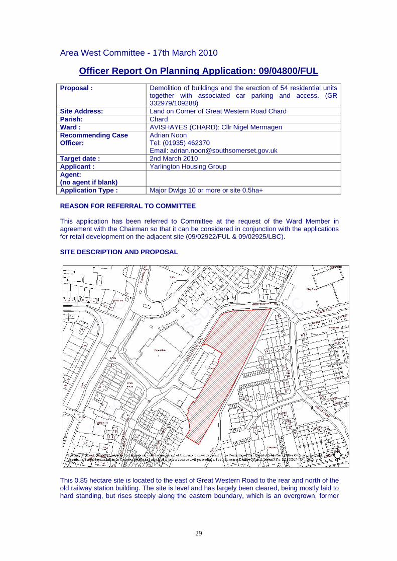
This 0.85 hectare site is located to the east of Great Western Road to the rear and north of the old railway station building. The site is level and has largely been cleared, being mostly laid to hard standing, but rises steeply along the eastern boundary, which is an overgrown, former
29

railway embankment. There are variety of trees (oak, sycamore and birch) on the embankment and a number of cypresses to the northern roadside boundary. To the west, on the opposite side of Great Western Road is the DIY store, to the north, again on the other side of Great Western Road, is new (post 2000) housing development. To the east, above the embankment is a footpath, beyond which is a range of garage courts at the rear of a 1960s/70s housing development. To the south are Henson Park and the 1980s housing development at Old Station Park, the nearest being 10-13 Old Station Park. Here the boundary includes a number of semi-mature trees. Only the garden of no.13 extends to the boundary of the site, nos. 10-12 being separated by an area of parking. The proposal is for the erection of 54 residential units, specified in the application forms as 41 ‘social rented’ and 13 ‘shared equity’ units, at a density of 61/ha, made up of:-
• 6 one-bedroom flats • 14 two-bedroom flats • 13 two-bedroom houses • 18 three-bedroom houses • 3 four-bedroom houses • 68 parking spaces (1 space per 1.26 units) • associated gardens, access/turning areas and public realm planting.
A footpath link would be created to the footway to the east of the site. The main access would be to the north of the former railway station building, with an internal road running north/south to the rear of the old railway station. The proposed buildings would be a mix of 2-storey, semi-detached and terraced houses creating a frontage along Great Western Road and along the western side of the internal estate road, with a row of 4 flats over garages (FOGs) cut into the embankment on the east side. A 3-storey apartment block with associated bin and cycle storage to the rear would be erected at the southern end of the site. The materials are stated as being a mix of red brick and render, with grey and red tiles. The application has been amended (28/01/10) and is supported by a Design and Access Statement, an Environmental Assessment Report, a Renewable Energy Statement, an Arboricultural Implications Assessment & Tree Protection Plan, a Ecology & Protected Species Survey, a Planning Statement incorporating a Statement of Community Involvement and a Transport Statement. The Ecology & Protected Species Survey has been updated to address clearance works that have been carried out and a planning obligations report, which includes a report prepared by the District Valuer based on 100% affordable units, funded by the Homes & Community Agency, has been provided. HISTORY There is a substantial history of the site dating from the 1960s and 70s when the site was in active use for general industrial purposes (manufacture of bitumen emulsion). More recently planning permission was granted for a steel stock shed (18/01/96, ref. 952507) in connection with a steel manufacturing use, again general industrial (B2) use. There are currently applications for the retail use of the former railway station building (09/02922/FUL & 09/02925/LBC). POLICY Section 38(6) of the Planning and Compulsory Purchase Act 2004 repeats the duty imposed under S54A of the Town and Country Planning Act 1990 and requires that decision must be made in accordance with relevant Development Plan Documents unless material considerations indicate otherwise.
30

For the purposes of determining current applications the local planning authority accords significant weight to the emerging Regional Spatial Strategy for the South West (RSS10) due to it highly advanced state. The view is therefore taken that the relevant development plan comprises the Draft Regional Spatial Strategy for the South West (Proposed Changes June 2008), the saved policies of the Somerset and Exmoor National Park Joint Structure Plan Review and the saved policies of the South Somerset Local Plan. The policies of most relevance to the proposal are: National Guidance PPS1 – Sustainable Development PPS3 – Housing PPG13 – Transport PPG17 – Planning for open space, sport and recreation PPS25 – Flooding Draft Regional Spatial Strategy for the South West (Proposed Changes June 2008): Development Policy B – Development at Market Towns Development Policy D – Required Infrastructure for Development Development Policy E - High Quality Design Development Policy G - Sustainable Construction Development Policy H - Reusing Land TR1 – Demand Management and Public Transport H1 – Affordable Housing H2 – Housing Densities RE5 – Renewable Energy and New Development Saved policies of the Somerset and Exmoor National Park Joint Structure Plan (April 2000): STR1 - Sustainable Development STR2 - Towns STR4 - Development in Towns Policy 33 - Provision for Housing Policy 35 - Affordable Housing Policy 37 - Facilities for Sport and Recreation within Settlements Policy 39 - Transport and Development Policy 40 - Town Strategies Policy 42 - Walking Policy 48 - Access and Parking Policy 49 - Transport Requirements of New Development Saved policies of the South Somerset Local Plan (April 2006): ST5 – General Principles of Development ST6 – The Quality of Development ST7 – Public Space ST9 – Crime Prevention ST10 – Planning Obligations EC3 – Landscape Character EC8 – Protected Species EU4 – Drainage EP1 – Pollution EP6 – Demolition and Construction Sites ME6 – Retention of Employment Land TP1 – New Development and Pedestrian Movement TP3 – Cycle Parking TP4 – Road Design
31

TP7 – Residential Car Parking Standards HG1 – Provision of New Housing Development HG4 – Density HG6 – Affordable Housing Targets HG7 – Affordable Housing Thresholds CR2 – Provision for Outdoor Playing Space and Amenity Space in New Development CR3 – Off-site provision CR4 – Amenity Open Space South Somerset Sustainable Community Strategy Goal 3 – Healthy Environments Goal 7 – Distinctiveness Goal 8 – High Quality Homes Goal 9 – A Balanced Housing Market Other Relevant Documents Chard Regeneration Plan, November 2009. CONSULTATIONS Chard Town Council – recommend approval subject to concerns over child safety and the need to provide a crossing of Great Western Road, the design layout of trees, and a suitable S.106 contribution for play facilities. Highways Officer – No objections are raised to the proposed access however there are concerns regarding the level and layout of the proposed parking serving the development:-
“The proposal provides sixty-eight spaces to serve the fifty-four units. According to the Somerset County Council Parking Strategy, given the composition of the dwellings proposed the development should be served by a maximum of 102 spaces. Whilst it is acknowledged that this value is a maximum the difference between the recommended and level provided is significant. “The Highway Authority also has concerns regarding the layout and arrangement of the proposed parking spaces. The Highway Authority has concerns that residents of the plots indicted as 42-50 on the submitted plan will park within the turning area as there is no off parking provision within close proximity. This will impact upon the ability for larger vehicles and refuse lorries being able to enter and leave the site in a forward gear. There are also concerns that given the limited number of spaces provided within the parking courtyard vehicles in connection with plots 2-18 are likely to either park on the proposed estate road in close proximity to the junction with Great Western Road or on Great Western Road itself which would not only interrupt the free flow of traffic but also add to the hazards for all road users. “It should also be noted that the Highway Authority has been consistent in its view that improvements to the pedestrian/cycle link and to its junction with Great Western Road to the east should be secured. The Highway Authority would wish to see improvements particularly the level of visibility achieved at this point.”
It is recommended that the application be refused on the grounds that the proposed parking arrangements are not satisfactory, however the highways officer goes on to observe that:-
“…if the Local Planning Authority deem the application appropriate and grant planning permission the following comments should be noted. The existing Furnham Road/ A30 signalised junction to the south of the site is of major importance with regards to the implementation of the Chard Regeneration Plan. As part of this phased development it has been identified that the existing signals will need to be upgraded by the installation of MOVA so as to improve the junctions capacity. Given that this junction at present is
32

almost at full capacity and that the new development will increase traffic movements through the junction it is felt appropriate that this development makes a contribution to its upgrading. Preliminary calculations suggest that the cost of such upgrading will be approximately £50,000. As a result unless the developer submits a Transport Assessment indicating that this specific development will not increase the use made of the Furnham Road/A30 junction the Highway Authority would wish to see a significant contribution provided.”
County Education Officer – notes that Chard Avishayes Primary School is forecast to be almost at capacity in the foreseeable future, without taking into account any further new development in the interim. The need for developer contributions will therefore remain even if the viability of this development is concluded to be of concern. Requests that a contribution of £134,827 be sought to address the need for 11 primary school places that this development would generate. Wessex Water – No objection Area Engineer – requires details in respect of drainage proposals, which will need to incorporate sustainable drainage techniques to reduce surface water run-off. Area Development Team – notes that the Chard Regeneration Plan is now in final draft and has been approved in principle by Chard Town Council as well as SSDC through JAC West. Concerns are voiced about the potential for additional traffic pressure on the main A30/A358 junction in Chard in relation to this application for 54 new homes.
“We feel that applications for Chard must be carefully considered in terms of the amount of remaining capacity that they effectively remove from this junction. They have the potential to frustrate the viability of the development to be brought forward under the plans laid out by LDA Design, which have been carefully constructed to manage pressure at this junction through the provision of required additional transport infrastructure in line with phased Key Site and Town Centre development. Our concern here is that we are putting so much into supporting a master planning process designed to accommodate sustainable growth while separate developments coming forward in the meantime have the potential to adversely alter the situation (traffic & financial data) on which the Regeneration Plan is constructed.”
In relation to the viability study submitted it is further commented that:-
“There is no credible evidence that the proposed development will not generate substantial additional traffic. The core principle of the Chard Regeneration Strategy, to which SSDC and Yarlington Homes are signed up, is that any new development must release not reduce traffic capacity as this proposal does. “If we allow this development to go ahead without addressing how the necessary traffic improvements will be provided and paid for, the whole basis of the CRS will be undermined. We simply cannot allow that to happen. The Social Benefits of Affordable Housing are insufficient.”
Spatial Policy Manager – in relation to viability report suggests that the proposal might need to be resubmitted to the District Valuer. Goes on to observe:-
“I feel that we have to add the transport obligation into the mix. Furthermore I feel that delivery of the needed junction upgrade is essential else the proposal would need to be refused in the light of the latest evidence. Someone was always going to be the first to be asked to contribute to the solution to the rapidly emerging problem….. If this argument is refuted …. then they should be asked to do a Transport Assessment to justify the proposal…….. If the scheme is unviable with all the obligations then the extent of obligations that it can afford needs to be determined by the DV. To my mind the Transport obligation is the prime obligation (as the scheme should be refused without it) and paid in full before other obligations are brought into the reckoning for payment. If the
33

scheme is unviable with obligations including the transport one then it should be refused.”
Corporate Strategic Housing Manager – welcomes the provision of 54 affordable units. With regard to the viability statement the following comments are offered:-
“It would appear that Raglans original view of likely grant levels was somewhat over bloated. The DV did take this into account in the original pass and offered an opinion on the degree of viability at grant levels (per unit) which I consider to be much more realistic. “What we now have, based on the YHG figures, does seem to me to be a more realistic take on likely grant figures. The grant figures quoted on the YHG version are not that different, in the same ballpark as our current rule of thumb and comparable bids they have recently submitted to the HCA (c £60k per rented unit; c £ 30K per shared ownership) “None of the above comments covers the other critical question - whether any HCA funding will be forthcoming at all. It is possible that the HCA will 'negotiate down' the pro rata funding, making the viability even tighter. [To conclude,] the quoted figures in YHG document re-grant funding not unreasonable; can't comment on how reasonable site development costs might be.”
Environmental Protection Unit – conditional approval. Leisure Policy Co-ordinator – recommends a contribution of £4,662.42 per dwelling be sought towards the provision of play and youth facilities, playing pitches, sports facilities and strategic community facilities to meet the demands arising from the occupiers of the additional 54 houses. Open Spaces Officer – requests a contribution at a rate of £237.50 per bedroom (total £27,550) to provided for enhancements to the neighbouring park to mitigate the additional wear and tear arising from increased use stemming from this development. The provision of the footpath link is welcomed. Landscape Architect – Conditional approval. Tree Officer – Considers the existing trees to be lesser quality ‘B-category’ specimens. Whilst the retention of such trees can be considered, the trees are compromised and cannot be described as 'special' or 'outstanding', which are the usual criteria for serving Tree Preservation Orders [which is the recommended method of securing the future of trees intended for retention in the long-term]. The emphasis with this site ought to be towards securing a high quality and sustainable scheme of tree planting. No objection is raised subject to securing a high quality and sustainable scheme of tree planting. Ecologist – accepts the recommendations of the updated report subject to conditions to safeguard nesting birds and to ensure the removal of Japanese knotweed, which has been identified on the site. Climate Change Officer – suggests that the installation of renewable energy equipment should be a condition of any planning permission achieved. Reservations are expressed regarding the layout and recommends that some buildings be reoriented to maximise the potential for solar gain. The use of wood chip boilers is recommended. REPRESENTATIONS 2 letters have been received raising the following objections:-
• Increased traffic and parking on already busy road; • New crossings would help;
34

• Increased strain on existing drains which already back up and frequently get blocked; • Impact of construction in terms of vibration; • Possible subsidence; • Boundary walls and security lighting needed; • Loss of amenity due to overlooking to properties in Old Station Court; • Overbearing relationship with properties in Old Station Court; • Loss of natural light and outlook to properties in Old Station Court; • Noise and disruption; • Loss of habitat; • Inaccurate details and lack of information.
One objector comments on the possible impact of the proposed office buildings. These are shown on land to the south of the site and do not form part of this application. Another resident welcomes the reduction in units (from the plans shown at the pre-application evening viewing) and is satisfied subject to consideration of drainage/sewerage, although concern is raised about increased traffic at the Great Western Road/Victoria Road junction. A fourth resident welcomes the chance to improve an eyesore but is concerned about possible overlooking and loss of trees and habitat. CONSIDERATIONS It is considered that the residential development of this general industrial site, which is close to residential development, is acceptable in principle. With regard to loss of employment land, it is noted that the former railway station building would remain in commercial use and that an area of land to the south of the site would remain for B1/B2/B8 use and it is considered that this would comply with policy ME6. The site could therefore potentially deliver housing that would contribute to the need and targets identified by policies HG1 and HG6, subject to consideration of:-
• Design and Detail • Layout and Landscaping • Access and Parking • Impact on Amenity • Developer Obligations
Design and Detail The proposed houses are considered to be of a design and proportions appropriate to the locality. Whilst the majority of the surrounding dwellings are 2-storey, it is not considered that the 3-storey apartment block would be unduly incongruous in this locality. It is set within the site and would not form part of the external street scene and would be on lower ground relative to the park to the east and houses to the south. The design and detailing of the proposed structures is considered acceptable, and subject to conditions to require the agreement of materials, detailing and landscaping, the impact on the character and appearance of the locality would be acceptable and in this respect the proposal complies with policies ST5 and ST6. Layout and Landscaping The loss of the existing trees is unfortunate; however as the tree officer notes they are not considered of sufficient quality to merit an insistence on their retention subject to a condition as recommended by the landscape architect, that would meet the requirements of the tree officer. On this basis the proposal would comply with policy EC3.
35

The layout would create a strong frontage to Great Western Road with houses fronting onto the top part of the footpath to the east. It is considered that this would create an improved street scene with an improved sense of security to the existing footpath and the new link to it. Internally the development would create a courtyard to the northern part of the site and an internal estate type road running to the south. All areas would benefit from suitable levels of natural surveillance. Plots 51-54 (FOGs) would be dug into the embankment and would have rear gardens at first floor level, the garaging being at ground level. Effectively the retaining wall would be incorporated within the built structure and the gardens would slope up to the eastern boundary. It is considered that this is an appropriate solution to the difficult levels in this part of the site that would enable a satisfactory layout to be achieved without unsightly retaining walls. It is considered that the proposed density is acceptable for this brownfield site, which is well within the settlement boundary. The proposed level of development is comparable to the Old Station Court, Henson Park and the newer development at Wyatt Way, which the Planning statement puts at 67, 49 and 58 per hectare respectively. It is accepted that the proposal provides no on-site open space, although there are modest areas of landscaping. These are not of a size or location that would be adopted by the District Council, however on the basis that the applicant is willing to provide for their future maintenance these are not considered objectionable, subject to a condition to ensure that appropriate management is agreed. The omission of on site informal open space would not normally be acceptable but it is noted that the site is adjacent to the park and would create a link directly to it. In this instance it is considered that this would adequately cater for the needs of future residents. The open spaces officer has suggested a contribution of £27,550 towards enhancements to mitigate any additional wear and tear. On this basis it is considered that the layout and landscaping comply with policies ST5, ST6, ST7, ST9, CR2, HG4, and CR4 Access and Parking The highways officer’s support for the general access arrangements is noted, however his objection to the levels of parking and the request for improvements to the junction of the cycle path and Great western Road are considered reasonable. The applicants have provided an amended layout and a further traffic statement (03/03/10), which argues that this is a sustainable location where parking levels should be interpreted as a maximum. The planning statement suggests that low levels of car ownership can be expected and therefore depressed parking provision is appropriate. The response of the highways officer was not available at the time of writing and an oral update will be necessary. Nevertheless, on the basis that the highways officer’s concerns are addressed it is considered that the development would comply with policies ST5, TP1, TP3, TP4 and TP7; the objection of local residents in respect of highways safety are not therefore considered sustainable. Impact on Amenity A number of concerns have been made with regard to the impact of construction works. Unfortunately construction by its very nature is disruptive and this can rarely, if ever, justify withholding permission. In this case it is considered that the imposition of a condition to require the agreement of a Construction Management Plan would reasonably enable the local planning authority to exert an appropriate degree of control of this phase of the development. Any damage to property arising from construction activities would be a civil matter between the developer and the affected party and is not a planning matter.
36

It is not considered that the northern or middle part of the site would have any adverse impact on the amenities of existing residents, there being adequate separation between these and the nearest dwellings. Concern has been raised about the impact of the 3-storey apartment block at the southern end of the site. This would be on lower ground relative to the existing buildings and it is considered that adequate separation would be maintained, which given the off set position of the proposed building relative to the existing dwellings would be sufficient to maintain the outlook of existing residents. There are however concerns about the potential for overlooking from the upper floors towards the rear garden of 13 Old Station Road. The applicant has been asked to reconsider the window arrangement to plots 46, 47, 49 and 50, to provide obscure glazing to the bathrooms and to move the kitchen windows to another elevation. Subject to these changes it is considered that the amenities of existing residents would be safeguarded as required by policy ST6. With regard to the amenities of future occupiers it is considered that all dwellings and FOGs would have adequate private amenity space and would not suffer any undue mutual overlooking. On a precautionary basis it is recommended that a condition be attached to any permission to prevent the subsequent insertion of first floor windows to the north elevation of plots 12 and 27, the south elevation of plot 23 or the west elevation of plot 7. It is considered that there is the potential for plots 23-28 to experience an unsatisfactory loss of privacy arising from the adjacent footpath, which is shown on higher ground. As the levels are being reduced in this area it is considered that this issue could be addressed by agreeing alternative levels that would achieve a better relationship. This could be secure by condition. On this basis it is considered that satisfactory levels of amenity would be provided for future occupiers as required by conditions ST5 and ST6. Developer Obligations The applicants have claimed that the contributions sought by the Leisure Policy Co-ordinator, Open Spaces Officer and County education authority would make the development unviable. At pre-application stage the proposal, as 100% affordable housing subsidised by the Homes and Communities Agency (HCA), was assessed by the District Valuer. It was considered then that, with the funding it was claimed was available, the proposal was viable with the requested contributions. The applicant’s Planning Obligations Statement now states that the level of funding available is much reduced. It is accepted that the cost of development has not changed significantly and the sole significant variable is the public funding. When the DV looked at the proposal in May 2009 he specifically commented that the assumptions about funding seemed inflated, but assumed that they had been researched. The opinion of the Council’s Corporate Strategic Housing Manager has therefore been sought on this issue. It is his opinion that the DV’s concerns were well placed; he therefore supports the applicant’s contention that the funding available is substantially below that previously claimed to be available. Accordingly allowing for a £25-35,000 reduction in HCA monies it is accepted that the development would not be viable if all the obligations were sought. As this is a windfall site and does not have associated expectations in relation to planning obligations it considered that the need to deliver much needed affordable housing in Chard must be balanced against other planning obligations. In this instance it is considered that the need for affordable housing outweighs other requests for education, open space and sports, arts and leisure contributions. Whilst it might be argued that a lower proportion of affordable house might enable other contributions to be made it should be remembered the applicant is an affordable housing provider.
37

In this instance it is therefore considered prudent to accept the higher proportion of affordable housing than would normally be expected (35%) without education and sports, arts and leisure contributions. However should any of the houses be developed for the open market it would be reasonable to expect the developer to make provision for these contributions. This could be achieved via an appropriately worded S.106 agreement. The one obligation that is considered essential is the need for a contribution towards improvements to the A30/A358 junction identified by the highways officer and area development team and supported by the spatial planning manager. The applicant accepts this position and has offered a contribution of £20,000. This is considered reasonable from a development of this size. On the basis of the above it is considered that a 100% affordable scheme, with a contribution of £20,000 to improvements to the A30/A358 junction and provision for contributions towards education, open space and sports, arts and leisure contributions in relation to any houses that are sold on the open market would comply with the requirements of policies ST10, CR3 and HG7. OTHER ISSUES It is considered that the drainage of the site could be adequately covered by condition, there being no insurmountable problems identified by the area engineer or Wessex Water. Whilst it is unfortunate that scrub clearance has already been carried out, the ecologist raised no objection subject to safeguarding conditions. Accordingly the objections that have been received on the grounds of drainage and habitat loss are not considered supportable. Finally the amended drawings (28/01/10) included additional sections, which are considered to adequately clarify any inaccuracies in the original submission. CONCLUSION It is considered that provision of 54 units of much needed affordable housing in Chard, which would contribute towards a balanced housing market as required by Goal 9 of the Sustainable Community Strategy, outweighs the failure to provide for education, open space and sports, arts and leisure contributions. The proposal is of an acceptable form, design and layout and subject to the amendments outlined above would have no negative impact on amenity and would not result in an unacceptable loss of employment land. There would be no adverse effects on highways safety, local drainage or ecology and the applicant has agreed to address the level of parking. On this basis this application is considered acceptable. SECTION 106 PLANNING OBLIGATIONS A Section 106 Agreement would be necessary to ensure that all the new houses are affordable and to ensure that Sports, Arts and Leisure contributions are made at the appropriate rate. RECOMMENDATION That, subject to no objection being raised to the parking arrangements by the highways officer and the receipt of amended drawings that satisfactorily address concerns about possible overlooking arising from the 3-storey apartment block, planning permission be granted subject to: (a) the prior completion of a Section 106 planning obligation (in a form acceptable to the
Council's solicitor(s)) before the decision notice granting planning permission is issued to:-
• ensure that an appropriate contribution is made towards junction
improvements at the A30/A358; • ensure the delivery of the development as 100% affordable homes;
38
• Provide for appropriate education, open space and sports, arts and leisure contributions in relation to any houses that are sold on the open market (no more than 65% to be sold);
b) the imposition of the planning conditions set out below on the grant of planning
permission. JUSTIFICATION The provision of 54 units of much needed affordable housing in Chard outweighs the failure to provide for education, open space and sports, arts and leisure contributions. The proposal is of an acceptable form, design and layout that would have no negative impact on amenity, ecology, highways safety or the supply of employment land. Adequate provision has been made for possible pollution and drainage. As such the proposal complies with policies ST5, ST6, ST7, ST9, ST10, EC3, EC8, EU4, EP1, EP6, ME6, TP1, TP3, TP4, TP7, HG1, HG4, HG7 and CR3 and would contribute towards Goals 3, 7, 8 and 9 of the South Somerset Sustainable Community Strategy. CONDITIONS 1. The development hereby permitted shall be begun within three years of the date of
this permission. Reason: To accord with the provisions of section 91(1) of the Town and Country
Planning Act 1990. 2. The development hereby permitted shall not be carried out otherwise than in complete
accordance with the plans and specifications submitted to the local planning authority on 01/12/09 as amended by updated ecology report and drawing numbers 2849/100 Rev E and 2849/SSAA B received 28/01/10.
Reason: To clarify the development hereby approved as the submitted plans have
been amended. 3. Unless otherwise agreed by the Local Planning Authority, development other than that
required to be carried out, as part of an approved scheme of remediation must not commence until conditions 4 to 6 have been complied with. If unexpected contamination is found after development has begun, development must be halted on that part of the site affected by the unexpected contamination to the extent specified by the Local Planning Authority in writing until condition 4 has been complied with in relation to that contamination.
Reason: To ensure that risks from land contamination to the future users of the land
and neighbouring land are minimised, together with those to controlled waters, property and ecological systems, and to ensure that the development can be carried out safely without unacceptable risks to workers, neighbours and other offsite receptors in accordance with saved policy EP1 of the South Somerset Local Plan (adopted April 2006).
4. A detailed remediation scheme to bring the site to a condition suitable for the intended
use by removing unacceptable risks to human health, buildings and other property and the natural and historical environment must be prepared, and is subject to the approval in writing of the Local Planning Authority. The scheme must include all works to be undertaken, proposed remediation objectives and remediation criteria, timetable of works and site management procedures. The scheme must ensure that the site will not qualify as contaminated land under Part 2A of the Environmental Protection Act 1990 in relation to the intended use of the land after remediation.
Reason: To ensure that risks from land contamination to the future users of the land
and neighbouring land are minimised, together with those to controlled
39

waters, property and ecological systems, and to ensure that the development can be carried out safely without unacceptable risks to workers, neighbours and other offsite receptors in accordance with saved policy EP1 of the South Somerset Local Plan (adopted April 2006).
5. The approved remediation scheme must be carried out in accordance with its terms
prior to the commencement of development other than that required to carry out remediation, unless otherwise agreed in writing by the Local Planning Authority. The Local Planning Authority must be given two weeks written notification of commencement of the remediation scheme works. Following completion of measures identified in the approved remediation scheme, a verification report (referred to in PPS23 as a validation report) that demonstrates the effectiveness of the remediation carried out must be produced, and is subject to the approval in writing of the Local Planning Authority.
Reason: To ensure that risks from land contamination to the future users of the land
and neighbouring land are minimised, together with those to controlled waters, property and ecological systems, and to ensure that the development can be carried out safely without unacceptable risks to workers, neighbours and other offsite receptors in accordance with saved policy EP1 of the South Somerset Local Plan (adopted April 2006).
6. In the event that contamination is found at any time when carrying out the approved
development that was not previously identified it must be reported in writing immediately to the Local Planning Authority. An investigation and risk assessment must be undertaken in accordance with the requirements of condition 1, and where remediation is necessary a remediation scheme must be prepared in accordance with the requirements of condition 2, which is subject to the approval in writing of the Local Planning Authority. Following completion of measures identified in the approved remediation scheme a verification report must be prepared, which is subject to the approval in writing of the Local Planning Authority in accordance with condition 3.
Reason: To ensure that risks from land contamination to the future users of the land
and neighbouring land are minimised, together with those to controlled waters, property and ecological systems, and to ensure that the development can be carried out safely without unacceptable risks to workers, neighbours and other offsite receptors in accordance with saved policy EP1 of the South Somerset Local Plan (adopted April 2006).
7. No development shall be undertaken unless a Construction and Environmental
Management Plan (CEMP) has been submitted to and approved in writing by the Local Planning Authority. The CEMP shall include details of the phasing of construction, hours of construction, routing for construction vehicles, parking for construction and contractors vehicles, measures to reduce noise and dust from the site together with other measures that will reduce the impact of the construction process on the locality. The development shall thereafter be carried out in accordance with such details unless otherwise agreed in writing by the Local Planning Authority.
Reason: To safeguard residential amenity in accordance with saved policies EP6 and
ST6 of the South Somerset Local Plan. 8. No development hereby approved shall be carried out until surface water drainage
details, including calculations, have been submitted to and approved in writing by the local\planning authority. Such details shall incorporate sustainable drainage techniques and once approved shall be fully implemented prior to the occupation of any of the units and shall be maintained in good working order at all times thereafter.
Reason: To ensure that the development is adequately drained in accordance with
saved policy EU4 of the south Somerset local Plan.
40

9. The development hereby permitted shall not be commenced until a landscaping
scheme, which shall include details of the species, siting and numbers to be planted, shall be submitted to and approved in writing by the Local Planning Authority. The scheme shall be completely carried out within the first available planting season from the date of commencement of the development, or as otherwise extended with the agreement in writing of the Local Planning Authority.
For a period of five years after the completion of the planting scheme, the trees and
shrubs shall be protected and maintained in a healthy weed free condition to the satisfaction of The Local Planning Authority and any trees or shrubs that cease to grow shall be replaced by trees or shrubs of similar size and species, or the appropriate trees or shrubs as may be approved in writing by the Local Planning Authority.
Reason: In the interests of visual amenity in accordance with saved policies ST5 and
ST6 of the South Somerset Local Plan. 10. The development hereby permitted shall not be commenced until particulars of the
materials (including the provision of samples where appropriate) to be used for external walls and roofs have been submitted to and approved in writing by the local planning authority. Once approved such details shall be fully implemented unless agreed otherwise in writing by the local planning authority.
Reason: In the interests of visual amenity in accordance with saved policies ST5 and
ST6 of the South Somerset Local Plan 11. Notwithstanding the details submitted no development shall be carried out until such
this as details of levels have been submitted to and agreed in writing by the local planning authority. Once approved such details shall be fully implemented unless agreed otherwise in writing by the local planning authority.
Reason: In the interests of visual and residential amenity in accordance with saved
policies ST5 and ST6 of the South Somerset Local Plan. 12. Notwithstanding the provisions of the Town and Country Planning (General Permitted
Development) Order 1995 (or any order revoking and re-enacting that Order with or without modification), no additional windows shall be formed above ground floor level to the north elevation of plots 12 and 27, the south elevation of plot 23 or the west elevation of plot 7.
Reason: To safeguard residential amenity in accordance with saved policy ST6 of the
South Somerset Local Plan. 13. The windows to the west elevation of flats 46 and 49 and the south elevation of plots
47 and 50 shall be fitted with obscure glazing and shall only be operable in a manner to be agreed in writing by the local planning authority. Once approved such details shall be fully implemented, and not subsequently changed unless agreed otherwise in writing by the local planning authority.
Reason: To safeguard residential amenity in accordance with saved policy ST6 of the
South Somerset Local Plan.
14. The development hereby permitted shall not be commenced until particulars of all boundary treatments and hard surfacing materials have been submitted to and approved in writing by the local planning authority. Such details shall include the use of porous materials to the parking and turning areas, were appropriate and once approved such details shall be fully implemented unless agreed otherwise in writing by the local planning authority.
41

Reason: In the interests of visual and residential amenity and to ensure the adequate drainage of the site and to mitigate any flood risk in accordance with saved policies ST5, ST6 and EU4 of the South Somerset Local Plan, adopted 2006.
15. No development hereby permitted shall take place until details of the solar thermal hot-
water systems (or other method of renewable power generation) have been submitted to and approved in writing by the local planning authority. Once approved such systems shall be fully installed and operational prior to the occupation of any dwelling hereby approved and shall be maintained in good working order at all times thereafter unless agreed otherwise in writing by the local planning authority.
Reason: In the interests of sustainable development in accordance with policy RE5 of
the emerging Regional Spatial Strategy (RSS10). 16. No removal of vegetation that may be used by nesting birds (trees, shrubs, hedges,
bramble, ivy or other climbing plants) nor works to or demolition of buildings or structures that may be used by nesting birds, shall be carried out between 1st March and 31st August inclusive in any year, unless previously checked by a competent person for the presence of nesting birds. If nests are encountered, the nests and eggs or birds, must not be disturbed until all young have left the nest.
Reason: To avoid disturbance to nesting birds thereby ensuring compliance with the Wildlife and Countryside Act 1981, as amended by the CROW Act 2000, and in accordance with Policy EC8 of the adopted South Somerset Local Plan.
17. The development hereby permitted shall not be commenced (including any further
ground works or site clearance) until further survey to determine the presence of Japanese Knotweed, and if present details of a scheme to eradicate Japanese Knotweed has been submitted to and approved in writing by the local planning authority. Once approved any eradication scheme shall be fully implemented prior to the commencement of development unless agreed otherwise in writing by the local planning authority.
Reason: In the interests of amenity in accordance with save policy ST6 of adopted
South Somerset Local Plan and in order to comply with legislation (The Wildlife and Countryside Act 1981).
18. The development hereby permitted shall not be occupied until a scheme of
management for the areas of landscaping has been submitted to and approved in writing by the local planning authority. Once approved such scheme shall be adhered to at all times thereafter unless agreed otherwise in writing by the local planning authority.
Reason: To ensure the suitable management of the landscaped areas in the interests
of visual amenity in accordance with saved policies ST5 and ST6 of the South Somerset Local Plan.
19. Possible highways conditions Informatives 1. The information required in relation to condition 9 should take into account the
comments of the Council’s tree officer, a copy of which is attached. 2. The levels details to be submitted in relation to condition 11 should demonstrate that
plots 23-28 would not be unduly overlooked by the footpath to the east of the site.
42