perry lakes management plan 2021-2031
TRANSCRIPT
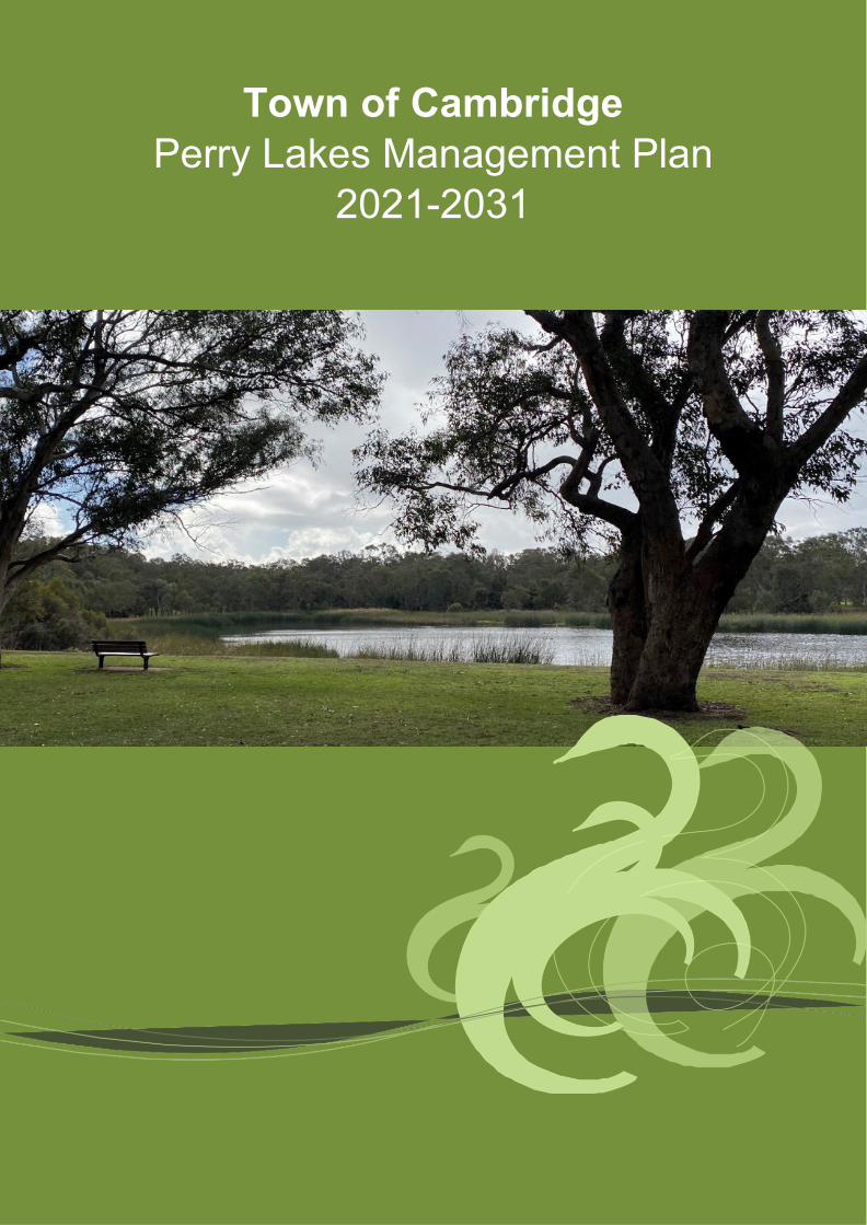
Town of Cambridge Perry Lakes Management Plan
2021-2031
Perry Lakes Management Plan 2021 - 2031
P a g e 2 | 66
Executive Summary Situated between Perry Lakes Estate, Oceanic Drive, Bold Park and Underwood Avenue, Perry Lakes Reserve in Floreat Western Australia is an iconic regional park with a rich history. The land now occupied by Perry Lakes Estate was home of the Athletic Stadium used during the Empire Games (Commonwealth Games) which were held in Perth in 1962. Over the last thirty years the water levels in both the east and west lake have declined to the point that both lakes are dry for many of the warmer months of the year. Perry Lakes water levels are directly influenced by groundwater levels in the superficial (Gnangara Mound) aquifer and directly impacted by changes in the water cycle. Significant impacts have been observed through increased water abstraction for irrigation and public drinking water and compounded by reduction in annual rainfall which is anticipated to further decline over the coming decades due to climate change. The Town is preparing to re-direct freshwater which is currently flowing out to sea north of Floreat Beach through a Water Corporation stormwater drain (Herdsman Main Drain) to both water bodies at Perry Lakes, this will provide localised groundwater recharge and increase levels in both lakes during the warmer and drier months of the year. As a result of this significant urban water management project there are a number of opportunities to reinvigorate the site through increased use and improved biodiversity values by implementing strategic management actions in this regional open space and conservation category wetland. This Management Plan aims to assist the Town of Cambridge in managing and improving the site over the next ten years to achieve the desired outcomes of the strategic community plan which include activating major public places to generate the most value from the Towns community facilities, education, access and management to enhance experience of the natural environment while also increasing climate change resilience all achieved with a locals first approach. The Town of Cambridge acknowledges the Traditional Owners (Whadjuk Noongar) of the land (Boodja) upon which we live and work and pay our respects to their Elders, past, present and emerging.
Perry Lakes Management Plan 2021 - 2031
P a g e 3 | 66
Table of Contents
1 Introduction ................................................................................................................................... 5
1.1 Background ............................................................................................................................. 5
2 Management Plan Objectives ...................................................................................................... 6
2.1 Site History .............................................................................................................................. 6
2.2 Biophysical Environment ......................................................................................................... 6
2.3 Environmental Threats ............................................................................................................ 6
2.4 Management Recommendations ............................................................................................ 6
2.5 Implementation Program ......................................................................................................... 6
2.6 Strategic Direction ................................................................................................................... 6
2.7 Community Stewardship ......................................................................................................... 6
2.8 Educational Resource ............................................................................................................. 6
3 Environmental Issues ................................................................................................................... 7
3.1 Water Levels ........................................................................................................................... 7
3.2 Loss of Biodiversity ................................................................................................................. 7
3.3 Conservation ........................................................................................................................... 7
3.4 Water Quality........................................................................................................................... 7
3.5 Weeds ..................................................................................................................................... 7
3.6 Fauna ...................................................................................................................................... 7
3.7 Trees ....................................................................................................................................... 7
3.8 Education ................................................................................................................................ 7
4 Recreational Issues ...................................................................................................................... 8
4.1 User Conflict ............................................................................................................................ 8
4.2 Accessibility ............................................................................................................................. 8
4.3 Public Safety ........................................................................................................................... 8
4.4 Activation ................................................................................................................................. 8
5 Strategic Context .......................................................................................................................... 8
5.1 Tenure and Zoning .................................................................................................................. 8
5.2 Town of Cambridge Strategic Framework .............................................................................. 8
5.3 Legal Framework .................................................................................................................... 9
6 Site History .................................................................................................................................. 10
6.1 Indigenous Land Use ............................................................................................................ 10
6.2 Post-European Land Use ...................................................................................................... 11
7 Regional Setting .......................................................................................................................... 13
7.1 Location and General Description ......................................................................................... 13

Perry Lakes Management Plan 2021 - 2031
P a g e 4 | 66
7.2 Regional Characteristics ....................................................................................................... 13
7.3 Surrounding Land Use .......................................................................................................... 14
8 Existing Biophysical Environment ............................................................................................ 15
8.1 Climate .................................................................................................................................. 15
8.2 Rainfall .................................................................................................................................. 15
8.3 Temperature .......................................................................................................................... 16
8.4 Changing Climate .................................................................................................................. 16
8.5 Wind ...................................................................................................................................... 16
8.6 Fire season ............................................................................................................................ 17
8.7 Geology and Geomorphology ............................................................................................... 17
9 Water Resources ......................................................................................................................... 19
9.1 Hydrogeology ........................................................................................................................ 19
9.2 Hydrology .............................................................................................................................. 19
10 Flora .............................................................................................................................................. 25
10.1 Original Vegetation ................................................................................................................ 25
10.2 Existing Vegetation Condition ............................................................................................... 25
10.3 Vegetation Types .................................................................................................................. 27
10.4 Conservation Significant Ecological Communities ................................................................ 28
10.5 Flora Diversity ....................................................................................................................... 28
10.6 Introduced Flora .................................................................................................................... 28
11 Fauna ............................................................................................................................................ 29
11.1 Fauna Diversity ..................................................................................................................... 29
11.2 Conservation significant fauna .............................................................................................. 29
11.3 Birds and other water dependent species ............................................................................. 29
11.4 Aquatic Invertebrates ............................................................................................................ 30
12 Management Strategies .............................................................................................................. 31
12.1 Water Management ............................................................................................................... 31
12.2 Flora Management ................................................................................................................ 32
12.3 Fauna Management .............................................................................................................. 34
12.4 Cultural and Recreational Facility Management ................................................................... 36
13 Implementation Program ............................................................................................................ 38
14 Appendices .................................................................................................................................. 49
15 References ................................................................................................................................... 66

Perry Lakes Management Plan 2021 - 2031
P a g e 5 | 66
1 Introduction 1.1 Background Perry Lakes Reserve is located approximately seven kilometres west of Perth CBD and covers a total of approximately eighty hectares. The Reserve is bounded by Oceanic Drive, Alderbury Street, Meagher Drive, Underwood Avenue and Perry Lakes Drive (see Appendix 1). The site encompasses two lakes covering approximately 12.6 hectares and surrounding parkland. The Reserve offers a range of passive recreation facilities including shaded picnic areas, paths, playgrounds, exercise facilities, barbecues and public toilets (see Appendices 2 – 5). Alderbury Reserve sits in the northern section of the site and includes playing fields, used for cricket and hockey, a dog exercise area and a skate park (see Appendix 6). The lake environment consists of a range of vegetation types including Closed to Open Sedgeland, submerged Eucalyptus Woodland featuring Eucalyptus rudis (flooded gum) and Melaleuca rhaphiophylla and clumps of Melaleuca species on lake banks. There are stands of open and closed Eucalyptus Forest dominated by Eucalyptus rudis, Agonis flexuosa and Melaleuca rhaphiophylla. The area surrounding the lakes is parkland and predominantly consists of open woodland with Eucalyptus gomphocephala (Tuart), Eucalyptus rudis (Flooded Gum), Agonis flexuosa (WA Peppermint), a number of Melaleuca species (Paperbarks) and introduced Pinus species (Pines). The vegetation within and surrounding the lakes has become highly modified due to a wide range of land uses since European settlement. The lakes have become isolated with increasing development and associated loss of vegetation. Clearing and development has resulted in changed lake hydrology and subsequent terrestrialisation of the lakes, altered vegetation composition and structure, and increased weed invasion. This Management Plan updates the original Management Plan developed for Perry Lakes and Alderbury Reserves in 2001. The plan describes the existing physical and biophysical environment and identifies and assesses the impacts of current land uses of the Reserves. This plan helps inform the management objectives, strategies, monitoring and reporting required for effective environmental management of the Reserves encompassing the two lakes and surrounding parkland.

Perry Lakes Management Plan 2021 - 2031
P a g e 6 | 66
2 Management Plan Objectives Taking into consideration the goals, strategies identified in the Community Strategic Plan, there is a need to align the management plan objectives desired over the next ten years. The objectives of the Perry Lakes Reserve Management 2021-2031 include: 2.1 Site History Provide background to Perry Lakes Reserve including the indigenous and European history; 2.2 Biophysical Environment Describe the biophysical environment, flora and fauna of the reserve and provide baseline data to inform future environmental planning; 2.3 Environmental Threats Describe the key environmental threats to the reserve and their impact on biodiversity and recreational values; 2.4 Management Recommendations Provide management recommendations to address environmental threats and improve the biodiversity and recreational values of the reserve 2.5 Implementation Program Present an implementation program which incorporates the management recommendations over a five year period; 2.6 Strategic Direction Provide strategic direction for future works through the development of a Masterplan; 2.7 Community Stewardship Encourage community stewardship of the site through the Adopt a Park program and the establishment of a Friends of Perry Lakes group; and 2.8 Educational Resource Promote Perry Lakes Reserve as a key environmental destination and educational resource within the Town.

Perry Lakes Management Plan 2021 - 2031
P a g e 7 | 66
3 Environmental Issues The major environmental issues identified at Perry Lakes and Alderbury Reserves are summarised below. 3.1 Water Levels The drop in water levels in both lakes resulting from the decline in groundwater levels of the Superficial Aquifer (Gnangara Mound); 3.2 Loss of Biodiversity The impact of dry lakes on the aesthetics of the site (Reduction in biodiversity of the flora and fauna); 3.3 Conservation Conservation of lake ecology and biological diversity in the area; 3.4 Water Quality Water quality issues related to inputs of nutrients, contaminants and the potential high bacterial levels associated with the large waterbird population on the lakes; 3.5 Weeds Invasive weeds impacts on both lakes, fringing vegetation and associated natural areas; 3.6 Fauna Conservation of fauna including birds, turtles, frogs and invertebrates; 3.7 Trees Tree management; and 3.8 Education School and community environmental education and awareness.
Perry Lakes Management Plan 2021 - 2031
P a g e 8 | 66
4 Recreational Issues 4.1 User Conflict Reducing the conflict between vehicles, pedestrians, cyclists and other park users; 4.2 Accessibility Ensuring accessibility compliance of paths and facilities for users of all ages and abilities (multigenerational) including wheelchairs, scooters, prams, skateboards, bikes and walking frames; 4.3 Public Safety The general safety and security of the users of the site and consideration of Crime Prevention Through Environmental Design (CPTED) principals; and 4.4 Activation Increased activation of the site for other user groups as determined through public consultation and stakeholder engagement. 5 Strategic Context 5.1 Tenure and Zoning The Town of Cambridge is the registered title holder of the fee simple estate of Perry Lakes Reserve. It consists of Lot 720 within the Town Planning Precinct P2 – Reabold. The legal description is, Lot 720, parcel 21069, Volume 2138 and Folio 16. The site covers an area of 584,752m2 (58.84ha). Perry Lakes Reserve is zoned Parks and Recreation in the Metropolitan Region Scheme (MRS) (see Appendix 7). It is also part of Bush Forever Site No 312 which covers 361.7ha of land primarily including Bold Park and Perry Lakes, stretching from The Boulevard in the north, Elphin Drive, Oceanic Drive, Alderbury and Brookdale Streets to the east, Underwood Avenue, Stephenson Avenue and Rochdale Road to the south and West Coast Highway, Oceanic Drive and Kalinda Drive to the west. Bold Park is located to the west of the site and is 437 hectares of Class A reserve. The eastern side of the reserve is bounded by the Perry Lakes Estate (Former 1962 Empire Games Stadium) which is zoned residential. Alderbury Reserve is located to the north and is zoned Parks and Recreation in the MRS. The suburb of Floreat is located north of Alderbury Reserve and is zoned residential. The Bendat Basketball Centre and WA Athletics Stadium are located on the southern side of Underwood Avenue and also zoned Parks and Recreation in the MRS. 5.2 Town of Cambridge Strategic Framework The following goals and strategies of the Town’s Strategic Community Plan 2018-2028 align with the objectives of the Perry Lakes Management Plan. Goal 1: A sense of community, pride and belonging
1.1 Encourage and support participation in a range of public activities and events where residents can gather and interact. 1.2 Promote our strong community identity and focus our responses on the needs of local residents, businesses and ratepayers.

Perry Lakes Management Plan 2021 - 2031
P a g e 9 | 66
Goal 2: Quality local parks and open spaces for the community to enjoy 2.1 Adopt a more strategic and coordinated approach to the planning of our parks and greenspaces recognising their diverse roles and local community preferences. 2.2 Improve the maintenance and provision of amenities in our local parks and district open spaces reflecting local values and priorities and the broader regional demand on facilities.
Goal 3: An active, safe and inclusive community
3.1 Focus on improving and expanding those places where community groups interact to encourage greater participation. 3.3 Encourage a range of activities that better align with the diverse needs of ratepayers of all ages, cultures and abilities. 3.4 Act to create and maintain safe, friendly and open environments that residents can access and enjoy.
Goal 7: The Town is environmentally responsible and leads by example
7.1 Manage our bushland areas to enhance and protect conservation values and protect our native animals and plant species 7.2 Optimise our use of ground water and improve the efficiency of our clean water consumption 7.5 Promote our environmental assets and opportunities and recognise the impacts of climate change in our strategies.
Goal 8 A community that embraces environmentally responsible practices
8.1 Encourage the community to self-manage minimising energy consumption, water use, emissions and waste.
5.3 Legal Framework Perry Lakes is managed within a statutory and policy framework. The applicable legislation, policies and guidelines are summarised in Appendix 8.

Perry Lakes Management Plan 2021 - 2031
P a g e 10 | 66
6 Site History 6.1 Indigenous Land Use Like all wetlands across the Swan Coastal Plain, Perry Lakes is believed to be an important place to the Whadjuk Noongar people. “The area now defined as Perry Lakes has been identified by the Department of Aboriginal Affairs, Aboriginal Heritage Inquiry System as Heritage Place 3735 as a former camp and hunting place. As a wetland it is logical this place was used by the Whadjuk Noongar peoples for a range of functions prior to and following establishment of the Swan River colony in 1829.” (see Appendix 7). The Noongar believed that the Swan River (Derbal Yerrigan) and wetlands such as Perry Lakes were created in the Cold Times (Nytting) by the Rainbow Serpent (Wagyl) as it entered and exited the country (Boodja). The water flowed from one water course to another connecting water across the landscape. Perry Lakes would have been an important meeting and camping place where the Whadjuk Noongar people would stop to eat and rest if they were travelling. It was a very rich place with plentiful vegetation and animals. It didn’t belong to any one group. It was a shared place. The lakes were a significant hunting ground for ducks, swans, cockatoos and long necked turtles. Kangaroo and emu were also hunted in the surrounding woodland using spears made from Kunzea ericafolia or glabrescens (Spearwood). Melalueca and Eucalyptus were used to build mia-mias while reeds were useful snorkels and provided edible tender shoots The Noongar People recognise six distinct seasons in South Western Australia which reflect the times of certain foods or locations for hunting. These six seasons are shown below in figure 1.
Figure 1 – Noongar six seasons, source - https://www.australiassouthwest.com/south-west-inspo/six-seasons-south-west

Perry Lakes Management Plan 2021 - 2031
P a g e 11 | 66
6.2 Post-European Land Use Perry Lakes is a registered heritage place (No 9008) with the State Heritage Council. “Henry Trigg, a carpenter and master builder from Gloucester, England arrived in the new colony of Western Australia in 1829. In I834, Trigg was granted 500 acres of land, which lay south of modern day Grantham Street, stretching from Floreat to the coastal sand hills. The western boundary of Trigg's land ran along the top of a limestone ridge. As a builder, Trigg recognised the value of this limestone outcropping and set up a quarrying and lime burning business. Trigg's business which became known as the 'Limekilns' prospered. In 1839, Trigg purchased neighbouring land to the south, including what is now Perry Lakes and One Tree Hill, (now known as Reabold Hill). In the same year, Trigg was appointed Superintendent of Public Works, and in this role was responsible for overseeing the erection of many early government buildings in Perth. In 1844, Walter Padbury, a pastoralist, acquired 426 acres of land adjacent to Trigg's property and later purchased Trigg's land including the Limekilns business for 2350, forming a 1,234 acre landholding which became known as the 'Limekilns Estate'. For the next 20 years Padbury built the Estate into a successful property, including the retention of the quarrying operations. At the height of operations, more than 50 men were employed at the quarry and lime kiln site. In 1869, brothers Henry and Somers Birch purchased the Limekilns Estate from Walter Padbury for £1,000. On 1 November 1875, during their ownership of the property, the explorer Ernest Giles arrived in Perth after his 2,500 mile journey from Port Augusta. His camels were rested at the Limekilns Estate and later in the 1890s, the Limekilns Estate served as a temporary quarantine station for camels imported to Western Australia to provide transport to the goldfields, with a lake now within Bold Park becoming known as Camel Lake. The Estate remained in the Birch's ownership until, 1880 when it was purchased by Joseph Perry for the sum of £1300. During his ownership, Perry kept the Quarry and limekilns in operation. Many of Perth's early public buildings, including the foundations of the Perth Town Hall (1870) were constructed using limestone from the quarry and kilns. In 1880, a portion of the Limekilns property was rented to Charles Ball who offered to supply lime which was described as the most superior in the colony, from lime kilns of 30 years standing. Private quarrying ceased operation in 1906 and the Limekilns Quarry (Quarry Amphitheatre) remained disused for many years. Changes to the rural nature of the area came about with the subdivision of land owned by the Catholic Church in 1911. This subdivision was called the Church Lands Estate, and the first house was constructed in 1912. In 1917, the Perth City Council purchased the 1290-acre Limekilns Estate from Perry for £18,000 and it linked to the Endowment Lands bestowed on the Perth City Council by the State Government in 1902. In January 1918, the Limekilns Estate was included within the boundaries of the City of Perth, and adjoined a further 2281 acres of Endowment Lands. The City envisioned opening out the quarries and using the limestone in the construction of city roads but also setting a portion of the land aside for a public park on the site of Perry's couch paddock and One Tree Hill (Reabold Hill).

Perry Lakes Management Plan 2021 - 2031
P a g e 12 | 66
The exact date that the municipal Quarry ceased operation is not known, but it is likely that operations ceased in the 1920s with the beginning of the development of the area for housing. During the middle decades of the 20th century the quarry was unused and largely inaccessible. In 1919, One Tree Hill was renamed Reabold Hill after F. R Rea, the Mayor of Perth at the time the property was acquired by the City of Perth and W. E. Bold, the town clerk. By this time the lone Tuart tree that had previously sat atop the 286 ft. high hill, and given the place its name had disappeared. In 1925, an area of land of approximately 1000 acres was set aside as a place of recreation and was named Bold Park in honour of William Ernest Bold (1873-1953), the retiring town clerk. Other sources have designated that the naming occurred in 1936. Perry Lakes was included in the original boundaries of Bold Park when it was established by the City of Perth. Perry Lakes in its current form dates from 1962 when the area was landscaped in association with the construction of Perry Lakes Stadium and associated sporting tracks and facilities for the 1962 Empire Games. The Perry Lakes Stadium was demolished from 2010 to 2012 and is now being developed for residential occupancy. The Perry Lakes Reserve has been redeveloped as part of the Perry Lakes redevelopment project. New facilities for passive and formal recreation have been built on the site included a skate park and a nature playground. Long term visitors to the Perry Lakes reserve have been groups of scouts and guides. The current Cambridge Scout and Guide Hall was built c2005 however prior to that fire pit has been located at the site for many years. Aerial photographs indicate the fire pit was present at the current location from the 1970s although further information is required to determine its date of construction. A commemorative sculpture is located within the grounds that honours 75 years of Scouting which occurred in 1982. The sculpture also acknowledges the 1979 world wide jamboree which saw 12000 scouts camp at the site. The Australian Scout Jamboree was again held on the site in 1994/95. The Town of Cambridge have instigated a management plan for the reserve with a particular focus on maintaining water levels which have been observed as declining in recent decades.” (InHerit 2021)
Perry Lakes Management Plan 2021 - 2031
P a g e 13 | 66
7 Regional Setting 7.1 Location and General Description Perry Lakes Reserve and Alderbury Reserve are located approximately 7 km to the west of Perth and cover a total area of approximately 80 hectares. Close to 12.6 hectares of this area is covered by the two lakes, West Lake being 5.9ha and East Lake being 6.7ha. The Reserves constitute a moderately developed, recreational parkland in the suburb of Floreat. The Reserves are bounded by Oceanic Drive to the north, Meagher Drive and Alderbury Street to the east, Perry Lakes Drive and Bold Park to the west and Underwood Avenue to the south. The landscape has parkland character dominated by the two lakes and surrounded by trees with no understorey. Recreational facilities within the Reserves include picnic areas, barbecues, playgrounds and fitness equipment and a sports ground. The site is serviced by numerous roads and car parking facilities to provide easy access for vehicles. The park provides many benefits to the surrounding urban environment including: • Visual Relief – by breaking up the uniform areas of suburbia; • Recreation – by enabling large numbers of people to pursue many kinds of recreational
pursuits such as walking, jogging, cycling, nature studies, picnics; • Conservation – the lakes and overall structure of the parkland provide a valuable habitat
for an abundance of wildlife and plants; and • Education – the landscape character provides a biological laboratory accessible to
schools, universities and the general public. 7.2 Regional Characteristics The wetlands of the Perry Lakes area were originally ephemeral like most wetlands of the Swan Coastal Plain. However during the era of tree clearing for firewood, construction and agricultural land, the groundwater levels increased around the wetlands. In 1962 landscaping, dredging and drainage works associated with the construction of Perry Lakes Stadium for the 1962 Commonwealth Games resulted in permanent water in the lakes. Since the 1970’s over abstraction of groundwater from the Gnangara Mound (shallow aquifer) for irrigation and drinking water has resulted in a drying wetland. Extensive weed invasion and a drying climate has displaced native species and contributed to further environmental decline. The East and West Lakes form the central feature of Perry Lakes Reserve. These lakes are semi-permanent, freshwater lakes which are located on the Swan Coastal Plain and are surface expressions of the shallow aquifer. Seasonal fluctuations in the height of the water table result in corresponding changes in the water levels of the lakes. In order to provide a range of water levels and depths in the lakes, West Lake has previously been allowed to dry out naturally during summer. Groundwater has been pumped into East Lake to maintain a year round water supply for local fauna. The diversion of water from the Herdsman Main drain will provide water in both lakes well into summer. Historical data suggests that the Reserve was originally part of a natural wetland system. The current landscape consists of a mixture of vegetation including benthic algae, aquatic and semi-aquatic plant life including, sedges, reeds, trees and grasses. The fauna of the lakes includes a wide range of water birds (both indigenous and non-indigenous species), turtles, frogs, fish and aquatic invertebrates.

Perry Lakes Management Plan 2021 - 2031
P a g e 14 | 66
Perry Lakes Reserve provides an environment for numerous recreational pursuits, many people visit the park each year, utilising the existing facilities available. Some of these activities include walking, running, cycling, bird watching, picnics, barbeques, parties and events which have included the Scouting Jamboree and Garden Week. Organised sporting activities including cricket, hockey, skateboarding, dog exercise and both formal and informal fitness classes, are held on the active space known as Alderbury sportsground to the north of the site. 7.3 Surrounding Land Use Major surrounding land uses include a residential area to the north and east of the Reserve, Bold Park which is an A Class reserve located to the west of Perry Lakes (Perry Lakes Drive separates the Reserve from Bold Park), and CSIRO, the State Basketball Stadium and HBF Stadium south of the reserve.

Perry Lakes Management Plan 2021 - 2031
P a g e 15 | 66
8 Existing Biophysical Environment 8.1 Climate Perth has a Mediterranean climate characterised by hot dry summers and mild, wet winters. Mean temperature and rainfall data for the period between 1994 and 2020 is provided below.
Figure 2. Mean Rainfall and Temperature Data for the Perth Area (1994 – 2020)
Source: Bureau of Meteorology. 8.2 Rainfall The pattern of rainfall is strongly seasonal with most rainfall occurring between May and October and the highest levels recorded in June and July. The average annual rainfall is 733.2 mm and has steadily declined since last century.
Figure 3. Mean Monthly Rainfall for Perth: 1994 – 2020
Source: Bureau of Meteorology
0
20
40
60
80
100
120
140
160
Jan Feb Mar Apr May Jun Jul Aug Sep Oct Nov Dec
Rain
fall
(mm
)
Month
Jan Feb Mar Apr May Jun Jul Aug Sep Oct Nov Dec Annual Mean Rainfall (mm)
19.1 13.4 19.7 35.2 87.7 127.8 144.5 125.5 82.8 38.8 21.7 10.6 733.2
Mean Max Temp (oC)
31.2 31.6 29.6 25.9 22.3 19.5 18.4 19.1 20.4 23.4 26.8 29.3 24.8
Mean Min Temp (oC)
18.1 18.4 16.8 13.8 10.4 8.6 7.9 8.3 9.5 11.6 14.4 16.4 12.8

Perry Lakes Management Plan 2021 - 2031
P a g e 16 | 66
8.3 Temperature Maximum temperatures in summer average 30.7oC while the minimum temperatures average 17.6oC. The maximum temperatures for winter average 19oC while the minimum temperatures average 8.3oC. Temperatures have gradually increased over the last century.
Figure 4. Mean Monthly Maximum Temperature for Perth: 1994 – 2020
Source: Bureau of Meteorology, 2020 8.4 Changing Climate Between 1910 and 2013 the average annual temperature in the south west of Western Australia has increased by 1.1oC (Department of Primary Industries and Regional Development, 2020). There has also been an increase in the number of hot spells (heatwaves) which the Bureau of Meteorology define as three or more consecutive days where the maximum and minimum temperatures are unusually high for the location (Department of Primary Industries and Regional Development, 2020). In Perth the frequency of heatwaves has generally increased. Between 1981 and 2011 the annual average intensity of hot spells increased by 1.5oC and the annual average number of heatwave days increased by three (Department of Primary Industries and Regional Development, 2020). Since 1970 there has been 20% decline in May to July rainfall in the southwest of Australia (CSIRO, 2020). This is also consistent with the 20% reduction in annual rainfall totals during the same period. The resulting outcome has been reductions of up to 80% in both streamflow and groundwater recharge of the superficial aquifer. Reduced water availability associated with the hotter and drier climate in the south west of Western Australia is placing greater stress on native flora and fauna. Several of the management actions in this plan aim to address declining water availability and improve ecosystem resilience. 8.5 Wind The winds are strongest during summer with 51% of winds in December exceeding 20km/hr at 1500 hours compared with only 20% in May and 25% in June, July and August (Bureau of
0
5
10
15
20
25
30
35
Jan Feb Mar Apr May Jun Jul Aug Sep Oct Nov Dec
Tem
pera
ture
o C
Month

Perry Lakes Management Plan 2021 - 2031
P a g e 17 | 66
Meteorology, 2020). The typical summer pattern is strong easterly winds in the morning swinging to a strong south-westerly wind or sea breeze in the afternoon. In February the ocean and land temperatures are closer resulting in a weaker sea breeze or no sea breeze at all. In late summer, dissipating tropical cyclones may also pass through Perth bringing rain and strong winds. During winter winds are generally lighter, the stronger westerly and north-westerly winds are associated with rain bearing depressions. 8.6 Fire season The fire season typically extends from September to early May. High to extreme fire danger periods occur from April to October. Lightening associated with summer thunderstorms can be an ignition source of bush fires. The combination of hot, dry, windy and lightening prone weather can result in severe fire risk in the region. Perry Lakes is not considered a designated Bushfire Prone Area by the Department of Planning, Lands and Heritage due to the understory of irrigated grasslands within the site. However the extreme western edge is impacted by Bold Park which is a designated Bushfire Prone Area. 8.7 Geology and Geomorphology Perry Lakes is located on the Swan Coastal Plain which lies on the eastern, onshore edge of the Perth Basin. The basin contains approximately 13,000m of Permian to Quarternary aged sedimentary rock. The uppermost plain formations are late Tertiary and Quarternary, comprising sand, limestone and interbedded silt and clay, up to 100m thick. The Swan Coastal Plain is characterised topographically by a series of distinct dunal systems aligned approximately north-south and extending from the coast to the Darling Scarp. The Quindalup and Spearwood Dune Systems lie closest to the coast, with the Bassendean Dune System further to the east. Wetlands occur in the intertidal depressions within and between these systems. Perry Lakes and Alderbury Reserves lie in an interdunal depression on the Spearwood Dune System. Churchwood and McArthur (1980) identified the following soil types in the area: 1. Karrakatta – undulating landscape with deep yellow sands over limestone 2. Cottesloe – low hilly landscape with shallow brown sands over limestone, much exposed
limestone. Department of Agriculture and Food (DAFWA 2008) identified three soil subsystems at the site: 1. Peaty clay – dark grey and black, soft, variable organic content, some quartz sand in
places or lacustrine origin. 2. Sand – pale and olive yellow, medium to coarse-grained, quartz, traces of feldspar,
moderately sorted and of residual origin. 3. Lake – Spearwood wet, lake phase. The superficial sediments of the Spearwood Dune System comprise aeolian calcernite (reverted Tamala Limestone) and are underlain be leached yellow sands of the Tamala Limestone. These sediments are typically pale brown to yellow calcernite, becoming more calcareous at depth. The sediments may yield large quantities of high quality groundwater and often have a capacity to absorb some contaminants, particularly phosphorus.

Perry Lakes Management Plan 2021 - 2031
P a g e 18 | 66
The Reserves lie at an altitude of approximately 6m AHD with a ground surface that is gently undulating with slopes of mostly less than 1o.
Figure 5. Soils of the Swan Coastal Plain
Source: Department of Agriculture and Food WA 2015
Perry Lakes Management Plan 2021 - 2031
P a g e 19 | 66
9 Water Resources 9.1 Hydrogeology The Quaternary sediments of the Swan Coastal Plain form a heterogeneous, unconfined aquifer which varies in composition both vertically and laterally. The aquifer is recharged from rainfall and drains laterally to the ocean and the Swan/Canning River System, and vertically to the underlying deep Leederville aquifer. Groundwater also leaves the shallow aquifer by evapotranspiration and extraction via irrigation bores. The combination of topography, sediment thickness and drainage has resulted in the formation of two superficial groundwater mounds, the Gnangara Mound and the Jandakot Mound within the Perth urban area. Both mounds have contributed to Perth’s water supply. Perry Lakes Reserve lies on the southern boundary of the Gnangara Mound. Regional groundwater flow is to the southwest at an average rate of 50-100m per year. Seasonal water table fluctuations in the vicinity of Perry Lakes occur over the range of approximately 2.5m AHD and 4.0m AHD. When the water table is higher than the water level of the lakes due to significant rainfall events, groundwater percolates into the lakes along their perimeters and through the lake bottom sediments. When the water level in the lakes is higher than the water table, water discharges from the lakes to the ground water system. The magnitude and direction of this flux depends upon the relative elevations of the lake surface and the local water table, the permeability of the lake bed and adjoining formations and the presence of low permeability layers in the superficial aquifer. Ground water levels as expressed in this groundwater dependant wetland have decreased over time with pressure from increased extraction and a drying climate. 9.2 Hydrology Lake Hydrogeology The Perry Lakes are shallow semi-permanent, freshwater lakes located in a topographical depression within grey and yellow quartz sands of the Swan Coastal Plain. The lakes are surface expressions of the shallow groundwater table. East Lake has a surface area of approximately 67,500m2 (6.75Ha) while West Lake has an area of approximately 59,375m2 (5.94Ha). The lakes are a modified remnant of a wetland which existed prior to European settlement and originally consisted of four distinct wetlands. Aerial photographs taken in 1953 indicate that the lakes contained abundant emergent vegetation and experienced a regular seasonal cycle of drying and filling (Townley et al., 1995). During very wet years West Lake expanded to cover the flats which now form Alderbury Reserve and East Lake flooded to an area now occupied by the Perry Lakes Estate. Permanent water only existed in the lakes after 1962 when dredging was conducted during the construction of the Perry Lakes Stadium (Townley et al., 1995). In the last 30 years the impact of a drying climate has resulted in seasonal drying of West Lake. The permanent water in East Lake is maintained using bore water.

Perry Lakes Management Plan 2021 - 2031
P a g e 20 | 66
Perry Lakes are considered to be flow-through lakes (groundwater dependant) and represent the most common form of wetland found on the Swan Coastal Plain. The ground water of a flow-through lake flows towards the lake on the up gradient side, generally discharging from the aquifer through the lake bed, close to the up gradient shore. On the down gradient side of the lake, water is recharged to the aquifer through the lake bed, again close to the down gradient shore. The groundwater in this area moves in a south westerly direction. The Swan River intercepts the Indian Ocean at an oblique angle. Groundwater entering the Perry Lakes sector of the superficial aquifer does so across an extremely small aquifer section between Herdsman Lake and Lake Monger. This water ultimately leaves the aquifer across a much larger section represented by the constant head boundary comprising the Indian Ocean and Swan River estuary. The Perry Lakes sector is therefore a zone of relatively low groundwater flow velocity and low water table gradients (Turner and Rich, 1999). Water levels in the lakes reflect the groundwater level in the aquifer close to the lakes. In the past when the lakes contained water throughout the year they appear to have functioned as permanent flow-through lakes. Recent declines in ground water levels with increased extraction and a drying climate have resulted in the lakes drying in late spring until replenishment from winter rains. The level in East Lake is currently maintained between 2.87 and 2.9m AHD through bore water input, however the future Herdsman Drain diversion will reduce the need for this reliance and result in a managed AHD of up to 3.8m in both lakes through an average input of approximately 5GL/day (except during periods of low flow in summer). This depth is regarded as ideal for managing water quality impacts. It will also ensure that the island (AHD 4.0m) in each lake is not inundated and can be used as by local fauna as a refuge. Surface Catchments and Drainage The lakes drain a surface catchment covering a total of 459.2ha. Six drains discharge storm water in to the lakes from the surrounding catchment area. The catchment of East Lake generates some surface runoff. Four stormwater outlets carry runoff from sealed areas in the carparks of CSIRO and some suburban streets of Floreat. The majority of paved surfaces in the East Lake catchment including Stephenson Ave, Brockway Road and Underwood Ave are drained by the Water Corporation Subiaco Main Drain which runs to the south of Stephenson Avenue and do not contribute runoff to the lakes (Dames and Moore, 1992). The West Lake catchment contains a greater area of paved surfaces than that of East Lake including Oceanic Drive and suburban streets in Floreat. The stormwater from these areas enters the lake via a stormwater drain at the northern end. Another smaller drain carries runoff from Perry Lakes Drive into the lake at its western side.

Perry Lakes Management Plan 2021 - 2031
P a g e 21 | 66
Figure 6. Catchment areas for Perry Lakes
Source: Town of Cambridge Historical Water Levels Significant hydrogeological modification of the lakes commenced in the 1950s when open storm water drains were dug into the lakes from new housing estates in Floreat and Wembley. This was followed by the construction of the sports stadium for the 1962 Commonwealth Games. As part of the development the lakes were extensively modified which included dredging and bank reclamation. Extensive grassed areas were established around both lakes and the first bores were established in 1962 for lawn irrigation (Turner and Rich, 1999). The modifications were carried out at a time of very high groundwater levels. Aerial images taken in 1962 show two oval sheets of water with distinct banks and no emergent vegetation. The lack of safe nesting areas for water birds prompted further modifications which included construction of an island in East Lake around 1984 and deepening and construction of an island in West Lake in the early 1980s. Drought during the 1970s contributed to a widespread decrease in groundwater levels throughout Perth. Portions of the lake beds became exposed over summer. A drying climate has contributed to an ongoing decline in groundwater and lake levels. Perth City Council resorted to pumping bore water into East Lake to maintain the lake level over summer. This is not a long-term sustainable solution however as it results in a greater head difference between the lake and the aquifer which accelerates seepage from the lake.

Perry Lakes Management Plan 2021 - 2031
P a g e 22 | 66
Diversion of stormwater from the Herdsman Main Drain to Perry Lakes via gravity drainage was considered in 1984 however the plan was rejected due to unacceptably high stormwater nutrient levels. Diversion of stormwater from the Herdsman Main Drain was considered again in 2019. Recent options propose managing nutrient levels by diverting water through a nutrient stripping vegetated bund and ongoing water quality monitoring to enable responsive management. Current Water Levels East Lake water levels are maintained through pumping of bore water into the lake. Pumping typically occurs between November and April. Over the summer 2019-20 around 75,000kL of water was pumped into East Lake. The level in East Lake is maintained at 2.87 – 2.9 AHD. West Lake is generally dry for half of the year, from mid-November to May/June and has become severely degraded from weed invasion. Location of Existing Recharge and Irrigation Bores There is currently eight production bores surrounding the lakes (see Appendix 9). Four bores service Perry Lakes Reserve, one of which is used to maintain the water level in East Lake during summer. This may not be required once the planned Herdsman Drain stormwater diversion is in place. Three bores service Alderbury Reserve and one bore services Perry Lakes Estate. Water Quality Water quality monitoring was undertaken immediately after first flush rainfall events in June 2019 and again at the end of May 2020. Ongoing water quality monitoring is critical for managing water quality and avoiding issues such as algal blooms. The results of the most recent sampling are summarised in the following sections. Surface water quality is compared to the ANZECC 95% trigger levels for toxicants in fresh water ANZECC (2018). Given the imminent diversion of the stormwater from the Herdsman Main Drain ongoing monitoring of water quality will be required to ensure long term water quality health. The pH of West Lake ranged from 7.8 – 8.07 indicating neutral to alkaline conditions. The pH of East Lake ranged from 5.9 - 5.97 indicating acidic conditions mostly likely the result of tannins (humic acid) from surrounding vegetation. The pH of the lakes has a significant impact on the availability and uptake of algal nutrients particularly phosphorous. High pH (above 8 or 9) is associated with high rates of release of phosphorus from lake bed sediments and correlated algal blooms. Total Dissolved Solids (TDS) provides an indication of the salinity of the water. TDS ranged between 500mg/L and 520mg/L in East Lake and 110mg/L and 330mg/L in the West Lake indicating fresh water conditions. Factors which can influence the salinity of the lakes includes inflow of stormwater, recharge from bores, groundwater quality, evapo-concentration during summer and ingress of seawater. Eutrophication is a common problem associated with wetlands on the Swan Coastal Plain. It refers to the process of excessive algal production and declining water quality associated with nutrient enrichment. Most Swan Coastal wetlands are vulnerable to eutrophication as they do not have outflows which results in nutrient accumulation.

Perry Lakes Management Plan 2021 - 2031
P a g e 23 | 66
Since European settlement there has been significant anthropogenic inputs of nutrients to wetlands through sewage, surface runoff, leaching of nutrients to groundwater from fertilisers applied in agriculture and domestic gardens and leachate from industry and landfill. The porous nature of soils of the Swan Coastal Plain has resulted in many wetlands in the region becoming enriched with nitrogen and phosphorus. The nutrient of greatest concern is phosphorus. It is the limiting nutrient in algal growth and high levels typically fuel algal blooms. As such it has the greatest capacity to contribute to eutrophication. Phosphorus enters the lakes in winter and becomes quickly bound to sediments. During summer microbiological activity in the sediments increases with warmer temperatures. This creates anaerobic conditions which result in phosphorus release from sediments into the water column where it can fuel algal blooms. Problems associated with algal blooms include deoxygenation which results in fish kills, algal odour, loss of aesthetic appeal, production of toxins, midge swarms, bird deaths through algal toxicity or botulism and potential health risks associated with people or animals coming into contact with water containing toxic algae Comparison of phosphorus levels with trophic state concentrations indicates that the lakes are mesotrophic. Greater inputs of phosphorus could increase the risk of the eutrophication therefore careful water quality management is essential to maintain healthy water bodies. The main sources of nutrients to Perry Lakes include storm water runoff, discharge from groundwater through the lake beds, inputs of bore water and direct run off from the immediate surroundings including nutrients from domestic gardens such as fertilisers, compost, manures, animal faeces, leaf litter and other organic materials. It is important for natural drying of the wetland to occur in order enable nutrients to settle and bind to the sediments. This will reduce the risk of algal blooms. With diversion of storm water from the Herdsman Main Drain water may persist in the lakes preventing drying and binding of nutrients in the sediments. The Town will need to monitor water levels and be aware of the increased risk of algal blooms and eutrophication if drying of the lakes does not occur. Heavy metals may enter the wetland through stormwater discharge or through groundwater inputs. Generally water bodies with high pH will not release heavy metals into the water column as they bind to the sediment layer. Recent sampling revealed that heavy metals levels generally do not exceed ANZECC guidelines. The majority of Iron will oxidise to form precipitates becoming available to vegetation through the lake bed sediment layer. This assists with consumption of nitrates and organic carbon which in turn increases plant growth. Iron levels in East Lake exceeded the limit of reporting in the last two rounds of testing (2018 & 2019) however this may be attributed to bore water inputs from the shallow aquifer and may lower over the next few years due to planned increased inputs from stormwater diversion, cessation of bore water inputs and wetland revegetation programs. The primary vehicle for hydrocarbons entry to the lakes is stormwater run-off from the surrounding road and drain network. The level of total recoverable hydrocarbons (TRH) exceeded the level of reporting in West Lake. TRH has not been detected in samples taken from the Herdsman Drain which will help reduce concentrations of TRH in both lakes once diverted. Groundwater contamination is a potential source of pesticide traces. Adverse impacts of pesticides include environmental contamination, long-term persistence, bioaccumulation and biomagnification within food chains and impacts on the ecological balance. Trace levels of pesticides have not been detected in either lake.

Perry Lakes Management Plan 2021 - 2031
P a g e 24 | 66
Bacterial levels from recent sampling vary widely between the two lakes. Faecal coliform levels in both lakes exceeded the ANZECC (2000) guideline for secondary contact fresh and marine waters. The level in West Lake was particularly high and may be related to dry conditions prior to sampling resulting in high concentrations of bird faeces in first flush rains. The levels in West Lake pose a threat to wildlife and human health however with increased input of water from the Herdsman Drain concentrations will lower as plant diversity and revegetation programs are undertaken. The sediments of the lakes consist of sand, silt, peat and clay in various compositions and range in thickness from approximately .05m – 1.5m. The rate of accumulation of sediments appears to be low. It should be noted that diversion of storm water from the Herdsman Main Drain may prevent drying of the lakes in summer and subsequent binding of nutrients in the sediment. Nutrients will remain in the water column which may potentially fuel algal growth and contribute to poor water quality.
Perry Lakes Management Plan 2021 - 2031
P a g e 25 | 66
10 Flora 10.1 Original Vegetation Historical aerial images and other records confirm that Perry Lakes were originally part of a natural wetland system. The lake surrounds were partly cleared with European settlement however complete clearing is believed to occur from 1962. Aerial images prior to 1962 suggest that the lakes supported fringing vegetation which included paperbarks, sedges and reeds as well as semi-aquatic and terrestrial species within the lakes (Dames and Moore, 1992). 10.2 Existing Vegetation Condition Perry Lakes Reserve is located within Bush Forever Site 312. A flora survey was conducted at Perry Lakes in June 2019. The results are summarised in the sections below. Vegetation condition was assessed in accordance with the vegetation condition rating scale for the South West and Interzone Botanical Provinces (EPA 2016). The scale consists of six rating levels which relate to the intactness of vegetation as shown in figure 7 below.
Condition South West and Interzone Botanical Provinces Description Pristine Pristine or nearly so, no obvious signs of damage caused by human
activities since European settlement Excellent Vegetation structure intact, disturbance affecting individual species and
weeds are non-aggressive species. Damage to trees caused by fire, the presence of non-aggressive weeds and occasional vehicle tracks
Very Good Vegetation structure altered, obvious signs of disturbance. Disturbance to vegetation structure caused by repeated fires, the presence of some more aggressive weeds, dieback, logging and grazing
Good Vegetation structure significantly altered by very obvious signs of multiple disturbances. Retains basic vegetation structure or ability to regenerate it. Disturbance to vegetation structure caused by very frequent fires, the presence of very aggressive weeds, partial clearing, dieback and grazing
Degraded Basic vegetation structure severely impacted by disturbance, Scope for regeneration but not to a state approaching good condition without intensive management. Disturbance to vegetation structure caused by very frequent fires, the presence of very aggressive weeds at high density, partial clearing, dieback and grazing.
Completely Degraded
The structure of vegetation is no longer intact and the area is completely or almost completely without native species. These areas are often describes as ‘parkland cleared’ with the flora comprising weed or crop species with isolated native trees or shrubs.
Figure 7: Vegetation condition rating scale for the South West and Interzone Botanical Provinces Source: GHD- Perry Lakes Monitoring Flora and Fauna Baseline Assessment – September 2019
The lakes and surrounding area have been highly modified as a result of historical uses of the lakes, clearing, urban development and changes to the natural hydrology. Vegetation mapping revealed that the site is in a Degraded to Completely Degraded condition due to the extent of weed invasion and the absence of understorey species. Dominant weed species include Cynodon dactylon (couch grass) and Cenchrus clandestinus (kikuyu grass) which dominate the lake bed in both lakes. The presence of Typha orientalis and Typha domingensis, both

Perry Lakes Management Plan 2021 - 2031
P a g e 26 | 66
native species, poses a threat to the site as both species are aggressive invaders which can transform wetland ecosystems unless actively managed. The woodland surrounding the lakes is parkland cleared. It consists of scattered trees dominated by local endemic species – Eucaplyptus rudis, E gomphocephala and Agonis flexuosa and also introduced Eucalyptus species, Pinus species and Melaleuca species. Vegetation condition of both lakes is shown in figure 8 and appendix 13.
Figure 8. Perry Lakes Reserve Vegetation Condition
Source: GHD- Perry Lakes Monitoring Flora and Fauna Baseline Assessment – September 2019

Perry Lakes Management Plan 2021 - 2031
P a g e 27 | 66
10.3 Vegetation Types Eight vegetation types were identified from vegetation mapping across the two lakes and the area immediately surrounding the wetlands as show in figure 8 and appendix 10.
Figure 9. Perry Lakes Reserve Vegetation Type
Source: GHD- Perry Lakes Monitoring Flora and Fauna Baseline Assessment – September 2019
Melaleuca species including Melaleuca raphiophylla, M. incana, M. nesophila and M. cuticularis occurring on the lake banks and partially submerged along the lake edges. The understorey has been cleared and is dominated by weed species including Cynodon dactylon (couch grass), Oxalis pes-caprae (soursob) and Hydrocotyle bonariensis (large leaf pennywort). The area around the lakes is parkland cleared dominated by local endemic species – Eucaplyptus rudis, E gomphocephala and Agonis flexuosa and also introduced Eucalyptus species, Pinus species and Melaleuca species. The understory is predominantly Cenchrus clandestinus (Kikuyu Grass) and Cynodon dactylon (couch grass). Sedgeland within the lakes include Schoenoplectus tabemaemontani (Grey Club Rush), Cyperus polystachyos (Bunchy Sedge), Typha species (Bull Rush), Baumea articulata (Jointed Rush), Bolboschoenus caldwellii (Marsh Club Rush) and Juncus pallidus (Pale Rush). These Sedgeland communities dominate the fringing open-water areas. Cynodon dactylon (couch grass) is also encroaching between the sedgelands and the margins of the wetlands. Fringing the lakes are closed forest of Eucalyptus rudis, Agonis flexuosa and Casuarina obesa over a largely bare understorey consisting of patches of dead grass and Hyrdocotyle bonariensis and scattered Juncus pallidus and Cyperus congestus.

Perry Lakes Management Plan 2021 - 2031
P a g e 28 | 66
Mixed forest is found on higher ground within the lake margins and consists of native and introduced Eucalyptus (dominated by E. rudis) and Melaleuca species over scattered Juncus pallidus over an understorey dominated by introduced grasses Cynodon dactylon, Cenchrus clandestinus, Lagurus ovatus (Hares Tail Grass). Scattered mixed trees (predominantly Eucalyptus rudis) over open to scattered sedges of Schoenoplectus tabernaemontani, Juncus pallidus, Typha species and Cyperus congestus over grassland of Cynodon dactylon and Cenchrus clandestinus over open herbland of Oxalis pes-caprae and Hydrocotyle bonariensis. Submerged Woodland of mixed native and introduced Eucalyptus species (predominantly E. rudis) and Melaleuca rhaphiophylla over scattered sedges of Cyperus congestus and Schoenoplectus tabernaemontani over scattered aquatic plants. The community is found within the seasonally inundated margins between the open water and the direr parkland areas. Open forest dominated by Eucalyptus rudis, Agonis flexuosa and Melaleuca rhaphiophylla over an understorey dominated by weedy grasses and herbs including Cynodon dactylon, Cenchrus clandestinus, Hyrdocotyle bonariensis, Oxalis per-carprae. This vegetation type occurs on higher ground within the lake margins in waterlogged soils and partially inundated areas. 10.4 Conservation Significant Ecological Communities The survey identified potentially two threatened ecological communities identified under the Environmental Protection and Biodiversity Conservation Act 1999 (Cth) (EPBC Act) within 5km of the survey area: Banksia Woodlands of the Swan Coastal Plain ecological community (Endangered) and Tuart (Eucalyptus gomphocephala) Woodlands and Forests of the Swan Coastal Plain ecological community (Critically Endangered). 10.5 Flora Diversity The survey identified a total of 66 flora taxa (including species and varieties) in and around the two lakes representing 29 families and 47 genera. The dominant families recorded include: Myrtaceae – 20 taxa, Cyperaceae – 7 taxa and Fabaceae – 6 taxa. The flora diversity recorded is not representative of the natural floristic diversity of the local area. The site is significantly degraded from weed invasion and a long history of disturbance including clearing. A comprehensive list of the flora identified in the survey is provided in Appendix 11. 10.6 Introduced Flora Thirty eight introduced/naturalised flora taxa were recorded in the survey area. One species, Bridal Creeper (Asparagus asparagoides) is listed as a Declared Pest under the Biosecurity and Management Act 2007(BAM Act) and Weeds of National Significance (WoNS). Many of the introduced flora are invasive environmental weeds which pose a threat to the ecological integrity of Perry Lakes. These weeds outcompete native flora and modify suitable habitat or food resources for native fauna. Ongoing weed control ahead of the diversion of stormwater from the Herdsman Main Drain is necessary to improve ecosystem health and resilience.
Perry Lakes Management Plan 2021 - 2031
P a g e 29 | 66
11 Fauna 11.1 Fauna Diversity The field survey identified 43 fauna species in the survey area including 37 bird, two mammal, three amphibian and one reptile species. Six of the species recorded were introduced. A list of the fauna recorded is provided Appendix 12. 11.2 Conservation significant fauna There were no threatened or priority fauna identified within the survey area during the field survey. Fifty conservation significant fauna, excluding migratory birds, were identified in desktop searches as potentially occurring in the survey area. Of this fauna five are considered likely or possible to occur in the survey area and surrounding vegetation include, Forest Red-tailed Black Cockatoo (Calyptorhynchus banksii subspecies naso) – Endangered, Carnaby’s Cockatoo, White-tailed Short-billed Black Cockatoo (Calyptorhynchus latirostris) – Endangered, Australasian Bittern (Botaurus poiciloptilus) – Endangered, Peregrine Falcon (Falco peregrinus) – Other Specially Protected Fauna, Blue-billed duck Oxyura australis) – Priority 4. It was noted that a number of Migratory listed birds (EPBC listed International Agreement, IA) may occasionally visit the area such as common sandpipers (Actitis hypoleucos) and greenshanks (Trings nebularia). The lakes are a known drought refuge for waterbirds. Diversion of stormwater into the lake is likely to support a greater water bird population. 11.3 Birds and other water dependent species Open freshwater areas and fringing vegetation provide important habitat and food resources for fauna particularly waterbirds, frogs, turtles, fish and invertebrates. The fringing sedgelands provide nursery for fish and breeding habitat for fauna particularly waterbirds such as the Black Swan, Purple Swamphen and Dusky Moorhen. The wetlands provide suitable habitat for the Australasian Bittern, Peregrine Falcon and a number of migratory birds listed under the EPBC Act and Biodiversity Conservation Act 2016 (WA). Drying of the lakes over time has resulted in terrestrialisation of the vegetation within the lakes and reduced the suitable habitat for water birds and other water dependent species. The woodland area surrounding the lakes provides food resources and habitat for a number of bird species particularly the tree canopy and clumps of Melaleuca and Acacia. The Eucalyptus species, particularly Tuart, Marri and Flooded Gum provide foraging, roosting and potentially breeding habitat for the endangered Carnaby’s Cockatoo and Forest Red-tailed Black Cockatoo. These Eucalyptus species also provide suitable habitat for the Peregrine Falcon. The grasslands areas around the lake periphery may be used as hunting grounds by birds of prey. The lack of understory offers little structural diversity and micro-habitats to support a greater diversity of bird species.

Perry Lakes Management Plan 2021 - 2031
P a g e 30 | 66
11.4 Aquatic Invertebrates A baseline aquatic macroinvertebrate survey of the Perry Lakes was conducted in August 2019. It provides a snapshot of the current diversity and health of the aquatic macroinvertebrates in the lakes. Sampling was undertaken across all available habitats in each lake including open water, Bulrush (Typha orientalis), sedge (Baumea articulata), riparian and storm water inlet. The survey identified five phyla, seven classes, 10 orders and 16 families. The most abundant families are summarised in figure 9 below.
Family Number of individuals Daphiniiae (Cladocera) 4140 Ostracoda 2615 Copepoda 91
Figure 10. Macroinvertebrate Families of Perry Lakes Invertebrate Solutions Pty Ltd - Aquatic Macroinvertebrate baseline monitoring,
The most diverse aquatic assemblage was found within Baumea articulata sedge in East Lake where 13 families were recorded. Ten families were recorded within the riparian habitat in East Lake while eight families each were recorded within the storm water inlet habitats in both lakes. The average family diversity in East Lake across all habitats sampled was 8.6 families while it was 6.6 in West Lake. Greater family diversity in East Lake may be associated with water quality that is more suited to aquatic macroinvertebrates when compared with West Lake. East Lake water levels are supplemented by bore water which is likely to boost species richness. West Lake dries out in the summer which may explain the lower species count.

Perry Lakes Management Plan 2021 - 2031
P a g e 31 | 66
12 Management Strategies 12.1 Water Management Management Aims and Objectives The objectives for the management of water quality and lake levels in Perry Lakes include: 1. Enhance water quality in both lakes; 2. Investigate exceedances of ANZECC trigger values to determine causes and implement
appropriate management responses to address the exceedances; 3. Improve water levels in both lakes; 4. Manage the lakes as a Conservation Category Wetland; 5. Increase efficiency of Perry Lakes and Alderbury Sportsground irrigation systems; and 6. Educate the community about waterwise irrigation and garden design. 12.1.1 Groundwater The lakes have been highly modified over time. West Lake in particular has suffered from extensive weed invasion and declining water levels with a drying climate and bore water extraction. East Lake has suffered less decline as it has been artificially maintained during summer as a drought refuge for water birds and to support other fauna such as the South Western Snake-necked Turtle. Improvements in lake levels, weed control and revegetation of the lake bed, edges and buffers, particularly West Lake, will improve water quality and overall wetland health. The West Lake of Perry Lakes currently dries out in summer. The East Lake level is artificially maintained during summer through bore water pumping. The water quality of the lakes is generally within ANZECC Guidelines and within the range exhibited by other Perth wetlands. Water quality can be improved by minimising fertiliser application and irrigation of turf areas, frequent street sweeping and encouraging residents to minimise fertilising and irrigation of their gardens. Ongoing water quality monitoring will also aid in identifying any water quality issues and informing management actions. In addition, ongoing macro-invertebrate monitoring may act as an indicator of wetland health. Management Recommendations Recommendations include: 1. Divert stormwater from Water Corporations Herdsman Main Drain which currently
discharges to the Indian Ocean to improve the water level of the lakes; 2. Continue to undertake a water quality monitoring program as a key indicator of wetland
health; 3. Continue to monitor lake water levels; 4. Develop management responses to address any exceedances of ANZECC trigger
values 5. Continue to undertake macroinvertebrate sampling as an indicator of wetland health. 6. Implement sediment control at the drainage outlets of each lake 7. Cease bore water supplementation of East Lake if the storm water input is sufficient to
maintain water levels over summer. 8. Develop a nutrient and irrigation management plan (NIMP), annual reporting of leaf and
soil nutrient levels, water extraction and water quality testing of ground water bores.

Perry Lakes Management Plan 2021 - 2031
P a g e 32 | 66
9. Revegetate lake banks and buffers where weeds have been removed to stabilise banks and facilitate nutrient stripping and improved water clarity.
12.1.2 Irrigation Groundwater and levels have been impacted by bore water use, particularly with the proliferation of private bores. Improvements in irrigation efficiency have assisted in reducing bore water consumption however the impact of a drying climate has continued to put pressure on ground water levels. Private bores place significant pressure on the superficial aquifer. By continuing to support the Waterwise Council, Golf Course and Pool programs along with regular community workshops and education regarding groundwater efficiency the impacts from abstraction can be reduced. The current irrigation infrastructure at the site is aged, inefficient and in need of upgrades and redesign. Currently there is a section near Bold Park Drive which is unirrigated and other areas very close to the lake (Buffer areas) are watered with overspray going into the lakes. Irrigation of the lake buffer areas increases the likelihood weed invasion. It is anticipated that by modifying irrigation will also improve turf health, conserve ground water and decrease abstraction. Management Recommendations Recommendations include: 1. Reduce areas irrigated within the buffer around the lake; 2. Replace aged irrigation infrastructure with a smart irrigation system; 3. Conduct regular bore and pump maintenance; and 4. Educate the community about waterwise initiatives including efficient irrigation design,
soil improvement and low water demand landscaping. 12.2 Flora Management Management Aims and Objectives The objectives for the management of flora at Perry Lakes include: 1. Improve the abundance and richness of native endemic floral species of the Lakes; 2. Reduce invasive exotic grasses, herbaceous weeds an woody weeds through targeted
chemical weed control and hand weeding; 3. Manage plant pathogens; 4. Improve habitat diversity for local fauna species; and 5. Mitigate risks of fire. 12.2.1 Trees The site has good cover of semi mature eucalypts including Flooded Gum and Tuarts, and paperbarks fringing the waterbodies which would naturally occur in this environment. Careful consideration needs to be given to placement of new trees to avoid overcrowded or dense canopy cover which can adversely impact turf health, quality and increase weed invasion within turf areas.

Perry Lakes Management Plan 2021 - 2031
P a g e 33 | 66
Canopy cover over the lake bodies conversely can increased to reduce impacts from the sunlight on water quality and temperature which can reduce likelihood of eutrophication and botulism outbreaks in the wildlife. However there needs to be careful placement of new trees to ensure areas of open water remain for water birds to land, tortoises and reptiles to bask and wide range of habitats for all fauna Long-term management focuses on retaining, conserving and enhancing the significant parkland. It includes managing trees to promote sound health, improve public safety and indigenous planting to improve a mixed age class of the urban forest. Management Recommendations Recommendations include: 1. Conduct annual visual tree inspections; 2. Develop a Significant Tree Register; 3. Undertake strategic tree planting within the reserve; and 4. Provide avenue street tree planting in surrounding street verges. 12.2.2 Weed and Pathogens The invasion of weeds is a significant management issue for the wetlands of Perry Lakes and the surrounding area. Invasive weeds out-compete native flora and impact biodiversity values of the lakes. Weeds compete with native plant species for space and moisture and usually do not provide suitable habitat or food resource for native fauna. West Lake in particular has become highly infested with weeds. As a result a significant area of the lake is completely degraded as illustrated by the map of vegetation condition in Appendix 11. A flora and fauna survey was conducted in 2019 which documented weed species to be targeted. This will assist in identifying weed management priorities. Ongoing weed management and monitoring is required to eradicate weeds and maximise revegetation success. Water levels should be monitored to determine effects on vegetation particularly Eucalyptus rudis. Mulching is an important part of weed suppression however careful consideration of pathogens such as phytophthora needs to be managed through good hygiene and composting of material. Management Recommendations Recommendations include: 1. Undertake weed mapping of the natural areas and update every five years; 2. Ensure regular weed monitoring to track effectiveness; 3. Undertake weed control according to Australian Pesticide and Veterinary Medical
Authority (APVMA) and Department of Health guidelines; and 4. Develop a phytophthora management procedure. 12.2.3 Endemic Vegetation The southern end of the East Lake has some vegetation in reasonable condition as seen in Appendix 13. Much of the remaining wetlands have been degraded due to rapid lowering of water levels resulting in a loss of naturally occurring wetland species. The invasion of weeds

Perry Lakes Management Plan 2021 - 2031
P a g e 34 | 66
has not only been exacerbated by irrigation and hydrological changes but also through the loss and lack of buffer vegetation necessary for a healthy Conservation Category Wetland. Best practice recommends a fifty metre buffer of natural vegetation which encompass the lakes to provide habitat for breeding tortoises, frogs, birds and reptiles. This also has the added effect of reducing weed invasion into the nutrient rich and moist soils which increases weed vigour and germination. However, as the community have been used to open access to the lake edges for a number of decades careful planning of access to the lake surrounds for both conservation and recreation will need to occur. Sections of the lake buffer should be mulched and planted with low growing floristic vegetation to allow wetland and wildflower views. Installation of limestone paths and lookouts onto the lake edge will provide closer access to the water to retain human connection. Some areas should remain grassed to provide a number of different recreational experiences within the site. Management Recommendations Recommendations include: 1. Convert areas of turf within lake buffers to native vegetation; 2. Develop a revegetation plan for Perry Lakes to improve flora species abundance and
richness within the wetlands and within the wetland buffer zone; 3. Revegetate the lake beds, banks and buffers to improve species diversity and wetland
habitat value; 4. Develop a vegetation monitoring program to track rehabilitation success – including
winter and summer photo monitoring; and 5. Undertake vegetation surveys at five year intervals. 12.2.4 Fire Perry Lakes is adjacent to Bold Park which is identified as a bushfire prone area. As there is a significant amount of irrigated and manicured turf within the site the reserve itself is not considered a bushfire prone site. Once the stormwater diversion project is completed the waterbodies will provide further relief from the risks of fire. Revegetation planning will need to ensure that a buffer of irrigated turf is provided where practical to help mitigate the risk of uncontrolled fire within the reserve. Roads which surround the waterbodies will act as a fire break and access for any fire suppression work required. Management Recommendations Recommendations include: 1. Monitor fuel loads 2. Undertake weed control and slashing of grasses to reduce fuel load 3. Selectively remove dead branches to reduce fuel load but retain some for fauna habitat. 4. Maintain firebreaks between the Reserve and the Perry Lakes Estate 12.3 Fauna Management Perry Lakes is an important habitat and drought refuge for water birds, turtles, reptiles and frogs. The loss of habitat through drying of the lakes impacts significantly on water bird

Perry Lakes Management Plan 2021 - 2031
P a g e 35 | 66
populations. It is recommended that management strategies focus on determining and maintaining the habitat requirements of local bird species. It is also recommended that species information is placed in the notice boards around the lake to educate the community about the habitat and food requirements of species found at the lakes. Introduced bird species such as rainbow lorikeets can significantly impact on the ecological and recreational values of the reserve by competing with local birds for food and habitat. Monitoring of pest species is recommended to determine impacts on native bird species. It is also important that nutrient levels in the lakes are regularly monitored to help prevent outbreaks of avian botulism. Signage educating about the impacts of feeding waterbirds should be installed around the lakes to help reduce impacts to water quality. Baseline water quality sampling was undertaken in June 2019. Ongoing water quality and macroinvertebrate monitoring will aid in managing water quality. Long-neck turtles (Chelodina oblonga) are found within the East Lake at Perry Lakes. Good nesting sites adjacent to the lakes are necessary for breeding. Perry Lakes does not experience the road fatalities of other wetlands due to the abundance of nesting opportunities within the parkland. It is recommended however that the earth banks and gentle slopes are maintained along the shore line with some gaps in the vegetation to facilitate the movement of females for nesting. Dogs are required to be on leash within the reserve with the exception of the off leash dog exercise area on the east side of Alderbury Reserve. Dogs off lead can interfere with wildlife and other reserve users. As water levels in the lakes increase there may be a need to provide fencing along the buffer edge to stop dogs entering the waterbody. Cats may also impact on native species within the Reserve, particularly birds. It is recommended that the Town continue to raise awareness of responsible dog and cat ownership including registration, sterilisation, microchipping, vaccination and confinement at night. Management Aims and Objectives The following management objectives aim to support fauna and improve biodiversity. 1. Undertake measures to support Chelodina colliei (Southwestern Snake-necked Turtle)
habitat; 2. Implement measures to support birdlife; 3. Provide a diversity of habitats to support a diverse range of local fauna; and 4. Work with the community and schools to support local faunal biodiversity. Management Recommendations Recommendations include: 1. Undertake biennial fauna surveys and compare to baseline fauna survey data; 2. Undertake annual macroinvertebrate surveys as an indicator of wetland health; 3. Assess and ameliorate lake banks to facilitate turtle nesting; 4. Initiate and engage the friends group to monitor turtle nesting and conduct annual
surveys of Chelodina colliei; 5. Monitor and control feral pests such as foxes, rabbits, feral cats, lorikeets and honey
bees; 6. Monitor and manage mosquito and midge larvae in the Lakes; 7. Enforce the Dog Act and Town of Cambridge Animals Local Law to ensure dog lead
compliance in on-lead areas;

Perry Lakes Management Plan 2021 - 2031
P a g e 36 | 66
8. Assess the need for fencing between the dog exercise area and lake; and 9. Construct and install fauna attracting structures - insect hotels, bat boxes, bird boxes
and Carnaby's Cockatoo nesting hollows 12.4 Cultural and Recreational Facility Management The major facilities at Perry Lakes include the scout hall, sports pavilion, the skate-park, half-court basketball, fitness equipment, toilets, playgrounds, barbecues, picnic tables, bins and the Alderbury Sportsgrounds which host hockey and cricket clubs. Maintenance of these facilities maximises the recreational experience. Management Aims and Objectives The management aims and objectives associated with the cultural and recreational values of Perry Lakes include: 1. Provide appropriate infrastructure that caters for the varied uses of the Reserve; 2. Manage the site as a mixed-use public open space with environmental, cultural, sporting
and recreational uses and values; 3. Preserve the wetlands as a Conservation Category Wetland; 4. Recognise the social and cultural values of the Reserve held by the community; and 5. Recognise the Indigenous and European heritage values of the Reserve. 12.4.1 Access Rationalisation of roads and parking within Perry Lakes Reserve may improve safety and access to the reserve. Wheelchair and pram access to well utilised areas such as barbecues, picnic and playground areas should also be improved to increase activation of the site. Completion of walking trails around both lakes will increase pedestrian use, safety and reduce conflict with vehicles. Management Recommendations Recommended actions include: 1. Complete the remaining connections of the internal circuit path as proposed in the
Alderbury Sports Ground Masterplan; 2. Provide accessible pathway connections to BBQ, Picnic, Playgrounds and seating within
the reserve; 3. Install directional signage to key internal features of the reserve such as Toilets,
playgrounds, barbecues and picnic areas, and to key external features such as Bus stops, Floreat Forum and Bold Park;
4. Install site map signs at the main entrances to the reserve identifying key features of the reserve;
5. Regularly update the Perry Lakes display boards with information about the Reserve; and
6. Install viewing platforms and educational signage at key locations at each lake to permit the public to get a closer view and appreciation of the flora and fauna of the wetlands.

Perry Lakes Management Plan 2021 - 2031
P a g e 37 | 66
12.4.2 Sport and Recreation The lakes and surrounding parkland are major passive recreation attractors to the site. The natural environment provides opportunities for nature appreciation while barbecues and playgrounds provide picnic and family recreation opportunities. Seasonal sports are conducted on the playing fields of Alderbury Reserve. Other sporting opportunities include the skate park and basketball half court located on the edge of Alderbury Reserve, fitness equipment located within Perry Lakes Reserve and the internal roads used for walking, running and cycling. Now that the development at Perry Lakes Estate is nearing completion the demand on the reserve and its facilities will increase as local resident numbers rise. A range of active recreational opportunities will be needed from formal and informal including organised sports, classes and individual exercise areas. Currently the site is well catered for this range of activities. Additions could include running markers on path network to provide opportunities to time running and cycling within the reserve. Passive recreation is becoming more important as backyards reduce in size and population increases. Provisions for various play opportunities for young families including dog exercise, larger picnics and social events and possible provisions for alfresco dining provided by food vans on weekends during the warmer weather. Management Recommendations Recommended actions include: 1. Explore opportunities to incorporate natureplay into large fig tree near Bold Park Drive 2. Opportunity to create a new BBQ and picnic area northeast of West Lake alongside a
new viewing platform. 3. Upgrade the playground south of West Lake to a regional facility, when at end of life. 4. Regularly monitor and maintain recreational infrastructure in accordance with Town of
Cambridge asset management policy and procedures; 5. Ensure adequate separation of recreational activities from other uses to avoid conflicts; 6. Maintain the dog off-leash exercise area and continue to enforce dogs on-lead in all
other areas; 7. Continue to maintain sports fields in line with best management practices; 8. Regularly monitor and maintain sport infrastructure including the skate park, basketball
half-court and exercise equipment; 9. Install new cricket nets as proposed in the Alderbury Sports Ground Masterplan; 10. Line mark a running track with distance markers; and 11. Consider provisions for mobile food vans and al fresco dining facilities. 12.4.3 Community Engagement and Education Perry Lakes has important education and scientific value as a waterbird habitat and drought refuge. It offers students and the community an opportunity to study a functioning wetland with its complex inter-relationships between flora and fauna. The proposed revegetation and increased natural areas also gives rise to the opportunity of creating a “Friends of Perry Lakes” who will foster the site as part of the Towns “Adopt a Park” program and provide opportunities and access to grants not available to the Town directly.

Perry Lakes Management Plan 2021 - 2031
P a g e 38 | 66
It is recommended that the Town encourage schools to use Perry Lakes as a local historical and environmental education site. Display units have been installed at four locations around the main entrances to the reserve, a playground and the dog exercise area. Seasonal information about the history of the lake, the planned storm water diversion and indigenous flora and fauna species are located in each of the units to help educate and inform the community of these values. Management Recommendations Recommended actions include:
1. Encourage the establishment of a Perry Lakes Friends Group; 2. Promote events that connect the community with Perry Lakes and foster establishment
of the Friends of Perry Lakes; and 3. Encourage schools to get involved with activities at the reserve which could be run in
conjunction with the Perry Lakes Friends Group when established. 12.4.4 Cultural Use Perry Lakes has seen a range of land uses, these include hunting, timber harvesting, farming, quarrying and more recently for public recreation. Perry Lakes would have been an important meeting and camping place where the Whadjuk Noongar people would stop to eat and rest if they were travelling. It was a very rich place with plentiful vegetation and animals. It didn’t belong to any one group. It was a shared place. The land was used for timber harvesting, farming and lime quarrying through the 1840’s to early 1900’s by a number of well-known owners including Henry Trigg, Walter Padbury and Joseph Perry. In 1920 it was purchased as public land along with Bold Park and in the early 1960’s was landscaped in preparation for the Empire games which were held in the stadium situated on land which has recently been developed for residential housing. In the 1970’s through to present day, a number of larger events including Scout Jamborees and Garden Week events have been held at the site. More recently however the site has been used as a regional open space for community gatherings and passive recreation. Management Recommendations Recommended actions include: 1. Seek indigenous feedback for the Perry Lakes Management Plan prior to
implementation of the plan’s recommended actions; 2. Consider an indigenous arts project at the Reserve; and 3. Include information on Indigenous and European history in display boards and other
signage around the Reserve.
13 Implementation Program The following implementation program addresses the areas requiring ongoing management and tracks works over the next five years. The works have been broken down into the following four areas:

Perry Lakes Management Plan 2021 - 2031
P a g e 39 | 66
1. Water Management 2. Flora Management 3. Fauna Management 4. Cultural and Recreational Facility Management

Perry Lakes Management Plan 2021 - 2031
P a g e 40 | 66
TOWN OF CAMBRIDGE
PERRY LAKES RESERVE ENVIRONMENTAL MANAGEMENT PLAN 2021-2031 - IMPLEMENTATION PROGRAM
ITEM
LOC No PROPOSED WORKS DETAIL
2021/ 2022
2022/ 2023
2023/ 2024
2024/ 2025
2025/ 2026
2026/ 2027
2027/ 2028
2028/ 2029
2029/ 2030
2030/ 2031
WATER MANAGEMENT
1 12.1.1 Divert stormwater from Water Corporations Herdsman Main Drain which currently discharges to the Indian Ocean to improve the water level of the lakes
2 12.1.1 Continue to undertake a water quality monitoring program as a key indicator of wetland health
3 12.1.1 Continue to monitor lake water levels
4 12.1.1 Develop management responses to address any exceedances of ANZECC trigger values
5 12.1.1 Continue to undertake macroinvertebrate sampling as an indicator of wetland health
6 12.1.1 Implement sediment control at the drainage outlets of each lake
7 12.1.1 Cease bore water supplementation of East Lake if the storm water input is sufficient to maintain water levels over summer
8 12.1.1 Develop a nutrient and irrigation management plan (NIMP), annual reporting of leaf and soil nutrient levels, water extraction and water quality testing of ground water bores

Perry Lakes Management Plan 2021 - 2031
P a g e 41 | 66
9 12.1.1 Revegetate lake banks and buffers where weeds have been removed to stabilise banks and facilitate nutrient stripping and improved water clarity
10 12.1.2 Reduce areas irrigated within the buffer around the lake
11 12.1.2 Replace aged irrigation infrastructure with a smart irrigation system
12 12.1.2 Conduct regular bore and pump maintenance
13 12.1.2 Educate the community about waterwise initiatives including efficient irrigation design, soil improvement and low water demand landscaping

Perry Lakes Management Plan 2021 - 2031
P a g e 42 | 66
TOWN OF CAMBRIDGE
PERRY LAKES RESERVE ENVIRONMENTAL MANAGEMENT PLAN 2021-2031 - IMPLEMENTATION PROGRAM
ITEM LOC No
PROPOSED WORKS DETAIL 2021/ 2022
2022/ 2023
2023/ 2024
2024/ 2025
2025/ 2026
2026/ 2027
2027/ 2028
2028/ 2029
2029/ 2030
2030/ 2031
FLORA MANAGEMENT
14 12.2.1 Conduct annual visual tree inspections
15 12.2.1 Develop a Significant Tree Register
16 12.2.1 Undertake strategic tree planting within the reserve
17 12.2.1 Provide avenue street tree planting in surrounding street verges
18 12.2.2 Undertake weed mapping of the natural areas and update every five years
19 12.2.2 Ensure regular weed monitoring to track effectiveness
20 12.2.2 Undertake weed control according to Australian Pesticide and Veterinary Medical Authority (APVMA) and Department of Health guidelines
21 12.2.2 Develop a phytophthora management procedure

Perry Lakes Management Plan 2021 - 2031
P a g e 43 | 66
22 12.2.3 Convert areas of turf within lake buffers to native vegetation
23 12.2.3 Develop a revegetation plan for Perry Lakes to improve flora species abundance and richness within the wetlands and within the wetland buffer zone
24 12.2.3 Revegetate the lake beds, banks and buffers to improve species diversity and wetland habitat value
25 12.2.3 Develop a vegetation monitoring program to track rehabilitation success – including winter and summer photo monitoring
26 12.2.3 Undertake vegetation surveys at five year intervals
27 12.2.4 Monitor fuel loads
28 12.2.4 Undertake weed control and slashing of grasses to reduce fuel load
29 12.2.4 Selectively remove dead branches to reduce fuel load but retain some for fauna habitat
30 12.2.4 Maintain firebreaks between the Reserve and the Perry Lakes Estate

Perry Lakes Management Plan 2021 - 2031
P a g e 44 | 66
TOWN OF CAMBRIDGE
PERRY LAKES RESERVE ENVIRONMENTAL MANAGEMENT PLAN 2021-2031 - IMPLEMENTATION PROGRAM
ITEM LOC No PROPOSED WORKS DETAIL 2021/ 2022
2022/ 2023
2023/ 2024
2024/ 2025
2025/ 2026
2026/ 2027
2027/ 2028
2028/ 2029
2029/ 2030
2030/ 2031
FAUNA MANAGEMENT
31 12.3 Undertake biennial fauna surveys and compare to baseline fauna survey data
32 12.3 Undertake annual macroinvertebrate surveys as an indicator of wetland health
33 12.3 Assess and ameliorate lake banks to facilitate turtle nesting
34 12.3 Initiate and engage the friends group to monitor turtle nesting and conduct annual surveys of Chelodina colliei
35 12.3 Monitor and control feral pests such as foxes, rabbits, feral cats, lorikeets and honey bees
36 12.3 Monitor and manage mosquito and midge larvae in the Lakes
37 12.3 Enforce the Dog Act and Town of Cambridge Animals Local Law to ensure dog lead compliance in on-lead areas
38 12.3 Assess the need for fencing between the dog exercise area and lake

Perry Lakes Management Plan 2021 - 2031
P a g e 45 | 66
39 12.3 Construct and install fauna attracting structures - insect hotels, bat boxes, bird boxes and Carnaby's Cockatoo nesting hollows
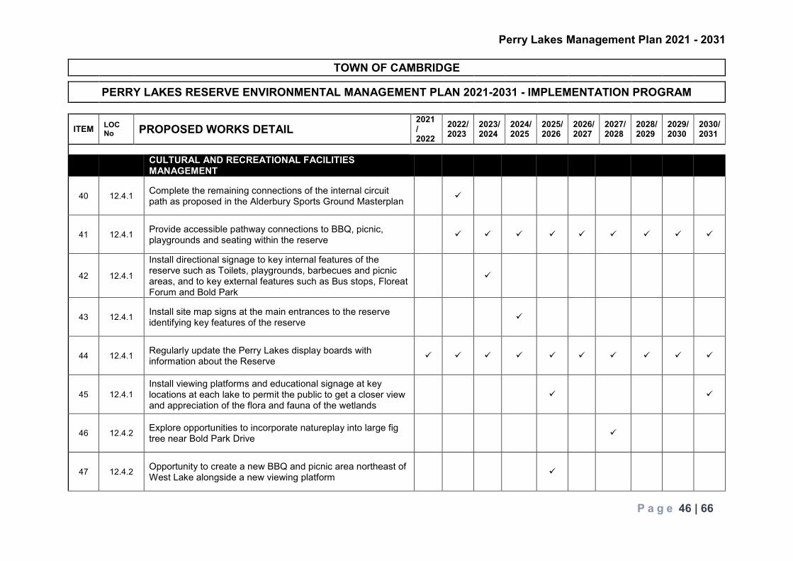
Perry Lakes Management Plan 2021 - 2031
P a g e 46 | 66
TOWN OF CAMBRIDGE
PERRY LAKES RESERVE ENVIRONMENTAL MANAGEMENT PLAN 2021-2031 - IMPLEMENTATION PROGRAM
ITEM LOC No PROPOSED WORKS DETAIL
2021/ 2022
2022/ 2023
2023/ 2024
2024/ 2025
2025/ 2026
2026/ 2027
2027/ 2028
2028/ 2029
2029/ 2030
2030/ 2031
CULTURAL AND RECREATIONAL FACILITIES
MANAGEMENT
40 12.4.1 Complete the remaining connections of the internal circuit path as proposed in the Alderbury Sports Ground Masterplan
41 12.4.1 Provide accessible pathway connections to BBQ, picnic, playgrounds and seating within the reserve
42 12.4.1
Install directional signage to key internal features of the reserve such as Toilets, playgrounds, barbecues and picnic areas, and to key external features such as Bus stops, Floreat Forum and Bold Park
43 12.4.1 Install site map signs at the main entrances to the reserve identifying key features of the reserve
44 12.4.1 Regularly update the Perry Lakes display boards with information about the Reserve
45 12.4.1 Install viewing platforms and educational signage at key locations at each lake to permit the public to get a closer view and appreciation of the flora and fauna of the wetlands
46 12.4.2 Explore opportunities to incorporate natureplay into large fig tree near Bold Park Drive
47 12.4.2 Opportunity to create a new BBQ and picnic area northeast of West Lake alongside a new viewing platform

Perry Lakes Management Plan 2021 - 2031
P a g e 47 | 66
48 12.4.2 Upgrade the playground south of West Lake to a regional facility, when at end of life.
49 12.4.2 Regularly monitor and maintain recreational infrastructure in accordance with Town of Cambridge asset management policy and procedures
50 12.4.2 Ensure adequate separation of recreational activities from other uses to avoid conflicts
51 12.4.2 Maintain the dog off-leash exercise area and continue to enforce dogs on-lead in all other areas
52 12.4.2 Continue to maintain sports fields in line with best management practices
53 12.4.2 Regularly monitor and maintain sport infrastructure including the skate park, basketball half-court and exercise equipment
54 12.4.2 Install new cricket nets as proposed in the Alderbury Sports Ground Masterplan
55 12.4.2 Line mark a running track with distance markers
56 12.4.2 Consider provisions for mobile food vans and al fresco dining facilities
57 12.4.3 Encourage the establishment of a Perry Lakes Friends Group
58 12.4.3 Promote events that connect the community with Perry Lakes and foster establishment of the Friends of Perry Lakes

Perry Lakes Management Plan 2021 - 2031
P a g e 48 | 66
59 12.4.3 Encourage schools to get involved with activities at the reserve which could be run in conjunction with the Perry Lakes Friends Group when established
60 12.4.4 Seek indigenous feedback for the Perry Lakes Management Plan prior to implementation of the plan’s recommended actions **
61 12.4.4 Consider an indigenous arts project at the Reserve **
62 12.4.4 Include information on Indigenous and European history in display boards and other signage around the Reserve **
Notes: - (**) - denotes projects that have implications under the Aboriginal Heritage Act 1972-1980
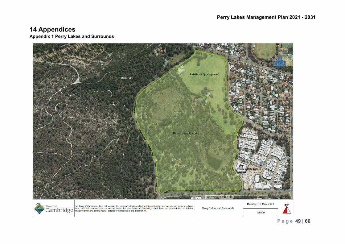
Perry Lakes Management Plan 2021 - 2031
P a g e 49 | 66
14 Appendices Appendix 1 Perry Lakes and Surrounds

Perry Lakes Management Plan 2021 - 2031
P a g e 50 | 66
Appendix 2 Perry Lakes Picnic Facilities

Perry Lakes Management Plan 2021 - 2031
P a g e 51 | 66
Appendix 3 Perry Lakes Seating and Tables

Perry Lakes Management Plan 2021 - 2031
P a g e 52 | 66
Appendix 4 Perry Lakes Playground and Exercise Facilities
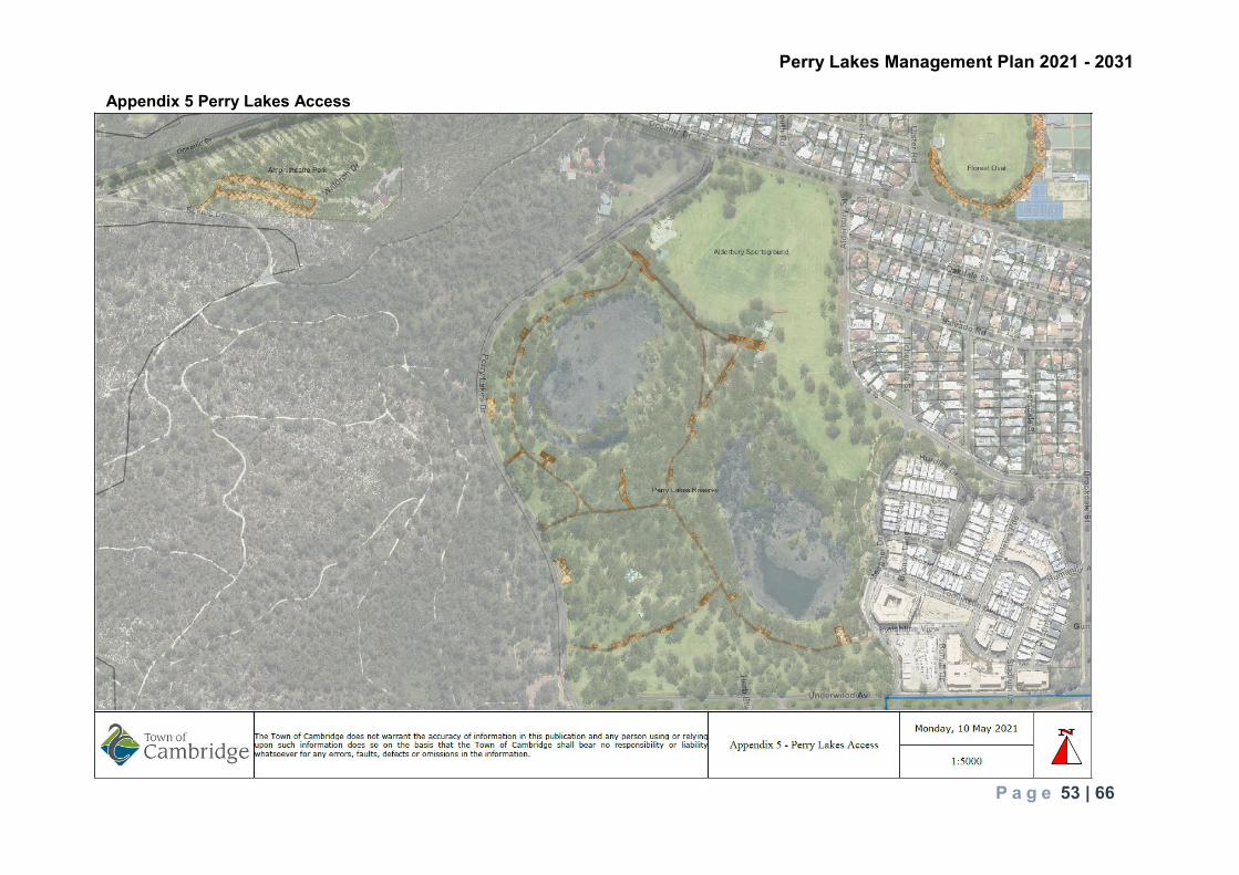
Perry Lakes Management Plan 2021 - 2031
P a g e 53 | 66
Appendix 5 Perry Lakes Access

Perry Lakes Management Plan 2021 - 2031
P a g e 54 | 66
Appendix 6 Perry Lakes Precinct Facilities

Perry Lakes Management Plan 2021 - 2031
P a g e 55 | 66
Appendix 7 Perry Lakes Zoning

Perry Lakes Management Plan 2021 - 2031
P a g e 56 | 66
Appendix 8 Legal Context Perry Lakes is managed within a statutory and policy framework. The applicable legislation, policies and guidelines are summarised in table 1 below. Table 1. Perry Lakes statutory and policy framework Legislation Policies and Guidelines Relevance
Commonwealth Environmental Protection and Biodiversity Conservation Act 1999
Threatened species guidelines and information sheets Migratory birds information
Matters of national environmental significant; Carnaby’s Cockatoo (Calyptorhynchus latirostris), Forest Red-tailed Black Cockatoo (Calyptorhynchus banksii naso), Australasian Bittern (Botaurus poiciloptilus) Tuart (Eucalyptus gomphocephala)
Western Australia Aboriginal Heritage Act 1972
Perry Lakes is not a registered site however it is listed as an ‘Other Heritage Place’ ID 3735 as a camp and hunting place. Regulation 10 and Section 18 permits from DPLH are not required
Biodiversity Conservation Act 2016
Protection of native flora and fauna Presence of declared rare fauna species Presence of priority 4 listed flora species
Biosecurity and Agriculture Management Act 2007
Declared Plant Control Handbook West Australian Organism List
Control of declared flora (weeds) and fauna organisms – Asparagus asparagoides is listed as a Declared Pest under the Act and Weeds of National Significance Off label permit use of herbicides
Bushfires Act 1954 Reducing the risk of bushfires addressing prevention, control and extinguishment of fires
Cat Act 2011 Creates statutory responsibilities for dog owners to register and control their cat/s. Implemented at a local level through local cat law
Responsibilities of local cat owners relating to registration and control and authority of council to trap and remove roaming cats

Perry Lakes Management Plan 2021 - 2031
P a g e 57 | 66
Conservation and Land Management Act 1984
Wetlands Conservation Policy for Western Australia 1997
Primary wetland conservation policy for Western Australia
Dog Act 1976 Creates statutory responsibilities for dog owners to register and control their dog/s. Implemented at a local level through local dog laws
Responsibilities of local dog owners relating to registration, control, on and off-leash exercise areas and the removal of faecal material
Environmental Protection Act 1986
Designated Conservation Category Wetlands Clearing of Native Vegetation Regulations EPA Position Statement no.4 Environmental Protection of Wetlands Bush Forever (State Planning Policy 2.8) Bushland Policy for the Perth Metropolitan Region.
Prevention of environmental harm Protection of wetlands listed in the Geomorphic Wetlands Swan Coastal Plain dataset including requirements relating to filling, effluent disposal and drainage management – proposed changes must be referred to the EPA for environmental impact assessment Native vegetation clearing requirements to be adhered to
Health Act 1911 Water quality within the lakes Litter Act 1979 Keep Australia Beautiful initiatives Reduction of litter in the environment Local Government Act 1995 Local Government responsibilities: duty of care and safety Planning Act 2005 Planning Policies
State Planning Policy 2 – Environment and Natural Resources Policy State Planning Policy 2.8 – Bushland Policy for the Perth Metropolitan Region Planning Guidelines Better Urban Water Management Acid Sulphate Soils (ASS) Bush Forever Fact Sheet
Zoning/land purpose Protection of natural values through appropriate planning Bush Forever listing and protection Protection of water resources and prevention of impacts to surface and groundwater Prevention of contamination during development activities from ASS
Local Government Perry Lakes Management Plan
Ongoing management of Perry Lakes
Town of Cambridge Urban Forest Strategy
Management of the Town’s urban forest to: Protect and enhance the urban forest

Perry Lakes Management Plan 2021 - 2031
P a g e 58 | 66
To foster public appreciation of the urban forest To ensure the resilience or the urban forest To improve connectivity of the urban forest
Town of Cambridge Sustainability Strategy
Incorporates protection of natural assets, fostering of green public realms and rehabilitation of natural areas
Town of Cambridge Local Planning Scheme No 1
Perry Lakes zoned ‘Parks and Recreation’ under the Metropolitan Region Scheme Protection of Bush Forever sites from clearing and development (Perry Lakes is part of Bush Forever Site- BF 312 which includes Bold Park)
WESROC Greening Plan 2002
Promotes regional ecological linkages through greening corridors
Animals Local Law Requirements of responsible dog ownership including control of dogs, removal of dog faeces and the provision of dog exercise areas where dogs may be off-leash Requirements of responsible cat ownership including effective control of cats
Town of Cambridge Dog Control Policy No 4.4.1
Provides for dog exercise areas (off-leash). All other areas are designated on-leash areas at all times Requirement that dogs must be under effective control at all times and that dog owners must pick up and remove their dog faeces
Your Dog and You pamphlet Responsibilities of dog owners Responsible Cat Ownership pamphlet Responsibilities of cat owners

Perry Lakes Management Plan 2021 - 2031
P a g e 59 | 66
Appendix 9 Perry Lakes Irrigation

Perry Lakes Management Plan 2021 - 2031
P a g e 60 | 66
Appendix 10 Vegetation Type

Perry Lakes Management Plan 2021 - 2031
P a g e 61 | 66
Appendix 11 Perry Lakes Flora Species Family Genus Species Common name Status Aizoaceae Carpobrotus edulis Hottentot Fig Aizoaceae Carpobrotus virescens Coastal Pigface Anacardiaceae Schinus terebinthifolia Brazillian Pepper * Araliaceae Hydrocotyle bonariensis Pennywort * Arecaceae Washingtonia filifera Cotton Palm * Asparagaceae Asparagus asparagoides Bridal Creeper * DP Asphodelaceae Trachyandra divaricata * Asteraceae Cirsium vulgare Spear Thistle * Asteraceae Conyza parva Asteraceae Hypochaeris sp. Catsear * Asteraceae Sonchus oleraceus Common Sowthistle * Asteraceae Symphyotrichum squamatum Bushy Starwort * Casuarinaceae Casuarina obesa Chenopodiaceae Rhagodia baccata Berry Saltbush Cyperaceae Baumea articulata Jointed Rush Cyperaceae Bolboschoenus caldwelli Marsh Club-rush Cyperaceae Cyperus congestus Dense Flat-sedge * Cyperaceae Cyperus polystachyos Bunch Sedge Cyperaceae Ficinia nodosa Knotted Club Rush Cyperaceae Lepidosperma gladiatum Coast Sword Sedge Cyperaceae Lepidosperma longitudinale Cyperaceae Schoenoplectus tabernaemontani Sharpleaf Rush Fabaceae Acacia longifolia * Fabaceae Acacia cyclops Coastal Wattle Fabaceae Acacia lasiocarpa Panjang Fabaceae Acacia rostellifera Summer-scented Wattle Fabaceae Lathyrus tingitanus Tangier Pea * Fabaceae Vicia sativa Common Vetch * Fumariaceae Fumaria capreolata Whiteflower Fumitory * Geraniaceae Pelargonium capitatum Rose Pelargonium * Goodeniaceae Scaevola crassifolia Thick-leaved Scavolea Hemerocallidaceae Dianella revoluta Blueberry Lily Juncaceae Juncus pallidus Pale Rush Malvaceae Brachychiton sp. * Malvaceae Malva sp. Marshmallow Plant * Meliaceae Melia azedarach White Cedar * Myrtaceae Agonis flexuosa WA Peppermint * Myrtaceae Calothamnus quadrifidus Kwowdjard Myrtaceae Calothamnus rupestris Mouse Ears Myrtaceae Corymbia calophylla Marri Myrtaceae Eucalyptus botryoides Swamp Mahogany *

Perry Lakes Management Plan 2021 - 2031
P a g e 62 | 66
Myrtaceae Eucalyptus camaldulensis Red River Gum * Myrtaceae Eucalyptus cladocalyx Sugar Gum * Myrtaceae Eucalyptus globulus Tasmanian Blue Gum * Myrtaceae Eucalyptus gomphocephala Tuart Myrtaceae Eucalyptus rudis Flooded Gum Myrtaceae Melaleuca armillaris Bracelet Honey Myrtle Myrtaceae Melaleuca linearifolia Snow in Summer * Myrtaceae Melaleuca citrina * Myrtaceae Melaleuca cuticularis Myrtaceae Melaleuca incana Grey Honeymyrtle Myrtaceae Melaleuca nesophila * Myrtaceae Melaleuca preissiana Stout Paperbark Myrtaceae Melaleuca quinquenervia Broadleaf Paperbark * Myrtaceae Melaleuca rhaphiophylla Swamp Paperbark Myrtaceae Melaleuca viminea subsp. viminea Oxalidaceae Oxalis pes-caprae Soursob * Pinaceae Pinus radiata Monterrey Pine * Poaceae Cenchrus clandestinus Kikuyu Grass * Poaceae Cynodon dactylon Couch * Poaceae Lagurus ovatus Hare's Tail Grass * Polygalaceae Acetosella vulgaris * Phytolaccaceae Phytolacca octandra Red Ink Plant * Salicaceae Salix sp. Willow * Solanaceae Solanum nigrum Black Berry Nightshade * Tropaeolaceae Tropaeolum majus Garden Nasturtium * Typhaceae Typha orientalis Bulrush Zamiaceae Macrozamia riedlei Zamia
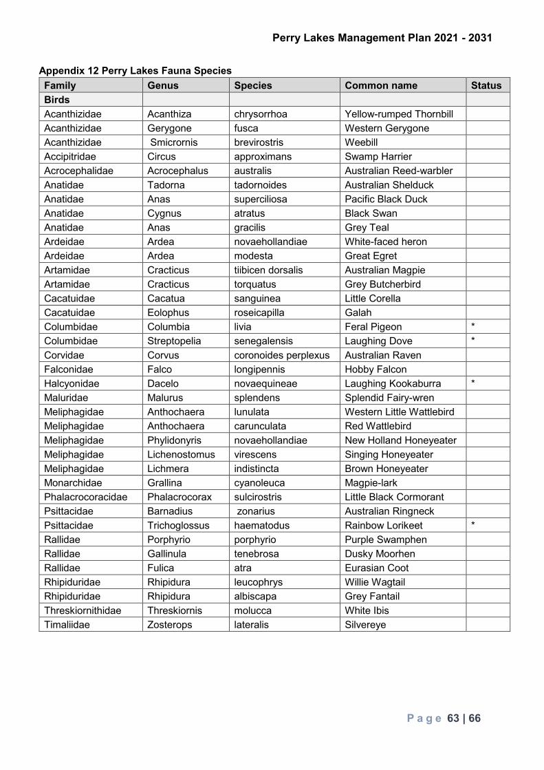
Perry Lakes Management Plan 2021 - 2031
P a g e 63 | 66
Appendix 12 Perry Lakes Fauna Species Family Genus Species Common name Status Birds Acanthizidae Acanthiza chrysorrhoa Yellow-rumped Thornbill Acanthizidae Gerygone fusca Western Gerygone Acanthizidae Smicrornis brevirostris Weebill Accipitridae Circus approximans Swamp Harrier Acrocephalidae Acrocephalus australis Australian Reed-warbler Anatidae Tadorna tadornoides Australian Shelduck Anatidae Anas superciliosa Pacific Black Duck Anatidae Cygnus atratus Black Swan Anatidae Anas gracilis Grey Teal Ardeidae Ardea novaehollandiae White-faced heron Ardeidae Ardea modesta Great Egret Artamidae Cracticus tiibicen dorsalis Australian Magpie Artamidae Cracticus torquatus Grey Butcherbird Cacatuidae Cacatua sanguinea Little Corella Cacatuidae Eolophus roseicapilla Galah Columbidae Columbia livia Feral Pigeon * Columbidae Streptopelia senegalensis Laughing Dove * Corvidae Corvus coronoides perplexus Australian Raven Falconidae Falco longipennis Hobby Falcon Halcyonidae Dacelo novaequineae Laughing Kookaburra * Maluridae Malurus splendens Splendid Fairy-wren Meliphagidae Anthochaera lunulata Western Little Wattlebird Meliphagidae Anthochaera carunculata Red Wattlebird Meliphagidae Phylidonyris novaehollandiae New Holland Honeyeater Meliphagidae Lichenostomus virescens Singing Honeyeater Meliphagidae Lichmera indistincta Brown Honeyeater Monarchidae Grallina cyanoleuca Magpie-lark Phalacrocoracidae Phalacrocorax sulcirostris Little Black Cormorant Psittacidae Barnadius zonarius Australian Ringneck Psittacidae Trichoglossus haematodus Rainbow Lorikeet * Rallidae Porphyrio porphyrio Purple Swamphen Rallidae Gallinula tenebrosa Dusky Moorhen Rallidae Fulica atra Eurasian Coot Rhipiduridae Rhipidura leucophrys Willie Wagtail Rhipiduridae Rhipidura albiscapa Grey Fantail Threskiornithidae Threskiornis molucca White Ibis Timaliidae Zosterops lateralis Silvereye

Perry Lakes Management Plan 2021 - 2031
P a g e 64 | 66
Mammals Canidae Canis domesticus Domestic Dog * Felidae Felis catus Cat * Amphibians Hylidae Litoria adelaidensis Slender Tree Frog Limnodynastidae Lymnodynastes dorsalis Western Banjo Frog Myobatrachidae Crinia insignifera Squelching Froglet Reptiles Cheluidae Chelodina colliei Oblong Turtle

Perry Lakes Management Plan 2021 - 2031
P a g e 65 | 66
Appendix 13 Vegetation Condition

Perry Lakes Management Plan 2021 - 2031
P a g e 66 | 66
15 References CSIRO (decreasing rainfall info for SW WA) https://www.csiro.au/en/Research/OandA/Areas/Assessing-our-climate/State-of-the-Climate-2020/Australias-changing-climate Department of Agriculture (increasing temperature info for SW WA) https://www.agric.wa.gov.au/climate-change/climate-trends-western-australia#:~:text=Western%20Australia's%20climate%20has%20changed,over%20the%20lower%20south%2Dwest. GHD - Perry Lakes Monitoring Flora and Fauna Baseline Assessment – September 2019 GHD - Perry Lakes Water and Sediment Monitoring – March 2021 Invertebrate Solutions Pty Ltd - Aquatic Macroinvertebrate baseline monitoring, Perry Lakes, Perth, Western Australia - November 2019