2017 2031 - membury village
TRANSCRIPT
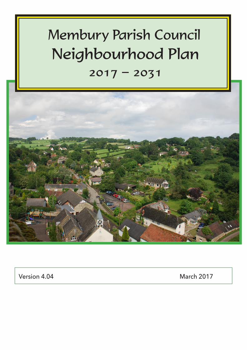
Membury Parish Council Neighbourhood Plan
2017 − 2031
Version 4.04 March 2017
2 Membury Neighbourhood Plan 4.04 − March 2017
CONTENTSOur Vision, Aims & Objectives Page 3Our Neighbourhood - where and what it is Page 4An overview of our Plan Page 5
Natural Environment [policies NE1 & 2] Page 7Policy NE1 Conserving & Enhancing the Natural Beauty of our parish Page 9Policy NE2 Preserving Tranquility & our Dark Skies Page 11
Built & Historic Environment [policies BHE 1 & 2] Page13Policy BHE1 Protecting our Valued Historical & Heritage Assets Page 15Policy BHE2 Maintaining the Built Character of our parish through high Quality Design Page 18
Housing & Population [policies HP 1 - 5] Page 20Policy HP1 Meeting new build within an evolving parish Page 25Policy HP2 Residential annexes Page 26Policy HP3 Meeting community housing needs Page 27Policy HP4 Conversion of existing buildings to housing or work/live units Page 28Policy HP5 Small scale self build housing Page 31
Community Facilities & Services [policies CFS 1-3] Page 33Policy CFS1 Changes to existing local community Facilities, amenities & assets Page 34Policy CFS2 Membury Primary Academy Page 34Policy CFS3 Loss of local community facilities, amenities & locally valued assets through redevelopment or change of use Page 35
Flooding [policy F1] Page 37Policy F1 New build, self build, conversion or extension Page 38
Transport and Access [policy TRA1] Page 40Policy TRA1 Rights of Way Page 40
Economy and Employment [policies EE1 - EE3] Page 42Policy EE1 Super-fast connectivity Page 43Policy EE2 Conversion of agricultural buildings Page 44Policy EE3 Farming (new development proposals) Page 46
Energy and Low Carbon [policies ELC1 & 2] Page 47Policy ELC1 Small-scale renewable & low carbon energy schemes Page 48Policy ELC2 Large scale renewable & low carbon energy schemes Page 48
appendices Page 511. Historical & Heritage Assets 512. Membury Design Statement and Supplementary Planning Guidance 53 − 583. Blackdown Hills AONB Design Guide for Houses 524. Membury Housing Specific Questionnaire 605. Definition of Local Families & Local Elderly 626. Membury and Rock Flooding history and data source 63
Parish Map Back cover
3Membury Neighbourhood Plan 4.04 − March 2017
Membury Neighbourhood Plan Vision, Aims and Objectives
Membury is a parish in east Devon on the Devon/Dorset/Somerset border [see page 4, Our Neighbourhood - What and Where it is for more specific details and back cover for parish map].
Our Vision for the parish represents our view of what we would like the parish to be like in the future by the time that the Plan reaches its end date in 2031. The Vision is a representation of the Aims of our Plan, the things we would like to achieve, which have been derived from local community consultation and other evidence.
Our Vision StatementTo maintain and enhance the unique character and sense of community within Membury parish whilst permitting small scale sustainable growth that is in line with the needs and wishes of the community.
Our AimsThe Aims of our Plan have been set following extensive community consultation and discussion. They are set out under a set of topic areas. These topics are:-
• Natural Environment• Built and Historic Environment• Housing and Population• Community Facilities and Services• Flooding• Transport and Access• Economy and Employment• Energy and Low Carbon
Our Objectives and PoliciesOur Objectives (how we are going to achieve the Aims) are set out in each topic section in the Plan. It is from these Objectives that our Policies specific to each topic have been developed.
Community Actions and ProjectsIt became apparent during our consultations that there were items and actions of significant interest to the community which were outside the scope or remit of a Neighbourhood Plan but should not be lost. These have been collated under a single numerical sequence as Community Actions and Projects [CA].
4 Membury Neighbourhood Plan 4.04 − March 2017
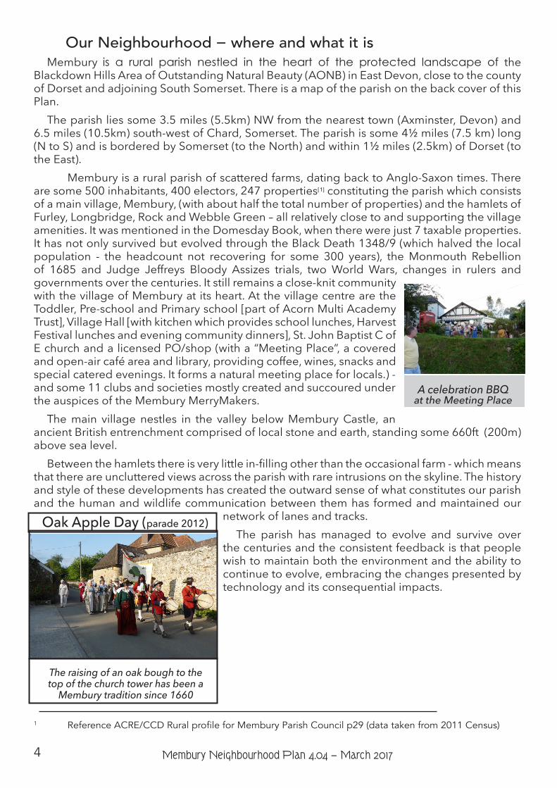
Our Neighbourhood − where and what it isMembury is a rural parish nestled in the heart of the protected landscape of the
Blackdown Hills Area of Outstanding Natural Beauty (AONB) in East Devon, close to the county of Dorset and adjoining South Somerset. There is a map of the parish on the back cover of this Plan.
The parish lies some 3.5 miles (5.5km) NW from the nearest town (Axminster, Devon) and 6.5 miles (10.5km) south-west of Chard, Somerset. The parish is some 4½ miles (7.5 km) long (N to S) and is bordered by Somerset (to the North) and within 1½ miles (2.5km) of Dorset (to the East).
Membury is a rural parish of scattered farms, dating back to Anglo-Saxon times. There are some 500 inhabitants, 400 electors, 247 properties[ 1] constituting the parish which consists of a main village, Membury, (with about half the total number of properties) and the hamlets of Furley, Longbridge, Rock and Webble Green – all relatively close to and supporting the village amenities. It was mentioned in the Domesday Book, when there were just 7 taxable properties. It has not only survived but evolved through the Black Death 1348/9 (which halved the local population - the headcount not recovering for some 300 years), the Monmouth Rebellion of 1685 and Judge Jeffreys Bloody Assizes trials, two World Wars, changes in rulers and governments over the centuries. It still remains a close-knit community with the village of Membury at its heart. At the village centre are the Toddler, Pre-school and Primary school [part of Acorn Multi Academy Trust], Village Hall [with kitchen which provides school lunches, Harvest Festival lunches and evening community dinners], St. John Baptist C of E church and a licensed PO/shop (with a “Meeting Place”, a covered and open-air café area and library, providing coffee, wines, snacks and special catered evenings. It forms a natural meeting place for locals.) - and some 11 clubs and societies mostly created and succoured under the auspices of the Membury MerryMakers.
The main village nestles in the valley below Membury Castle, an ancient British entrenchment comprised of local stone and earth, standing some 660ft (200m) above sea level.
Between the hamlets there is very little in-filling other than the occasional farm - which means that there are uncluttered views across the parish with rare intrusions on the skyline. The history and style of these developments has created the outward sense of what constitutes our parish and the human and wildlife communication between them has formed and maintained our
network of lanes and tracks.The parish has managed to evolve and survive over
the centuries and the consistent feedback is that people wish to maintain both the environment and the ability to continue to evolve, embracing the changes presented by technology and its consequential impacts.
1 Reference ACRE/CCD Rural profile for Membury Parish Council p29 (data taken from 2011 Census)
A celebration BBQat the Meeting Place
Oak Apple Day (parade 2012)
The raising of an oak bough to the top of the church tower has been a
Membury tradition since 1660
5Membury Neighbourhood Plan 4.04 − March 2017
An Overview of our PlanFeedback from our public consultations was consistent and overwhelming; there was a
desire to:-• protect the current views, natural environment, ecology, tranquillity and dark skies • control the siting, design and visual impact of new build and modifications to ensure that
it is sympathetic to the character of the area• allow the parish to continue to evolve through some level of new development and
provision of lower cost housing thus improving parish self-sufficiency and longevity• to prevent any new development, or an aggregation of new developments, to be larger
than 6 units in Membury village or 3 units in any named hamlet to avoid spoiling the existing character of the community
• control & reduce flood risks especially in Membury village and Rock hamletThere was a strong feeling that the parish was an entity which needed to be supported and
as such had created and wished to continue its own degree of sustainability. In particular there was a desire to measure the parish as a whole and not be broken down into micro-sections; hence hamlets were as important as the village in sustaining the school and church and shop and local entertainment and were not to be measured as stand-alone communities.
There was also considerable interest expressed in local heritage sites and their protection, local facilities, new employment, the network of lanes, tracks and footpaths and some response to low carbon energy schemes.
Our Plan has attempted to bring all these interests together in a cohesive and integrated manner.
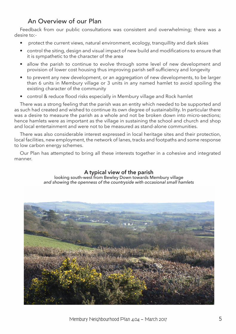
A typical view of the parish looking south-west from Bewley Down towards Membury village
and showing the openness of the countryside with occasional small hamlets
6 Membury Neighbourhood Plan 4.04 − March 2017
Natural EnvironmentFollowing extensive consultation with our community, we have agreed that the issues of most importance to us are those relating to our outstanding natural environment. Therefore, the Aims and Objectives that we have developed for our Plan relating to the natural environment and set out below are our priorities which should be given the highest consideration within the context of the other policies in this Plan.
Aims Objectives
1. Protect and enhance the natural environment, including the distinctive landscape and ecology.
1a) Conserve and enhance the existing beauty of the parish by encouraging the planting of native trees and hedges along with the preservation of the existing Devon banks.
2. Protect the tranquillity of the environment and maintain the dark skies.
2a) Resist any development or non-trunk road scheme likely to have an adverse effect on tranquillity or dark skies and seek ways to reduce any existing impact.
Introduction The parish is connected by a maze of narrow sunken lanes derived from original trackways
and consists, in the main, of a steeply undulating patchwork of fields with small hamlets of low density housing. Other than the occasional farmstead there is little development between hamlets. The lanes are usually single track with passing places, lined by Devon raised banks. The area is liberally spread with native trees, some stands and copses. Both domestic and agricultural boundaries are mainly stone walls, hedges and banks freely interspersed with indigenous/native trees. These boundaries form interlinking biodiverse corridors.
There is an extremely well supported range of clubs (badminton to bridge, pantomime to local history) meeting in the village hall and/or the Meeting Place.
These distinctive qualities of the parish are characteristics highly valued by the people who live here and is one of the reasons that we choose to do so. This applies both to those of us who have moved into the parish and those who have grown up here and stayed (or moved away for a time and then returned). The well documented characteristics and the value of our natural environment as an asset to people, wildlife and biodiversity has been supported by the responses to our Neighbourhood Plan local consultation and community questionnaire.
Retaining & Enhancing the Natural Beauty of our ParishBackground, Reasoning and Policy NE1We have already identified the importance of the high quality of the landscape and of
the biodiversity in the parish as part of that landscape, to both the people who live here and the wildlife which inhabits the natural environment. It is critical, therefore, that our natural environment is retained, conserved and enhanced where necessary now and in the future.
While there are other policies at national and district levels which afford some protection
7Membury Neighbourhood Plan 4.04 − March 2017
of our natural environment (see the related policies box below), there are a number of locally specific issues which we deem of sufficient importance to the community to require additional policy protection and guidance. At the present time there are two Sites of Special Scientific Interest (SSSI) [Furley Chalk Pit and Quarry Fields meadows] and other wildlife protected sites within the parish. We are also conscious that while the approved AONB Management Plan provides principles which should be applied to the natural environment in Membury, they do not have statutory weight in the decision making process even though they should be considered as a “material consideration” when planning proposals are considered by the local planning authority.
We feel a strong sense of need for our Plan to reinforce adequately some of the over-arching principles of protection for the environment to give us both the certainty that such policy coverage will remain and also to ensure that our Plan represents fully the weight of the issues raised by our community. In doing so it can fulfil its Aims and Objectives without relying solely on other policies set out elsewhere. Our Aims and Objectives, identified as important by the community, also show synergy with many of the agreed AONB Management Plan principles and policies.
We are clear that it is not the role of the Neighbourhood Plan to prevent development from taking place. However, we are equally clear that any development which is proposed within the parish, as part of the AONB, requires special consideration to ensure that its impact does not have adverse or negative impacts on our valued natural environment. We therefore require development proposals to demonstrate that they will not have any adverse impact on the existing state of the natural environment.
Our concern about potential adverse impact (and therefore our policy) extends to two specific issues, raised as particularly important by the community during consultation and supported by other evidence: a desire to see the existing countryside structure protected and promote the planting and re-stocking with native species; and the need to protect our traditional trees and ancient hedge banks and hedgerows.
Our preference is for appropriate development to be below the skyline and to be designed and located to fit within the landscape without having adverse impacts on its surroundings and the natural and built character of the area within which the proposal is located. In some cases, it may be acceptable for appropriate landscaping to play a role to ensure that there is no adverse impact on the setting of the proposal and where it will contribute to enhancing local character. Where the use of planting is considered to be an appropriate part of the proposal, native species of plants should be used.
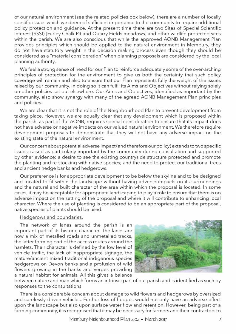
Hedgerows and boundaries.The network of lanes around the parish is an
important part of its historic character. The lanes are now a mix of metalled roads and unmetalled tracks, the latter forming part of the access routes around the hamlets. Their character is defined by the low level of vehicle traffic, the lack of inappropriate signage, the mature/ancient mixed traditional indigenous species hedgerows on Devon banks and a profusion of wild flowers growing in the banks and verges providing a natural habitat for animals. All this gives a balance between nature and man which forms an intrinsic part of our parish and is identified as such by responses to the consultations.
There is a considerable concern about damage to wild flowers and hedgerows by oversized and carelessly driven vehicles. Further loss of hedges would not only have an adverse effect upon the landscape but also upon surface water flow and retention. However, being part of a farming community, it is recognised that it may be necessary for farmers and their contractors to
8 Membury Neighbourhood Plan 4.04 − March 2017
use larger equipment to get greater efficiency, hence the occasional need to increase gateway sizes.
Devon hedges (commonly referred to as Devon Banks) are a common feature of the landscape in Membury parish. They are usually formed of an earth bank which is faced with either stone or turf and is often topped with bushes or shrubs often very old, biodiverse and very attractive. They play an important role as stock-proof barriers, shelters for livestock and crops, and encouraging growth of our native flora and fauna, in turn promoting habitat for insects, birds and wildlife growth. Our farming community and other local landowners have a key role in maintaining the integrity of these important features. The successful conservation of these hedges is critical to maintaining the special character of our natural, farmed and historic landscape.
The community values its footpaths and woodland as being of high importance to residents, with the majority also stating that Local Orchards and Trees require specific protection. Our landscape has the benefit of some specimen trees, stands and copses. We have a number of old, small orchards with mature trees that are particularly important because they provide both a link to our past and a variety of old fruit species that are no longer being planted. They, too, often provide regular favoured habitats and food for birds and animals and their continuity makes them particularly important.
9Membury Neighbourhood Plan 4.04 − March 2017
Policy NE1 - retaining and enhancing the natural beauty of our parish
1) Development proposals will only be supported where
a) they have demonstrated that any adverse impacts on the natural environment (landscape and biodiversity) have been satisfactorily mitigated, and
b) they enhance the natural environment where there is the opportunity to do so.
2) Where mitigating measures are unavoidably required for development to be acceptable within its landscape setting, appropriate landscaping should be employed that is compatible with the local landscape character. Such measures should include the use of native species of trees and hedges (e.g. any of the ancient fruit trees, native trees [oak, ash, beech, field maple and hazel] plus hawthorn, blackthorn, holly, juniper, wild privet, dog rose and wild cherry).
3) Proposals for development* which unavoidably affect traditional Devon hedges will only be supported where they have demonstrated that options have been assessed and, as a result, have proposed the least damaging option (to the hedgerow/bank, setting in the landscape, biodiversity and habitats).
4) There is a presumption of conservation of any existing natural features, i.e. orchards, trees, hedgerows, boundaries [even where they are not afforded specific protection by tree preservation orders or through being in a protected area (AONB), or as curtilage to a designated listed building] in any new development or redevelopment to both protect and enhance the existing character of the parish. Any removal must be justified in the planning application and new or replacements must be of traditional single or mixed species, e.g. any of the ancient fruit trees, native trees (oak, ash, beech, field maple and hazel) plus hawthorn and/or blackthorn, holly, juniper, wild privet, dog rose and wild cherry.
* For the avoidance of doubt, in this context, the definition of “development” includes changes to access to the highway where planning permission is required and in such cases the Devon County Council Highways Protocol for Protected Landscapes should be applied.
10 Membury Neighbourhood Plan 4.04 − March 2017
Preserving Tranquillity and Our Dark SkiesBackground, Reasoning and Policy NE2
We have already identified the importance of the tranquillity of our parish in relation to the characteristics of the natural environment and landscape. Much of the coverage in policy terms which relates to preserving the tranquillity of our environment is contained within AONB Management Plan guidance (which is advisory and not statutory). The adopted Local Plan has no policies specifically referencing or considering the implications of potential change to the tranquillity of our parish. National planning policy allows for planning policies and decisions to aim to identify and protect areas of tranquillity which “have remained relatively undisturbed by noise and are prized for their recreational and amenity value for this reason”.[ 2] It is a locally specific
issue to our parish and therefore, given its importance to the community, merits some reinforcement through policy in our Plan.
There is a significant body of evidence which demonstrates the presence of dark skies above the parish and their value. Protecting them as an asset through the control of light pollution is important locally. Even small changes to lighting can have an impact when added together cumulatively. National planning policy states that “By encouraging good design, planning policies and decisions
should limit the impact of light pollution from artificial light on local amenity, intrinsically dark landscapes and nature
conservation.”[ 3] The Local Plan sets out a policy which identifies light pollution as District-wide criteria for consideration of development proposals. The focus of this policy is on local amenity and surroundings rather than on the impact on dark skies per se. However, the AONB Management Plan sets out an objective which relates, very clearly, to the tranquillity and value stating that “The tranquillity of the Blackdown Hills AONB is conserved and enhanced by restricting or reducing noise and light pollution and major developments within or affecting the AONB.”[ 4]
Given this context, the importance to the community, and its identification in the AONB Management Plan objectives and policies as an important issue, we have introduced a policy which specifically refers to maintaining tranquillity and maintaining our dark skies through the control of light pollution. We have also introduced a community action to encourage the use of the AONB guidance to householders and organisations given that changing small scale lighting and adding household lighting fixtures is not normally subject to requirements for planning permission.
2 Paragraph 123, National Planning Policy Framework, Department for Communities and Local Government 3 Paragraph 125, National Planning Policy Framework, Department for Communities and Local Government. 4 p56, Objective PD5, Blackdown Hills Management Plan, Blackdown Hills AONB, 2013
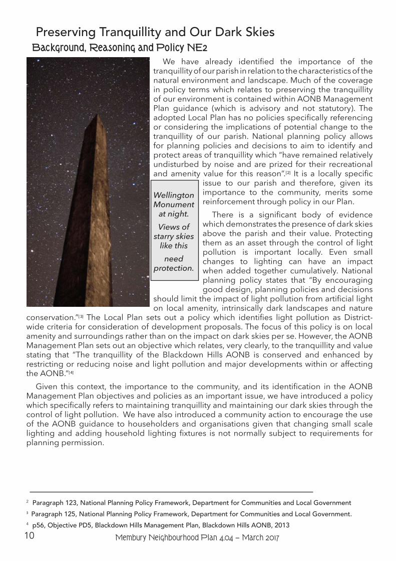
Wellington Monument
at night. Views of
starry skies like this
need protection.
11Membury Neighbourhood Plan 4.04 − March 2017
Community Actions and ProjectsCA1 - The Parish Council will work with partners including the local community,
farmers, the Blackdown Hills AONB and EDDC to encourage the planting of native species of hedge and trees.
CA2 - The Parish Council will work with partners including the local community, farmers, the Blackdown Hills AONB, Devon County Council and EDDC to encourage the positive management and preservation of our Devon banks.
CA3 - The Parish Council will work with the local community, farmers, the Blackdown Hills AONB, EDDC and DCC to identify particular hedgerows and Devon banks at risk in the parish.
CA4 - The Parish Council will actively resist attempts to introduce any extra unessential signs to the area.
CA5 - Vehicles used in the parish must be appropriate to their access routes to prevent damage to the lanes and track banks and hedges. When employing contractors it is the responsibility of the hirer to ensure suitably sized vehicles will be used to complete the contract.
CA6 - The Parish Council will work with the local community and DCC to retain and support the position of Footpath Warden.
CA7 - The Parish Council through the Parish Tree Warden with the assistance of others will prepare an asset register of trees, stands and copses which the community will help to protect.
CA8 - The Parish Council, through the Parish Tree Warden, will secure, encourage and promote a wide range of tree species, woods and hedges in and around the parish to enhance and benefit the community now and for the future.
CA9 - The Parish Tree Warden, through the auspices of the Parish Council, should form a group of residents who wish to assist in the preservation and appreciation of our tree and woodland heritage.
CA10 - The Parish Council through a Biodiversity Warden and with the assistance of others will prepare a biodiversity assessment of the parish.
CA11 - The Parish Council will encourage the use of guidance produced by the Blackdown Hills AONB for householders and organisations on limiting light pollution from new and replacement lighting.
CA12 - The Parish Council will continue the policy of no street lights.
Policy NE2 – Preserving Tranquillity and Our Dark SkiesTo ensure that the tranquillity of the parish and our dark skies are maintained,
development will only be supported where it demonstrates that it:
1) will have no adverse effect on the tranquillity of the parish through increasing levels and extent of noise;
2) will have no adverse effect, through light pollution (during any part of the year), on our valued dark skies observable from the parish.
12 Membury Neighbourhood Plan 4.04 − March 2017
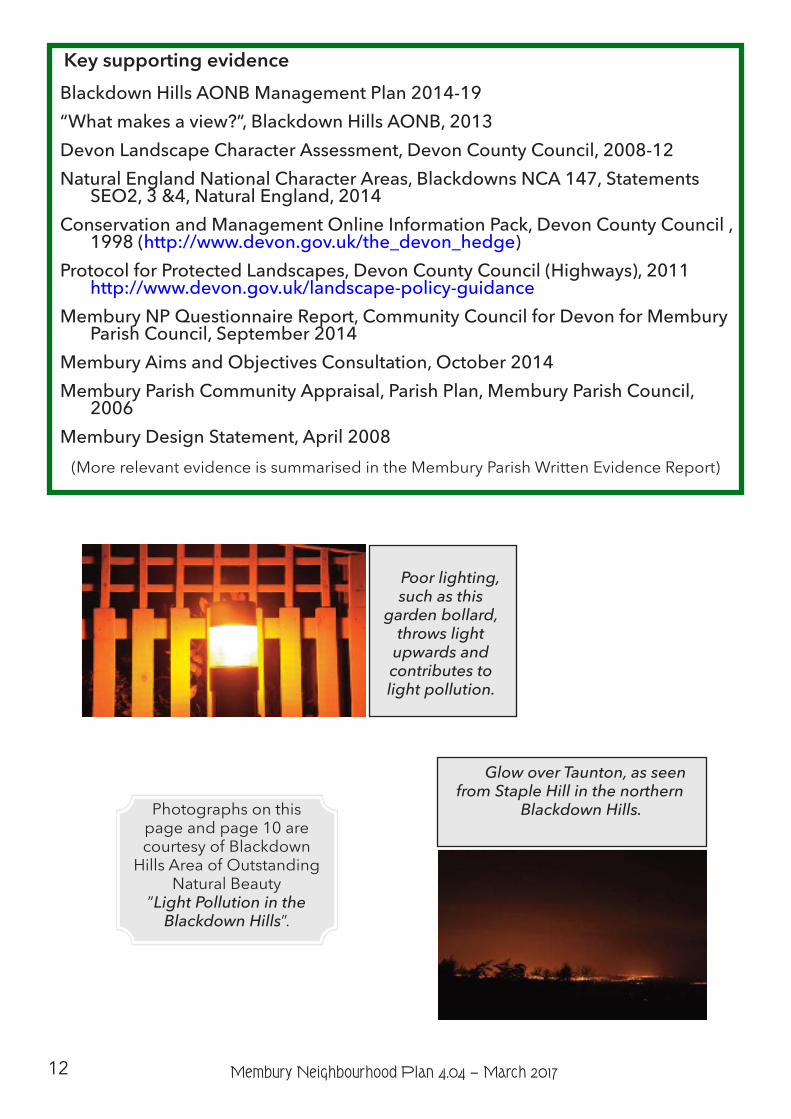
Key supporting evidence Blackdown Hills AONB Management Plan 2014-19 “What makes a view?”, Blackdown Hills AONB, 2013 Devon Landscape Character Assessment, Devon County Council, 2008-12 Natural England National Character Areas, Blackdowns NCA 147, Statements
SEO2, 3 &4, Natural England, 2014 Conservation and Management Online Information Pack, Devon County Council ,
1998 (http://www.devon.gov.uk/the_devon_hedge) Protocol for Protected Landscapes, Devon County Council (Highways), 2011
http://www.devon.gov.uk/landscape-policy-guidance Membury NP Questionnaire Report, Community Council for Devon for Membury
Parish Council, September 2014 Membury Aims and Objectives Consultation, October 2014 Membury Parish Community Appraisal, Parish Plan, Membury Parish Council,
2006 Membury Design Statement, April 2008
(More relevant evidence is summarised in the Membury Parish Written Evidence Report)
Poor lighting, such as this
garden bollard, throws light
upwards and contributes to light pollution.
Glow over Taunton, as seen from Staple Hill in the northern
Blackdown Hills.
Photographs on this page and page 10 are courtesy of Blackdown
Hills Area of Outstanding Natural Beauty
”Light Pollution in the Blackdown Hills”.
13Membury Neighbourhood Plan 4.04 − March 2017
Built and Historic Environment
Aims Objectives
3. Ensure that all new development is sympathetic to the traditional character of the area.
3a) Work with East Devon District Council and applicants to ensure that any new development, alteration or extension is carried out according to the Blackdown Hills AONB design guide for houses and the Membury Village Design Statement.
3b) Ensure that the size, scale, location and materials used for any development minimises its visual impact on the essential character of the AONB and neighbouring properties.
4. Protect the area’s heritage (sites and locations).
4a) Encourage the protection of Membury’s historical and archaeological sites [listed in Appendix 1]
4b) Retain the hamlets’ individuality
4c) Resist any unessential signage
4d) Encourage growth of native trees, flora and fauna
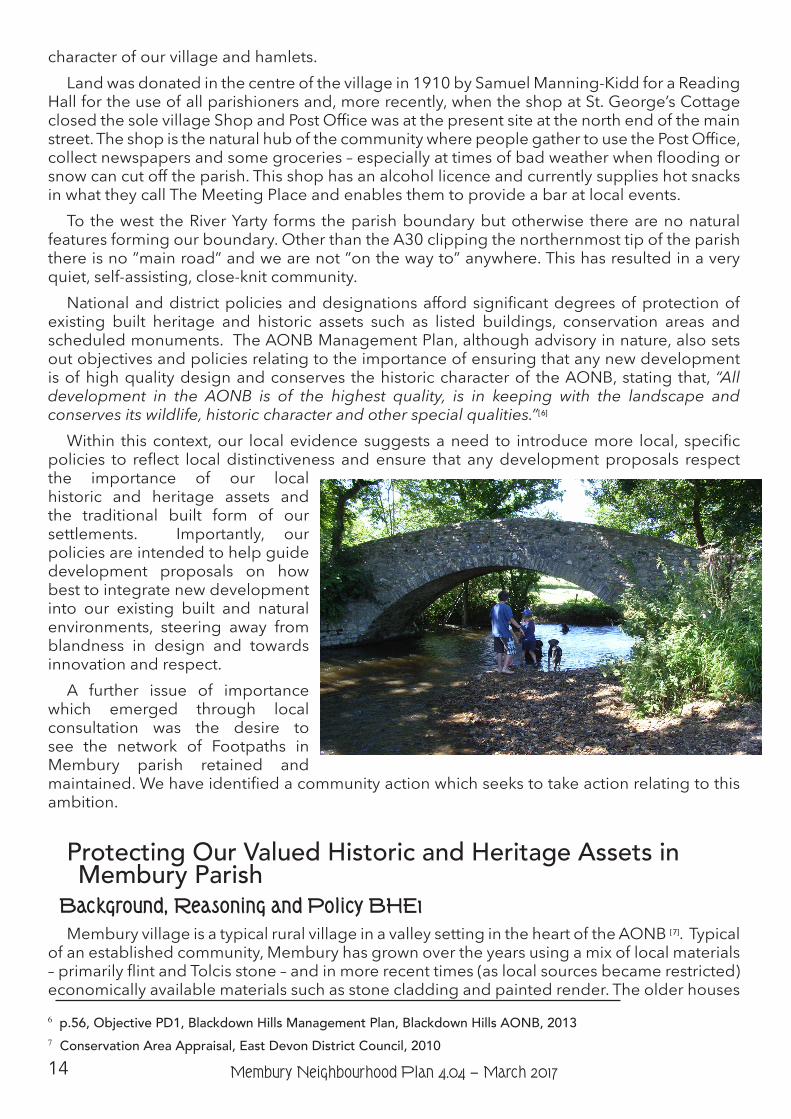
IntroductionOf the historical assets, Beckford Packhorse Bridge, Membury Court Chapel and Membury
Castle, the castle is the oldest. Through a natural habitation/work balance there has evolved a feel of general history (reflected in the enthusiasm of the Local History Society - one of eleven clubs and societies active in the parish). This feeling has been enhanced through the fabric of the church, St. John Baptist, incorporating work of every century from the twelfth to the twentieth and the village Primary School (circa 1841). There is also the Quaker burial ground on Goyle Acre Lane that the parish is responsible for maintaining.
Evidence from local consultation and our records of designated and important sites and buildings suggest that there are significant historic and heritage assets[ 5] with national designations and highly valued structures and buildings of local importance. The landscape setting of our village and hamlets is as important as the built form as it is the special landscape of the AONB which frames our settlements. These factors all come together to make up the
5 The National Planning Policy Framework defines a “heritage asset” as “A building, monument, site, place, area or landscape identified as having a degree of significance meriting consideration in planning decisions, because of its heritage interest. Heritage asset includes designated heritage assets and assets identified by the local planning authority (including local listing).” (Annex 2, p.52)
14 Membury Neighbourhood Plan 4.04 − March 2017
character of our village and hamlets.Land was donated in the centre of the village in 1910 by Samuel Manning-Kidd for a Reading
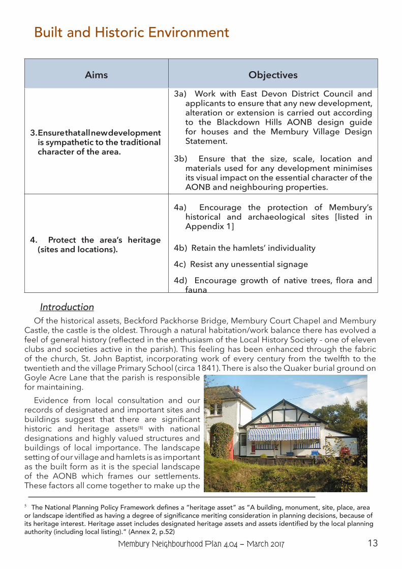
Hall for the use of all parishioners and, more recently, when the shop at St. George’s Cottage closed the sole village Shop and Post Office was at the present site at the north end of the main street. The shop is the natural hub of the community where people gather to use the Post Office, collect newspapers and some groceries – especially at times of bad weather when flooding or snow can cut off the parish. This shop has an alcohol licence and currently supplies hot snacks in what they call The Meeting Place and enables them to provide a bar at local events.
To the west the River Yarty forms the parish boundary but otherwise there are no natural features forming our boundary. Other than the A30 clipping the northernmost tip of the parish there is no ”main road” and we are not ”on the way to” anywhere. This has resulted in a very quiet, self-assisting, close-knit community.
National and district policies and designations afford significant degrees of protection of existing built heritage and historic assets such as listed buildings, conservation areas and scheduled monuments. The AONB Management Plan, although advisory in nature, also sets out objectives and policies relating to the importance of ensuring that any new development is of high quality design and conserves the historic character of the AONB, stating that, “All development in the AONB is of the highest quality, is in keeping with the landscape and conserves its wildlife, historic character and other special qualities.”[ 6]
Within this context, our local evidence suggests a need to introduce more local, specific policies to reflect local distinctiveness and ensure that any development proposals respect the importance of our local historic and heritage assets and the traditional built form of our settlements. Importantly, our policies are intended to help guide development proposals on how best to integrate new development into our existing built and natural environments, steering away from blandness in design and towards innovation and respect.
A further issue of importance which emerged through local consultation was the desire to see the network of Footpaths in Membury parish retained and maintained. We have identified a community action which seeks to take action relating to this ambition.
Protecting Our Valued Historic and Heritage Assets in Membury Parish
Background, Reasoning and Policy BHE1Membury village is a typical rural village in a valley setting in the heart of the AONB [ 7]. Typical
of an established community, Membury has grown over the years using a mix of local materials – primarily flint and Tolcis stone – and in more recent times (as local sources became restricted) economically available materials such as stone cladding and painted render. The older houses 6 p.56, Objective PD1, Blackdown Hills Management Plan, Blackdown Hills AONB, 2013 7 Conservation Area Appraisal, East Devon District Council, 2010
15Membury Neighbourhood Plan 4.04 − March 2017
tend to be of stone, originally thatched but now more likely to have slate or clay tiles with a chimney.
Across the rest of the parish there are numerous significant heritage and historic assets including listed buildings and scheduled monuments. The hill fort of Membury Castle is worth particular mention and has been identified as an asset worthy of attention and preservation.
In 2008, the Parish undertook an exercise to produce guidance on development- The Membury Village Design Statement (VDS) [ 8] which was afforded Supplementary Planning Guidance status by EDDC Planning Department. The provisions in this document still hold true and it is intended that any new development needs to work within those provisions.
8 Membury Design Statement, April 2008
Community Actions and ProjectsCA13 - The Parish Council will work with partners to encourage the protection
of historic assets and protect and enhance any other important heritage and historic buildings and archaeological sites.
CA14 - The Parish Council will work in partnership with Devon County Council as Highways Authority and other partners as necessary to ensure that there is no proliferation of signage.
Policy BHE1 – Protecting Our Valued Historic and Heritage Assets
Proposals for development will only be supported where they demonstrate in writing that they :-
1) have considered the impact of construction material deliveries to the lanes leading to and at the site and
2) will not have an adverse impact on nationally and locally designated and protected historic buildings and other valued archaeological, heritage and historic assets in the parish (such as Beckford Packhorse Bridge, Membury Court Chapel, Membury Castle, St. John Baptist church - see Appendix 1 for full list) and
3) have taken fully into account any additional supporting local evidence documenting local historic and heritage assets.
Main related national, district and AONB policiesNational Planning Policy Framework – Section 12National Planning Practice Guidance – Paragraph 007East Devon adopted Local Plan, 2006 – Policies EN8-11, Strategy 49East Devon new Local Plan (Proposed Submission Version 2012 as amended in
2013) – Policies EN1, EN9-12Blackdown Hills AONB Management Plan, 2014 -19– Policies PD 1/A, PD 1/B, PD
1/C, PD 2/A
16 Membury Neighbourhood Plan 4.04 − March 2017
Maintaining the Built Character of Our Parish through High Quality Design
Background, Reasoning and Policy BHE2Given the history of our village and hamlets and their setting in the AONB landscape, we
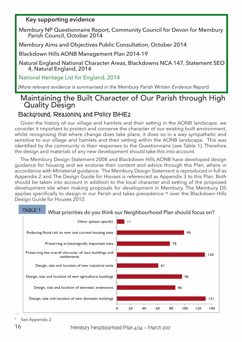
consider it important to protect and conserve the character of our existing built environment, whilst recognising that where change does take place, it does so in a way sympathetic and sensitive to our village and hamlets and their setting within the AONB landscape. This was identified by the community in their responses to the Questionnaire [see Table 1]. Therefore the design and materials of any new development should take this into account.
The Membury Design Statement 2008 and Blackdown Hills AONB have developed design guidance for housing and we endorse their content and advice through this Plan, where in accordance with Ministerial guidance. The Membury Design Statement is reproduced in full as Appendix 2 and The Design Guide for Houses is referenced as Appendix 3 to this Plan. Both should be taken into account in addition to the local character and setting of the proposed development site when making proposals for development in Membury. The Membury DS applies specifically to design in our Parish and takes precedence [ 9] over the Blackdown Hills Design Guide for Houses 2012.
9 See Appendix 2
What priorities do you think our Neighbourhood Plan should focus on?TABLE 1
Key supporting evidence Membury NP Questionnaire Report, Community Council for Devon for Membury
Parish Council, October 2014Membury Aims and Objectives Public Consultation, October 2014Blackdown Hills AONB Management Plan 2014-19Natural England National Character Areas, Blackdowns NCA 147, Statement SEO
4, Natural England, 2014National Heritage List for England, 2014
(More relevant evidence is summarised in the Membury Parish Written Evidence Report)
17Membury Neighbourhood Plan 4.04 − March 2017
The AONB guidance sets out a number of general design principles[ 10] which are:
• Whether new build or alterations, good detailing, appropriate materials and sensitive treatment of the spaces around buildings are essential elements in achieving a successful and sympathetic scheme.
• Locations for new buildings and development should follow the traditional settlement pattern and respect the integrity of historical settlement forms.
• Layouts for new development sites should reflect the road patterns and plot forms of the surrounding traditional settlement. It is important to create the same sense of enclosure, traditional proportions and massing of buildings, for example continuing a distinct building line along a street.
• Building forms and materials should reflect the local traditions.
• New extensions and additions to traditional buildings should respect the character and setting of the original building. Where new buildings are adjacent to traditional ones, consider the group as a whole, using scale, form, colour and materials to link new and old.
• Sensitive design of the spaces around buildings is essential to preserve local character. The most harmoniously designed building can look ‘out of place’ if it is not properly integrated into its setting.
• Contemporary design should draw on the qualities of landscape, historic features and buildings to reinforce local distinctiveness.
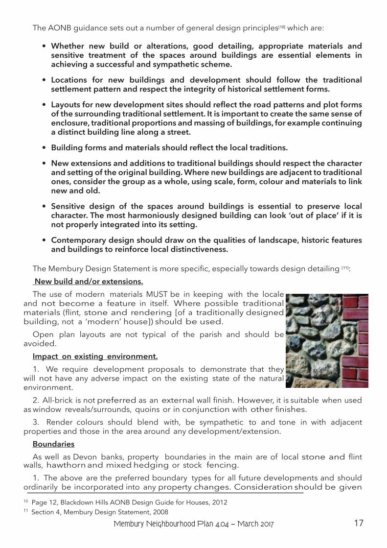
The Membury Design Statement is more specific, especially towards design detailing [ 11]: New build and/or extensions.The use of modern materials MUST be in keeping with the locale
and not become a feature in itself. Where possible traditional materials (flint, stone and rendering [of a traditionally designed building, not a ‘modern’ house]) should be used.
Open plan layouts are not typical of the parish and should be avoided.
Impact on existing environment.1. We require development proposals to demonstrate that they
will not have any adverse impact on the existing state of the natural environment.
2. All-brick is not preferred as an external wall finish. However, it is suitable when used as window reveals/surrounds, quoins or in conjunction with other finishes.
3. Render colours should blend with, be sympathetic to and tone in with adjacent properties and those in the area around any development/extension.
BoundariesAs well as Devon banks, property boundaries in the main are of local stone and flint
walls, hawthorn and mixed hedging or stock fencing.1. The above are the preferred boundary types for all future developments and should
ordinarily be incorporated into any property changes. Consideration should be given 10 Page 12, Blackdown Hills AONB Design Guide for Houses, 201211 Section 4, Membury Design Statement, 2008
18 Membury Neighbourhood Plan 4.04 − March 2017
to adjacent boundaries in finally deciding which is the most appropriate style for the new application.
2. Wooden panelling should be avoided particularly as front and visible side boundaries.3. Boundary walls greater than 2m in height should not be used between adjacent
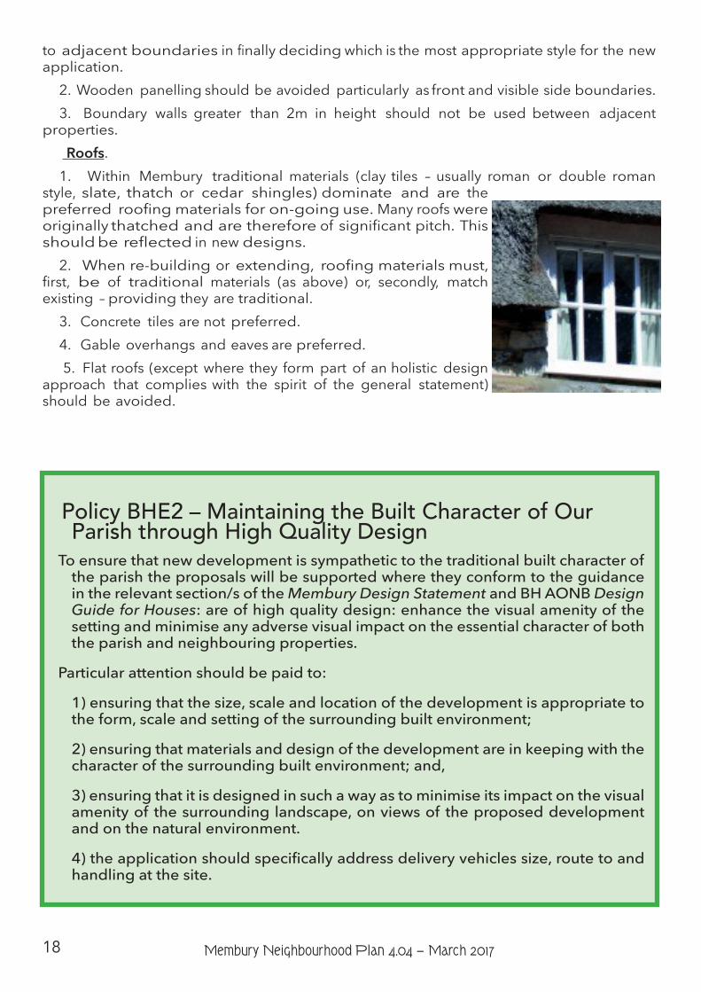
properties. Roofs.1. Within Membury traditional materials (clay tiles – usually roman or double roman
style, slate, thatch or cedar shingles) dominate and are the preferred roofing materials for on-going use. Many roofs were originally thatched and are therefore of significant pitch. This should be reflected in new designs.
2. When re-building or extending, roofing materials must, first, be of traditional materials (as above) or, secondly, match existing – providing they are traditional.
3. Concrete tiles are not preferred.4. Gable overhangs and eaves are preferred. 5. Flat roofs (except where they form part of an holistic design
approach that complies with the spirit of the general statement) should be avoided.
Policy BHE2 – Maintaining the Built Character of Our Parish through High Quality Design
To ensure that new development is sympathetic to the traditional built character of the parish the proposals will be supported where they conform to the guidance in the relevant section/s of the Membury Design Statement and BH AONB Design Guide for Houses: are of high quality design: enhance the visual amenity of the setting and minimise any adverse visual impact on the essential character of both the parish and neighbouring properties.
Particular attention should be paid to:
1) ensuring that the size, scale and location of the development is appropriate to the form, scale and setting of the surrounding built environment;
2) ensuring that materials and design of the development are in keeping with the character of the surrounding built environment; and,
3) ensuring that it is designed in such a way as to minimise its impact on the visual amenity of the surrounding landscape, on views of the proposed development and on the natural environment.
4) the application should specifically address delivery vehicles size, route to and handling at the site.
19Membury Neighbourhood Plan 4.04 − March 2017
Community Actions and ProjectsCA15 - The Parish Council will encourage use of the Blackdown Hills Area of
Outstanding Natural Beauty Design Guide for Houses and the Membury Village Design Statement for residential development which does not require planning permission or fall within Permitted Development Rights.
Key supporting evidenceBlackdown Hills AONB Management Plan 2014-19Design Guide for Houses, Blackdown Hills AONB“What makes a view?”, Blackdown Hills AONB, 2013Devon Landscape Character Assessment, Devon County Council, 2008-12Natural England National Character Areas, Blackdowns NCA 147, Statement
SEO2, Natural England, 2014Membury Village Design Statement, 2008
(More relevant evidence is summarised in the Membury Parish Written Evidence Report)
Main related national, district and AONB policiesNational Planning Policy Framework – Sections 7 and 12East Devon Local Plan 2013-2031 - Policies D1, EN1, EN9-12, H10, H11, S4, S5Blackdown Hills AONB Management Plan, 2014-19 - Policies PD 1/A, PD 1/B, PD
1/C, PD 2/A
20 Membury Neighbourhood Plan 4.04 − March 2017
Housing and PopulationAim Objectives
5. Support new small-scale local housing development which respects the characteristics and constraints of Membury’s built and natural environment yet allows continual evolution of the parish.
5a) Recognise the existing built form and boundaries of our hamlets and village and resist any new housing development outside these confines.
5b) Look favourably upon new housing development which meets parish needs and/or supports the ageing population as well as young families.
5c) Support development where it re-uses redundant or disused sites or buildings which meets the criteria of this Plan and would lead to an enhancement of the setting.
5d) Support schemes which will benefit the parish rural economy and/or society and improve the sustainability of the parish providing they are appropriate to the setting and meet the requirements of this Plan.
IntroductionMembury lies within the Blackdown Hills AONB (see Page 4). Roads to the village are narrow,
often single width country lanes, many of which are flanked by traditional Devon banks or hedges. There is no public transport available and anyone without a car would be reliant on lifts from others and/or community transport to get to services and facilities not available in the parish; therefore it is unlikely that anyone moves to the parish without their own transport or access to private transport.
In recent years, in Planning terms, the village has had two Built Up Area Boundaries [BUAB] which existed until the submission of the revised Local Plan in August 2015. These BUAB’s have been removed and the parish is designated as ”Open Countryside”. As stipulated in the Local Plan Strategy 7−Development in the Countryside[ 12], this Neighbourhood Plan seeks to modify this status by recognising the impact that the hamlets have in supporting the parish as a whole. In turn this is in accordance with recent government PPG advice ”all settlements can play a role in delivering sustainable development in rural areas”.
The Parish was recognised as a Neighbourhood and began to prepare this Neighbourhood Plan in 2014. As a result of local public consultations, two questionnaires (sent to each household in the parish, one of which specifically addressed new housing development), a Housing Needs Survey conducted by the Community Council of Devon, exhibitions and open public discussions the response has consistently been that the parishioners want to see the parish continue to evolve with a small amount of new house build. Further, feedback shows that this development should be spread across the whole parish (subject to design and location 12 East Devon Local Plan adopted January 2016
21Membury Neighbourhood Plan 4.04 − March 2017
restraints) to improve the viability of the whole parish and to avoid exacerbating the flood risk which would result from concentrating development in the village. It is a requirement that this evolution will enhance the ancient and vibrant community spirit, structure, form and environment.
The parish wishes to embody fully the aims and ideals of the NPPF as expressed by the Minister. This Neighbourhood Plan is an attempt to allow the parish to maintain its current status and vibrancy in an ever-changing world by using new technology to increase employment [ 13]: by preserving the countryside: by controlling the design and location of new build and by supporting the on-going sustainability of the parish as a whole.
It is a requirement of the NPPF that our Neighbourhood Plan, through the planning system, should contribute to achievement of sustainable development and perform a function in promoting this[ 14]. As a result of government funded infrastructure investment, the introduction of fibre optic telephone cable to the village cabinet (FTTC) and around the parish has improved the communications for some and assisted the efficiency and capability of businesses working from home within the hamlets located in the parish, especially valued by those multi-national businesses. There was also strong feedback that mobile phone signal - at the best patchy and often unobtainable - should be addressed. Other than the siting of masts, this is outside the scope of a Neighbourhood Plan but has been included within the Community Actions.
In recent years the development and improvement of the local parish education: the 2015 Ofsted rating of ”good with outstanding features” for the Primary school: the establishment of both Mother & Toddler group and Pre-School providing a linked feeder stream to the main school and the formation of the Acorn Multi Academy Trust. This has provided an excellent educational basis for the parish and has provided a significant increase in pupil head count. A knock-on effect has been a further support to working from home, thus enhancing the above average level of employment “working from home” and its environmental benefits[11].
Government statistics show that rural areas account for 16% of England’s total output.This Plan is intended to offset the possibility of an ageing parish population by capitalising
upon the aforementioned advantages and allowing modest development (unlikely to exceed an average of one new dwelling per year over the life of our Plan), encouraging the influx of younger families and supporting in a controlled way the national trend of relocation from urban to rural areas. It supports government rural policy “we want better internet and mobile phone communications, better transport, better schools, better skills, better housing, better business growth.”[ 15] Of these 7 aims Membury has already begun to tackle 4 and the public feedback wishes the Neighbourhood Plan to tackle a fifth - housing.
Recognise the existing built form and boundaries of our hamlets and village and resist any new housing development outside these confines.
Background, Reasoning and Policy HP1The Housing Needs Survey and Neighbourhood Plan Consultation responses evidence a
desire to see conversions, some new build and both a need and a desire for affordable housing for young families and suitable accommodation (possibly sheltered) for our older residents, albeit in small numbers. These should be the focus of any new development. In addition, the idea of barn and outbuilding conversion to new dwellings or work/live units was also broadly welcomed.13 Membury Parish Neighbourhood Plan Questionnaire, Community Council of Devon Oct. 2014 (Fig 19) which showed 57% of working age people already worked from home and a further 13% considered it. 14 Ref: Achieving sustainable development: paragraphs 6 & 7, NPPF15 Ref: Chancellor of the Exchequer, August 2015
22 Membury Neighbourhood Plan 4.04 − March 2017
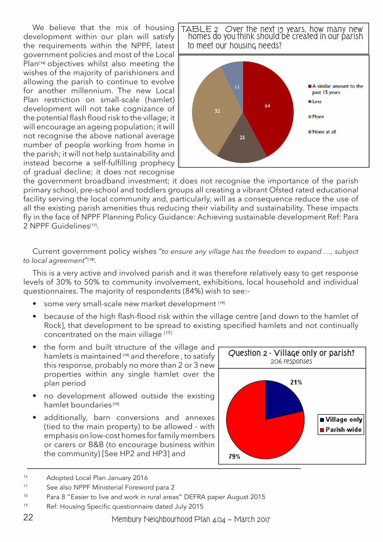
We believe that the mix of housing development within our plan will satisfy the requirements within the NPPF, latest government policies and most of the Local Plan[ 16] objectives whilst also meeting the wishes of the majority of parishioners and allowing the parish to continue to evolve for another millennium. The new Local Plan restriction on small-scale (hamlet) development will not take cognizance of the potential flash flood risk to the village; it will encourage an ageing population; it will not recognise the above national average number of people working from home in the parish; it will not help sustainability and instead become a self-fulfilling prophecy of gradual decline; it does not recognise the government broadband investment; it does not recognise the importance of the parish primary school, pre-school and toddlers groups all creating a vibrant Ofsted rated educational facility serving the local community and, particularly, will as a consequence reduce the use of all the existing parish amenities thus reducing their viability and sustainability. These impacts fly in the face of NPPF Planning Policy Guidance: Achieving sustainable development Ref: Para 2 NPPF Guidelines[ 17].
Current government policy wishes “to ensure any village has the freedom to expand …, subject to local agreement”[ 18].
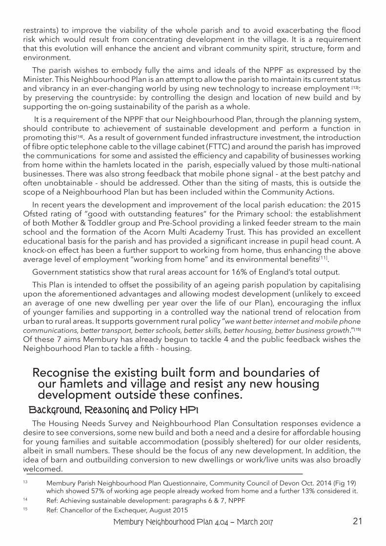
This is a very active and involved parish and it was therefore relatively easy to get response levels of 30% to 50% to community involvement, exhibitions, local household and individual questionnaires. The majority of respondents (84%) wish to see:-• some very small-scale new market development [ 19]
• because of the high flash-flood risk within the village centre [and down to the hamlet of Rock], that development to be spread to existing specified hamlets and not continually concentrated on the main village [19]
• the form and built structure of the village and hamlets is maintained [19] and therefore , to satisfy this response, probably no more than 2 or 3 new properties within any single hamlet over the plan period
• no development allowed outside the existing hamlet boundaries [19]
• additionally, barn conversions and annexes (tied to the main property) to be allowed - with emphasis on low-cost homes for family members or carers or B&B (to encourage business within the community) [See HP2 and HP3] and
16 Adopted Local Plan January 201617 See also NPPF Ministerial Foreword para 218 Para 8 ”Easier to live and work in rural areas” DEFRA paper August 201519 Ref: Housing Specific questionnaire dated July 2015
TABLE 2 Over the next 15 years, how many new homes do you think should be created in our parish to meet our housing needs?
Question 2 - Village only or parish?206 responses
23Membury Neighbourhood Plan 4.04 − March 2017
• a Community Land Trust to be established to accommodate older supported parishioners and low-cost housing for local people - also providing local employment for local people [See HP4].
International and national bodies have set out broad principles of sustainable development. Resolution 42/187 of the United Nations General Assembly defined sustainable development as: meeting the needs of the present without compromising the ability of future generations to meet their own needs. The UK Sustainable Development Strategy, ”Securing the Future” sets out five ‘guiding principles’ of sustainable development: living within the planet’s environmental limits; ensuring a strong, healthy and just society; achieving a sustainable economy; promoting good governance; and using sound science responsibly. It is the contention of the parish that we are meeting all these guidelines for current and future sustainability of the parish as a whole by permitting a very small amount of new development within the supporting named hamlets, thus allowing an ancient parish to continue to evolve and remain active and robust in an ever-changing environment.
National planning policy advises that it is important to recognise the particular issues facing rural areas in terms of housing supply and affordability and the role of housing in supporting the broader sustainability and vitality of villages and smaller settlements. It suggests that a thriving rural community in a living, working countryside depends, in part, upon retaining local services and community facilities such as schools, local shops, cultural venues, public houses and places of worship and that rural housing is essential to ensure viable use of these local facilities. It also states that assessing housing need and allocating sites should be considered at a strategic level and through the Local Plan and/or Neighbourhood Plan process. A Housing Needs Assessment[ 20] has been undertaken to discern ‘Affordable’ requirements in the parish. It is indicative of other housing requirements and the community’s appetite for that development.
Current adopted local planning policy requires special care to be taken when development takes place within the AONB, as do AONB policies, and the new Local Plan takes a similar stance as set out in earlier sections of this Plan, with development proposals being required to conserve or enhance the character of the landscape and protect the traditional local built form.
The Rt. Hon Greg Clark MP, in his Ministerial Introduction to NPPF said:-”The purpose of planning is to help achieve sustainable development.””Sustainable means ensuring that better lives for ourselves don’t mean worse lives for future
generations.””Development means growth. We must accommodate the new ways by which we will earn
our living in a competitive world. We must house a rising population, which is living longer and wants to make new choices. We must respond to the changes that new technologies offer us. Our lives, and the places in which we live them, can be better, but they will certainly be worse if things stagnate.”
Membury village is the main settlement in the parish with the hamlets of Furley, Longbridge, Rock and Webble Green; clusters at Crawley, Ford, Greendown, James Lane and Lewsley Lane and dispersed rural dwellings and farmsteads making up the remainder. The parish comprises [ 21] 190 detached houses, 37 semi-detached houses, 12 terraced houses and 8 non-purpose built flats, with no caravans/temporary accommodation units. Of these, 182 are owner-occupied
20 Housing Needs Survey Oct 2014 by Community Council of Devon for Membury Parish Council21 ACRE/CCD Rural profile for Membury Parish Oct. 2013
Question 1 - Numbers of new housing units231 respondents
24 Membury Neighbourhood Plan 4.04 − March 2017
with 24 of the remainder private rented and 15 either social rented or other rented accommodation. In the last 15 years, records suggest that 8 new dwellings have been built in the parish - approximately twice the rate over the last 900 years, ignoring the impact of the Black Death in 1348 which halved our population. This is not a high growth area and opinion does not wish that to change significantly. We have stipulated a guide number for new development over our plan period to avoid misunderstanding by developers.
The affordability ratio[ 22] in the parish is 18.1 (with the England average being 15.4) [ 23]. There are 27 properties in tax bands A & B (10.9% c.f. 22% for England average) whereas the number of properties in bands D, E, F & G are above England average. 18.6% of the parish population is aged 17 or under with 37% of the population in the 30 – 59 age group and 28.6% over 64 [ 24] - resulting in a dependency ratio [non-working to working age population] of 0.82 (cf England 0.55).
The Parish Council responded to a District Council consultation on potential housing sites in 2012 with a preference for a small site (if sensitively developed) which is within the envelope of the village over one further away from the centre of the village [ 25]. Since that time there has been a shift in public opinion, reflected in this Neighbourhood Plan and the recent Parish Council responses to the then emerging Local Plan.
22 Ref Membury Parish Neighbourhood Plan Questionnaire by Community Council of Devon dated October 201423 Data taken from the Membury Rural Community Profile, ACRE /CCD, 2013 (original data sourced from ONS 2011 census). The Profile states that “The housing affordability ratio is based on comparing house prices to earnings. Rather than compare average house prices and incomes, we have compared the “lowest quartile” (the lowest 25%) of prices to the lowest quartile of household incomes – which is more representative of groups trying to get onto the housing ladder. An affordability index of 10 would mean that lowest quartile house prices are 10 times as high as lowest quartile incomes. This data is only available for the local authority, not the local area.”24 Data taken from the Membury Rural Community Profile, October 2013 25 Membury Parish Council SHLAA Sites 2012 & Questionnaire, June 2014
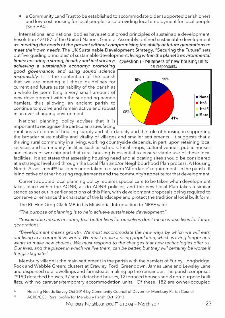
TABLE 3 Over the next fifteen years, which of the following types of housing do you think would be most appropriate in our parish? Nine people skipped this question, 150 responded.
25Membury Neighbourhood Plan 4.04 − March 2017
The results from our public consultation and Questionnaire [ 26] indicated that most people wished to see some level of new development - see Table 2 (page 22) and Table 3 - and we have reflected this in our Objectives.
Our Housing Specific Questionnaire addressed the deviation that parish feedback had expressed compared to recent Planning decisions and the newly adopted Local Plan - in restricting all development to ”large villages”. There were 243 responses (48.6% of parishioners) with 198 responses to Question 2 (39.6%), the parishioners re-iterated their desire to allow parish-wide new development - in accordance with Strategy 7 of the Local Plan.
Many people are self-employed (97 or 26.6% c.f. England average 9.8%) with six times the England average working from home[ 27]. This figure is likely to increase with the advent of a local fibre optic network improving electronic communication. There is a limited number of employers in the parish and much of the employment is naturally tied to agriculture and associated activity. It is also important to understand the geographical characteristics of Membury village and Rock as they inform the suitability or not of locating new development there, to what scale and of what type. [See also Flooding section.]
26 Membury Consultation Report , Community Council of Devon, October 2014 27 Data taken from the Membury Rural Community Profile, October 2013
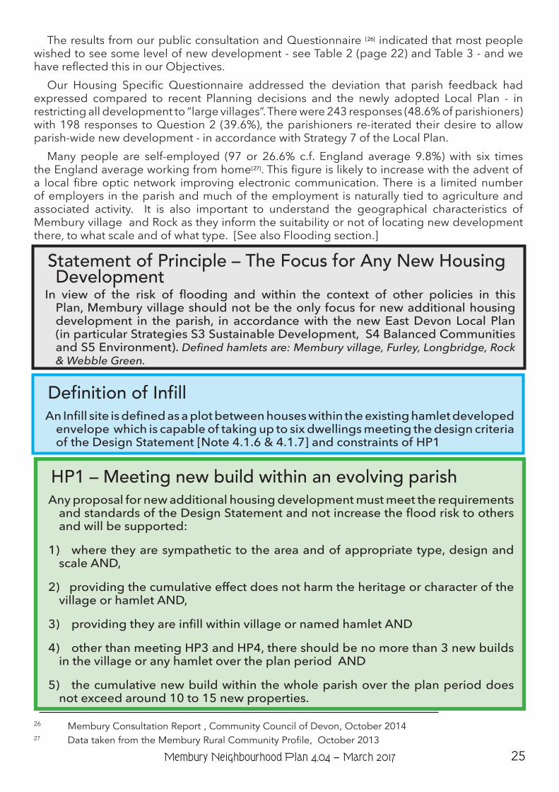
Statement of Principle – The Focus for Any New Housing Development
In view of the risk of flooding and within the context of other policies in this Plan, Membury village should not be the only focus for new additional housing development in the parish, in accordance with the new East Devon Local Plan (in particular Strategies S3 Sustainable Development, S4 Balanced Communities and S5 Environment). Defined hamlets are: Membury village, Furley, Longbridge, Rock & Webble Green.
HP1 – Meeting new build within an evolving parishAny proposal for new additional housing development must meet the requirements
and standards of the Design Statement and not increase the flood risk to others and will be supported:
1) where they are sympathetic to the area and of appropriate type, design and scale AND,
2) providing the cumulative effect does not harm the heritage or character of the village or hamlet AND,
3) providing they are infill within village or named hamlet AND
4) other than meeting HP3 and HP4, there should be no more than 3 new builds in the village or any hamlet over the plan period AND
5) the cumulative new build within the whole parish over the plan period does not exceed around 10 to 15 new properties.
Definition of InfillAn Infill site is defined as a plot between houses within the existing hamlet developed
envelope which is capable of taking up to six dwellings meeting the design criteria of the Design Statement [Note 4.1.6 & 4.1.7] and constraints of HP1
26 Membury Neighbourhood Plan 4.04 − March 2017
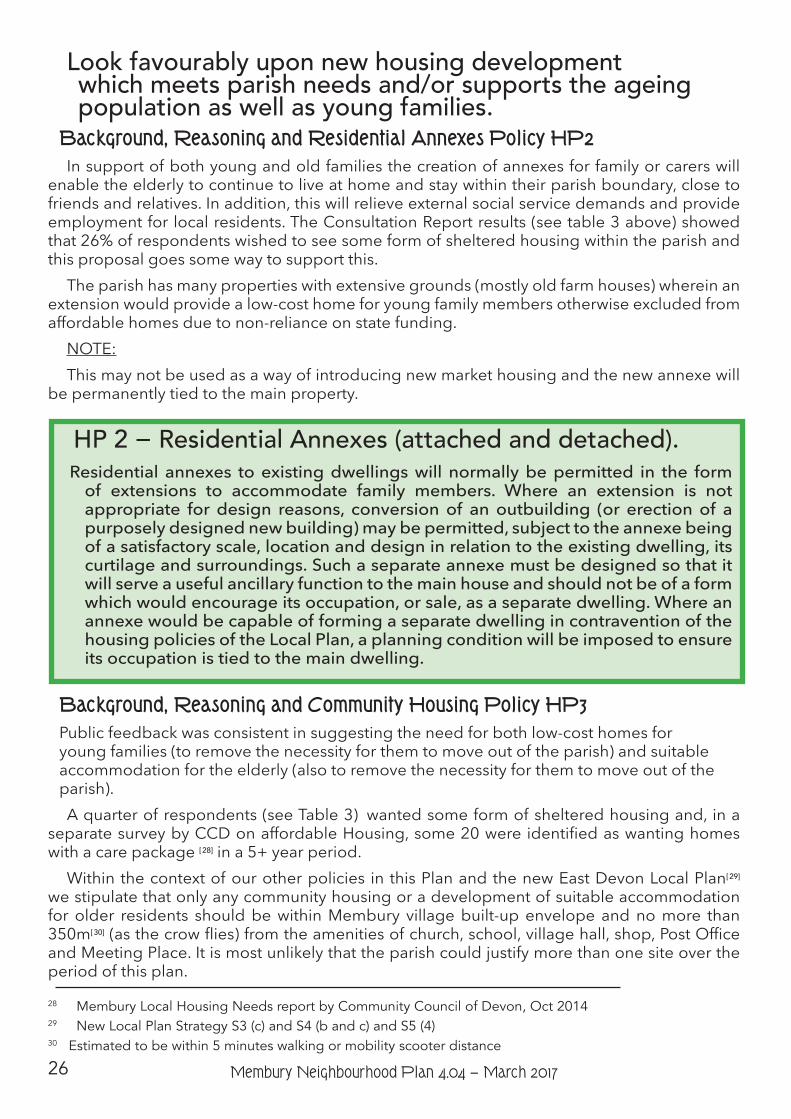
Look favourably upon new housing development which meets parish needs and/or supports the ageing population as well as young families.
Background, Reasoning and Residential Annexes Policy HP2In support of both young and old families the creation of annexes for family or carers will
enable the elderly to continue to live at home and stay within their parish boundary, close to friends and relatives. In addition, this will relieve external social service demands and provide employment for local residents. The Consultation Report results (see table 3 above) showed that 26% of respondents wished to see some form of sheltered housing within the parish and this proposal goes some way to support this.
The parish has many properties with extensive grounds (mostly old farm houses) wherein an extension would provide a low-cost home for young family members otherwise excluded from affordable homes due to non-reliance on state funding.
NOTE:This may not be used as a way of introducing new market housing and the new annexe will
be permanently tied to the main property.
Background, Reasoning and Community Housing Policy HP3Public feedback was consistent in suggesting the need for both low-cost homes for young families (to remove the necessity for them to move out of the parish) and suitable accommodation for the elderly (also to remove the necessity for them to move out of the parish).A quarter of respondents (see Table 3) wanted some form of sheltered housing and, in a
separate survey by CCD on affordable Housing, some 20 were identified as wanting homes with a care package [ 28] in a 5+ year period.
Within the context of our other policies in this Plan and the new East Devon Local Plan[ 29]
we stipulate that only any community housing or a development of suitable accommodation for older residents should be within Membury village built-up envelope and no more than 350m[ 30] (as the crow flies) from the amenities of church, school, village hall, shop, Post Office and Meeting Place. It is most unlikely that the parish could justify more than one site over the period of this plan.
28 Membury Local Housing Needs report by Community Council of Devon, Oct 2014 29 New Local Plan Strategy S3 (c) and S4 (b and c) and S5 (4)30 Estimated to be within 5 minutes walking or mobility scooter distance
HP 2 − Residential Annexes (attached and detached).Residential annexes to existing dwellings will normally be permitted in the form
of extensions to accommodate family members. Where an extension is not appropriate for design reasons, conversion of an outbuilding (or erection of a purposely designed new building) may be permitted, subject to the annexe being of a satisfactory scale, location and design in relation to the existing dwelling, its curtilage and surroundings. Such a separate annexe must be designed so that it will serve a useful ancillary function to the main house and should not be of a form which would encourage its occupation, or sale, as a separate dwelling. Where an annexe would be capable of forming a separate dwelling in contravention of the housing policies of the Local Plan, a planning condition will be imposed to ensure its occupation is tied to the main dwelling.
27Membury Neighbourhood Plan 4.04 − March 2017
National planning policy guidance[ 31] allows opportunities for sustainable rural housing that meets local needs to come forward, as does district policy through its policy on “Exception Sites”. Exception sites are “Small sites used for affordable housing in perpetuity where sites would not normally be used for housing.” Rural exception sites seek to address the needs of the local community by accommodating households who are either current residents or have an existing family or employment connection. Small numbers of market homes may be allowed at the local authority’s discretion, for example where essential to enable the delivery of affordable units without grant that respects its rural and built surroundings.
Our housing needs survey, undertaken in autumn 2014, summarises that there was an affordable housing need for 2 dwellings in the parish, one of which was required for a household in 2015 and one required in the next 5 year period to 2020 [ 32]. Our local consultation during the development of our Neighbourhood Plan has identified a desire that any new housing development which is proposed meets the needs of the local population (with a particular focus on providing housing for young families and an ageing population) by ensuring that the right type and tenure of housing is delivered. It is therefore recommended that a Community Land Trust be set up under the auspices of the Parish Council on a suitable site within the village, whereby low cost housing for local people and young families together with homes for elderly people can be provided. Additionally this would provide maintenance, gardening and care work for local people and provide a positive continuation of the parish community spirit.
31 Paragraphs 54 and 55, National Planning Policy Framework, Department for Communities and Local Government32 Housing Needs Survey for Membury Parish Council by Community Council for Devon, Oct. 2014
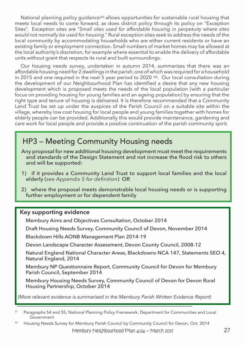
HP3 – Meeting Community Housing needsAny proposal for new additional housing development must meet the requirements
and standards of the Design Statement and not increase the flood risk to others and will be supported:
1) if it provides a Community Land Trust to support local families and the local elderly (see Appendix 5 for definition) OR
2) where the proposal meets demonstrable local housing needs or is supporting further employment or for dependent family
Key supporting evidence Membury Aims and Objectives Consultation, October 2014Draft Housing Needs Survey, Community Council of Devon, November 2014Blackdown Hills AONB Management Plan 2014-19Devon Landscape Character Assessment, Devon County Council, 2008-12Natural England National Character Areas, Blackdowns NCA 147, Statements SEO 4, Natural England, 2014Membury NP Questionnaire Report, Community Council for Devon for Membury Parish Council, September 2014Membury Housing Needs Survey, Community Council of Devon for Devon Rural Housing Partnership, October 2014
(More relevant evidence is summarised in the Membury Parish Written Evidence Report)
28 Membury Neighbourhood Plan 4.04 − March 2017
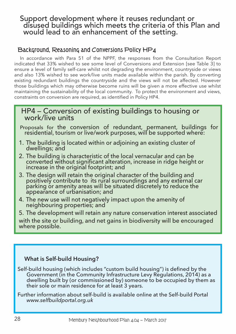
Support development where it reuses redundant or disused buildings which meets the criteria of this Plan and would lead to an enhancement of the setting.
Background, Reasoning and Conversions Policy HP4In accordance with Para 51 of the NPPF, the responses from the Consultation Report
indicated that 33% wished to see some level of Conversions and Extension [see Table 3] to ensure a level of family self-care whilst not degrading the environment, countryside or views and also 13% wished to see work/live units made available within the parish. By converting existing redundant buildings the countryside and the views will not be affected. However those buildings which may otherwise become ruins will be given a more effective use whilst maintaining the sustainability of the local community. To protect the environment and views, constraints on conversion are required, as identified in Policy HP4.
HP4 – Conversion of existing buildings to housing or work/live units
Proposals for the conversion of redundant, permanent, buildings for residential, tourism or live/work purposes, will be supported where:
1. The building is located within or adjoining an existing cluster of dwellings; and
2. The building is characteristic of the local vernacular and can be converted without significant alteration, increase in ridge height or increase in the original footprint; and
3. The design will retain the original character of the building and positively contribute to its rural surroundings and any external car parking or amenity areas will be situated discretely to reduce the appearance of urbanisation; and
4. The new use will not negatively impact upon the amenity of neighbouring properties; and
5. The development will retain any nature conservation interest associatedwith the site or building, and net gains in biodiversity will be encouraged where possible.
What is Self-build Housing?Self-build housing (which includes “custom build housing”) is defined by the
Government (in the Community Infrastructure Levy Regulations, 2014) as a dwelling built by (or commissioned by) someone to be occupied by them as their sole or main residence for at least 3 years.
Further information about self-build is available online at the Self-build Portal www.selfbuildportal.org.uk
29Membury Neighbourhood Plan 4.04 − March 2017
Support schemes which will benefit the parish rural economy and/or society and improve the sustainability of the parish providing they are appropriate to the setting and meet the requirements of this Plan.
Justification for our Small-scale Self Build Housing Policy HP5We have already outlined that affordability of housing is a problem in our rural community.
This is partly due to market forces; an increasing gap between salaries, the amount that can be borrowed and house prices; and also the lack of supply, further driving up house prices. A combination of factors therefore makes housing inaccessible for some people who live locally and who want to get onto the housing ladder, for example, young people and couples who may be living with parents and who wish to remain in the parish but cannot do so. Notwithstanding the gap in supply in our small rural community, in the general sense, there is an affordability gap for people who earn too much to qualify for “affordable housing” (such as social rent or shared equity housing) but earn too little to access a mortgage required to purchase a house on the open market. People and households which fall into this category are often referred to as being in an “intermediate sector”. Traditionally, these people have to rent privately or live with friends or family until they save enough to buy a property.
We have seen, through local consultation, that there is support for small scale housing (which we would term as “organic growth”) and particularly for local people to help provide an opportunity and solution for those who wish to remain in the parish but for whom the usual route to own their own home or move to a larger home to accommodate their needs (for example a growing family) is made difficult [ 33]. Membury village and the hamlets have historically grown slowly in times past. Our consultation has confirmed that a continuation of this pattern and rate of growth is acceptable to residents.
As the new District Local Plan favours development only in towns and villages with a built-up area boundary, currently Membury village and our hamlets are all considered, in policy terms in the Local Plan (in the policy “Strategy 7, Development in the Countryside”), as “open countryside” within which permission for new development is more difficult to secure. Strategy 7 states that “…Development in the countryside will only be permitted where it is in accordance with a specific Local Plan policy that explicitly permits such development…” and subject to other criteria. However, Strategy 27 Development at the Small Towns and Larger Villages does provide the over arching exception where there is a Neighbourhood Plan - ”If communities wish to promote development other than that which is supported through this strategy and other strategies in the Plan (at the settlements listed above or any other settlement) they will need to produce a Neighbourhood Plan or promote community led development (for example Community Land Trusts) justifying how and why, in a local context, the development will promote the objectives of sustainable development.” Strategy 35 also introduces an “exceptions” policy where, subject to certain special criteria being met, local needs housing can be built in special circumstances where need is demonstrated.
Away from the district planning policies, support (in principle) to help enable housing in the countryside (outside the gift of this plan) can be found in the Government’s national planning laws, where certain types of barn conversions to residential dwellings can be acceptable and are classed as “permitted development” negating the need for full planning permission (but where such proposals are subject to “prior approval” through the local authority).
National planning guidance does provide some support for the delivery of local needs housing in rural locations. Paragraph 55 of the National Planning Policy Framework (NPPF) 33 Our neighbourhood plan questionnaire responses showed that 89% of respondents supported new build houses of some sort. Almost 31% supported community led self-build and 63% supported privately owned dwellings. The Housing Needs Survey showed 82% of respondents were in favour of small development.
30 Membury Neighbourhood Plan 4.04 − March 2017
states that “To promote sustainable development in rural areas, housing should be located where it will enhance or maintain the vitality of rural communities. For example, where there are groups of smaller settlements, development in one village may support services in a village nearby.” We believe that small scale organic growth in the parish, where well-related to our settlements, will help to maintain our facilities and services in Membury village, which are a lifeline for some of our residents, help prevent additional car journeys to other villages and towns to get basic provisions, are focal points for residents and which enhance our sense of community. Paragraph 55 of the NPPF goes on to identify criteria or “special circumstances” where development of homes in the countryside may be acceptable, one of which would be due to the ”exceptional quality or innovative nature of the design of the dwelling…” where “such a design should: be truly outstanding or innovative, helping to raise standards of design more generally in rural areas; reflect the highest standards in architecture; significantly enhance its immediate setting; and, be sensitive to the defining characteristics of the local area.”
Taking all of this into account, we consider that self-build (or custom-build) housing schemes may provide a solution to help local people get a home of their own or move within the parish to a home which better suits their household or family’s needs as well as responding positively to the views of our community about what development is acceptable and reasonable in the parish.
Self-build can provide a lower cost solution to local people and support the local economy by providing work for local builders, architects and tradesmen. It can also help to “free-up” the availability of market housing (private rent and owned) as a self-builder will usually be resident in the parish already and will vacate their home when their self-build home is complete.
There is growing support for this method of delivering housing, with the Government having introduced the Self-build and Custom Housebuilding Act in 2015 and, as this plan is being drafted, has consulted on the draft planning guidance which will help the requirements of Act be delivered[ 34]. One of the requirements of the Act is for Local Authorities to maintain a register of people interested in finding or developing a self-build plot. Such registers will provide a useful indicator of demand in the parish for self-build developments. The draft guidance suggests that the registers may be considered as a material consideration when planning applications are being determined (i.e. an issue of relevance to the decision). They should also be taken into account by local authorities in their calculations of housing supply, demand, need and delivery.
Paragraph 50 of the NPPF states that “To deliver a wide choice of high quality homes, widen opportunities for home ownership and create sustainable, inclusive and mixed communities, local planning authorities should plan for…the needs of different groups in the community [including]… people wishing to build their own homes…”. This is recognised by the Local Plan which states “The contribution of self build plots to the supply of new housing is recognised and contributes to the range of homes available. A significant proportion of planning permissions for housing in East Devon are on individual plots, which are likely to be available to those wishing to build/have their own house built. Developers of larger sites will be encouraged to set aside a proportion of plots for sale to individuals or groups wishing to build their own homes (Policy H2 of the Development Management policies).”[ 35] While the Local Plan policy position applies to larger developments, we want to take this principle of support for self-build a step further by providing local support to the development of small scale single self-build dwellings.
Self-build dwellings need to remain occupied by the self-builder for a period of at least 3 years (see box). For a self-build dwelling to remain as a property available for only local residents to access after this period of time, a mechanism such as a legal condition on the sale 34 The draft guidance can be viewed via www.gov.uk/government/publictions/self-build-and-custom-housebuilding-draft-planning-practice-guidance 35 Adopted East Devon Local Plan, paragraph 16.30
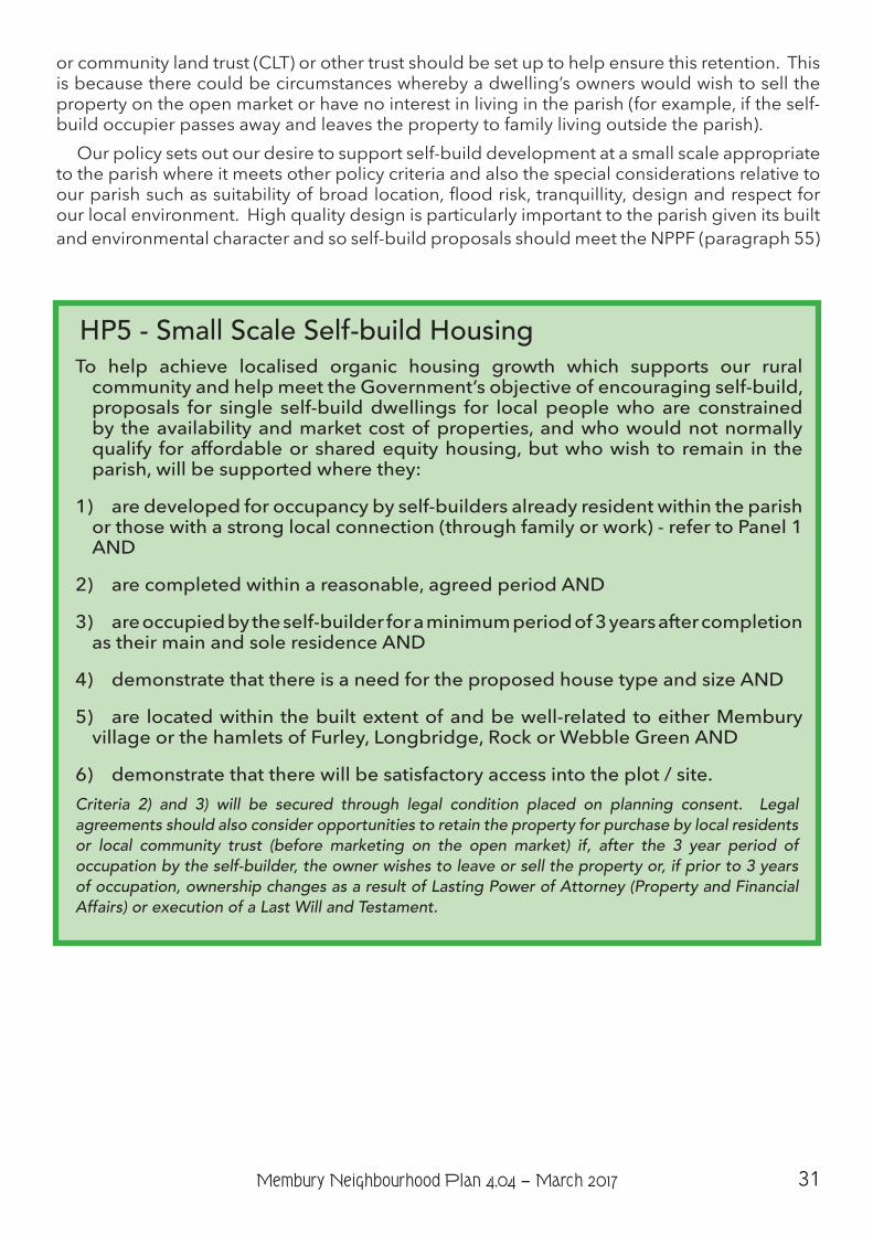
31Membury Neighbourhood Plan 4.04 − March 2017
or community land trust (CLT) or other trust should be set up to help ensure this retention. This is because there could be circumstances whereby a dwelling’s owners would wish to sell the property on the open market or have no interest in living in the parish (for example, if the self-build occupier passes away and leaves the property to family living outside the parish).
Our policy sets out our desire to support self-build development at a small scale appropriate to the parish where it meets other policy criteria and also the special considerations relative to our parish such as suitability of broad location, flood risk, tranquillity, design and respect for our local environment. High quality design is particularly important to the parish given its built and environmental character and so self-build proposals should meet the NPPF (paragraph 55)
HP5 - Small Scale Self-build HousingTo help achieve localised organic housing growth which supports our rural
community and help meet the Government’s objective of encouraging self-build, proposals for single self-build dwellings for local people who are constrained by the availability and market cost of properties, and who would not normally qualify for affordable or shared equity housing, but who wish to remain in the parish, will be supported where they:
1) are developed for occupancy by self-builders already resident within the parish or those with a strong local connection (through family or work) - refer to Panel 1 AND
2) are completed within a reasonable, agreed period AND
3) are occupied by the self-builder for a minimum period of 3 years after completion as their main and sole residence AND
4) demonstrate that there is a need for the proposed house type and size AND
5) are located within the built extent of and be well-related to either Membury village or the hamlets of Furley, Longbridge, Rock or Webble Green AND
6) demonstrate that there will be satisfactory access into the plot / site.Criteria 2) and 3) will be secured through legal condition placed on planning consent. Legal agreements should also consider opportunities to retain the property for purchase by local residents or local community trust (before marketing on the open market) if, after the 3 year period of occupation by the self-builder, the owner wishes to leave or sell the property or, if prior to 3 years of occupation, ownership changes as a result of Lasting Power of Attorney (Property and Financial Affairs) or execution of a Last Will and Testament.
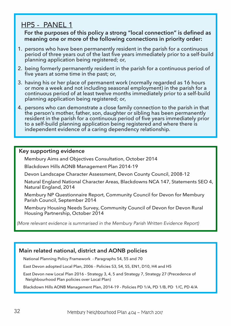
32 Membury Neighbourhood Plan 4.04 − March 2017
HP5 - PANEL 1Forthepurposesofthispolicyastrong“localconnection”isdefinedasmeaning one or more of the following connections in priority order:
1. persons who have been permanently resident in the parish for a continuous period of three years out of the last five years immediately prior to a self-build planning application being registered; or,
2. being formerly permanently resident in the parish for a continuous period of five years at some time in the past; or,
3. having his or her place of permanent work (normally regarded as 16 hours or more a week and not including seasonal employment) in the parish for a continuous period of at least twelve months immediately prior to a self-build planning application being registered; or,
4. persons who can demonstrate a close family connection to the parish in that the person’s mother, father, son, daughter or sibling has been permanently resident in the parish for a continuous period of five years immediately prior to a self-build planning application being registered and where there is independent evidence of a caring dependency relationship.
Key supporting evidence Membury Aims and Objectives Consultation, October 2014Blackdown Hills AONB Management Plan 2014-19Devon Landscape Character Assessment, Devon County Council, 2008-12Natural England National Character Areas, Blackdowns NCA 147, Statements SEO 4, Natural England, 2014Membury NP Questionnaire Report, Community Council for Devon for Membury Parish Council, September 2014Membury Housing Needs Survey, Community Council of Devon for Devon Rural Housing Partnership, October 2014
(More relevant evidence is summarised in the Membury Parish Written Evidence Report)
Main related national, district and AONB policiesNational Planning Policy Framework - Paragraphs 54, 55 and 70
East Devon adopted Local Plan, 2006 - Policies S3, S4, S5, EN1, D10, H4 and H5
East Devon new Local Plan 2016 - Strategy 3, 4, 5 and Strategy 7, Strategy 27 (Precedence of Neighbourhood Plan policies over Local Plan)
Blackdown Hills AONB Management Plan, 2014-19 - Policies PD 1/A, PD 1/B, PD 1/C, PD 4/A
33Membury Neighbourhood Plan 4.04 − March 2017
Community Facilities and Services Aims Objectives
6. Resist the loss of local facilities and amenities (including Car Park, Church, Meeting Place, Playing Field, Post Office, School and Pre-school, Shop, Village Hall) and to protect the area’s heritage (sites and locations).
6a) Support the sensitive and necessary maintenance and improvement of local facilities and amenities to help their continued viability.
IntroductionThere is a real sense of community with The Membury MerryMakers being the central hub
for supporting new and existing organisations. As a result there are currently 11 clubs, societies or organisations within the parish, creating an active social community life.
The parish primary school provides education for some 22 youngsters and has recently added Pre-school to enhance its catchment potential. The School is part of the Acorn Multi-Academy Trust.
The village shop has developed into much more: being the ad-hoc social hub of the parish. It has a Post Office, shop, licenced Meeting Place (where local people and societies can meet at a nominal cost) and being the ”ticket office” and communications hub for any parish activity.
St. John Baptist church sits at the centre of the village and has been in existence since Norman times. It incorporates work of every century from the twelfth to the twentieth.
Quakers Cottage (the former Meeting House) and the Quaker Burial ground form part of the parish history. The burial ground is maintained by the Parish Council.
Changes to Existing Community Facilities and AmenitiesBackground, Reasoning and Policy CFS1To ensure that Membury parish remains a proper community, it is felt strongly that we should
protect the existing local facilities which contribute to our way of life and its quality. Consultation events have demonstrated a desire amongst the local community to ensure that there is no loss of these community facilities and that what we have remain fit for purpose. We acknowledge that changes may have to be made to help our community facilities, amenities and assets to remain relevant, viable and able to meet future needs and demands in an appropriate way. Changes or improvements that require modification, alteration or extension of existing land or buildings however should not be detrimental to the character of the area or our natural assets. Paragraph 28 of the NPPF recognises their value and states that neighbourhood plans should “promote the retention and development of local services and community facilities in villages such as local shops, meeting places, sports venues, cultural buildings, public houses and places of worship”.
This is echoed in Policy CC4/A of the Blackdown Hills AONB Management Plan, 2014-19 which advocates “support the retention or enhancement of community facilities, services and amenities where compatible with the conservation and enhancement of natural beauty and the special qualities of the AONB.”
34 Membury Neighbourhood Plan 4.04 − March 2017
Membury Primary Academy and Pre-SchoolBackground, Reasoning and Policy CFS2The Parish’s Primary School is an important local facility[36], which contributes much to our
sense of community. The school may need to improve or extend its accommodation and facilities to meet future educational needs of the parish and the wider catchment area. We shall work with the school’s governors to ensure that the school is able to continue to offer a first class, modern, education. We will also support proposals that enable the school’s facilities to be more accessible to the community at large. We have identified community actions to take this forward.
Recognised community facilities, amenities and servicesSt John Baptist Church, Quaker Burial Ground, Membury Castle, Membury Court Chapel,
Beckford Packhorse bridge, Village Hall, Car Park, Playing Field, Membury Primary School Academy & Pre-school, Membury Post Office, Shop and Meeting Place.
Policy CFS1 – Changes to Existing Local Community Facilities, Amenities and Assets
Proposals which relate to Membury’s existing local community facilities, amenities and assets will be supported where:
1) there is a demonstrable need for the change;
2) they do not have an adverse impact on the special character of the area’s natural and built environments.
Policy CFS2 – Membury Primary AcademyProposals for development that lead to the provision of new, additional or
the improvement of existing facilities at Membury Academy, which serve an educational and / or community purpose, will be supported where they do not have an adverse impact on the special character of the area’s natural and built environments.
Related national and district policiesEast Devon new Local Plan adopted March 2016 - Strategy 27, Policies RC6, RC7
36 Ref: Paragraph 72 NPPF
35Membury Neighbourhood Plan 4.04 − March 2017
Loss of Local Community Facilities, Amenities and Locally Valued Assets through Redevelopment
Background, Reasoning and Policy CFS3Our aim is to maintain and increase, not decrease, the range of facilities that serve the local
community. We will oppose any proposal that results in a loss of such facilities through the conversion, demolition or redevelopment of any site or building in the Parish. We will work with organisations and businesses that wish to ensure that Membury has the facilities and amenities it requires.
Paragraph 70 of the NPPF states that planning policies should: guard against the unnecessary loss of valued facilities and services, particularly where this would reduce the community’s ability to meet its day-to-day needs. Strategy 27 in the new East Devon Local Plan also states that the “loss of existing facilities will be resisted”.
Policy CFS3 - Loss of Local Community Facilities, Amenities and Locally Valued Assets through Redevelopment or Change of Use
Proposals for the redevelopment or change of use of locally valued community assets will only be supported where:
1. there is no reasonable prospect of viable continued use of the existing building or facility which will benefit the local community and they demonstrate a need for the proposed change AND
2. planning approval for ”change of use” of any named local facility or amenity will be granted only after it has been expertly marketed at a market price for at least two years AND
3. they do not have an adverse impact on the special character of the area’s natural and built environments AND
4. they have been subject to consultation with the local community AND
5. they will not result in the net loss of a community facility where need and demand for that facility and / or an alternative community use has been demonstrated.
Community Actions and ProjectsCA16 - We shall work with the School’s governors to ensure that the school is able
to continue to offer a first class education to all of the local children of the parish and wider area.
CA17 – Explore further use of school facilities by the community.
Key supporting evidenceMembury Parish Community Appraisal, Parish Plan, 2000Membury NP Questionnaire Report, Community Council for Devon for Membury
Parish Council, September 2014Membury Aims and Objectives Consultation, October 2014(More relevant evidence is summarised in the Membury Parish Written Evidence Report)
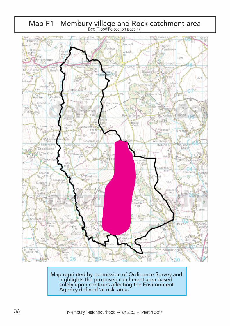
36 Membury Neighbourhood Plan 4.04 − March 2017
Map F1 - Membury village and Rock catchment area (see Flooding section page 37)
Map reprinted by permission of Ordinance Survey and highlights the proposed catchment area based solely upon contours affecting the Environment Agency defined ’at risk’ area.
37Membury Neighbourhood Plan 4.04 − March 2017
FloodingAim Objectives
7. Control and where possible reduce flood risk
7a) To work with East Devon District Council and applicants to ensure that any new development, alteration or extension is at least flood neutral and to ensure that specific reference to surface water run-off handling is addressed in the planning application.
7b) To work with East Devon District Council to ensure that the flood scheme installed and maintained by that authority is kept in full working order. In particular the collection tank [sump] at the head of the scheme and the grille outside Membury Follie must be kept clear of debris.
IntroductionIn general terms, the parish is split geologically between chalk based and clay based sub-
structure. This is nowhere more evident than in Membury village where, to the east of the main street the parish is mainly clay and to the west chalk.
Both Membury village and the hamlet of Rock lie on the valley floor - the valley running from Selah in the north to Lewsley Lane in the south. [see Map F1] This valley and its sides form the catchment area which causes most of the flood risk in the parish.
Some work to reduce the risk of flooding was undertaken in October 1976. One new culvert was constructed and two existing ones improved.
In September 1981 work started on a more comprehensive flood alleviation scheme which consists of a collection pit [sump] and weir at the southern end of Bond’s Lane (BW33) and a channel under the street which extends as far as the war memorial. There is also a short section past Membury Follie.
The Environment Agency [EA] installed a flood warning siren in the village car park in 2012, which is backed up by self-help measures and a volunteer-organised local ring-around scheme and volunteer Flood Wardens. The storm drain has a sump and weir at its start, at the south end of Bonds Lane. Provided that the street drain-holes, storm drain gullies and the sump are kept clear of debris the scheme has proven invaluable.
Under the auspices of the Parish Council, flooding incidents over the years have been the source of traumatic learning reflected in local knowledge base and modifications to the volunteer procedures and their Flood Emergency Plan. However, flash flooding remains a problem and the valley bottom running from Challenger Farm through the centre of Membury and Rock has been designated as a Zone 3 (1% chance) Flood Risk by EA. This has been exacerbated by the increased area of hard-surfaces under devolved planning rights and EA approved covered clean and dirty water farm yard buildings within the catchment area. This increased rate of run-off can overwhelm the system.
38 Membury Neighbourhood Plan 4.04 − March 2017
Further, planting of trees at the head of Bonds Lane [BW 33] was established in 2013 to slow down, delay and filter the floodwater emanating from the northern end of the catchment. Since BW33 has been closed by the County Council the lane has become filled with thick vegetation. This has had the effect of slowing down floodwater and trapping debris.
At the time of writing, there are numerous records of occasions when up to 10 properties
have been flooded: 1st October 1976, 20th December 1989, 1st January 1998, 31st December 2000, 4th February 2002, 1st February 2004, 13th December 2008, 21st November 2012, 24th November 2012, 25th January 2013 and these and other incidents, action plans and discussions have been discussed at Parish Council and Annual Public meetings listed in Appendix 4 Supporting Evidence. There are also records of flooding of properties outside the centre of the village.
As can be seen from the data in Appendix 4, there have been at least 9 occasions when the scheme has failed to prevent flooding due to ”flash” flooding following either severe short period rainfall in the catchment area or blockage of the storm drain sump or gullies.
The NPPF paragraph 100 says ” Inappropriate development in areas at risk of flooding should be avoided by directing development away from areas at highest risk, but where development is necessary, making it safe without increasing flood risk elsewhere.”
F1 New build, self-build, conversion or extensionTo control and where possible reduce flood risk:-
a) within the catchment area defined on Map F1:
1. All planning applications within the catchment area (Map F1) should include a flood risk assessment.
2. Where a planning application from within the catchment area defined in Map F1 has been approved, a condition removing permitted development rights should be applied
b) All planning applications
1. Sustainable drainage systems should be provided unless demonstrated to be inappropriate and
2. Design must ensure that the development does not increase the flood risk to other properties and specific reference to surface water handling must be addressed in the planning application AND
3. The application must demonstrate, as a minimum, compliance with Government-issued Best Practice guidelines which are extant at the time of the application.
4. All new surface water drainage must be into a demonstrably adequate soak-away or other effective storage and slow-release system.
5. Any new or replacement hard-standing within either an existing curtilage or new-build property must comply with best practice regarding surface water permeability, irrespective of the area covered by the hard-standing.
39Membury Neighbourhood Plan 4.04 − March 2017
Community Actions and ProjectsCA 18 - The Parish Council to ensure that a Flood Warden or Wardens are appointed
with the particular responsibility for checking that the collection pit outfall pipe and roadside storm gullies are not blocked and maintain and update as necessary the Flood Emergency Plan.
CA19 - The Parish Council to work with the Environment Agency to ensure that the warning siren is maintained in full working order.
CA20 - The Parish Council to continue to put pressure on Devon County Council to undertake a Flood Risk Assessment, first requested on 30th July 2013.
CA21 - Any plans to reopen BW33 should include systems to ensure that floodwater speeds do not return to the previous damaging levels.
CA22 - The Parish Council to work with the County Council, Environment Agency and landowners to consider further measures to reduce flood risk.
Key supporting evidenceBlackdown Hills AONB Management Plan 2014-19Membury NP Questionnaire Report, Community Council for Devon for Membury
Parish Council, August 2014Membury Aims and Objectives Consultation October 2014
40 Membury Neighbourhood Plan 4.04 − March 2017
Transport and AccessAims Objectives
8. Maintain and enhance the network of footpaths and bridleways.
8a) Support the position of Footpath Warden under the Parish Council.
8b) Support small-scale improvement projects for footpaths and bridleways.
IntroductionMembury parish is served by a network of narrow lanes typical of rural East Devon and the
Blackdown Hills. The main access road into and out of the Parish runs north-south connecting the A30, which clips the northern tip of the parish, with the A35 to the south, at Axminster and by-passes the main village, ensuring that traffic in the centre of Membury is relatively light and mostly local. As a parish community we are very car-dependent; there is no bus service. Car ownership is high – only 5% of households do not have regular access to a motor vehicle. Fortunately the parish is also served by the Fare Car (community transport) service. Recent consultation shows that travel and traffic issues are few and most people accept and enjoy their relative seclusion. It is pleasing to record that many local people enjoy walking. Our intent is to recognise the necessity of the motor car and enhance both the intra-support within the parish whilst continuing to make walking, riding and cycling safer and more appealing.
Rights of Way (Public Footpaths, Bridleways and Cycleways)
Background, Reasoning and Policy TRA1As a community we appreciate the footpath and bridleway network and wish to enjoy the
natural environment in our parish in a way that is safe and not detrimental to the countryside or those that inhabit or work within it. We wish to see this maintained and, where or if appropriate, enhanced. The voluntary position of Footpath Warden - appointed through the Parish Council - is one that we wish to see maintained and supported.
Policy TRA1 – Rights of Way (Public Footpaths and Bridleways)Proposals for development of or affecting public rights of way will be supported
where:
1) they promote, protect, maintain and enhance the existing local footpath and bridleway network for use on foot, bicycle or horseback;
2) they improve and enhance the existing network through the provision of new or extended routes;
3) they prevent motorised vehicles (except those specifically designed for the disabled) illegally using designated footpaths, bridleways and cycleways (where established).
41Membury Neighbourhood Plan 4.04 − March 2017
Key supporting evidenceBlackdown Hills AONB Management Plan 2014-19Membury NP Questionnaire Report, Community Council for Devon for Membury
Parish Council, August 2014Membury Aims and Objectives Consultation October 2014
(More relevant evidence is summarised in the Membury Parish Written Evidence Report)

42 Membury Neighbourhood Plan 4.04 − March 2017
Economy and EmploymentAims Objectives
9. Help create, support and sustain local businesses.
9a) Actively pursue advances in communication technology and support the provision of high-speed broadband and mobile phone signal to every property in the parish.
9b) Support the diversification of farm businesses and the conversion of agricultural buildings where it is shown to be necessary to help ensure the continued viability of the farm.
9c) Encourage measures to uphold best practice farming methods, especially the management of land within a flood catchment area.
IntroductionMembury is a rural community with a rural economy based on agriculture. There is an above
average (20%) level of those of working-age working from home[37] within the local economy. We envisage the character of the economy and employment patterns showing an ever increasing number of people working from home and our proposals are aimed at supporting this whilst protecting the overall character of the Parish.
Pursue advances in communications technology - Super-fast Connectivity
Background, Reasoning and Policy EE1We recognise that good mobile phone connection and regular use of the internet and
social media is important if we are to maintain our quality of life and allow local businesses to flourish. Fast and reliable connection will be essential in future for running successful businesses, accessing services and assistance, furthering education and creating a breadth of opportunities for personal growth and development. We are intent on establishing and maintaining the necessary level of connectivity. While the main driver for our policy is to help sustain and improve the local economy, the need for improved provision extends beyond the traditional business premises and office as many people are now working from home or running a business from home which could require high speed broadband connectivity. There are naturally positive spin-offs in ensuring improved connectivity speeds to households on this basis as the use of the internet for social interaction, education and access to essential services increases with time.
However, this cannot be done at any cost and so recognising the special quality of our natural and built environment, to minimise the visual impact of new connectivity infrastructure such as cabling or telecoms boxes or hubs for super-fast fibre broadband, such infrastructure should be appropriately sited, sympathetically designed and camouflaged so that it is in keeping with its setting and surroundings.
Faster broadband is identified as the biggest need to support employment within the parish.
37 Ref: ACRE/DCC Rural profile for Membury Parish Council
43Membury Neighbourhood Plan 4.04 − March 2017
Given the numbers working from home or considering it, faster broadband would be important in supporting this, as would improved mobile phone signals.
Conversion of Agricultural BuildingsBackground, Reasoning and Policy EE2Farming is a vital component of our parish and its economy. We will help ensure that farming
businesses can remain viable by permitting the conversion or redevelopment of existing farm buildings where it can be shown that it will make a difference to the business but have little or no impact on the character of its surroundings.
Policy EE1 – Super-fast ConnectivityThe development of a super-fast broadband infrastructure to serve the Parish will
be supported where it is sensitively sited and sympathetically designed.
Community Actions and ProjectsCA23 - The Parish Council will make every reasonable effort to keep abreast of
evolving advances in communications technology so that the parish as a whole can benefit.
CA24 - The Parish Council will recognise the importance of mobile signals and broadband or other means of accessing online data and take advice, make representations and lobby, and work with providers, as well as other parishes and organisations to try and obtain effective communications within the parish.
CA25 - It is acceptable for there to be some limited visual impact in order to achieve mobile phone communication, should this be necessary. However, proposals must take into account that this is an AONB.
CA26 - Work with providers to accelerate the introduction of a reliable parish-wide mobile phone signal.
Related national and district policiesNational Planning Policy Framework - Paragraphs 42-43East Devon new Local Plan (Proposed Submission Version 2012 as amended in
2013) - Strategy 27 and Policy RC6
Key supporting evidenceMembury NP Questionnaire Report, Community Council for Devon for Membury
Parish Council, August 2014Membury Aims and Objectives Consultation, October 2014Membury NP Questionnaire Report, Aug 2014(More relevant evidence is summarised in the Membury Parish Written Evidence Report)
44 Membury Neighbourhood Plan 4.04 − March 2017
The NPPF (paragraph 28) calls for polices that support a prosperous rural economy. It states that planning policies should “support the sustainable growth and expansion of all types of business and enterprise in rural areas, both through conversion of existing buildings and well-designed new buildings”.
In the spirit of this national policy we will not oppose the careful and sensitive conversion and alteration of existing agricultural buildings for business-related purposes. Any development however must conform to other policies in the Local Plan and Neighbourhood Plan that are aimed at protecting the character, tranquillity and visual appearance of the area.
The AONB Management Plan recognises the need to:
• Support rural diversification which contributes to business viability, develops local markets and adds value to local products without compromising the conservation and enhancement of natural beauty and the special qualities of the AONB (Policy RET 1/A)
• Encourage the development of sustainable employment opportunities that are compatible with conserving and enhancing natural beauty and the special qualities of the AONB, and encourage people to continue to live and work within their communities (Policy RET 1/B)
• Support the development of sustainable tourism activities that are compatible with conserving and enhancing natural beauty and the special qualities of the AONB, and encourage people to continue to live and work within their communities (Policy RET 1/C)
Our policy is intended to facilitate the conversion of redundant agricultural buildings in the interests of increasing the viability of the farm business whilst ensuring the conversion and reuse is compatible with its setting and the special character of the AONB.
Policy EE2 – Conversion of Agricultural BuildingsTo support farm diversification, the conversion of existing agricultural buildings for
business or business-related purposes will be supported where:
1. the proposal would be compatible with its landscape setting, AND
2. the local road network could safely accommodate the increase in vehicles resulting from the proposal; AND,
3. the proposal complements, or is otherwise compatible with the agricultural or other land-based activities present in the area; AND,
4. the proposal would not harm the amenity of neighbouring residents and/or other uses; AND,
5. the buildings concerned would not require substantial rebuilding or disproportionate extension.
45Membury Neighbourhood Plan 4.04 − March 2017
FarmingBackground, Reasoning and Farming New Development Policy EE3
The NPPF (para. 109) states that the planning system should contribute to and enhance the natural and local environment by:
• “protecting and enhancing valued landscapes, geological conservation interests andsoils;
• recognisingthewiderbenefitsofecosystemservices
• minimisingimpactsonbiodiversityandprovidingnetgainsinbiodiversitywherepossible,contributingtotheGovernment’scommitmenttohalttheoveralldeclineinbiodiversity,includingbyestablishingcoherentecologicalnetworksthataremoreresilienttocurrentand futurepressures
• preventingbothnewandexistingdevelopment fromcontributing toorbeingputatunacceptableriskfrom,orbeingadverselyaffectedbyunacceptable levelsofsoil,air,waterornoisepollutionorlandinstability
• remediatingandmitigatingdespoiled,degraded,derelict,contaminatedandunstableland,whereappropriate”
Farming has described and defined the character of the natural and local environment of our parish for centuries. Changes in farming methods should not put this special and unique character at risk.
The community has made it clear at recent consultation events that it supports measures to uphold best-practice farming methods. Therefore where the proposed change is not enabled by the General Permitted Development Order, we will resist developments and changes on farmland that are likely to have an adverse effect on the established rural landscape or best-practice agricultural methods.
Should new development be deemed necessary it should meet the requirements of the East
Key supporting evidenceMembury Aims and Objectives Consultation, October 2014Membury NP Questionnaire Report, Community Council for Devon for Membury
Parish Council, August 2014(More relevant evidence is summarised in the Membury Parish Written Evidence Report)
Related national and district policiesNational Planning Policy Framework - Paragraph 28East Devon new Local Plan (Proposed Submission Version 2012 as amended in
2013) - Policies D8, E16 Blackdown Hills AONB Management Plan, 2014-19 – Policies RET/1B and PD/1C
46 Membury Neighbourhood Plan 4.04 − March 2017
Devon new Local Plan - Policies EN13 and D7, and Policy EE3 (below) of the Neighbourhood Plan. Policy D7: Agricultural Buildings and Development, of the new Local Plan, states that (sic):
“New agricultural buildings and/or buildings intended for intensive agricultural activities that could give rise to adverse amenity, landscape, environmental or other impacts will be permitted where there is a genuine agricultural need for the development and the following criteria are met:
1. It is well integrated with its surroundings and closely related to existing buildings, being ofappropriate location, scale, design and materials so as not to harm the character,biodiversity and landscape of the rural area particularly within the AONB.2. It will not be detrimental to the amenity of nearby residents on grounds of smell, noise orfly nuisance.4. It has been established that there are no other suitable buildings on the holding or in thevicinity which could meet the reasonable need.5. It will not lead to an unacceptable increase in traffic on the local highway network6. All clean roof and surface waters will be drained separately from foul drainage and fouldrainage will not discharge to any watercourse in order to prevent pollution of the waterenvironment.Proposals for the development of new large scale buildings for livestock or for other use that could
have polluting impacts should be accompanied by a Waste Management Plan.”
Related national and district policiesNational Planning Policy Framework / National Planning Practice Guidance -
Paragraphs 109 and 112East Devon new Local Plan (Proposed Submission Version 2012 as amended in
2013) - Policies EN13, D7
Key supporting evidenceMembury Parish Biodiversity Audit, 2014Membury NP Questionnaire Report, Community Council for Devon for Membury
Parish Council, August 2014Membury Aims and Objectives Consultation, October 2014(More relevant evidence is summarised in the Membury Parish Written Evidence Report)
Policy EE3 – Farming (New Development Proposals)In all cases, new agricultural development proposals requiring planning permission
will be expected to demonstrate how they will protect and/or enhance best practice farming methods and the rural characteristics of the surrounding area and demonstrate how the proposal protects and promotes the natural beauty and special character of the AONB landscape.
Community Actions and ProjectsCA27 - Encourage measures to uphold best practice farming methods,
especially the management of land within a flood catchment area.

47Membury Neighbourhood Plan 4.04 − March 2017
Energy and Low CarbonAim Objectives
10. Support small scale, unobtrusive renewable or low carbon energy schemes providing they are sensitively sited and screened (appropriately landscaped).
10a) Ensure that any renewable or low carbon energy schemes are sensitively sited and screened (appropriately landscaped) to protect the essential qualities of the AONB.
10b) Resist large-scale and obtrusive renewable or low carbon energy schemes that are likely to have a negative impact on enjoyment of the natural and built environment and are contrary to our Vision.
10c) Develop possible ecological solutions to energy conservation and generation using any natural features within the constraints of all other policies
IntroductionWe recognise the importance and value that renewable and low carbon energy schemes (and
improvements to energy efficiency of buildings where done sensitively) can have in helping provide alternatives to fossil based fuels and therefore help reduce carbon dioxide emissions, improve the security of energy supply, reduce households bills for energy, generate an income for community organisations and businesses and reduce the cost of supply of energy.
However, in practical terms, different types of renewable and low carbon energy installations will be suitable in different built and natural landscapes. We have already set out how we value our natural landscape and tranquillity in Membury within the context of the AONB and the policies we have developed on energy proposals reflect this position.
Small and Large Scale Renewable and Low Carbon Energy Schemes
Background, Reasoning and Policies ELC1 (Small Scale) and ELC2 (Large scale)
Evidence we have gathered[38], together with the views of our local community, have identified support for smaller scale renewable and low carbon energy schemes which respect the qualities of the landscape and natural environment as a whole and do not have an adverse impact on the beauty of and biodiversity within our parish.
This includes the findings of the “Renewable Energy in the Blackdown Hills” report which assessed the suitability, in broad terms, in the AONB of different types and scales of renewable and low carbon energy solutions. Table 4 below, reproduced from the “Renewable Energy in the Blackdown Hills” report[39], sets out this position and also helpfully confirms what we mean in our policies by “small scale” and “large scale” renewable energy installations.
38 Such as the Blackdown Hills Management Plan, 2014; the Renewable Energy in the Blackdown Hills Report, 2010; and, the Accommodating Wind and Solar PV Developments in the Devon Landscape: Advice Note, 2013.39 p.9, Renewable Energy in the Blackdown Hills Report, Land Use Consultants in association with the Centre for Sustainable Energy, 2010
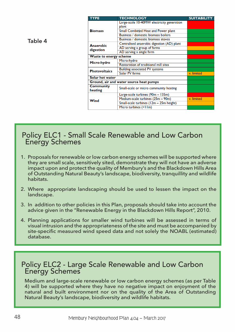
48 Membury Neighbourhood Plan 4.04 − March 2017
Table 4
Policy ELC1 - Small Scale Renewable and Low Carbon Energy Schemes
1. Proposals for renewable or low carbon energy schemes will be supported where they are small scale, sensitively sited, demonstrate they will not have an adverse impact upon and protect the quality of Membury’s and the Blackdown Hills Area of Outstanding Natural Beauty’s landscape, biodiversity, tranquillity and wildlife habitats.
2. Where appropriate landscaping should be used to lessen the impact on the landscape.
3. In addition to other policies in this Plan, proposals should take into account the advice given in the “Renewable Energy in the Blackdown Hills Report”, 2010.
4. Planning applications for smaller wind turbines will be assessed in terms of visual intrusion and the appropriateness of the site and must be accompanied by site-specific measured wind speed data and not solely the NOABL (estimated) database.
Policy ELC2 - Large Scale Renewable and Low Carbon Energy Schemes
Medium and large-scale renewable or low carbon energy schemes (as per Table 4) will be supported where they have no negative impact on enjoyment of the natural and built environment nor on the quality of the Area of Outstanding Natural Beauty’s landscape, biodiversity and wildlife habitats.
49Membury Neighbourhood Plan 4.04 − March 2017
Community Actions and ProjectsCA28 - Encourage possible ecological solutions to energy conservation and
generation using any natural features within the constraints of all other policies.
Key supporting evidence
Blackdown Hills AONB Management PlanDevon Landscape Character Assessment, Devon County CouncilNatural England National Character Areas, Blackdowns NCA 147, Statements
SEO2, 3 and 4Renewable Energy in the Blackdown Hills ReportAccommodating Wind and Solar PV Developments in the Devon Landscape:
Advice Note(More relevant evidence is summarised in the Membury Parish Written Evidence Report)
Main related national, district and AONB policies
National Planning Policy FrameworkEast Devon new Local Plan - Strategy 39, Strategy 41Blackdown Hills AONB Management Plan, 2014-19 - Policies PD 1/A, PD 1/B, PD
2/B, CC 4/B
50 Membury Neighbourhood Plan 4.04 − March 2017
Monitoring and ReviewWhile there is no statutory requirement for the impact of this Plan and its policies to be
monitored, the Parish Council will periodically monitor the impact of policies on change in the parish by considering the policies’ effectiveness in the planning application decision making process. The Parish Council will do this by referring to this Plan when reviewing planning applications. The Clerk will keep a record of the application, any applicable policies, the comment from the Parish Council and the eventual outcome of the application. The delivery of community actions that have been identified will also be periodically monitored.
A full or partial review of this Plan is unlikely to be considered necessary during its lifetime unless triggered by changes to legislation, changes to national or District-wide planning policies or significant planning issues being raised by the local community which cannot be dealt with effectively by a combination of national, district and / or existing neighbourhood plan policies.
51Membury Neighbourhood Plan 4.04 − March 2017
AppendicesAppendix 1Refer to Built and Historical Environment policy BHE1.2 Historical and architectural assets -
see www.historicengland.org.uk
Listed Buildings and Historical Sites within Membury Parish
1. Crawley Bridge2. Nimrods3. April Cottage4. Lea Hill Farm Hotel5. Cleave Hill6. Grey Farmhouse7. North Grey Farmhouse8. Stotehayes9. Kinders10. Colecroft Cottage11. Barn Immediately West Of Osmore Farmhouse12. Rock House13. Forge Cottage14. Gaffers15. Toehill16. Land Farm House17. Land Cottage And Lancet Barn Approximately 23 Metres North North-East Of Land Farm
House18. Yarty Farm House Including Former Bakehouse Immediately South West19. Converted Farm Building Immediately South Of Higher Yartyford20. Barn Immediately North Of Lower Yartyford21. Gapper’s Farmhouse22. Orchards, Yartyford Lane23. Former Chapel Immediately North Of Membury Court24. Linhay Immediately West Of Membury Court25. Footbridge Immediately South Of Membury Court26. Goodmans27. Stables Immediately North Of Ford Farmhouse28. Godworthy Farmhouse29. Trebblehayes30. Gilletts Farmhouse31. Membury Court32. Barn Approximately 50 Yards West Of Membury Court33. Barn Immediately South East Of Brinscombe Farmhouse34. Ford Farmhouse35. Barn Approximately 20 Yards North East Of Ford Farmhouse, Casehayes Lane36. Haveland, Chard Road37. Stevens Farmhouse, Crawley Common38. Rose Cottage, Furley39. Barn Adjoining West And South West Of Lugg’s Farmhouse40. Moxhayes Farmhouse41. Church Of St John The Baptist42. North Mill House
52 Membury Neighbourhood Plan 4.04 − March 2017
43. Osmore Farmhouse44. Rock Cottage45. Rock Mill46. Quakers47. Cottage Immediately South East Of Toehill48. Higher Yartyford49. Lower Yartyford50. Wall Immediately South East Of Lower Yartyford51. Barn Immediately South Of Osmore Farmhouse52. Farm Building Immediately South East Of Gapper’s Farmhouse53. Long Orchard54. West Barn Approximately 23 Metres North Of Land Farm House55. Garden Boundary Wall East Of Osmore Farmhouse56. Crawley Farmhouse57. Rices58. Hasland Farm House59. Bridge Meadow, Crawley Common60. Goddards61. Rosemary Cottage, Heath Common62. Knightslands, Hill Common63. Lugg’s Farmhouse Including Outbuilding Adjoining South East64. The Folly65. Former Water Mill Immediately North Of North Mill House66. Inglenook Cottage67. Membury War Memorial68. The Below Ground Remains Of The Former Chapel At Membury Court69. Membury Castle70. Beckford Bridge
Appendix 2 Membury Design Statement See pages 53 - 58 inclusive
Appendix 3Blackdown Hills Area of Outstanding Natural Beauty ”Design Guide for Houses”.
This is available at www.blackdownhillsaonb.org.uk
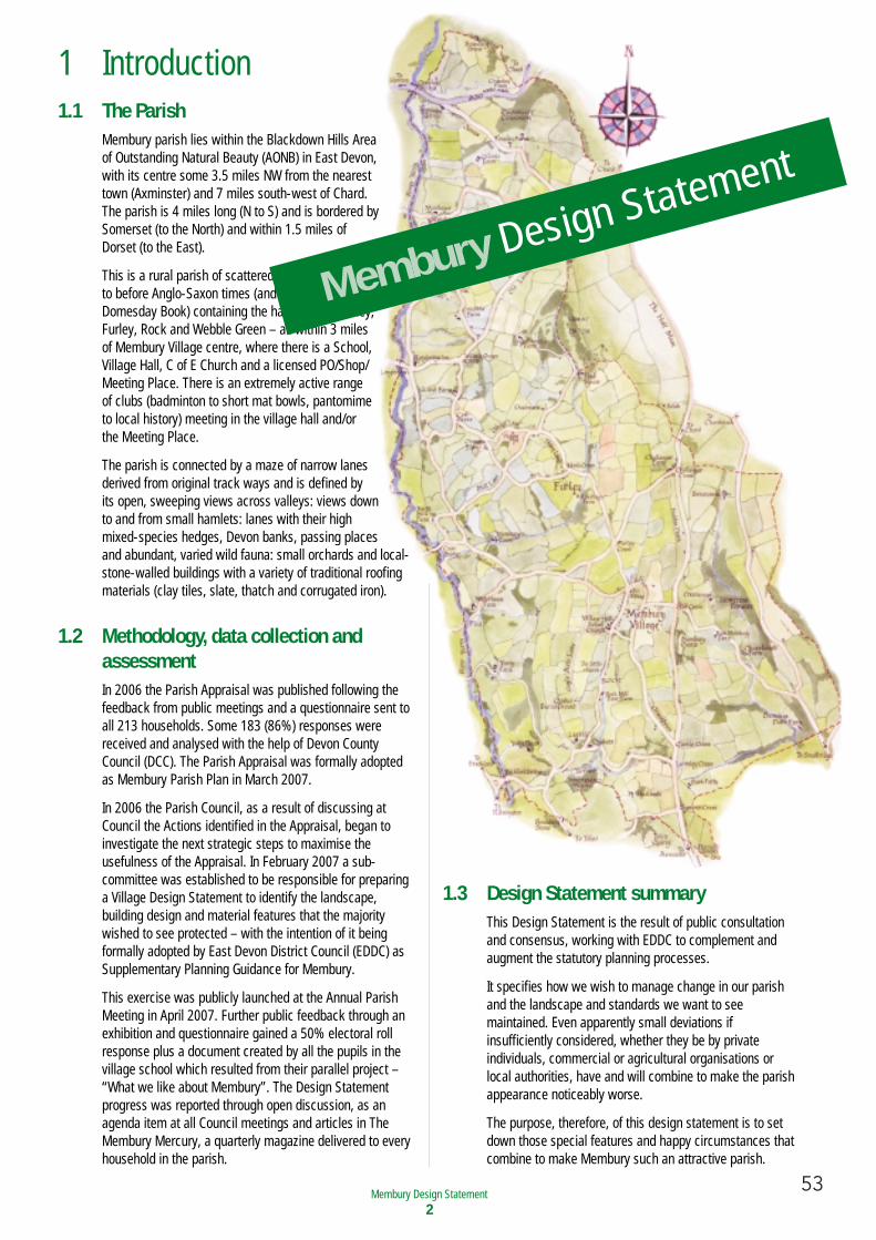
53Membury Neighbourhood Plan 4.04 − March 2017Membury Design Statement
2
1 Introduction1.1 The Parish
Membury parish lies within the Blackdown Hills Area of Outstanding Natural Beauty (AONB) in East Devon, with its centre some 3.5 miles NW from the nearest town (Axminster) and 7 miles south-west of Chard. The parish is 4 miles long (N to S) and is bordered bySomerset (to the North) and within 1.5 miles of Dorset (to the East).
This is a rural parish of scattered farms, dating back to before Anglo-Saxon times (and mentioned in theDomesday Book) containing the hamlets of Crawley, Furley, Rock and Webble Green – all within 3 miles of Membury Village centre, where there is a School, Village Hall, C of E Church and a licensed PO/Shop/ Meeting Place. There is an extremely active range of clubs (badminton to short mat bowls, pantomime to local history) meeting in the village hall and/or the Meeting Place.
The parish is connected by a maze of narrow lanes derived from original track ways and is defined by its open, sweeping views across valleys: views down to and from small hamlets: lanes with their high mixed-species hedges, Devon banks, passing places and abundant, varied wild fauna: small orchards and local-stone-walled buildings with a variety of traditional roofingmaterials (clay tiles, slate, thatch and corrugated iron).
1.2 Methodology, data collection andassessmentIn 2006 the Parish Appraisal was published following thefeedback from public meetings and a questionnaire sent toall 213 households. Some 183 (86%) responses werereceived and analysed with the help of Devon CountyCouncil (DCC). The Parish Appraisal was formally adoptedas Membury Parish Plan in March 2007.
In 2006 the Parish Council, as a result of discussing atCouncil the Actions identified in the Appraisal, began toinvestigate the next strategic steps to maximise theusefulness of the Appraisal. In February 2007 a sub-committee was established to be responsible for preparinga Village Design Statement to identify the landscape,building design and material features that the majoritywished to see protected – with the intention of it beingformally adopted by East Devon District Council (EDDC) asSupplementary Planning Guidance for Membury.
This exercise was publicly launched at the Annual ParishMeeting in April 2007. Further public feedback through anexhibition and questionnaire gained a 50% electoral rollresponse plus a document created by all the pupils in thevillage school which resulted from their parallel project –“What we like about Membury”. The Design Statementprogress was reported through open discussion, as anagenda item at all Council meetings and articles in TheMembury Mercury, a quarterly magazine delivered to everyhousehold in the parish.
1.3 Design Statement summaryThis Design Statement is the result of public consultationand consensus, working with EDDC to complement andaugment the statutory planning processes.
It specifies how we wish to manage change in our parishand the landscape and standards we want to seemaintained. Even apparently small deviations ifinsufficiently considered, whether they be by privateindividuals, commercial or agricultural organisations orlocal authorities, have and will combine to make the parishappearance noticeably worse.
The purpose, therefore, of this design statement is to setdown those special features and happy circumstances thatcombine to make Membury such an attractive parish.
Membury Design Statement
Contents
Page
Introduction
2
History
3
The landscape
4
Design and materials5
© Membury Parish Council – April 2008

54 Membury Neighbourhood Plan 4.04 − March 2017Membury Design Statement
3
2 History Contributed by the Membury Local History Society
“When I was young I felt in my bones thatthe landscape itself was speaking to me.”Prof. W.E Hoskins
People who have had the good fortune to live in the parishof Membury for several years must have become aware ofthe many different facets that have produced its uniquelandscape and history.
The Iron Age ‘Castle’ that gave the village its name; itslanes, old roads and trackways that provide keys to itssettlement patterns; the names and layout of the fields thatreflect the development of agriculture from the very earliestof times – these define Membury.
Whilst we have archaeological evidence of the presence ofman within the parish from at least Neolithic times throughto the Romans, written records associate the parish withKing Athelstan and the Norman occupation onwards.
The parish has been ‘owned’ by kings and abbeys (andtheir underlings) but the people – being so far from thesecentres of administration – have always displayed anindependent, nonconformist spirit, as evidenced by thosewho fought in the Civil War, followed the Duke ofMonmouth to Sedgemoor or joined the Quaker movement.Our most well-known local campaigner was ThomasWakley (MP and founder of The Lancet) who supported therights of the Tolpuddle martyrs, spoke out against floggingin the army and the inhumanity of the workhouse.
Today we still celebrate the restoration of the monarchy onOak Apple Day in the churchyard of St. John Baptist. We aretruly unique — we must preserve our uniqueness.
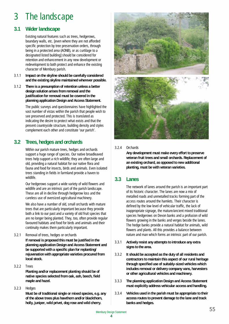
55Membury Neighbourhood Plan 4.04 − March 2017Membury Design Statement
4
3 The landscape3.1 Wider landscape
Existing natural features such as trees, hedgerows,boundary walls, etc. [even where they are not affordedspecific protection by tree preservation orders, throughbeing in a protected area (AONB), or as curtilage to adesignated listed building] should be considered forretention and enhancement in any new development orredevelopment to both protect and enhance the existingcharacter of Membury parish.
3.1.1 Impact on the skyline should be carefully consideredand the existing skyline maintained wherever possible.
3.1.2 There is a presumption of retention unless a betterdesign solution arises from removal and thejustification for removal must be covered in theplanning application Design and Access Statement.
The public surveys and questionnaires have highlighted thevast number of vistas within the parish that people wish tosee preserved and protected. This is translated asindicating the desire to protect what exists and that thepresent countryside structure, building density and stylescomplement each other and constitute ‘our parish’.
3.2 Trees, hedges and orchardsWithin our parish mature trees, hedges and orchardssupport a huge range of species. Our native broadleavedtrees help support a rich wildlife; they are often large andold, providing a natural habitat for our native flora andfauna and food for insects, birds and animals. Even isolatedtrees standing in fields in farmland provide a haven towildlife.
Our hedgerows support a wide variety of wild flowers andwildlife and are an intrinsic part of the parish landscape.These are all in decline through hedgerow loss and thecareless use of oversized agricultural machinery.
We also have a number of old, small orchards with maturetrees that are particularly important because they provideboth a link to our past and a variety of old fruit species thatare no longer being planted. They, too, often provide regularfavoured habitats and food for birds and animals and theircontinuity makes them particularly important.
3.2.1 Removal of trees, hedges or orchardsIf removal is proposed this must be justified in theplanning application Design and Access Statement andbe supported with a specific plan for replanting/rejuvenation with appropriate varieties procured fromlocal stock.
3.2.2 TreesPlanting and/or replacement planting should be ofnative species selected from oak, ash, beech, fieldmaple and hazel.
3.2.3 HedgesMust be of traditional single or mixed species, e.g. anyof the above trees plus hawthorn and/or blackthorn,holly, juniper, wild privet, dog rose and wild cherry.
3.2.4 OrchardsAny development must make every effort to preserveveteran fruit trees and small orchards. Replacement ofan existing orchard, as opposed to new additionalplanting, must be with veteran varieties.
3.3 LanesThe network of lanes around the parish is an important partof its historic character. The lanes are now a mix ofmetalled roads and unmetalled tracks forming part of theaccess routes around the hamlets. Their character isdefined by the low level of vehicular traffic, the lack ofinappropriate signage, the mature/ancient mixed traditionalspecies hedgerows on Devon banks and a profusion of wildflowers growing in the banks and verges beside the lanes.The hedge banks provide a natural habitat for animals, wildflowers and plants. All this provides a balance betweennature and man which forms an intrinsic part of our parish.
3.3.1 Actively resist any attempts to introduce any extrasigns to the area.
3.3.2 It should be accepted as the duty of all residents andcontractors to maintain this aspect of our rural heritagethrough specified use of suitably-sized vehicles whichincludes removal or delivery company vans, harvestersor other agricultural vehicles and machinery.
3.3.3 The planning application Design and Access Statementmust explicitly address vehicular access and handling.
3.3.4 Vehicles used in the parish must be appropriate to theiraccess routes to prevent damage to the lane and trackbanks and hedges.
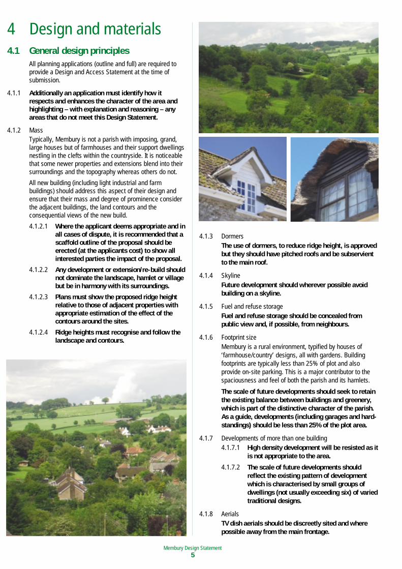
56 Membury Neighbourhood Plan 4.04 − March 2017Membury Design Statement5
4 Design and materials4.1 General design principles
All planning applications (outline and full) are required toprovide a Design and Access Statement at the time ofsubmission.
4.1.1 Additionally an application must identify how itrespects and enhances the character of the area andhighlighting – with explanation and reasoning – anyareas that do not meet this Design Statement.
4.1.2 MassTypically, Membury is not a parish with imposing, grand,large houses but of farmhouses and their support dwellingsnestling in the clefts within the countryside. It is noticeablethat some newer properties and extensions blend into theirsurroundings and the topography whereas others do not.
All new building (including light industrial and farmbuildings) should address this aspect of their design andensure that their mass and degree of prominence considerthe adjacent buildings, the land contours and theconsequential views of the new build.
4.1.2.1 Where the applicant deems appropriate and inall cases of dispute, it is recommended that ascaffold outline of the proposal should beerected (at the applicants cost) to show allinterested parties the impact of the proposal.
4.1.2.2 Any development or extension/re-build shouldnot dominate the landscape, hamlet or villagebut be in harmony with its surroundings.
4.1.2.3 Plans must show the proposed ridge heightrelative to those of adjacent properties withappropriate estimation of the effect of thecontours around the sites.
4.1.2.4 Ridge heights must recognise and follow thelandscape and contours.
4.1.3 DormersThe use of dormers, to reduce ridge height, is approvedbut they should have pitched roofs and be subservientto the main roof.
4.1.4 SkylineFuture development should wherever possible avoidbuilding on a skyline.
4.1.5 Fuel and refuse storageFuel and refuse storage should be concealed frompublic view and, if possible, from neighbours.
4.1.6 Footprint sizeMembury is a rural environment, typified by houses of‘farmhouse/country’ designs, all with gardens. Buildingfootprints are typically less than 25% of plot and alsoprovide on-site parking. This is a major contributor to thespaciousness and feel of both the parish and its hamlets.
The scale of future developments should seek to retainthe existing balance between buildings and greenery,which is part of the distinctive character of the parish.As a guide, developments (including garages and hard-standings) should be less than 25% of the plot area.
4.1.7 Developments of more than one building4.1.7.1 High density development will be resisted as it
is not appropriate to the area.
4.1.7.2 The scale of future developments shouldreflect the existing pattern of developmentwhich is characterised by small groups ofdwellings (not usually exceeding six) of variedtraditional designs.
4.1.8 AerialsTV dish aerials should be discreetly sited and wherepossible away from the main frontage.
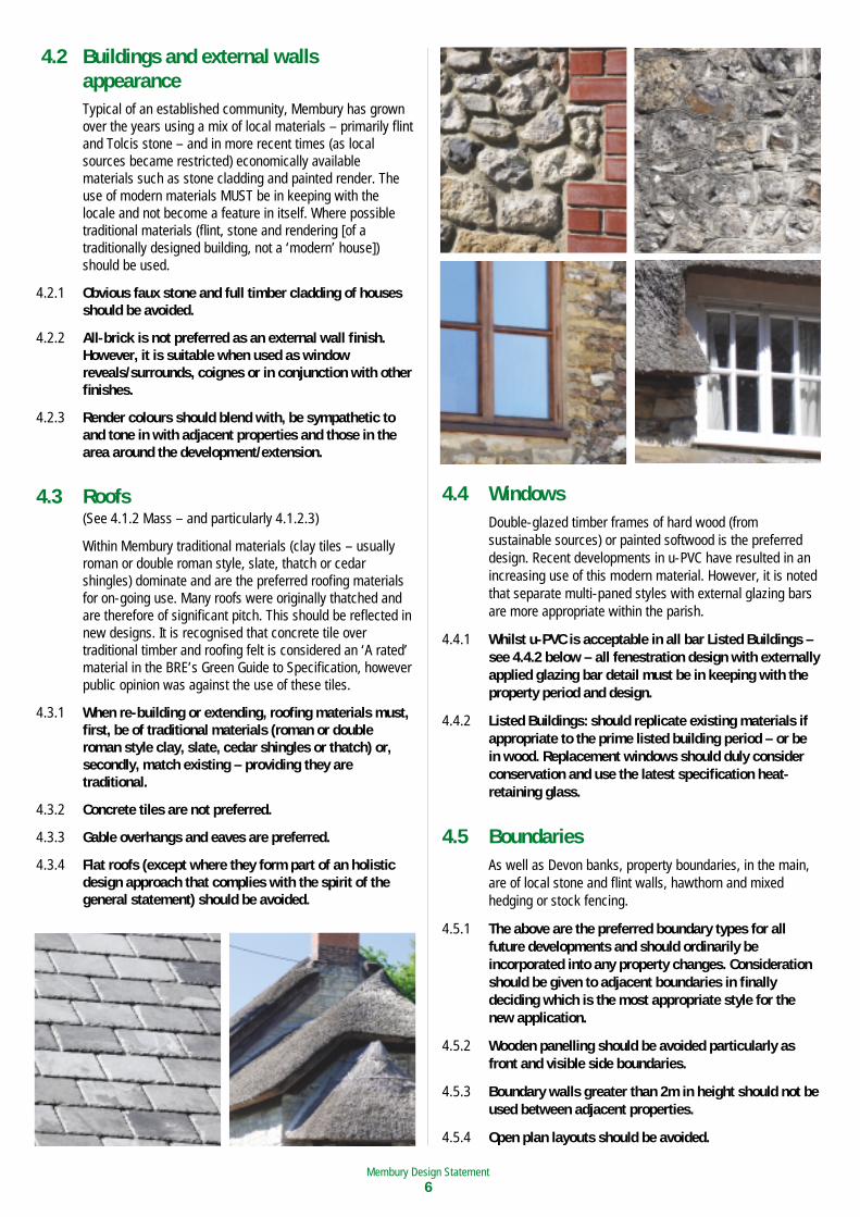
57Membury Neighbourhood Plan 4.04 − March 2017Membury Design Statement
6
4.2 Buildings and external wallsappearanceTypical of an established community, Membury has grownover the years using a mix of local materials – primarily flintand Tolcis stone – and in more recent times (as localsources became restricted) economically availablematerials such as stone cladding and painted render. Theuse of modern materials MUST be in keeping with thelocale and not become a feature in itself. Where possibletraditional materials (flint, stone and rendering [of atraditionally designed building, not a ‘modern’ house])should be used.
4.2.1 Obvious faux stone and full timber cladding of housesshould be avoided.
4.2.2 All-brick is not preferred as an external wall finish.However, it is suitable when used as windowreveals/surrounds, coignes or in conjunction with otherfinishes.
4.2.3 Render colours should blend with, be sympathetic toand tone in with adjacent properties and those in thearea around the development/extension.
4.3 Roofs(See 4.1.2 Mass – and particularly 4.1.2.3)
Within Membury traditional materials (clay tiles – usuallyroman or double roman style, slate, thatch or cedarshingles) dominate and are the preferred roofing materialsfor on-going use. Many roofs were originally thatched andare therefore of significant pitch. This should be reflected innew designs. It is recognised that concrete tile overtraditional timber and roofing felt is considered an ‘A rated’material in the BRE’s Green Guide to Specification, howeverpublic opinion was against the use of these tiles.
4.3.1 When re-building or extending, roofing materials must,first, be of traditional materials (roman or doubleroman style clay, slate, cedar shingles or thatch) or,secondly, match existing – providing they aretraditional.
4.3.2 Concrete tiles are not preferred.
4.3.3 Gable overhangs and eaves are preferred.
4.3.4 Flat roofs (except where they form part of an holisticdesign approach that complies with the spirit of thegeneral statement) should be avoided.
4.4 WindowsDouble-glazed timber frames of hard wood (fromsustainable sources) or painted softwood is the preferreddesign. Recent developments in u-PVC have resulted in anincreasing use of this modern material. However, it is notedthat separate multi-paned styles with external glazing barsare more appropriate within the parish.
4.4.1 Whilst u-PVC is acceptable in all bar Listed Buildings –see 4.4.2 below – all fenestration design with externallyapplied glazing bar detail must be in keeping with theproperty period and design.
4.4.2 Listed Buildings: should replicate existing materials ifappropriate to the prime listed building period – or bein wood. Replacement windows should duly considerconservation and use the latest specification heat-retaining glass.
4.5 BoundariesAs well as Devon banks, property boundaries, in the main,are of local stone and flint walls, hawthorn and mixedhedging or stock fencing.
4.5.1 The above are the preferred boundary types for allfuture developments and should ordinarily beincorporated into any property changes. Considerationshould be given to adjacent boundaries in finallydeciding which is the most appropriate style for thenew application.
4.5.2 Wooden panelling should be avoided particularly asfront and visible side boundaries.
4.5.3 Boundary walls greater than 2m in height should not beused between adjacent properties.
4.5.4 Open plan layouts should be avoided.
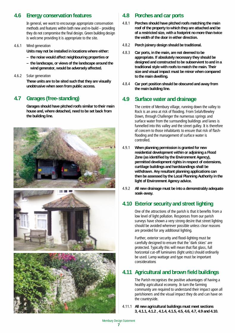
58 Membury Neighbourhood Plan 4.04 − March 2017Membury Design Statement7
4.6 Energy conservation featuresIn general, we want to encourage appropriate conservationmethods and features within both new and re-build – providingthey do not compromise the final design. Green building designis welcome providing it is appropriate to the site.
4.6.1 Wind generationUnits may not be installed in locations where either:
– the noise would affect neighbouring properties or
– the landscape, or views of the landscape around thewind generator, would be adversely affected.
4.6.2 Solar generationThese units are to be sited such that they are visuallyunobtrusive when seen from public access.
4.7 Garages (free-standing)Garages should have pitched roofs similar to their mainhouse and, where detached, need to be set back fromthe building line.
4.8 Porches and car ports4.8.1 Porches should have pitched roofs matching the main
roof of the property to which they are attached and beof a restricted size, with a footprint no more than twicethe width of the door in either direction.
4.8.2 Porch joinery design should be traditional.
4.8.3 Car ports, in the main, are not deemed to beappropriate. If absolutely necessary they should bedesigned and constructed to be subservient to and in atraditional style with roofs to match the main. Theirsize and visual impact must be minor when comparedto the main dwelling.
4.8.4 Car port position should be obscured and away fromthe main building line.
4.9 Surface water and drainageThe centre of Membury village, running down the valley toRock is an area at risk of flooding. From Selah/BewleyDown, through Challenger the numerous springs andsurface water from the surrounding buildings and lanes isfunnelled into this valley and the street gulley. It is thereforeof concern to those inhabitants to ensure that risk of flash-flooding and the management of surface water iscontrolled.
4.9.1 When planning permission is granted for newresidential development within or adjoining a FloodZone (as identified by the Environment Agency),permitted development rights in respect of extensions,curtilage buildings and hardstandings shall bewithdrawn. Any resultant planning applications canthen be assessed by the Local Planning Authority in thelight of Environment Agency advice.
4.9.2 All new drainage must be into a demonstrably adequatesoak-away.
4.10 Exterior security and street lightingOne of the attractions of the parish is that it benefits from alow level of light pollution. Responses from our parishsurveys have shown a very strong desire that street lightingshould be avoided wherever possible unless clear reasonsare provided for any additional lighting.
Further, exterior security and flood-lighting must becarefully designed to ensure that the ‘dark skies’ areprotected. Typically this will mean that flat glass, fullhorizontal cut-off luminaires (light units) should ordinarilybe used. Lamp wattage and type must be importantconsiderations
4.11 Agricultural and brown field buildingsThe Parish recognises the positive advantages of having ahealthy agricultural economy. In turn the farmingcommunity are required to understand their impact upon allparishioners and the visual impact they do and can have onthe countryside.
4.11.1 All new agricultural buildings must meet sections 3, 4.1.1, 4.1.2 , 4.1.4, 4.1.5, 4.5, 4.6, 4.7, 4.9 and 4.10.
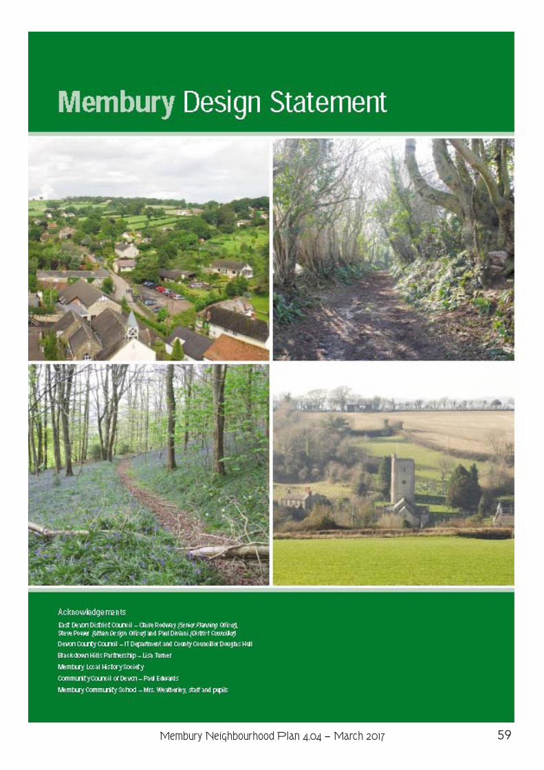
59Membury Neighbourhood Plan 4.04 − March 2017
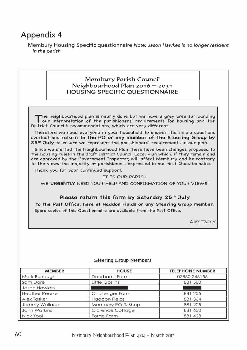
60 Membury Neighbourhood Plan 4.04 − March 2017
Appendix 4 Membury Housing Specific questionnaire Note: Jason Hawkes is no longer resident
in the parish
Membury Parish Council Neighbourhood Plan 2016 — 2031
HOUSING SPECIFIC QUESTIONNAIRE
The neighbourhood plan is nearly done but we have a grey area surrounding our interpretation of the parishioners’ requirements for housing and the
District Council’s recommendations, which are very different. Therefore we need everyone in your household to answer the simple questions
overleaf and return to the PO or any member of the Steering Group by 25th July to ensure we represent the parishioners’ requirements in our plan.Since we started the Neighbourhood Plan there have been changes proposed to
the housing rules in the draft District Council Local Plan which, if they remain and are approved by the Government Inspector, will affect Membury and be contrary to the views the majority of parishioners expressed in our first Questionnaire.Thank you for your continued support.
IT IS OUR PARISHWE URGENTLY NEED YOUR HELP AND CONFIRMATION OF YOUR VIEWS!
Please return this form by Saturday 25th July to the Post Office, here at Haddon Fields or any Steering Group member.Spare copies of this Questionnaire are available from the Post Office.
Alex Tasker
Steering Group Members
MEMBER HOUSE TELEPHONE NUMBERMark Burrough Deerhams Farm 07860 246156Sam Dare Little Goslins 881 580Jason Hawkes Red Lion House 881 243Heather Pearse Challenger Farm 881 255Alex Tasker Haddon Fields 881 364Jeremy Wallace Membury PO & Shop 881 225John Watkins Clarence Cottage 881 630Nick Yool Forge Farm 881 428
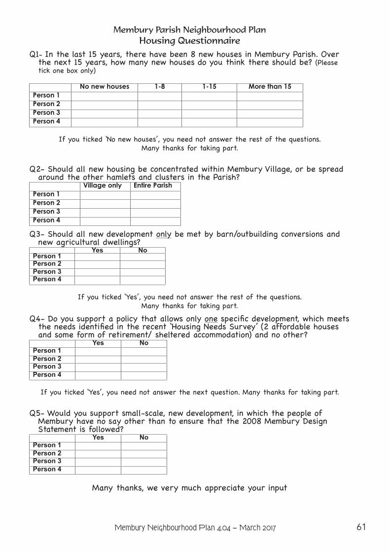
61Membury Neighbourhood Plan 4.04 − March 2017
Membury Parish Neighbourhood PlanHousing Questionnaire
Q1- In the last 15 years, there have been 8 new houses in Membury Parish. Over the next 15 years, how many new houses do you think there should be? (Please tick one box only)
No new houses 1-8 1-15 More than 15Person 1Person 2Person 3Person 4
If you ticked ‘No new houses’, you need not answer the rest of the questions. Many thanks for taking part.
Q2- Should all new housing be concentrated within Membury Village, or be spread around the other hamlets and clusters in the Parish?
Village only Entire ParishPerson 1Person 2Person 3Person 4
Q3- Should all new development only be met by barn/outbuilding conversions and new agricultural dwellings?
Yes NoPerson 1Person 2Person 3Person 4
If you ticked ‘Yes’, you need not answer the rest of the questions. Many thanks for taking part.
Q4- Do you support a policy that allows only one specific development, which meets the needs identified in the recent ‘Housing Needs Survey’ (2 affordable houses and some form of retirement/ sheltered accommodation) and no other?
Yes NoPerson 1Person 2Person 3Person 4
If you ticked ‘Yes’, you need not answer the next question. Many thanks for taking part.
Q5- Would you support small-scale, new development, in which the people of Membury have no say other than to ensure that the 2008 Membury Design Statement is followed?
Yes NoPerson 1Person 2Person 3Person 4
Many thanks, we very much appreciate your input
62 Membury Neighbourhood Plan 4.04 − March 2017
Appendix 5Refer to Meeting Community Housing needs, Policy HP3.1
Definition of ”Local Families” and ”Local Elderly”Over the past 50 years this parish, like many others, has seen small properties bought and
re-developed to make them more commercially attractive. Consequently the more affordable properties have been removed from the market/housing mix. It has become extremely difficult for young people to stay within the parish and own their own home.
The intention of this policy is for the parish to support a community house building project, possibly using a Community Land Trust [CLT] or some similar parish legal entity, primarily for the benefit of parishioners. This should provide low cost houses for younger families together with homes for elderly residents, for the latter probably on a commercial basis. The implementation of this policy will enable young people to remain in the parish by making available low cost homes. Additionally, they might provide employment in maintenance support (be it cleaning, laundering, gardening or decorating etc.) for the older residents. Thus, it is hoped, the mature can down-size yet stay within the community and their social sphere; free up their properties for up-scaling locals or new residents - thereby enabling housing market movement; the continued evolvement of the parish; promoting local employment for local people and keeping a wide age range demographic.
The Steering Group commissioned a Housing Needs Survey conducted by the Community Council of Devon[40] [see footnote 32, page 27] which indicated an on-going requirement of approximately 2 affordable houses and a much larger (20) interest in housing for the elderly. At the time of writing ”affordable” housing has developed its own connotation, therefore we have tended to use the apolitical term ”low cost housing”. All political parties are promoting their own ideas for providing affordable houses.
A CLT is a mechanism whereby the parish (through the Parish Council) can own in perpetuity the site thus taking out the land cost and any subsequent market inflation from the final property price - thus reducing the cost of the home. There are other mechanisms which attempt to achieve the same end and it is also possible to design and build a lower cost home. The current political trends suggest that other new government initiatives may emerge over coming years and should be considered.
Selection must be through a criteria based policy giving priority to parishioners. The criteria must recognise applicants’ length of time living in the parish and/or closeness of association with the parish through direct family plus their contribution within our community. It is not intended just to help reduce the area’s housing waiting list. Elderly would normally be regarded as over the age of 55.
There are potential sites which will meet all the requirements of this Plan.It will be the responsibility of the parish council through their CLT management committee
to define their selection criteria but it should be a priority-based selection which reflects the connection to the parish both in terms of length of residency and/or closeness to family members currently living in the parish plus any contribution that the applicants have made to the parish.
These prioritised criteria should apply whether selecting suitable local families or local elderly.
40 The Community Council of Devon is now known as Devon Communities Together
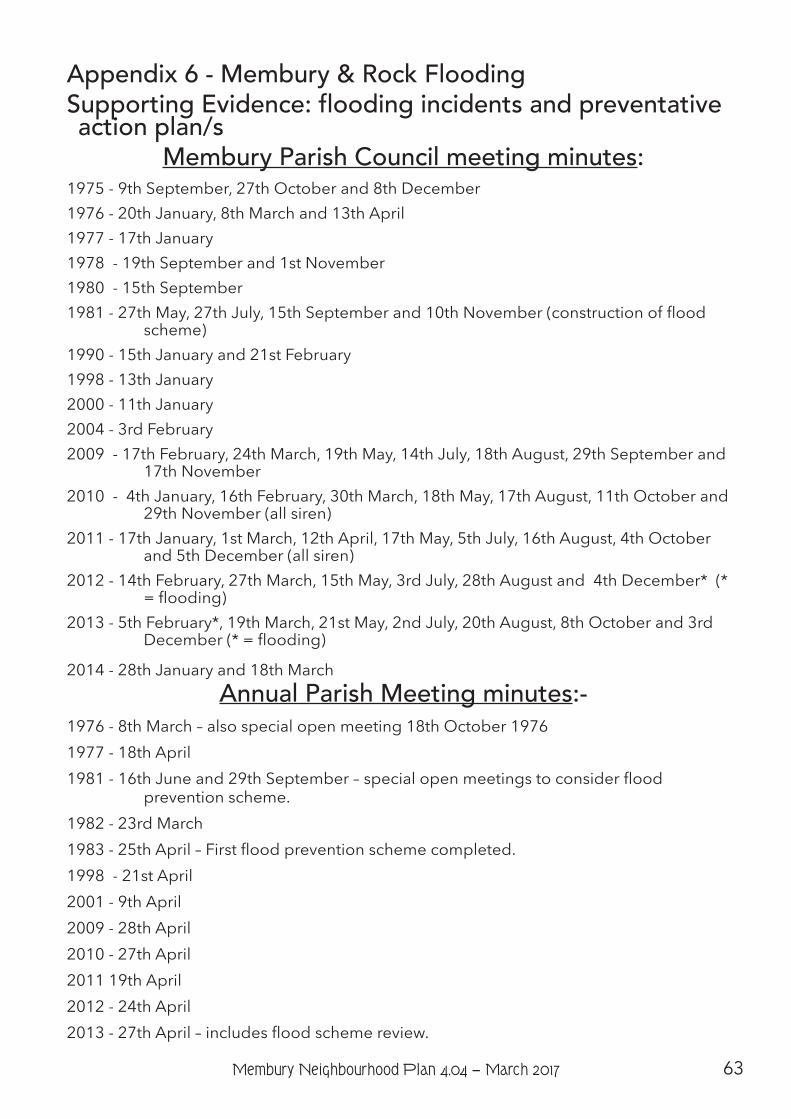
63Membury Neighbourhood Plan 4.04 − March 2017
Appendix 6 - Membury & Rock FloodingSupporting Evidence: flooding incidents and preventative action plan/s
Membury Parish Council meeting minutes:1975 - 9th September, 27th October and 8th December1976 - 20th January, 8th March and 13th April1977 - 17th January1978 - 19th September and 1st November1980 - 15th September1981 - 27th May, 27th July, 15th September and 10th November (construction of flood
scheme)1990 - 15th January and 21st February1998 - 13th January2000 - 11th January2004 - 3rd February2009 - 17th February, 24th March, 19th May, 14th July, 18th August, 29th September and
17th November2010 - 4th January, 16th February, 30th March, 18th May, 17th August, 11th October and
29th November (all siren)2011 - 17th January, 1st March, 12th April, 17th May, 5th July, 16th August, 4th October
and 5th December (all siren)2012 - 14th February, 27th March, 15th May, 3rd July, 28th August and 4th December* (*
= flooding)2013 - 5th February*, 19th March, 21st May, 2nd July, 20th August, 8th October and 3rd
December (* = flooding)
2014 - 28th January and 18th MarchAnnual Parish Meeting minutes:-
1976 - 8th March – also special open meeting 18th October 19761977 - 18th April1981 - 16th June and 29th September – special open meetings to consider flood
prevention scheme.1982 - 23rd March1983 - 25th April – First flood prevention scheme completed.1998 - 21st April2001 - 9th April2009 - 28th April2010 - 27th April2011 19th April2012 - 24th April2013 - 27th April – includes flood scheme review.
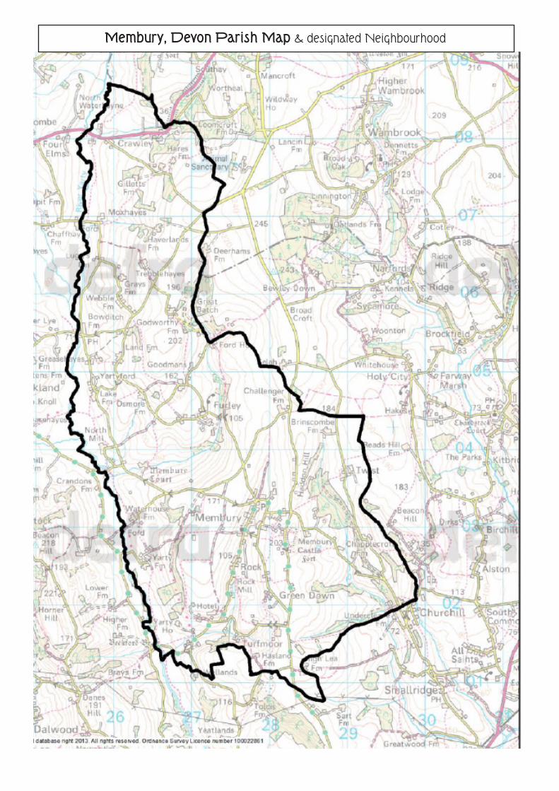
Membury, Devon Parish Map & designated Neighbourhood