nz transport agency christchurch southern motorway...
TRANSCRIPT
Christchurch Southern Motorway Stage 2
Project benefitsCSM2 will be able to carry more than double the traffic volumes of the current route with improved access to Christchurch and Selwyn districts. It will bring significant economic benefits for Canterbury and the wider South Island. The project is expected to: • halve travel times between
Rolleston and Christchurch CBD at peak times from around 30 minutes to about 15 minutes (based on 2041 traffic figures)
• reduce congestion and crashes on the surrounding road network
• support continuing growth across the wider Selwyn District
• reduce traffic volumes on State Highway 1 (Main South Road) through Templeton, including over 2000 fewer trucks per day
• reduce traffic volumes on many local roads making them safer for pedestrians, cyclists and public transport.
Without the new motorway, traffic volumes on Main South Road would be expected to double in the next 15 years making access to and crossing Main South Road difficult and less safe.
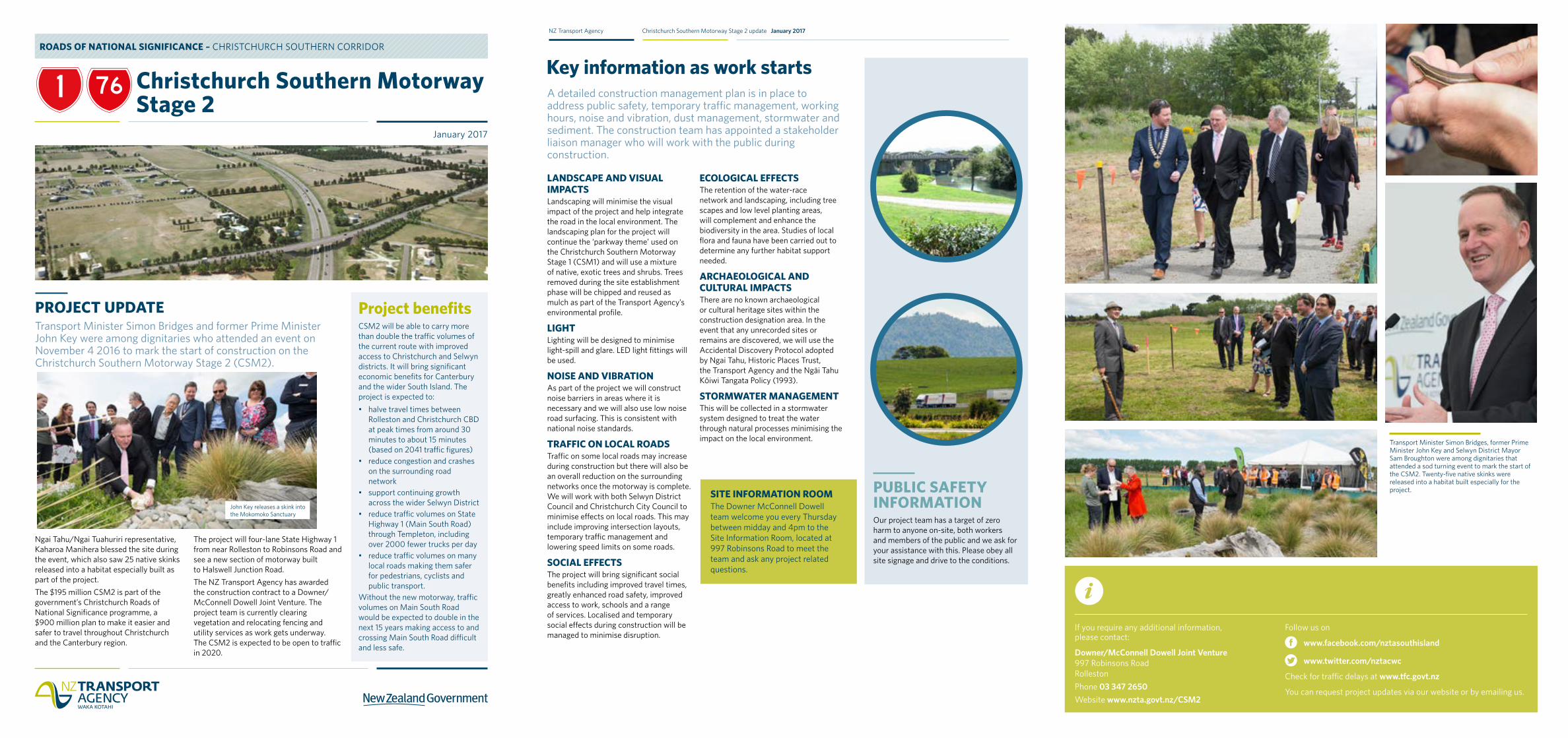
Transport Minister Simon Bridges and former Prime Minister John Key were among dignitaries who attended an event on November 4 2016 to mark the start of construction on the Christchurch Southern Motorway Stage 2 (CSM2).
Ngai Tahu/Ngai Tuahuriri representative, Kaharoa Manihera blessed the site during the event, which also saw 25 native skinks released into a habitat especially built as part of the project. The $195 million CSM2 is part of the government’s Christchurch Roads of National Significance programme, a $900 million plan to make it easier and safer to travel throughout Christchurch and the Canterbury region.
The project will four-lane State Highway 1 from near Rolleston to Robinsons Road and see a new section of motorway built to Halswell Junction Road. The NZ Transport Agency has awarded the construction contract to a Downer/McConnell Dowell Joint Venture. The project team is currently clearing vegetation and relocating fencing and utility services as work gets underway. The CSM2 is expected to be open to traffic in 2020.
PROJECT UPDATE
ROADS OF NATIONAL SIGNIFICANCE – CHRISTCHURCH SOUTHERN CORRIDOR
January 2017
John Key releases a skink into the Mokomoko Sanctuary
PUBLIC SAFETY INFORMATIONOur project team has a target of zero harm to anyone on-site, both workers and members of the public and we ask for your assistance with this. Please obey all site signage and drive to the conditions.
LANDSCAPE AND VISUAL IMPACTSLandscaping will minimise the visual impact of the project and help integrate the road in the local environment. The landscaping plan for the project will continue the ‘parkway theme’ used on the Christchurch Southern Motorway Stage 1 (CSM1) and will use a mixture of native, exotic trees and shrubs. Trees removed during the site establishment phase will be chipped and reused as mulch as part of the Transport Agency’s environmental profile.
LIGHTLighting will be designed to minimise light-spill and glare. LED light fittings will be used.
NOISE AND VIBRATIONAs part of the project we will construct noise barriers in areas where it is necessary and we will also use low noise road surfacing. This is consistent with national noise standards.
TRAFFIC ON LOCAL ROADSTraffic on some local roads may increase during construction but there will also be an overall reduction on the surrounding networks once the motorway is complete. We will work with both Selwyn District Council and Christchurch City Council to minimise effects on local roads. This may include improving intersection layouts, temporary traffic management and lowering speed limits on some roads.
SOCIAL EFFECTSThe project will bring significant social benefits including improved travel times, greatly enhanced road safety, improved access to work, schools and a range of services. Localised and temporary social effects during construction will be managed to minimise disruption.
ECOLOGICAL EFFECTSThe retention of the water-race network and landscaping, including tree scapes and low level planting areas, will complement and enhance the biodiversity in the area. Studies of local flora and fauna have been carried out to determine any further habitat support needed.
ARCHAEOLOGICAL AND CULTURAL IMPACTSThere are no known archaeological or cultural heritage sites within the construction designation area. In the event that any unrecorded sites or remains are discovered, we will use the Accidental Discovery Protocol adopted by Ngai Tahu, Historic Places Trust, the Transport Agency and the Ngāi Tahu KŌiwi Tangata Policy (1993).
STORMWATER MANAGEMENTThis will be collected in a stormwater system designed to treat the water through natural processes minimising the impact on the local environment.
A detailed construction management plan is in place to address public safety, temporary traffic management, working hours, noise and vibration, dust management, stormwater and sediment. The construction team has appointed a stakeholder liaison manager who will work with the public during construction.
Key information as work starts
NZ Transport Agency Christchurch Southern Motorway Stage 2 update January 2017
SITE INFORMATION ROOM The Downer McConnell Dowell team welcome you every Thursday between midday and 4pm to the Site Information Room, located at 997 Robinsons Road to meet the team and ask any project related questions.
If you require any additional information, please contact:
Downer/McConnell Dowell Joint Venture 997 Robinsons Road Rolleston Phone 03 347 2650 Website www.nzta.govt.nz/CSM2
Follow us on
www.facebook.com/nztasouthisland
www.twitter.com/nztacwc
Check for traffic delays at www.tfc.govt.nz
You can request project updates via our website or by emailing us.
Transport Minister Simon Bridges, former Prime Minister John Key and Selwyn District Mayor Sam Broughton were among dignitaries that attended a sod turning event to mark the start of the CSM2. Twenty-five native skinks were released into a habitat built especially for the project.
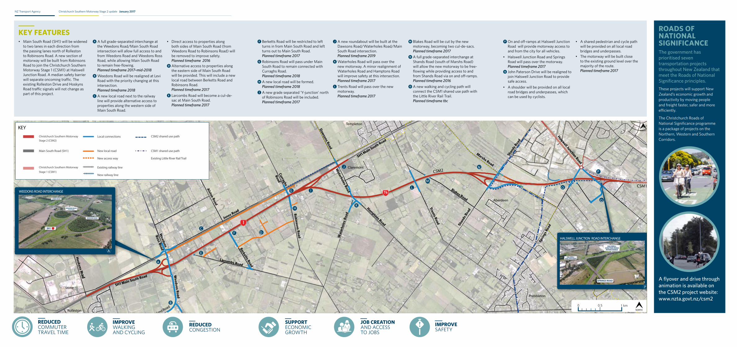
• Main South Road (SH1) will be widened to two lanes in each direction from the passing lanes north of Rolleston to Robinsons Road. A new section of motorway will be built from Robinsons Road to join the Christchurch Southern Motorway Stage 1 (CSM1) at Halswell Junction Road. A median safety barrier will separate oncoming traffic. The existing Rolleston Drive and Hoskyns Road traffic signals will not change as part of this project.
A A full grade-separated interchange at the Weedons Road/Main South Road intersection will allow full access to and from Weedons Road and Weedons Ross Road, while allowing Main South Road to remain free-flowing. Planned timeframe 2017–mid-2018
B Weedons Road will be realigned at Levi Road with the priority changing at this intersection. Planned timeframe 2018
C A new local road next to the railway line will provide alternative access to properties along the western side of Main South Road.
• Direct access to properties along both sides of Main South Road (from Weedons Road to Robinsons Road) will be removed to improve safety. Planned timeframe 2016
D Alternative access to properties along the eastern side of Main South Road will be provided. This will include a new local road between Berketts Road and Robinsons Road. Planned timeframe 2017
E Larcombs Road will become a cul-de-sac at Main South Road. Planned timeframe 2017
KEY FEATURES ROADS OF NATIONAL SIGNIFICANCEThe government has prioritised seven transportation projects throughout New Zealand that meet the Roads of National Significance principles. These projects will support New Zealand’s economic growth and productivity by moving people and freight faster, safer and more efficiently.
The Christchurch Roads of National Significance programme is a package of projects on the Northern, Western and Southern Corridors.
A flyover and drive through animation is available on the CSM2 project website: www.nzta.govt.nz/csm2
Blakes Road
Trents Road
Wat
erho
les R
oad
Shan
ds R
oad
Shand
s Roa
d
Curraghs
Road
Alston Road
Dawsons Road
Waterholes Road
Berketts Road
Weedons Road
Weedons
Ross Road
Larcombs Road
Jones Road
SH1 Main South Road
SH1 Main South Road
Hamptons Road
Marshs Road
Halswell Junction Road
Hoskyns Road
Robinsons Road
Templeton
Claremont
Rolleston
Izone
Aberdeen
Hornby
Prebbleton
CSM1
CSM2
Sprin
gs R
oad
ycnegA tropsnarT ZNCSM2 Project Update April 2014Christchurch Southern Motorway Stage 2
Blakes Road
Trents Road
Wat
erho
les R
oad
Shan
ds R
oad
Shand
s Roa
d
Curraghs
Road
Alston Road
Dawsons Road
Waterholes Road
Berketts Road
Weedons Road
Weedons
Ross Road
Larcombs Road
Jones Road
SH1 Main South Road
SH1 Main South Road
Hamptons Road
Marshs Road
Halswell Junction Road
Hoskyns Road
Robinsons Road
Templeton
Claremont
Rolleston
Izone
Aberdeen
Hornby
Prebbleton
CSM1
CSM2
Sprin
gs R
oad
NORTH
NORTH
KEY
Christchurch Southern Motorway Stage 2 (CSM2)
Local connections CSM2 shared use path
Main South Road (SH1) New local road
New access way
CSM1 shared use path
Existing Little River Rail Trail
Christchurch Southern Motorway
Stage 1 (CSM1)Existing railway line
New railway line
L
I
J
K
P
Q
O
N
M
LWEEDONS ROAD INTERCHANGE
WEEDONS RD
MAIN SOUTH RD (SH1)
JONES RD
A
HALSWELL JUNCTION ROAD INTERCHANGE
SPRINGS RD
CSM2
HALSWELL JUNCTION RD
P
KEY FEATURES
The government has prioritised seven transportation projects throughout New Zealand that meet the Roads of
principles. These projects will support New Zealand’s economic growth and productivity by moving people and
The Christchurch RoNS project is a package of works on the Northern, Western and Southern Corridors. The Christchurch Southern Motorway Stage 2 completes the Southern Corridor.
ROADS OF NATIONAL SIGNIFICANCE RoNS)
animation is available on the project website www.nzta.govt.nz/csm2
B
E
CF D
H
G
A
• Main South Road (SH1) will be widened to two lanes in each direction from the passing lanes north of Rolleston to Robinsons Road. A new section of motorway will be built from Robinsons Road to join the Christchurch Southern Motorway Stage 1 (CSM1) at Halswell Junction Road. A median safety barrier will separate
Rolleston Drive and Hoskyns Rnot change as part of this project.
• A full grade-separated interchange at the Weedons Road/Main South Road intersection will allow full access to and from Weedons Road and Weedons Ross Road, while allowing Main South Road to
• Weedons Road will be realigned at Levi Road, with the priority changing at this intersection.
• A new local road next to the railway line will provide alternative access to properties along the western side of Main South Road.
• Direct access to properties along both sides of Main South Road (from Weedons Road to Robinsons Road will be removed to improve safety).
• Alternative access to properties along the eastern side of Main South Road will be provided. This will include a new local road between Berketts Road and Robinsons Road.
• Larcombs Road will be closed at Main South Road.
• Berketts Road will be restricted to left turns in from Main South Road and left turns out to Main South Road.
• Robinsons Road will pass under Main South Road to remain connected with Curraghs Road.
• provided between Curraghs Road and Dawsons Road.
• A new grade separated ‘Y-junction’ north of Robinsons Road will be included.
• A new roundabout will be built at the Dawsons Road/Waterholes Road/Main South Road intersection.
• Waterholes Road will pass over the new motorway. A minor realignment of Waterholes Road and Hamptons Road will improve safety at this intersection.
• Trents Road will pass over the new motorway.
• Blakes Road will be cut by the new motorway, becoming two cul-de-sacs.
• A full grade-separated ‘diamond’ interchange at Shands Road (south of Marshs Road) will allow the new motorway
and from Shands R
• A new walking and cycling path will connect the CSM1 shared use path with the Little River Rail Trail.
• O Halswell Junction Road will provide motorway access to and from the city for all vehicles.
• Halswell Junction Road and Springs Road will pass over the motorway.
• John Paterson Drive will be realigned to join Halswell Junction Road to provide safe access.
• A 1.5m wide shoulder will be provided on all local road bridges and underpasses, which can be used by cyclists.
• A shared pedestrian and cycle path will be provided on the Trents Road and Marshs Road bridges, with pedestrian footpaths included on all the other local road bridges and underpasses.
• The motorway will be built close to the existing ground level.
A
B
C I
J
K
P
Q
O
N
M
LE
F
DH
G
IMPROVE WALKING AND CYCLING
REDUCED COMMUTER TRAVEL TIME
SUPPORT ECONOMIC GROWTH
JOB CREATION AND ACCESS TO JOBS
REDUCED CONGESTION
IMPROVE SAFETY
Levi Road
IMPROVE WALKING AND CYCLING
REDUCED COMMUTER TRAVEL TIME
SUPPORT ECONOMIC GROWTH
REDUCED CONGESTION
JOB CREATION AND ACCESS TO JOBS
IMPROVE SAFETY
NZ Transport Agency Christchurch Southern Motorway Stage 2 update January 2017
F Berketts Road will be restricted to left turns in from Main South Road and left turns out to Main South Road. Planned timeframe 2017
G Robinsons Road will pass under Main South Road to remain connected with Curraghs Road. Planned timeframe 2018
H A new local road will be formed. Planned timeframe 2018
I A new grade separated ‘Y-junction’ north of Robinsons Road will be included. Planned timeframe 2017
J A new roundabout will be built at the Dawsons Road/Waterholes Road/Main South Road intersection. Planned timeframe 2019
K Waterholes Road will pass over the new motorway. A minor realignment of Waterholes Road and Hamptons Road will improve safety at this intersection. Planned timeframe 2017
L Trents Road will pass over the new motorway. Planned timeframe 2017
M Blakes Road will be cut by the new motorway, becoming two cul-de-sacs. Planned timeframe 2017
N A full grade-separated interchange at Shands Road (south of Marshs Road) will allow the new motorway to be free-flowing while providing access to and from Shands Road via on and off-ramps. Planned timeframe 2016
O A new walking and cycling path will connect the CSM1 shared use path with the Little River Rail Trail. Planned timeframe tbc
P On and off-ramps at Halswell Junction Road will provide motorway access to and from the city for all vehicles.
• Halswell Junction Road and Springs Road will pass over the motorway. Planned timeframe 2017
Q John Paterson Drive will be realigned to join Halswell Junction Road to provide safe access.
• A shoulder will be provided on all local road bridges and underpasses, which can be used by cyclists.
• A shared pedestrian and cycle path will be provided on all local road bridges and underpasses.
• The motorway will be built close to the existing ground level over the majority of the route. Planned timeframe 2017