national spatial data infrastructure (nsdi) work … spatial data infrastructure (nsdi) work session...
TRANSCRIPT
National Spatial Data Infrastructure (NSDI) Work Session
National Geospatial Preparedness Summit
John Mahoney
Federal Geographic Data Committee
September 14, 2016
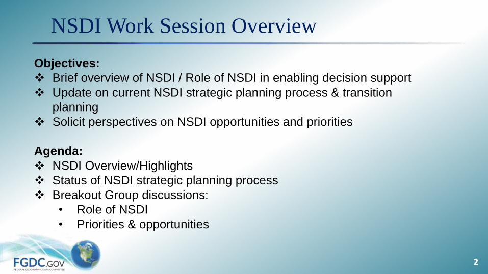
NSDI Work Session Overview
2
Objectives:
Brief overview of NSDI / Role of NSDI in enabling decision support
Update on current NSDI strategic planning process & transition
planning
Solicit perspectives on NSDI opportunities and priorities
Agenda:
NSDI Overview/Highlights
Status of NSDI strategic planning process
Breakout Group discussions:
• Role of NSDI
• Priorities & opportunities
3
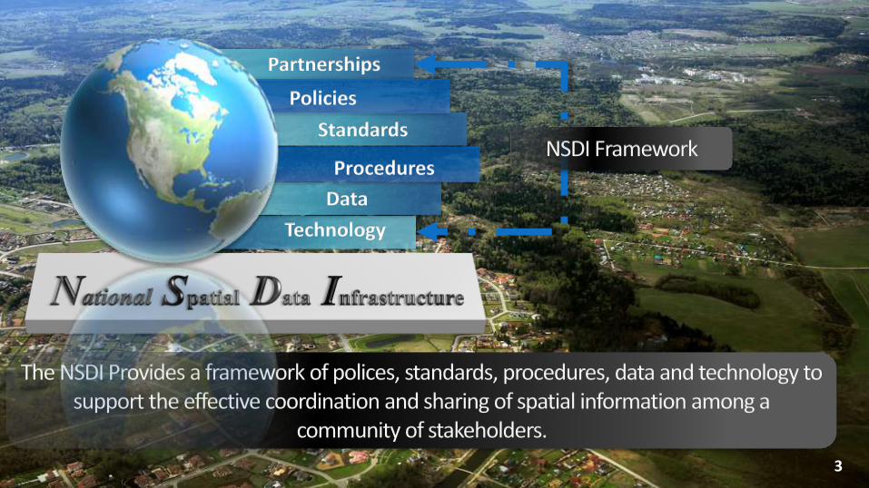
The NSDI Provides a framework of polices, standards, procedures, data and technology to support the effective coordination and sharing of spatial information among a
community of stakeholders.
Standards
Policies
Data
Procedures
Technology
Partnerships
NSDI Framework

4
Federal
State & Local
Tribal
NSDI Partnerships & Collaboration
Academia
Private & Professional
International
5
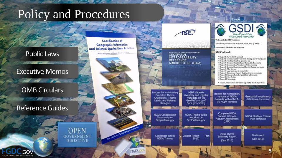
Policy and Procedures
Public Laws
Executive Memos
OMB Circulars
Reference Guides

Final
Approve
Standard for
Endorsement
FGDC Steering Committee
DraftProjectProposal
Develop Proposal
Standards Working Group
ReviewProposal Setup Project
Produce Working
Draft
Standards Development Group
Review Working
Draft
Review
Review &
Evaluate
Committee Draft
Approve
Standard for
Public Review
Coordinate
Public ReviewRespond to
Public Review
Evaluate
Responsiveness
to Public
Comments
Approve
Standard for
Endorsement
Coordination GroupStandards Working Group
Standards Development Group
Standards Working Group
1 2 3
6
4 5
7 8 91
0
FGDC SecretariatCoordination Group
Subcommittee/Working Group
Subcommittee/Working Group
Standards facilitate development, sharing, and use of geospatial data and services
6
Standards & Interoperability
1
1
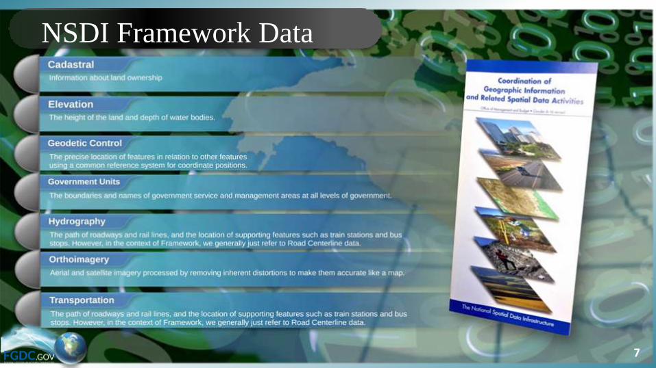
NSDI Framework Data
7
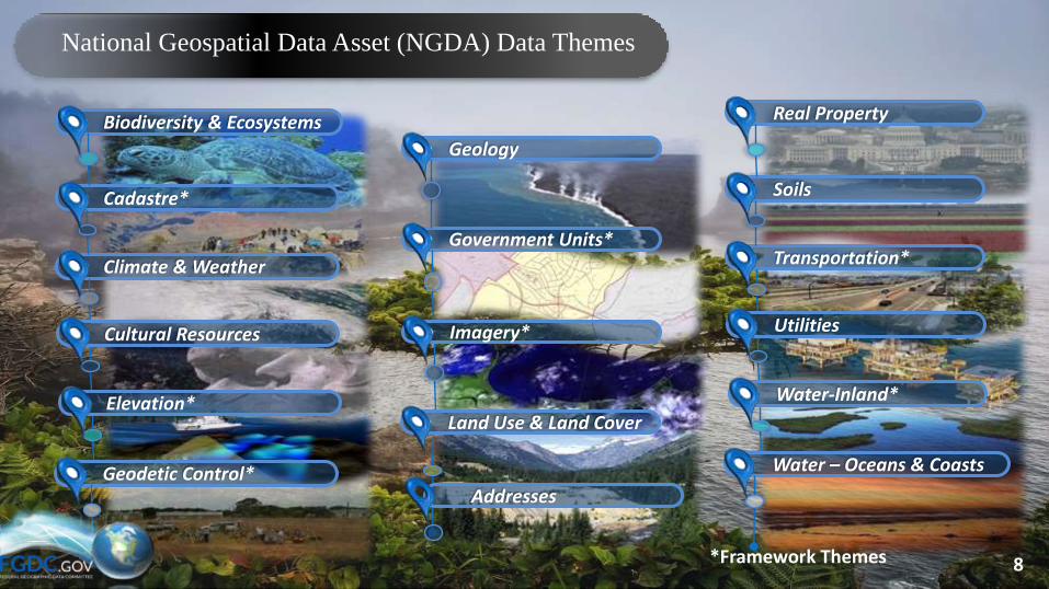
Geology
Government Units*
Imagery*
Land Use & Land Cover
Biodiversity & Ecosystems
Cadastre*
Climate & Weather
Cultural Resources
Elevation*
Geodetic Control*
Real Property
Soils
Transportation*
Utilities
Water-Inland*
Water – Oceans & Coasts
National Geospatial Data Asset (NGDA) Data Themes
8
Addresses
*Framework Themes
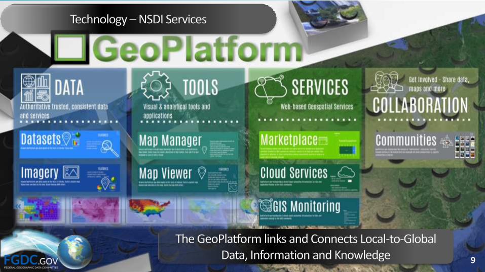
Technology –NSDI Services
The GeoPlatform links and Connects Local-to-Global Data, Information and Knowledge 9

Where We’ve Been – 2014-2016 NSDI Strategic Plan
Current Strategic Plan includes:
• Shared National Vision
• Strategic Goals, Objectives, and Actions
• Roles & Responsibilities
• Guiding Principles
• Implementation Approach
11

Implementation Highlights
12
Geospatial Interoperable Reference Architecture (GIRA)• Governance framework & technical architecture guidance
GeoPlatform.gov• Enhanced communities, Wiki for data standards collaboration,
updated Marketplace function, GeoCloud deployment of key public-facing geospatial Web services
NGDA Portfolio Management• Registration of NGDA Datasets in catalog, completion of the
baseline NGDA Dataset Lifecycle Maturity Assessments Standards
• FGDC endorsement of five additional standards, implementation of ISO metadata standards
International Activities• FGDC Global Geospatial Information Management (GGIM)
Working Group
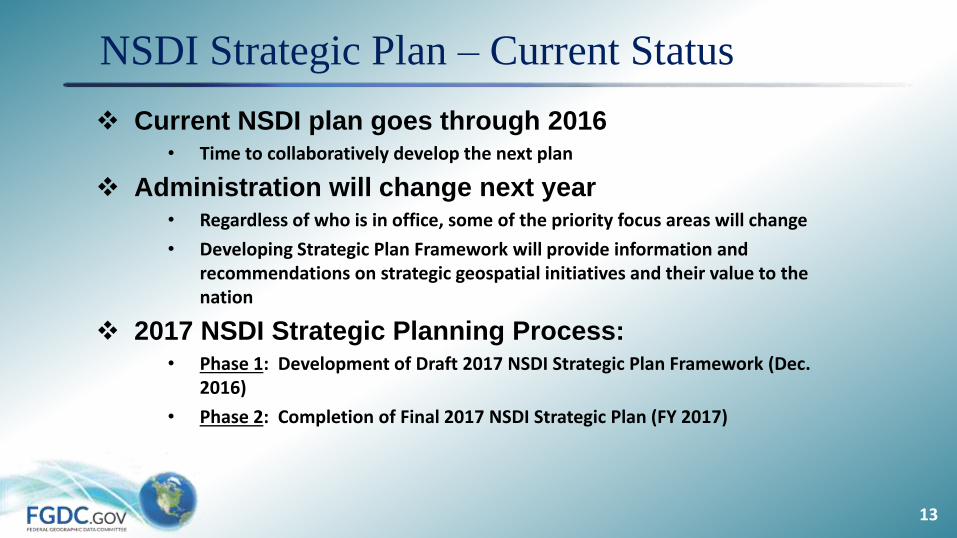
NSDI Strategic Plan – Current Status
13
Current NSDI plan goes through 2016• Time to collaboratively develop the next plan
Administration will change next year • Regardless of who is in office, some of the priority focus areas will change
• Developing Strategic Plan Framework will provide information and recommendations on strategic geospatial initiatives and their value to the nation
2017 NSDI Strategic Planning Process:• Phase 1: Development of Draft 2017 NSDI Strategic Plan Framework (Dec.
2016)
• Phase 2: Completion of Final 2017 NSDI Strategic Plan (FY 2017)
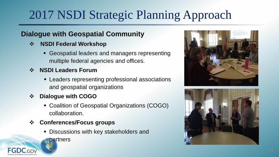
2017 NSDI Strategic Planning Approach
14
Dialogue with Geospatial Community
NSDI Federal Workshop
Geospatial leaders and managers representing
multiple federal agencies and offices.
NSDI Leaders Forum
Leaders representing professional associations
and geospatial organizations
Dialogue with COGO
Coalition of Geospatial Organizations (COGO)
collaboration.
Conferences/Focus groups
Discussions with key stakeholders and
partners

2017 NSDI Strategic Planning Approach
15
National Geospatial Advisory Committee Inputs
NSDI Strategic Plan
Feedback on the current NSDI strategic plan &
National Geospatial Data Asset portfolio
management process.
Emerging Technologies
Advice & recommendations on how new
technologies will impact the geospatial community
Policy Framework
Advice on how FGDC policy framework might be
updated to reflect changes in technology,
organizational capabilities, and the evolution of the
geospatial community

NSDI Strategic Planning Feedback Sources
16
Feedback Source Date
COGO Report Card and FGDC Briefing to COGO 2/6/2015; 6/28/2016
Theme Lead Discussion Forum (Esri FedGIS) 2/25/2016
NSDI Strategic Plan – Federal Workshop 3/22/2016
NGAC Meeting – NSDI Strategic Framework 4/6-7/2016
NGAC NSDI Working Group 5/13/2016
NGAC Meeting – NSDI Strategic Plan WG Report 6/14-15/2016
NGAC NGDA MP Working Group Report June 2016
NSDI Leaders Forum 7/26/2016
NGAC Meeting – NSDI Strategic Framework 6/15/2016
Tribal Focus Group 8/18/2016
NGDA Evaluation Report (Draft) In progress
NGAC Emerging Technologies Subcommittee In progress
NGAC Policy Framework Subcommittee In progress
Other Focus Groups In progress

NSDI Strategic Plan Feedback Summary
Current NSDI Strategic Plan• Includes a national vision but currently has a federal focus
• Promoted key initiatives, including:
• Geospatial Platform
• Geospatial Interoperability Reference Model (GIRA)
• National Geospatial Data Asset (NGDA) portfolio management
• Opened internal agency communications, helped to identify a
community of practitioners, and raised level of
visibility/awareness of significant datasets
• Did not include communication plan/tools (e.g., social media) and
outreach roadmap
17

NSDI Strategic Plan Feedback Summary
Scope of Plan• Expand on the “national” element of the plan to be more inclusive of non-
federal partners and stakeholders
• Incorporate goals for emerging domains such as cyber infrastructure
protection and geospatial privacy
• Increase communication and outreach, including new branding and
messaging, to better engage partners
Value and Benefits• Recognize NSDI and NGDAs as critical digital infrastructure for the
nation.
• Raise level of visibility/awareness of significant datasets (e.g., framework
data) and consider a “tiered” approach
• Emphasize use cases to demonstrate utility of NSDI for decision support.
18

NSDI Strategic Plan Feedback Summary
Roles and Responsibilities• Focus greater emphasis on the role of the private sector & non-Federal
partners in the NSDI, and build and sustain public/private partnerships
Policy and Governance• OMB Circular A-16, last updated in 2002, does not adequately address
the current geospatial landscape and should be revised and modernized.
• The new Administration should consider working with Congress to enact
legislation codifying the requirements of Circular A-16 and providing
statutory authority for the development and maintenance of the NSDI and
the supporting activities of the FGDC.
19
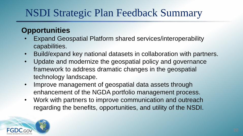
NSDI Strategic Plan Feedback Summary
Opportunities• Expand Geospatial Platform shared services/interoperability
capabilities.
• Build/expand key national datasets in collaboration with partners.
• Update and modernize the geospatial policy and governance
framework to address dramatic changes in the geospatial
technology landscape.
• Improve management of geospatial data assets through
enhancement of the NGDA portfolio management process.
• Work with partners to improve communication and outreach
regarding the benefits, opportunities, and utility of the NSDI.
20

Breakout #1
Small Group Discussion 1 (15 min)
• What is the value of the national spatial data infrastructure (NSDI) to your community? What does it help you do? What might it help you do better?
Task:
• 15 minute group discussions
• Identify 3 key points
• Each group reports results
21
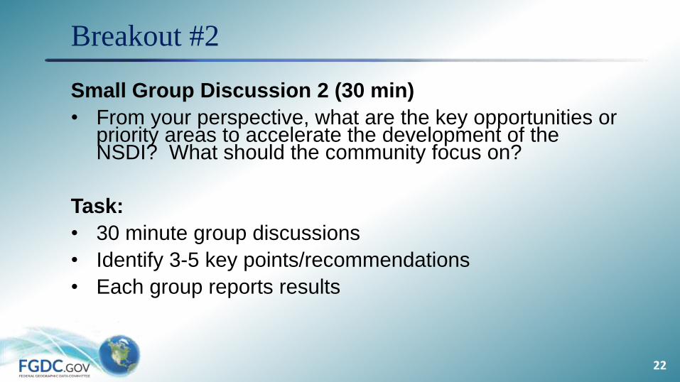
Breakout #2
Small Group Discussion 2 (30 min)
• From your perspective, what are the key opportunities or priority areas to accelerate the development of the NSDI? What should the community focus on?
Task:
• 30 minute group discussions
• Identify 3-5 key points/recommendations
• Each group reports results
22