spatial data infrastructure department of space · vinay k dadhwal associate director national...
TRANSCRIPT

Vinay K DadhwalAssociate Director
National Remote Sensing Centre (ISRO)
NSDI 10; December 23-24, 2010, New Delhi
Spatial Data Infrastructure
Department of Space
NNRMS Framework Status & Future

National Natural Resources Management
System (NNRMS) : ISRO / DOSRS ApplicationsRS Applications
• Agriculture & Soils
• Environment & Forest
• Natural Resources
(Land & Ocean)
• Disaster Management
• Weather & Climate Studies
• Large Scale Mapping
EO infrastructureEO infrastructure
Ground Segment
DIP, GIS, GPS, Photogrammetry, DSS, etc
Space Segment
Enabling Techniques
….. NNRMS integrates the data obtained through Remote Sensing into the existing System with appropriate Technical, Managerial and Organisational linkages
– NNRMS Mandate 1985

NRSC Satellite Data ArchivesNRSC Satellite Data Archives

INTERNET
NR Services
User client
NNRMS PortalNNRMS Portal
NRC
(1:250K / 50K;
7-8 Layers;
Every 5 years)
Other Projects
(All Scale;
when available;
User defined)
Cadastral LIS
(1:4,000+;
Referenced;
“Spot” Database)
LSM
(1:10,000;
New Basemap)
NRR Information generation
Create and maintain a systematic archive of all the digital spatial
data of thematic and base maps generated using remotely sensed
data
Other NNRMS Projects
NNRMS: NR Repository – Major elements
Regional servers
NR Data Base
SPACENET
Master Server
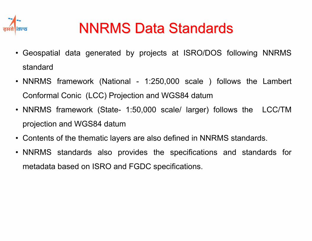
NNRMS Data StandardsNNRMS Data Standards
• Geospatial data generated by projects at ISRO/DOS following NNRMS
standard
• NNRMS framework (National - 1:250,000 scale ) follows the Lambert
Conformal Conic (LCC) Projection and WGS84 datum
• NNRMS framework (State- 1:50,000 scale/ larger) follows the LCC/TM
projection and WGS84 datum
• Contents of the thematic layers are also defined in NNRMS standards.
• NNRMS standards also provides the specifications and standards for
metadata based on ISRO and FGDC specifications.

AIRPORT- Point
BLOCK- Point
CANALS
COMPOSITE LAND DEV.
PLAN
DESERTIFICATION STATUS
MAPPING
DISTRICT
DISTRICT HEADQUATERS
DISTRICT ROADS
DRAINAGE
EROSION
FOREST MANAGEMENT
GEOMORPHOLOGY
GOLDEN QUDRATERAL
GROUND WATER
PROSPECTS
HIERARCHICAL REGION
HYDROLOGICAL SOIL
GROUP
INDIA BOUNDARY
LAND CAPABILITY
LAND IRRIGABILITY
LAND RESOURCES DEV.
PLAN
LANDUSE/LANDCOVER
LITHOLOGY
NATIONAL HIGHWAY
PROTECTED FOREST
AND RF
RAIL
RAILWAY STATIONS
RESERVED AND
PROTECTED FOREST
RESERVOIRS
RIVERS
ROADS
RURAL ROADS
SETTLEMENTS
SLOPE
SOIL IRRIGABILITY
SOIL PRODUCTIVITY
STATE
STRUCTURE
SURFACE WATER
TALUK
VILLAGE BOUNDARIES
WASTELAND MAPPING
WATER QUALITY FOR
DRINKING
WATER QUALITY FOR IRRIGATION
WATER RES.DEV. PLAN - AREA
WATER RES.DEV. PLAN - LOCATION
WATERSHED
WATERSHED PRIORITISATION
WELLS
WETLAND BOUNDARIES 1994
WETLAND BOUNDARIES 2005
WETLAND POSTMONSOON 1994
WETLAND POSTMONSOON 2005
WETLAND PREMONSOON 1994
WETLAND
Spatial Data Layers under NRDB- Major
More than 1200 layers

Data & Information Service Sharing Policy
• OGC compliant WMS for all the geo-spatial data
is freely available (Visualization & query)
• Metadata in public domain (NNRMS/NRDB);
• Digital classified data sharing as per Map Policy
of Government of India;
• Digital classified data (up to 1:50,000 scale) is
freely shared with Indian Government
organizations
• Remote sensing image data sharing as per
RSDP
• RSDP 2010 is in approval stage
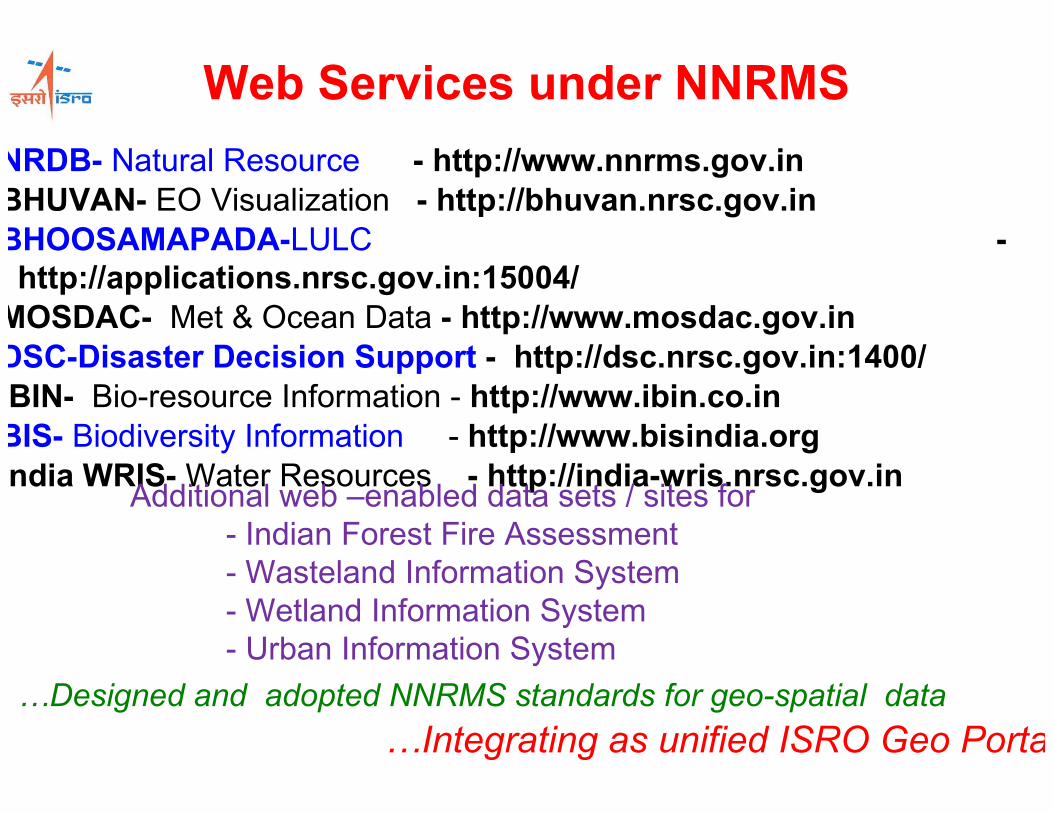
Web Services under NNRMS
NRDB- Natural Resource - http://www.nnrms.gov.in
BHUVAN- EO Visualization - http://bhuvan.nrsc.gov.in
BHOOSAMAPADA-LULC -
http://applications.nrsc.gov.in:15004/
MOSDAC- Met & Ocean Data - http://www.mosdac.gov.in
DSC-Disaster Decision Support - http://dsc.nrsc.gov.in:1400/
IBIN- Bio-resource Information - http://www.ibin.co.in
BIS- Biodiversity Information - http://www.bisindia.org
India WRIS-Water Resources - http://india-wris.nrsc.gov.in
…Integrating as unified ISRO Geo Portal
…Designed and adopted NNRMS standards for geo-spatial data
Additional web –enabled data sets / sites for
- Indian Forest Fire Assessment
- Wasteland Information System
- Wetland Information System
- Urban Information System
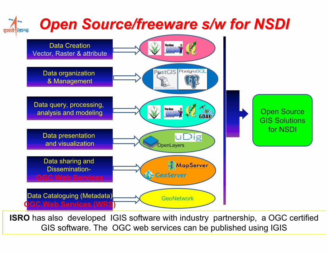
Open Source/freeware s/w for NSDIOpen Source/freeware s/w for NSDI
Data Creation
Vector, Raster & attribute
Data organization
& Management
Data query, processing,
analysis and modeling
Data presentation
and visualization
Data sharing and
Dissemination-
OGC Web Services
OpenLayers
Open Source
GIS Solutions
for NSDI
Data Cataloguing (Metadata)
OGC Web Services (WRS)GeoNetwork
ISRO has also developed IGIS software with industry partnership, a OGC certified
GIS software. The OGC web services can be published using IGIS

BhuvanBhuvan-- ISRO EO VisualizationISRO EO Visualization•A Geoportal of ISRO showcasing Indian EO
Capabilities in Multi-sensor, Multi-platform
and Multi-temporal domain.
•It is a gateway to explore and discover
virtual earth in 3D space with specific
emphasis on Indian region.
http://bhuvan.nrsc.gov.inRelease 1.0 - 12th Aug’2009
Release 2.0 - 22nd Sep’2010

Bhuvan : Data & Services
• Services
– Land, Weather, Ocean &
Disaster
Sl.
NO
Theme Scale Current-ness Remarks Size
1 Oceansat-1 OCM
Oceansat-2 OCM
360 m
360 m
1999,2004,2006
2009
India(100%)
India(100%)
9GB
2 IRS P6 – Resourcesat1 -
AWiFS
56 m 2006
2008
2008(3 Season)
2008-09
India(100%)
5 Deg Visibility
India (100%)
Global(80%)
20GB
80GB
70GB
1TB
3 IRS P6 – Resourcesat1 – LISS
III
23.5 m 2008 India(100%) 80GB
4 IRS P6 – Resourcesat1 – LISS
IV MX
5.8 m 2006-09 India(80%) 800GB
5 IRS P4 – LISS III + PAN
Merged
5.8 m 2005-06 India(100%) 800GB
6 SRTM 90m 2007 Global(100%) 200GB
7 Cartosat-2 0.8m 2007 26 Cities 8 GB

BhuvanBhuvan-- Contents & ServicesContents & Services
Raster Data
•Oceansat-2 (OCM)- 27-28 Sept. 2009 (Indian Region)
•Oceansat-1 (OCM)- 1999, 2000 and 2006 (Indian Region);
•Advaced Wide Field Sensor (AWiFS)- 2008, 2006 (Indian Region);
•Linear Imaging Self Scanning Sensor (LISS-III)- 2008 (Indian Region)
•Linear Imaging Self Scanning Sensor (LISS-IV)- 2008 (80% of India)
Information Layers
•Drought (NDVI)- 2009, 2008 and 2002;
•Flood Layers (Selected);
•Automatic Weather Stations- Point Locations;
•Watershed Layers;
•Ground Water Prospects-
•Wasteland National Wasteland(Scale 1:50000) District Statistics ;
•State wasteland(Scale 1:50000) Andhra Pradesh and Karnataka ;
•Soil (Scale 1:50000) District wise Soil Texture info.;
•Soil(Scale 1:250000) Erosion , Texture , Productivity and Slope ;
•State Soil Texture(1:50000) Karnaatka and Mizoram .
•Administrative Layers );
•Transportations:

•BHOOSAMPADA : interactive GIS environment in
internet domain for LULC data visualization, querying and
analysis.
•Temporal data on LULC-250K, Water bodies and Snow
cover available with dynamic linkage of socioeconomic
data.
•BHOOSAMPADA is developed using open source and
COTS GIS solutions.
http://applications.nrsc.gov.in:15001/
BHOOSAMPADABHOOSAMPADA-- LULC Information LULC Information
Portal Portal
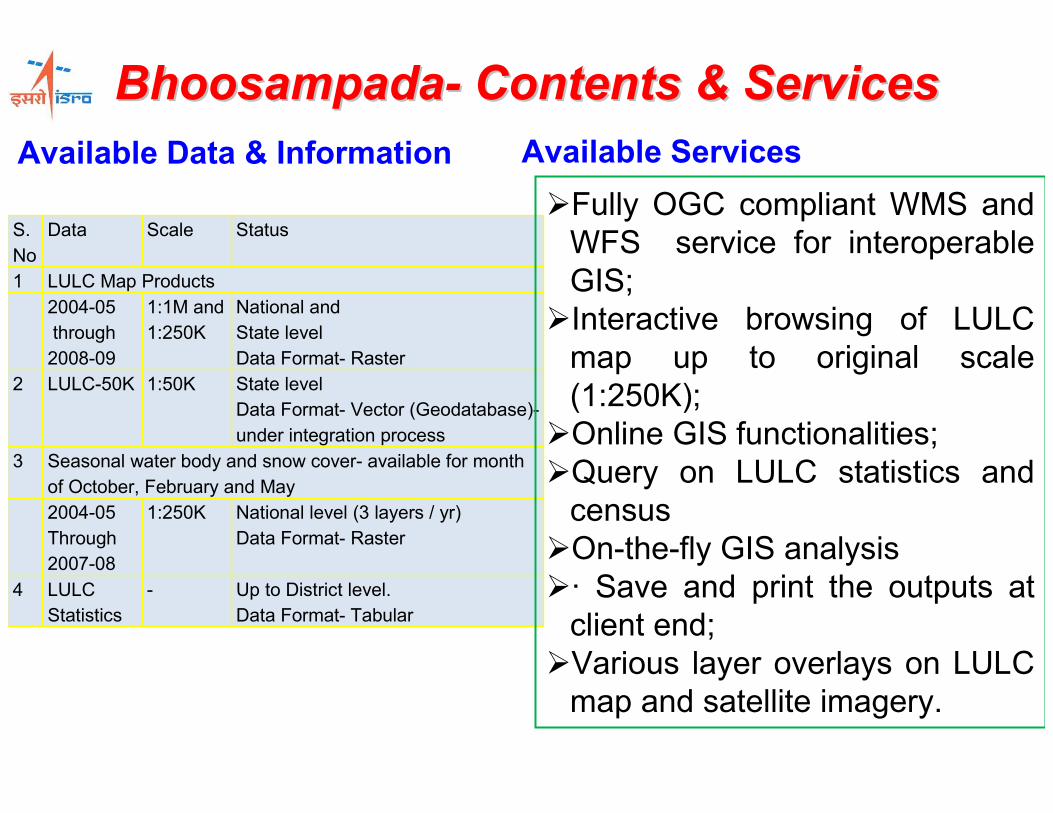
BhoosampadaBhoosampada-- Contents & ServicesContents & Services
S.
No
Data Scale Status
1 LULC Map Products
2004-05
through
2008-09
1:1M and
1:250K
National and
State level
Data Format- Raster
2 LULC-50K 1:50K State level
Data Format- Vector (Geodatabase)-
under integration process
3 Seasonal water body and snow cover- available for month
of October, February and May
2004-05
Through
2007-08
1:250K National level (3 layers / yr)
Data Format- Raster
4 LULC
Statistics
- Up to District level.
Data Format- Tabular
Available Data & Information
�Fully OGC compliant WMS and
WFS service for interoperable
GIS;
�Interactive browsing of LULC
map up to original scale
(1:250K);
�Online GIS functionalities;
�Query on LULC statistics and
census
�On-the-fly GIS analysis
�· Save and print the outputs at
client end;
�Various layer overlays on LULC
map and satellite imagery.
Available Services

MOSDACMOSDAC-- Meteorological and Oceanographic Meteorological and Oceanographic Satellite Data Archival Centre Satellite Data Archival Centre
� MOSDAC archives all Met. & Ocean Satellite data for Indian region,
analyzed fields from model and station data
� The data distribution is through prior registration of users
� The data is available through MOSDAC Portal
� The data is also supplied through media on demand
� Anonymous user can only browse the available data
� MOSDAC SERVICES
oWeather Forecast
oCyclone Tracking
oCloud Movement
o…..


MOSDAC – Data Diversity & Volume
• Derived Products
– 12 Sources : 300 MB/ day
– MODIS, AQUA, SSMI, AVHRR, ERBE, NECP,
ECMWRF, …
• Archived Satellite Analysed Fields
– 9 Sources : 230 GB/ year
– NECP, SSMI, AMSU, TMI, ScARAB, …
• Current Archive exceeds : 960 GB
• Active Live Raw Data : IMD & DOS Satellite
Archives

Capacity Building
• Indian Institute of Remote Sensing (estd. 1966)
– Mtech (2001), MSc (2001), PG-Diploma (1966)
• NRSC, Hyderabad
– 12 Week Course
• Indian Institute of Space Technology
– Btech to PhD (all space technology)
• User training, awareness, project specific
500 + per Year
• Satellite (EDUSAT) based : 60 Univ / 2000 /yr

Thank YouThank You
VK Dadhwal
Associate Director
NRSC / ISRO
Hyderabad, INDIA
http://www.nrsc.gov.in